Part 2 — CHAPTER I. (continued 2)
Reading edition
They are also considered by Zurla.[455] The first general account of them was given by Humboldt in the Examen Critique,[456] and to what he did little if anything has since been added. D’Avezac[457] treated the subject, giving a brief sketch of the islands known to the Arab geographers,—a curious matter which deserves more attention.
Still more recently Paul Gaffarel has treated the matter briefly, but carefully.[458] A study of old maps by H. Wuttke, in the Jahresbericht des Vereins für Erdkunde zu Dresden,[459] gives considerable attention to the islands; and Theobald Fischer, in his commentary on the collection of maps reproduced by Ongania, has briefly touched on the subject,[460] as has Cornelio Desimoni in various papers in the Atti della Società Ligure di Storia patria, xiv., and other years, in the Atti dell’ Acad. dei Nuova Lincei, in the Gionale ligustico, etc. R. H. Major’s Henry the Navigator should also be consulted.[461]
Strictly speaking, the term mythical islands ought to include, if not Frisland and Drogeo, at least the land of Bus, the island of Bimini with its fountain of life, an echo of one of the oldest of folk-tales, the island of Saxenburg, and the other non-existent islands, shoals, and rocks, with which the imagination of sailors and cartographers have connected the Atlantic even into the present century. In fact, the name is by common consent restricted to certain islands which occur constantly on old charts: the Island of St. Brandan, Antillia or Isle of the Seven Cities, Satanaxio, Danmar, Brazil, Mayda, and Isla Verte. It is interesting to note that the Arab geographers had their fabulous islands, too, though so little is known of them that it is at present impossible to say what relation they bear to those mentioned. They say that Ptolemy assigned 25,000 islands to the Atlantic, but they name and describe seventeen only, among which we may mention the Eternal Islands (Canaries? Azores?),[462] El-Ghanam (Madeira?), Island of the Two Sorcerers (Lancerote?), etc.[463]
There has been some difference of opinion as to which of the Atlantic islands answer to the ancient conception of the Fortunate Islands. It is probable that the idea is at the bottom of several of these, but it may be doubted whether the island of St. Brandan is not entirely due to the christianizing of this ancient fable.
We proceed now to examine the accounts of some of these islands.
St. Brandan.—St. Brandan, or Brendan, who died May 16, 577, was Abbot of Cluainfert, in Ireland, according to the legend, where he was visited by a friend, Barontus, who told him that far in the ocean lay an island which was the land promised to the saints. St. Brandan set sail for this island in company with 75 monks, and spent seven years upon the ocean, in two voyages (according to the Irish text in the MS. book of Lismore, which is probably the most archaic form of the legend), discovering this island and many others equally marvellous, including one which turned out to be the back of a huge fish, upon which they celebrated Easter. This story cannot be traced beyond the eleventh century, its oldest form being a Latin prose version in a MS. of that century. It is known also in French, English, and German translations, both prose and verse, and was evidently a great favorite in the Middle Ages. Intimately connected with the St. Brandan legend is that of St. Malo, or Maclovius, Bishop of Aleth, in Armorica, a disciple of St. Brandan, who accompanied his superior, and whose eulogists, jealous of the fame of the Irish saint, provided for the younger a voyage on his own account, with marvels transcending those found by Brandan. His church-day is November 17th. The story of St. Brandan is given by Humboldt and D’Avezac,[464] and by Gaffarel.[465] Further accounts will be found in the Acta Sanctorum of the Bollandists,[466] and in the introductions and notes to the numerous editions of the voyages, among which reference only need be made to the original Latin edited by M. Jubinal,[467] and to the English version edited by Thomas Wright for the Percy Society.[468] A Latin text of the fourteenth century is now to be found in the Acta Sanctorum Hiberniae ex codice Salmanticensi nunc premium integre edita opera C. de Smedt et J. de Backer (Edinb. etc., 1888), 4to, pp. 111-154. As is well known, Philoponus gives an account of the voyages of St. Brandan with a curious map, in which he places the island N. W. of Spain and N. E. of the Canaries, or Insulae Fortunatae.[469] The island of St. Brandan was at first apparently imagined in the north, but it afterward took a more southerly location. Honoré d’Autun identifies it with a certain island called Perdita, once discovered and then lost in the Atlantic; we have here, perhaps, some reminiscence of the name “Aprositos,” which Ptolemy bestows on one of the Fortunatae Insulae.[470] In some of the earlier maps there is an inlet on the west coast of Ireland called Lacus Fortunatus, which is packed with islands which are called Insulae Fortunatae or Beatae, and sometimes given as 300 or 368 in number.[471] But the Pizigani map of 1367 puts the Isole dicte Fortunate S. Brandany in the place of Madeira; and Behaim’s globe, in 1492, sets it down in the latitude of Cape de Verde,—a legend against it assigning the discovery to St. Brandan in 565.
It is this island which was long supposed to be seen as a mountainous land southeast of the Canaries. After the discovery of the Azores expeditions were fitted out to search for it, and were continued until 1721, which are described by Viera, and have been since retold by all writers on the subject.[472] The island was again reported as seen in 1759.
Antillia, or Isle of Seven Cities.—The largest of these islands, the one most persistent in its form and location, is Antillia, which is depicted as a large rectangular island, extending from north to south, lying in the mid-Atlantic about lat. 35° N. This island first appears on the map of 1424, preserved at Weimar, and is found on the principal maps of the rest of the century, notably in the Bianco of 1436.[473] On some maps of the sixteenth and seventeenth centuries appears a smaller island under the name of Sette Citade, or Sete Ciudades, which is properly another name for Antillia, as Toscanelli says in his famous letter, wherein he recommended Antillia as likely to be useful as a way-station on the India voyage. We owe to Behaim the preservation on his globe of 1492 of the legend of this island. It was discovered and settled, according to him, by refugees from Spain in 714, after the defeat of King Roderick by the Moors. The settlers were accompanied by an archbishop and six bishops, each of whom built him a town. There is a story that the island was rediscovered by a Portuguese sailor in 1447.[474]
In apparent connection with Antillia are the smaller islands Danmar or Tanmar, Reillo or Royllo, and Satanaxio. The latter alone is of special interest. Formaleoni found near Antillia, on the map of Bianco of 1436, an island with a name which he read as “Y.d laman Satanaxio,”—a name which much perplexed him, until he found, in an old Italian romance, a legend that in a certain part of India a great hand arose every day from the sea and carried off the inhabitants into the ocean. Adapting this tale to the west, he translated the name “Island of the hand of Satan,”[475] in which interpretation Humboldt acquiesced. D’Avezac, however, was inclined to think that there were two islands, one called Delamar, a name which elsewhere appears as Danmar or Tanmar, and Satanaxio, or, as it appears on a map by Beccario at Parma, Satanagio,[476] and suggests that the word is a corrupt form for S. Atanaxio or S. Atanagio, i. e. St. Athanasius, with which Gaffarel is inclined to agree.[477]
Formaleoni saw in Antillia a foreknowledge of the Antilles, and Hassel believed that North and South America were respectively represented by Satanaxio and Antillia, with a strait between, just as the American continent was indeed represented after the discovery. It is certainly curious that Beccario designates the group of Antillia, Satanagio, and Danmar, as Isle de novo reperte, the name afterwards applied to the discoveries of Columbus; but it is not now believed that the fifteenth-century islands were aught but geographical fancies. To transfer their names to the real discoveries was of course easy and natural.[478]
Brazil.—Among the islands which prefigured the Azores on fourteenth-century maps appears I. de Brazi on the Medicean portulano of 1351, and it is apparently Terceira or San Miguel.[479] On the Pizigani map of 1367 appear three islands with this name, Insula de Bracir or Bracie, two not far from the Azores, and one off the south or southeast end of Ireland. On the Catalan map of 1375 is an Insula de Brazil in the southern part of the so-called Azores group, and an Insula de Brazil (?) applied to a group of small islands enclosed in a heavy black ring west of Ireland. The same reduplication occurs in the Solerio of 1385, in a map of 1426 preserved at Regensburg, in Bianco’s map of 1436, and in that of 1448: here de Braxil is the easternmost of the Azores group (i. e. y de Colombi, de Zorzi, etc.), while the large round island—more like a large ink-blot than anything else—west of Ireland is y de Brazil d. binar.[480] In a map in St. Mark’s Library, Venice, dated about 1450, Brazil appears in four places. Fra Mauro puts it west of Ireland,[481] and it so appears in Ptolemy of 1519, and Ramusio in 1556; but Mercator and Ortelius inscribe it northwest of the Azores.
Humboldt has shown[482] that brazil-wood, being imported into Europe from the East Indies long before the discovery of America, gave its name to the country in the west where it was found in abundance, and he infers that the designation of the Atlantic island was derived from the same source. The duplication of the name, however, seems to point to a confusion of different traditions, and in the Brazil off Ireland we doubtless have an attempt to establish the mythical island of Hy Brazil, or O’Brasile, which plays a part as a vanishing island in Irish legends, although it cannot be traced to its origin. In the epic literature of Ireland relating to events of the sixth and subsequent centuries, and which was probably written down in the twelfth, there are various stories of ocean voyages, some involuntary, some voluntary, and several, like the voyage of the sons of Ua Corra about 540, of St. Brandan about 560, and of Mailduin in the eighth century, taking place in the Atlantic, and resulting in the discovery of numerous fabulous islands.[483] The name of Brazil does not appear in these early records, but it seems to belong to the same class of legends.[484] It is first mentioned, as far as I know, by William Betoner, called William of Worcester, who calls the island Brasyle and Brasylle, and says that July 15, 1480, his brother-in-law, John Jay, began a voyage from Bristol in search of the island, returning Sept. 18 without having found it.[485] This evidently belongs to the series of voyages made by Bristol men in search of this island, which is mentioned by Pedro d’Ayala, the Spanish ambassador to England, in his famous letter of July 25, 1498, where he says that such voyages in search of Brazylle and the seven cities had been made for seven years past, “according to the fancies of the Genoese,” meaning Sebastian Cabot.[486]
It would seem that the search for Brazil was of older date than Cabot’s arrival. He probably gave an additional impetus to the custom, adding to the stories of the fairy isles the legends of the Sette Citade or Antillia. Hardiman,[487] quoting from a MS. history of Ireland, in the library of the Royal Irish Academy, written about 1636, mentions an “iland, which lyeth far att sea, on the west of Connaught, and some times is perceived by the inhabitants of the Oules and Iris ... and from Saint Helen Head. Like wise several seamen have discovered it, ... one of whom, named Captain Rich, who lives about Dublin, of late years had a view of the land, and was so neere that he discovered a harbour ... but could never make to land” because of “a mist which fell upon him.... Allsoe in many old mappes ... you still find it by the name of O’Brasile under the longitude of 03°, 00´, and the latitude of 50° 20´.”[488] In 1675 a pretended account of a visit to this island was published in London, which is reprinted by Hardiman.[489]
An account of the island as seen from Arran given in O’Flaherty’s Sketch of the Island of Arran,[490] is quoted by H. Halliday Sterling, Irish Minstrelsy, p. 307 (London, 1887). Mr. Marshall, in a note in Notes and Queries, Sept. 22, 1883 (6th s., viii. 224), quotes Guest, Origines Celticae (London, 1883), i. 126, and R. O’Flaherty, Ogygia, sive rerum Hibernicarum chronologiae (London, 1685; also in English translation, Dublin, 1793), as speaking of O’Brazile. The latter work I have not seen. Mr. Marshall also quotes a familiar allusion to it by Jeremy Taylor (Dissuasive from Popery, 1667). This note was replied to in the same periodical, Dec. 15, 1883, by Mr. Kerslake, “N.” and W. Fraser. Fraser’s interest had been attracted by the entry of the island—much smaller than usual—on a map of the French Geographer Royal, Le Sieur Tassin, 1634-1652, and he read a paper before the Geological Society of Ireland, Jan. 20, 1870, suggesting that Brazil might be the present Porcupine Bank, once above water. On the same map Rockall is laid down as two islands, where but a solitary rock is now known.[491] Brasil appears on the maps of the last two centuries, with Mayda and Isle Verte, and even on the great Atlas by Jefferys, 1776, is inserted, although called “imaginary island of O’Brasil.” It grows constantly smaller, but within the second half of this century has appeared on the royal Admiralty charts as Brazil Rock.[492]
It would be too tedious to enumerate the numerous other imaginary islands of the Atlantic to which clouds, fogs, and white caps have from time to time given rise. They are marked on all charts of the last century in profusion; mention, however, may be made of the “land of Bus” or Busse, which Frobisher’s expedition coasted along in 1576, and which has been hunted for with the lead even as late as 1821, though in vain.
When Humboldt wrote the Examen Critique, Toscanelli’s letter to Columbus, of unknown date,[493] enclosing a copy of the one he sent to Martinez in 1474, was known only in the Italian form in Ulloa’s translation of the Historie del S. D. Fernando Colombo (Venice, 1571), and in the Spanish translation of Ulloa’s version by Barcia in the Historiades primitivos de las Indias occidentales (Madrid, 1749), i. 5 bis, which was reprinted by Navarrete, Coleccion de los viages y descubrimientos, etc., ii. p. 1. In the letter to Martinez, in this form, it is said that there are in the map which accompanied it twenty-six spaces between Lisbon and Quisai, each space containing 250 miles according to the Ulloa version, but according to the re-translation of Barcia 150 miles. This, with several other changes made by Barcia, were followed by Navarrete and accepted as correct by Humboldt, who severely censures Ximenes for adopting the Italian rendering in his Gnomone fiorent. But the Latin copy of the letter in Columbus’s handwriting, discovered by Harrisse and made public (with fac-simile) in his D. Fernando Colon (Seville, 1871),[494] sustained the correctness of Ulloa’s version, giving 250 miliaria to the space. This authoritative rendering also showed that while the translator had in general followed the text, he had twice inserted a translation of miles into degrees, and once certainly, incorrectly, making in one place 100 miles = 35 leagues, and in another, 2,500 miles = 225 leagues. Probably this discrepancy led to the omissions made by Barcia; he was wrong, however, in changing the number 250, supposing the 150 not to be a typographical error, and in omitting the phrase, “which space (from Lisbon to Quinsai) is about the third part of the sphere.” The Latin text showed, too, that this whole passage about distances was not in the Martinez letter at all, but formed the end of the letter to Columbus, since in the Latin it follows the date of the Martinez letter, into which it has been interpolated by a later hand. Finally the publication of Las Casas’s Historia de las Indias (Madrid, 1875) gave us another Spanish version, which differs from Barcia’s in closely agreeing with the Ulloa version, and which gives the length of a space at 250 miles.
There were then 26 × 250 = 6500 miles between Lisbon and Quinsai, and this was about one third of the circumference of the earth in this latitude, but it is not clear whether Roman or Italian miles were meant.
If the MS. in the Biblioteca Nazionale at Florence [Cod. Magliabechiano Classe xi. num. 121], described by G. Uzielli in the Bollettino della Società Geografica Italiana, x. 1 (1873), 13-28 (“Ricerche intorno a Paolo dal Pozzo Toscanelli, ii. Della grandezza della terra secondo Paolo Toscanelli”), actually represents the work of Toscanelli, it is of great value in settling this point. The MS. is inscribed “Discorso di Mo Paolo Puteo Toscanelli sopra la cometa del 1456.” In it were found two papers: 1. A plain projection in rectangular form apparently for use in sketching a map. It is divided into spaces, each subdivided into five degrees, and numbers 36 spaces in length. It is believed by Sig. Uzielli that this is the form used in the map sent to Martinez. If this be so, the 26 spaces between Lisbon and Quinsai = 130°. 2. A list of the latitude and longitude of various localities, at the end of which is inscribed this table:
Gradus continet .68 miliaria minus 3ª unius. Miliarum tria millia bracchia. Bracchium duos palmas. Palmus. 12. uncias. 7. filos.
The Florentine mile of 3,000 braccia da terra contains, according to Sig. Uzielli, 1653.6m. (as against 1481m. to the Roman mile). Hence Toscanelli estimated a degree of the meridian at 111,927m, or only 552m. more than the mean adopted by Bessel and Bayer. Since, according to the letter, one space = 250 miles, and by the map one space = 5°, we have 50 miles to a degree, which would point to an estimate for a latitude of about 42°, allowing 67 2-3 miles to an equatorial degree. Lisbon was entered in the table of Alphonso at 41° N. (true lat. 38° 41’ N.) By this reckoning Quinsai would fall 124° west of Lisbon or 10° west of San Francisco. It does not appear that the Florence MS. can be traced directly to Toscanelli, but the probability is certainly strong that we have here some of the astronomer’s working papers, and that Ximenes did not deserve the rebuke administered by Humboldt for allowing 250 miles to a space, and assuming that a space contained five degrees. Certainly Humboldt’s use of 150 miles is unjustifiable, and his calculation of 52° as the angular distance between Lisbon and Quinsai, according to Toscanelli, is very much too small, whatever standard we take for the mile. If we follow Uzielli, the result obtained by Ruge (Geschichte des Zeitalters der Entdeckungen, p. 230), 104°, is also too small.[495]
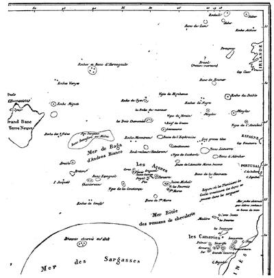
GAFFAREL’S MAP.
From a map by Gaffarel, “L’Océan Atlantique et les restes de l’Atlantide,” in the Revue de Géographie, vi. p. 400, accompanying a paper by Gaffarel in the numbers for April-July, 1880, and showing such rocks and islets as have from time to time been reported as seen, or thought to have been seen, and which Gaffarel views as vestiges of the lost continent.
We may place the beginning of the Atlantic cartography[498] in the map of Marino Sanuto in 1306, who was first of the nautical map-makers of that century to lay down the Canaries;[499] but Sanuto was by no means sure of their existence, if we may judge from his omission of them in his later maps.[500]
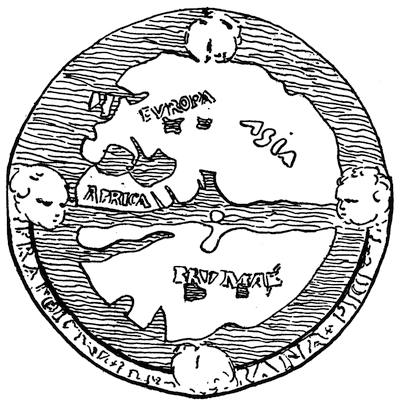
A conventional map of the older period, which is given in Santarem’s Atlas as a “Mappemonde qui se trouve au revers d’une Médaille du Commencement du XVe Siècle.”
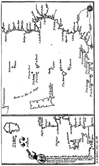
Note.—The above maps are reduced a little from the engraving in Allgemeine Geographische Ephemeriden (Weimar, 1807), vol. xxiv. p. 248. The smaller is an extract from that of Fr. Pizigani (1367), and the larger that of Andreas Bianco (1436). There is another fac-simile of the latter in F. M. Erizzo’s Le Scoperte Artiche (Venice, 1855).
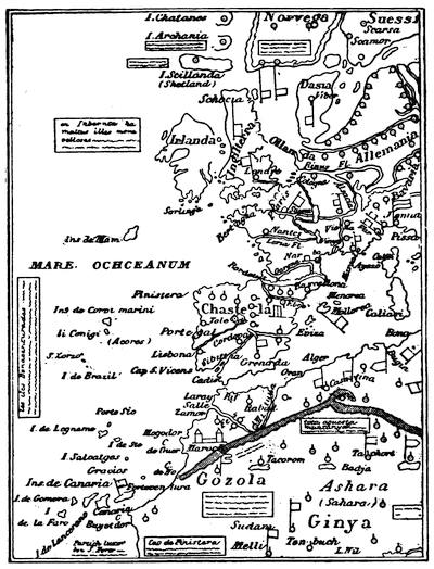
CATALAN MAP, 1375.
After a sketch in St. Martin’s Atlas, pl. vii.
There are two maps of Hygden (a.d. 1350), but the abundance of islands which they present can hardly be said to show more than a theory.[501] There is more likelihood of well considered work in the Portolano Laurenziano-Gaddiano (a.d. 1351), preserved in the Biblioteca Mediceo-Laurenziana at Florence, of which Ongania, of Venice, published a fac-simile in 1881.[502] There are two maps of Francisco Pizigani, which seem to give the Canaries, Madeira, and the Azores better than any earlier one. One of these maps (1367) is in the national library at Parma, and the other (1373) is in the Ambrosian library at Milan (Studi biog. e bibliog., vol. ii. pp. viii, 57, 58). The 1367 map is given by Jomard and Santarem. The most famous of all these early maps is the Catalan Mappemonde of 1375, preserved in the great library at Paris. It gives the Canaries and other islands further north, but does not reach to the Azores.[503] These last islands are included, however, in another Catalan planisphere of not far from the same era, which is preserved in the national library at Florence, and has been reproduced by Ongania (1881).[504] The student will need to compare other maps of the fourteenth century, which can be found mentioned in the Studi, etc., with references in the Kohl Maps, sect. 1. The phototypic series of Ongania is the most important contribution to this study, though the yellow tints of the original too often render the details obscurely.[505] So for the next century there are the same guides; but a number of conspicuous charts may well be mentioned. Chief among them are those of Andrea Bianco contained in the Atlas (1436), in the Biblioteca Marciana at Venice, published by Ongania (1871), who also published (1881) the Carta Nautica of Bianco, in the Biblioteca Ambrosiana in Milan.[506]
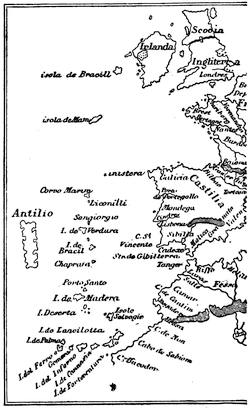
ANDREAS BENINCASA, 1476.
After a sketch in St. Martin’s Atlas, pl. vii.
The 1436 map has been reproduced in colors in Pietro Amat de San Filippo’s Planisferio disegnato del 1436 (Bollettino Soc. Geografia, 1879, p. 560); and a sketch of the Atlantic part is given in the Allgem. Geog. Ephemeriden, xxiv. no. 248.[507]
During the next twenty years or more, the varying knowledge of the Atlantic is shown in a number of maps, a few of which may be named:—The Catalan map “de Gabriell de Valsequa, faite à Mallorcha en 1439,” which shows the Azores, and which Vespucius is said to have owned (Santarem, pl. 54). The planisphere “in lingua latina dell’ anno 1447,” in the national library at Florence (Ongania, 1881). The world maps of Giovanni Leardo (Johannes Leardus), 1448 and 1452, the former of which is given in Santarem (pl. 25,—also Hist. Cartog. iii. 398), and the latter reproduced by Ongania, 1880. One is in the Ambrosian library, and the other in the Museo Civico at Vicenza (cf. Studi, etc., ii. 72, 73). In the Biblioteca Vittorio Emanuele at Rome there is the sea-chart of Bartolomaeus de Pareto of 1455, on which we find laid down the Fortunate Islands, St. Brandan’s, Antillia, and Royllo.[508] The World of Fra Mauro[509] has been referred to elsewhere in the present volume.
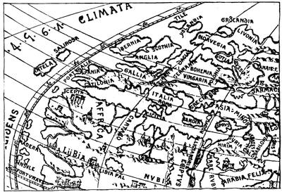
LAON GLOBE.
From a “projection Synoptique Cordiforme” in the Bull. de la Soc. de Géog., 4e série, xx. (1860), in connection with a paper by D’Avezac (p. 398). Cf. Oscar Peschel in Ausland May 12, 1861; also in his Abhandlungen, i. 226.
We come now to the conditions of the Atlantic cartography immediately preceding the voyage of Columbus. The most prominent specimens of this period are the various marine charts of Grogioso and Andreas Benincasa from 1461 to 1490. Some of these are given by Santarem, Lelewel, and St. Martin; but the best enumeration of them is given in the Studi biog. e bibliog. della Soc. Geog. Ital. ii. 66, 77-84, 92, 99, 100. Of Toscanelli’s map of 1474, which influenced Columbus, we have no sketch, though some attempts have been made to reconstruct it from descriptions. (Cf. Vol. II. p. 103; Harrisse’s Christophe Colomb., i. 127, 129.) Brief mention may also be made of the Laon globe of 1486 (dated 1493), of which D’Avezac gives a projection in the Bulletin de la Soc. de Géog. xx. 417; of the Majorcan (Catalan) Carta nautica of about 1487 (cf. Studi, etc., ii. no. 397; Bull. Soc. Géog., i. 295); of the chart in the Egerton MSS., Brit. Mus., made by Christofalo Soligo about the same time, and which has no dearth of islands (cf. Studi, etc., i. 89); of those of Nicola Fiorin, Canepa, and Giacomo Bertran (Studi, etc., ii. 82, 86, and no. 398). The globe of Behaim (1492) gives the very latest of these ante-Columbian views (see Vol. II. 105).
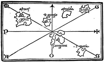
A Fac-simile from BORDONE, 1547.
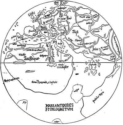
END OF FIFTEENTH CENTURY. (Santarem’s Atlas.)
It took, after this, a long time for the Atlantic to be cleared, even partially, of these intrusive islands, and to bring the proper ones into accurate relations. How the old ideas survived may be traced in the maps of Ruysch, 1508 (Vol. II. 115); Coppo, 1528, with its riot of islands (II. 127); Mercator, 1541 (II. 177); Bordone, 1547; Zaltière, 1566 (II. 451); Porcacchi, 1572 (II. 453); Ortelius, 1575, 1587,—not to continue the series further.
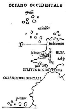
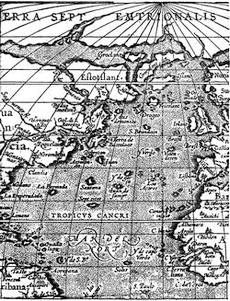
NOTE.—The left of the annexed cuts is from Bordone’s Isolario, 1547; the right one is an extract from the “World” of Ortelius, 1587.