Front matter (continued 10)
Reading edition
1904. Ft. 1905. Ft.
United Kingdom 7,498,301 13,690,869
South America 15,647,808 13.332,993
Australia 10,045,094 11,596,482
South Africa 2,517,154 7,093,681
China and Japan 4,802,426 4,787,784
Germany 983,342
Fiji Islands 308,332 29,949
France 1,308,662
————— —————
42,199,777 51,515,100
There is a very large market for British Columbia lumber in the western provinces of Canada.
Agriculture.—Although mountainous in character the province contains many tracts of good farming land. These lie in the long valleys between the mountain ranges of the interior, as well as on the lower slopes of the mountains and on the deltas of the rivers running out to the coast. On Vancouver Island also there is much good farming land. The conditions are in most places best suited to mixed farming; the chief crops raised are wheat, oats, potatoes and hay. Some areas are especially suited for cattle and sheep raising, among which may be mentioned the Yale district and the country about Kamloops. Much attention has been given to fruit raising, especially in the Okanagan valley. Apples, plums and cherries are grown, as well as peaches, apricots, grapes and various small fruits, notably strawberries. All these are of excellent quality. Hops are also cultivated. A large market for this fruit is opening up in the rapidly growing provinces of Alberta and Saskatchewan.
Imports and Exports.—For the year ending June 30th 1905 the total exports and imports (showing a slight gradual increase on the two preceding years) were valued at $16,677,882 and $12,565,019 respectively. The exports were classified as follows:—Mines, $9,777,423; fisheries, $2,101,533; forests, $1,046,718; animals, $471,231; agriculture, $119,426; manufactures, $1,883,777; miscellaneous, $1,106,643; coin and bullion, $171,131.
Railways.—The Pacific division of the Canadian Pacific railway enters British Columbia through the Rocky Mountains on the east and runs for about 500 m. across the province before reaching the terminus at Vancouver. A branch of the same railway leaves the main line at Medicine Hat, and running to the south-west, crosses the Rocky Mountains through the Crow's Nest Pass, and thus enters British Columbia a short distance north of the United States boundary. This continues across the province, running approximately parallel to the boundary as far as Midway in what is known as the Boundary district. The line has opened up extensive coal fields and crosses a productive mining district. On Vancouver Island there are two railways, the Esquimalt & Nanaimo railway (78 m.) connecting the coal fields with the southern ports, and the Victoria & Sydney railway, about 16 m. in length. The Great Northern has also a number of short lines in the southern portion of the province, connecting with its system in the United States. In 1905 there were 1627m. of railway in the province, of which 1187 were owned or controlled by the Canadian Pacific railway.
Shipping.—The Canadian Pacific Railway Company has two lines of mail steamer running from Vancouver and Victoria: (l) the Empress line, which runs to Japan and China once in three weeks, and (2) the Australian line to Honolulu, Fiji and Sydney, once a month. The same company also has a line of steamers running to Alaska, as well as a fleet of coasting steamers.
Government.—The province is governed by a lieutenant-governor, appointed by the governor-general in council for five years, but subject to removal for cause, an executive council of five ministers, and a single legislative chamber. The executive council is appointed by the lieutenant-governor on the advice of the first minister, and retains office so long as it enjoys the support of a majority of the legislature. The powers of the lieutenant-governor in regard to the provincial government are analogous to those of governor-general in respect of the dominion government.
The British North America Act (1867) confederating the colonies, defines the jurisdiction of the provincial legislature as distinguished from that of the federal parliament, but within its own jurisdiction the province makes the laws for its own governance. The act of the legislature may be disallowed, within one year of its passage, by the governor-general in council, and is also subject to challenge as to its legality in the supreme court of Canada or on appeal to the juridical committee of the privy council of the United Kingdom. British Columbia sends three senators and seven members to the lower house of the federal parliament, which sits at Ottawa.
Justice.—There is a supreme court of British Columbia presided over by a chief justice and five puisne judges, and there are also a number of county courts. In British Columbia the supreme court has jurisdiction in divorce cases, this right having been invested in the colony before confederation.
Religion and Education.—In 1901 the population was divided by creeds as follows: Church of England, 40,687; Methodist, 25,047; Presbyterian, 34,081; Roman Catholic, 33,639; others, 40,197; not stated, 5003; total, 178,654. The educational system of British Columbia differs slightly from that of other provinces of Canada. There are three classes of schools—common, graded and high—all maintained by the government and all free and undenominational. There is only one college in the province, the "McGill University College of British Columbia" at Vancouver, which is one of the colleges of McGill University, whose chief seat is at Montreal. The schools are controlled by trustees selected by the ratepayers of each school district, and there is a superintendent of education acting under the provincial secretary.
Finance.—Under the terms of union with Canada, British Columbia receives from the dominion government annually a certain contribution, which in 1905 amounted to $307,076. This, with provincial taxes on real property, personal property, income tax, sales of public land, timber dues, &c., amounted in the year 1905 to $2,920,461. The expenditure for the year was $2,302,417. The gross debt of the province in 1905 was $13,252,097, with assets of $4,463,869, or a net debt of $8,788,228. These assets do not include new legislative buildings or other public works. The income tax is on a sliding scale. In 1899 a fairly close estimate was made of the capital invested in the province, which amounted to $307,385,000 including timber, $100,000,000; railways and telegraphs, $47,500,000; mining plant and smelters, $10,500,000; municipal assessments, $45,000,000; provincial assessments, $51,500,000; in addition to private wealth, $280,000,000. There are branch offices of one or more of the Canadian banks in each of the larger towns.
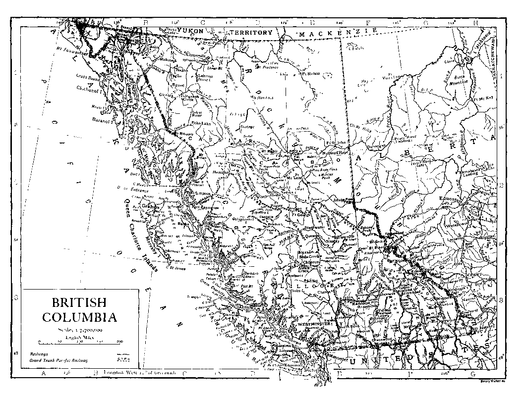
History.—The discovery of British Columbia was made by the Spaniard Perez in 1774. With Cook's visit the geographical exploration of the coast began in 1778. Vancouver, in 1792-1794, surveyed almost the entire coast of British Columbia with much of that to the north and south, for the British government. The interior, about the same time, was entered by Mackenzie and traders of the N.W. Company, which in 1821 became amalgamated with the Hudson's Bay Company. For the next twenty-eight years the Hudson's Bay Company ruled this immense territory with beneficent despotism. In 1849 Vancouver Island was proclaimed a British colony. In 1858, consequent on the discovery of gold and the large influx of miners, the mainland territory was erected into a colony under the name of British Columbia, and in 1866 this was united with the colony of Vancouver Island, under the same name. In 1871 British Columbia entered the confederation and became part of the Dominion of Canada, sending three senators and six (now seven) members to the House of Commons of the federal parliament. One of the conditions under which the colony entered the dominion was the speedy construction of the Canadian Pacific railway, and in 1876 the non-fulfilment of this promise and the apparent indifference of the government at Ottawa to the representations of British Columbia created strained relations, which were only ameliorated when the construction of a transcontinental road was begun. In subsequent years the founding of the city of Vancouver by the C.P.R., the establishment of the first Canadian steamship line to China and Japan, and that to Australia, together with the disputes with the United States on the subject of pelagic sealing, and the discovery of the Kootenay and Boundary mining districts, have been the chief events in the history of the province.
Authorities.—Cook's Voyage to the Pacific Ocean (London, 1784); Vancouver, Voyage of Discovery to the Pacific Ocean (London, 1798); H.H. Bancroft's works, vol. xxxii., History of British Columbia (San Francisco, 1887); Begg's History of British Columbia (Toronto, 1894); Gosnell, Year Book (Victoria, British Columbia, 1897 and 1903); Annual Reports British Columbia Board of Trade (Victoria); Annual Reports of Minister of Mines and other Departmental Reports of the Provincial and Dominion Governments; Catalogue of Provincial Museum (Victoria); Reports Geological Survey of Canada (from 1871 to date); Reports of Canadian Pacific (Government) Surveys (1872-1880); Reports of Committee of Brit. Assn. Adv. Science on N.W. Tribes (1884-1895); Lord, Naturalist in Vancouver Island (London, 1866); Bering Sea Arbitration (reprint of letters to Times), (London, 1893); Report of Bering Sea Commission (London, Government, 1892); A. Métin, La Colombie Britannique (Paris, 1908). See also various works of reference under Canada.
(G. M. D.; M. St J.; F. D. A.)
BRITISH EAST AFRICA, a term, in its widest sense, including all the territory under British influence on the eastern side of Africa between German East Africa on the south and Abyssinia and the Anglo-Egyptian Sudan on the north. It comprises the protectorates of Zanzibar, Uganda and East Africa. Apart from a narrow belt of coastland, the continental area belongs almost entirely to the great plateau of East Africa, rarely falling below an elevation of 2000 ft., while extensive sections rise to a height of 6000 to 8000 ft. From the coast lowlands a series of steps with intervening plateaus leads to a broad zone of high ground remarkable for the abundant traces of volcanic action. This broad upland is furrowed by the eastern "rift-valley," formed by the subsidence of its floor and occupied in parts by lakes without outlet. Towards the west a basin of lower elevation is partially occupied by Victoria Nyanza, drained north to the Nile, while still farther inland the ground again rises to a second volcanic belt, culminating in the Ruwenzori range. (See Zanzibar, and for Uganda protectorate see Uganda.) The present article treats of the East Africa protectorate only.
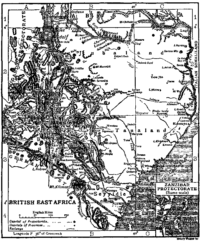
Topography.—The southern frontier, coterminous with the northern frontier of German East Africa, runs north-west from the mouth of the Umba river in 4° 40′ S. to Victoria Nyanza, which it strikes at 1° S., deviating, however, so as to leave Mount Kilimanjaro wholly in German territory. The eastern boundary is the Indian Ocean, the coast line being about 400 m. On the north the protectorate is bounded by Abyssinia and Italian Somaliland; on the west by Uganda. It has an area of about 240,000 sq. m., and a population estimated at from 2,000,000 to 4,000,000, including some 25,000 Indians and 3000 Europeans. Of the Europeans many are emigrants from South Africa; they include some hundreds of Boer families.
The first of the parallel zones—the coast plain or "Temborari"—is generally of insignificant width, varying from 2 to 10 m., except in the valleys of the main rivers. The shore line is broken by bays and branching creeks, often cutting off islands from the mainland. Such are Mvita or Mombasa in 4° 4′ S., and the larger islands of Lamu, Manda and Patta (the Lamu archipelago), between 2° 20′ and 2° S. Farther north the coast becomes straighter, with the one indentation of Port Durnford in 1° 10′ S., but skirted seawards by a row of small islands. Beyond the coast plain the country rises in a generally well defined step or steps to an altitude of some 800 ft., forming the wide level plain called "Nyika" (uplands), largely composed of quartz. It contains large waterless areas, such as the Taru desert in the Mombasa district. The next stage in the ascent is marked by an intermittent line of mountains—gneissose or schistose—running generally north-north-west, sometimes in parallel chains, and representing the primitive axis of the continent. Their height varies from 5000 to 8000 ft. Farther inland grassy uplands extend to the eastern edge of the rift-valley, though varied with cultivated ground and forest, the former especially in Kikuyu, the latter between 0° and 0° 40′ S. The most extensive grassy plains are those of Kapte or Kapote and Athi, between 1° and 2° S. The general altitude of these uplands, the surface of which is largely composed of lava, varies from 5000 to 8000 ft. This zone contains the highest elevations in British East Africa, including the volcanic pile of Kenya (q.v.) (17,007 ft.), Sattima (13,214 ft.) and Nandarua (about 12,900 ft.). The Sattima (Settima) range, or Aberdare Mountains, has a general elevation of fully 10,000 ft. To the west the fall to the rift-valley is marked by a line of cliffs, of which the best-defined portions are the Kikuyu escarpment (8000 ft.), just south of 1° S., and the Laikipia escarpment, on the equator. One of the main watersheds of East Africa runs close to the eastern wall of the rift-valley, separating the basins of inland drainage from the rivers of the east coast, of which the two largest wholly within British East Africa are the Sabaki and Tana, both separately noticed. The Guaso Nyiro rises in the hills north-west of Kenya and flows in a north-east direction. After a course of over 350 m. the river in about 1° N., 39° 30′ E. is lost in a marshy expanse known as the Lorian Swamp.
The rift-valley, though with a generally level floor, is divided by transverse ridges into a series of basins, each containing a lake without outlet. The southernmost section within British East Africa is formed by the arid Dogilani plains, drained south towards German territory. At their north end rise the extinct volcanoes of Suswa (7800 ft.) and Longonot (8700), the latter on the ridge dividing off the next basin—that of Lake Naivasha. This is a small fresh-water lake, 6135 ft. above the sea, measuring some 13 m each way. Its basin is closed to the north by the ridge of Mount Buru, beyond which is the basin of the still smaller Lakes Nakuro (5845 ft.) and Elmenteita (5860 ft.), followed in turn by that of Lakes Hannington and Baringo (q.v.). Beyond Baringo the valley is drained north into Lake Sugota, in 2° N., some 35 m. long, while north of this lies the much larger Lake Rudolf (q.v.), the valley becoming here somewhat less defined.
On the west of the rift-valley the wall of cliffs is best marked between the equator and 1° S., where it is known as the Mau Escarpment, and about 1° N., where the Elgeyo Escarpment falls to a longitudinal valley separated from Lake Baringo by the ridge of Kamasia. Opposite Lake Naivasha the Mau Escarpment is over 8000 ft. high. Its crest is covered with a vast forest. To the south the woods become more open, and the plateau falls to an open country drained towards the Dogilani plains. On the west the cultivated districts of Sotik and Lumbwa, broken by wooded heights, fall towards Victoria Nyanza. The Mau plateau reaches a height of 9000 ft. on the equator, north of which is the somewhat lower Nandi country, well watered and partly forested. In the treeless plateau of Uasin Gishu, west of Elgeyo, the land again rises to a height of over 8000 ft., and to the west of this is the great mountain mass of Elgon (q.v.). East of Lake Rudolf and south of Lake Stefanie is a large waterless steppe, mainly volcanic in character, from which rise mountain ranges. The highest peak is Mount Kanjora, 6900 ft. high. South of this arid region, strewn with great lava stones, are the Rendile uplands, affording pasturage for thousands of camels. Running north-west and south-east between Lake Stefanie and the Daua tributary of the Juba is a mountain range with a steep escarpment towards the south. It is known as the Goro Escarpment, and at its eastern end it forms the boundary between the protectorate and Abyssinia. South-east of it the country is largely level bush covered plain, mainly waterless.
[Geology.—The geological formations of British East Africa occur in four regions possessing distinct physiographical features. The coast plain, narrow in the south and rising somewhat steeply, consists of recent rocks. The foot plateau which succeeds is composed of sedimentary rocks dating from Trias to Jurassic. The ancient plateau commencing at Taru extends to the borders of Kikuyu and is composed of ancient crystalline rocks on which immense quantities of volcanic rocks—post-Jurassic to Recent—have accumulated to form the volcanic plateau of Central East Africa.
The formations recognized are given in the following table:—
Sedimentary.
Recent 1. Alluvium and superficial sands.

2. Modern lake deposits, living coral rock.
3. Raised coral rock, conglomerate of Mombasa Island.
Pleistocene 4. Gravels with flint implements.
5. Glacial beds of Kenya
Jurassic 6. Shales and limestones of Changamwe.
Karroo 7. Flags and sandstones.
8. Grits and shales of Masara and Taru.
Carboniferous? 9. Shales of the Sabaki river.
Archaean 10. Schists and quartzites of Nandi.
11. Gneisses, schists, granites.
Igneous and Volcanic.
Recent Active, dormant and extinct volcanoes.
Post-Jurassic to Pleistocene Kibo and volcanoes of the rift-valley.
Kimawenzi, Kenya and plateau eruptions.
Archaean.—These rocks prevail in the districts of Taru, Nandi and throughout Ukamba. A course gneiss is the predominant rock, but is associated with garnetiferous mica-schists and much intrusive granite. Hornblende schists and beds of metamorphic limestone are rare. Cherty quartzites interbedded with mylonites occur on the flanks of the Nandi hills, but their age is not known.
Carboniferous?—From shales on the Sabaki river Dr Gregory obtained fish-scales and specimens of Palaeanodonta Fischeri.
Karroo.—The grits of Masara, near Rabai mission station and Mombasa, have yielded specimens of Glossopteris browniana var. indica, thus indicating their Karroo age.
Jurassic.—Shales and limestones of this age are well seen along the railway near Changamwe. They contain gigantic ammonites. According to Dr Waagen the ammonites show a striking analogy to forms from the Acanthicus zone of East India. Belemnites are plentiful.
Pleistocene.—These are feebly represented by some boulder beds on the higher slopes of Kilimanjaro and Kenya. They show that in Pleistocene times the glaciers of Kilimanjaro and Kenya extended much farther down the mountain slopes.
Recent.—The ancient and more modern lake deposits have so far yielded no mammalian or other organic remains of interest.
Igneous and Volcanic.—A belt of volcanic rocks, over 150,000 sq. m. in area, extends from beyond the southern to beyond the northern territorial limits. They belong to an older and a newer set. The older group commenced with a series of fissure eruptions along the site of the present rift-valley and parallel with it. From these fissures immense and repeated flows of lava spread over the Kapte and Laikipia plateaus. At about the same time, or a little later, Kenya and Kimawenzi, Elgon and Chibcharagnani were in eruption. The age of these volcanic outbursts cannot be more definitely stated than that they are post-Jurassic, and probably extended through Cretaceous into early Tertiary times. This great volcanic period was followed by the eruptions of Kibo and some of the larger volcanoes of the rift-valley. The flows from Kibo include nepheline and leucite basanite lavas rich in soda felspars. They bear a close resemblance to the Norwegian "Rhombenporphyrs." The chain of volcanic cones along the northern lower slopes of Kilimanjaro, those of the Kyulu mountains, Donyo Longonot and numerous craters in the rift-valley region, are of a slightly more recent date. A few of the volcanoes in the latter region have only recently become extinct; a few may be only dormant. Donyo Buru still emits small quantities of steam, while Mount Teleki, in the neighbourhood of Lake Rudolf, was in eruption at the close of the 19th century.]
Climate, Flora and Fauna.—In its climate and vegetation British East Africa again shows an arrangement of zones parallel to the coast. The coast region is hot but is generally more healthy than the coast lands of other tropical countries, this being due to the constant breeze from the Indian Ocean and to the dryness of the soil. The rainfall on the coast is about 35 in. a year, the temperature tropical. The succeeding plains and the outer plateaus are more arid. Farther inland the highlands—in which term may be included all districts over 5000 ft. high—are very healthy, fever being almost unknown. The average temperature is about 66° F. in the cool season and 73° F. in the hot season. Over 7000 ft. the climate becomes distinctly colder and frosts are experienced. The average rainfall in the highlands is between 40 and 50 in. The country bordering Victoria Nyanza is typically tropical; the rainfall exceeds 60 in. in the year, and this region is quite unsuitable to Europeans. The hottest period throughout the protectorate is December to April, the coolest, July to September. The "greater rains" fall from March to June, the "smaller rains" in November and December. The rainfall is not, however, as regular as is usual in countries within the tropics, and severe droughts are occasionally experienced.
In the districts bordering Victoria Nyanza the flora resembles that of Uganda (q.v.). The characteristic trees of the coast regions are the mangrove and coco-nut palm. Ebony grows in the scrub-jungle. Vast forests of olives and junipers are found on the Mau escarpment; the cotton, fig and bamboo on the Kikuyu escarpment; and in several regions are dense forests of great trees whose lowest branches are 50 ft. from the ground. Two varieties of the valuable rubber-vine, Landolphia florida and Landolphia Kirkii, are found near the coast and in the forests. The higher mountains preserve distinct species, the surviving remnants of the flora of a cooler period.
The fauna is not abundant except in large mammals, which are very numerous on the drier steppes. They include the camel (confined to the arid northern regions), elephant (more and more restricted to unfrequented districts), rhinoceros, buffalo, many kinds of antelope, zebra, giraffe, hippopotamus, lion and other carnivora, and numerous monkeys. In many parts the rhinoceros is particularly abundant and dangerous. Crocodiles are common in the larger rivers and in Victoria Nyanza. Snakes are somewhat rare, the most dangerous being the puff-adder. Centipedes and scorpions, as well as mosquitoes and other insects, are also less common than in most tropical countries. In some districts bees are exceedingly numerous. The birds include the ostrich, stork, bustard and secretary-bird among the larger varieties, the guinea fowl, various kinds of spur fowl, and the lesser bustard, the wild pigeon, weaver and hornbill. By the banks of lakes and rivers are to be seen thousands of cranes, pelicans and flamingoes.
Inhabitants.—The white population is chiefly in the Kikuyu uplands, the rift-valley, and in the Kenya region. The whites are mostly agriculturists. There are also numbers of Indian settlers in the same districts. The African races include representatives of various stocks, as the country forms a borderland between the Negro and Hamitic peoples, and contains many tribes of doubtful affinities. The Bantu division of the negroes is represented chiefly in the south, the principal tribes being the Wakamba, Wakikuyu and Wanyika. By the north-east shores of Victoria Nyanza dwell the Kavirondo (q.v.), a race remarkable among the tribes of the protectorate for their nudity. Nilotic tribes, including the Nandi (q.v.), Lumbwa, Suk and Turkana, are found in the north-west. Of Hamitic strain are the Masai (q.v.), a race of cattle-rearers speaking a Nilotic language, who occupy part of the uplands bordering on the eastern rift-valley. A branch of the Masai which has adopted the settled life of agriculturists is known as the Wakuafi. The Galla section of the Hamites is represented, among others, by Borani living south of the Goro Escarpment (though the true Boran countries are Liban and Dirri in Abyssinian territory), while Somali occupy the country between the Tana and Juba rivers. Of the Somali tribes the Herti dwell near the coast and are more or less stationary. Further inland is the nomadic tribe of Ogaden Somali. The Gurre, another Somali tribe, occupy the country south of the lower Daua. Primitive hunting tribes are the Wandorobo in Masailand, and scattered tribes of small stature in various parts. The coast-land contains a mixed population of Swahili, Arab and Indian immigrants, and representatives of numerous interior tribes.
Provinces and Towns.—The protectorate has been divided into the provinces of Seyyidie (the south coast province, capital Mombasa); Ukamba, which occupies the centre of the protectorate (capital Nairobi); Kenya, the district of Mt. Kenya (capital Fort Hall); Tanaland, to the north of the two provinces first named (capital Lamu); Jubaland, the northern region (capital Kismayu); Naivasha (capital Naivasha); and Kisumu (capital Kisumu); each being in turn divided into districts and sub-districts. Naivasha and Kisumu, which adjoin the Victoria Nyanza, formed at first the eastern province of Uganda, but were transferred to the East Africa protectorate on the 1st of April 1902. The chief port of the protectorate is Mombasa (q.v.) with a population of about 30,000. The harbour on the south-west side of Mombasa island is known as Kilindini, the terminus of the Uganda railway. On the mainland, nearly opposite Mombasa town, is the settlement of freed slaves named Freretown, after Sir Bartle Frere. Freretown (called by the natives Kisaoni) is the headquarters in East Africa of the Church Missionary Society. It is the residence of the bishop of the diocese of Mombasa and possesses a fine church and mission house. Lamu, on the island of the same name, 150 m. north-east of Mombasa, is an ancient settlement and the headquarters of the coast Arabs. Here are some Portuguese ruins, and a large Arab city is buried beneath the sands. The other towns of note on the coast are Malindi, Patta, Kipini and Kismayu. At Malindi, the "Melind" of Paradise Lost, is the pillar erected by Vasco da Gama when he visited the port in 1498. The harbour is very shallow. Kismayu, the northernmost port of the protectorate, 320 m. north-east of Mombasa, is the last sheltered anchorage on the east coast and is invaluable as a harbour of refuge. Flourishing towns have grown up along the Uganda railway. The most important, Nairobi (q.v.), 327 m. from Mombasa, 257 from Port Florence, was chosen in 1907 as the administrative capital of the protectorate. Naivasha, 64 m. north-north-west of Nairobi, lies in the rift-valley close to Lake Naivasha, and is 6230 ft. above the sea. It enjoys an excellent climate and is the centre of a European agricultural settlement. Kisumu or Port Florence (a term confined to the harbour) is a flourishing town built on a hill overlooking Victoria Nyanza. It is the entrepôt for the trade of Uganda.
Communications.—Much has been done to open up the country by means of roads, including a trunk road from Mombasa, by Kibwezi in the upper Sabaki basin, and Lake Naivasha, to Berkeley Bay on Victoria Nyanza. But the most important engineering work undertaken in the protectorate was the construction of a railway from Mombasa to Victoria Nyanza, for which a preliminary survey was executed in 1892, and on which work was begun in 1896. The line chosen roughly coincides with that of the road, until the equator is reached, after which it strikes by a more direct route across the Mau plateau to the lake, which it reaches at Port Florence on Kavirondo Gulf. The railway is 584 m. long and is of metre (3.28 ft.) gauge, the Sudan, and South and Central African lines being of 3 ft. 6 in. gauge. The Uganda railway is essentially a mountain line, with gradients of one in fifty and one in sixty. From Mombasa it crosses to the mainland by a bridge half a mile long, and ascends the plateau till it reaches the edge of the rift-valley, 346 m. from its starting point, at the Kikuyu Escarpment, where it is 7600 ft. above the sea. It then descends across ravines bridged by viaducts to the valley floor, dropping to a level of 6011 ft., and next ascending the opposite (Mau) escarpment to the summit, 8321 ft. above sea-level—the highest point on the line. In the remaining 100 m. of its course the level sinks to 3738 ft., the altitude of the station at Port Florence. The railway was built by the British government at a cost of £5,331,000, or about £9500 per mile. The first locomotive reached Victoria Nyanza on the 26th of December 1901; and the permanent way was practically completed by March 1903, when Sir George Whitehouse, the engineer who had been in charge of the construction from the beginning, resigned his post. The railway, by doing away with the carriage of goods by men, gave the final death-blow to the slave trade in that part of East Africa. It also facilitated the continued occupation and development of Uganda, which was, previous to its construction, an almost impossible task, owing to the prohibitive cost of the carriage of goods from the coast—£60 per ton. The two avowed objects of the railway—the destruction of the slave trade and the securing of the British position in Uganda—have been attained; moreover, the railway by opening up land suitable for European settlement has also done much towards making a prosperous colony of the protectorate, which was regarded before the advent of the line as little better than a desert (see below, History). The railway also shows a fair return on the capital expenditure, the surplus after defraying all working expenses being £56,000 in 1905-1906 and £76,000 in 1906-1907.
Mombasa is visited by the boats of several steamship companies, the German East Africa line maintaining a fortnightly service from Hamburg. There is also a regular service to and from India. A cable connecting Mombasa with Zanzibar puts the protectorate in direct telegraphic communication with the rest of the world. There is also an inland system of telegraphs connecting the chief towns with one another and with Uganda.
Agriculture and other Industries.—In the coast region and by the shores of Victoria Nyanza the products are tropical, and cultivation is mainly in the hands of the natives or of Indian immigrants. There are, however, numerous plantations owned by Europeans. Rice, maize and other grains are raised in large quantities; cotton and tobacco are cultivated. The coco-nut palm plantations yield copra of excellent quality, and the bark of the mangrove trees is exported for tanning purposes. In some inland districts beans of the castor oil plant, which grows in great abundance, are a lucrative article of trade. The sugar-cane, which grows freely in various places, is cultivated by the natives. The collection of rubber likewise employs numbers of people.
Among the European settlers in the higher regions much attention is devoted to the production of vegetables, and very large crops of potatoes are raised. Oats, barley, wheat and coffee are also grown. The uplands are peculiarly adapted for the raising of stock, and many of the white settlers possess large flocks and herds. Merino sheep have been introduced from Australia. Ostrich farms have also been established. Clover, lucerne, ryegrass and similar grasses have been introduced to improve and vary the fodder. Other vegetable products of economic value are many varieties of timber trees, and fibre-producing plants, which are abundant in the scrub regions between the coast and the higher land bordering the rift-valley. Over the greater part of the country the soil is light reddish loam; in the eastern plains it is a heavy black loam. As a rule it is easily cultivated. While the majority of the African tribes in the territory are not averse from agricultural labour, the number of men available for work on European holdings is small. Moreover, on some of the land most suited for cultivation by white men there is no native population.
In addition to the fibre industry and cotton ginning there are factories for the curing of bacon. Native industries include the weaving of cloth and the making of mats and baskets. Stone and lime quarries are worked, and copper is found in the Tsavo district. Diamonds have been discovered in the Thika river, one of the headstreams of the Tana.
Trade.—The imports consist largely of textiles, hardware and manufactured goods from India and Europe; Great Britain and India between them supplying over 50% of the total imports. Of other countries Germany has the leading share in the trade. The exports, which include the larger part of the external trade of Uganda, are chiefly copra, hides and skins, grains, potatoes, rubber, ivory, chillies, beeswax, cotton and fibre. The retail trade is largely in the hands of Indians. The value of the exports rose from £89,858 in 1900-1901 to £234,664 in 1904-1905, in which year the value of the imports for the first time exceeded £500,000. In 1906-1907 the volume of trade was £1,194,352, imports being valued at £753,647 and exports at £440,705. The United States takes 33% of the exports, Great Britain coming next with 15%.
Government.—The system of government resembles that of a British crown colony. At the head of the administration is a governor, who has a deputy styled lieutenant-governor, provincial commissioners presiding over each province. There are also executive and legislative councils, unofficial nominated members serving on the last-named council. In the "ten-mile strip" (see below, History), the sultan of Zanzibar being territorial sovereign, the laws of Islam apply to the native and Arab population. The extra-territorial jurisdiction granted by the sultan to various Powers was in 1907 transferred to Great Britain. Domestic slavery formerly existed; but on the advice of the British government a decree was issued by the sultan on the 1st of August 1890, enacting that no one born after that date could be a slave, and this was followed in 1907 by a decree abolishing the legal status of slavery. In the rest of the protectorate slavery is not recognized in any form. Legislation is by ordinances made by the governor, with the assent of the legislative council. The judicial system is based on Indian models, though in cases in which Africans are concerned regard is had to native customs. Europeans have the right to trial by jury in serious cases. There is a police force of about 2000 men, and two battalions of the King's African Rifles are stationed in the protectorate. Revenue is derived chiefly from customs, licences and excise, railway earnings, and posts and telegraphs. Natives pay a hut tax. Since the completion of the Uganda railway, trade, and consequently revenue, has increased greatly. In 1900-1901 the revenue was £64,275 and the expenditure £193,438; in 1904-1905 the figures were: revenue £154,756, expenditure £302,559; in 1905-1906 the totals were £270,362 and £418,839, and in 1906-1907 (when the railway figures were included for the first time) £461,362 and £616,088. The deficiencies were made good by grants-in-aid from the imperial exchequer. The standard coin used is the rupee (16d.).
Education is chiefly in the hands of the missionary societies, which maintain many schools where instruction is given in handicrafts, as well as in the ordinary branches of elementary education. There are Arab schools in Mombasa, and government schools for Europeans and Indians at Nairobi.
History.—From the 8th century to the 11th Arabs and Persians made settlements along the coast and gained political supremacy at many places, leading to the formation of the so-called Zenj empire. The history of the coast towns from that time until the establishment of British rule is identified with that of Zanzibar (q.v.). The interior of what is now British East Africa was first made known in the middle of the 19th century by the German missionaries Ludwig Krapf and Johannes Rebmann, and by Baron Karl von der Decken (1833-1865) and others. Von der Decken and three other Europeans were murdered by Somali at a town called Bardera in October 1865, whilst exploring the Juba river. The countries east of Victoria Nyanza (Masailand, &c.) were, however, first traversed throughout their whole extent by the Scottish traveller Joseph Thomson (q.v.) in 1883-1884. In 1888 Count S. Teleki (a Hungarian) discovered Lakes Rudolf and Stefanie.
The growth of British interests in the country now forming the protectorate arises from its connexion with the sultanate of Zanzibar. At Zanzibar British influence was very strong in the last quarter of the 19th century, and the seyyid or sultan, Bargash, depended greatly on the advice of the British representative, Sir John Kirk. In 1877 Bargash offered to Mr (afterwards Sir) William Mackinnon (1823-1893), chairman of the British India Steam Navigation Company, a merchant in whom he had great confidence, or to a company to be formed by him, a lease for 70 years of the customs and administration of the whole of the mainland dominions of Zanzibar including, with certain reservations, rights of sovereignty. This was declined owing to a lack of support by the foreign office, and concessions obtained in 1884 by Mr (afterwards Sir) H.H. Johnston in the Kilimanjaro district were, at the time, disregarded. The large number of concessions acquired by Germans in 1884-1885 on the East African coast aroused, however, the interest of those who recognized the paramount importance of the maintenance of British influence in those regions. A British claim, ratified by an agreement with Germany in 1886, was made to the districts behind Mombasa; and in May 1887 Bargash granted to an association formed by Mackinnon a concession for the administration of so much of his mainland territory as lay outside the region which the British government had recognized as the German sphere of operations. By international agreement the mainland territories of the sultan were defined as extending 10 m. inland from the coast. Mackinnon's association, whose object A chartered company formed. was to open up the hinterland as well as this ten-mile strip, became the Imperial British East Africa Company by a founder's agreement of April 1888, and received a royal charter in September of the same year. To this company the sultan made a further concession dated October 1888. On the faith of these concessions and the charters a sum of £240,000 was subscribed, and the company received formal charge of their concessions. The path of the company was speedily beset with difficulties, which in the first instance arose out of the aggressions of the German East African Company. This company had also received a grant from the sultan in October 1888, and its appearance on the coast was followed by grave disturbances among the tribes which had welcomed the British. This outbreak led to a joint British and German blockade, which seriously hampered trade operations. It had also been anticipated, in reliance on certain assurances of Prince Bismarck, emphasized by Lord Salisbury, that German enterprise in the interior of the country would be confined to the south of Victoria Nyanza. Unfortunately this expectation was not realized. Moreover German subjects put forward claims to coast districts, notably Lamu, within the company's sphere and in many ways obstructed the company's operations. In all these disputes the German government countenanced its own subjects, while the British foreign office did little or nothing to assist the company, sometimes directly discouraging its activity. Moreover, the company had agreed by the concession of October 1888 to pay a high revenue to the sultan—Bargash had died in the preceding March and the Germans were pressing his successor to give them a grant of Lamu—in lieu of the customs collected at the ports they took over. The disturbance caused by the German claims had a detrimental effect on trade and put a considerable strain on the resources of the company. The action of the company in agreeing to onerous financial burdens was dictated partly by regard for imperial interests, which would have been seriously weakened had Lamu gone to the Germans.
By the hinterland doctrine, accepted both by Great Britain and Germany in the diplomatic correspondence of July 1887, Uganda would fall within Great Britain's "sphere of influence"; but German public opinion did not so regard the matter. German maps assigned the territory to Germany, while in England public opinion as strongly expected British influence to be paramount. In 1889 Karl Peters, a German official, led what was practically a raiding expedition into that country, after running a blockade of the ports. An expedition under F.J. Jackson had been sent by the company in the same year to Victoria Nyanza, but with instructions to avoid Uganda. In consequence of representations from Uganda, and of tidings he received of Peters's doings, Jackson, however, determined to go to that country. Peters retired at Jackson's approach, claiming, nevertheless, to have made certain treaties which constituted "effective occupation." Peters's treaty was dated the 1st of March 1890: Jackson concluded another in April. Meantime negotiations were proceeding in Europe; and by the Anglo-German agreement of the 1st of July 1890 Uganda was assigned to the British sphere. To consolidate their position in Uganda—the French missionaries there were hostile to Great Britain—the company sent thither Captain F.D. Lugard, who reached Mengo, the capital, in December 1890 and established the authority of the company despite French intrigues. In July 1890 representatives of the powers assembled at Brussels had agreed on common efforts for the suppression of the slave trade. The interference of the company in Uganda had been a material step towards that object, which they sought to further and at the same time to open up the country by the construction of a railway from Mombasa to Victoria Nyanza. But their resources being inadequate for such an undertaking they sought imperial aid. Although Lord Salisbury, then prime minister, paid the highest tribute to the company's labours, and a preliminary grant for the survey had been practically agreed upon, the scheme was wrecked in parliament. At a later date, however, the railway was built entirely at government cost (supra, § Communications). Owing to the financial strain imposed upon it the company decided to withdraw Captain Lugard and his forces in August 1891; and eventually the British government assumed a protectorate over the country (see Uganda).
Further difficulties now arose which led finally to the extinction of the company. Its pecuniary interests sustained a severe The company and the crown. blow owing to the British government—which had taken Zanzibar under its protection in November 1890—declaring (June 1892) the dominions of the sultan within the free trade zone. This act extinguished the treaties regulating all tariffs and duties with foreign powers, and gave free trade all along the coast. The result for the company was that dues were now swept away without compensation, and the company was left saddled with the payment of the rent, and with the cost, in addition, of administration, the necessary revenue for which had been derived from the dues thus abolished. Moreover, a scheme of taxation which it drew up failed to gain the approval of the foreign office.
In every direction the company's affairs had drifted into an impasse. Plantations had been taken over on the coast and worked at a loss, money had been advanced to native traders and lost, and expectations of trade had been disappointed. At this crisis Sir William Mackinnon, the guiding spirit of the company, died (June 1893). At a meeting of shareholders on the 8th of May 1894 an offer to surrender the charter to the government was approved, though not without strong protests. Negotiations dragged on for over two years, and ultimately the terms of settlement were that the government should purchase the property, rights and assets of the company in East Africa for £250,000. Although the company had proved unprofitable for the shareholders (when its accounts were wound up they disclosed a total deficit of £193,757) it had accomplished a great deal of good work and had brought under British sway not only the head waters of the upper Nile, but a rich and healthy upland region admirably adapted for European colonization. To the judgment, foresight and patriotism of Sir William Mackinnon British East Africa practically owes its foundation. Sir William and his colleagues of the company were largely animated by humanitarian motives—the desire to suppress slavery and to improve the condition of the natives. With this aim they prohibited the drink traffic, started industrial missions, built roads, and administered impartial justice. In the opinion of a later administrator (Sir C. Eliot), their work and that of their immediate successors was the greatest philanthropic achievement of the latter part of the 19th century.
On the 1st of July 1895 the formal transfer to the British crown of the territory administered by the company took place at Mombasa, the foreign office assuming responsibility for its administration. The territory, hitherto known as "Ibea," from the initials of the company, was now styled the East Africa protectorate. The small sultanate of Witu (q.v.) on the mainland opposite Lamu, from 1885 to 1890 a German protectorate, was included in the British protectorate. Coincident with the transfer of the administration to the imperial government a dispute as to the succession to a chieftainship in the Mazrui, the most important Arab family on the coast, led to a revolt which lasted ten months and involved much hard fighting. It ended in April 1896 in the flight of the rebel leaders to German territory, where they were interned. The rebellion marks an important epoch in the history of the protectorate as its suppression definitely substituted European for Arab influence. "Before the rebellion," says Sir C. Eliot, "the coast was a protected Arab state; since its suppression it has been growing into a British colony."
From 1896, when the building of the Mombasa-Victoria Nyanza railway was begun, until 1903, when the line was A white man's country. practically completed, the energies of the administration were largely absorbed in that great work, and in establishing effective control over the Masai, Somali, and other tribes. The coast lands apart, the protectorate was regarded as valuable chiefly as being the high road to Uganda. But as the railway reached the high plateaus the discovery was made that there were large areas of land—very sparsely peopled—where the climate was excellent and where the conditions were favourable to European colonization. The completion of the railway, by affording transport facilities, made it practicable to open the country to settlers. The first application for land was made in April 1902 by the East Africa Syndicate—a company in which financiers belonging to the Chartered Company of South Africa were interested—which sought a grant of 500 sq. m.; and this was followed by other applications for considerable areas, a scheme being also propounded for a large Jewish settlement.
During 1903 the arrival of hundreds of prospective settlers, chiefly from South Africa, led to the decision to entertain no more applications for large areas of land, especially as questions were raised concerning the preservation for the Masai of their rights of pasturage. In the carrying out of this policy a dispute arose between Lord Lansdowne, foreign secretary, and Sir Charles Eliot, who had been commissioner since 1900. The foreign secretary, believing himself bound by pledges given to the syndicate, decided that they should be granted the lease of the 500 sq. m. they had applied for; but after consulting officials of the protectorate then in London, he refused Sir Charles Eliot permission to conclude leases for 50 sq. m. each to two applicants from South Africa. Sir Charles thereupon resigned his post, and in a public telegram to the prime minister, dated Mombasa, the 21st of June 1904, gave as his reason:—"Lord Lansdowne ordered me to refuse grants of land to certain private persons while giving a monopoly of land on unduly advantageous terms to the East Africa Syndicate. I have refused to execute these instructions, which I consider unjust and impolitic."[1]
On the day Sir Charles sent this telegram the appointment of Sir Donald W. Stewart, the chief commissioner of Ashanti, to succeed him was announced. Sir Donald induced the Masai whose grazing rights were threatened to remove to another district, and a settlement of the land claims was arranged. An offer to the Zionist Association of land for colonization by Jews was declined in August 1905 by that body, after the receipt of a report by a commissioner sent to examine the land (6000 sq. m.) offered. Sir Donald Stewart died on the 1st of October 1905, and was succeeded by Colonel Hayes Sadler, the commissioner of Uganda. Meantime, in April 1905, the administration of the protectorate had been transferred from the foreign to the colonial office. By the close of 1905 considerably over a million acres of land had been leased or sold by the protectorate authorities—about half of it for grazing purposes. In 1907, to meet the demands of the increasing number of white inhabitants, who had formed a Colonists' Association[2] for the promotion of their interests, a legislative council was established, and on this council representatives of the settlers were given seats. The style of the chief official was also altered, "governor" being substituted for "commissioner". In the same year a scheme was drawn up for assisting the immigration of British Indians to the regions adjacent to the coast and to Victoria Nyanza, districts not suitable for settlement by Europeans.
In general the relations of the British with the tribes of the interior have been satisfactory. The Somali in Jubaland have given some trouble, but the Masai, notwithstanding their warlike reputation, accepted peaceably the control of the whites. This was due, in great measure, to the fact that at the period in question plague carried off their cattle wholesale and reduced them for years to a state of want and weakness which destroyed their warlike habits. One of the most troublesome tribes proved to be the Nandi, who occupied the southern part of the plateau west of the Mau escarpment. They repeatedly raided their less warlike neighbours and committed wholesale thefts from the railway and telegraph lines. In September 1905 an expedition was sent against them which reduced the tribe to submission in the following November; and early in 1906 the Nandi were removed into a reserve. The majority of the natives, unaccustomed to regular work, showed themselves averse from taking service under the white farmers. The inadequacy of the labour supply was an early cause of trouble to the settlers, while the labour regulations enforced led, during 1907-1908, to considerable friction between the colonists and the administration.
For several years after the establishment of the protectorate the northern region remained very little known and no attempt was made to administer the district. The natives were frequently raided by parties of Gallas and Abyssinians, and in the absence of a defined frontier Abyssinian government posts were pushed south to Lake Rudolf. The Abyssinians also made themselves masters of the Boran country. After long negotiations an agreement as to the boundary line between the lake and the river Juba was signed at Adis Ababa on the 6th of December 1907, and in 1908-1909 the frontier was delimited by an Anglo-Abyssinian commission, Major C.W. Gwynn being the chief British representative. Save for its north-eastern extremity Lake Rudolf was assigned to the British, Lake Stefanie falling to Abyssinia, while from about 4° 20′ N. the Daua to its junction with the Juba became the frontier.
Bibliography.—The most comprehensive account of the protectorate to the close of 1904, especially of its economic resources, is The East Africa Protectorate, by Sir Charles Eliot (London, 1905). The progress of the protectorate is detailed in the Reports by the governor issued annually by the British government since 1896, and in Drumkey's Year Book for East Africa (Bombay), first issued in 1908. The Précis of Information concerning the British East Africa Protectorate (issued by the War Office, London, 1901) is chiefly valuable for its historical information. The work of the Imperial British East Africa Company is concisely and authoritatively told from official documents in British East Africa or Ibea, by P.L. McDermont (new ed., London, 1895). Another book, valuable for its historical perspective, is The Foundation of British East Africa, by J.W. Gregory (London, 1901). Bishop A.R. Tucker's Eighteen Years in Uganda and East Africa (London, 1908) contains a summary of missionary labours. Of the works of explorers Through Masai Land, by Joseph Thomson (London, 1886), is specially valuable. For the northern frontier see Capt. P. Maud's report in Africa No. 13 (1904). For geology see, besides Thomson's book, The Great Rift Valley, by J.W. Gregory (London, 1896); Across an East African Glacier, by Hans Meyer (London and Leipzig, 1890); and Report relating to the Geology of the East Africa Protectorate, by H.B. Muff (Colonial Office, London, 1908). For big game and ornithology see On Safari, by A. Chapman (London, 1908). The story of the building of the Uganda railway is summarized in the Final Report of the Uganda Railway Committee, Africa, No. 11 (1904), published by the British government.
(F. R. C.)
BRITISH EMPIRE, the name now loosely given to the whole aggregate of territory, the inhabitants of which, under various forms of government, ultimately look to the British crown as the supreme head. The term "empire" is in this connexion obviously used rather for convenience than in any sense equivalent to that of the older or despotic empires of history.
The land surface of the earth is estimated to extend over about 52,500,000 sq. m. Of this area the British empire occupies Extent. nearly one-quarter, extending over an area of about 12,000,000 sq. m. By far the greater portion lies within the temperate zones, and is suitable for white settlement. The notable exceptions are the southern half of India and Burma; East, West and Central Africa; the West Indian colonies; the northern portion of Australia; New Guinea, British Borneo and that portion of North America which extends into Arctic regions. The area of the territory of the empire is divided almost equally between the southern and the northern hemispheres, the great divisions of Australasia and South Africa covering between them in the southern hemisphere 5,308,506 sq. m., while the United Kingdom, Canada and India, including the native states, cover between them in the northern hemisphere 5,271,375 sq. m. The alternation of the seasons is thus complete, one-half of the empire enjoying summer, while one-half is in winter. The division of territory between the eastern and western hemispheres is less equal, Canada occupying alone in the western hemisphere 3,653,946 sq. m., while Australasia, South Africa, India and the United Kingdom occupy together in the eastern hemisphere 6,925,975 sq. m. As a matter of fact, however, the eastern portions of Australasia border so nearly upon the western hemisphere that the distribution of day and night throughout the empire is, like the alternations of the seasons, almost complete, one-half enjoying daylight, while the other half is in darkness. These alternations of time and of seasons, combined with the variety of soils and climates, are calculated to have an increasingly important effect upon the material and industrial, as well as upon the social and political developments of the empire. This will become evident in considering the industrial productions of the different divisions, and the harvest seasons which permit the summer produce of one portion of the empire to supply the winter requirements of its other markets, and conversely.
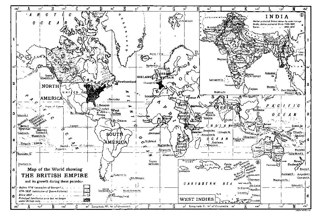
The empire contains or is bounded by some of the highest mountains, the greatest lakes, and the most important rivers of the world. Its climates may be said to include all the known climates of the world; its soils are no less various. In the prairies of central Canada it possesses some of the most valuable wheat-producing land; in the grass lands of the interior of Australia the best pasture country; and in the uplands of South Africa the most valuable gold- and diamond-bearing beds which exist. The United Kingdom at present produces more coal than any other single country except the United States. The effect of climate throughout the empire in modifying the type of the Anglo-Saxon race has as yet received only partial attention, and conclusions regarding it are of a somewhat empiric nature. The general tendency in Canada is held to be towards somewhat smaller size, and a hardy active habit; in Australia to a tall, slight, pale development locally known as "cornstalkers," characterized by considerable nervous and intellectual activity. In New Zealand the type preserves almost exactly the characteristics of the British Isles. The South African, both Dutch and British, is readily recognized by an apparently sun-dried, lank and hard habit of body. In the tropical possessions of the empire, where white settlement does not take place to any considerable extent, the individual alone is affected. The type undergoes no modification. It is to be observed in reference to this interesting aspect of imperial development, that the multiplication and cheapening of channels of communication and means of travel throughout the empire will tend to modify the future accentuation of race difference, while the variety of elements in the vast area occupied should have an important, though as yet not scientifically traced, effect upon the British imperial type.
The white population of the empire[1] reached in 1901 a total of over 53,000,000, or something over one-eighth of its entire Population. population, which, including native races, is estimated at about 400,000,000. The white population includes some French, Dutch and Spanish peoples, but is mainly of Anglo-Saxon race. It is distributed roughly as follows:—
United Kingdom and home dependencies 41,608,791
Australasia 4,662,000
British North America 5,500,000
Africa (Dutch and British)[2] 1,000,000
India 169,677
West Indies and Bermuda 100,000
—————
53,040,468
The native population of the empire includes types of the principal black, yellow and brown races, classing with these the high-type races of the East, which may almost be called white. The native population of India, mainly high type, brown, was returned at the census of 1901 as 294,191,379. The population of India is divided into 118 groups on the basis of language. These may, however, be collected into the following principal groups:—
(A) Malayo-Polynesian. (B) Indo-Chinese: i. Mon-Khmer. ii. Tibeto-Burman. iii. Siamese-Chinese. (C) Dravido-Muṇḍā: i. Muṇḍā (Kolarian). ii. Dravidian. (D) Indo-European. Indo-Aryan sub-family. (E) Semitic. (F) Hamitic. (G) Unclassed, e.g. Gipsy.
Eastern Colonies
Ceylon, high type, brown and mixed 3,568,824
Straits Settlements, brown, mixed and Chinese 570,000
Hong-Kong, Chinese and brown 306,130
North Borneo, mixed brown and Sarawak 700,000
—————
5,144,954
Of the various races which inhabit these Eastern dependencies the most important are the 2,000,000 Sinhalese and the 954,000 Tamil that make up the greater part of the population of Ceylon. The rest is made up of Arabs, Malays, Chinese (in the Straits Settlements and Hong-Kong), Dyaks, Eurasians and others.
West Indies.
The West Indies, including the continental colonies of British Guiana and Honduras, and seventeen islands or groups of islands, have a total coloured population of about 1,912,655. The colonies of this group which have the largest coloured populations are:—
Jamaica—Chiefly black, some brown and yellow 790,000
Trinidad and Tobago—Black and brown 250,000
British Guiana—Black and brown 286,000
—————
1,326,000
The populations of the West Indies are very various, being made up largely of imported African negroes. In Jamaica these contribute four-fifths of the population. There are also in the islands a considerable number of imported East Indian coolies and some Chinese. The aboriginal races include American Indians of the mainland and Caribs. With these there has been intermixture of Spanish and Portuguese blood, and many mixed types have appeared. The total European population of this group of colonies amounts to upwards of 80,000, to which 15,000 on account of Bermuda may be added.
Africa.
Chiefly black, estimated
South 5,211,329
Central 2,000,000
The aboriginal races of South Africa were the Bushmen and Hottentots. Both these races are rapidly diminishing in numbers, and in British South Africa it is expected that they will in the course of the twentieth century become extinct. Besides these primitive races there are the dark-skinned negroids of Bantu stock, commonly known in their tribal groups as Kaffirs, Zulu, Bechuana and Damara, which are again subdivided into many lesser groups. The Bantu compose the greater part of the native population. There are also in South Africa Malays and Indians and others, who during the last two hundred years have been introduced from Java, Ceylon, Madagascar, Mozambique and British India, and by intermarriage with each other and with the natives have produced a hybrid population generally classed together under the heading of the Mixed Races. These are of all colours, varying from yellow to dark brown. The tribes of Central Africa are as yet less known. Many of them exhibit racial characteristics allied to those of the tribes of South Africa, but with in some cases an admixture of Arab blood.
East Africa.
Protectorate—Black and brown:
—Natives (estimated) 4,000,000
—Asiatics (estimated) 25,000
Zanzibar—Black and brown 200,000
Uganda 3,200,000
—————
Total 7,425,000
West Africa.
Estimated.
Nigeria (including Lagos)—Black and brown 15,000,000
Gold Coast and hinterland—Chiefly black 2,700,000
Sierra Leone—Chiefly black 1,000,000
Gambia—Chiefly black 163,000
—————
18,863,000
From east to west across Africa the aboriginal nations are mostly of the black negroid type, their varieties being only imperfectly known. The tendency of some of the lower negroid types has been to drift towards the west coast, where they still practise cannibalistic and fetish rites. On the east coast are found much higher types approaching to the Christian races of Abyssinia, and from east to west there has been a wide admixture of Arab blood producing a light-brown type. In Uganda and Nigeria a large proportion of the population is Arab and relatively light-skinned.
Australasia.
Australia—Black, very low type 200,000
—Chinese and half castes, yellow 50,000
New Zealand—Maoris, brown, Chinese and half castes 53,000
Fiji—Polynesian, black and brown 121,000
Papua—Polynesian, black and brown 400,000
———— 824,000
The native races of Australia and the Polynesian groups of islands are divided into two main types known as the dark and light Polynesian. The dark type, which is black, is of a very low order, and in some of the islands still retains its cannibal habits. The aboriginal tribes of Australia are of a low-class black race, but generally peaceful and inoffensive in their habits. The white Polynesian races are of a very superior type, and exhibit, as in the Maoris of New Zealand, characteristics of a high order. The natives of Papua (New Guinea) are in a very low state of civilization. The estimate given of their numbers is approximate, as no census has been taken.
Canada.
Indians—Brown 100,000
The only coloured native races of Canada are the Red Indians, many in tribal variety, but few in number.
Summary.
Native Populations:
India 294,191,379
Ceylon and Eastern Colonies 5,144,954
West Indies 1,912,655
South Africa 5,211,329
British Central Africa 2,000,000
East Africa 7,425,000
West Africa 18,863,000
Australasia and Islands 824,000
Canada 100,000
—————— 335,672,317
White populations 53,040,468
Total 388,712,785
This is without taking into account the population of the lesser crown colonies or allowing for the increase likely to be shown by later censuses. Throughout the empire, and notably in the United Kingdom, there is among the white races a considerable sprinkling of Jewish blood.
The latest calculation of the entire population of the world, including a liberal estimate of 650,000,000 for peoples not brought under any census, gives a total of something over 1,500,000,000. The population of the empire may therefore be calculated as amounting to something more than one-fourth of the population of the world.
It is a matter of first importance in the geographical distribution of the empire that the five principal divisions, the United Divisions. Kingdom, South Africa, India, Australia and Canada are separated from each other by the three great oceans of the world. The distance as usually calculated in nautical miles: from an English port to the Cape of Good Hope is 5840 m.; from the Cape of Good Hope to Bombay is 4610; from Bombay to Melbourne is 5630; from Melbourne to Auckland is 1830; from Auckland to Vancouver is 6210; from Halifax to Liverpool is 2744. From a British port direct to Bombay by way of the Mediterranean it is 6272; from a British port by the same route to Sydney 11,548 m. These great distances have necessitated the acquisition of intermediate ports suitable for coaling stations on the trade routes, and have determined the position of many of the lesser crown colonies which are held simply for military and commercial purposes. Such are the Bermudas, Gibraltar, Malta, Aden, Ceylon, the Straits Settlements, Labuan, Hong-Kong, which complete the chain of connexion on the eastern route, and such on other routes are the lesser West African stations, Ascension, St. Helena, the Mauritius and Seychelles, the Falklands, Tristan da Cunha, and the groups of the western Pacific. Other annexations of the British empire have been rocky islets of the northern Pacific required for the purpose of telegraph stations in connexion with an all-British cable.
For purposes of political administration the empire falls into the three sections of the United Kingdom of Great Britain and Ireland, with the dependencies of the Channel Islands and the Isle of Man; the Indian empire, consisting of British India and the feudatory native states; and the colonial empire, comprising all other colonies and dependencies.
In the modern sense of extension beyond the limits of the United Kingdom the growth of the empire is of comparatively Growth. recent date. The Channel Islands became British as a part of the Norman inheritance of William the Conqueror. The Isle of Man, which was for a short time held in conquest by Edward I. and restored, was sold by its titular sovereign to Sir William Scrope, earl of Wiltshire, in 1393, and by his subsequent attainder for high treason and the confiscation of his estates, became a fief of the English crown. It was granted by Henry IV. in 1406 to Sir John Stanley, K.C., ancestor of the earls of Derby, by whom it was held till 1736, when it passed to James Murray, 2nd duke of Atholl, as heir-general of the 10th earl. It was inherited by his daughter Charlotte, wife of the 3rd duke of Atholl, who sold it to the crown for £70,000 and an annuity of £2000. With these exceptions and the nominal possession taken of Newfoundland by Sir Humphrey Gilbert in 1583, all the territorial acquisitions of the empire have been made in the 17th and subsequent centuries.
The following is a list of the British colonies and dependencies (other than those belonging to the Indian empire) together with a summary statement of the date and method of their acquisition. Arranged in chronological order they give some idea of the rate of growth of the empire. The dates are not, however, in all cases those in which British sovereignty was established. They indicate in some instances only the first definite step, such as the building of a fort, the opening of a trading station, or other act, which led later to the incorporation in the empire of the country indicated. In the case of Australian states or Canadian provinces originally part of other states or provinces the date is that, approximately, of the first settlement of British in the district named; e.g. there were British colonists in Saskatchewan in the last half of the 18th century, but the province was not constituted until 1905. Save where otherwise stated, British authority has been continuous from the first date mentioned in the table. Reference should be made to the articles on the various colonies.
Name. Date. Method of Acquisition.
Newfoundland 1583 Possession taken by Sir H. Gilbert for the crown.
17th Century.
Barbados 1605-1625 Settlement.
Bermudas 1609 "
Gambia c. 1618 " A second time in 1816.
St Christopher 1623 " Did not become wholly British until 1713.
Novia Scotia 1628 " Ceded to France 1632; recovered 1713.
Nevis 1628 "
Montserrat 1632 "
Antigua 1632 "
Honduras 1638 "
St Lucia 1638 " Finally passed to Great Britain in 1803.
Gold Coast c. 1650 Settlement. Danish forts bought 1850, Dutch forts 1871. Northern Territories added 1897.
St Helena 1651 Settled by East India Co. Government vested in British crown 1833.
Jamaica 1655 Conquest.
Bahamas 1666 Settlement.
Virgin Islands 1666-1672 Settlement and conquest.
N.W. Territories of Canada 1669 Settlement under royal charter of Hudson's Bay Co. Purchased from imp. gov. 1869, and transferred to Canada 1870.
Turks and Caicos Is. 1678 Settlement.
18th Century.
Gibraltar 1704 Capitulation.
New Brunswick 1713 Cession.
Prince Edward Is. 1758 Conquest.
Ontario 1759-1790 With New Brunswick and Nova
Quebec 1759-1790 Scotia constituted Dominion of Canada 1867. Prince Edward Is. enters the confederation 1873. In 1880 all British possessions (other than Newfoundland) in North America annexed to the Dominion.
Dominica 1761 Conquest.
St Vincent 1762 Capitulation.
Grenada 1762 "
Tobago 1763 Cession. Afterwards in French possession. Reconquered 1803.
Falkland Is. 1765 Settlement. Reoccupied 1832.
Saskatchewan 1766 Settlement. Separation from N.W. Territories of Canada 1905.
Pitcairn I. 1780 Settlement.
Straits Settlements 1786 to 1824 Settlement and cession. Vested (1858) in crown by E.I. Co. Transferred from Indian to colonial possessions 1867. Malacca in British occupation 1795-1818.
Sierra Leone 1787 Settlement.
Alberta c. 1788 Separated from N. W. Territories of Canada 1905.
New South Wales 1788 Settlement.
Ceylon 1795 Capitulation.
Trinidad 1797 "
Malta 1800 "
19th Century.
British Guiana 1803 Capitulation.
Tasmania 1803 Settlement.
Cape of Good Hope 1806 Capitulation. Present limits not attained until 1895. First British occupation 1795-1803.
Seychelles 1806 Capitulation.
Mauritius 1810 "
Manitoba 1811 Settlement by Red River or Selkirk colony. Created province of Canada 1870.
Ascension and Tristan da Cunha 1815 Military occupation.
B. Columbia and Vancouver Island 1821 Settlement under Hudson's Bay Co. Entered Canadian confederation 1871.
Natal 1824 Settlement. Natal Boers submit 1843.
Queensland 1824 Separated from New South Wales 1859.
West Australia 1826 Settlement.
Victoria 1834 Separated from New South Wales 1851.
South Australia 1836 Settlement.
New Zealand 1840 Settlement and treaty.
Hong-Kong 1841 Treaties. Kowloon on the mainland added in 1860; additional area leased 1898.
Labuan 1846 Cession. Incorporated in Straits Settlements 1906.
Lagos 1861 Cession. South Nigeria amalgamated with Lagos, under style of Colony and Protectorate of Southern Nigeria 1906.
Basutoland 1868 Annexation.
Fiji 1874 Cession.
W. Pacific Islands, including including Union, Ellice, Gilbert, Southern Solomon, and other groups 1877 High commission created by order in council, giving jurisdiction over islands not included in other colonial governments, nor within jurisdiction of other civilized powers. Protectorates declared over all these islands by 1900.
Federated Malay States 1874-1895 Treaty.
Cyprus 1878 Occupied by treaty.
North Borneo 1881 Treaty and settlement under royal charter. Protectorate assumed 1888.
Papua 1884 Protectorate declared.
Nigeria 1884-1886 Treaty, conquest and settlement under royal charter. Chartered Co.'s territory transferred to crown, and whole divided into North and South Nigeria 1900.
Somaliland 1884-1886 Occupation and cession. Protectorate declared 1887.
Bechuanaland 1885-1891 Protectorate declared. Southern portion annexed to Cape Colony 1895.
Zululand 1887 Annexation. Incorporated in Natal 1897.
Sarawak 1888 Protectorate declared.
Brunei 1888 " "
British East Africa 1888 Treaty, conquest and settlement under royal charter. Transferred to crown 1895.
Rhodesia 1888-1893 Treaty, conquest and settlement under royal charter.
Zanzibar 1890 Protectorate declared.
Uganda 1890-1896 Treaty and protectorate.
Nyasaland 1891 Protectorate declared.
Ashanti 1896 Military occupation.
Wei-hai-wei 1898 Lease from China.
Pacific Islands—
—Christmas, Fanning, Penrhyn, Suvarov 1898 Annexed for purposes of projected Pacific cable.
—Choiseul and Isabel Is. (Solomon Group) 1899 Cession.
—Tonga and Niué 1900 Protectorate declared.
Orange Free State 1900 Annexation. Formerly British 1848-1854.
Transvaal and Swaziland 1900 Annexation. Formerly British 1877-1881.
20th Century.
Kelantan, Trengganu, &c. 1909 Cession from Siam.
In the Pacific are also Bird Island, Bramble Cay, Cato Island, Cook Islands, Danger Islands, Ducie Island, Dudosa, Howland Island, Jarvis Island, Kermadec Islands, Macquarie Island, Manihiki Islands, Nassau Island, Palmerston Island, Palmyra Island, Phoenix Group, Purdy Group, Raine Island, Rakaanga Island, Rotumah Island, Surprise Island, Washington or New York Island, Willis Group and Wreck Reef.
In the Indian Ocean there are, besides the colonies already mentioned, Rodriguez, the Chagos Islands, St Brandon Islands, Amirante Islands, Aldabra, Kuria Muria Islands, Maldive Islands and some other small groups.
In certain dependencies the sovereignty of Great Britain is not absolute. The island of Cyprus is nominally still part of the Turkish empire, but in 1878 was handed over to Great Britain for occupation and administration; Great Britain now making to the Porte on account of the island an annual payment of £5000. The administration is in the hands of an official styled high commissioner, who is invested with the powers usually conferred on a colonial governor. In Zanzibar and other regions of equatorial Africa the native rulers retain considerable powers; in the Far East certain areas are held on lease from China.
Egypt, without forming part of the British empire, came under the military occupation of Great Britain in 1882. "By right of conquest" Great Britain subsequently claimed a share in the administration of the former Sudan provinces of Egypt, and an agreement of the 19th of January 1899 established the joint sovereignty of Great Britain and Egypt over what is now known as the Anglo-Egyptian Sudan.
The Indian section of the empire was acquired during the 17th-19th centuries under a royal charter granted to the East India Company by Queen Elizabeth in 1600. It was transferred to the imperial government in 1858, and Queen Victoria was proclaimed empress under the Royal Titles Act in 1877. The following list gives the dates and method of acquisition of the centres of the main divisions of the Indian empire. They have, in most instances, grown by general process of extension to their present dimensions.
Name. Date. Method of Acquisition.
Madras 1639 to 1748 By treaty and subsequent conquest. Fort St George, the foundation of Madras was the first territorial possession of the E.I. Co. in India. It was acquired by treaty with its Indian ruler. Madras was raised into a presidency in 1683; ceded to France 1746; recovered 1748.
Bombay 1608 to 1685 Treaty and cession. Trade first established 1608. Ceded to British crown by Portugal 1661. Transferred to E.I. Co. 1668. Presidency removed from Surat 1687.
Bengal 1633 to 1765 Treaty and subsequent conquests. First trade settlement established by treaty at Pipli in Orissa 1633. Erected into presidency by separation from Madras 1681. Virtual sovereignty announced by E.I. Co., as result of conquests of Clive, 1765.
United Provinces of Agra and Oudh 1764 to 1856 By conquests and treaty through successive stages, of which the principal dates were 1801-3-14-15. In 1832 the nominal sovereignty of Delhi, till then retained by the Great Mogul, was resigned into the hands of the E.I. Co. Oudh, of which the conquest may be said to have begun with the battle of Baxar in 1764, was finally annexed in 1856.
Central Provinces 1802-1817 By conquest and treaty.
Eastern Bengal and Assam 1825-1826 Conquest and cession. The Bengal portion of the province by separation from Bengal in 1905.
Burma 1824-1852 Conquest and cession.
Punjab 1849 Conquest and annexation. Made into distinct province 1859.
N.-W. Frontier Province 1901 Subdivision.
Ajmere and Merwara 1818 By conquest and cession.
Coorg 1834 Conquest and annexation.
British Baluchistan 1854-1876 Conquest and treaty.
Andaman Islands 1858 Annexation.
The following is a list of some of the principal Indian states which are more or less under the control of the British government:—
1. In direct political relations with the governor-general in council.
Hyderabad. Baroda. Mysote. Kashmir.
2. Under the Rajputana agency.
Udaipur. Jodhpur. Bikanir. Jaipur (and feudatories). Bharatpur. Dholpur. Alwar. Tonk.
3. Under the Central Indian agency.
Indore. Rewa. Bhopal. Gwalior.
4. Under the Bombay government.
Cutch. Kolhapur (and dependencies). Khairpur (Sind). Bhaunagar.
5. Under the Madras government.
Travancore. Cochin.
6. Under the Central Provinces government.
Bastar.
7. Under the Bengal government.
Kuch Behar. Sikkim.
8. Under United Provinces government.
Rampur. Garhwal.
9. Under the Punjab government.
Patiala. Bahawalpur. Jind. Nabha. Kapurthala. Mandi. Sirmur (Nahan). Faridkot. Chamba.
10. Under the government of Burma.
Shan states. Karen states.
In addition to these there are British tracts known as the Upper Burma frontier and the Burma frontier. There is also a sphere of British influence in the border of Afghanistan. The state of Nepal, though independent as regards its internal administration, has been since the campaign of 1814-15 in close relations with Great Britain. It is bound to receive a British resident, and its political relations with other states are controlled by the government of India. All these native states have come into relative dependency upon Great Britain as a result of conquest or of treaty consequent upon the annexation of the neighbouring provinces. The settlement of Aden, with its dependencies of Perim and Sokotra Island, forms part of the government of Bombay.
This vast congeries of states, widely different in character, and acquired by many different methods, holds together under Administration. the supreme headship of the crown on a generally acknowledged triple principle of self-government, self-support and self-defence. The principle is more fully applied in some parts of the empire than in others; there are some parts which have not yet completed their political evolution; some others in which the principle is temporarily or for special reasons in abeyance; others, again—chiefly those of very small extent, which are held for purposes of the defence or advantage of the whole—to which it is not applicable; but the principle is generally acknowledged as the structural basis upon which the constitution of the empire exists.
In its relation to the empire the home section of the British Isles is distinguished from the others as the place of origin of the British race and the residence of the crown. The history and constitutional development of this portion of the empire will be found fully treated under separate headings. (See England; Wales; Ireland; Scotland; United Kingdom; English History; India; Africa; Australia; Canada; &c.)
It is enough to say that for purposes of administration the Indian empire is divided into nine great provinces and four minor commissionerships. The nine great provinces are presided over by two governors (Bombay and Madras), five lieut.-governors (Bengal, Eastern Bengal and Assam, United Provinces [Agra and Oudh], the Punjab and Burma), a chief commissioner (the Central Provinces) and an agent to the governor-general (the N.-W. Frontier Province). The four minor commissionerships are presided over each by a chief commissioner. Above these the supreme executive authority in India is vested in the viceroy in council. The council consists of six ordinary members besides the existing commander-in-chief. For legislative purposes the governor-general's council is increased by the addition of fifteen members nominated by the crown, and has power under certain restrictions to make laws for British India, for British subjects in the native states, and for native Indian subjects of the crown in any part of the world. The administration of the Indian empire in England is carried on by a secretary of state for India assisted by a council of not less than ten members. The expenditure of the revenues is under the control of the secretary in council.
The colonial empire comprises over fifty distinct governments. It is divided into colonies of three classes and dependencies; these, again, are in some instances associated for administrative purposes in federated groups. The three classes of colonies are crown colonies, colonies possessing representative institutions but not responsible government, and colonies possessing representative institutions and responsible government. In crown colonies the crown has entire control of legislation, and the public officers are under the control of the home government. In representative colonies the crown has only a veto on legislation, but the home government retains control of the public officers. In responsible colonies the crown retains a veto upon legislation, but the home government has no control of any public officer except the governor.
In crown colonies—with the exception of Gibraltar and St Helena, where laws may be made by the governor alone—laws are made by the governor with the concurrence of a council nominated by the crown. In some crown colonies, chiefly those acquired by conquest or cession, the authority of this council rests wholly on the crown; in others, chiefly those acquired by settlement, the council is created by the crown under the authority of local or imperial laws. The crown council of Ceylon may be cited as an example of the first kind, and the crown council of Jamaica of the second.
In colonies possessing representative institutions without responsible government, the crown cannot (generally) legislate by order in council, and laws are made by the governor with the concurrence of the legislative body or bodies, one at least of these bodies in cases where a second chamber exists possessing a preponderance of elected representatives. The Bahamas, Barbados, and Bermuda have two legislative bodies—one elected and one nominated by the crown; Malta and the Leeward Islands have but one, which is partly elected and partly nominated.
Under responsible government legislation is carried on by parliamentary means exactly as at home, with a cabinet responsible to parliament, the crown reserving only a right of veto, which is exercised at the discretion of the governor in the case of certain bills. The executive councils in those colonies, designated as at home by parliamentary choice, are appointed by the governor alone, and the other public officers only nominally by the governor on the advice of his executive council.
Colonial governors are classed as governors-general; governors; lieut.-governors; administrators; high commissioners; and commissioners, according to the status of the colony and dependency, or group of colonies and dependencies, over which they preside. Their powers vary according to the position which they occupy. In all cases they represent the crown.
As a consequence of this organization the finance of crown colonies is under the direct control of the imperial government; the finance of representative colonies, though not directly controlled, is usually influenced in important departures by the opinion of the imperial government. In responsible colonies the finance is entirely under local control, and the imperial government is dissociated from either moral or material responsibility for colonial debts.
In federated groups of colonies and dependencies matters which are of common interest to a given number of separate governments are by mutual consent of the federating communities adjudged to the authority of a common government, which, in the case of self-governing colonies, is voluntarily created for the purpose. The associated states form under the federal government one federal body, but the parts retain control of local matters, and exercise all their original rights of government in regard to these. The two great self-governing groups of federated colonies within the empire are the Dominion of Canada and the Commonwealth of Australia. In South Africa unification was preferred to federation, the then self-governing colonies being united in 1910 into one state—the Union of South Africa. India, of which the associated provinces are under the control of the central government, may be given as an example of the practical federation of dependencies. Examples of federated crown colonies and lesser dependencies are to be found in the Leeward Island group of the West Indies and the federated Malay States.
This rough system of self-government for the empire has been evolved not without some strain and friction, by the recognition through the vicissitudes of three hundred years of the value of independent initiative in the development of young countries. Queen Elizabeth's first patent to Sir Walter Raleigh permitted British subjects to accompany him to America, "with guarantee of a continuance of the enjoyment of all the rights which her subjects enjoyed at home."
This guarantee may presumably have been intended at the time only to assure the intending settlers that they should lose no rights of British citizenship at home by taking up their residence in America. Its mutual interpretation in a wider sense, serving at once to establish in the colony rights of citizenship equivalent to those enjoyed in England, and to preserve for the colonist the status of British subject at home and abroad, has formed in application to all succeeding systems of British colonization the unconscious charter of union of the empire.
The first American colonies were settled under royal grants, each with its own constitution. The immense distance in time which in those days separated America from Great Britain secured them from interference by the home authorities. They paid their own most moderate governing expenses, and they contributed largely to their own defence. From the middle of the 17th century their trade was not free, but this was the only restriction from which they suffered. The great war with France in the middle of the 18th century temporarily destroyed this system. That war, which resulted in the conquest of Canada and the delivery of the North American colonies from French antagonism, cost the imperial exchequer £90,000,000. The attempt to avert the repetition of such expenditure by the assertion of a right to tax the colonies through the British parliament led to the one great rupture which has marked the history of the empire. It has to be noted that at home during the latter half of the 17th century and the earlier part of the 18th century parliamentary power had to a great extent taken the place of the divine right of kings. But parliamentary power meant the power of the English people and taxpayers. The struggle which developed itself between the American colonies and the British parliament was in fact a struggle on the part of the people and taxpayers of one portion of the empire to resist the domination of the people and taxpayers of another portion. In this light it may be accepted as having historically established the fundamental axiom of the constitution of the empire, that the crown is the supreme head from which the parts take equal dependence.
The crown requiring advice in the ordinary and constitutional manner receives it in matters of colonial administration from the secretaries of state for the colonies and for India. After the great rupture separate provision in the home government for the administration of colonial affairs was at first judged to be unnecessary, and the "Council[3] of Trade and Plantations," which up to that date had supplied the place now taken by the two offices of the colonies and India, was suppressed in 1782. There was a reaction from the liberal system of colonial self-government, and an attempt was made to govern the colonies simply as dependencies.
In 1791, not long after the extension of the range of parliamentary authority in another portion of the empire, by the creation in 1784 of the Board of Control for India, Pitt made the step forward of granting to Canada representative institutions, of which the home government kept the responsible control. Similar institutions were also given at a later period to Australia and South Africa. But the long peace of the early part of the 19th century was marked by great colonial developments; Australia, Canada and South Africa became important communities. Representative institutions controlled by the home government were insufficient, and they reasserted the claim for liberty to manage their own affairs.
Fully responsible government was granted to Canada in 1840, and gradually extended to the other colonies. In 1854 a separate secretary of state for the colonies was appointed at home, and the colonial office was established on its present footing. In India, as in the colonies, there came with the growing needs of empire a recognition of the true relations of the parts to each other and of the whole to the crown. In 1858, on the complete transference of the territories of the East India Company to the crown, the board of control was abolished, and the India Council, under the presidency of a secretary of state for India, was created. It was especially provided that the members of the council may not sit in parliament.
Thus, although it has not been found practicable in the working of the British constitution to carry out the full theory of the direct and exclusive dependence of colonial possessions on the crown, the theory is recognized as far as possible. It is understood that the principal sections of the empire enjoy equal rights under the crown, and that none is subordinate to another. The intervention of the imperial parliament in colonial affairs is only admitted theoretically in so far as the support of parliament is required by the constitutional advisers of the crown. To bring the practice of the empire into complete harmony with the theory it would be necessary to constitute, for the purpose of advising the crown on imperial affairs, a council in which all important parts of the empire should be represented.
The gradual recognition of the constitutional theory of the British empire, and the assumption by the principal Imperialism. colonies of full self-governing responsibilities, has cleared the way for a movement in favour of a further development which should bring the supreme headship of the empire more into accord with modern ideas.
It was during the period of domination of the "Manchester school," of which the most effective influence in public affairs was exerted for about thirty years, extending from 1845 to 1875, that the fullest development of colonial self-government was attained, the view being generally accepted at that time that self-governing institutions were to be regarded as the preliminary to inevitable separation. A general inclination to withdraw from the acceptance of imperial responsibilities throughout the world gave to foreign nations at the same time an opportunity by which they were not slow to profit, and contributed to the force of a reaction of which the part played by Great Britain in the scramble for Africa marked the culmination. Under the increasing pressure of foreign enterprise, the value of a federation of the empire for purposes of common interest began to be discussed. Imperial federation was openly spoken of in New Zealand as early as 1852. A similar suggestion was officially put forward by the general association of the Australian colonies in London in 1857. The Royal Colonial Institution, of which the motto "United Empire" illustrates its aims, was founded in 1868. First among leading British statesmen to repudiate the old interpretation of colonial self-government as a preliminary to separation, Lord Beaconsfield, in 1872, spoke of the constitutions accorded to the colonies as "part of a great policy of imperial consolidation." In 1875 W. E. Forster, afterwards a member of the Liberal government, made a speech in which he advocated imperial federation as a means by which it might become practicable to "replace dependence by association." The foundation of the Imperial Federation League—in 1884, with Forster for its first president, shortly to be succeeded by Lord Rosebery—marked a distinct step forward. The Colonial Conferences of 1887 and subsequent years (the title being changed to Imperial Conference in 1907), in which colonial opinion was sought and accepted in respect of important questions of imperial organization and defence, and the enthusiastic loyalty displayed by the colonies towards the crown on the occasion of the jubilee manifestations of Queen Victoria's reign, were further indications of progress in the same direction. Coincidently with this development, the achievements of Sir George Goldie and Cecil Rhodes, who, the one in West Africa and the other in South Africa, added between them to the empire in a space of less than twenty years a dominion of greater extent than the whole of British India, followed by the action of a host of distinguished disciples in other parts of the world, effectually stemmed the movement initiated by Cobden and Bright. A tendency which had seemed temporarily to point towards a complacent dissolution of the empire was arrested, and the closing years of the 19th century were marked by a growing disposition to appreciate the value and importance of the unique position which the British empire has created for itself in the world. No stronger demonstration of the reality of imperial union could be needed than that which was afforded by the support given to the imperial forces by the colonies and India in the South African War. It remained only to be seen by what process of evolution the further consolidation of the empire would find expression in the machinery of government. A step in this direction was taken in 1907, when at the Colonial Conference held in London that year it was decided to form a permanent secretariat to deal with the common interests of the self-governing colonies and the mother-country. It was further decided that conferences, to be called in future Imperial Conferences, between the home government and the governments of the self-governing dominions, should be held every four years, and that the prime minister of Great Britain should be ex officio president of the conference. No executive power was, however, conferred upon the conference.
The movement in favour of tariff reform initiated by Mr Chamberlain (q.v.) in 1903 with the double object of giving a preference to colonial goods and of protecting imperial trade by the imposition in certain cases of retaliative duties on foreign goods, was a natural evolution of the imperialist idea, and of the fact that by this time the trade-statistics of the United Kingdom had proved that trade with the colonies was forming an increasingly large proportion of the whole. In spite of the defeat of the Unionist party in England in 1906, and the accession to power of a Liberal government opposed to anything which appeared to be inconsistent with free trade, the movement for colonial preference, based on tariff reform, continued to make headway in the United Kingdom, and was definitely adopted by the Unionist party. And at the Imperial Conference of 1907 it was advocated by all the colonial premiers, who could point to the progress made in their own states towards giving a tariff preference to British goods and to those of one another.
The question of self-government is closely associated with the question of self-support. Plenty of good land and the liberty to manage their own affairs were the causes assigned by Adam Smith for the marked prosperity of the British colonies towards the end of the 18th century. The same causes are still observed to produce the same effects, and it may be pointed out that, since the date of the latest of Adam Smith's writings, upwards of 6,000,000 sq. m. of virgin soil, rich with possibilities of agricultural, pastoral and mineral wealth, have been added to the empire. In the same period the white population has grown from about 12,000,000 to 53,000,000, and the developments of agricultural and industrial machinery have multiplied, almost beyond computation, the powers of productive labour.
It is scarcely possible within this article to deal with so widely varied a subject as that of the productions and industry of the The imperial factor in industry and trade. empire. For the purposes of a general statement, it is interesting to observe that concurrently with the acquisition of the vast continental areas during the 19th century, the progress of industrial science in application to means of transport and communication brought about a revolution of the most radical character in the accepted laws of economic development. Railways did away with the old law that the spread of civilization is necessarily governed by facilities for water carriage and is consequently confined to river valleys and sea-shores. Steam and electricity opened to industry the interior of continents previously regarded as unapproachable. The resources of these vast inland spaces which have lain untouched since history began became available to individual enterprise, and over a great portion of the earth's surface were brought within the possessions of the British empire. The production of raw material within the empire increased at a rate which can only be appreciated by a careful study of figures, and by a comparison of the total of these figures with the total figures of the world. The tropical and temperate possessions of the empire include every field of production which can be required for the use of man. There is no main staple of human food which is not grown; there is no material of textile industry which is not produced. The British empire gives occupation to more than one-third of the persons employed in mining and quarrying in the world. It may be interesting, as an indication of the relative position in this respect of the British empire to the world, to state that at present it produces one-third of the coal supply of the world, one-sixth of the wheat supply, and very nearly two-thirds of the gold supply. But while these figures may be taken as in themselves satisfactory, it is far more important to remember that as yet the potential resources of the new lands opened to enterprise have been barely conceived, and their wealth has been little more than scratched. Population as yet has been only very sparsely sprinkled over the surface of many of the areas most suitable for white settlement. In the wheat lands of Canada, the pastoral country of Australasia, and the mineral fields of South Africa and western Canada alone, the undeveloped resources are such as to ensure employment to the labour and satisfaction to the needs of at least as many millions as they now contain thousands of the British race. In respect of this promise of the future the position of the British empire is unique.