Front matter
Reading edition
[Transcriber's Notes: These modifications are intended to provide continuity of the text for ease of searching and reading. 1. To avoid breaks in the narrative, page numbers (shown in curly brackets "{1234}") are usually placed between paragraphs. In this case the page number is preceded and followed by an empty line. To remove page numbers use the Regular Expression: "^{[0-9]+}" to "" (empty string) 2. If a paragraph is exceptionally long, the page number is placed at the nearest sentence break on its own line, but without surrounding empty lines. 3. Blocks of unrelated text are moved to a nearby break between subjects. 5. Use of em dashes and other means of space saving are replaced with spaces and newlines. 6. Subjects are arranged thusly: --------------------------------- MAIN SUBJECT TITLE IN UPPER CASE Subheading one. Subheading two. Subject text. See CROSS REFERENCE ONE. See Also CROSS REFERENCE TWO. John Smith, External Citation Title, Chapter 3, page 89. --------------------------------- Main titles are at the left margin, in all upper case (as in the original) and are preceded by an empty line. Subheadings (if any) are indented three spaces and immediately follow the main title. Text of the article (if any) follows the list of subtitles (if any) and is preceded with an empty line and indented three spaces. References to other articles in this work are in all upper case (as in the original) and indented six spaces. They usually begin with "See", "Also" or "Also in". Citations of works outside this book are indented six spaces and in italics (as in the original). The bibliography in Volume 1, APPENDIX F on page xxi provides additional details, including URLs of available internet versions. ----------Subject: Start-------- ----------Subject: End---------- indicates the start/end of a group of subheadings or other large block. To search for words separated by an unknown number of other characters, use this Regular Expression to find the words "first" and "second" separated by between 1 and 100 characters: "first.{1,100}second" A list of all words used in this work is found at the end of this file as an aid for finding words with unusual spellings that are archaic, contain non-Latin letters, or are spelled differently by various authors. Search for: "Word List: Start". I use these free search tools: Notepad++ -- https://notepad-plus-plus.org Agent Ransack or FileLocator Pro -- https://www.mythicsoft.com Several tables are best viewed using a fixed spacing font such Courier New. End Transcriber's Notes.] ----------------------------------
Spine
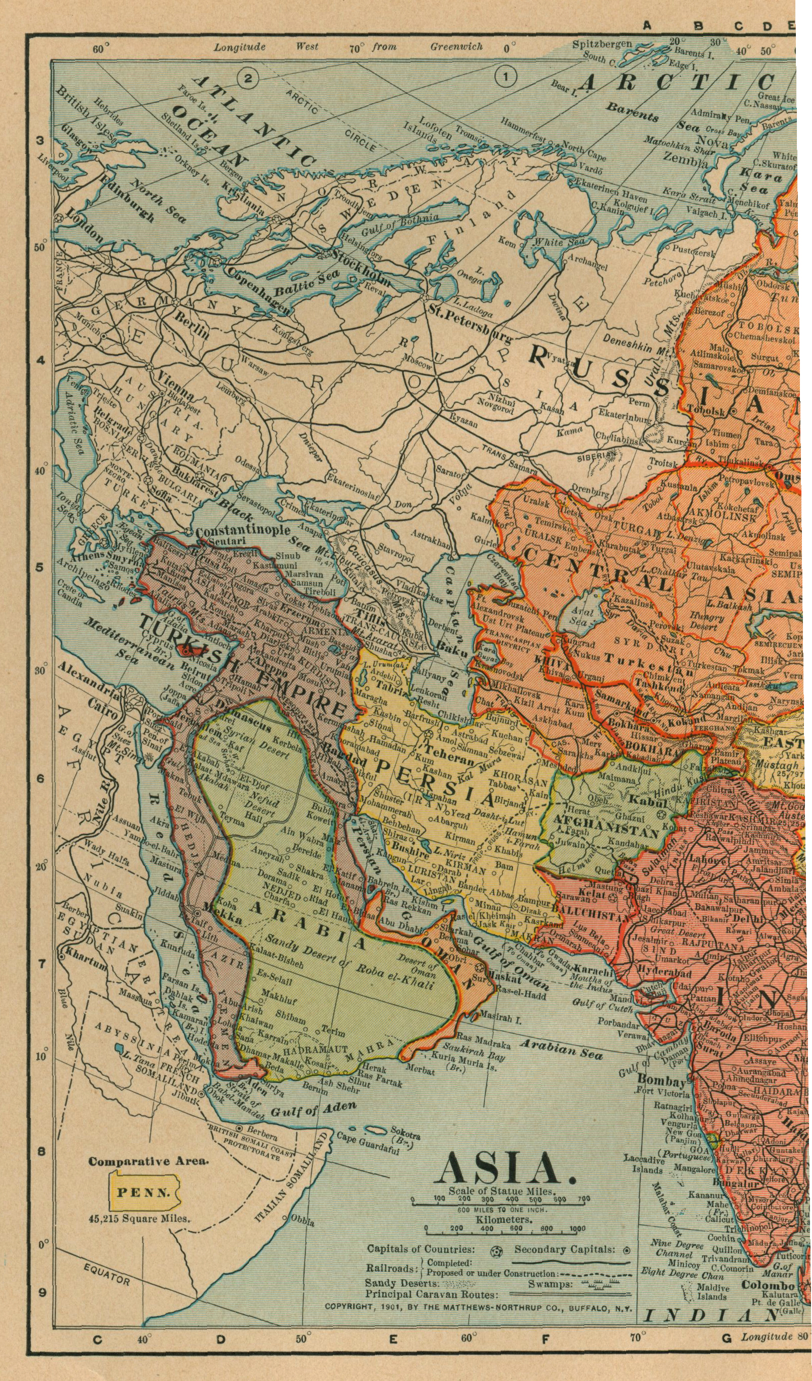
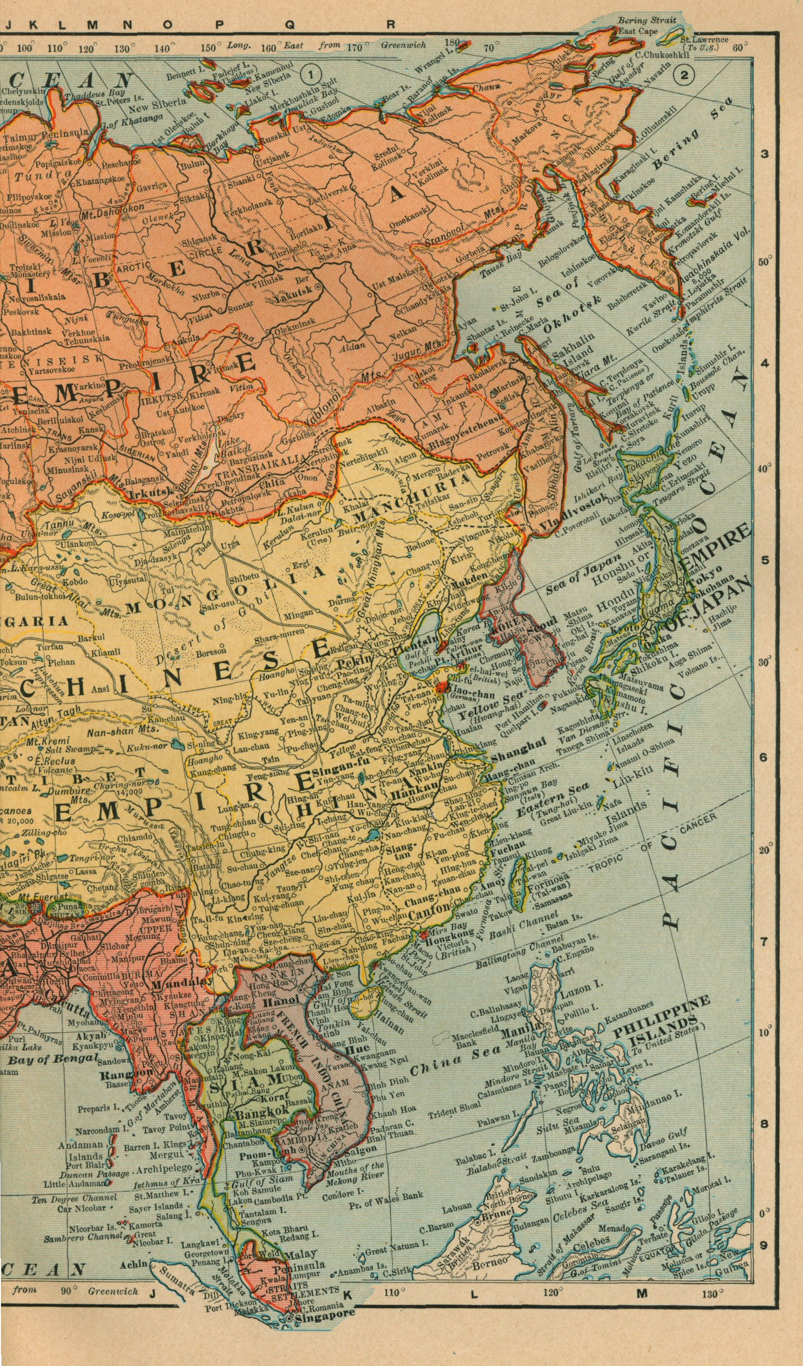
Map of Asia
HISTORY FOR READY REFERENCE. FROM THE BEST HISTORIANS, BIOGRAPHERS, AND SPECIALISTS THEIR OWN WORDS IN A COMPLETE SYSTEM OF HISTORY FOR ALL USES, EXTENDING TO ALL COUNTRIES AND SUBJECTS, AND REPRESENTING FOR BOTH READERS AND STUDENTS THE BETTER AND NEWER LITERATURE OF HISTORY IN THE ENGLISH LANGUAGE BY J. N. LARNED WITH NUMEROUS HISTORICAL MAPS FROM ORIGINAL STUDIES AND DRAWINGS BY ALAN O. REILEY REVISED AND ENLARGED EDITION IN SIX VOLUMES VOLUME VI—RECENT HISTORY 1894-5 TO 1901 A to Z SPRINGFIELD, MASS. THE C. A. NICHOLS CO., PUBLISHERS COPYRIGHT, 1901, BY J. N. LARNED. The Riverside Press, Cambridge, Massachusetts, U. S. A. Printed by H. O. Houghton & Company. PREFACE TO THE SIXTH VOLUME. The six years that have passed since the original five volumes of this compilation were published, in 1894-5, have been filled with events so remarkable and changes so revolutionary in political and social conditions that the work has seemed to need an extension to cover them. The wish for such an extension, expressed by many people, led to the preparation of a new volume, in which all the lines of the historical record are taken from the points at which they were dropped in the early volumes, and are carried to the end of the Nineteenth Century, and beyond it, into the opening months of the present year. In plan and arrangement this additional volume is uniform with the preceding ones; but the material used in it is different from that dealt with before, and a quite different character is given consequently to the book. The former compilation represented closet-studies of History—perspective views of a past more or less remote from those who depicted it. This one, on the contrary, exhibits History in the making,—the day by day evolution of events and changes as they passed under the hands and before the eyes and were recorded by the pens of the actual makers and witnesses of them. If there is crudeness in the story thus constructed, there is life in it, to quite make good the lack of literary finish; and the volume is expected to prove as interesting and as useful as its predecessors. It sets forth, with the fulness which their present-day interest demands, all the circumstances that led to the Spanish-American war; the unforeseen sequences of that war, in the Philippine Islands, in Cuba, in Porto Rico, and in American politics; the whole controversy of Great Britain with the South African Boers and the resulting war; the shameful dealings of western nations with China, during late years, which provoked the outbreak of barbaric hostility to foreigners, and the dreadful experiences of the siege and relief of Peking; the strange Dreyfus agitations in France; the threatening race-conflicts in Austria; the change of sovereign in England; the Peace Conference at The Hague and its results; the federation of the Australian colonies; the development of industrial combinations or trusts in the United States; the archæological discoveries of late years in the East, and the more notable triumphs of achievement in the scientific world. On these and other occurrences of the period surveyed, the record of fact is quoted from sources the most responsible and authentic now available, and always with the endeavor to present both sides of controverted matters with strict impartiality. For purposes of reference and study, a large number of important documents—laws, treaties, new constitutions of government, and other state papers—are given in full, and, in most instances, from officially printed texts. BUFFALO, NEW YORK; May, 1901. ACKNOWLEDGMENTS. I am indebted to the following named authors, editors, and publishers, for permission kindly given me to quote from books and periodicals, all of which are duly referred to in connection with the passages severally borrowed from them: The manager of The American Catholic Quarterly Review; the editor of The American Journal of Archæology; the editor of The American Monthly Review of Reviews; General Thomas F. Anderson; Messrs. D. Appleton & Company; Messrs. Wm. Blackwood's Sons (Blackwood's Magazine); Mr. Andrew Carnegie; Messrs. Chapman & Hall (The Fortnightly Review); Mr. Samuel L. Clemens (Mark Twain); Hon. W. Bourke Cockran; the editor of The Contemporary Review; Prof. John Franklin Crowell; the G. W. Dillingham Company; Messrs. Dodd, Mead & Company; Messrs. Doubleday, Page & Company; The Ecumenical Conference on Foreign Missions; Mr. J. Foreman; The Forum Publishing Company; Harper & Brothers (Harper's Magazine); Mr. Howard C. Hillegas; Prof. H. V. Hilprecht; Hon. Frederick W. Holls; Messrs. Houghton, Mifflin & Company (The Atlantic Monthly); Mr. George Iles; the editor of The Independent; Prof. John H. Latané; Messrs. Longmans, Green & Company (The Edinburgh Review); Mr. Charles F. Lummis; Messrs. McClure, Philips & Company (The Popular Science Monthly); Messrs. MacMillan & Company (London); The New Amsterdam Book Company; the editor of The Nineteenth Century Review; the editor of The North American Review; the editors of The Outlook; the managing editor of The Political Science Quarterly; Mr. Edward Porritt; Messrs. G. P. Putnam's Sons; Messrs. Charles Scribner's Sons; George M. Sternberg, Surgeon-General, U. S. A.; The Frederick A. Stokes Company; the managing editor of The Sunday School Times; Prof. F. W. Taussig; Prof. Elihu Thomson; the manager of The Times, London; The University Press, Cambridge; Mr. Herbert Welsh; the editors of The Yale Review. My acknowledgments are likewise due to the Hon. D. S. Alexander, Representative in Congress, and to many officials at Washington, for courteous assistance in procuring publications of the national government for my use. LIST OF MAPS. Map of Asia, Preceding the title page Map of Africa, Following page 2 Map of Alaska, Following page 8 Map of Australia, Following page 30 Map of Central America, showing the Isthmian Canal routes, Following page 66 Map of the East Coast of China, Following page 76 Map of Cuba and the West Indies, Following page 170 Map of Hawaii, Following page 254 Map of the Philippine Islands, and of the seat of war in Luzon, Following page 368 Map of Porto Rico, Following page 410 Map of the Boer Republics and their surroundings, Following page 492 Map illustrating the Santiago campaign in the Spanish-American war, On page 603 LIST OF TABLES. The descendants of Queen Victoria, Page 215 Protestant foreign missions and missionary societies, Pages 311-313 Navies of the Sea Powers, Page 318 Philippine Islands, area and population, Pages 367-369 The Shipping of the World in 1900, Page 452 British military forces in South African war, Pages 509-510 Statistics of the Spanish-American War, Pages 628-631 Twelfth Census of the United States (1900), Pages 645-646 Revenues and expenditures of the government of the United States for the fiscal year ended June 30, 1900, Page 666 Losses from all causes in the armies of the United States from May 1, 1898, to May 20, 1900, Pages 666-667 Qualifications of the elective franchise in the several States of the United States, Pages 676-677 Military and naval expenditures of the greater Powers, Pages 694-697 Chronological record of events, 1895 to 1901, Pages 702-720 {1} HISTORY FOR READY REFERENCE. ABORIGINES, American. See (in this volume) INDIANS, AMERICAN. ABRUZZI, the Duke of: Arctic expedition. See (in this volume) POLAR EXPLORATION, 1899-1900, 1901. ABYDOS, Archæological exploration at. See (in this volume) ARCHÆOLOGICAL RESEARCH: EGYPT: RESULTS. ABYSSINIA: A. D. 1895-1896. Successful war with the Italians. See (in this volume) ITALY: A. D. 1895-1896. ABYSSINIA: A. D. 1897. Treaty with Great Britain. A treaty between King Menelek of Abyssinia and the British Government was concluded in May, 1897. It gives to British subjects the privileges of the most favored nations in trade; opens the port of Zeyla to Abyssinian importations; defines the boundary of the British Somali Protectorate, and pledges Abyssinia to be hostile to the Mahdists. ACETYLENE GAS, Production of. See (in this volume) SCIENCE, RECENT: CHEMISTRY AND PHYSICS. ADOWA, Battle of. See (in this volume) ITALY; A. D. 1895-1896. AFGHANISTAN: A. D. 1893-1895. Relinquishment of claims over Swat, Bajaur and Chitral. See (in this volume) INDIA: A. D. 1895 (MARCH-SEPTEMBER). AFGHANISTAN: A. D. 1894. The Waziri War. See (in this volume) INDIA: A. D. 1894. AFGHANISTAN: A. D. 1895. Anglo-Russian Agreement. Determination of the northern frontier. The joint Anglo-Russian Commission for fixing the northern frontier of Afghanistan, from Zulfikar on the Heri-Rud to the Pamirs, finished its work in July, 1895. This was consequent upon an Agreement between the governments of Great Britain and Russia which had been reduced to writing on the previous 11th of March. In part, that Agreement was as follows: "Her Britannic Majesty's Government and the Government of His Majesty the Emperor of Russia engage to abstain from exercising any political influence or control, the former to the north, the latter to the south, of the above line of demarcation. Her Britannic Majesty's Government engage that the territory lying within the British sphere of influence between the Hindu Kush and the line running from the east end of Lake Victoria to the Chinese frontier shall form part of the territory of the Ameer of Afghanistan, that it shall not be annexed to Great Britain, and that no military posts or forts shall be established in it. The execution of this Agreement is contingent upon the evacuation by the Ameer of Afghanistan of all the territories now occupied by His Highness on the right bank of the Panjah, and on the evacuation by the Ameer of Bokhara of the portion of Darwaz which lies to the south of the Oxus, in regard to which Her Britannic Majesty's Government and the Government of His Majesty the Emperor of Russia have agreed to use their influence respectively with the two Ameers." Great Britain, Papers by Command: Treaty Series, Number 8, 1895. AFGHANISTAN: A. D. 1896. Conquest of Kafiristan. By the agreement of 1893, between the Ameer of Afghanistan and the government of India (see, in this volume, INDIA. A. D. 1895-MARCH-SEPTEMBER), the mountain district of Kafiristan was conceded to the former, and he presently set to work to subjugate its warlike people, who had never acknowledged his yoke. By the end of 1896 the conquest of these Asiatic Kafirs was believed to be complete. AFGHANISTAN: A. D. 1897-1898. Wars of the British with frontier tribes. See (in this volume) INDIA: A. D. 1897-1898. AFGHANISTAN: A. D. 1900. Russian railway projects. See (in this volume) RUSSIA-IN-ASIA: A. D. 1900. ----------AFRICA: Start-------- AFRICA: A. D. 1891-1900 (Portuguese East Africa). Delagoa Bay Railway Arbitration. See (in this volume) DELAGOA BAY ARBITRATION. AFRICA: A. D. 1893 (Niger Coast Protectorate). Its growth. See (in this volume) NIGERIA: A. D. 1882-1899. AFRICA: A. D. 1894 (The Transvaal). The Commandeering question. See (in this volume) SOUTH AFRICA: (THE TRANSVAAL): A. D. 1894. AFRICA: A. D. 1894 (The Transvaal). Dissatisfaction of the Boers with the London Convention of 1884. See (in this volume) SOUTH AFRICA (THE TRANSVAAL): A. D. 1884-1894. AFRICA: A. D. 1894-1895 (British South Africa Company). Extension of charter and enlargement of powers. Influence of Cecil J. Rhodes. Attitude towards the Transvaal. See (in this volume) SOUTH AFRICA (BRITISH SOUTH AFRICA COMPANY): A. D. 1894-1895. AFRICA: A. D. 1894-1895 (Rhodesia). Extended territory and enlarged powers of the British South Africa Company. Ascendancy of Cecil J. Rhodes. See (in this volume) SOUTH AFRICA (BRITISH SOUTH AFRICA COMPANY): A. D. 1894-1895. AFRICA: A. D. 1894-1898 (British Central Africa Protectorate: Nyassaland). Administrative separation from British South Africa Company's territory. Conflicts with natives. Resources and prospects. See (in this volume) BRITISH CENTRAL AFRICA PROTECTORATE. {2} AFRICA: A. D. 1895 (Bechuanaland). Partial conveyance to British South Africa Company. Several Bechuana chiefs visited England to urge that their country should not be absorbed by Cape Colony or the British South Africa Company. An agreement was made with them which reserved certain territories to each, but yielded the remainder to the administration of the British South Africa Company. AFRICA: A. D. 1895 (British East Africa). Transfer of territory to the British Government. The territories previously administered by the Imperial British East Africa Company (excepting the Uganda Protectorate, which had been transferred in 1894) were finally transferred to the British Government on the 1st of July. At the same time, the dominion of the Sultan of Zanzibar on the mainland came under the administrative control of the British consul-general at Zanzibar. AFRICA: A. D. 1895 (Cape Colony). Annexation of British Bechuanaland. Proceedings for the annexation of British Bechuanaland to Cape Colony were adopted by the Cape Parliament in August. AFRICA: A. D. 1895 (French West Africa). Appointment of a Governor-General. In June, M. Chaudie was appointed Governor-General of French West Africa, his jurisdiction extending over Senegal, the Sudan possessions of France, French Guinea, Dahomey, and other French possessions in the Gulf of Benin. AFRICA: A. D. 1895 (Orange Free State). Proposed federal union of the Free State with the Transvaal. A resolution making overtures for a federal union with the Transvaal was passed by the Volksraad of the Orange Free State in June. AFRICA: A. D. 1895 (Sierra Leone). Establishment of a British Protectorate over the Hinterland of Sierra Leone. Anglo-French boundary agreement. See (in this volume) SIERRA LEONE PROTECTORATE. AFRICA: A. D. 1895 (Transvaal). Action in Swaziland. By a proclamation in February, the Transvaal Government assumed the administration of Swaziland and installed King Buna as paramount chief. AFRICA: A. D. 1895 (The Transvaal). Closing of the Vaal River Drifts. See (in this volume) SOUTH AFRICA (THE TRANSVAAL): A. D. 1895 (SEPTEMBER-DECEMBER). AFRICA: A. D. 1895 (The Transvaal). Discontent of the Uitlanders. The Franchise question. See (in this volume) SOUTH AFRICA (THE TRANSVAAL): A. D. 1895 (NOVEMBER). AFRICA: A. D. 1895 (The Transvaal). Opening of Delagoa Bay Railway. See (in this volume) SOUTH AFRICA (THE TRANSVAAL): A. D. 1895 (JULY). AFRICA: A. D. 1895 (Zululand). Extension of Boundary. A strip of territory west of Amatongaland, along the Pondoland River to the Maputa was formally added to Zululand in May, the South African Republic protesting. AFRICA: A. D. 1895-1896 (Portuguese East Africa). War with Gungunhana. The Portuguese were involved in war with Gungunhana, king of Gazaland, which lasted from September, 1895, until the following spring, when Gungunhana was captured and carried a prisoner, with his wives and son, to Lisbon. AFRICA: A. D. 1895-1896 (The Transvaal). Revolutionary conspiracy of Uitlanders at Johannesburg. The Jameson raid. See (in this volume) SOUTH AFRICA (THE TRANSVAAL): A. D. 1895-1896. AFRICA: A. D. 1895-1897 (British East Africa Protectorate). Creation of the Protectorate. Territories included. Subjugation of Arab chiefs. Report of commissioner. See (in this volume) BRITISH EAST AFRICA PROTECTORATE: A. D. 1895-1897. AFRICA: A. D. 1896 (Ashanti). British conquest and occupation. See (in this volume) ASHANTI. AFRICA: A. D. 1896 (British South Africa Company). Resignation of Mr. Rhodes. Parliamentary movement to investigate. See (in this volume) SOUTH AFRICA (BRITISH SOUTH AFRICA COMPANY): A. D. 1896 (JUNE); and (JULY). AFRICA: A. D. 1896 (Cape Colony). Investigation of the Jameson raid. See (in this volume) SOUTH AFRICA (CAPE COLONY): A. D. 1896 (JULY). AFRICA: A. D. 1896 (Rhodesia). Matabele revolt. See (in this volume) SOUTH AFRICA (RHODESIA): A. D. 1896 (MARCH-SEPTEMBER). AFRICA: A. D. 1896 (Zanzibar). Suppression of an usurper by the British. On the sudden death (supposed to be from poison) of the Sultan of Zanzibar, August 25, his cousin, Said Khalid, seized the palace and proclaimed himself sultan. Zanzibar being an acknowledged protectorate of Great Britain, the usurper was summoned by the British consul to surrender. He refused, and the palace was bombarded by war vessels in the harbor, with such effect that the palace was speedily destroyed and about 500 of its inmates killed. Khalid fled to the German consul, who protected him and had him conveyed to German territory. A new sultan, Said Hamud-bin-Mahomed was at once proclaimed. AFRICA: A. D. 1896-1899 (The Transvaal). Controversies with the British Government. See (in this volume) SOUTH AFRICA (THE TRANSVAAL): A. D. 1896 (JANUARY-APRIL), to 1899 (SEPTEMBER-OCTOBER). AFRICA: A. D. 1897 (Congo Free State). Mutiny of troops. The Congo troops of an expedition led by Baron Dhanis mutinied and murdered a number of Belgian officers. Subsequently they were attacked in the neighborhood of Lake Albert Edward Nyanza and mostly destroyed. AFRICA: A. D. 1897 (Dahomey and Tongoland). Definition of boundary. By a convention concluded in July between Germany and France, the boundary between German possessions in Tongoland and those of France in Dahomey and the Sudan was defined. AFRICA: A. D. 1897 (Nigeria). Massacre at Benin. British expedition. Capture of the town. See (in this volume) NIGERIA: A. D. 1897. AFRICA: A. D. 1897 (Nigeria). Subjugation of Fulah slave-raiders. In January and February, the forces of the Royal Niger Company successfully invaded the strong Fulah states of Nupé and Ilorin, from which slave raiding in the territory under British protection was carried on. Bida, the Nupé capital, was entered on the 27th of January, after a battle in which 800 Hausa troops, led by European officers, and using heavy artillery, drove from the field an army of cavalry and foot estimated at 30,000 in number. The Emir of Nupé was deposed, another set up in his place, and a treaty signed which established British rule. The Emir of Ilorin submitted after his town had been bombarded, and bowed himself to British authority in his government. At the same time, a treaty settled the Lagos frontier. Later in the year, the stronghold at Kiffi of another slave-raider, Arku, was stormed and burned.
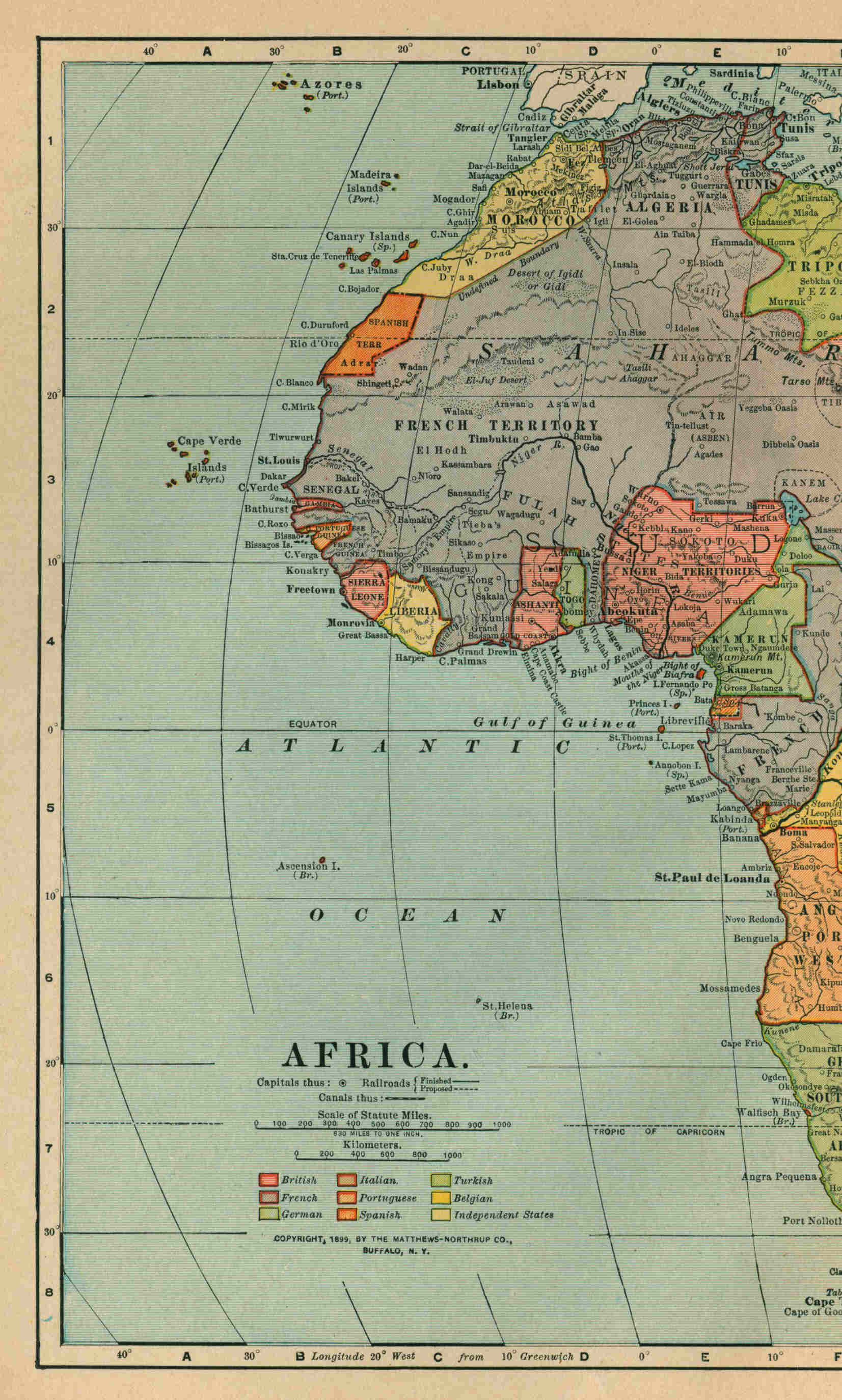
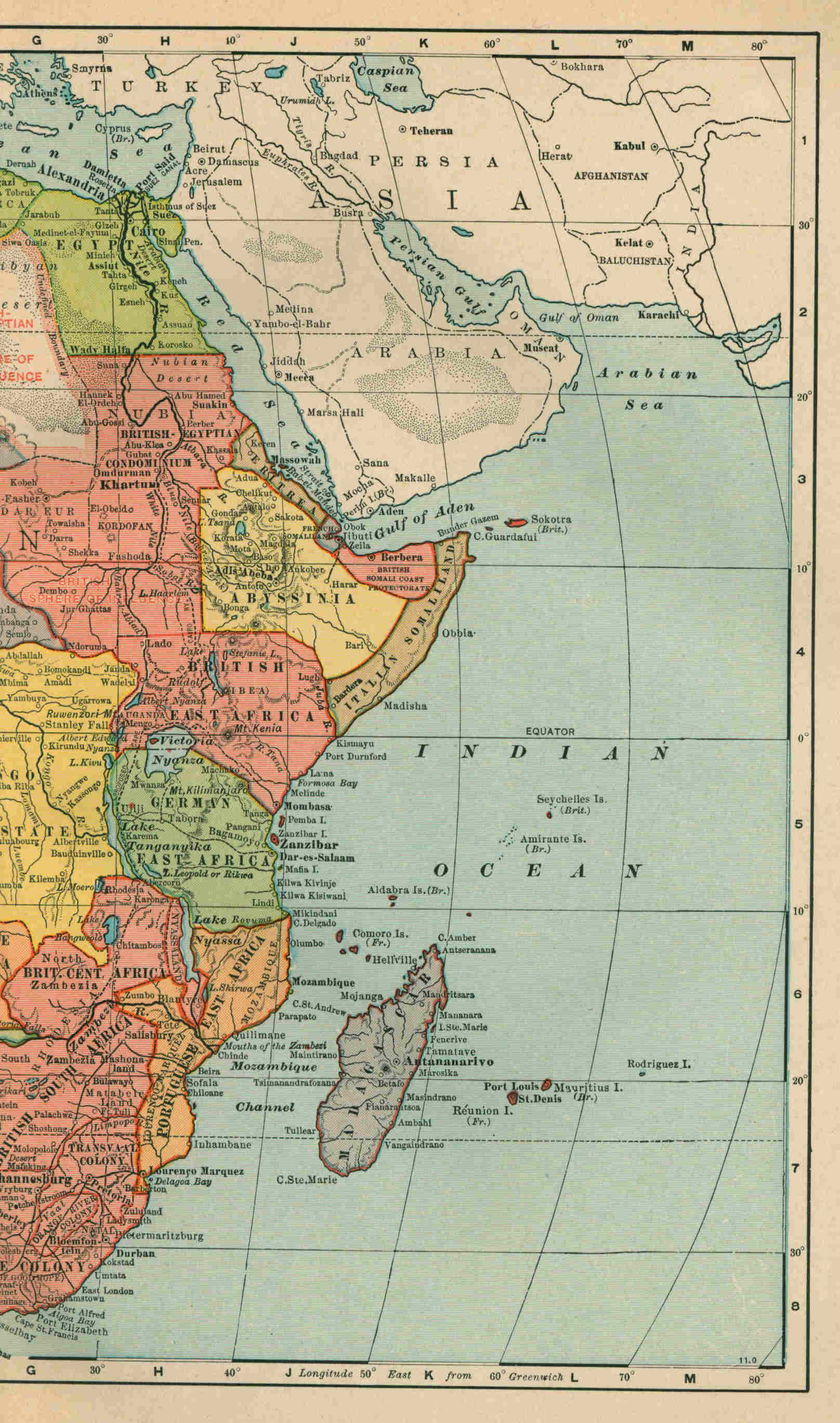
Map of Africa
{3} AFRICA: A. D. 1897 (Orange Free State and Transvaal). Treaty defensive between the two republics. See (in this volume) SOUTH AFRICA (ORANGE FREE STATE AND TRANSVAAL): A. D. 1897 (APRIL). AFRICA: A. D. 1897 (Sudan). Beginning of the Anglo-Egyptian conquest. See (in this volume) EGYPT: A. D. 1885-1896. A. D. 1897 (Zanzibar). Abolition of slavery. Under pressure from the British government, the Sultan of Zanzibar issued a decree, on the 6th or April, 1897, terminating the legal status of slavery, with compensation to be awarded on proof of consequent loss. AFRICA: A. D. 1897 (Zululand). Annexation to Natal. By act of the Natal Parliament in December, 1897, Zululand (with Amatongaland already joined to it) was annexed to Natal Colony, and Dinizulu, son of the last Zulu king, was brought from captivity in St. Helena and reinstated. AFRICA: A. D. 1897-1898 (Sudan). Completion of the Anglo-Egyptian conquest. See (in this volume) EGYPT: A. D. 1897-1898. AFRICA: A. D. 1897-1898 (Uganda). Native insurrections and mutiny of Sudanese troops in Uganda. See (in this volume) UGANDA: A. D. 1897-1898. AFRICA: A. D. 1898 (Abyssinia). Treaty of King Menelek with Great Britain. See (in this volume) ABYSSINIA: A. D. 1898. AFRICA: A. D. 1898 (British South Africa Company). Reorganization. See (in this volume) SOUTH AFRICA (RHODESIA): A. D. 1898 (FEBRUARY). AFRICA: A. D. 1898 (Egypt). The Nile question between England and France. Marchand's expedition at Fashoda. See (in this volume) EGYPT: A. D. 1898 (SEPTEMBER-NOVEMBER). AFRICA: A. D. 1898 (Nigeria and the French Sudan). Definition of French and English possessions in West and North Africa. See (in this volume) NIGERIA: A. D. 1882-1899. AFRICA: A. D. 1898 (Rhodesia). Reorganization of the British South Africa Company and the administration of its territories. See (in this volume) SOUTH AFRICA (RHODESIA AND THE BRITISH SOUTH AFRICA COMPANY): A. D. 1898 (FEBRUARY). AFRICA: A. D. 1898 (Tunis). Results of the French Protectorate. See (in this volume) TUNIS: A. D. 1881-1898. AFRICA: A. D. 1899. Railway development. "Railroad development in Africa has been rapid in the past few years and seems but the beginning of a great system which must contribute to the rapid development, civilization, and enlightenment of the Dark Continent. Already railroads run northwardly from Cape Colony about 1,400 miles, and southwardly from Cairo about 1,100 miles, thus making 2,500 miles of the 'Cape to Cairo' railroad complete, while the intermediate distance is about 3,000 miles. Mr. Rhodes, whose recent visit to England and Germany in the interest of the proposed through line from the Cape to Cairo is a matter of record, and whose visit to Germany was made necessary by the fact that in order to pass from the southern chain of British territory to the northern chain he must cross German or Belgian territory, is reported as confident that the through line will be completed by the year 1910. Certainly it may reasonably be assumed that a continuous railway line will be in operation from the southern to the northern end of Africa in the early years of the twentieth century. Toward this line, present and prospective, which is to stretch through the eastern part of the continent, lateral lines from either coast are beginning to make their way. A line has already been constructed from Natal on the southeast coast: another from Lourenço Marquez in Portuguese territory and the gold and diamond fields: another from Beira, also in Portuguese territory, but considerably farther north, and destined to extend to Salisbury in Rhodesia, where it will form a junction with the 'Cape to Cairo' road; still another is projected from Zanzibar to Lake Victoria Nyanza, to connect, probably, at Tabora, with the transcontinental line; another line is under actual construction westward from Pangani just north of Zanzibar, both of these being in German East Africa; another line is being constructed northwestwardly from Mombasa, in British territory, toward Lake Victoria Nyanza, and is completed more than half the distance, while at the entrance to the Red Sea a road is projected westwardly into Abyssinia, and is expected to pass farther toward the west and connect with the main line. At Suakim, fronting on the Red Sea, a road is projected to Berber, the present terminus of the line running southwardly from Cairo. On the west of Africa lines have begun to penetrate inward, a short line in the French Sudan running from the head of navigation on the Senegal eastwardly toward the head of navigation on the Niger, with the ultimate purpose of connecting navigation on these two streams. In the Kongo Free State a railway connects the Upper Kongo with the Lower Kongo around Livingstone Falls; in Portuguese Angola a road extends eastwardly from Loanda, the capital, a considerable distance, and others are projected from Benguela and Mossamedes with the ultimate purpose of connecting with the 'Cape to Cairo' road and joining with the lines from Portuguese East Africa, which also touch that road, thus making a transcontinental line from east to west, with Portuguese territory at either terminus. Farther south on the western coast the Germans have projected a road from Walfisch Bay to Windhoek, the capital of German Southwest Africa, and this will probably be extended eastwardly until it connects with the great transcontinental line from 'Cape to Cairo,' which is to form the great nerve center of the system, to be contributed to and supported by these branches connecting it with either coast. Another magnificent railway project, which was some years ago suggested by M. Leroy Beaulieu, has been recently revived, being no less than an east and west transcontinental line through the Sudan region, connecting the Senegal and Niger countries on the west with the Nile Valley and Red Sea on the east and penetrating a densely populated and extremely productive region of which less is now known, perhaps, than of any other part of Africa. At the north numerous lines skirt the Mediterranean coast, especially in the French territory of Algeria and in Tunis, where the length of railway is, in round numbers, 2,250 miles, while the Egyptian railroads are, including those now under construction, about 1,500 miles in length. {4} Those of Cape Colony and Natal are nearly 3,000 miles, and those of Portuguese East Africa and the South African Republic another thousand. Taking into consideration all of the roads now constructed, or under actual construction, their total length reaches nearly 10,000 miles, while there seems every reason to believe that the great through system connecting the rapidly developing mining regions of South Africa with the north of the continent and with Europe will soon be pushed to completion. A large proportion of the railways thus far constructed are owned by the several colonies or States which they traverse, about 2,000 miles of the Cape Colony system belonging to the Government, while nearly all that of Egypt is owned and operated by the State." United States Bureau of Statistics, Monthly Summary, August, 1899. See, also, (in this volume), RAILWAY, CAPE TO CAIRO. AFRICA: A. D. 1899 (June). International Convention respecting the liquor traffic. Representatives of the governments of Great Britain, Germany, Belgium, Spain, the Congo State, France, Italy, the Netherlands, Portugal, Russia, Sweden and Norway, and Turkey, assembled at Brussels, in June, 1899, with due authorization, and there concluded an international convention respecting the liquor traffic in Africa. Subsequently the governments of Austria-Hungary, the United States of America, Liberia and Persia, gave their adhesion to the Convention, and ratifications were deposited at Brussels in June, 1900. The Convention is, in a measure, supplemental to what is known as "the General Act of Brussels," relative to the African slave trade, which was framed at a conference of the representatives of European, American, African, and Asiatic states, at Brussels. The treaty known as the General Act of Brussels was signed July 2, 1890, but did not come into force until April 2, 1894. The text of it may be found in (United States) House Doc. Number 276, 56th Congress, 3d Session. The Convention of 1899 provides: "Article I. From the coming into force of the present Convention, the import duty on spirituous liquors, as that duty is regulated by the General Act of Brussels, shall be raised throughout the zone where there does not exist the system of total prohibition provided by Article XCI, of the said General Act, to the rate of 70 fr. the hectolitre at 50 degrees centigrade, for a period of six years. It may, exceptionally, be at the rate of 60 fr. only the hectolitre at 50 degrees centigrade in the Colony of Togo and in that of Dahomey. The import duty shall be augmented proportionally for each degree above 50 degrees centigrade; It may be diminished proportionally for each degree below 50 degrees centigrade. At the end of the above-mentioned period of six years, the import duty shall be submitted to revision, taking as a basis the results produced by the preceding rate. The Powers retain the right of maintaining and increasing the duty beyond the minimum fixed by the present Article in the regions where they now possess that right. Article II. In accordance with Article XCIII of the General Act of Brussels, distilled drinks made in the regions mentioned in Article XCII of the said General Act, and intended for consumption, shall pay an excise duty. This excise duty, the collection of which the Powers undertake to insure as far as possible, shall not be lower than the minimum import duty fixed by Article I. of the present Convention. Article III. It is understood that the Powers who signed the General Act of Brussels, or who have acceded to it, and who are not represented at the present Conference, preserve the right of acceding to the present Convention." Great Britain, Parliamentary Publication. (Papers by Command: Treaty Series, Number 13, 1900). AFRICA: A. D. 1899. Progress of the Telegraph line from the Cape to Cairo. See (in this volume) TELEGRAPH, CAPE TO CAIRO. AFRICA: A. D. 1899 (German Colonies). Cost to Germany, trade, etc. See (in this volume) GERMANY: A. D. 1899 (JUNE). AFRICA: A. D. 1899 (Nigeria). Transfer of territory to the British Crown. See (in this volume) NIGERIA: A. D. 1899. AFRICA: A. D. 1899 (Orange Free State). Treaty of alliance with the Transvaal. Making common cause. See (in this volume) SOUTH AFRICA (ORANGE FREE STATE): A. D. 1897 (APRIL); and 1899 (SEPTEMBER-OCTOBER). AFRICA: A. D. 1899 (The Sudan). Anglo-Egyptian Condominium established. See (in this volume) EGYPT: A. D. 1899 (JANUARY). AFRICA: A. D. 1899 (Transvaal and Orange Free State). Outbreak of war with Great Britain. See (in this volume) SOUTH AFRICA (TRANSVAAL AND ORANGE FREE STATE): A. D. 1899 (SEPTEMBER-OCTOBER). AFRICA: A. D. 1899 (West Africa). Definition of British and German frontiers. See (in this volume) SAMOAN ISLANDS. AFRICA: A. D. 1899 (Zanzibar). Renunciation of rights of extra-territoriality by Germany. See (in this volume) SAMOAN ISLANDS. AFRICA: A. D. 1899-1900. Summary of the partition of the Continent. "Seven European nations, as before remarked, now control territories in Africa, two of them having areas equal in each case to about the entire land area of the United States, while a few small territories remain as independent States. Beginning at the northeast, Egypt and Tripoli are nominally at least tributaries of Turkey, though the Egyptian Government, which was given large latitude by that of Turkey, has of late years formed such relations with Great Britain that, in financial matters at least, her guidance is recognized; next west, Algeria, French; then Morocco on the extreme northwest, an independent Government and an absolute despotism; next on the south, Spain's territory of Rio de Oro; then the Senegal territories, belonging to the French, and connecting through the desert of Sahara with her Algeria; then a group of small divisions controlled by England, along the Gulf of Guinea; then Liberia, the black Republic; Togoland, controlled by the Germans; Dahomey, a French protectorate; the Niger territory, one-third the size of the United States, controlled by England; Kamerun, controlled by Germany; French Kongo; then the Kongo Free State, under the auspices of the King of Belgium, and occupying the very heart of equatorial Africa; then Portuguese Angola; next, German South west Africa; and finally in the march down the Atlantic side, Cape Colony, British. {5} Following up the eastern side comes the British colony of Natal; then just inland from this the two Boer Republics, the Orange Free State and the South African Republic, both of which are entirely in the interior, without ocean frontage; next, Portuguese Africa, and west of this the great territory known as 'Rhodesia'; then German Africa, which extends almost to the equator; north of these, British East Africa, fronting on the Indian Ocean, and merging northwardly with the Egyptian Sudan, which was recently recovered from the Mahdi by the joint operation of British and Egyptian troops, and the British flag placed side by side with that of Egypt; next north, upon the coast, Italian territory and a small tract opposite the entrance to the Red Sea controlled by England; and a few hundred miles west of the entrance to the Red Sea, the independent Kingdom of Abyssinia. This division of African territory, nearly all of it made within the memory of the present generation, forms the present political map of Africa. With England and France controlling an area equal in each case to that of the United States; Germany, a territory one-third the size of the United States; Portugal, with an area somewhat less; the Kongo Free State in the great equatorial basin, but having a frontage upon the Atlantic with an area nearly one-third that of the United States; Italy and Spain, each with a comparatively small area of territory; Egypt, with relations quite as much British as Turkish; Tripoli, Turkish, and the five independent States of Morocco, Liberia, Abyssinia, and the two Boer Republics—nothing remains unclaimed, even in the desert wastes, while in the high altitudes and subtropical climate of southeast Africa civilization and progress are making rapid advancement." United States Bureau of Statistics, Monthly Summary, August, 1899. The following table, given in an article in "The Forum," December, 1899, by Mr. O. P. Austin, Chief of the United States Bureau of Statistics, shows the area, total population, foreign population, and imports and exports of the territory in Africa held by each European Government and by the independent States of that continent, at the time of its compilation so far as could be ascertained; but the statistics of area and population, especially the latter, are in many cases necessarily estimates: POP. TOTAL FOREIGN PER SQ. AREA. POPULATION. POPULATION MILE IMPORTS. EXPORTS. French Africa. 3,028,000 28,155,000 922,000 9.3 $70,116,000 $69,354,000 British Africa. 2,761,000 35,160,000 455,000 12.8 131,398,000 131,835,000 Turkish Africa. 1,760,000 21,300,000 113,000 12.2 54,091,000 62,548,000 German Africa. 944,000 11,270,000 4,000 12.0 4,993,000 2,349,000 Belgian Africa. 900,000 30,000,000 2,000 33.3 4,522,000 3,309,000 Portuguese Africa. 790,000 8,059,000 3,000 10.2 11,863,000 6,730,000 Spanish Africa. 243,000 36,000 … 0.5 … … Italian Africa. 188,000 850,000 … 4.5 … … Independent States. Morocco. 219,000 5,000,000 … 22.8 6,402,000 6,261,000 Abyssinia. 150,000 3,500,000 … 23.3 … … South African Republic. 120,000 1,096,000 346,000 9.2 104,703,000 53,532,000 Orange Free State. 48,500 208,000 78,000 4.3 5,994,000 8,712,000 Liberia. 48,000 1,500,000 25,000 31.3 1,217,000 1,034,000 Total. 11,189,500 146,133,000 1,948,000 … $395,299,000 $345,714,000 According to a statistical table in the twentieth volume of Meyer's Konversations-Lexicon (third annual supplement), based upon the latest data furnished by the boundary treaties between the Powers, it would appear that all but about one-seventh of the African continent is now (A. D. 1900) included in some "protectorate" or "sphere of influence." The French sphere is the largest, comprising about 3,700,000 square miles (about the extent of Europe) out of a total area of 11,600,000. England comes next with 2,400,000 (including the Boer territories). Then follow in order Germany, Belgium (Congo Free State), and Portugal, each with somewhat less than a million square miles. The Egyptian sphere (about 400,000 square miles) may properly be regarded as part of the British. The extent of the French sphere will appear less imposing on consulting the map of Africa here given, which shows that it takes in the greater part of the sands of the Sahara. The British sphere (including Egypt and her dependencies) is estimated to contain in round numbers about 50,000,000 souls; the French, 35,000,000; the Belgian, 17,000,000; the German, 9,000,000; the Portuguese, 8,000,000. AFRICA: A. D. 1900 (Ashanti). Revolt of the tribes. Siege and relief of Kumasai. See (in this volume) ASHANTI. AFRICA: A. D. 1900 (Togoland and Gold Coast). Demarcation of the Hinterland. Late in November it was announced from Berlin that conferences regarding the British and German boundaries in West Africa were then in progress in the Colonial Department of the German Foreign Office, their principal object being the demarcation of the Hinterland of Togoland and of the Gold Coast, and in particular the partition of the neutral zone of Salaga as arranged in Article 5 of the Samoa Agreement between Great Britain and Germany. See (in this volume) SAMOAN ISLANDS. AFRIDIS, British Indian war with the. See (in this volume) INDIA: A. D. 1897-1898. AFRIKANDER BUND, The. See (in this volume) SOUTH AFRICA (CAPE, COLONY): A. D. 1881-1888; 1898; and 1898 (MARCH-OCTOBER). AFRIKANDER CONGRESS. See (in this volume) SOUTH AFRICA (Cape Colony): A. D. 1900 (DECEMBER). AFRIKANDERS: Joining the invading Boers. See (in this volume) SOUTH AFRICA (THE FIELD OF WAR): A. D. 1899 (OCTOBER-NOVEMBER.). AFRIKANDERS: Opposition to the annexation of the Boer Republics. See (in this volume) SOUTH AFRICA (CAPE COLONY): A. D. 1900 (MAY). {6} AGRARIAN PROTECTIONISTS, The German. See (in this volume) GERMANY: A. D. 1895-1898; 1899 (AUGUST); and 1901 (FEBRUARY). AGRICULTURAL LAND BILL, The. See (in this volume) ENGLAND: A. D. 1896. AGUINALDO y FAMY, Emilio. First appearance in the Filipino insurrection. His treaty with the Spaniards and departure from the Islands. See (in this volume) PHILIPPINE ISLANDS: A. D. 1896-1898. AGUINALDO y FAMY, Emilio. Circumstances in which he went to Manila to co-operate with American forces. See (in this volume) UNITED STATES OF AMERICA: A. D. 1898 (APRIL-MAY: PHILIPPINES). AGUINALDO y FAMY, Emilio. Arrival at Manila, May 19, 1898. His organization of insurgent forces. His relations with Admiral Dewey. See (in this volume) UNITED STATES OF AMERICA: A. D. 1898 (APRIL-JULY). AGUINALDO y FAMY, Emilio. Correspondence with General Anderson. See (in this volume) UNITED STATES OF AMERICA: A. D. 1898 (JULY-AUGUST: PHILIPPINES). AGUINALDO y FAMY, Emilio. Relations with American commander at Manila. Declared President of the Philippine Republic. See (in this volume) UNITED STATES OF AMERICA: A. D. 1898 (JULY-SEPTEMBER). AGUINALDO y FAMY, Emilio. Conflict of his army with American forces. See (in this volume) PHILIPPINE ISLANDS: A. D. 1898 (AUGUST-DECEMBER), and after. ALABAMA: A. D. 1899. Dispensary Laws. Acts applying the South Carolina "dispensary" system of regulation for the liquor traffic to seventeen counties, but not to the State at large, were passed by the Legislature. See, in this volume, SOUTH CAROLINA: A. D. 1892-1899. ALASKA: A. D. 1898-1899. Discovery of the Cape Nome gold mining region. "The Cape Nome mining region lies on the western coast of Alaska, just beyond the military reservation of St. Michael and about 120 miles south of the Arctic Circle. It can be reached by an ocean voyage of ten or twelve days from Seattle. It has long been known that gold exists in the general vicinity of Cape Nome, and during the last five or six years a few adventurous miners have done more or less prospecting and claim staking throughout the district lying between Norton and Kotzebue sounds. During the winter of 1898-99, a large number of miners entered the Kotzebue country, while others spent the season in the vicinity of Golofnin Bay." On the 15th of October, 1898, a party of seven men reached Snake River in a schooner. "Between that date and the 18th a miners' meeting was held, the boundaries of a district 25 miles square were established, local mining regulations were formulated, and Dr. Kittleson was elected recorder for a term of two years. After organizing the district natives were hired to do the necessary packing, and a camp was established on Anvil Creek. The prospecting outfits were quickly brought into service. In one afternoon $76 was panned out on Snow Creek. Encouraged by this showing lumber was carried up from the schooner and two rockers were constructed. … In four or five days over $1,800 was cleaned up with these two rockers. … The weather turned cold and the water was frozen up. As it was impossible to do any more work with the rockers the party broke camp on the 3d of November and returned to the schooner, which they found frozen solid in 2 feet of ice. They then made their way in a small boat to an Indian village, near Cape Nome, where they obtained dogs and sleds, and a little farther on they were met by reindeer from the Swedish Mission, with which they returned to Golofnin Bay. "The lucky miners had agreed among themselves that their discovery should be held secret, but the news was too good to keep, and soon leaked out. A general stampede commenced at once and continued all winter. Every available dog and reindeer was pressed into the service, and they were soon racing with each other for the valuable claims which had been left unstaked in the vicinity of Anvil Creek. As soon as that creek had been all taken up the stampede extended to the neighboring streams and gulches, and Glacier and Dexter creeks, as well as many others which have not proved equally valuable, were quickly staked and recorded. By the 25th of December a large party armed with numerous powers of attorney had entered the district, and as the local regulations allowed every man to stake on each creek one claim of the full legal dimensions (660 by 1,320 feet), it was not long until the whole district had been thoroughly covered, and nearly every stream had been staked with claims, which in some cases were 'jumped' and the right of possession disputed. "The news of a rich strike at Nome worked its way up the Yukon River during the winter, and as soon as the ice broke in June a large crowd came down from Rampart City, followed by a larger crowd from Dawson. The 'Yukoners,' as these people were called, were already disgusted with the hardships, disappointments, and Canadian misgovernment which they had met with on the upper river. … Those to whom enough faith had been given to go over to Cape Nome were disgusted and angered to find that pretty much the whole district was already staked, and that the claims taken were two or three times as large as those commonly allowed on the upper river. Another grievance was the great abuse of the power of attorney, by means of which an immense number of claims had been taken up, so that in many cases (according to common report) single individuals held or controlled from 50 to 100 claims apiece. … "A miners' meeting was called by the newcomers to remedy their grievances. Resolutions were prepared, in which it was represented that the district had been illegally organized by men who were not citizens of the United States and who had not conformed with the law in properly defining the boundaries of the district with reference to natural objects, in enacting suitable and sufficient mining regulations, and in complying with any of the details of organization required by law. It was intended by the promoters of this meeting to reorganize the district in such a way as would enable them to share the benefits of the discovery of a new gold field with the men who had entered it the previous winter, and, as they expressed it, 'gobbled up the whole country.' It is, of course, impossible to say what would have been the result if their attempt had not been interfered with. … On the 28th of June Lieutenant Spaulding and a detachment of 10 men from the Third Artillery had been ordered to the vicinity of Snake River, and on the 7th of July their numbers were increased by the addition of 15 more. {7} As soon as it was proposed to throw open for restaking a large amount of land already staked and recorded an appeal was made to the United States troops to prevent this action by prohibiting the intended meeting, which was called to assemble July 10. It was represented to them that if the newcomers should attempt, under the quasi-legal guise of a miners' meeting, to take forcible possession of lands already claimed by others, the inevitable consequence would be a reign of disorder and violence, with the possibility of considerable bloodshed. On the strength of this representation and appeal the army officers decided to prevent the adoption of the proposed resolutions. The miners were allowed to call their meeting to order, but as soon as the resolutions were read Lieutenant Spaulding requested that they be withdrawn. He allowed two minutes for compliance with his request, the alternative being that he would clear the hall. The resolutions were not withdrawn, the troops were ordered to fix bayonets, and the hall was cleared quietly, without a conflict. Such meetings as were subsequently attempted were quickly broken up by virtue of the same authority. The light in which this action is regarded by the people at Nome depends, of course, upon the way in which their personal interests were affected. … "The great discontent which actually did exist at this time found sudden and unexpected relief in the discovery of the beach diggings. It had long been known that there was more or less gold on the seashore, and before the middle of July it was discovered that good wages could be taken out of the sand with a rocker. Even those who were on the ground could hardly believe the story at first, but its truth was quickly and easily demonstrated. Before the month was over a great army of the unemployed was engaged in throwing up irregular intrenchments along the edge of the sea, and those who had just been driven nearly to the point of desperation by the exhaustion of all their resources were soon contentedly rocking out from $10 to $50 each per day and even more than that. This discovery came like a godsend to many destitute men, and was a most fortunate development in the history of the camp. "Meantime the men who were in possession of claims on Anvil and Snow creeks were beginning to sluice their ground and getting good returns for their work, while others were actively making preparations to take out the gold which they knew they had discovered. More sluice boxes were constructed and put into operation as rapidly as possible. A town site was laid off at the mouth of Snake River, and on the 4th of July a post-office was established. The town which has sprung so suddenly into existence is called 'Nome' by the Post-Office Department, but at a miners' meeting held February 28, it was decided to call it 'Anvil City,' and this is generally done by the residents of the district, as well as in all official records. At a meeting held in September, however, the name was again changed to 'Nome.'" United States, 56th Congress, 1st session, Senate Document Number 357, pages. 1-4. "A year ago [that is, in the winter of 1898-1899] a few Eskimo huts and one or two sod houses of white men were the only human habitations along 60 miles of the present Nome coast. Last June [1899] a dozen or score of tents contained the whole population. By October a town of 5,000 inhabitants fronting the ocean was crowded for a mile or more along the beach. Hundreds of galvanized-iron and wooden buildings were irregularly scattered along two or three thoroughfares, running parallel with the coast line. There is every description of building, from the dens of the poor prospectors, built of driftwood, canvas, and sod, to the large companies' warehouses, stores, and the army barracks—a city, as it were, sprung up in the night, built under the most adverse circumstances on the barren seacoast, a coast without harbor, all the supplies being landed through the surf. … The country contributes nothing toward the support of the population except a few fish and a limited supply of driftwood. "The city is of the most cosmopolitan type and contains representatives of almost every nationality on the globe: Germans, Canadians, Frenchmen, Englishmen, Russians, Swedes, Norwegians, Poles, Chinese, negroes, Italians, Spaniards, Greeks, Jews, and Americans. The dominant type is the American, through whose efforts, with that inherent talent of the Anglo-Saxon race for self-government, this isolated community at once organized a city government. Before the close of the summer Nome had a mayor, councilmen, a police force, a deputy United States marshal, a United States post-office, a fire department with town well, a board of health, a hospital corps, and charitable organizations. A majority of the people consists of the shifting population of the Yukon country, which, upon hearing the news of the discovery of gold, poured itself into Nome. … Along with the shifting population of the Yukon from Dawson and other camps came also many would-be explorers, adventurers, and especially gamblers, but good order prevails throughout. Drunkenness, disorderly conduct, and theft are promptly tried before the police justice and punished by fine and imprisonment. Copies of the official rules and regulations are kept posted before the city hall and in other conspicuous places, as a warning to all: 'Ignorance of the law is no excuse.' Some of the well-known 'toughs' and most undesirable characters are reported to have been rounded up by the authorities late in the fall and exported to the States. … There are several printing presses and three newspapers—the Nome News, Nome Herald, and Nome Gold Digger. … There are at least 2,500 people now [February, 1900] wintering at Nome, and, by estimate, at least several thousand are on their way there by winter routes. … "Since, according to the conservative estimate of those who are best situated to judge, it is believed that the Nome region will have a population of at least 30,000 or 40,000 people this year (1900), some public improvements there seem not only commendable but urgently necessary. Among these the most important are: Some municipal form of government, water supply, land-office service, and harbor facilities. As the General Government had never made provision for any form of municipal government in Alaska, the people of Nome, in response to the urgency of the hour, called a mass meeting, and organized the present government of Nome, with a complete corps of city officers, as aforesaid, though they were conscious at the time that it was without authority from the United States Government." F. C. Schrader and A. H. Brooks, Preliminary Report on the Cape Nome Gold Region, Alaska (United States Geological Survey), pages 45-47. {8} ALASKA: A. D. 1900. Civil Government. Better provision for the civil government of Alaska was made by an Act which passed Congress after much debate and was approved by the President on the 6th of June, 1900. It constitutes Alaska a civil and judicial district, with a governor who has the duties and powers that pertain to the governor of a Territory, and a district court of general jurisdiction, civil and criminal, and in equity and admiralty, the court being in three divisions, each with a district judge. The act provides a civil code for the district. ALASKA: A. D. 1900. Exploration of Seward peninsula. See (in this volume) POLAR EXPLORATION, 1900. ALASKA BOUNDARY QUESTION, The. The boundary between Alaska, when it was Russian territory, and the British possessions on the western side of the American continent, was settled by an Anglo-Russian treaty in 1825. The treaty which ceded the Russian territory to the United States, in 1867, incorporated the definition of boundary given in Articles III. and IV. of the above-mentioned convention, which (translated from French to English) read as follows: "III. The line of demarcation between the possessions of the High Contracting Parties upon the Coasts of the Continent and the Islands of America to the North-West, shall be drawn in the following manner: Commencing from the southernmost point of the Island called Prince of Wales Island, which point lies in the parallel of 54 degrees 40 minutes, North Latitude, and between the 131st and 133d Degree of West Longitude (Meridian of Greenwich), the said line shall ascend to the North along the Channel called Portland Channel, as far as the Point of the Continent where it strikes the 56th Degree of North Latitude; from this last mentioned Point the line of demarcation shall follow the summit of the mountains situated parallel to the coast, as far as the point of intersection of the 141st Degree of West Longitude (of the same meridian), and, finally, from the said point of intersection, the said Meridian Line of the 141st Degree, in its prolongation as far as the Frozen Ocean, shall form the limit between the Russian and British Possessions on the Continent of America to the North West. "IV. With reference to the line of demarcation laid down in the preceding Article, it is understood: 1st. That the Island called Prince of Wales Island shall belong wholly to Russia. 2d. That wherever the summit of the mountains which extend in a direction parallel to the Coast, from the 56th Degree of North Latitude to the point of intersection of the 141st Degree of West Longitude, shall prove to be at the distance of more than ten marine leagues from the Ocean, the limit between the British Possessions and the line of Coast which is to belong to Russia, as above mentioned, shall be formed by a line parallel to the windings of the Coast, and which shall never exceed the distance of ten marine leagues therefrom." When attempts to reduce this description in the treaty to an actually determined boundary-line were begun, disagreements arose between Canada and the United States, which became exceedingly troublesome after the Klondike gold discoveries had given a new importance to that region and to its communications with the outside world. The Alaska boundary question proved, in fact, to be considerably the most difficult of settlement among all the many subjects of disagreement between the United States and Canada which a Joint High Commission was created in 1898 (see—in this volume—CANADA: A. D. 1898-1900) to adjust. It was the one question on which no ground of compromise could then be found, and which compelled the Commission to adjourn in February, 1899, with its labors incomplete. The disputable points in the definition of the boundary by the Anglo-Russian treaty of 1825 are explained as follows by Professor J. B. Moore, ex-Assistant Secretary of State, in an article contributed to the "North American Review" of October, 1899: "An examination of the boundary defined in Articles III. and IV. of the convention of 1825 shows," says Professor Moore, "that it is scientifically divisible into two distinct sections, first, the line from the southernmost point of Prince of Wales Island, through Portland Channel and along the summit of the mountains parallel to the coast, to the point of intersection of the 141st meridian of longitude; and, second, the line from this point to the Arctic Ocean. With the latter section, which is merely a meridian line, and as to which the United States and Canadian surveys exhibit no considerable difference, we are not now concerned. The section as to which material differences have arisen is the first. The principal differences in this quarter are two in number, first, as to what channel is meant by Portland Channel (sometimes called Portland Canal); and, second, as to what is the extent of the line or strip of coast (la lisière de côte) which was assigned to Russia."
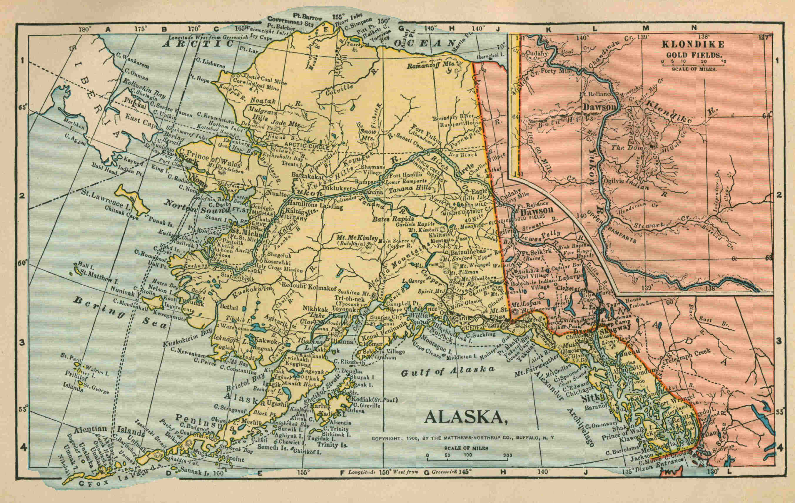
Map of Alaska.
The following is an English statement of the situation of the controversy at the time the Joint High Commission adjourned: "The adjournment of the Commission with nothing accomplished is fresh in all our memories. Nor is it easy to determine on whose shoulders lies the blame of this unfortunate break down. America has been blamed for her stubbornness in refusing to submit to an arbitration which should take into consideration the possession of the towns and settlements under the authority of the United States and at present under their jurisdiction; while they have also been charged with having made no concessions at all to Canada in the direction of allowing her free access to her Yukon possessions. I am enabled to say, however, in this latter respect the Americans have not been so stiff-necked as has been made to appear. Although it was not placed formally before the Commission, it was allowed clearly to be understood by the other side, that in regard to Skagway, America was prepared to make a very liberal concession. They were ready, that is, to allow of the joint administration of Skagway, the two flags flying side by side, and to allow of the denationalisation, or internationalisation as it might otherwise be termed, of the White Pass and the Yukon Railroad, now completed to Lake Bennett, and the only railroad which gives access to the Yukon. They were even prepared to admit of the passage of troops and munitions of war over this road, thus doing away with the Canadian contention that, should a disturbance occur in the Yukon, they are at present debarred from taking efficient measures to quell it. {9} This proposition, however, does not commend itself to the Canadians, whose main object, I think I am justified in saying, is to have a railroad route of their own from beginning to end, in their own territory, as far north as Dawson City. At one time, owing to insufficient information and ignorance of the natural obstacles in the way, they thought they could accomplish this by what was known as the Stikine route. They even went so far as to make a contract with Messrs. McKenzie and Mann to construct this road, the contractors receiving, as part of their payment, concessions and grants of territory in the Yukon, which would practically have given them the absolute and sole control of that district. The value of this to the contractors can hardly be overestimated. However, not only did the natural obstacles I have referred to lead to the abandonment of the scheme, but the Senate at Ottawa threw out the Bill which had passed through the Lower House, affording a striking proof that there are times when an Upper House has its distinct value in legislation. It has been suggested (though I am the last to confirm it) that it was the influence of the firm of railroad contractors, to whose lot it would probably fall to construct any new line of subsidised railway, which caused the Canadian Commission to reject the tentative American proposal regarding Skagway, and to put forward the counter claim to the possession of Pyramid Harbour (which lies lower down upon the west coast of the Lynn Canal), together with a two mile wide strip of territory reaching inland, containing the Chilcat Pass, and through it easy passage through the coast ranges, and so by a long line of railroad to Fort Selkirk, which lies on the Yukon River, to the south and east of Dawson City. It is said also, though of this I have no direct evidence, that the Canadians included the right to fortify Pyramid Harbour. It is not surprising that the Americans rejected this proposal, for they entered into the discussion convinced of the impossibility of accepting any arrangement which would involve the surrender of American settlements, and though it is not so large or important as Skagway or Dyea, Pyramid Harbour is nevertheless as much an American settlement as the two latter. I am bound to point out that just as the Dominion of Canada, as a whole, has a keener interest in this dispute than has the Home Government, so the Government of British Columbia is more closely affected by any possible settlement than is the rest of the Dominion. And British Columbia is as adverse to the Pyramid Harbour scheme as the United States themselves. This is due to the fact that when finished the Pyramid Harbour and Fort Selkirk railroad would afford no access to the British Columbia gold fields on Atlin Lake, which would still be reached only by way of Skagway and the White Pass, or by Dyea and the Chilcat Pass. But quite apart from this view of the matter, we may take it for granted that the United States will never voluntarily surrender any of their tide-water settlements, while the Canadian Government, on the other hand, are no more disposed to accept any settlement based on the internationalisation of Skagway, their argument probably being that, save as a temporary 'modus vivendi,' this would be giving away their whole case to their opponents." H. Townsend, The Alaskan Boundary Question (Fortnightly Review, September, 1899). Pending further negotiations on the subject, a "modus vivendi" between the United States and Great Britain, "fixing a provisional boundary line between the Territory of Alaska and the Dominion of Canada about the head of Lynn Canal," was concluded October 20, 1899, in the following terms: "It is hereby agreed between the Governments of the United States and of Great Britain that the boundary line between Canada and the territory of Alaska in the region about the head of Lynn Canal shall be provisionally fixed as follows without prejudice to the claims of either party in the permanent adjustment of the international boundary: In the region of the Dalton Trail, a line beginning at the peak West of Porcupine Creek, marked on the map No. 10 of the United States Commission, December 31, 1895, and on Sheet No. 18 of the British Commission, December 31, 1895, with the number 6500; thence running to the Klehini (or Klaheela) River in the direction of the Peak north of that river, marked 5020 on the aforesaid United States map and 5025 on the aforesaid British map; thence following the high or right bank of the said Klehini river to the junction thereof with the Chilkat River, a mile and a half, more or less, north of Klukwan,—provided that persons proceeding to or from Porcupine Creek shall be freely permitted to follow the trail between the said creek and the said junction of the rivers, into and across the territory on the Canadian side of the temporary line wherever the trail crosses to such side, and, subject to such reasonable regulations for the protection of the Revenue as the Canadian Government may prescribe, to carry with them over such part or parts of the trail between the said points as may lie on the Canadian side of the temporary line, such goods and articles as they desire, without being required to pay any customs duties on such goods and articles; and from said junction to the summit of the peak East of the Chilkat river, marked on the aforesaid map No. 10 of the United States Commission with the number 5410 and on the map No. 17 of the aforesaid British Commission with the number 5490. On the Dyea and Skagway Trails, the summits of the Chilcoot and White Passes. It is understood, as formerly set forth in communications of the Department of State of the United States, that the citizens or subjects of either Power, found by this arrangement within the temporary jurisdiction of the other, shall suffer no diminution of the rights and privileges which they now enjoy. The Government of the United States will at once appoint an officer or officers in conjunction with an officer or officers to be named by the Government of Her Britannic Majesty, to mark the temporary line agreed upon by the erection of posts, stakes, or other appropriate temporary marks." In his Annual Message to Congress, December 3, 1900, the President of the United States stated the situation as follows: "The work of marking certain provisional boundary points, for convenience of administration, around the head of Lynn Canal, in accordance with the temporary arrangement of October, 1899, was completed by a joint survey in July last. {10} The modus vivendi has so far worked without friction, and the Dominion Government has provided rules and regulations for securing to our citizens the benefit of the reciprocal stipulation that the citizens or subjects of either Power found by that arrangement within the temporary jurisdiction of the other shall suffer no diminution of the rights and privileges they have hitherto enjoyed. But however necessary such an expedient may have been to tide over the grave emergencies of the situation, it is at best but an unsatisfactory makeshift, which should not be suffered to delay the speedy and complete establishment of the frontier line to which we are entitled under the Russo-American treaty for the cession of Alaska. In this relation I may refer again to the need of definitely marking the Alaskan boundary where it follows the 141st meridian. A convention to that end has been before the Senate for some two years, but as no action has been taken I contemplate negotiating a new convention for a joint determination of the meridian by telegraphic observations. These, it is believed, will give more accurate and unquestionable results than the sidereal methods heretofore independently followed, which, as is known, proved discrepant at several points on the line, although not varying at any place more than seven hundred feet." ALEXANDRIA: Discovery of the Serapeion. See (in this volume) ARCHÆOLOGICAL RESEARCH: EGYPT: DISCOVERY OF THE SERAPEION. ALEXANDRIA: Patriarchate re-established. See (in this volume) PAPACY: A. D. 1896 (MARCH). ALIENS IMMIGRATION LAW, The Transvaal. See (in this volume) SOUTH AFRICA (THE TRANSVAAL): A. D. 1896-1897 (MAY-APRIL). ALPHABET, Light on the origin of the. See (in this volume) ARCHÆOLOGICAL RESEARCH: CRETE. AMATONGALAND: Annexed, with Zululand, to Natal. See (in this volume) AFRICA: A. D. 1897 (ZULULAND). AMERICA: The Projected Intercontinental Railway. See (in this volume) RAILWAY, THE INTERCONTINENTAL. AMERICA, Central. See (in this volume) CENTRAL AMERICA. AMERICAN ABORIGINES. See (in this volume) INDIANS, AMERICAN. AMERICAN REPUBLICS, The Bureau of the. "The idea of the creation of an international bureau, or agency, representing the Republics of the Western Hemisphere, was suggested to the delegates accredited to the International American Conference held in Washington in 1889-90, by the conference held at Brussels in May, 1888, which planned for an international union for the publication of customs tariffs, etc. … On March 29, 1890, the International American Conference, by a unanimous vote of the delegates of the eighteen countries there represented, namely: The Argentine Republic, Bolivia, Brazil, Chile, Colombia, Costa Rica, Ecuador, Guatemala, Haiti, Honduras, Mexico, Nicaragua, Paraguay, Peru, Salvador, United States, Uruguay, and Venezuela, provided for the establishment of an association to be known as 'The International Union of American Republics for the Prompt Collection and Distribution of Commercial Information,' which should be represented at the capital of the United States by a Bureau, under the title of 'The Bureau of the American Republics.' This organ, so to speak, of the independent governments of the New World was placed under the supervision of the Secretary of State of the United States, and was to continue in existence for a period of ten years, and, if found profitable to the nations participating in its advantages, it was to be maintained for successive periods of ten years indefinitely. At the first session of the Fifty-first Congress of the United States, that body, in an 'Act making appropriations for the support of the Diplomatic and Consular Service, etc.,' approved July 14, 1890, gave the President authority to carry into effect the recommendations of the Conference so far as he should deem them expedient, and appropriated $36,000 for the organization and establishment of the Bureau, which amount it had been stipulated by the delegates in the Conference assembled should not be exceeded, and should be annually advanced by the United States and shared by the several Republics in proportion to their population. … The Conference had defined the purpose of the Bureau to be the preparation and publication of bulletins concerning the commerce and resources of the American Republics, and to furnish information of interest to manufacturers, merchants, and shippers, which should be at all times available to persons desirous of obtaining particulars regarding their customs tariffs and regulations, as well as commerce and navigation." Bulletin of the Bureau of American Republics, June, 1898. A plan of government for the International Union, by an executive committee composed of representatives of the American nations constituting the Union, was adopted in 1896, but modified at a conference held in Washington, March 18, 1899. As then adopted, the plan of government is as follows: "The Bureau of the American Republics will be governed under the supervision of the Secretary of State of the United States, with the cooperation and advice of four representatives of the other Republics composing the International Union, the five persons indicated to constitute an Executive Committee, of which the Secretary of State is to be ex-officio Chairman, or, in his absence, the Acting Secretary of State. The other four members of the Executive Committee shall be called to serve in turn, in the alphabetical order of the official names of their nations in one of the four languages of the Union, previously selected by lot at a meeting of the representatives of the Union. At the end of each year the first of these four members shall retire, giving place to another representative of the Union, in the same alphabetical order already explained, and so on until the next period of succession." {11} "The interest taken by the various States forming the International Union of American Republics in the work of its organic bureau is evidenced by the fact that for the first time since its creation in 1890 all the republics of South and Central America are now [1899] represented in it. The unanimous recommendation of the International American Conference, providing for the International Union of American Republics, stated that it should continue in force during a term of ten years from the date of its organization, and no country becoming a member of the union should cease to be a member until the end of said period of ten years, and unless twelve months before the expiration of said period a majority of the members of the union had given to the Secretary of State of the United States official notice of their wish to terminate the union at the end of its first period, that the union should continue to be maintained for another period of ten years, and thereafter, under the same conditions, for successive periods of ten years each. The period for notification expired on July 14, 1899, without any of the members having given the necessary notice of withdrawal. Its maintenance is therefore assured for the next ten years." Message of the President of the United States. December 5, 1899. AMERICANISM: Pope Leo XIII. on opinions so called. See (in this volume) PAPACY: A. D. 1899 (JANUARY). AMNESTY BILL, The French. See (in this volume) FRANCE: A. D. 1900 (DECEMBER). ANARCHIST CRIMES: Assassination of Canovas del Castillo. See (in this volume) SPAIN: A. D. 1897 (AUGUST-OCTOBER). Assassination of the Empress of Austria. See (in this volume) AUSTRIA-HUNGARY: A. D. 1898 (SEPTEMBER). Assassination of King Humbert. See (in this volume) ITALY: A. D. 1899-1900; and 1900 (JULY-SEPTEMBER). ANATOLIAN RAILWAY, The. See (in this volume) TURKEY: A. D. 1899 (NOVEMBER). ANCON, The Treaty of. See (in this volume) CHILE: A. D. 1894-1900. ANDERSON, General Thomas M.: Correspondence with Aguinaldo. See (in this volume) UNITED STATES OF AMERICA: A. D. 1898 (JULY-AUGUST: PHILIPPINES). ANDRÉE, Salamon August: Arctic balloon voyage. See (in this volume) POLAR EXPLORATION, 1897, 1898, 1899, 1900-. ANGLO-AMERICAN POPULATION. See (in this volume) NINETEENTH CENTURY: EXPANSION. ANGONI-ZULUS, The. See (in this volume) BRITISH CENTRAL AFRICA PROTECTORATE. ANTARCTIC EXPLORATION. See (in this volume) POLAR EXPLORATION. ANTEMNÆ, Excavations at. See (in this volume) ARCHÆOLOGICAL RESEARCH: ITALY. ANTIGUA: Industrial condition. See (in this volume) WEST INDIES, THE BRITISH: A. D. 1897. ANTITOXINE, Discovery of. See (in this volume) SCIENCE, RECENT: MEDICAL AND SURGICAL. ANTI-IMPERIALISTS, The League of American. See (in this volume) UNITED STATES OF AMERICA: A. D. 1900 (MAY-NOVEMBER). ANTI-REVOLUTIONARY BILL, The German. See (in this volume) GERMANY: A. D. 1894-1895. ANTI-SEMITIC AGITATIONS. See (in this volume) AUSTRIA-HUNGARY: A. D. 1895-1896, and after; and FRANCE: A. D. 1897-1899, and after. ANTI-SEMITIC LEAGUE, Treasonable conspiracy of the. See (in this volume) FRANCE: A. D. 1899-1900 (AUGUST-JANUARY). APPORTIONMENT ACT. See (in this volume) UNITED STATES OF AMERICA: A. D. 1901 (JANUARY). ARBITRATION, Industrial: In New Zealand. See (in this volume) NEW ZEALAND: A. D. 1891-1900. ARBITRATION, Industrial: In the United States between employees and employers engaged in inter-state commerce. See (in this volume) UNITED STATES OF AMERICA: A. D. 1898 (JUNE). ARBITRATION, International: A. D. 1896-1900. Boundary dispute between Colombia and Costa Rica. See (in this volume) COLOMBIA: A. D. 1893-1900. ARBITRATION, International: A. D. 1897. Nicaragua and Costa Rica. See (in this volume) CENTRAL AMERICA (NICARAGUA-COSTA RICA): A. D. 1897. ARBITRATION, International: A. D. 1897-1899. Venezuela and Great Britain. Guiana boundary. See (in this volume) VENEZUELA: A. D. 1896-1899. ARBITRATION, International: A. D. 1898. Argentine Republic and Chile. See (in this volume) ARGENTINE REPUBLIC: A. D. 1898. ARBITRATION, International: A. D. 1898. Treaty between Italy and the Argentine Republic. See (in this volume) ARGENTINE REPUBLIC: A. D. 1898. ARBITRATION, International: A. D. 1899. The Treaty for the Pacific Settlement of International Disputes concluded at the Peace Conference at the Hague (Text). The Permanent Court created. See (in this volume) PEACE CONFERENCE. ARBITRATION, International: A. D. 1900. Brazil and French Guiana boundary dispute. See (in this volume) BRAZIL: A. D. 1900. ARBITRATION, International: A. D. 1900. Compulsory arbitration voted for at Spanish-American Congress. See (in this volume) SPAIN: A. D. 1900 (NOVEMBER). ARBITRATION TREATY, Great Britain and the United States. Its defeat. See (in this volume) UNITED STATES OF AMERICA: A. D. 1897 (JANUARY-MAY). ----------ARCHÆOLOGICAL RESEARCH: Start-------- ARCHÆOLOGICAL RESEARCH: The Oriental Field. Recent achievements and future prospects. "Three successive years have just added to the realm of Egyptian archaeology, not only the period of the first two dynasties, hitherto absolutely unrecognized from contemporary remains, but also a long prehistoric period. Assyriology likewise has lately been pushed back into antiquity with almost equal rapidity. Though the subjects will probably always have their limitations, yet the insight of scholars and explorers is opening up new vistas on all sides. … Our prospect for the future is bright. Egypt itself seems inexhaustible. Few of the cities of Babylonia and Assyria have yet been excavated, and each of them had its library and record office of clay-tablets as well as monuments in stone and bronze. In Northern Mesopotamia are countless sites still untouched; in Elam and in Armenia monuments are only less plentiful. {12} In Arabia inscriptions are now being read which may perhaps date from 1000 B. C. The so-called Hittite hieroglyphs still baffle the decipherer; but as more of the documents become known these will in all likelihood prove a fruitful source for the history of North Syria, of Cappadocia, and of Asia Minor throughout. Occasionally, too, though it is but rarely, an inscription in the Phaenician type of alphabet yields up important historical facts. When all is done, there is but scant hope that we shall be able to construct a consecutive history of persons and events in the ancient world. All that we can be confident of securing, at any rate in Egypt, is the broad outline of development and change, chronologically graduated and varied by occasional pictures of extraordinary minuteness and brilliancy." F. LL. Griffith, Authority and Archaeology Sacred and Profane, part 2, pages. 218-219 (New York: Charles Scribner's Sons). ARCHÆOLOGICAL RESEARCH: In Bible Lands: General results as affecting our knowledge of the ancient Hebrews. "The general result of the archaeological and anthropological researches of the past half-century has been to take the Hebrews out of the isolated position which, as a nation, they seemed previously to hold, and to demonstrate their affinities with, and often their dependence upon, the civilizations by which they were surrounded. Tribes more or less closely akin to themselves in both language and race were their neighbours alike on the north, on the east, and on the south; in addition to this, on each side there towered above them an ancient and imposing civilization,—that of Babylonia, from the earliest times active, enterprising, and full of life, and that of Egypt, hardly, if at all, less remarkable than that of Babylonia, though more self-contained and less expansive. The civilization which, in spite of the long residence of the Israelites in Egypt, left its mark, however, most distinctly upon the culture and literature of the Hebrews was that of Babylonia. It was in the East that the Hebrew traditions placed both the cradle of humanity and the more immediate home of their own ancestors; and it was Babylonia which, as we now know, exerted during many centuries an influence, once unsuspected, over Palestine itself. "It is true, the facts thus disclosed, do not in any degree detract from that religious pre-eminence which has always been deemed the inalienable characteristic of the Hebrew race: the spiritual intuitions and experiences of its great teachers retain still their uniqueness; but the secular institutions of the nation, and even the material elements upon which the religious system of the Israelites was itself constructed, are seen now to have been in many cases common to them with their neighbours. Thus their beliefs about the origin and early history of the world, their social usages, their code of civil and criminal law, their religious institutions, can no longer be viewed, as was once possible, as differing in kind from those of other nations, and determined in every feature by a direct revelation from Heaven; all, it is now known, have substantial analogies among other peoples, the distinctive character which they exhibit among the Hebrews consisting in the spirit with which they are infused and the higher principles of which they are made the exponent. … "What is called the 'witness of the monuments' is often strangely misunderstood. The monuments witness to nothing which any reasonable critic has ever doubted. No one, for instance, has ever doubted that there were kings of Israel (or Judah) named Ahab and Jehu and Pekah and Ahaz and Hezekiah, or that Tiglath-Pileser and Sennacherib led expeditions into Palestine; the mention of these (and such like) persons and events in the Assyrian annals has brought to light many additional facts about them which it is an extreme satisfaction to know: but it has only 'confirmed' what no critic had questioned. On the other hand, the Assyrian annals have shewn that the chronology of the Books of Kings is, in certain places, incorrect: they have thus confirmed the conclusion which critics had reached independently upon internal evidence, that the parts of these books to which the chronology belongs are of much later origin than the more strictly historical parts, and consequently do not possess equal value. "The inscriptions, especially those of Babylonia, Assyria, and Egypt, have revealed to us an immense amount of information respecting the antiquities and history of these nations, and also, in some cases, respecting the peoples with whom, whether by commerce or war, they came into contact: but (with the exception of the statement on the stele of Merenptah that 'Israel is desolated') the first event connected with Israel or its ancestors which they mention or attest is Shishak's invasion of Judah in the reign of Rehoboam; the first Israelites whom they specify by name are Omri and his son Ahab. There is also indirect illustration of statements in the Old Testament relating to the period earlier than this; but the monuments supply no 'confirmation' of any single fact recorded in it, prior to Shishak's invasion." S. R. Driver, Authority and Archaeology Sacred and Profane, part 1, pages 150-151 (New York: Charles Scribner's Sons). ARCHÆOLOGICAL RESEARCH: Babylonia: Earlier explorations in. For some account of the earlier archæological explorations in Babylonia and their results, See (in volume 1) BABYLONIA, PRIMITIVE; and (in volume 4) SEMITES. ARCHÆOLOGICAL RESEARCH: Babylonia: American exploration of the ruins of ancient Nippur. [Footnote: Quotations in this account from Professor Hilprecht's copyrighted reports in the "Sunday School Times" are used with permission from the publishers of that journal.] "In the summer of 1888, the University of Pennsylvania fully equipped and sent out the first American expedition to the northern half of the plains of Babylonia to effect a thorough exploration of the ruins of Nippur—the modern Niffer, or, more correctly, Nuffar—on the border of the unwholesome swamps of the Affej, and to undertake extensive excavations. A few intelligent citizens of Philadelphia had met in the house of Ex-Provost Dr. William Pepper, and formed 'The Babylonian Exploration Fund,' a short time before this with the purpose of effecting a systematic exploration of ancient Babylonia. What science owes to this unselfish undertaking can be adequately estimated only by posterity. … Two professors, Peters and Hilprecht, were entrusted with the management of the expedition, Dr. Peters as director, and Dr. Hilprecht as Assyriologist." H. V. Hilprecht, editor, Recent Research in Bible Lands, page 47. {13} Professor Hilprecht, who conducts for the "Sunday School Times" a most interesting and important department, in which the proceedings and principal results of archæological exploration in Bible Lands have been currently chronicled during several years past, gave, in that journal of December I, 1900, the following description of the scene and the historical importance of the ruins in which the excavations above mentioned have been carried on: "Nuffar is the modern Arabic name of an old Babylonian ruin situated about half-way between the Euphrates and Tigris, at the northeastern boundary of the great Affej swamps, which are formed by the regular annual inundations of the Euphrates. In a straight line, it is nearly eighty miles to the southeast from Baghdad. A large canal, now dry, and often for miles entirely filled with rubbish and sand, divides the ruins into two almost equal parts. On an average about fifty or sixty feet high, these ruins are torn up by frequent gulleys and furrows into a number of spurs and ridges, from the distance not unlike a rugged mountain range on the bank of the upper Tigris. In the Babylonian language, the city buried here was called Nippur. According to Jewish tradition, strongly supported by arguments drawn from cuneiform texts and archaeological objects found at the ruins themselves, Nippur was identical with the Biblical Calneh, mentioned in Genesis 10: 10, as one of the four great cities of the kingdom of Nimrod. It was therefore natural that the public in general should take a warm interest in our excavations at Nuffar. This interest grew considerably in religious circles when, a few years ago, I announced my discovery of the name of the 'river Chebar' in two cuneiform texts from the archives of Nippur. It became then evident that this 'river Chebar,' which hitherto could not be located, was one of the four or five large canals once bringing life and fertility to the fields of Nippur; that, furthermore, a large number of the Jewish captives carried away by Nebuchadrezzar after the destruction of Jerusalem were settled in the plains around this city; and that even Ezekiel himself, while admonishing and comforting his people, and holding out to them Jehovah's mercy and never-failing promise of a brighter future, stood in the very shadow of Babylonia's ancient national sanctuary, the crumbling walls of the great temple of Bêl at Nippur. The beginning and end of Old Testament history thus point to Nippur as the background and theater for the first and final acts in the great drama of divine selection and human rejection in which Israel played the leading role." In the same article, Professor Hilprecht indicated in a few words what was done at Nuffar by the first three of the four expeditions sent out from Philadelphia since 1888. "It was comparatively easy," he said, "to get a clear idea of the extent of the city and the life in its streets during the last six centuries preceding our era. Each of the four expeditions to Nuffar contributed its peculiar share to a better knowledge of this latest period of Babylonian history, particularly, however, the third and the present campaigns. But it was of greater importance to follow up the traces of a very early civilization, which, accidentally, we had met during our first brief campaign in 1889. By means of a few deep trenches, the second expedition, in the following year, had brought to light new evidence that a considerable number of ancient monuments still existed in the lower strata of the temple mound. The third expedition showed that the monuments, while numerous, are mostly very fragmentary, thereby offering considerable difficulties to the decipherer and historian. But it also showed that a number of platforms running through the temple mound, and made of baked bricks, frequently bearing inscriptions, enable us to fix the age of the different strata of this mound with great accuracy. The two lowest of these platforms found were the work of kings and patesis (priest-kings) of 4000-3800 B. C., but, to our great astonishment, they did not represent the earliest trace of human life at Nippur. There were not less than about thirty feet of rubbish below them, revealing an even earlier civilization, the beginning and development of which lie considerably before the times of Sargon the Great (3800 B. C.) and Narâm-Sin, who had been generally regarded as half-mythical persons of the first chapter of Babylonian history." Of the results of the work of those three expeditions of the University of Pennsylvania, and of the studies for which they furnished materials to Professor Hilprecht, Professor Sayce wrote with much enthusiasm in the "Contemporary Review" of January, 1897, as follows: "In my Hibbert Lectures on the 'Religion of the Ancient Babylonians' I had been led by a study of the religious texts of Babylonia to the conclusion that Nippur had been a centre from which Babylonian culture was disseminated in what we then regarded as prehistoric times. Thanks to the American excavations, what were prehistoric times when my Hibbert Lectures were written have now become historic, and my conclusion has proved to be correct. … For the first time in Babylonia they have systematically carried their shafts through the various strata of historical remains which occupy the site, carefully noting the objects found in each, and wherever possible clearing each stag away when once it had been thoroughly examined. The work began in 1888, about two hundred Arabs being employed as labourers. … The excavations at Nippur were carried deeply and widely enough not only to reveal the history of the city itself but also to open up a new vista in the forgotten history of civilised man. The history of civilisation has been taken back into ages which a short while since were still undreamed of. Professor Hilprecht, the historian of the expedition, upon whom has fallen the work of copying, publishing, and translating the multitudinous texts discovered in the course of it, declares that we can no longer 'hesitate to date the founding of the temple of Bel and the first settlements in Nippur somewhere between 6000 and 7000 B. C., possibly even earlier.' At any rate the oldest monuments which have been disinterred there belong to the fifth or sixth millennium before the Christian era. Hitherto we have been accustomed to regard Egypt as the land which has preserved for us the earliest written monuments of mankind, but Babylonia now bids fair to outrival Egypt. The earliest fixed date in Babylonian history is that of Sargon of Akkael and his son Naram-Sin. It has been fixed for us by Nabonidos, the royal antiquarian of Babylonia. In one of his inscriptions he describes the excavations he made in order to discover the memorial cylinders of Naram-Sin, who had lived '3200 years' before his own time. In my Hibbert Lectures I gave reasons for accepting this date as approximately correct. The recent discoveries at Niffer, Telloh, and other places have shown that my conclusion was justified. … {14} "Assyriologists have long had in their possession a cuneiform text which contains the annals of the reign of Sargon, and of the first three years of the reign of his son. It is a late copy of the original text, and was made for the library of Nineveh. Our 'critical' friends have been particularly merry over the credulity of the Assyriologists in accepting these annals as authentic. … So far from being unhistorical, Sargon and Naram-Sin prove to have come at the end of a long-preceding historical period, and the annals themselves have been verified by contemporaneous documents. The empire of Sargon, which extended from the Persian Gulf to the Mediterranean, was not even the first that had arisen in Western Asia. And the art that flourished under his rule, like the art which flourished in Egypt in the age of the Old Empire, was higher and more perfect than any that succeeded it in Babylonia. … Henceforward, Sargon and Naram-Sin, instead of belonging to 'the grey dawn of time,' must be regarded as representatives of 'the golden age of Babylonian history.' That they should have undertaken military expeditions to the distant West, and annexed Palestine and the Sinaitic Peninsula to the empire they created need no longer be a matter of astonishment. Such campaigns had already been undertaken by Babylonian kings long before; the way was well known which led from one extremity of Western Asia to the other. … "It is Mr. Haynes [Director of the explorations from 1893] who tells us that we are henceforth to look upon Sargon of Akkad as a representative of 'the golden age of Babylonian history,' and his assertion is endorsed by Professor Hilprecht. In fact, the conclusion is forced upon both the excavator and the palæographist. Professor Hilprecht, who, thanks to the abundant materials at his disposal, has been able to found the science of Babylonian palæography, tracing the development of the cuneiform characters from one stage of development to another, and determining the age of each successive form of writing, has made it clear to all students of Assyriology that many of the inscriptions found at Niffer and Telloh belong to a much older period than those of the age of Sargon. The palæographic evidence has been supplemented by the results of excavation. … As far back as we can penetrate, we still find inscribed monuments and other evidences of civilisation. It is true that the characters are rude and hardly yet lifted above their pictorial forms. They have, however, ceased to be pictures, and have already become that cursive script which we call cuneiform. For the beginnings of Babylonian writing we have still to search among the relics of centuries that lie far behind the foundation of the temple of Nippur. "The first king whom the excavations there have brought to light is a certain En-sag(sak)-ana who calls himself 'lord of Kengi' and conqueror of Kis 'the wicked.' Kengi—'the land of canals and reeds,' as Professor Hilprecht interprets the word—was the oldest name of Babylonia, given to it in days when it was still wholly occupied by its Sumerian population, and when as yet no Semitic stranger had ventured within it. The city of Kis (now El-Hy-mar) lay outside its borders to the north, and between Kis and Kengi there seems to have been constant war. … Nippur was the religious centre of Kengi, and Mul-lil, the god of Nippur, was the supreme object of Sumerian worship. … A king of Kis made himself master of Nippur and its sanctuary, and the old kingdom of Kengi passed away. The final blow was dealt by the son of the Sumerian high priest of the 'Land of the Bow.' Lugal-zaggi-si was the chieftain who descended from the north upon Babylonia and made it part of his empire. … Lugal-zaggi-si lived centuries before Sargon of Akkad in days which, only a year ago, we still believed to lie far beyond the horizon of history and culture. We little dreamed that in that hoar antiquity the great cities and sanctuaries of Babylonia were already old, and that the culture and script of Babylonia had already extended far beyond the boundaries of their motherland. The inscriptions of Lugal-zaggi-si are in the Sumerian language, and his name, like that of his father, is Sumerian also. … The empire of Lugal-zaggi-si seems to have passed away with his death, and at no long period subsequently a new dynasty arose at Ur. … According to Professor Hilprecht, this would have been about 4000 B. C. How long the first dynasty of Ur lasted we cannot tell. It had to keep up a perpetual warfare with the Semitic tribes of northern Arabia, Ki-sarra, 'the land of the hordes,' as it was termed by the Sumerians. Meanwhile a new state was growing up on the eastern side of the Euphrates in a small provincial city called Lagas, whose ruins are now known as Telloh. Its proximity to Eridu, the seaport and trading depot of early Babylonia, had doubtless much to do with its rise to power. At all events the kings of Telloh, whose monuments have been brought to light by M. de Sarzec, became continually stronger, and the dynasty of Lagas took the place of the dynasty of Ur. One of these kings, E-Anna-gin, at length defeated the Semitic oppressors of northern Chaldæa in a decisive battle and overthrew the 'people of the Land of the Bow.' … "The kings of Lagas represent the closing days of Sumerian supremacy. With Sargon and his empire the Semitic age begins. The culture of Chaldæa is still Sumerian, the educated classes are for the most part of Sumerian origin, and the literature of the country is Sumerian also. But the king and his court are Semites, and the older culture which they borrow and adopt becomes Semitised in the process. … For many generations Sumerians and Semites lived side by side, each borrowing from the other, and mutually adapting and modifying their own forms of expression. … Sumerian continued to be the language of religion and law—the two most conservative branches of human study—down to the age of Abraham. … The new facts that have been disinterred from the grave of the past furnish a striking confirmation of Professor Hommel's theory, which connects the culture of primitive Egypt with that of primitive Chaldæa, and derives the language of the Egyptians, at all events in part, from a mixed Babylonian language in which Semitic and Sumerian elements alike claimed a share. We now know that such a mixed language did once exist, and we also know that this language and the written characters by which it was expressed were brought to the shores of the Mediterranean and the frontiers of Egypt in the earliest age of Egyptian history." A. H. Sayce, Recent Discoveries in Babylonia (Contemporary Review, January, 1897). {15} The third of the Pennsylvania expeditions closed its work at Nippur in February, 1896. There was then an interval of three years before a fourth expedition resumed work at the ruins in February, 1899. In the "Sunday School Times" of April 29 and May 27, 1899, Professor Hilprecht (who did not go personally to Nuffar until later in the year) gave the following account of the friendly reception of the exploring party by the Arabs of the district, from whom there had been formerly much experience of trouble: "The Affej tribes, in whose territory the large mounds are situated, had carefully guarded the expedition's stronghold,—a mud castle half-way between the ruins and the marshes, which had been sealed and entrusted to their care before we quitted the field some years ago. They now gave to the expedition a hearty welcome, accompanied by shooting, shouting, dancing, and singing, and were evidently greatly delighted to have the Americans once more in their midst. In the presence of Haji Tarfa, their commander-in-chief, who was surrounded by his minor shaykhs and other dignitaries of the El-Hamza tribes, the former arrangements with the two shaykhs Hamid el-Birjud and Abud el-Hamid were ratified, and new pledges given for the security and welfare of the little party of explorers, the question of guards and water being especially emphasized. In accordance with the Oriental custom, the expedition showed its appreciation of the warm reception by preparing for their hosts in return a great feast, at which plenty of mutton and boiled rice were eaten by some fifty Arabs, and the old bond of friendship was cemented anew with 'bread and salt.'" … "Doubtless all the advantages resulting for the Affej Bed'ween and their allies from the presence of the Americans were carefully calculated by them in the three years (February, 1896-1899) that we had withdrawn our expedition from their territory. They have apparently found out that the comparatively large amount of money brought into their country through the wages paid to many Arabs employed as workmen, and through the purchase of milk, eggs, chicken, mutton, and all the other material supplied by the surrounding tribes for our camp, with its about two hundred and fifty persons, has done much to improve their general condition. The conviction has been growing with them that we have not come to rob them of anything to which they attach great value themselves, nor to establish a new military station for the Turkish government in order to gather taxes and unpaid debts. Every Arab engaged by the Expedition has been fairly treated, and help and assistance have always been given cheerfully and gratis to the many sick people who apply daily for medicine, suffering more or less during the whole year from pulmonary diseases, typhoid and malarial fevers, easily contracted in the midst of the extended marshes which they inhabit." In the "Sunday School Times" of August 5, in the same year, Professor Hilprecht reported: "The mounds of Nippur seem to conceal an almost inexhaustible treasure of inscribed cuneiform tablets, by means of which we are enabled to restore the chronology, history, religion, and the high degree of civilization, obtained at a very early date by the ancient inhabitants between the lower Euphrates and Tigris. More than 33,000 of these precious documents were found during the previous campaigns. Not less than 4,776 tablets have been rescued from February 6 to June 10 this year, averaging, therefore, nearly 1,200 'manuscripts in clay,' as we may style them, per month. About the fourth part of these tablets is in perfect condition, while a very large proportion of the remaining ones are good-sized fragments or tablets so fortunately broken that their general contents and many important details can be ascertained by the patient decipherer." In November, 1899, Professor Hilprecht started for the field, to superintend the explorations in person, and on the way he wrote to the "S. S. Times" (published December 13): "The deeper the trenches of the Babylonian Expedition of the University of Pennsylvania descend into the lower strata of Nippur, the probable site of the biblical Calneh, the more important and interesting become the results obtained. The work of clearing the northeastern wall of the high-towering temple of Bel was continued with success during the summer months. Particularly numerous were the inscribed vase fragments brought to light, and almost exclusively belonging to the pre-Sargonic period,—3800 B. C. and before. As I showed in the second part of Volume I of our official University publication, this fragmentary condition of the vases is due to the wilful destruction of the temple property by the victorious Elamitic hordes, who, towards the end of the third pre-Christian millennium, ransacked the Babylonian cities, extending their conquest and devastation even as far as the shores of the Mediterranean Sea (comp. Gen. 14). From the earliest historical period down to about 2200 B. C., when this national calamity befell Babylonia, the large temple storehouse, with its precious statues, votive slabs and vases, memorial stones, bronze figures, and other gifts from powerful monarchs and governors, had practically remained intact. What, therefore, is left of the demolished and scattered contents of this ancient chamber as a rule is found above the platform of Ur-Ninib (about 2500 B. C.), in a layer several feet thick and about twenty-five feet wide, surrounding the front and the two side walls of the temple. The systematic clearing and examination of this layer, and of the huge mass of ruins lying above it, occupied the attention of the expedition considerably in the past years, and was continued with new energy during the past six months." At the end of January, 1900, Professor Hilprecht arrived in Babylonia, and wrote some weeks later to the "Sunday School Times" (May 3): "As early as eleven years ago, the present writer pointed out that the extensive group of hills to the southwest of the temple of Bel must be regarded as the probable site of the temple library of ancient Nippur. About twenty-five hundred tablets were rescued from the trenches in this hill during our first campaign. Later excavations increased the number of tablets taken from these mounds to about fifteen thousand. But it was only within the last six weeks that my old theory could be established beyond any reasonable doubt. {16} During this brief period a series of rooms was exposed which furnished not less than over sixteen thousand cuneiform documents, forming part of the temple library during the latter half of the third millennium B. C. In long rows the tablets were lying on ledges of unbaked clay, serving as shelves for these imperishable Old Babylonian records. The total number of tablets rescued from different parts of the ruins during the present campaign amounts even now to more than twenty-one thousand, and is rapidly increased by new finds every day. The contents of this extraordinary library are as varied as possible. Lists of Sumerian words and cuneiform signs, arranged according to different principles, and of fundamental value for our knowledge of the early non-Semitic language of the country, figure prominently in the new 'find.' As regards portable antiquities of every description, and their archeological value, the American expedition stands readily first among the three expeditions at present engaged in the exploration of Ancient Babylonia and the restoration of its past history." Three weeks later he added: "The Temple Library, as indicated in the writer's last report, has been definitely located at the precise spot which, in 1889, the present writer pointed out as its most probable site. Nearly eighteen thousand cuneiform documents have been rescued this year from the shelves of a series of rooms in its southeastern and northwestern wings. The total number of tablets (mostly of a didactic character) obtained from the library up to date is from twenty-five thousand to twenty-six thousand tablets (whole and broken). In view, however, of more important other duties to be executed by this expedition before we can leave Nippur this year, and in consideration of the enormous amount of time and labor required for a methodical exploration of the whole mound in which it is concealed, I have recently ordered all the gangs of Arabic workmen to be withdrawn from this section of ancient Nippur, and to be set at work at the eastern fortification line of the city, close to the temple-complex proper. According to a fair estimate based upon actual finds, the unique history of the temple, and topographical indications, there must be hidden at least from a hundred thousand to a hundred and fifty thousand tablets more in this ancient library, which was destroyed by the invading Elamites about the time of Abraham's emigration from Ur of the Chaldees. Only about the twentieth part of this library (all of Dr. Haynes's previous work included) has so far been examined and excavated." In the same letter the Professor described the uncovering of one façade of a large pre-Sargonic palace—"the chief discovery," in his opinion, "of this whole campaign." "A thorough excavation of this large palace," he wrote, "will form one of the chief tasks of a future expedition, after its character, age, and extent have been successfully determined by the present one. Important art treasures of the Tello type, and literary documents, may reasonably be expected to be unearthed from the floor-level of its many chambers. It has become evident, from the large number of pre-Sargonic buildings, walls, and other antiquities discovered on both sides of the Shatt-en-Nil, that the pre-Sargonic Nippur was of by far greater extent than had been anticipated. This discovery, however, is only in strict accord with what we know from the cuneiform documents as to the important historical rôle which the temple of Bel ('the father of the gods'), as the central national sanctuary of ancient Babylonia, played at the earliest period, long before Babylon, the capital of the later empire, achieved any prominence." The work at Nippur was suspended for the season about the middle of May, 1900, and Professor Hilprecht, after his return to Philadelphia, wrote of the general fruits of the campaign, in the "Sunday School Times" of December 1: "As the task of the fourth and most recent expedition, just completed, I had mapped out, long before its organization, the following work. It was to determine the probable extent of the earliest pre-Sargonic settlement at ancient Nippur; to discover the precise form and character of the famous temple of Bêl at this earliest period; to define the exact boundaries of the city proper; if possible, to find one or more of the great city gates frequently mentioned in the inscriptions; to locate the great temple library and educational quarters of Nippur; to study the different modes of burial in use in ancient Babylonia; and to study all types and forms of pottery, with a view to finding laws for the classification and determination of the ages of vases, always excavated in large numbers at Nuffar. The work set before us has been accomplished. The task was great,—almost too great for the limited time at our disposal. … But the number of Arab workmen, busy with pickax, scraper, and basket in the trenches for ten to fourteen hours every day, gradually increased to the full force of four hundred. … In the course of time, when the nearly twenty-five thousand cuneiform texts which form one of the most conspicuous prizes of the present expedition have been fully deciphered and interpreted; when the still hidden larger mass of tablets from that great educational institution, the temple library of Calneh-Nippur, discovered at the very spot which I had marked for its site twelve years ago, has been brought to light,—a great civilization will loom up from past millenniums before our astonished eyes. For four thousand years the documents which contain this precious information have disappeared from sight, forgotten in the destroyed rooms of ancient Nippur. Abraham was about leaving his ancestral home at Ur when the great building in which so much learning had been stored up by previous generations collapsed under the ruthless acts of the Elamite hordes. But the light which begins to flash forth from the new trenches in this lonely mound in the desert of Iraq will soon illuminate the world again. And it will be no small satisfaction to know that it was rekindled by the hands of American explorers." {17} ARCHÆOLOGICAL RESEARCH: Babylonia: German exploration of the ruins of Babylon. An expedition to explore the ruins of Babylon was sent out by the German Orient Society, in 1899, under the direction of Dr. Koldewey, an eminent architect and archæologist, who had been connected with previous works of excavation done in Babylonia and northern Syria. In announcing the project, in the "Sunday School Times" of January 28, 1899, Professor Hilprecht remarked: "These extended ruins will require at least fifty years of labor if they are to be excavated as thoroughly and systematically as the work is done by the American expedition at Nippur, which has employed in its trenches never less than sixty, but frequently from two hundred to four hundred, Arabic workmen at the same time during the last ten years. Certain parts of the ruins of Babylon have been previously explored and excavated by Layard, Rawlinson, and the French expedition under Fresnel and Oppert, to which we owe the first accurate details of the topography of this ancient city." Writing somewhat more than a year later from Nippur, after having visited the German party at Babylon, Professor Hilprecht said of its work: "The chief work of the expedition during the past year was the exploration of the great ruin heap called El-Kasr, under which are hidden the remains of the palace of Nebuchadrezzar, where Alexander the Great died after his famous campaign against India. Among the few important antiquities so far obtained from this imposing mound of Ancient Babylon is a new Hittite inscription and a neo-Babylonian slab with an interesting cuneiform legend. Very recently, Dr. Koldewey, whose excellent topographical surveys form a conspicuous part of the results of the first year, has found the temple of the goddess Nin-Makh, so often mentioned in the building inscriptions of the neo-Babylonian rulers, and a little terra-cotta statue of the goddess. The systematic examination of the enormous mass of ruins covering Ancient Babylon will require several decenniums of continued hard labor. To facilitate this great task, a bill has been submitted to the German Reichstag requesting a yearly government appropriation of over fifteen thousand dollars, while at the same time application has been made by the German Orient Committee to the Ottoman Government for another firman to carry on excavations at Warka, the biblical Erech, whose temple archive was badly pillaged by the invading Elamites at about 2280 B. C." Some account of results from the uncovering of the palace of Nebuchadrezzar are quoted from "Die Illustrirte Zeitung" in the "Scientific American Supplement," December 16, 1899, as follows: "According to early Babylonian records, Nebuchadnezzar completed the fortifications of the city, begun by his father Narbolpolassar, consisting of a double inclosure of strong walls, the inner called Imgur-Bel ('Bel is gracious'), the outer Nemitti-Bel ('foundation of Bel'). The circumference of the latter according to Herodotus was 480 stades (55 miles), its height 340 feet, and its thickness 85 feet. At the inner and outer peripheries, one-story houses were built, between which was room enough for a chariot drawn by four horses harnessed abreast. When Koldewey cut through the eastern front of Al Kasr, he came upon a wall which was undoubtedly that described by Herodotus. The outer eastern shell was composed of burnt brick and asphalt, 24 feet in thickness; then came a filling of sand and broken stone 70½ feet in thickness, which was followed by an inner western shell of 43 feet thickness. The total thickness was, therefore, 137.5 feet. By dint of hard work this wall was cut through and the entrance to Nebuchadnezzar's palace laid bare. Koldewey and his men were enabled to verify the description given by Diodorus of the polychromatic reliefs which graced the walls of the royal towers and palaces. It still remains to be seen how trustworthy are the statements of other ancient historians. The city itself, as previous investigators have found, was adorned with many temples, chief among them Esaglia ('the high towering house'), temple of the city, and the national god Marduk (Merodach) and his spouse Zirpanit. Sloping toward the river were the Hanging Gardens, one of the world's seven wonders, located in the northern mound of the ruins of Babel. The temple described by Herodotus is that of Nebo, in Borsippa, not far from Babylon, which Herodotus included under Babylon and which the cuneiform inscriptions term 'Babylon the Second.' This temple, which in the mound of Birs Nimrûd is the most imposing ruin of Babylon, is called the 'eternal house' in the inscriptions; it was restored by Nebuchadnezzar with great splendor. In form, it is a pyramid built in seven stages, for which reason it is sometimes referred to as the 'Temple of the Seven Spheres of Heaven and Earth.' The Tower of Babel, described in Genesis x., is perhaps the same structure. It remains for the German expedition to continue its excavations in Nebuchadnezzar's palace." ARCHÆOLOGICAL RESEARCH: Babylonia: Discovery of an inscription of Nabonidos, the last of the Babylonian kings. "A discovery of the greatest importance has just been made by Father Scheil, who has for some time been exploring in Babylonia. In the Mujelibeh mound, one of the principal heaps of ruins in the 'enciente' of Babylon, he has discovered a long inscription of Nabonidos, the last of the Babylonian Kings (B. C. 555-538), which contains a mass of historical and other data which will be of greatest value to students of this important period of Babylonian history. The monument in question is a small 'stela' of diorite, the upper part of which is broken, inscribed with eleven columns of writing, and which appears to have been erected early in the King's reign. It resembles in some measure the celebrated India-House inscription of Nebuchadnezzar, but is much more full of historical matter. Its value may be estimated when it is stated that it contains a record of the war of revenge conducted by the Babylonians and their Mandian allies against Assyria, for the destruction of the city by Sennacherib, in B. C. 698; an account of the election and coronation of Nabonidos in B. C. 555, and the wonderful dream in which Nebuchadnezzar appeared to him; as well as an account of the restoration of the temple of the Moon god at Kharran, accompanied by a chronological record which enables us to fix the date of the so-called Scythian invasion. There is also a valuable reference to the murder of Sennacherib by his son in Tebet, B. C. 681." American Journal of Archœology, January-March, 1896. ARCHÆOLOGICAL RESEARCH: Persia: French exploration of the ruins of Susa, the capital of ancient Elam. "In 1897 an arrangement was completed between the French Government and the Shah of Persia by which the former obtained the exclusive right of archeological explorations in the latter's empire, coupled with certain privileges for the exportation of different kinds of antiquities that might be unearthed. Soon afterwards, M. J. de Morgan, late director of excavations in Egypt, who had made archeological researches in the regions east of the Tigris before, was placed at the head of a French expedition to Susa, the ancient capital of Elam, the upper strata of which had been successfully explored by M. Dieulafoy. {18} In the Babylonian cuneiform inscriptions Elam appears as the most terrible foe of the Babylonian empire from the earliest time: and the name of its capital, Susa, or Shâsha, was discovered by the present editor several years ago on a small votive object in agate, originally manufactured and inscribed in southern Babylonia, in the first half of the third pre-christian millennium, several hundred years afterwards carried away as part of their spoil by the invading Elamites, and in the middle of the fourteenth century B. C. recaptured, reinscribed, and presented to the temple of Nippur by King Kurigalzu, after his conquest of Susa. It was therefore evident that, if the same method of excavating was applied to the ruins of Susa as had been applied so successfully by the University of Pennsylvania's expedition in Nippur, remarkable results would soon be obtained, and amply repay all labor and money expended. M. de Morgan, accompanied by some engineers and architects, set hopefully to work, cutting his trenches more than fifty feet below the ruins of the Achæmenian dynasty. The first campaign, 1897-98, was so successful, in the discovery of buildings and inscribed antiquities, that in October of last year the French government despatched the Assyriologist Professor Scheil, in order to decipher the new cuneiform documents, and to report on their historical bearings. "Among the more important finds so far made, but not yet published, maybe mentioned over a thousand cuneiform tablets of the earlier period, a beautifully preserved obelisk more than five feet high, and covered with twelve hundred lines of Old Babylonian cuneiform writing. It was inscribed and set up by King Manishtusu, who left inscribed vases in Nippur and other Babylonian cities. A stele of somewhat smaller size, representing a battle in the mountains, testifies to the high development of art at that remote period. On the one end it bears a mutilated inscription of Narâm-Sin, son of Sargon the Great (3800 B. C.); on the other, the name of Shimti-Shilkhak, a well-known Elamitic king, and grandfather of the biblical Ariokh (Genesis 14). These two monuments were either left in Susa by the two Babylonian kings whose names they bear, after successful operations against Elam, or they were carried off as booty at the time of the great Elamitic invasion, which proved so disastrous to the treasure-houses and archives of Babylonian cities and temples [see above: BABYLONIA]. The latter is more probable to the present writer, who in 1896 ('Old Babylonian Inscriptions,' Part II, page 33) pointed out, in connection with his discussion of the reasons of the lamentable condition of Babylonian temple archives, that on the whole we shall look in vain for well-preserved large monuments in most Babylonian ruins, because about 2280 B. C. 'that which in the eyes of the national enemies of Babylonia appeared most valuable was carried to Susa and other places: what did not find favor with them was smashed and scattered on Babylonian temple courts.'" Prof. H. V. Hilprecht, Oriental Research (Sunday School Times, January 28, 1809). ARCHÆOLOGICAL RESEARCH: Egypt: Earlier explorations. For some account of earlier archæological explorations in Egypt, See, in volume 1, EGYPT. ARCHÆOLOGICAL RESEARCH: Egypt: Results of recent exploration. The opening up of prehistoric Egypt. The tomb of Mena. The funeral temple of Merenptah. Single mention of the people of Israel. "During all this century in which Egyptian history has been studied at first hand, it has been accepted as a sort of axiom that the beginnings of things were quite unknown. In the epitome of the history which was drawn up under the Greeks to make Egypt intelligible to the rest of the world, there were three dynasties of kings stated before the time of the great pyramid builders; and yet of those it has been commonly said that no trace remained. Hence it has been usual to pass them by with just a mention as being half fabulous, and then to begin real history with Senefern or Khufu (Cheops), the kings who stand at the beginning of the fourth dynasty, at about 4000 B. C. The first discovery to break up this habit of thought was when the prehistoric colossal statues of Min, the god of the city of Koptos, were found in my excavations in his temple. These had carvings in relief upon them wholly different from anything known as yet in Egypt, and the circumstances pointed to their being earlier than any carvings yet found in that country. In the same temple we found also statues of sacred animals and pottery which we now know to belong to the very beginning of Egyptian history, many centuries before the pyramids, and probably about 5000 B. C. or earlier. "The next step was the finding of a new cemetery and a town of the prehistoric people, which we can now date to about 5000 B. C., within two or three centuries either way. This place lay on the opposite side of the Nile to Koptos—that is to say, about 20 miles north of Thebes. At first we were completely staggered by a class of objects entirely different from any yet known in Egypt. We tried to fit them into every gap in Egyptian history, but found that it was impossible to put them before 3000 B. C. Later discoveries prove that they are really as old as 5000 B. C. They show a very different civilization from that of the Egyptians whom we already know—far less artistic, but in some respects even more skillful in mechanical taste and touch than the historical Egyptians. They built brick houses to live in, and buried their dead in small chambers sunk in the gravels of the water courses, lined with mats, and roofed over with beams. They show several points of contact with the early Mediterranean civilization, and appear to have been mainly north African tribes of European type. Their pottery, in its patterns and painting, shows designs which have survived almost unchanged unto the present day among the Kabyles of the Algerian Mountains. And one very peculiar type of pottery is found spread from Spain to Egypt, and indicates a widespread commercial intercourse at that remote day. The frequent figures upon the vases of great galley ships rowed with oars show that shipping was well developed then, and make the evidences of trading between different countries easy to be accepted. {19} "An of the above belongs to the age probably before 4700 B. C., which is the age given for the first historical king of Egypt by the Greek history of Manetho. A keystone of our knowledge of the civilization is the identification of the tomb of Mena, the first name in Egyptian history, the venerated founder of all the long series of hundreds of historic kings. This tomb, about 15 miles north of Thebes, was found by some Arabs, and shown to Dr. De Morgan, the director of the Department of Antiquities. It was a mass of about thirty chambers, built of mud brick and earth. Each chamber contained a different class of objects, one of stone vases, one of stone dishes, one of copper tools, one of water jars, etc. And among the things are carvings of lions and vases in rock crystal and obsidian, large hard-stone vases, slate palettes for grinding paint, pottery vases, and, above all, an ivory tablet with relief carvings which show the names of the king. Besides this, M. Amelineau has found sixteen tombs of this same general character at Abydos, which we can hardly now doubt belong to the early kings of the first three dynasties, and some four or five have been actually identified with the names of these kings in the Greek history. So now instead of treating the first three dynasties as half fabulous and saying that Egyptian art and civilization begin full blown at 4000 B. C., we have the clear and tangible remains of much of these early kings back to 4700 B. C., and a stretch of some centuries of the prehistoric period with a varied and distinctive civilization, well known and quite different from anything later, lying before 4700 B. C. To put the earlier part of this to 5500 B. C. is certainly no stretch of probability. … "We now pass entirely from these early times, with their fascinating insight into the beginnings of things, long before any other human history that we possess, until we reach down to what seems quite modern times in the record of Egypt, where it comes into contact with the Old Testament history. On clearing out the funereal temple of King Merenptah I found in that the upper half of a fine colossal statue of his, with all the colors still fresh upon it. As this son of Rameses the Great is generally believed to be the Pharaoh of the exodus, such a fine portrait of him is full of interest. Better even than that—I found an immense tablet of black granite over 10 feet high and 5 feet wide. It had been erected over two centuries before and brilliantly carved by an earlier king, whose temple was destroyed for materials by Merenptah. He took this splendid block and turned its face inward against the wall of his temple and carved the back of it with other scenes and long inscriptions. Most of it is occupied with the history of his vanquishing the Libyans, or North African tribes, who were then invading Egypt. But at the end he recounts his conquests in Syria, among which occurs the priceless passage: 'The people of Israel are spoiled; they have no seed.' This is the only trace yet found in Egypt of the existence of the Israelites, the only mention of the name, and it is several centuries earlier than the references to the Israelite and Jewish kings in the cuneiform inscriptions of Assyria. "What relation this has to our biblical knowledge of the Israelites is a wide question, that has several possible answers. Without entering on all the openings, I may here state what seems to me to be the most probable connection of all the events, though I am quite aware that fresh discoveries might easily alter our views. It seems that either all the Israelites did not go into Egypt or else a part returned and lived in the north of Palestine before the exodus that we know, because we here find Merenptah defeating Israelites at about 1200 B. C. Of his conquest and of those of Rameses III in Palestine there are no traces in the biblical accounts, the absence of which indicates that the entry into Canaan took place after 1160 B. C., the last war of Rameses III. Then the period of the Judges is given in a triple record—(l) of the north, (2) of the east of the Jordan, (3) of Ephraim and the west; and these three accounts are quite distinct and never overlap, though the history passes in succession from one to another. Thus the whole age of Judges is but little over a century. And to this agree the priestly genealogies stretching between the tabernacle and temple periods. "Leaving now all the monumental age, we come lastly to the evidences of the Christian period, preserved in the papyri or miscellaneous waste papers left behind in the towns of the Roman times. Last winter my friends, Mr. Grenfell and Mr. Hunt, cleared out the remains of the town Behnesa, about 110 miles south of Cairo. There, amid thousands of stray papers, documents, rolls, accounts, and all the waste sweepings out of the city offices, they found two leaves which are priceless in Christian literature—the leaf of Logia, or sayings of Jesus, and the leaf of Matthew's Gospel. The leaf of the Logia is already so widely known that it is needless for me to describe it. … The leaf of Matthew's Gospel is of great interest in the literary history of the Gospels. Hitherto we have had no manuscripts older than the second great ecclesiastical settlement under Theodosius. Now we have a piece two ages earlier—before the first settlement of things under Constantine at the council of Nicea. Here, in the middle of the third century, we find that the beginning of the Gospel, the most artificial, and probably the latest, part, the introductory genealogy and account of the Nativity, was exactly in its present form. This gives us the greatest confidence that the Gospel as we have it dates from the time of the great persecutions. Such are some of the astonishing and far-reaching results that Egypt has given us within three years past." W. M. Flinders Petrie, Recent Research in Egypt (Sunday School Times, February 19, 1898.) In a later article, contributed to the "Popular Science Monthly," Professor Petrie has described more fully the results of recent exploration in Egypt, especially with reference to the discovery and study of prehistoric remains. The following are passages from the article: "The great stride that has been made in the last six years is the opening up of prehistoric Egypt, leading us back some 2000 years before the time of the pyramid builders. Till recently nothing was known before the age of the finest art and the greatest buildings, and it was a familiar puzzle how such a grand civilization could have left no traces of its rise. This was only a case of blindness on the part of explorers. Upper Egypt teems with prehistoric remains, but, as most of what appears is dug up by plunderers for the market, until there is a demand for a class of objects, very little is seen of them. Now that the prehistoric has become fashionable, it is everywhere to be seen. The earlier diggers were dazzled by the polished colossi, the massive buildings, the brilliant sculptures of the well-known historic times, and they had no eyes for small graves, containing only a few jars or, at best, a flint knife. {20} "The present position of the prehistory of Egypt is that we can now distinguish two separate cultures before the beginning of the Egyptian dynasties, and we can clearly trace a sequence of manufactures and art throughout long ages before the pyramid builders, or from say 6000 B. C., giving a continuous history of 8000 years for man in Egypt. Continuous I say advisedly, for some of the prehistoric ways are those kept up to the present time. In the earliest stages of this prehistoric culture metal was already used and pottery made. Why no ruder stages are found is perhaps explained by the fact that the alluvial deposits of the Nile do not seem to be much older than 8000 years. The rate of deposit is well known—very closely one metre in a thousand years—and borings show only eight metres thick of Nile mud in the valley. Before that the country had enough rain to keep up the volume of the river, and it did not drop its mud. It must have run as a rapid stream through a barren land of sand and stones, which could not support any population except paleolithic hunters. With the further drying of the climate, the river lost so much velocity that its mud was deposited, and the fertile mud flats made cultivation and a higher civilization possible. At this point a people already using copper came into the country. … "The second prehistoric civilization seems to have belonged to a people kindred to that of the first age, as much of the pottery continued unchanged, and only gradually faded away. But a new style arose of a hard, buff pottery, painted with patterns and subjects in red outline. Ships are represented with cabins on them, and rowed by a long bank of oars. The use of copper became more general, and gold and silver appear also. … Though this civilization was in many respects higher than that which preceded it, yet it was lower artistically, the figures being ruder and always flat, instead of in the round. … "The separation of these two different ages has been entirely reached by the classification of many hundreds of tombs, the original order of which could be traced by the relation of their contents. … The material for this study has come entirely from excavations of my own party at Nagada (1895), Abadiyeh, and Hu (1899); but great numbers of tombs of these same ages have been opened without record by Dr. de Morgan (1896-1897), and by French and Arab speculators in antiquities. The connection between these prehistoric ages and the early historic times of the dynastic kings of Egypt is yet obscure. The cemeteries which would have cleared this have unhappily been looted in the last few years without any record, and it is only the chance of some new discoveries that can be looked to for filling up the history. "We can at least say that the pottery of the early kings is clearly derived from the later prehistoric types, and that much of the civilization was in common. But it is clear that the second prehistoric civilization was degrading and losing its artistic taste for fine work before the new wave of the dynastic or historic Egyptians came in upon it. These early historic people are mainly known by the remains of the tombs of the early kings, found by M. Amelineau at Abydos (1896-1899), and probably the first stage of the same race is seen in the rude colossi of the god Min, which I found at Koptos (1894). … In these great discoveries of the last few years we can trace at least three successive peoples, and see the gradual rise of the arts, from the man who was buried in his goat skins, with one plain cup by him, up to the king who built great monuments and was surrounded by most sumptuous handiwork. We see the rise of the art of exquisite flint flaking, and the decline of that as copper came more commonly into use. We see at first the use of signs, later on disused by a second race, and then superseded by the elaborate hieroglyph system of the dynastic race. … "Turning now to the purely classical Egyptian work, the principal discoveries of the last few years have given us new leading examples in every line. The great copper statue of King Pepy, with his son, dates from before 3000 B. C. It is over life size, and entirely wrought in hammered copper, showing a complete mastery in metal work of the highest artistic power. … Many of the royal temples of the 19th dynasty at Thebes were explored by the English in 1896. The Ramesseum was completely examined, through all the maze of stone chambers around it. But the most important result was the magnificent tablet of black granite, about 10 feet high and 5 wide, covered on one side with an inscription of Amen Hotep III, and on the other side with an inscription of Merenptah. The latter account, of about 1200 B. C., mentions the war with the 'People of Israel'; this is the only naming of Israel on Egyptian records, and is several centuries earlier than any Assyrian record of the Hebrews. … "One of the most important results of historical Egyptian times is the light thrown on prehistoric Greek ages. The pottery known as 'Mykenæan' since the discoveries of Schliemann in the Peloponnesus was first dated in Egypt at Gurob in 1889; next were found hundreds of vase fragments at Tell el Amarna in 1892; and since then several Egyptian kings' names have been found on objects in Greece, along with such pottery. The whole of this evidence shows that the grand age of prehistoric Greece, which can well compare with the art of classical Greece, began about 1600 B. C., was at its highest point about 1400 B. C., and became decadent about 1200 B. C., before its overthrow by the Dorian invasion. Besides this dating, Greece is indebted to Egypt for the preservation of the oldest texts of its classics." W. M. Flinders Petrie, Recent Years of Egyptian Exploration (Appleton's Popular Science Monthly, April, 1900). Still later, in an address at the annual meeting of the Egypt Exploration Fund, November 7, 1900, Professor Petrie summed up with succinctness the gains to our knowledge of early man from the later researches in Egypt. "How many controversies," he said, "had waged over Manetho! And now from the Royal tombs of Abydos we had seen and handled this summer the drinking bowls and furniture of the Kings of the first dynasty, even the property of Menes himself, the first King of United Egypt. The early Kings, whom we had scarcely believed in, even Mena who had been proclaimed a mythical version of the Cretan Minos and the Indian Manu, came now before us as real and as familiarly as the Kings of the 30th dynasty or of Saxon England; and never before had so remote a period been brought so completely before us as it had been in the work this year at Abydos. {21} And how did Manetho and the State history of Seti bear the test? Five Kings we could already identify out of the eight recorded for the first dynasty. Those five are proved to have been recorded in their correct order, although the time of the first dynasty was so remote from even that of Seti that all the names had become slightly altered by transmission. It was to be remembered that the first dynasty was older to Seti than the Exodus was to us. Now that we were no longer afraid of our own rashness in assigning anything to a date before the fourth dynasty, and could deal with the earliest periods back to the first entry of agricultural man into Egypt, we could see more of the perspective of history. We saw palæolithic man scattering his massive flint weapons until the age of Nile mud (beginning about 7000 B. C.) made agriculture possible, and a Caucasian race ousted the palæolithic folks, whose portraits were left us in the figures found in the earliest graves. We saw this oldest race of man to have been of the Hottentot type, but even more hairy than the Hottentot, with the traces of his original Northern habitation not yet wiped off by tropical suns. Then we saw a rapidly rising civilization already knowing metals linked with the modern Kabyle both by bodily formation and by existing products. Next after some dozen generations we could trace strong Eastern or Semitic influence, which carried on this civilization to a higher point in many respects; and then decay set in and the first cycle that we could trace was completed. The next cycle began with the entry of the dynastic race from the Red Sea, possessing the elements of hieroglyphic writing and far more artistic sense and power than the earlier people. In some three or four centuries they had gradually conquered and invaded all the races scattered through Egypt—long-haired, short-haired, bearded and unbearded, clothed and unclothed; and the first King of all Egypt, who founded his new capital at the mouth of the valley, was Mena. The era of consolidation which preceded him was stated by Manetho as the dynasty of ten Kings of Abydos, who reigned for 300 years; it was a time of rapidly increasing civilization, during which most of the main features of Egyptian language, life, and art were stamped for 5,000 years to come. From the Royal tombs of Abydos we could see now how this art rose to its finest age in the middle of the first dynasty, and was decaying and becoming cheaper and more common by the end of that time. Probably we should see that this cycle was fading when some new impetus gave birth to the colossal ages of the pyramid builders. That grand period we now see to have been the third cycle of civilization and art, which was renewed again and again until we might see in the brilliance of the Fatimite dynasty the seventh of the great eras of Egypt. Such was the wider aspect of human history which the work solely of English exploration in Egypt now put before us. It might be safely said that there had never been a greater extension of knowledge of man's past in any decade than the discoveries of the last five years had unfolded. Details yet awaited us, but the main lines were all marked out, and their work of the future was to complete the picture of which we now had the full extent before us. What, now, would occupy the coming winter was the exploration of the remaining Royal tombs." ARCHÆOLOGICAL RESEARCH: Egypt: Discovery of a fragment of the Logia, or Sayings of Jesus. During the winter of 1896-1897, Messrs. Bernard P. Grenfell and Arthur S. Hunt conducted excavations for the Egypt Exploration Fund on the site of Oxyrhynchus, which was a flourishing city in the time of Roman rule in Egypt. Large quantities of papyri were found in the rubbish heaps of the town, and among them one fragment of special and remarkable interest,—as thus described by the discoverers, in a brief report, entitled "Sayings of Our Lord," published by the Egypt Exploration Fund in 1897: "The document in question is a leaf from a papyrus book containing a collection of Logia or Sayings of our Lord, of which some, though presenting several novel features, are familiar, others are wholly new. It was found at the very beginning of our work upon the town, in a mound which produced a great number of papyri belonging to the first three centuries of our era, those in the immediate vicinity of our fragment belonging to the second and third centuries. This fact, together with the evidence of the handwriting, which has a characteristically Roman aspect, fixes with certainty 300 A. D. as the lowest limit for the date at which the papyrus was written. The general probabilities of the case, the presence of the usual contractions found in biblical MSS., and the fact that the papyrus was in book, not roll, form, put the first century out of the question, and made the first half of the second unlikely. The date therefore probably falls within the period 150-300 A. D. More than that cannot be said with any approach to certainty. … The fragment measures 5¾X3¾ inches, but its height was originally somewhat greater, as it is unfortunately broken at the bottom." The following is a translation of the fragmentary sayings inscribed on the leaf: "… and then shalt thou see clearly to cast out the mote that is in thy brother's eye." "Jesus saith, Except ye fast to the world, ye shall in no wise find the kingdom of God; and except ye keep the sabbath, ye shall not see the Father." "Jesus saith, I stood in the midst of the world, and in the flesh was I seen of them, and I found all men drunken, and none found I athirst among them, and my soul grieveth over the sons of men, because they are blind in their heart. …" "Jesus saith, Wherever there are … and there is one … alone, I am with him. Raise the stone and there thou shalt find me, cleave the wood and there am I." "Jesus saith, A prophet is not acceptable in his own country, neither doth a physician work cures upon them that know him." "Jesus saith, A city built upon the top of a high hill, and stablished, can neither fall nor be hid." {22} ARCHÆOLOGICAL RESEARCH:Egypt: New discoveries in the tombs of the Valley of the Kings. In the Valley of the Kings, which extends along the west bank of the Nile, in the Libyan Mountains, opposite Luxor, M. Loret, director of the Egyptian explorations, discovered in 1898 the tombs of Thutmosis III. and Amenophis II., and in the following year made the more important discovery of the tomb of Thutmosis I., "the real founder of the eighteenth dynasty, who made Egypt one of the great empires of the ancient world." Professor Steindorf of the University of Leipsic, writing of this discovery to Professor Hilprecht of the University of Pennsylvania, remarked that its special importance "lies in the fact that Thutmosis I, the earliest king of the eighteenth dynasty, was also the first ruler to depart from the ancient custom of the Pharaohs, that of building in the desert lowland pyramidal tombs. For himself he had a tomb hewn out of rock in the mountains. His predecessor, Amenophis I, according to custom, built his tomb in the plain, near the present site of Drah-abul-negge, as we know from written records. Thutmosis I, on the contrary, chose for his last dwelling-place the lonely and majestic valley in the Libyan Mountains. For centuries the Pharaohs followed his example, and during the eighteenth, nineteenth, and twentieth dynasties were built those magnificent sepulchers which in Roman times were still among the greatest curiosities of ancient Thebes. … "Chief among the articles that Mr. Loret found in the tomb is a remarkably well-preserved papyrus containing texts from the Book of the Dead, with colored pictures finely executed; also a chest in which were kept a draught-board, with a full set of draughtmen, and some garlands; likewise fruit, food, poultry, and beef. The last-mentioned articles, being intended for the sustenance of the dead, each one was wrapped in linen and enclosed in a wooden case, exactly corresponding to its form. Thirteen large earthen beer jars, most of which, with their seals, stood there unmarred, and a large number of other vessels, had contained the beverages necessary for the refreshment of the dead. Weapons, among others two artistically wrought leathern quivers containing arrows, and two beautiful armchairs, completed this strange stock of equipments. The most remarkable piece of all is a large and beautifully preserved couch, the like of which has never been found in any other tomb. It consists of a quadrangular wooden frame, overspread with a thick rush mat, and over this were stretched three layers of linen with a life-size figure of the god of death, Osiris, drawn upon the outer layer. The figure itself was smeared with some material intended to make the under layer waterproof. Over this, mingled with some adhesive substance, soil had been spread, in which barley was planted. The grains had sprouted, and had grown to the height of from two and a half to three inches. The whole, therefore, represented a couch whereon the dead Osiris lay figured in greensward. Verily, a striking poetical idea, the resurrection of the dead symbolized by the picture of the barley springing up. The whole tomb, with its numerous equipments, furnishes a very important contribution to the history of the methods of burial among the ancient Egyptians." Sunday School Times, July 8, 1899. ARCHÆOLOGICAL RESEARCH: Egypt: Fall of eleven columns of the great temple at Karnak. "From Professor Georg Steindorff, of the University of Leipsic, comes the following: 'In the covered colonnade of the great temple at Karnak extensive restorations have lately been undertaken, rendered necessary by a most deplorable accident, which, about a year ago, befell this grandest of all Egyptian edifices. It occurred on the morning of October 3, 1899, in the colonnade which was built by Ramses I, Sethos I, and Ramses II, and which is doubtless familiar to all in engravings and photographs. In the northeastern part of this structure as many as eleven immense columns fell, and were totally wrecked, while several others are leaning over so that they might fall at any time. By this event the magnificent structure has been utterly ruined, and it now presents a dreary aspect. The cause of this catastrophe has not been definitely ascertained. The first thought was of an earthquake, but nothing of the sort was experienced elsewhere in Egypt on the morning of the day above mentioned. It is more likely that during the thirty-two hundred years of the building's existence, the material used in its construction had greatly deteriorated, and that this fact increased the possibility of a collapse. Then, also, in the main hall during recent years, the work of excavation and restoration was carried on with little regard for the dilapidated condition of the temple, which was weakened rather than strengthened by this work. But especially for the last four years, during the inundation of the Nile, the hall, by artificial means, has been flooded in order to extract and remove the salt which had formed. By this periodical flooding and drying of the ground the foundations have been very badly damaged. This, according to Dr. Borchardt, is the prime cause of the ruin. First the ground gave way under a column, which then toppled, and, in falling, brought down the others with it. "We must recognize the zeal with which the Egyptian Government, especially the department of Egyptian Antiquities, with its Director-General, Professor Maspero, came to the rescue of the ill-fated edifice. To prevent further catastrophe, they first proceeded to remove the architraves from five of the endangered columns, and to reduce the height of the columns to about twenty feet. This was accomplished by filling with sand that portion of the hall in which the columns stood, and then rolling the separate parts down the inclined plane formed by the sand. The north portion of the pylon terminating the colonnade toward the east—that is, toward the Nile—had badly suffered by the disaster. There were cracks in it so large as to cause the fear that it might some day collapse. After prompt and thorough work this danger also was obviated. Later on the ruins of the eleven fallen columns are to be removed, and the foundations of the hall examined. Then everything possible will be done to make the ground solid, and the attempt will be made to erect again the ruined columns. But whether the beautiful colonnade will ever resume its former appearance, whether it will ever again make upon the visitor such an overpowering impression as formerly, may well be a matter of serious doubt. Ancient Thebes has lost one of its most beautiful monuments.'" Sunday School Times, December 1, 1900. ARCHÆOLOGICAL RESEARCH: Egypt: Discovery of the Serapeion at Alexandria. "The excavations by Dr. Botti, the Director of the Alexandrian Museum, in the neighborhood of Pompey's Pillar, have resulted in the discovery of the Serapeion, where the last of the great libraries of Alexandria was preserved. An elaborate account of his researches, with an admirable plan, has been given by the discoverer in a memoir on 'L'Acropole d'Alexandrie et le Sérapeum,' presented to the Archæological Society of Alexandria. … Dr. Botti was first led to make his explorations by a passage in the orator Aphthonios, who visited Alexandria about A. D. 315." American Journal of Archœology, January-arch, 1896. {23} ARCHÆOLOGICAL RESEARCH: Crete: Recent explorations. Supposed discovery of the Palace of Minos and the Cretan Labyrinth. Fresh light on prehistoric Greece and the origin of the alphabet. Results of extraordinary importance have been already obtained from explorations in Crete, carried on during 1899 and 1900 by the British School at Athens, under the direction of Mr. D. G. Hogarth, and by Mr. Arthur J. Evans, of the Ashmolean Museum, working with the aid of a small Cretan Exploration Fund, raised in England. The excavations of both parties were carried on at Knossos, but the latter was the most fortunate, having opened the site of a prehistoric palace which is yielding remarkable revelations of the legendary age in Crete. In a communication to the "London Times" of October 31, 1900, Mr. Evans gave the following account of the results so far as then obtained: "The discoveries made at Knossos throw into the shade all the other exploratory campaigns of last season in the Eastern Mediterranean, by whatever nationality conducted. It is not too much to say that the materials already gathered have revolutionized our knowledge of prehistoric Greece, and that to find even an approach to the results obtained we must go back to Schliemann's great discovery of the Royal tombs at Mycenae. The prehistoric site, of which some two acres have now been uncovered at Knossos, proves to contain a palace beside which those of Tiryns and Mycenae sink into insignificance. By an unhoped-for piece of good fortune the site, though in the immediate neighbourhood of the greatest civic centres of the island in ancient, medieval, and modern times, had remained practically untouched for over 3,000 years. At but a very slight depth below the surface of the ground the spade has uncovered great courts and corridors, propylaea, a long succession of magazines containing gigantic store jars that might have hidden the Forty Thieves, and a multiplicity of chambers, pre-eminent among which is the actual throne-room and council-chamber of Homeric kings. The throne itself, on which (if so much faith be permitted to us) Minos may have declared the law, is carved out of alabaster, once brilliant with coloured designs and relieved with curious tracery and crocketed arcading which is wholly unique in ancient art and exhibits a strange anticipation of 13th century Gothic. In the throne-room, the western entrance gallery, and elsewhere, partly still adhering to the walls, partly in detached pieces on the floors, was a series of fresco paintings, excelling any known examples of the art in Mycenaean Greece. A beautiful life-size painting of a youth, with a European and almost classically Greek profile, gives us the first real knowledge of the race who produced this mysterious early civilization. Other frescoes introduce us to a lively and hitherto unknown miniature style, representing, among other subjects, groups of women engaged in animated conversation in the courts and on the balconies of the Palace. The monuments of the sculptor's art are equally striking. It may be sufficient to mention here a marble fountain in the shape of a lioness's head with enamelled eyes, fragments of a frieze with beautifully cut rosettes, superior in its kind to anything known from Mycenae; an alabaster vase naturalistically copied from a Triton shell; a porphyry lamp with graceful foliation supported on an Egyptianising lotus column. The head and parts of the body of a magnificent painted relief of a bull in gesso duro are unsurpassed for vitality and strength. "It is impossible here to refer more than incidentally to the new evidence of intercourse between Crete and Egypt at a very remote period supplied by the Palace finds of Knossos. It may be mentioned, however, as showing the extreme antiquity of the earlier elements of the building that in the great Eastern Court was found an Egyptian seated figure of diorite, broken above, which can be approximately dated about 2000 B. C. Below this again extends a vast Stone Age settlement which forms a deposit in some places 24 ft. in thickness. "Neither is it possible here to dwell on the new indications supplied by some of the discoveries in the 'House of Minos' as to the cult and religious beliefs of its occupants. It must be sufficient to observe that one of the miniature frescoes found represents the façade of a Mycenaean shrine and that the Palace itself seems to have been a sanctuary of the Cretan God of the Double Axe, as well as a dwelling place of prehistoric kings. There can be little remaining doubt that this huge building with its maze of corridors and tortuous passages, its medley of small chambers, its long succession of magazines with their blind endings, was in fact the Labyrinth of later tradition which supplied a local habitation for the Minotaur of grisly fame. The great figures of bulls in fresco and relief that adorned the walls, the harem scenes of some of the frescoes, the corner stones and pillars marked with the labrys or double axe—the emblem of the Cretan Zeus, explaining the derivation of the name 'Labyrinth' itself—are so many details which all conspire to bear out this identification. In the Palace-shrine of Knossos there stands at last revealed to us the spacious structure which the skill of Daedalus is said to have imitated from the great Egyptian building on the shore of Lake Moeris, and with it some part at least of his fabled masterpieces still clinging to the walls. "But, brilliant as are the illustrations thus recovered of the high early civilization of the City of Minos and of the substantial truth of early tradition, they are almost thrown into the shade by a discovery which carries back the existence of written documents in the Hellenic lands some seven centuries beyond the first known monuments of the historic Greek writing. In the chambers and magazines of the Palace there came to light a series of deposits of clay tablets, in form somewhat analogous to the Babylonian, but inscribed with characters in two distinct types of indigenous prehistoric script—one hieroglyphic or quasi-pictorial, the other linear. The existence of a hieroglyphic script in the island had been already the theme of some earlier researches by the explorer of the Palace, based on the more limited material supplied by groups of signs on a class of Cretan seal-stones, and the ample corroboration of the conclusions arrived at was, therefore, the more satisfactory. These Cretan hieroglyphs will be found to have a special importance in their bearing on the origin of the Phoenician alphabet. {24} "But the great bulk of the tablets belonged to the linear class, exhibiting an elegant and much more highly-developed form of script, with letters of an upright and singularly European aspect. The inscriptions, over 1,000 of which were collected, were originally contained in coffers of clay, wood, and gypsum, which had been in turn secured by clay seals impressed with finely-engraved signets and counter-marked and counter-signed by controlling officials in the same script while the clay was still wet. The clay documents themselves are, beyond doubt, the Palace archives. Many relate to accounts concerning the Royal Arsenal, stores, and treasures. Others, perhaps, like the contemporary cuneiform tablets, refer to contracts or correspondence. The problems attaching to the decipherment of these clay records are of enthralling interest, and we have here locked up for us materials which may some day enlarge the bounds of history." In an earlier communication to "The Times" (September 15), Mr. Evans had explained more distinctly the importance of the clay tablets found at Knossos, as throwing light on the origin of the alphabet: "In my excavation of the pre-historic Palace at Knossos," he wrote, "I came upon a series of deposits of clay tablets, representing the Royal archives, the inscriptions on which belong to two distinct systems of writing—one hieroglyphic and quasi-pictorial; the other for the most part linear and much more highly developed. Of these the hieroglyphic class especially presents a series of forms answering to what, according to the names of the Phoenician letters, we must suppose to have been the original pictorial designs from which these, too, were derived. A series of conjectural reconstructions of the originals of the Phoenician letters on this line were in fact drawn out by my father, Sir John Evans, for a lecture on the origin of the alphabet given at the Royal Institution in 1872, and it may be said that two-thirds of these resemble almost line for line actual forms of Cretan hieroglyphics. The oxhead (Aleph), the house (Beth), the window (He), the peg (Vau), the fence (Cheth), the hand (Yod) seen sideways, and the open palm (Kaph), the fish (Nun), the post or trunk (Samekh), the eye (Ain), the mouth, (Pe), the teeth (Shin), the cross-sign (Tau), not to speak of several other probable examples, are all literally reproduced. "The analogy thus supplied is indeed overwhelming. It is impossible to believe that, while on one side of the East Mediterranean basin these alphabetic prototypes were naturally evolving themselves, the people of the opposite shore were arriving at the same result by a complicated process of selection and transformation of a series of hieratic Egyptian signs derived from quite different objects. The analogy with the Cretan hieroglyphic forms certainly weighs strongly in favour of the simple and natural explanation of the origin of the Phoenician letters which was held from the time of Gesenius onwards, and was only disturbed by the extremely ingenious, though over-elaborate, theory of De Rougé." At the annual meeting of the subscribers to the British School at Athens, held in London, October 30, 1900, Mr. Hogarth, the Director, spoke with great enthusiasm of the significance of the Cretan discoveries already made, and of the promise of enlarged knowledge which they gave. He said: "The discovery made 25 years ago [by Schliemann] that no barbarians, but possessors of a very high and individual culture, preceded the Hellenic period in Greece—a culture which could not but have affected the Hellenic—had been developed in various ways since. It had been established that this culture had had a very long existence and development; it covered completely a large geographical area; it developed various local characteristics in art production which seemed to be gathered again into one by the typical art of Mycenae. But the most important historical points remained obscure. Where was the original home of this new civilization; what family did the race or races belong to; of what speech were they and what religions; what was the history of their societies and art during their dominance, and what became of them after? Neither mainland Greece nor the Aegean islands answered these. But there were two unknown quantities, Crete and Asia Minor, with Rhodes. One of these we have now attacked. Crete by its great size and natural wealth, its position, and its mythologic fame was bound to inform us of much. It is too early to say that the questions will all be answered by Crete, but already we have much light. The discovery of written documents and of shrines has told us more than any other evidence of the origin and family. The Knossos frescoes show us the racial type; the Dictaean, Cave, and Knossos houses illuminate the religion. New arts have been discovered, and the relation to Egypt and Asia are already far better understood. It remains now to find the early tombs, and clear the lower stratum of the Palace ruins at Knossos, to know more of the earliest Cretan race, to explore the cast or 'Eteocretan' end of the island, to obtain light on the language and relations to Egypt and Asia, and to investigate the 'Geometric' period, which is the transition to the Hellenic." Commenting in another place on the discoveries in Crete, Mr. Hogarth has pointed out their effect in modifying the ideas heretofore entertained of the importance of Phoenician influence in the rise of European civilization. "For many years now," he writes, "we have had before our eyes two standing protests against the traditional claim of Phoenicia to originate European civilization, and those protests come from two regions which Phoenician influence, travelling west, ought first to have affected, namely, Cyprus and Asia Minor. In both these regions exist remains of early systems of writing which are clearly not of Phoenician descent. Both the Cypriote syllabic script and the 'Hittite' symbols must have been firmly rooted in their homes before ever the convenient alphabet of Sidon and Tyre was known there. And now, since Mr. Evans has demonstrated the existence of two non-Phoenician systems of writing in Crete also, the use of one of which has been proved to extend to the Cyclades and the mainland of Greece, it has become evident that we have to deal in south-eastern Europe, as well as in Cyprus or Asia Minor, with a non-Phoenician influence of civilization which, since it could originate that greatest of achievements, a local script, was quite powerful enough to account by itself also for the local art. {25} "Those who continue to advocate the Phoenician claim do not seem sufficiently to realize that nowadays they have to take account neither only of the Homeric age nor only of even half a millennium before Homer, but of an almost geologic antiquity. Far into the third millennium B. C. at the very least, and more probably much earlier still, there was a civilization in the Aegean and on the Greek mainland which, while it contracted many debts to the East and to Egypt, was able to assimilate all that it borrowed, and to reissue it in an individual form, expressed in products which are not of the same character with those of any Eastern civilization that we know." D. G. Hogarth, Authority and Archaeology Sacred and Profane, part 2, pages 237-238 (New York: Charles Scribner's Sons). "During the past season, Evans, discoverer of the now famous early Cretan systems of writing, Halbherr and other Italians, as well as the French, have been proving what was already foreshadowed, that in Crete we find in its purest form and in all its historic and racial phases that Mediterranean civilization,—Pelasgic and Achæan,—that culminated in Tiryns and Mykenae. We now see that Homer sings of the closing years of a culture that dates back of the 'Trojan 'War' at least for fifteen hundred years. Crete is found to be covered with ruined Pelasgic cities, surrounded by gigantic polygonal walls, crowned by acropoli, adorned with royal palaces, defended by forts, connected by artificial highways, and with necropoli of vaulted tombs like those discovered by Schliemann at Mykenae. Already the royal palaces and libraries are being unearthed at Cnossos and 'Goulâs' with sculptures and decoration of the most novel description and early date. A literature in an unknown tongue and in undeciphered scripts is being found, to puzzle scholars as much perhaps as the Hittite and Etruscan languages. Some day these 'Pelasgic' documents will disclose the secrets of a neglected civilization and fill up the gap between early Eastern and Hellenic cultures." A. L. Frothingham, Jr., Archæological Progress (International Monthly, December, 1900). ARCHÆOLOGICAL RESEARCH: India: Discovery of the birthplace, tomb and relics of Gautama Buddha, See (in this volume) BUDDHA. ARCHÆOLOGICAL RESEARCH: Troy: Later researches on the site. "Dr. Doerpfeld finished in 1894 the exploration which he had begun in 1893 on the site of the excavations of Schliemann at Hissarlik (Troia). It appears to be established that Schliemann, carried away by his zeal, had overlooked the very end which he wished to attain, and that the burnt city, which he thought to be the real Troia, is a more ancient foundation going back beyond the year 2000 B. C. M. Doerpfeld discerned, in one of the layers of ruins (discovered but disregarded by Schliemann), a city which must be the Ilios of Priam contemporaneous with the Mykenai of Agamemnon; he removed the surrounding walls, the towers, and some of the houses that filled it. It is to be understood that this little acropolis, analogous to that of Tiryns, is not the whole of the city but simply its citadel, which Homer called 'Pergamos.' It was surrounded, lower down, by a city reserved for the habitation of the common people, some traces of which also have been found." American Journal of Archœology, 1896. ARCHÆOLOGICAL RESEARCH: Italy: Excavations at Antemnæ disclose what early Rome was probably like. "We can show what the earliest Rome was, the Rome of Romulus on the Palatine, and how it grew to be the City of the Seven Hills. The City itself, crowded with the wrecks of twenty-five centuries, preserves to-day few memorials of its earliest age; but excavations made on two sites, one close to Rome, one a little further north in Etruria, explain the process very clearly. The traveller who approaches Rome by the Via Salaria sees, just where Tiber and Anio join, a modern fort on an isolated rock. Here was Antemnae, destroyed (according to legend) by Roman jealousy very soon after Rome itself was founded. The legend seems to be true, at least in substance. On this hilltop excavations have shown a little village within a wall of stone: it had its temple and senate-house, its water-cistern, and square huts, thatched or timbered, for dwelling-houses. The relics found there shew that the site was abandoned, never to be again inhabited, about the time at which the legend fixes the fall of Antemnae. Here we have Rome's earliest rival. From the rival we may guess what the earliest Rome was like on the Palatine rock, and what all the little Italian towns were in their infancy." F. Haverfield, Authority and Archaeology Sacred and Profane, part 2, pages 302-303 (New York: Charles Scribner's Sons). ARCHÆOLOGICAL RESEARCH: Italy: The Etruscans. "During the decade which is now ending, archaeology has thrown some light on this strange people. Researches in North Italy prove that it never entered the Peninsula from the north. Researches in Etruria itself prove that the earliest Etruscan civilization resembled that which prevailed in the Eastern Mediterranean in the last days of the Aegean period. After all, the old legends were right. The ancients told how the Etruscans came from the east: archaeological evidence is now accumulating to confirm the legends. Precisely when they came or why is still obscure, nor can we identify them yet with any special tribe in pre-historic Greece, Pelasgian or other. Probably they were driven from their old homes, like the Phoenicians who built Carthage and the Phocaeans who built Marseilles." F. Haverfield, Authority and Archaeology Sacred and Profane, part 2, page 305 (New York: Charles Scribner's Sons). ARCHÆOLOGICAL RESEARCH: Italy: Sunken Roman vessels in Lake Nemi. "A discovery during 1895 which made a great sensation throughout Italy, was that of the famous Roman vessels which had been sunk for so many centuries at the bottom of Lake Nemi, the existence of which has been known or suspected ever since the fifteenth century, notwithstanding many sceptics." American Journal of Archœology July-September, 1896. ARCHÆOLOGICAL RESEARCH: Syria: Ruined cities of the Roman Province. An important exploration of ruined cities in the old Roman provinces of Syria and Arabia was conducted by an American archæological expedition organized in 1899. Mr. Howard Crosby Butler, of Princeton, was in charge of the studies made in architecture, sculpture and archæological matters generally; Professor William K. Prentice devoted attention to classical inscriptions, of which a great number were found, while Semitic inscriptions were the subjects of the study of Dr. Enno Littmann, of the University of Halle. The ruins of thirty-three cities, nearly all of them evident places of large population in their day, were visited in regions now too bare of productive soil to support even the small nomadic population of the present day. "The desert conditions have preserved the cities intact as they stood at the time when they appear to have been abandoned, in the beginning of the seventh century." Some account of the expedition and its work is given in the "New York Tribune" of February 3, 1901. ----------ARCHÆOLOGICAL RESEARCH: End-------- {26} ARCTIC EXPLORATION, Recent. See (in this volume) POLAR EXPLORATION. ----------ARGENTINE REPUBLIC: Start-------- ARGENTINE REPUBLIC: A. D. 1895. Census. "According to the census, the number of persons in the Argentine Republic on May 10, 1895, was 4,042,990; the estimated number of Argentines outside the boundaries of the Republic on that day is placed at 50,000, thus making the total population 4,092,990." Of this population 663,854 is in the city of Buenos Ayres. "The increase in the population between September 15, 1869 (the last census), and May 10, 1895 (the date on which the present census was taken), has been 2,218,776, equivalent to an increase of 120 per cent, or an annual increase of 4.6 per cent. The urban population of the Republic has increased 1,045,944. … It is estimated that there are 345,393 foreigners in the city of Buenos Ayres, and that the total number of foreigners in the Republic is about 1,000,000. … Among the Argentine portion of the population, the females exceed the males in number, while it is estimated that two-thirds of the foreign population are males." United States Consular Reports, November, 1896, page 438. ARGENTINE REPUBLIC: A. D. 1895. Resignation of President Peña. President Saenz Peña having refused to issue, at the request of Congress, a decree of amnesty, extended to all persons implicated in the last revolution, his Cabinet resigned (January 16), and he found it impossible to form another. Thereupon the President himself resigned his office, on the 22d of January, and his resignation was accepted by the Congress. Señor Uriburu was elected President on the following day, and promptly issued the desired decree. ARGENTINE REPUBLIC: A. D. 1898. Settlement of boundary dispute with Chile. Election of President. "A long unsettled dispute as to the extended boundary between the Argentine Republic and Chile, stretching along the Andean crests from the southern border of the Atacama Desert to Magellan Straits, nearly a third of the length of the South American continent, assumed an acute stage in the early part of the year, and afforded to this Government occasion to express the hope that the resort to arbitration, already contemplated by existing conventions between the parties, might prevail despite the grave difficulties arising in its application. I am happy to say that arrangements to this end have been perfected, the questions of fact upon which the respective commissioners were unable to agree being in course of reference to Her Britannic Majesty for determination. A residual difference touching the northern boundary line across the Atacama Desert, for which existing treaties provided no adequate adjustment, bids fair to be settled in like manner by a joint commission, upon which the United States Minister at Buenos Aires has been invited to serve as umpire in the last resort." Message of the President of the United States of America, December, 1898. The arbitration of the United States Minister, Honorable William I. Buchanan, proved successful in the matter last referred to, and the Atacama boundary was quickly determined. In June, 1898, General Julio Roca was elected President and assumed the office in October. In July a treaty of arbitration was concluded with the government of Italy, which provides that there shall be no appeal from the decision of the arbitrators. ----------ARGENTINE REPUBLIC: End-------- ARGON, The Discovery of. See (in this volume) SCIENCE, RECENT: CHEMISTRY AND PHYSICS. ARICA, The question concerning. See (in this volume) CHILE: A. D. 1894-1900. ARMENIA: A. D. 1895-1899. Revolt against Turkish oppression. Massacres and atrocities of the conflict. Final concessions. See (in this volume) TURKEY: A. D. 1895; 1896 (JANUARY-MARCH); 1896 (AUGUST); 1899 (OCTOBER). ARMENIA: A. D. 1896. Attack of Armenian revolutionists on the Ottoman Bank and subsequent massacre of Armenians in Constantinople. See (in this volume) TURKEY; A. D. 1896 (AUGUST). ARMIES, European and American: Their numbers and cost compared. See (in this volume) WAR BUDGETS. ARMY ADMINISTRATION, American: Investigation of. See (in this volume) UNITED STATES OF AMERICA: A. D. 1898-1899. ARMY CANTEEN, Abolition of the American. See (in this volume) UNITED STATES OF AMERICA: A. D. 1901 (FEBRUARY). ARMY, United States: Act to increase to 100,000 men. See (in this volume) UNITED STATES OF AMERICA: A. D. 1901 (FEBRUARY). ASHANTI: British occupation of the country. Rising of the tribes. Siege and relief of Kumassi. In 1895, King Prempeh, of Ashanti, provoked a second expedition of British troops against his capital, Kumassi, or Coomassie, by persistence in slave-catching raids and in human sacrifices, and by other violations of his treaty engagements. For some account of the former expedition See, in volume 2, ENGLAND: A. D. 1873-1880) Late in the year a strong force was organized in Gold Coast Colony, mostly made up of native troops. It marched without resistance to Kumassi, which it entered on the 17th of January, 1896. Prempeh made complete submission, placing his crown at the feet of the Governor of the Gold Coast; but he was taken prisoner to Sierra Leone. A fort was built, and garrisoned in the center of the town, and the country was then definitely placed under British protection, politically attached to the Gold Coast Colony. It submitted quietly to the practical conquest until the spring of 1900, when a fierce and general rising of the tribes occurred. It was said at the time that the outbreak was caused by efforts of the British to secure possession of a "golden stool" which King Prempeh had used for his throne, and which had been effectually concealed when Kumassi was taken in 1896; but this has been denied by Sir Frederic Hodgson, the Governor of the Gold Coast. "The 'golden stool,'" he declared, "was only an incident in the affair and had nothing to do with the cause of the rising, which had been brewing for a long time. {27} In his opinion the Ashantis had been preparing ever since the British occupation in 1896 to reassert their independence." The Governor was, himself, in Kumassi when the Ashantis first attacked it, on the 25th of March, and he has given an account of the desperate position in which the few British officials, with their small native garrison and the refugees whom they tried to protect, were placed. "Our force," said Sir Frederic Hodgson, "consisted of only some 200 Hausas, while there is reason to believe that we had not less than 15,000 Ashantis surrounding us. In addition to our own force we had to protect some 3,500 refugees, chiefly Mahomedan traders, Fantis, and loyal Kumassis, none of whom we were able to take into the fort, where every available bit of space was required for military purposes. It was heartrending to see the efforts of these poor people to scale the walls or break through the gate of the fort, and we had to withdraw the Hausas from the cantonments and draw a cordon round the refugees. It is impossible to describe the horror of the situation with these 3,500 wretched people huddled together without shelter under the walls of the fort. That same night a tornado broke over Kumassi, and the scene next morning with over 200 children was too terrible for words. Afterwards they were able to arrange shelters for themselves." Near the end of April, two small reinforcements from other posts reached Kumassi; but while this strengthened the numbers for defence, it weakened the food supply. Taking stock of their food, the besieged decided that they could hold out until June 23, and that if the main body then marched out, to cut, if possible, their way through the enemy, leaving a hundred men behind, the latter might keep the fort until July 15. This, accordingly, was done. On the 23d of June Governor Hodgson, with all but 100 men, stole away from Kumassi, by a road which the Ashantis had not guarded, and succeeded in reaching the coast, undergoing great hardships and dangers in the march. Meantime, an expedition from Cape Coast Castle was being energetically prepared by Colonel Sir J. Willcocks, who overcame immense difficulties and fought his way into Kumassi on Ju]y 15, the very day on which the food-supply of the little garrison was expected to give out. The following account of his entry into Kumassi is from Colonel Willcocks' official report: "Forming up in the main road, we marched towards Kumassi, a mile distant, the troops cheering wildly for the Queen and then followed silence. No sound came from the direction of the fort, which you cannot see till quite close. For a moment the hideous desolation and silence, the headless bodies lying everywhere, the sickening smell, &c., almost made one shudder to think what no one dared to utter—'Has Kumassi fallen? Are we too late?' Then a bugle sound caught the ear—'the general salute'—the tops of the towers appeared, and again every man in the column, white and black, broke into cheers long sustained. The brave defenders had at last seen us; they knew for hours' past from the firing growing ever nearer that we were coming, yet they dared not open their only gate; they perforce must wait, for even as we appeared the enemy were making their last efforts to destroy the outlying buildings, and were actually setting them on fire until after dark, when a party of 100 men went out and treated them to volleys and cleared them out. If I have gone too fully into details of the final scene, the occasion was one that every white man felt for him comes perhaps but once, and no one would have missed it for a kingdom." ASPHYXIATING SHELLS: Declaration against. See (in this volume) PEACE CONFERENCE. ASSASSINATIONS: Of President Barrios. See (in this volume) CENTRAL AMERICA (GUATEMALA): A. D. 1897-1898. Of President Borda. See (in this volume) URUGUAY: A. D. 1896-1899. Of Canovas del Castillo. See (in this volume) SPAIN: A. D. 1897 (AUGUST-OCTOBER). Of Empress Elizabeth of Austria. See (in this volume) AUSTRIA-HUNGARY: A. D. 1898 (SEPTEMBER). Of Governor Goebel. See (in this volume) KENTUCKY: A. D. 1895-1900. Of President Heureaux. See (in this volume) DOMINICAN REPUBLIC: A. D. 1899. Of King Humbert. See (in this volume) ITALY: A. D. 1899-1900; and 1900 (JULY-SEPTEMBER). Of Professor Mihaileano. See (in this volume) BALKAN AND DANUBIAN STATES. Of Nâsr-ed-din, Shah of Persia. See (in this volume) PERSIA: A. D. 1896. Of M. Stambouloff. See (in this volume) BALKAN AND DANUBIAN STATES (BULGARIA). ASSIOUT, Nile barrage at. See (in this volume) EGYPT: A. D. 1898-1901. ASSOCIATIONS BILL, The French. See (in this volume) FRANCE: A. D. 1901. ASSOUAN. Nile barrage at. See (in this volume) EGYPT: A. D. 1898-1901. ASSUMPTIONIST FATHERS, Dissolution of the Society of the. See (in this volume) FRANCE: A. D. 1899-1900 (AUGUST-JANUARY). ATACAMA, The question concerning. See (in this volume) CHILE: A. D. 1894-1900. ATBARA, Battle of the. See (in this volume) EGYPT: A. D. 1897-1898. ATHENS: A. D. 1896. The revival of Olympic games. As the result of a movement instituted in France by the Baron de Coubertin, an interesting attempt to give athletic sports the spirit and semblance of the ancient Olympic games was made at Athens in the spring of 1896. A number of wealthy Greeks in different parts of the world joined generously in the undertaking, one gentleman especially, M. Averoff, of Alexandria, bearing the cost of a restoration in marble of the stadium at Athens, for the occasion. The games were held in April, from the 6th to the 15th, and were witnessed by a great number of people. Besides Greek competitors, there were 42 from Germany, 23 from England, 21 from America, 15 from France. The great event of the occasion was the long foot-race from Marathon to Athens, which was won by a young Greek. The U. S. Consul at Athens, writing of the reconstruction of the ancient stadium for the games, described the work as follows: {28} "The stadium may be described as an immense open air amphitheater constructed in a natural ravine, artificially filled in at the end. It is in the shape of an elongated horseshoe. The spectators, seated upon the sloping sides of the ravine, look down into the arena below, which is a little over 600 feet in length and about 100 feet wide at the widest part. … The stadium, as rebuilt for the games, will consist of (1) the arena, bounded by a marble curbing, surmounted by an iron railing adorned with Athenian owls; (2) a walk between this curbing and the first row of seats; (3) a low retaining wall of marble on which rests the first row of seats, the entire row being of marble; (4) the seats; (5) the underground tunnel. In addition to these features there will be an imposing entrance, a surrounding wall at the top of the hill, and two supporting walls at the entrance. As far as possible, in the reconstruction of the stadium, the old portions will be used, where these are in a sufficient state of preservation, and an effort will be made to reproduce, as nearly as practicable, the ancient structure. The seats at present will not all be made of pentelic marble, as there is neither time nor money for such an undertaking. At the closed end of the arena, seventeen rows will be made of pentelic marble, as well as the first row all the way around. The remaining rows up to the first aisle are being constructed of Pincus stone. These will accommodate 25,000 seated spectators. From this aisle to the top will be placed wooden benches for 30,000 seated spectators. Add to these standing room for 5,000, and we have the holding capacity of the stadium 60,000 without crowding." United States Consular Reports, March, 1896, pages 353-354. ATLANTA: A. D. 1895. The Cotton States and International Exposition. An important exposition, named as above, was held with great success at Atlanta, Georgia, from the 18th of September until the end of the year 1895. The exhibits from Mexico and many of the Central and South American States were extensive and interesting; but the main interest and value of the exposition were in its showing of the industrial resources of the Southern States of the American Union, and of the recent progress made in developing them. AUSGLEICH, The. See (in this volume) AUSTRIA-HUNGARY: FINANCIAL RELATIONS; and A. D. 1897 (OCTOBER-DECEMBER). AUSTRAL ISLANDS: Annexation to France. The Austral or Tubuai Islands were formally annexed to France by the Governor of Tahiti, on the 21st of August, 1900. ----------AUSTRALIA. Start-------- AUSTRALIA: Recent extensions of Democracy in the Australian Colonies and New Zealand. Social experiments. "The five colonies of the Australian continent, Tasmania, and New Zealand constitute seven practically independent commonwealths under the British crown. Australians and New Zealanders have therefore been able to develop their countries along their own lines, and have surpassed all other Anglo-Saxon nations in the number and variety of functions which the state is called upon to perform. … The railways almost without exception, and all the telegraph and telephone lines, are in the hands of the community. In the few cases in which there is private ownership of railways, a particular line was demanded at a certain time, and the government were not then in a position to borrow the funds required for its construction. Western Australia has recently purchased the entire property of one of the two private undertakings in the colony. A mass of sanitary and industrial legislation also has been placed upon the statute book. "Again, South Australia, Victoria, Western Australia, and New Zealand lend money to settlers at low rates of interest; South Australia sells its wines in London; Queensland facilitates the erection of sugar mills; Victoria and South Australia have given a bonus upon the exportation of dairy produce; South Australia, New Zealand, and Victoria receive the produce, grade and freeze it free of charge, or at a rate which barely covers the expenses; Victoria contributes toward the erection of butter factories; Victoria and New Zealand have subsidized the mining industry; and Western Australia has adopted a comprehensive scheme for the supply of water to the Coolgardie gold fields. In all the colonies the national system of primary education is compulsory and undenominational. In South Australia, Victoria, Queensland, and New Zealand it is also free. In the other colonies fees are charged, which may be remitted wholly or partly if parents are unable to pay them. Assistance is given in most cases for the promotion of secondary, technical, and university education. New Zealand and South Australia have appointed public trustees. New Zealand has long possessed a department of life insurance. "Finally, … New Zealand has adopted a system of old-age pensions. A pension of seven shillings a week is to be given to every person above the age of sixty-five years, provided he or she has lived in the colony for twenty-five years, and is able to pass a certain test in regard to sobriety and general good conduct. … In South Australia direct taxation takes two forms. There is an income tax at the rate of four and a half pence in the pound up to £800, and of six-pence in the pound above £800 of taxable amount resulting from personal exertions, and at the rate of ninepence and one shilling in the pound respectively on incomes from property. Incomes between £125 and £425 enjoy exemption on £125 of the amount. Again, there is a tax on the unimproved value of land of one half-penny in the pound up to, and one penny above, the capital value of £5000. … "Similar taxation is to be found in New Zealand, and includes both a progressive income tax and a tax on land values which is more highly graduated than that of South Australia. … All improvements are excluded from the assessment of the taxable amount. … If the owner of the property is dissatisfied with the assessment of the government, he can call upon them to buy it of him at their own valuation. In only one case has such an extreme step been taken; and it is pleasant to find that it has resulted in an annual profit of nearly five per cent upon the outlay, and that the land which formerly gave employment to a few shepherds is now occupied by a large number of thriving settlers. {29} I may add that when the government deem that an estate is not being developed as it should be by its owners, they are authorized by statute to purchase it—by negotiation if possible, otherwise at a price paid by an impartial tribunal—with a view to its subdivision into small holdings suitable to the requirements of the community. This system of taxation, it will be said with some truth, is based upon the teachings of Henry George. He travelled in Australia and New Zealand, and was listened to with attention; but, while he looked to the ultimate absorption of the whole unearned increment, his hearers in the antipodes dissociated themselves from his conclusions, though they appreciated the value of his premises. Consequently, while accepting his principles, they did not hesitate to exempt small properties from the tax, and to increase its rate progressively in relation to the amount of the unimproved value. … "One of the most hopeful signs of the day is that, with the help of the representatives of labor in Parliament, Australian governments have done much within recent years to mitigate the excess of population in the large towns, and to replace the unemployed upon the land. Of course mistakes have been made. In some cases settlers have failed through lack of agricultural knowledge; in others, on account of the barrenness of the soil. In South Australia, the village settlements, which were avowedly started as an alternative to relief works, have been only a modified success. In New Zealand, village settlements have produced very satisfactory results. … In Victoria, a labor colony has been established, with the entire support of the trades-unionists, to which the unemployed may be sent, and at which they receive, at a very low rate of wages, a course of instruction in agricultural pursuits which enables them subsequently to obtain private employment with farmers or others. In New Zealand, I found a very strong feeling among trades-unionists that it would be to the interest of the workingmen themselves if a penal colony were established, on the lines of those which exist in Germany, to which loafers might be sent, and at which they would be compelled to work, with the alternative of starvation." H. De R. Walker, Australasian Extensions of Democracy (Atlantic Monthly, May, 1899). See also (in this volume), NEW ZEALAND: A. D. 1891-1900. AUSTRALIA: Western Australia: The Outlander problem in Australia. "Here we have a problem in many respects similar to that which has distracted South Africa. In several particulars the resemblance is startlingly close. … Many of the elements of disorder in the two continents are the same. In Western Australia, as in the Transvaal, there is a large population of mining residents, who complain that they are treated like 'helots'—to use Sir Alfred Milner's term—by the privileged agricultural burghers. They urge that they are denied fair representation, so that the burghers monopolise political power; that the administration is in the hands of a knot of politicians and place-hunters at Perth—I had almost written Pretoria; that they have made the colony wealthy by their enterprise and capital, only to see a large part of the fruits of their industry drawn from them by excessive taxation, which is expended mainly outside their own district; that they are burdened by oppressive railway rates and denied access to the port which is the natural outlet to the Goldfields, and so on. The Kalgoorlie 'Uitlanders,' like the Johannesburgers, have sent a petition to the Queen, signed by a larger number of persons than those who forwarded the famous memorial which set the ball rolling in South Africa and led to the Bloemfontein Conference. The case is fully and temperately set forth in this petition, and in the Manifesto of the Eastern Goldfields Reform League of Western Australia, both of which documents are in the last Bluebook relating to Australian Federation. The same official compilation contains a statement to Mr. Chamberlain from Dr. Paget Thurston, in which the parallel between West Australia and the Transvaal is asserted with the most uncompromising directness. 'We have here,' says the writer, 'a Boer and Outlander question almost parallel to that in the Transvaal. As an Outlander I appeal to you.' Dr. Thurston adds: 'The old West Australians openly speak as if the colony was theirs, and we were interlopers who have no course open to us but to leave the colony if we are dissatisfied.' This has a very familiar sound, and so has the following: 'The great bulk of the taxation is levied through duties on food and drink. As the Boer party includes all the agricultural producers, and the Outlanders include the great bulk of the consumers, this acts injuriously on us in two ways. It puts a frightful load on the Outlander taxpayer, and enables the Boer producer to command a very high price for his food-stuffs. Owing to the limitation of the market by excessive protection, many articles of common use reach famine prices at times. In the three years I have been here, for instance, potatoes have been £22 10s. a ton; apples, 2s. 6d. a pound; oranges, 5s. a dozen; new-laid eggs, 4s. a dozen (at the time of writing, 3s. 6d.). Fresh butter is practically unobtainable for ten months in the year, and common country wine (such as I used to buy for 3d. and 4d. a bottle in the Canary Islands) is here 2s. a bottle. I ask you, Sir, whether any other place in Her Majesty's Empire (not physically inaccessible) can show prices one half as high during the past three years?' "Nor does the ominous kind of hint that preceded the Jameson Raid fail to be uttered. Only three terminations, according to Dr. Thurston, are possible if Sir John Forrest does not modify his Krugerite policy towards the mining settlers: '(1) Separation of the goldfields.—This would be only fair to the goldfields; but thousands of Outlanders have settled in the other parts of the colony, and this step would not redress their wrongs. The practical result of this step would be prosperity for the goldfields, but almost ruin for the rest of the colony. (2) Revolution.—I fear this is much more probable than is generally thought. Unless a material change takes place quickly there will be bloodshed in this colony. (3) General depression, practically equivalent to bankruptcy.' Separation, however, and the creation of a new colony, which would include the Goldfields district and come down to the sea, and would immediately join the Australian Federation, is the remedy officially proposed by the representatives of the Outlanders. … {30} "The Colonial Secretary has deferred his final answer to the Goldfields Petition until the comments of the Perth Ministry upon that document have been received and considered. But he has sent a provisional reply to the representatives of the petitioners in London. He sees the solution of the matter in getting Western Australia somehow into the new Commonwealth. In a communication to Mr. Walter Griffiths, one of the Goldfields delegates, the Colonial Secretary says: 'The decision of the Government of Western Australia to summon Parliament immediately with the view to the passing of a measure for the submission of the Commonwealth Bill to the electors of the colony has removed the chief of the grievances put forward in the petition and has opened up an early prospect of obtaining the object which the petitioners had in view. An answer will be returned to the petition after a careful consideration of its terms and of the comments of the Government of the colony thereon, but Mr. Chamberlain trusts that before an answer can be returned the people of the colony will have decided to join the Commonwealth, for the government of which, in that event, it will be to deal with the grievances alleged in the petition in so far as they are not exclusively within the province of the Parliament and Government of Western Australia.' In other words, let the Federation dispose of the matter. But the delegates point out that this might not remove their grievances. The Federal Parliament would have no power to compel the dominant party in the Perth Assembly either to redistribute seats fairly, or divide the colony, so as to create 'Home Rule for the Rand.' True, we should have washed our hands of the affair, and could tell the malcontent Uitlanders that it was none of our business. But if Perth still remained obstinate, and Coolgardie in consequence began to carry out some of those ugly projects hinted at by Dr. Thurston, it might become our business in an embarrassing fashion. At any rate, it does not seem quite fair to the new Commonwealth to start it in life with this grave question, still unsettled, upon its hands." S. Low, Enigmas of Empire (Nineteenth Century, June, 1900). AUSTRALIA: New South Wales: A. D. 1894-1895. Defeat of the Protectionist policy. Adoption of a liberal tariff. At the general elections of July, 1894, in New South Wales, the tariff issue was sharply defined. "'Protection' was inscribed on the banners of the ministerial party, led by the then Premier, Sir George Dibbs, while the aggressive opposition, led by Mr. Reid, … fought under the banner of 'free trade.' The Free Traders won the battle in that election, as there were 63 Free Traders, 40 Protectionists, and 22 labor members, mostly with free-trade leanings, returned. On the reassembling of Parliament, Sir George Dibbs was confronted with a large majority, and Mr. George H. Reid was called to form a government on the lines suggested by the issues of the campaign. The Council or 'upper house,' consisting of Crown nominees for life, rejected the measures suggested by Mr. Reid and passed by the Assembly by an overwhelming majority, and Mr. Reid dissolved Parliament on July 6, 1895, and appealed to the country. The election was held on July 24, and again the issues, as set forth in the measures, were fought out vigorously. The great leader of protection, Sir George Dibbs, with several of his ablest followers, was defeated, and the so-called Free Trade party came back, much stronger than before. Thus, it was claimed that the mandate of the people, declaring for free trade and direct taxation, had been reaffirmed, and on the reassembling of Parliament, on August 13, the same measure, as passed by the Assembly and rejected by the Council, was again presented and passed by the Assembly by a majority of 50 to 26, and again went to the upper house. Again it was met with great hostility, but the Government party in that chamber, having been augmented by ten new appointments, the temper of the house was softened and the bill was passed with some two hundred and fifty amendments. As, the Assembly could only accept some eighty of these without, yielding material points … a conference was suggested, which, after several days of discussion, agreed to a modified measure, embracing the principle of free trade, as interpreted in this colony, and direct taxation, and the new law goes into effect as above stated, on January 1, 1896. "It may be well here to remark that there are a few articles, notably raw sugar, glucose, molasses, and treacle, upon which the duty will be removed gradually, so as not to wantonly disturb vested interests, but, with these exceptions, the change is a very sweeping one." United States Consular Reports, June, 1896, page 299. AUSTRALIA: New South Wales: A. D. 1896. Change in the government of Norfolk Island. Its re-annexation to New South Wales. A change in the government of Norfolk Island was proclaimed in November, 1896, by the Governor of New South Wales, who came to the island, acting under directions from the British Colonial Office, and announced that "Her Majesty's Government has decided to appoint a resident magistrate. The object sought is to secure the impartial administration of justice, while leaving the local and municipal affairs of the island to be conducted by a council representing the inhabitants. In consideration of the fact that the Norfolk Island settlement originally formed part of the administrative colony of New South Wales, and that the legal business of the island and the registration of all land titles and transfers have uniformly been conducted by the Government departments at Sydney, Her Majesty's Government has decided to transfer the administration of the island to the Government of New South Wales. The Government of New South Wales has accepted the charge and as soon as the necessary arrangements have been completed Norfolk Island will be administered by the governor of New South Wales in council." "It will thus be seen that the Pitcairn community, which, for more than one hundred years, has governed itself by its own laws, is now abolished and that a new era has begun. The governor's legal right to annul the constitution given by the Queen when the community emigrated from Pitcairn was questioned. A deputation was appointed to wait on the governor, but he refused to discuss the subject further." United States Consular Reports, May, 1897, page 37. AUSTRALIA: A. D. 1897. Conference of colonial premiers with the British Colonial Secretary. See (in this volume) ENGLAND: A. D. 1897 (JUNE-JULY).