HIGHWAYS AND TRAILS (continued 2)
Reading edition
Graveled roadbed except for 7 m. bituminous surface, 40 m. graded dirt highway, and 16 m. unimproved dirt road.
Accommodations in principal towns.
US 85, a direct route through western North Dakota between Saskatchewan and the South Dakota Line, traverses the Coteau du Plateau du Missouri, crosses the Missouri River, and enters the severe, majestically beautiful region of the Missouri Slope with its expansive range country and scenic Badlands. Between the Canadian border and the Missouri, boulder-strewn, smoothly rounded hills are evidence of glaciation. In the rough country along the Missouri and Little Missouri Rivers, the high, mesa-like buttes, flat-topped and capped with thick layers of rock, mark the level of the land before it was worn by ages of erosion.
It has been said that men have been equal at only three times since creation—once in the Garden of Eden, once in the Declaration of Independence, and once in the "cow country" before the fence. When white settlers were just beginning to invade these wide plains and rough Badlands, cattle were being driven here from the Texas Panhandle. The famous Chisholm Trail that ran north from Texas to Abilene, Kans., had many branching trails, one of which ran through the area now traversed by US 85. In 1934, when P. P. Ackley of Elk City, Okla., an old southwestern cattleman, marked the Chisholm Trail he included this northern branch.
US 85 crosses the Canadian boundary 11 m. S. of Torquay, Sask., Canada.
At 0.0 m. are clustered the small buildings of the customs office and the border patrol.
AMBROSE, 3 m. (2,060 alt., 334 pop.), named for a Soo Line right-of-way employee, in its early history was one of the greatest primary grain markets in the Northwest. With five elevators, and many hawkers buying on the track, as many as 300 grain wagons often crowded the streets, sometimes remaining several days before they could deliver their loads. Before the railway was extended W. of Ambrose, the town was a shipping point for horses, sheep, and cattle from the ranch country of eastern Montana and western North Dakota. Ambrose has two parks and a swimming pool.
At 6.5 m. is a junction with ND 5, a graveled highway (see Tour 5), which unites with US 85 between this point and 16.5 m. where US 85 branches L.
In the vicinity of ZAHL, 39.5 m. (2,000 alt., 153 pop.), are many small underground lignite mines that supply local markets and truckers. The town is named for F. R. Zahl, who came to this region in the early 1870's and became an outstanding buffalo hunter. The first post office here was at his ranch, E. of the present town. ND 50, a graveled highway (see Side Tour 4A), unites with US 85 between Zahl and 43.5 m., where US 85 branches R.
South of Zahl the route parallels the wide, flat-bottomed trough formed by LITTLE MUDDY CREEK. At 63 m. is the junction with US 2 (see Tour 6), and the two highways are one route to 77.5 m., where US 85 branches L.
At 79 m. the route crosses the MISSOURI RIVER on the Lewis and Clark Bridge, built in 1927, the second bridge in the State to span the Big Muddy. Natural gas from the Baker, Mont. field is piped into the Williston territory through lines that cross the bridge.
South of the bridge the highway winds through the draws and ravines of the Little Badlands, a small area showing the results of severe erosion. At 96.5 m. is the junction with a county improved road.
Right on this road is CARTWRIGHT, 13.5 m. (1,896 alt., 75 pop.), named for Samuel George Cartwright, the hunter-trapper who was its first settler. At 17 m. is the YELLOWSTONE RIVER, the largest tributary of the Missouri, and an important factor in the history of exploration, settlement, and development of trade in Montana. Here, where the river joins the Missouri just within the North Dakota border, the valley once was a hunting paradise for the upper Missouri Indians, but fur traders, trappers, hunters, and settlers gave little thought to conservation, and the big game is now extinct. The three-million-dollar irrigation project completed in 1909 by the Federal Bureau of Reclamation has brought the region the title of Prosperous Valley. Sugar beets form the principal crop, although grains, vegetables, and forage crops are raised successfully, and there is some small-scale fruit farming. Center of the sugar industry is the refining plant at Sidney, Mont. (see Mont. Tour 9). The entire irrigated area contains 58,561 acres, of which 19,500 are in North Dakota. Sugar-beet acreage in the Yellowstone Valley in this State is approximately 1,800. Mexican labor is used in the beet fields; most of the Mexicans make their homes in the Sidney and Fairview, Mont. (see below) areas.
The Yellowstone can be crossed here on the G. N. Ry. bridge, on which timber planking has been placed over the ties to permit automobile traffic. In one span of the bridge is a vertical lift to allow passage of river boats, although these are much more scarce than they were when the bridge was built in 1913.
Just E. of the bridge is the only railroad tunnel in the State, a 1,456-foot timber-supported excavation piercing the soft earth hills bordering the Yellowstone. It serves a single track on a curved alignment of three degrees.
At 21.5 m. the road crosses the Montana Line at the city limits of Fairview, Mont. (see Mont. Tour 9).
ALEXANDER, 98.5 m. (2,146 alt., 386 pop.), was platted in 1905 shortly after organization of McKenzie County by special legislative act, and was designated temporary county seat by proclamation of Governor Sarles. Alexander McKenzie, political dictator of the early Dakota scene, was one of the town site incorporators, and both the town and county are named for him. Still standing is the old log building that served as the first county courthouse.
ARNEGARD, 110.5 m. (2,237 alt., 254 pop.), was named for Evan Arnegard, an early settler. The community is predominantly Scandinavian. Certified potatoes, both for southern markets and foundation stock for growers in the eastern part of the State, form one of the leading products of the surrounding agricultural area. Turkeys are also raised here.
1. Left from Arnegard on a graded road 2 m.; L. here to LAKE PESHECK, 3 m., formed by impounded creek waters. It is surrounded by fine trees, and is fast becoming a summer recreation point. The lake was recently stocked with 1,500 trout.
2. Right from Arnegard on a dirt road to the northern entrance of the NORTH ROOSEVELT REGIONAL STATE PARK, 14 m. (see North Roosevelt Regional State Park).
WATFORD CITY, 117.5 m. (2,082 alt., 769 pop.), was named for a town in Canada. Because of lack of facilities at Schafer, the neighboring county seat, Watford City is actually, if not legally, the seat of the county government. Many of the county officers and employees live here, and county and Federal agencies have offices in the city.
The town is the terminus of a G. N. Ry. branch line, and the trade center of the "Island Empire" county, so called because the Missouri on the N. and E., the Yellowstone on the W., and the Little Missouri on the S. almost surround it with water. At the W. A. Jacobson law office is a private Museum (open weekdays 9-5), a collection of stones, gems, fossils, Indian artifacts, coins, woods, and other articles of interest, including a Bible printed in 1535. A tourist camp is one-half mile E. on ND 23, a graveled highway.
Left from Watford City on ND 23 is SCHAFER, 4 m. (1,950 alt., 100 pop.), seat of McKenzie County, in the little Cherry Creek valley (see Tour 10). Its white frame buildings and dingy log huts cluster about the frame courthouse which is an object of long-standing contention with Watford City. The town is named for Charles Shafer (1850-1930), an early rancher of the region, whose son George Shafer (1888-) served as Governor of the State from 1929-32. On the Shafer homestead S. of the town along the creek are the Schafer Springs, near which are excellent camping grounds. The springs have a flow of nearly 6,000 gal. per hour, a flow which has not diminished during recent years of subnormal rainfall.
A slight curve at 130.5 m. reveals a spectacular view. The grassy plateau ends abruptly, and below, as though a huge, careless knife had slashed into the prairie, lies a confusion of endless gray-, ocher-, slate-, and red-layered buttes, through which winds a maze of ragged ravines and coulees. In the distance the meandering LITTLE MISSOURI RIVER looks hardly capable of producing the strange BADLANDS which it and its tributaries have carved out of the earth. The red of the scoria-topped buttes, the myriad hues of the strata laid down ages ago by successive prehistoric seas, and the brilliant green of the spruce and cedar trees clinging to the steep hillsides form a startling, almost weird, picture.
Like miniatures at the bottom of the valley are the silvery steel of the ROOSEVELT BRIDGE and the drab, squat, frame buildings of a permanent CCC camp. In 3 m. the tortuous, twisting highway drops 600 ft. (drive carefully) to reach the CCC camp and the main entrance to the North Roosevelt Regional State Park at 133.5 m. (see North Roosevelt Regional State Park).
After crossing the river and its wide flood plain the highway climbs through the Badlands to emerge upon the prairie at 137 m. In the distance (L) at 143 m. are the Killdeer Mountains (see Side Tour 8D).
At 151 m. the highway rounds a grass-covered prominence to enter GRASSY BUTTE (2,300 alt., 40 pop.), a little town founded in 1913 and named for the neighboring butte, which has long been a landmark in the region. Although there are many similarly shaped elevations in the vicinity, Grassy Butte is the only one not bare of vegetation. Ten Russian laborers first homesteaded in the Grassy Butte region, forming the nucleus of the present-day farming population. The old post office building still stands, a typical frontier log structure. In the early days of the town, when there were buildings on only one side of the main street, it was a local jest that Grassy Butte had the widest main street in the country, "from McKenzie County to the Atlantic seaboard."
The people who inhabit the area surrounding Grassy Butte are Little Russians or Ukrainians. They preserve many of their Old Country customs, and retain their Greek Catholic religious allegiance, though a difference of opinion has resulted in a schism.
A wedding custom of these people requires that the bride and bridegroom return to their respective homes after the marriage ceremony. At midnight a delegation representing the bridegroom abducts the bride and brings her to her husband's home. Wedding celebrations often last two or three days.
At 155.5 m. is the junction with ND 25 (see Side Tour 8D).
At BELFIELD, 190 m., is the junction with US 10 (see Tour 8).
At 213.5 m. is the junction with ND 21 (see Side Tour 4B).
At 222.5 m. is the junction with a graded dirt road, not suitable for trailers.
Left on this road to CHALKY BUTTE, also known as White Butte, 6 m., a long high butte topped with one of the few White River limestone formations in the State. On its steep talus-covered slopes fossilized teeth and bones of prehistoric animals have been found. Outcroppings of large bones are plainly visible in the limestone cliff. The complete skull and other bones of an oreodon (small prehistoric hoofed animal) have been taken from this fossil bed.
In early days of white settlement it was believed that a treasure was buried somewhere on Chalky Butte because an Indian chief often went there and returned with gold. Although he was followed, he always managed to elude his pursuers; his cache, if it existed, has never been found. According to another story, a small party of soldiers once left Fort Meade, in the Black Hills, to take the pay roll to Fort Keogh, Mont. The pay roll never reached Fort Keogh, and no trace was found of the men, unless the three revolvers marked "U.S." and several U. S. Army wagon irons with charred pieces of wood clinging to them, found about 1900 near Sunset Butte S. of here, were the remains of their luckless expedition. Whether or not there is any connection between these two stories is a matter of conjecture.
AMIDON, 223.5 m. (2,800 alt., 141 pop.), named for a U. S. district judge, Charles F. Amidon (1856-1937), was organized in 1915 and shortly thereafter was selected Slope County seat. In an enclosure near one of the filling stations in the town is an 8-ton petrified stump almost 6 ft. in diameter, which was uncovered on the county fairgrounds N. of Amidon. The town commands a good view of the surrounding country, with Chalky Butte to the SE., the angular outlines of the Badlands to the N. and W., and Black Butte (see below), highest point in the State, to the SW.
At 225 m. is the junction with a graded dirt road with sharp curves and abrupt hills (unsuited for trailers).
Right on this road 2 m.; then L. across rolling range land, gradually descending into the Badlands to the junction with a little-used trail, 11 m.
Right on this trail 1 m. at the end of a small valley are the BURNING COAL MINE and the COLUMNAR CEDARS. Across the ravine on a hillside sloping to the W. is the burning mine, which at dusk casts a carmine glow over the hill, and a heavy odor of coal gas hangs in the little valley. How long the lignite bed has been burning underground is not known. The Indians have legends telling of the burning ground, and old settlers in the region say that the burned area has not advanced more than a few hundred feet in the 50 years since the region was first settled by white men. The cause of the combustion is not known. As the coal burns underneath, the earth overburden crumbles and falls, taking with it all rocks, trees, and vegetation on the surface, leaving in its wake red scoria and other less brightly colored clays. The burned area succumbs easily to weathering and erosion. From large crevices in the earth intense heat pours, but with care one can peer into the flaming underground pits. (Approach from the downhill side where there is no danger of the earth crumbling underfoot.)
In the bottom of the tiny valley, and on its western slope, grow the columnar cedars, bright green conical trees averaging 15 ft. in height. These trees, found in North Dakota only in this small area adjacent to the burning mine, taper from a large base to a narrow tip. Their brilliant green forms a decided contrast with the dull grays and tans of the hills surrounding them.
On the main side road beyond the junction with the trail, the dirt graded road winds down to the Little Missouri and upstream to the SITE OF A LOGGING CAMP, 15 m. When the N. P. Ry. was, being built W. of the Missouri a wood cutters' camp was maintained here. The camp bunkhouse is said to have been equipped with loopholes to shoot through in event of Indian attack. The cedar ties and pilings cut at the camp were floated down the Little Missouri, but many became snagged in sand bars or scattered over the river flood plain, and few reached their destination. Across the river from the site are the two peaks known as the RABBIT'S EARS.
US 85 at 229 m. passes directly between Chalky Butte (L) and Black Butte (R).
At 230.5 m. is a junction with a dirt road.
Right on this road 1 m. to an advantageous point from which to hike to the top of BLACK BUTTE (3,468 alt.), highest elevation in the State. The butte is some 8 m. in circumference, and near the top solid rock cliffs rise perpendicularly 50 to 100 ft. above its grassy slopes. At its base lie huge boulders, broken from the sides by the action of weather. Springs form numerous creeks on the northern side, and their tree-and brush-lined banks are a favorite ground for berry-picking parties. At the northern corner of the butte is a hole about 3 ft. wide, from which a slight draught of air can be felt. When a pebble is dropped into this opening a dull thud can be heard, as though the stone had not struck solid bottom. On the S. side of the butte is Snow Cave, where the deep winter snows often remain until August. There is a fine view from the top of the butte. At the western edge of the mesa are two rock-lined Eagle Pits, about 4 ft. wide and 3 ft. deep, from which hidden Indians caught eagles and plucked out their tail feathers for their war bonnets. These quills were very valuable, often worth a pony in trade.
Black Butte is also known as H. T. Butte, since it was part of the H. T. ranch, which in the 1880's and 1890's was the largest horse ranch in the State. The surrounding country in those days was given over to the ranging of cattle, sheep, and horses, and it was not until the coming of the "honyocks", as the stockmen called the homesteaders, and the cultivation of former range lands, that the ranching of this section was curtailed.
Concerning H. T. Butte old-timers of this section tell a story of a cowhand named Bob Pierce who because of his merciless riding was known to his fellow workers as "Crazy Loon" as well as by numerous other uncomplimentary titles. He rode his mount at any speed anywhere, and it was hard to "keep him in horses." It chanced that at one time Bob was paired, on the circuit, with talkative old Colonel Sullers. Thinking to harry the colonel, Bob began to spur his horse to breakneck speed. Sullers kept beside him, holding up both ends of a political conversation and trying to pretend not to notice the speed. His horse, unfortunately, stepped into a hole, and the rider went sprawling. Stopping at a nearby creek to wash the dirt and blood from his head and face, he reviled his tormentor, declaring, "When you're dead your ghost will ride the tops of the hills and howl like a gray wolf." In the course of time Bob Pierce died, or he may have been killed on one of his wild rides. Since then, it is said, a horseman is seen, on dark nights, riding at breakneck speed up the steep, inaccessible sides of H. T. Butte, and sometimes the howl of a gray wolf is heard.
BOWMAN, 248.5 m. (2,958 alt., 888 pop.), seat of Bowman County, lies at the base of flat-topped, sandstone-capped Twin Buttes. Known successively as Lowden Post Office and Twin Buttes, the town won the county seat election in a bitter fight with Atkinson (later Griffin) in 1907, and in January 1908 was given its present name. Both town and county are named for E. W. Bowman, a prominent Territorial legislator.
The junction with US 12 (see Tour 9) is in Bowman, and the two routes unite to 250 m. where US 85 turns L. and reaches the South Dakota Line at 264.5 m., 103 m. N. of Belle Fourche, S. Dak. (see S. Dak. Tour 13).
SIDE TOUR 4A
Junction US 85—Hanks—Grenora—Sodium Lakes—Writing Rock. ND 50 and unnumbered county roads.
Junction with US 85 to Writing Rock, 30.3 m.
G. N. Ry. parallels route between junction with US 85 and Grenora. Graveled roadbed 12 m., graded dirt roads and prairie trail remainder of route.
Accommodations in principal towns.
This short route passes through a region of boulder-strewn, smoothly rounded hills left by glacial action, and leads to extensive but undeveloped sodium sulphate beds and the archeologically important Writing Rock State Park. The populations of both towns on the route are chiefly Scandinavian; they were settled by immigrants who arrived with or shortly after the railroad.
ND 50 branches W. from US 85 (see Tour 4) at Zahl.
HANKS, 5 m. (2,114 alt., 213 pop.), named for W. F. Hanks, a Powers Lake rancher and banker who was connected with the town site company, begins its history with the arrival of the G. N. branch line in 1916. In the 1890's the N-N (N Bar N) Cattle Co. of St. Louis, which ran herds of livestock S. of the Missouri River in central Montana, refused to ship their stock over the G. N. because of a disagreement with that line. As a result they had to trail their large herds many weary miles to the nearest Soo Line points, which were at Bowbells and Kenmare, N. Dak. (see Tour 7). As many as 30,000 of these Chicago-bound cattle passed through Hanks in a single season on their way to the railroad, herded by dust-caked cowboys of the authentic, original, Wild West variety.
Ranching was the chief industry of this section when it was first settled, and there is still some small-scale ranching in the vicinity.
GRENORA, 11 m. (2,105 alt., 487 pop.), has a name derived from the-first three letters of the words Great Northern, and as terminus of that railroad enjoyed a brief boom in 1916.
West of Grenora ND 50 is a graded dirt road. At 14 m. is the junction with a county dirt road (R) which is now the route.
At 17 m. is the junction with a prairie trail.
Left on this trail to FERTILE VALLEY LAKE NO. 2, 1 m., largest of the several shallow lakes in this vicinity which contain millions of tons of sodium sulphate, a valuable mineral resource. These lakes and sloughs, with no drainage outlets, are part of a linear series lying NW. to SE. along a preglacial stream course. The beds range from a few inches to as much as 80 ft. in depth. Because of the low rainfall in recent years many of the lakes glisten white in the sunlight.
Literally, a wild goose chase led to the discovery of these sodium sulphate deposits. A Grenora hunter waded into a shallow lake to recover a goose which had fallen into the water, and found the lake bottom covered with a hard crystal formation resembling salt deposits he had seen in Canada, which he knew to be commercially valuable. He directed attention to the lake, and as a result an FERA survey was undertaken in 1934, and a large amount of the mineral was found here. Fertile Valley Lake No. 2 was estimated to contain 11,000,000 tons, and two other lakes in the vicinity 5,000,000 and 1,750,000 tons each.
Sodium sulphate is also known as Glauber's salt. Commercially it has a value of about $20 a ton, and is used medicinally, in paper manufacture, as salt for cattle, and in manufacturing soap and munitions. In 1937 the University of North Dakota, in cooperation with the State Highway Department, was conducting experiments to determine the value of sodium sulphate in highway construction. At present there is little demand for North Dakota sodium sulphate because of the accessibility of sources nearer the points of consumption.
At 21 m. is the junction with another county dirt road; R. on this road to the junction with a county highway, the Grenora-Alkabo route, at 23 m.; R. on this road; at 30 the route turns L. and proceeds up a hill to WRITING ROCK STATE PARK, 30.3 m. Of gray granite, Writing Rock stands in a slight hollow on the crest of a hill, commanding a wide view of the surrounding country. The top and two sides of the rock are covered with hieroglyphs, consisting of lines, dots, circles containing dots, and, near the top, a flying bird. Many attempts have been made to decipher the writing, which apparently was carved into the rock at several different periods. Whatever the meaning of the inscriptions, the rock is regarded as sacred by Indians who, even after the settlement of the State, made pilgrimages here from the Fort Peck (Mont.) Reservation and other distant points. The site, because of its elevation, served advantageously for smoke signals.
Several graves have been found in the vicinity, and excavations have revealed hammers, hatchets, arrowheads, sea shells, elk teeth, and beads of many shapes and colors. One grave is said to have yielded beads that measured 52 ft. when strung.
The Indians have many legends associated with the rock. The one most often heard is that told by Joe Lagweise and Tawiyaka, two old Sioux Indians of the Qu'Appelle Agency in Saskatchewan, Canada, who as young men visited Writing Rock and heard the story from an old man camped there. Many years ago a party of eight warriors stopped for the night near this rock, and just as they were falling asleep they heard a voice calling in the distance. Fearful of an enemy attack, they investigated but found nothing. The next morning they heard a woman's voice calling, but still they found no one. In their search, however, they saw this large rock with a picture on it, showing eight Indians—themselves—with their packs lying on the ground. Unable to understand this mystery, the warriors went on their way. On their return they again passed the rock, and noticed that the inscription had changed, and appeared to hold a picture of the future. When they reached home they told their people of the mysterious rock, and the entire village moved near it, only to find that the picture had again changed, this time showing the village with its tipis. From that time on the rock was believed to foretell the future until white men moved it; whereupon it lost its power. An old Indian chief once pointed out that the three lines on the rock indicated three graves near the stone, one of which he said was that of a white child. It has been suggested that the inscriptions may be the work of some race which lived in this region before the Indian known to history.
Writing Rock is approximately 5 ft. high and 4 ft. thick, and weighs an estimated 10 tons. A smaller rock, weighing about a ton, which stood near a spring about a mile below Writing Rock, also contains inscriptions, and has been moved to New Merrifield Hall at the University of North Dakota for study.
Ten acres of land surrounding Writing Rock were acquired in 1936 by the State Historical Society of North Dakota and will be developed as a State park.
SIDE TOUR 4B
Junction US 85—New England—Mott—Carson—Flasher—Junction ND 6.
ND 21. Junction with US 85 to junction ND 6, 126.5 m.
N. P. Ry. branch line roughly parallels route from Mott to Flasher; Milwaukee R. R. branch between New England and Elgin.
Graveled roadbed except for 11 m. of graded dirt.
Hotel and tourist camp facilities limited in most towns; many natural camping places along the Cannonball River.
Traversing the northern part of the Missouri Slope, this route passes through what was ranch land, now used for diversified farming. Most of the land adjacent to the route is underlain with deposits of lignite, and on many farms the winter's fuel is easily obtained by a little digging. Dominating the general rolling terrain are jagged, mesa-like hills capped with brown sandstone formations. Gentle, grass-covered slopes, whose rich spring green turns to amber in the fall, rise to steeper hillsides, above which jumbled, broken, weathered rocks lead to the steep cliffs crowning the flat mesas.
Trees are few along this route, except for the tiny groves on occasional farms, and the woods and bushes that edge the Cannonball River and its tributary creeks.
ND 21 branches E. from US 85 (see Tour 4), 23.5 m. S. of Belfield (see Tour 8). Dominating the landscape immediately E. of the junction are the two high, flat-topped, coffin-shaped RAINY BUTTES (R). At 6 m. the highway passes 2 m. N. of West Rainy Butte, and at 8 m. passes East Rainy Butte, which appears to be only a short distance from the route, but actually is 6 m. S. The tops of these twin heights are sometimes clouded in a faint gray mist, and according to Indian lore they get rain at least once a day, despite the weather. Although this is an exaggeration, it is nearly true, for at times when warm currents of air strike the cold surface of the sides of the buttes the moisture in the air is condensed, resulting in fogs or mists that usually veil the heights. This phenomenon is also common to other buttes in this area. There are evidences of Indian burials on the Rainy Buttes.
NEW ENGLAND, 14 m. (2,593 alt., 911 pop.), its seven grain elevators standing like sentinels overlooking its level site N. of the Cannonball River, was founded in 1887. It was named and first settled by the New England Colony Association, an organization from the New England States headed by Thomas W. Bicknell (1834-1925), who was the author of several histories dealing with Rhode Island. Streets of the new town were laid out by plowing furrows in the prairie. Before the end of the first summer 50 families had arrived, but from 1888 to 1911, when the Milwaukee R. R. came in, New England was little more than a trading post. Although originally founded by New Englanders, today it is predominantly Scandinavian.
ND 22 forms the main street, at the southern end of which, in St. Mary's Catholic schoolyard, is a Shrine to the Virgin Mary, made of huge slabs of petrified woods, scoria, odd rock formations from the Badlands, and "cannonballs" (see Side Tour 8C) from the river. The shrine was built by school children. Midway between the two schools on Main St. is a modern, stuccoed Memorial Building, a community center completed under the Works Progress Administration in 1936.
Between New England and 23 m. ND 21 unites with ND 22.
At 18 m. is the junction with a graveled county road.
Left on this road along the north bank of the Cannonball River is HAVELOCK, 6 m. (2,566 alt., 118 pop.), named for an English stockholder in the Milwaukee R.R. In 1915 a small group of Moravians settled here and erected a church, but by 1924 the colony had dwindled, and the church was sold to the Congregationalists. The Moravians held their immersion baptismal ceremonies in the Cannonball. Right from Havelock (inquire directions at post office), 1 m., to a BURNING COAL MINE, operated until 1934, when it was discovered to be afire. At times smoke, accompanied by an unpleasant odor of sulphur, is emitted from the mine.
At 23 m. is the eastern junction of ND 21 and ND 22; L. here on ND 21. Rising ahead (R) is a series of conical hills, the TEPEE BUTTES, resembling a giant Indian encampment. The highway parallels them their entire length between 25 m. and 28 m.
At 36 m. is the junction with a graveled county road.
Left on this road is REGENT, 0.8 m. (2,461 alt., 308 pop.), named by the railroad company when it was believed that its situation in the center of the county would make it the county seat. The town is on the south bank of the Cannonball. Richard Tooker (1902-), one of the State's successful fiction writers, attended high school in Regent, and had his first story published when only 15. He wrote more than 150 stories before his first novel, Day of the Brown Horde, appeared.
North of Regent at 1.3 m. is the junction with a county road; R. on this road to REGENT LAKE, 2.8 m. (camping, picnicking, swimming).
East of Regent on ND 21 the route proceeds for a few miles over a level plain lying S. of the almost treeless Cannonball River valley.
MOTT, 51 m. (2,399 alt., 1,036 pop.), is in the valley of the Cannonball. On an elevation to the NW. the strikingly modern Hettinger County Courthouse overlooks the river valley. The town is the terminal of an N. P. Ry. branch, and is also on the Milwaukee. Central Park (tourist camp, tennis courts), is between 3rd and 4th Sts. Its recreation facilities were built as an FERA project.
BURT, 58 m. (2,358 alt., 125 pop.), originally known as Alton Post Office, was named by the N. P. Ry. to honor A. M. Burt, superintendent of the Dakota division. More than 500 poplars and Chinese elms are planted in the town schoolyard.
At 63 m. the highway crosses THIRTY MILE CREEK, one of the larger tributaries of the north fork of the Cannonball.
At 68 m. is the junction with a side road.
Left on this 0.1 m. to a LIGNITE STRIP MINE, the largest of several in this vicinity. It produces 8,000 tons annually, and rough hummocks of earth are thrown up in the stripping process.
NEW LEIPZIG, 69 m. (2,311 alt., 433 pop.), is a Russo-German community, named for Leipzig in Germany, and is on both the Milwaukee and N. P. branch lines where the two roads run parallel only 200 ft. apart.
Several years before the establishment of New Leipzig the territory to the S. was settled by a large group of Finns, of whom about a dozen families now remain. Because the settlement has dwindled in recent years, many native customs have disappeared, although a few of the older people retain a superstitious belief in witchcraft, and there are five or six saunas, or steam baths, in which water is poured on hot stones in a tightly closed shelter. At butchering time each autumn, rye and wheat flour are hulled, ground oats are mixed with the blood of beeves, and baked in round, thin rings similar to doughnuts. These rings are placed on long sticks, 30 or 40 at a time, thoroughly hardened near a fire, then stored in barrels, with lime as a preservative, for use throughout the winter and coming summer.
ELGIN, 74.5 m. (2,330 alt., 505 pop.), with its many trees, is a pleasant Russo-German town. Its first name, Shanley, was discarded when the N. P. came through because of its similarity to Stanley. A new name was being discussed by a group waiting for a train one day when a member of the group, having looked at his watch, suggested the trade name, Elgin, as a good town site name. His suggestion met with approval of the railroad company.
Right from Elgin on an unimproved county road to the north fork of the Cannonball River, 2 m., where are several suitable camping places under the trees of the narrow river valley.
The road continues S. of the river. Sloping up from the stream, MEDICINE BUTTE (L), 3 m., is a high hill topped with a large, almost cubical block of sandstone used for many years as a Prayer Rock by Indian tribes, and carved with picture symbols of human hands, buffalo heads, bear paws, and other figures. It was the practice of the Indians to leave offerings at the rock and return the following day, when, the older Indians still relate, the pictures on the rock would tell them whether their prayers were to be answered. Beads, pieces of pottery, and other traces of votive offerings are still found near the stone. At the foot of the hill to the W. is a circular area, approximately 80 yd. in diameter, where it is believed that native worshipers danced while encamped near the sacred hill. Little vegetation grows on the plot, indicating that years of dancing packed the earth firmly.
At 76.5 m. is the junction with ND 49, a graveled highway.
Left on this highway to HEART BUTTE (L), 17 m., known to the Sioux as Ta canta wakpa Paha (Heart River Butte). From this elevation the surrounding country is visible for 20 m. in all directions, and in early days ranchers used the hill as a lookout when searching for strayed cattle or horses. The wooded valley of the Heart River is 4 m. to the S., although it appears much nearer. In the sandstone formation atop the butte is a cave formed by wind and water erosion.
East of Elgin on ND 21 is the junction with a graveled county road, 85.5 m.
Right on this road is LEITH, 4 m. (2,353 alt., 174 pop.), named for Leith, Scotland. It is on the Milwaukee R. R.
South of Leith on an unimproved county road to the junction with another dirt road, 6 m.; R. on this road to another junction at 7 m., where a vast deposit of small sea shells covers approximately one square mile to a depth of 4 ft., visible evidence that ages ago this region was the bed of a large sea. Only a thin layer of rich black soil covers the deposit, and in plowed fields the shells are easily seen. The practical-minded farmers of this region have found a good use for this gift of the prehistoric sea; they pulverize the shells and feed them to their poultry to provide the calcium in their diet.
CARSON, 90.5 m. (2,289 alt., 356 pop.), is a compact little town on the slope of a hill, dominated by the large, white frame courthouse at the high end of the main street. It is named for two early settlers, Frank Carter and Simon Pederson.
Left from Carson an unimproved county road leads to the HEART RIVER, 12 m.
Right on the south bank of the stream to a good camping place, 1 m. The river, free from rocks at this point, is deep enough for swimming.
Across the river (L) to the G. A. Johnson home. On a slight rise in the pasture back of the house is a row of evenly spaced piles of four or five stones, about one-fourth mile long, placed at a right angle to the brink of the hill. This is believed to have been an Indian BUFFALO RUN, in which the Indians placed banners of red cloth or buckskin between the piles, then drove the hunted buffalo toward them. The animals, frightened by the banners, would swerve toward the crest of the hill where in their rush they would stumble down the incline and fall easy prey to the arrows and spears of the hunters.
At 103.5 m. is the junction with ND 31, a graveled highway.
Right on this highway to the DOG TOOTH BUTTES (R), 2 m. From a distance their outlines indicate that they are well named. These buttes were a landmark on the Bismarck-Deadwood trail during the Black Hills gold rush from 1876 to 1884. The stagecoaches with their four-horse teams, and the lumbering ox teams pulling heavily loaded freight wagons, passed just SE. of here, leaving deep ruts which are still visible where ND 31 crosses them immediately S. of the buttes.
At 6 m. on ND 31 is RALEIGH (2,038 alt., 202 pop.), a German community, originated as Dog Tooth Post Office on the Bismarck-Deadwood trail. Purebred livestock is raised on many of the farms in this vicinity.
Left at 8 m. are THREE BUTTES. From the tallest of these peaks a far-reaching view is presented. On a clear day Mandan, 50 m. to the NE., is visible.
FLASHER, 108.5 m. (1,905 alt., 346 pop.), its residence district scattered over the south slope of a hill and its business street at the foot, is a Russo-German community named for Mabel Flasher, niece and secretary of William H. Brown, head of the land company that owned many of the town sites along the N. P. Ry. branch.
At 126.5 m. is the junction with ND 6 (see Side Tour 8C), 26 m. S. of Mandan (see Tour 8).
TOUR 5
Junction US 81—Cavalier—Rolla—Belcourt—Dunseith—Bottineau—Mohall—Crosby—(Scobey, Mont.). ND 5.
Junction with US 81 to Montana Line, 329 m.
Soo Ry. branch roughly parallels route from Flaxton to Montana Line; G. N. Ry. branches touch route at intervals between junction US 81 and Lignite, and branch parallels route between Lignite and Crosby.
Graveled roadbed entire route.
Usual tourist accommodations in principal towns.
This route, paralleling the international boundary 10 to 15 miles to the north, passes through some of the oldest and some of the newest towns in the State. In the eastern section, where the country is more productive and settlement first began, are towns established in the 1870's, while in the western area, where occupation was slower, are a number of towns founded in the twentieth century. The route begins in the low, level wheatlands of the Red River Valley, at one time the bed of glacial Lake Agassiz, and soon doubles its altitude by rising 800 feet upon the broad, rough, less thickly settled Drift Prairie, which stretches away approximately two-thirds of the distance across the State. This wide section, which includes the wooded Turtle Mountains and the level bottom of another glacial lake, Lake Souris, was once a hunters' paradise—a prize which involved the Chippewa Indians, who long held it, in frequent conflict with their enemies the Sioux. With the coming of the whites the region saw new rivals, as the XY, North West, and Hudson's Bay Companies struggled savagely and often bloodily for domination of the fur trade. Most of the Chippewa in the State now live on the Turtle Mountain Indian Reservation, through which the route passes.
Over the bed of ancient Lake Souris, west of the hills, once roamed hordes of buffalo; later, during early white settlement, this region was the feeding ground of great numbers of horses and cattle. After crossing the Souris (Mouse) River twice and the long, narrow Upper Des Lacs Lake, the route ascends 300 to 400 feet to cross the Missouri Plateau, an open, rugged country, marked here and there with the homes of ranchers and farmers, and pitted by the strip mines extracting the huge lignite coal deposits that underlie the plateau.
HAMILTON, 0.0 m. (see Tour 1), is R. of ND 5 where it branches W. from US 81 (see Tour 1).
At 5 m. is the junction with ND 18, a graveled highway.
Right on this highway to the junction with a graveled spur, 5 m.; R. on this spur is BATHGATE, 8.5 m. (828 alt., 292 pop.), pleasantly situated in a bend of the Tongue River. At the southern side of town on a 40-acre tract of meadow and hayland are the buildings of the State School for the Blind, established in 1908. Thirty-five to forty children attend each year for a nine-month period.
CAVALIER, 9 m. (894 alt., 850 pop.), Pembina County seat, was named for Charles Cavileer, one of the first white men to make a home within the borders of the present State. Usage has changed the spelling of the name. The town was established in 1875 by settlers who came overland from Missouri in a train of 10 covered wagons. The members of the train intended settling in Manitoba, Canada; but, not liking the country there, they returned to the United States, two of the families founding the Tongue River Settlement, which later became Cavalier. They came from Canada by way of Pembina over the old Fort Totten Trail, which ran where Main St. now passes and was one of several trails used by trappers, hunters, and traders as they journeyed between the hunting grounds and the trading posts. Over these trails often moved long caravans of creaking, fur-laden Red River oxcarts, on their long trek to St. Paul. Some trains are said to have contained as many as 1,500 carts.
The jog in Cavalier's Main St. results from the fact that the land for the street, contributed by two men who owned adjoining farms, did not meet exactly. This complication was not discovered until after some buildings had been erected, but by that time it would have been too costly to change the route.
AKRA (Icelandic, fields), 14 m. (980 alt., 30 pop.), is near the southern edge of the Pembina Mountains (see Side Tour 5A), whose wooded height ahead abruptly marks the western edge of the level Red River Valley and the eastern edge of the Drift Prairie. The town is one of a group of communities comprising what is believed to be the largest Icelandic settlement in the United States (see below).
At 16 m. is CAMP COMFORT, an acre of beautifully wooded grounds (good camping and picnicking facilities). Camp Comfort marks the point at which the old Hunters Trail of fur-trading days crossed the Tongue River.
HALLSON, 18 m. (1,020 alt., 10 pop.), founded in 1878 and named for Johan Hallson, the first settler, is the oldest of the Icelandic settlements (see below). At Hallson is the junction with ND 32, a graveled highway.
Left on this highway is MOUNTAIN, 5 m. (1,030 alt., 250 pop.), so named because of its elevation. It is one of the larger Icelandic towns. A log church here, built in 1886, is said to be the oldest Icelandic church on the North American continent. When the Icelanders first came to America in 1874, they settled at Gimli, Man., Canada. Later, possibly because the rough topography of the country reminded them of the fjords and cliffs of their native land, they colonized here near the headwaters of the Little Tongue River. At present their settlement includes the towns of Hallson, Mountain, Akra, Svold, Hensel, and Gardar. From the first they have engaged in diversified farming and therefore have usually known a fair degree of prosperity. An artistic and deeply imaginative people, perhaps due to the Celtic infusion received when their Norwegian ancestors fled to Ireland upon the ascendency of Harald the Fair-Haired, they still retain many of their old Icelandic traditions and arts, and their folklore is replete with weird and highly colored sagas. They take great pleasure in preserving their native culture, and often present plays and pageants showing the dress and customs of Iceland.
Icelanders are particularly adept in gold and silver filigree work and in hand-carving. Almost every home has its treasures brought from far-off Iceland—beautifully hand-carved riding whips adorned with silver and gold ferrules, toys and spoons made from cow-horn, and bread boards carved with leaves and grapes.
The little community has produced many distinguished men, among whom are Sveinbjorn Johnson (1883-), professor at law in the University of Illinois and former State supreme court justice (1922-28); Stephen G. Stephenson, poet honored by the Icelandic Government; Emil Walters (1893-), whose paintings have been shown at Eastern art centers; and Vilhjalmur Stefansson (1879-), scientist and explorer.
Recently large deposits of fuller's earth have been discovered near Mountain. It is estimated that approximately 5,000,000 tons lie in one 200-acre plot. This clay is used for reclaiming motor oil and for purifying animal and vegetable oils. The deposit in this area lies along the valleys of streams from the Canadian boundary to about 10 m. S. of Mountain and W. for an unknown distance.
At 20 m. is the junction (R) with ND 32 (see Side Tour 5A). At this junction is OAK LAWN HISTORIC SITE, a small park owned by the State historical society, in which is a weathered old Log Church, built in 1885 and for many years a landmark in the area.
At 23 m. is the junction with a county road.
Left on this road is CONCRETE, 1 m. (1,100 alt., 40 pop.), named by Mrs. Webster Merrifield, whose husband, for many years president of the State university at Grand Forks, was one of the owners of the cement mines once operated here near the source of the Tongue River. At the height of production 500 bbl. were turned out per day, but operations were discontinued when a cheaper type of cement was imported.
Left at 43 m. is a small AGRICULTURAL EXPERIMENTAL STATION, a substation of the State agricultural college at Fargo.
LANGDON, 44 m. (1,612 alt., 1,221 pop.), became Cavalier County seat in 1884, through the efforts, it is said, of a dozen bachelors who, working hard and changing names and apparel often on election day, voted all the sod shacks—whose owners were either absent or not taking time to vote—for miles around. Originally called McHugh for a prominent early settler, the town later adopted the name of Langdon in honor of the man who made the survey for the local branch of the G. N. Ry. and who presented the village with a bell for the school soon to be built.
An unusual enterprise in Langdon is the Haymow Theater, a children's organization which has presented plays annually for more than a quarter of a century. Children of some of the first members of the company are now taking part in the plays. Performances are held (adm. 10c) during the summer in the loft of the R. T. BURKE BARN (for directions inquire at post office).
CLYDE, 69 m. (1,618 alt., 275 pop.), is named for the Clyde River in Scotland.
At 86 m. is a junction with ND 4 (see Tour 2), which to 92 m. unites with ND 5.
ROLLA, 108.5 m. (1,817 alt., 852 pop.), forms the eastern gateway to the lakes and hills of the TURTLE MOUNTAINS, a rolling plateau rising 300 to 400 ft. above the surrounding country. It stretches 40 m. to the W. and about 30 m. N. and S., and is bisected by the international boundary. The mountains were named by the Indians, to whom their outline suggested the form of the sacred turtle. Rolla is the Rolette County seat, and its name is believed to be a contraction of the county name. At Rolla in 1889 was established the short-lived Rolla University, which opened its doors to 45 students, and closed them when lack of funds became pressing. During 15 years of his young manhood John Burke (1859-1937), three times Governor of the State (1907-13), former United States Treasurer (1913-21), and former chief justice of the State supreme court (1935-37), lived in Rolla. Here is the office of the secretary of the International Peace Garden, Inc. (see below), where most of the business of the corporation is transacted.
At Rolla is the junction with ND 30, a graveled highway.
Right on this highway is ST. JOHN, 8 m. (1,944 alt., 372 pop.), named for the parish in eastern Quebec from which came the Rev. John Malo, early missionary to the Indians. The town is a port of entry from Canada and is the oldest white settlement on the eastern edge of the mountains. Because of its position near some of the most attractive lakes of the region, it has a fair tourist trade during the summer months. St. John's Day, honoring St. John the Baptist, patron saint of the French Canadians who settled the region, is celebrated June 24.
Left from St. John on ND 43, a graded dirt highway, to the junction with a county road, 9 m.; R. here 0.5 m. to ST. CLAUDE STATE PARK, established to commemorate the founding of one of the first permanent white settlements in the Turtle Mountains. The colony grew up about a school and church inaugurated by Father Malo in 1882. As it developed it gradually moved S. and became the town of St. John.
At 13 m. on ND 43 is the junction with a county road; R. here 1.8 m. to the frame buildings of a STATE GAME AND FISH RESERVE, an 800-acre tract containing Oak, Gravel, and Long Lakes. Five hundred acres are fenced to confine herds of elk, deer, and buffalo. Impure water in the lakes, caused by the recession of the water level, has necessitated the abandonment of the fish hatchery near Gravel Lake. In the Museum across the road from the hatchery is a good mounted display of the game birds, fish, and wild animals of the Turtle Mountains.
On ND 43 is LAKE UPSILON, 14.5 m., largest lake on the eastern side of the mountains, named for its resemblance to the Greek letter "Y." It is one of the most attractive and most popular lakes of the Turtle Mountains group.
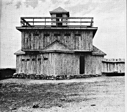
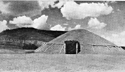
FORT ABRAHAM LINCOLN STATE PARK Above: Blockhouse of Fort McKeen
Below: Slant Indian Village Lodge
Photos by Russell Reid
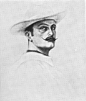
MARQUIS DE MORES (from an old drawing)
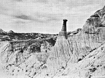
BADLANDS
Photo by Russell Reid
BELCOURT, 115.5 m. (1,619 alt., 6,334 pop., including Indian reservation), agency headquarters for the Turtle Mountain Indian Reservation, lies in a shallow valley on the southeastern border of the hills. It was named for the Rev. George Antoine Belcourt, a priest prominent in the establishment of the community. The Indians, about 95 percent of whom are of mixed Chippewa Indian and French blood, make their homes in crude cabins on small farms out in the reservation. Academic and vocational training for the children is provided by the large consolidated school in Belcourt. The Chippewa are woods Indians who when first encountered by the whites dwelt in the region of the Great Lakes. From here they pressed W., often warring with their enemies the Sioux, until ultimately their hunting grounds included the Turtle Mountain region. With the white occupation of the West their range in North Dakota was reduced until finally it was limited to this small and crowded reservation of 72 sq. m. (See Indians and Their Predecessors.)
Each year the Indians hold a sun dance (June; approx. 5 m. NE. of Belcourt; no set date or place). The ceremony lasts for several days. At the fairgrounds in Belcourt an Indian fair is conducted (Oct.).
Since 1896 the week of St. Ann has been the occasion of a retreat at Belcourt for the people of the mountains, for whom St. Ann is the patron saint. Many of the Indians bring their tipis in which they live during the retreat. The week is culminated with the feast of St. Ann (July 26, if it falls on Sun. or on Sun. following that date). On the feast day a procession is held, with hundreds participating. Many cures—none, however, authenticated by the Roman Catholic Church—have been attributed to the shrine at the Belcourt church.
DUNSEITH, 131 m. (1,715 alt., 484 pop.), scattered over level land at the edge of the Turtle Mountains, is the southern entrance to these hills. Its name means city of peace, and was selected to honor the first white man in the vicinity and also the city of Dunseith in Scotland. The town is the terminus of a G. N. Ry. branch from the main line at York (see Tour 6).
The Dunseith Gristmill was built on Willow Creek in 1887 of lumber hauled from Devils Lake by ox teams. It continued to grind for several years after steam boilers and modern machinery had come into general use, but in 1913 it was damaged by fire and has never been repaired.
Dunseith may have a buried treasure somewhere in the foothills. In 1893 its Turtle Mountain Bank was robbed, and the robber had time to bury his loot in the hills before he was shot by a posse. The stolen money was never found, and the bank was forced to close.
At Dunseith is the junction with ND 3, a graveled highway.
Right on this highway to the junction with a graveled road, 2 m.
Right on this road to SAN HAVEN, 0.5 m., State tuberculosis sanatorium, situated in a 2,500-acre game reserve on the southern slope of the mountains overlooking a vast expanse of prairie.
North from the junction with the graveled road, ND 3 runs over ridges and past little lakes, into the Turtle Mountains, whose hills are the habitat of hundreds of deer in addition to many varieties of song and game birds.
On ND 3 is the INTERNATIONAL PEACE GARDEN, 12.5 m., a memorial to the peace which has prevailed between this country and Canada for more than 120 years. The garden lies partly in North Dakota and partly in Manitoba. On the international boundary stands a stone cairn with a plaque bearing a pledge of peace:
"To God in His Glory We two Nations do pledge ourselves That so long as men shall live We will not take up arms against one another."
A formal garden, one mile square, is planned (1938) on the International Line. It will center about a peace fountain around which a circular garden plot will form a visible ring of friendship between the two nations. The memorial has attracted wide attention because of its noble purpose, and several foreign countries have expressed a desire to aid in its development. It is rededicated with appropriate ceremonies each year (1st wk. in Aug.).
To the S. and W. of the hills and also in the northeastern section of the State a great number of the settlers were of Scottish descent, and each year in connection with the ceremonies at the Peace Garden a Highlanders' Frolic is held with old-fashioned Scotch music, dances, and games.
West of Dunseith for 50 m. the route has not a single curve or jog.
At 138 m. is the junction with a partly improved dirt road.
Right on this attractive road to BUTTE ST. PAUL PARK, 3 m., plainly marked by Butte St. Paul (2,500 alt.), highest point on the southern edge of the Turtle Mountains. A steep climb up the eastern slope leads to the 15-foot stone cairn commemorating the work of the Rev. G. A. Belcourt, missionary to the Indians, who on his first visit in 1853 placed a wooden cross where the cairn now stands. From the top of the butte a beautiful scene stretches away to the tree-covered plateau on the N. and E. and to the prairies on the S. and W.
BOTTINEAU, 148.5 m. (1,645 alt., 1,332 pop.), was named for Pierre Bottineau (c. 1812-1895), most noted of Dakota guides (see History). It lies beside tree-bordered Oak Creek on a gently rolling plain. Most of its settlers were of Scottish descent, but the western end of the mountains was long nicknamed Little Norway, and until recent years Norwegian was heard there more often than English. From 1883-84 a stagecoach line connected the town with the nearest railroad point, Devils Lake (see Tour 6), 120 m. to the SE., whence settlers hauled supplies with oxen.
Originally Bottineau was situated a mile farther N. When the G. N. Ry. survey was made, it became evident that the permanent site would be farther S. Business houses were soon moved, but the Bottineau County Courthouse could not be legally moved without recourse to legislation. Accordingly, one morning the building was found reposing in the new settlement. As no one was supposed to know how the transfer had been effected, no one could be prosecuted, and the expense of returning the building to its former site provided a convenient and practical argument against that action.
A catastrophe long remembered by the early residents of Bottineau was a huge prairie fire in 1886 that swept 500 sq. m. of territory NW. of town, destroying hay and buildings.
The Indians of the region were not hostile to the white settlers, but there were Indian scares now and then, and the white men were inclined to be cautious. An old French settler living near Bottineau tells the story of being lost with two companions. They asked some Indians for directions, and were invited to a meal, which they accepted to avoid giving offense. They were almost enjoying the meal, when an old squaw, who had been stirring the stew which they had been eating, urged hospitably, "Dig down deep; pup in bottom."
The State School of Forestry, in the northeastern part of Bottineau on Oak Creek, offers a two-year junior college course in forestry. In the botanical garden or arboretum are about 30 varieties of foreign trees, obtained on a reciprocal basis from other countries, to be tried out in this climate. Plantings established under direction of the school are found on farms in every county in the State. The annual output of the nursery at the present time (1938) is about 500,000 seedlings.
At Bottineau is the junction with a graveled highway called the Lake Road, which leads NE. into the hills to Lake Metigoshe, one of the State's best-known summer resorts.
Right on this road, at the southern approach to the bridge over Oak Creek, to the junction with a trail, 1 m.
Left on this unusually delightful 5-mile trail, along the western bank of the creek. At about 0.5 m. is the junction with a less well-defined trail; L. here on the western side of the creek to a stone cairn marking the Site of the First White Man's Home in Bottineau County and the original site of the town of Bottineau, 1 m. Farther on the country becomes hilly, and at 2.3 m. a faint wagon trail leads R. through a wire gate down to the Gorge, a pleasant spot where the creek flows through a heavily wooded ravine, an excellent place for picnicking. Crossing the stream, the trail follows the eastern side of the creek back toward town. At 2.5 m. is the State Game Farm, temporarily (1938) used as the Bottineau Country Club; here is a junction with the Lake Road (L) which may be followed S.; along the side of the creek, a much more attractive route, at 4 m. the trail joins the Lake Road following the creek to the CCC Dam, 4.3 m., just N. of the Willow Vale Dairy Farm. Here the trail crosses to the western side of the stream and rejoins the trail on which it began.
Right on the Lake Road to the 640-acre LAKE METIGOSHE STATE PARK, 14.5 m. In the park lodge is the Henry Klebe Collection (open) of Turtle Mountain fossils, Indian artifacts, and geologic formations.
Left on the Lake Road 15 m. to the center of activity on LAKE METIGOSHE, largest and scenically one of the most attractive of the Turtle Mountain lakes. It has 70 m. of shore line and extends across the border into Canada. Its name comes from metigoshe washegum (Chippewa, clear water lake surrounded by oaks). There are six resort parks (stores, hotels, cottages, bathing beaches, boat landings; 12-mile motorboat trip crosses into Canada, not permissible to land on Canadian side). About 1 m. from shore is Masons' Island, where Masonic groups hold annual summer meetings. The Congregational Conference of North Dakota has a summer Bible camp on the lake, and the Great Plains Area of the Boy Scouts of America holds an annual encampment here.
West of Bottineau the route proceeds over the extraordinarily level country formed by the bed of glacial Lake Souris. At 156.5 m. is the junction with ND 14, a graveled highway.
Left on this highway is KRAMER, 9 m. (1,460 alt., 190 pop.), believed to have been named for one of the surveyors of the Soo Ry., which passes through the town. The Kramer Equity Cooperative Elevator, with a capacity of 110,000 bu., all under one roof, is one of the largest cooperative elevators in the State.
Right from Kramer 2 m. on an improved county highway to a junction with a road; L. on this road to the junction with another road, 3 m.; R. here to a permanent CCC CAMP, 4 m., whose workers construct dams on the Souris River and work on the LOWER SOURIS MIGRATORY WATERFOWL REFUGE, an area of 48,000 acres, largest project of the U. S. Biological Survey in North Dakota (1938).
At 13 m. on ND 14 the route crosses the Mouse or Souris River, remnant of Lake Souris. At 14.5 m. are the headquarters of the refuge, where the Administration Buildings are. The 100-foot observation tower is used in studying bird life (open, children must be accompanied by adults).
UPHAM, 18 m. (1,461 alt., 257 pop.), is believed to have been named by the G. N. Ry. town site company. Left from Upham at 22 m. on an improved county road to the largest dam being constructed on the lower Souris Refuge, a retaining dike approximately 3 m. long.
At 165.5 m. the highway dips slightly and crosses the Souris River, here resembling a canal, and running almost bank full. At 175 m. is a junction with US 83; between this point and 192 m. the two roads coincide (see Tour 3).
MOHALL, 202 m. (1,646 alt., 676 pop.), seat of Renville County, was named for M. O. Hall, publisher of the first newspaper. Platted in 1903 as the terminus of the railroad, its growth for the first few months was rapid. The Renville County Tribune of December 3 of that year said that the G. N. Ry. agent estimated that during the preceding week 125 carloads of material had been shipped into the new town, in addition to 175 cars lying on sidetracks along the line and billed for Mohall. Four tracks were crowded with cars and eight dray lines were kept busy transferring the material to the lumberyards and points of construction. One hundred and seventy-five carpenters were employed, and then the demand was only half met. At that time the place had nine grain buyers.
Dick Grace, motion picture stunt flier, lived here for a time.
A CCC CAMP with an enrollment of about 200 adjoins the town. At present (1938) its members are assigned to work on the Upper Souris Migratory Waterfowl Refuge (see Tour 7).
At 205 m. the route passes between two farms lighted by natural gas from wells drilled on the premises. Although natural gas in large quantities has been found in Montana, and a number of small wells have been opened in North Dakota, there has never been a sufficient amount in this State to form the basis for a permanent commercial enterprise.
At 214 m. the route leads down into the mile-wide Souris valley. The stream here is lined with box elder, elm, and small fruit trees.
At 215 m. is the junction with a graveled county road.
Right on this road to the 480-acre MOUSE RIVER PARK (boating, swimming, roller skating, golf; store, dining hall, auditorium, cottages), 2 m.
At 229.5 m. is a junction with US 52, a graveled highway, which unites with ND 5 between this point and 257 m. (see Tour 7).
At 258 m. is the junction with a graveled county highway.
Left on this road is LIGNITE, 1 m. (1,979 alt., 217 pop.), which was to have been named Kincaid, for an agent of the G. N. Ry., but through an error of the town site company was given the name intended for the neighboring town, a lignite mining center, which was consequently named Kincaid.
At 8 m. BIG BUTTE (2,200 alt.), a large grassy hill, covers about two sections of land, rising more than 200 ft. above the surrounding prairie. At the foot of the butte was once a spring of excellent water, frequented by Indians passing along the old White Earth Trail from the Turtle Mountains to the Missouri River. Circles of stone and Indian mounds are found on the northern side of the butte. In early days there was a ranch with 300 head of horses near the spring, but the owner lost all his stock to smugglers. Somewhere in the vicinity of Big Butte may be the hiding place of $40,000. A story, not generally credited, relates that in the late 1870's a Hudson's Bay Co. paymaster, on his way to pay employees of the company at the several trading posts in the territory, was robbed of this amount near Estevan, Canada. The robber was apprehended in the neighborhood of Big Butte, but not before he had found a place to cache his loot. Taken to Portal, he died under torture while an attempt was being made to force his secret from him. On the tanned side of his fur coat was found a diagram believed to show the hiding place of the treasure, which has since been the object of many searches. The accidental unearthing of a stone bearing the inscription "1877" inspired fresh digging. At another time the Royal Mounted Police of Calgary are said to have sent men to the locality in an attempt to recover the money. So far, however, all efforts have proved unsuccessful. Some believe the treasure was found and taken away; others think it is still in the vicinity of Big Butte; and a few skeptics disdain the idea that it was ever buried here at all.
At 268.5 m. is the junction with a graveled road.
Right on this road is COLUMBUS, 0.5 m. (1,930 alt., 516 pop.), clumped together on the flat prairie. First settled in 1902, it was moved to the railroad in 1906 when the Soo Ry. was extended through this part of the State. The first postmaster, Columbus Larson, gave his Christian name to this town, and his surname to the next town W.
At 269.5 m. is a junction with ND 40, a graveled highway.
Left on this highway 3 m. to a junction with an improved road; R. here to the MONTANA-DAKOTA POWER PLANT, 2 m., in the heart of the lignite coal field. The plant was opened 1928, and today is a $300,000 enterprise, supplying electrical energy to the towns of northeastern Montana and northwestern North Dakota.
At 4 m. on ND 40 is a junction with a second improved road; L. here to the TRUAX-TRAER LIGNITE STRIP MINE, 4.5 m., the oldest strip mine in North Dakota. The big shovels which have been stripping the earth overburden since 1919 have piled ridges of earth so vast that they resemble miniature mountains. The eight-cubic-yard shovel saw service in the construction of the Panama Canal. It is supplemented by another of four-cubic-yard capacity. About 150,000 tons of coal are taken out annually. Huddled on a small piece of unbroken ground between the artificial buttes are the frame homes and store buildings of the little community of miners.
At 273 m. is the junction with a graveled spur.
Left on this road is LARSON, 0.5 m. (1,931 alt., 89 pop.), a small Scandinavian town, named for the first postmaster of Columbus.
West of Larson the route ascends the hills of the Missouri Plateau. At 278 m. is the junction with a graveled road.
Left on this road to the BAUKOL-NOONAN COAL MINE, 1 m., third largest lignite strip mine in the State. The mining operations cover an area of 1,040 acres adjacent to the town of Noonan, and the lignite vein, which lies beneath a 30-foot overburden, averages 7 to 9 ft. in thickness. The huge, molehill-like hummocks of earth tossed up by the giant steam shovels spread fanwise from a central, electrically operated tipple. Loading and screening facilities at the tipple permit the filling of four cars at the same time, each with a different grade of coal. The daily output of the mine, which runs full time during the fall and winter months, is approximately 100 cars. During the 1935-36 season more than 170,000 tons of coal were taken out.
NOONAN, 279 m. (1,959 alt., 423 pop.), named for an early settler, has its white buildings scattered over the northern slope of a small hill. When the town was platted in 1906, contracts stipulated that buildings should be painted white in order that the community might live up to its advertised name of the White City.
CROSBY, 292.5 m. (1,962 alt., 1,271 pop.), dominated by the dome of the Divide County Courthouse at the northern end of Main St., was named for a member of the town site company of Portal (see Tour 7). It sprang up at the junction of the Soo and G. N. branch lines, a strategic rail position that soon established it as a focal point for trade in the northwestern corner of the State.
Straight ahead (N) from the fairgrounds on a graveled road to the CROSBY CITY RECREATION PARK (swimming pool, golf course, tennis and horseshoe courts, ski jump, camping ground), 5 m., developed along the Canadian border.
At 301.5 m. is a junction with US 85 (see Tour 4), which unites with ND 5 to 311 m.
FORTUNA, 315 m. (2,190 alt., 196 pop.), a Scandinavian community, named for the Roman goddess of fortune, was established in the summer of 1913 when the branch line of the Soo Ry. was extended from Ambrose, N. Dak., to Whitetail, Mont. The day lots were sold, temporary business houses, which had been squatting a mile from the present site at a post office called Norge, were put on wheels and rolled away to the new town by night.
Right from Fortuna on a county road to the DEWITT SPRING, 1 m., whose flow fills a two-inch pipe of water the year around. It has furnished water for Fortuna since the founding of the village.
At 329 m. the route crosses the Montana Line, 66 m. E. of Scobey, Mont.
SIDE TOUR 5A
Junction ND 5—Walhalla—Leroy. ND 32, ND 55, and an unimproved road.
Junction ND 5 to Leroy, 25 m.
Branch of G. N. Ry. touches at Walhalla.
Graveled roadbed except for 0.5 m. outside Leroy.
Accommodations in Walhalla.
This route runs through the Pembina Mountains, a scenic region rich in historical associations. From Walhalla, one of the oldest towns in the State, the route turns east to the settlement of the metis, descendants of those French-Chippewa who conducted the famous Pembina hunts of the middle nineteenth century.
ND 32 branches N. from ND 5 at Oak Lawn Historic Site (see Tour 5), 0.0 m.
At 8 m. the graceful wooded PEMBINA MOUNTAINS are visible on the horizon. The nearest elevation, 250 or 350 ft. higher than the country to the E., is known as Second Pembina Mountain, and is a portion of the Pembina Escarpment, a high ridge extending from Canada through North Dakota into South Dakota and southwestern Minnesota. In the southern part of North Dakota it is known as the Coteau des Prairies. First Pembina Mountain, lying SE. of Second Mountain, is the prehistoric delta of the Pembina River, formed when that stream drained the melting ice sheet into Lake Agassiz (see Natural Setting and Tour 1). First Pembina Mountain has an average height of 150 ft., and its eastern edge shows the various shore lines of Lake Agassiz as it receded in post-glacial times.
To the first white explorers and trappers the Pembina Mountains were known as the Hair Hills, coveted hunting ground held by the Chippewa, whose ownership was often hotly contested by the Sioux. During the early nineteenth century white and half-breed hunters roamed the hills, gathering furs to be loaded on lumbering, squeaking oxcarts and sent to eastern trading posts.
It was in this vicinity that Charles Cavileer (see Tour 5), one of the most prominent settlers of the State, in the 1860's while making a trip with a party from Pembina to Devils Lake, saw a herd of buffalo like a black cloud on the horizon. The party immediately arranged their carts in a semicircle and prepared for an onslaught. The bison came on with a rumble like thunder, the rumble became a roar, and the earth trembled; but when they reached the carts the herd parted and swerved on either side, upsetting only the outside row of the improvised stockade. Not until the second day could the journey be resumed, and even then there were buffalo in sight for another day. The herd was believed to number two or three million, and in its wake was an area, several miles in width, entirely devoid of vegetation.
At 9 m. (L) are the SAND SLIDES, where steep sand and gravel slopes form a precipitous funnel-shaped valley down to the PEMBINA RIVER. This stream once drained prehistoric Lake Souris into Lake Agassiz, and its rushing waters cut into the Pembina Mountains, creating the present canyon 350 to 450 ft. deep.
At 12 m. (R) is WALHALLA (966 alt., 700 pop.), attractively situated in the wooded river valley on the slope of Second Pembina Mountain. In 1848 Father G. A. Belcourt established St. Joseph's Mission here for the Chippewa Indians. By 1860 the settlement had become an important fur trading post, with a population of 1,800; but good furs became scarce, the bison virtually disappeared, and by 1871 "St. Joe" was inhabited only by a priest, the U. S. customs inspector, and some 50 metis or half-breeds, who remained only as long as the hunting was good. The town revived, and was platted in 1877 and renamed Walhalla, for the palace of immortality in Norse mythology.
The old bell in the Catholic church belfry, known as the Angelus Bell, was brought to Father Belcourt's mission when it was opened, and was the first church bell erected on the plains of North Dakota. It was cast in 1845, and a wreath of raised figures around the top represents science, art, music, mechanics, and astronomy. The bell is believed to have been brought down the Red River by boat, thence to St. Joseph by oxcart. Its tone is similar to that of the old mission bells of California.
Right from Walhalla crossing the railroad tracks on a graveled road; L. on a graveled road to a METIS SETTLEMENT, 4 m. Here, in the foothills of the Pembina Mountains, live descendants of half-breed French Canadians and Indians of earlier days. The metis are found throughout the northeastern corner of North Dakota (see below). In this particular settlement they operate small farms, gaining their livelihood by selling garden produce, berries, and cordwood. The graveled road turns L. at 5 m., to Leroy (see below), 7 m.
Also at 12 m. is WALHALLA STATE PARK (L), on the eastern slope of the Pembina Mountains. The wooded 5-acre tract contains the Site of Alexander Henry, Jr.'s Trading Post, a temporary depot established in 1801, one of the first posts in present North Dakota; also the Kittson House, erected in 1851-52 as a trading post and warehouse under the supervision of Norman Kittson, who became the first postmaster in North Dakota. This building was originally built nearby and was moved to the park in 1915. Often locally designated as Old Settlers' Park, the area is the scene of the annual meeting and picnic of the Pembina County Old Settlers' Association (July).
Left from the park on a winding graveled road to the PROTESTANT CEMETERY, 0.4 m., where are buried two missionaries killed by Indians in the early 1850's and hence known as the Martyrs of St. Joe. At 1.4 m., at the summit of the mountain, LOOKOUT POINT affords a fine view of the deep Pembina River valley below and the Red River Valley farming area, dotted with villages and farmhouses, which stretches away in the distance. The point is the property of several Masonic lodges in this area, and they hold an annual picnic here.
At 15 m. on ND 32 is the junction with ND 55, on which the route continues. At 22 m. is the junction with a graveled road. After crossing the Pembina River, the highway at 25 m. enters LEROY (890 alt., 100 pop.). The inhabitants of the town are chiefly metis and their log cabins are scattered in the timber along the river. From the time the Hudson's Bay Co. began operations in 1670, French Canadians migrated westward, intermarrying with Chippewa women. Their children were known as metis or mixed-bloods. Inheriting the characteristics of both the Indian and the French-Canadian woodsman, the metis became adept voyageurs, and their part in the early fur trade of the Middlewest was very important. They were excellent hunters, trappers, and couriers, and it is said they loved the "musical" sound of the Red River oxcarts which, with their unlubricated wooden axles and hubs screeching across the plains, brought furs E. from the trading posts.
When this region began to be settled the metis were the first mail carriers, since their stamina and knowledge of the frontier made them "brave and bold, and the most reliable men to be had."
The early metis of North Dakota, ancestors of the present metis, enjoyed life with true appreciation. They were fond of good dress, and their clothes were made of the finest imported merinos, cashmeres, and broadcloths, bought at the trading posts. The men wore black broadcloth redingotes, long and double-breasted and trimmed with large brass buttons. At the collar was a capuchon or hood, which was never worn but served merely as an adornment. A bright sash about the waist, beaded moccasins, and a beaded tobacco pouch, used much as a French courtier used his snuff box, completed the costume. The women wore the tight basque and flowing skirt, and, in summer as well as winter, a half dozen gaily colored petticoats, which created quite a dazzling array when the wearer stooped to tie the lace of a beaded moccasin. A black silk kerchief was tied about the head, and over this went a large square of black broadcloth which wrapped about the entire body and served as a cloak.
The metis were, and still are, fond of music and dancing. Their songs came down from their French ancestors or were learned from the mission priests. One favorite was Au clair de la lune (By Moonlight) and another was Marlbrouck s'en va-t-en guerre (Marlborough Goes to War). Square dances, the Red River Jig, Pair O' Fours, and Reel O' Cats were favorite dances, and some of them are still performed.
The most important event in the year for the metis, in the first half of the last century, was the Pembina buffalo hunt. For this, white and metis hunters would meet at Pembina on an expedition which sometimes took them as far as Fort Union on the Missouri (see Side Tour 6B). Not only men, but also women and children, went on the hunt, and even the priest went along to counsel and advise. Equipment was carried in stridently creaking oxcarts. It was like a good-sized town on a tour. On the hunt of 1840, probably the largest ever held, there were 1,630 people and 1,210 oxcarts, and the cost of the expedition has been estimated at $120,000. The camp was organized under a chief, with 10 captains under him, and 10 soldiers under each captain to enforce the camp regulations. For a first violation the saddle and bridle of the offender were cut up; for a second, his coat was destroyed; and for a third, he was flogged. A thief, even if he stole something of no greater value than a buffalo sinew—a common article of barter in the Red River country—was publicly cried "thief." Hunting was not always good; hot weather or storms delayed parties, and sometimes prairie fires were encountered. Eventually encroaching civilization put an end to the buffalo hunts, but while they were held, and when they were successful, the hunters lived in plenty. The 1840 expedition took home more than a million pounds of meat in their oxcarts.
The main food of the early metis was pemmican, or dried buffalo meat, but wild game was also plentiful. Galette, an unleavened bread made by mixing flour with water, salt, and shortening, was preferred to white man's bread.
Great respect for old age, and deep affection for relatives characterize metis family relationships. Concerning birds and animals, they have many unusual beliefs: a hungry beast coming to the door is regarded as a sign of poverty, a woodpecker pecking at a window is said to be a sign of death in the family, and snakes are believed to be symbols of quarrels and enemies.
TOUR 6
(Duluth, Minn.)—Grand Forks—Devils Lake—Minot—Williston—(Glasgow, Mont.). US 2.
Minnesota Line to Montana Line, 390.5 m.
G. N. Ry. roughly parallels entire route, Farmers' Line between Devils Lake and Webster.
Graveled roadbed except for about 110 m. of short stretches hard-surfaced.
Accommodations in principal towns.
This route reveals a cross section of the agricultural life of the State. In the east the flat, fertile lands of the narrow Red River Valley, which formed the bottom of glacial Lake Agassiz, blend into the uneven, farm-dotted surface of the broad Drift Prairie, bordered on the west by the rougher, more sparsely settled grazing areas of the Missouri Plateau. The route touches on Devils Lake and crosses the level loop of the wooded Mouse River, a region at one time covered by Lake Souris, another extinct creation of the glacial epoch. Midway across the State is the geographic center of North America. The western half of the route is through a rich, though largely undeveloped, lignite coal area, formed ages ago by the inundation of prehistoric forests.
GRAND FORKS, 0.0 m. (834 alt., 17,112 pop.) (see Grand Forks).
Points of Interest: University of North Dakota, Wesley College.
At Demers Ave. and 5th St. is a junction with US 81 (see Tour 1), which unites with US 2 to the intersection of Skidmore Ave. N. and N. 16th St.
West of Grand Forks US 2 passes through the western half of the Red River Valley, part of the bed of ancient Lake Agassiz.
At 9 m. is the junction with a county dirt road.
Left on this road to tiny OJATA, 1 m., the remains of a once thriving boom town known as Stickney. In its heyday it was a railroad terminus, and for a time rivaled Grand Forks in trade. Since the site is swampland, each heavy rain makes it a quagmire, and residents, considering the first name too literal, soon changed it to Ojata. The place declined when the railroad was extended W. At one time a farmer acquired the entire village in exchange for a stallion.
At 20 m. is the junction with a county graveled road.
Right on this road to TURTLE RIVER STATE PARK (swimming, picnicking, camping), 3 m., where a picturesque ravine, cut by the once swift-flowing waters of the TURTLE RIVER, offers a pleasing variation to the level surrounding country. The river is named for the many small terrapin found on its banks. Just W. of the entrance are 15 tumuli (mounds) built by prehistoric Indians. Excavations by Dr. A. E. Jenks of the University of Minnesota have yielded copper instruments, an ivory pipe, and other artifacts. Unlike the mounds in other parts of the State (see Side Tours 8A and 8B), these have been plowed over and cultivated until they are only small humps on the prairie. The few tumuli opened have been easily excavated because they lie in a gravel deposit.
ARVILLA, 21.5 m. (1,019 alt., 150 pop.), was named for the wife of a bonanza farmer. The Grand Forks County Farm and Hospital, a large brick structure, is situated just across the railroad track on a 136-acre tract adjoining the town on the S. The Arvilla Academy and North Dakota Conservatory of Music, the first private college in the State to maintain a music department, was founded in 1886 by Rev. John Allen Brown, Presbyterian pastor at Arvilla. Miss Sadie P. Brown, daughter of the founder, and a graduate of the Boston Conservatory of Music, headed the music department. The existence of the academy was brief, for the building was destroyed by fire in 1893 and was never rebuilt.
The CRYSTAL SPRINGS STOCK FARM, 23.5 m., consisting of 2,480 acres along the Turtle River, was a bonanza farm and then a stock farm, but now is known for the spring water bottled here for commercial purposes. In its early days the 20-room house, now standing empty with its venetian shutters flapping in the wind, was the scene of a social life that rivaled the surrounding bonanza acres in expansiveness and amplitude. H. T. Hersey, a Minnesota millionaire, became interested in wheat farming and built the house. His wife installed a full staff of servants, and many parties were held for eastern friends. On several occasions James J. Hill stopped his special train here to visit the Herseys, and once a special train carrying members of the State legislature stopped while its passengers were entertained at this prairie palace. Eventually Hersey tired of his role of gentleman farmer and sold his farm to James Streeter, prominent Larimore real estate dealer and farmer.
LARIMORE, 28 m. (1,135 alt., 979 pop.), was named for N. D. Larimore, stockholder and business head of the Elk River Valley Farm, which was once the world's largest farm under single management. Most of the bonanza farms were divided into a number of tracts, each under a foreman, but the Elk River Valley Farm had all operations centralized. Its huge proportions attracted the St. Louis World's Fair Foreign Commission, which visited the farm in 1904, at which time there were 11,000 acres under cultivation. From this visit a great influx of northern Europeans resulted, leading to the breaking up of the bonanza farms and the sale of small farms to the new settlers.
The City Park (wading pool, tennis courts, tourist camp) is in the same block as the city hall.
At 32.5 m. the highway crosses the Turtle River, near a dam built by the Civilian Conservation Corps (swimming, picnic grounds).
McCANNA, 38 m. (1,142 alt., 100 pop.), was named for S. A. McCanna, owner of the McCanna Farm (R), now the largest in the western part of Grand Forks County. Large modern buildings adjacent to the town on the NW., and the use of modern farm methods make it one of the show places in the area.
NIAGARA, 44.5 m. (1,443 alt., 207 pop.), was named for Niagara County, N. Y. Because of uncertainty as to where the railroad would pass, the town was first built on skids 1 m. E. of the present site, and was moved when the railroad came in 1882.
PETERSBURG, 51.5 m. (1,524 alt., 310 pop.), named for a pioneer clergyman in the community, has a population predominantly Norwegian, as has MICHIGAN CITY, 57.5 m. (1,520 alt., 433 pop.), platted on land of the James Lamb family, who were among early arrivals in the vicinity and have continued to be prominent in local affairs. The town was named in honor of the native State of many of its first settlers. In the early 1880's an error in billing sent here an entire trainload of iron ore intended for Michigan City, Ind. The village officially retains its original name, but local usage has abridged this to "Michigan."
MAPES, 62.5 m. (1,530 alt., 56 pop.), once a prosperous grain shipping center, was named for Emery Mapes, one of the men who worked out the formula for the nationally known Cream of Wheat.
At 67.5 m. is the junction with ND 1, a graveled highway (see Side Tour 8B).
LAKOTA, 68.5 m. (1,518 alt., 860 pop.), is the seat of Nelson County. Its name is derived from the Teton Sioux word meaning allies, which is the same as the Santee Sioux dakota. The many trees lining Lakota's streets are the result of experiments by a pioneer who believed trees could be grown on the barren prairies. The Tofthagen Library and Museum (open), built in 1927, was a gift to the city from A. M. Tofthagen, Nelson County pioneer. It contains 5,000 volumes, and curios gathered by the donor in his travels.
BARTLETT, 72.5 m. (1,534 alt., 67 pop.), was named for Frank Bartlett of Larimore, who owned the town site. For a time Bartlett was the end of the rail line, a typical boom town, and had 21 saloons; one, the Diamond, employed a Negro piano player and singer who usually ended his performance in a burst of "Bartlett, dear Bartlett, will be a dandy of Dakota yet."
DOYON, 78.5 m. (1,512 alt., 204 pop.), was named for Charles H. Doyon, a bonanza farmer.
DEVILS LAKE, 96 m. (1,466 alt., 5,451 pop.), seat of Ramsey County, was at one time head of steamboat navigation on the then important inland sea of Devils Lake (see Side Tour 6A). The lake has receded 5 m. in the half century since the vicinity was settled, and the town now overlooks a dry bed and shrunken shore line. Fort Totten, which later became Fort Totten Indian Agency (see Side Tour 6A), was established on the southern shore of the lake in 1867 to place the Indians of the region on a permanent reservation. In 1882 the Government held that the Chippewa Indians had no claim to the lands N. of the lake, settlers began to come in, and Creelsburgh, or Creel City, 4 m. NW. of the present site of Devils Lake, became the first white community in the area. The town of Devils Lake was founded the following year and many Creel City citizens moved to the new town site.
One of the first settlers in Creel City was Capt. Edward Heerman, who inaugurated steamboat navigation on Devils Lake. On July 4, 1883, the first train on regular schedule arrived in Devils Lake, and was met by Heerman's steamboat, the Minnie H. The service was later augmented by two smaller steamers. Rails were laid on the wharf at Devils Lake so that all freight and passengers for Fort Totten, Minnewaukan, and other points across the lake were transferred directly from car to steamer. By 1909, however, the water of the lake had receded 4 m. from the city, 6 m. from Minnewaukan, and nearly 2.5 m. from the fort, so navigation came to an end. The shrinking of Devils Lake has been one of the arguments for the Missouri River Diversion project, which, it has been asserted, would raise the water level of the lake.
The State School for Deaf is at 14th St. and 1st Ave., situated in expertly landscaped grounds. Established in 1890, the school has gained international recognition for its work in physical education for the deaf. An elaborate revue, known as a Rhythm Pageant (public, June), is presented annually at the school's graduation exercises, and motion pictures of this pageant have been made for study in similar institutions elsewhere.
At the eastern end of 2nd St. is the I. O. O. F. HOME, maintained by the North Dakota Grand Lodge of the Odd Fellows for its aged members and orphans of former members. It is a three-story brick building surrounded by landscaped yard and gardens.
The World War Memorial Building, 504 4th St., is a community recreation center. Studios and transmitter of KDLR are in the Grayson Hotel building at the cor. 5th Ave. and 7th St.
At the W. end of 5th St. is the junction of ND 20, a graveled highway (see Side Tour 6A) and ND 19. Right at this junction is Roosevelt Park (swimming pool, picnicking, camping), built as a WPA project.
North of Devils Lake US 2 passes SWEETWATER LAKE, 105 m., once a large body of fresh water that attracted pioneers. Today, like that of Devils Lake, its shore line has greatly receded.
CHURCHS FERRY, 123 m. (1,460 alt., 295 pop.), developed from a ferry established by Irvine Church across Mauvaise Coulee (Fr., bad streambed) in 1886, so named by French explorers because it was difficult to cross, the channel once drained a large territory into Devils Lake to the S. Although it has been dry for several years, in the 1870's and 1880's, until Church began his ferry, all goods for the area NW. and W. of Devils Lake had to be boated across or hauled around the southern shore of the lake.
At 124 m. is the junction with US 281, a graveled highway (see Tour 2), which unites with US 2 from this point to 131 m.