THE ANCIENT AND MODERN TRENT By Bernard Smith, M.A.
Reading edition
The River Trent
The valley of the Trent deserves to be considered as one of the most interesting of the antiquities of the county of Nottinghamshire. When our ancestors dubbed it “The broad vale of Trent,” they unconsciously laid stress upon its width, and, in fact, rightly, because the present river Trent is a misfit—too small for the valley—a shrunken representative of that ancient stream which carved the great steep-sided trench between Nottingham and Newark.
There is something very human about the behaviour of rivers; they live and move. In their youth, and at their headwaters, they are full of energy, constantly overcoming difficulties and removing obstacles from their course. As mature streams their paths are smoother and their ways more orderly. In old age they wander lazily to the sea, often haltingly and dropping their burdens on the way. But—unlike human beings—they are constantly at work. Should their energy be greater than is required to carry their load of rock-waste, they employ it in lowering and widening their beds, and in clearing and straightening their path to the sea. If all their energy is required to carry their load they can still burrow sideways into their banks, although they cannot now cut downwards. If the load is too great they wisely drop the overburden and carry that which their strength is equal to. The power of a river should never be gauged by its work or appearance at ordinary times, for tremendous vigour—out of all proportion—comes both with increase in volume and increase in pace, conditions only fulfilled when the river is in flood. Rivers, again, are more than human in the manner in which they adapt themselves to their environment. If hard rocks must be crossed they take the shortest path in a narrow gorge; if soft rocks are traversed they follow them as long as possible, meandering somewhat lazily along the path of least resistance; they thus tend to become adjusted to the texture and grain of the rocks over which they flow.
The Ancient Trent
The history of the river Trent is intimately connected with the story of the Great Ice Age in Britain. This event—so recent from a geological standpoint—was fairly distant from the human point of view, since nearly all of the Palæolithic relics of this country date from the retreat of the ice.
Long before the Ice Age (at a time when great earth movements were taking place upon the Continent and building up the Alps) the younger rocks in the Nottinghamshire area were uplifted and tilted gently to the east, away from the older and underlying Carboniferous rocks of the Pennines, and were thus brought within the influence of destructive processes.
Rivers, running down the slope in the direction of the North Sea, began to cut deeply and form a plain, whose general surface agreed roughly with the slope of the river channels. The higher beds on the west were stripped away, because a river is more active and cuts more deeply at its head than near its mouth. Hence the original surface of the uplifted plain has gone; the new surface slopes on the whole from west to east, and the older rocks are more elevated than the younger ones.
Tributary streams, developed along north and south lines in the soft belts of rock, became in time more important than the first-formed west to east streams. One of these tributaries, no doubt, working its headwaters backwards from the Humber, formed a valley in the red clays of Nottinghamshire which lie west of the Lincoln Cliff, and tapped the easterly-flowing waters, thus forming a river very similar in direction to the present Trent.
However this may be,[41] there is no sign of that river and that valley at the present day, although they were doubtless the guiding lines which eventually determined the course of the Vale.
Nottinghamshire was invaded by ice-sheets descending from the north. The direction of movement was rather from the west of north in the west of the county, and from the east of north in the south-east of the county; and as the ice advanced the rivers were naturally destroyed, partly by refrigeration, but chiefly by being invaded by ice. When the climate ameliorated the floods were let loose and the waters sought their old channels.
As the ice-front retreated it left behind it a mass of gravel which was in part washed from the ice-front by water draining the ice, and in part introduced by floods from distant sources. At the same time it is possible that much of the gravel was deposited beneath the surface of a large sheet of water; for in late-glacial times the water in this district seems to have been augmented by floods pouring into the basin from the direction of the Cheshire Plain and endeavouring to escape to the North Sea, since its escape to the Irish Sea was prevented by the Irish Sea ice. In our district it is thought that the water, finding its passage to the Humber barred by the retreating extremity of the ice-sheet, which rested against the cliff north of Lincoln and extended thence to the high ground north-west of Kelham, was forced to pour over a low gap in the hills at Lincoln.
The highest elevations between Newark and Lincoln, near Coddington, Potter’s Hill, Swinderby, Eagle, and Doddington, are capped by the gravels of late-glacial age. The Lincoln gap was then cut down; the ice had now probably retreated—although there is no direct evidence—and already opened up the way to the Humber, and a second series of gravels distributed by running waters on gently-inclined slopes of the solid formations and in hollows scoured through the older gravels. Such gravels occur near Nottingham, Radcliffe, Farndon, and Newark; and from the latter place they stretch to Winthorpe and Langford, and thence in a well-defined S-shaped belt to within one and a half miles of Lincoln. They are also found to the east of that city. The waters were again rapidly lowered and escaped by two exits—the Humber and the Lincoln Gap. Gravels formed at this stage occupy not only the floor of the present Trent valley, but below Newark spread widely over the ground to the east, abut against the well-marked terrace of the second series near Langford and Eagle, and sweep round the northern flank of the Doddington Hills to Lincoln.
The rather scanty evidence at our disposal tends to show that all these deposits were formed after the retreat of the ice, for although they rest upon boulder-clay (the ground moraine of the ice-sheet) at several points, they are never found beneath it. Between Nottingham and Newark the valley floor is almost certainly post-glacial, for, were it not so, we should expect to find boulder-clay on the valley slopes or beneath the river deposits—but such relics are wanting. The river had, however, established its present course very soon after the close of the Ice Age, because the bones of extinct mammalia—mammoth, rhinoceros, and hippopotamus—have been found in the valley deposits above Nottingham. At such a time heavy floods would occur when the winter snowfall melted in the spring, and the river and its feeders would be larger and more powerful than the present stream, which cannot lift and spread gravel over its flood plain.
Between the flood-periods the stream was choked with débris and gravel-bars, and compelled to split up into rapidly changing branches which spread the gravels far and wide. Such was the ancient Trent—a powerful flood immediately after the Ice Age, but slowly dwindling in volume and power as, in course of time, it cut deeper and deeper and sunk its valley below the level of the earlier-formed gravels, which were therefore left as terraces and flats above the level of the latest and lowest flood-plains (Fig. 1). The older gravels are probably of Palæolithic Age, although no remains of the earlier Stone Age have been found in them. Palæolithic man, however, inhabited the district, for signs of his presence have been discovered in the Creswell Caves, hence it is reasonable to expect that Palæolithic implements may eventually be discovered in some of the oldest post-glacial gravels between Nottingham, Newark, and Lincoln.
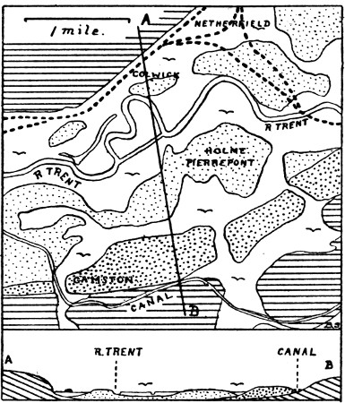
Fig. 1.
In the Idle and Leen valleys there are also gravel terraces of considerable antiquity, whose history is very similar, although somewhat shorter than those of the Trent.
The Present River Trent
Since the accumulation of the river gravels there has been slight widening of the valley in places, but hardly any deepening. The gravels, as a rule, are spread over it from side to side beneath the recent alluvium of the present enfeebled river, and the surface of the alluvial plain is at a slightly lower level than that of the gravel terraces. At ordinary times the river meanders to and fro among its ancient gravel-bars without sufficient energy to clear away all the detritus brought down to the flat by its tributaries. It rearranges the mixed sandy gravel of the old river, depositing the sand above the gravel, and placing a layer of loam, derived mainly from red Triassic rocks, upon the top of all. Thus the alluvial plain—within the old gravel plain—is built up both by lateral wandering of the river and by the floods which level up the surface.
Between Midsummer and Christmas A.D. 1346 long continued rains caused one of the most disastrous of the early recorded floods. In 1683 the bridges at Nottingham and Newark were destroyed by ice and water, due to the breaking up of a frost (which began in September, accompanied by much snow). Muskham and Holme also suffered severely. The Brampton bank (Breach Pit Bank) was broken five times previous to 1730, and again in 1824, since when a new bank has been erected. The banks near Newton and Torksey gave way in November 1770 and flooded all the lands on both sides of the Foss Dyke as far as Lincoln, flooding villages and destroying great quantities of hay and corn. Water stood several feet deep in the houses of Narrow Marsh, Nottingham. Floods also occurred in 1774 and 1790.
The great flood of Candlemas 1795 was—like that of 1683—the result of a quick thaw after a frost, which lasted from December 24, 1794, until February 9, 1795, and was accompanied by some 15 inches of snow. In Notts, as well as in Staffordshire and Derbyshire, the whole of the Trent valley was a scene of desolation, rendered more terrible by the masses of ice and melted snow carried along by the waters. The outer river bank near Spalford (the Wath Bank) burst at the south-east end of South Clifton Hill (Fig. 2), where the signs of the flood are still discernible (the hollow formed, though now dry, was long filled with water). An immense breach was formed, into which 80 loads of faggots and over 400 tons of earth were dumped before it was filled up.
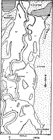
Fig. 2.
Sweeping across country from this gap, the water soon converted some 20,000 acres of land, west of Lincoln, into a vast lake, and only stopped here because the High Street at Lincoln was raised above the general level of the Foss Dyke. The country inundated being in those days largely composed of swamp lands (now drained and cultivated), the damage would bear no comparison to that which would be caused by a similar flood at the present day.
With one exception it entered every house in Spalford, and Girton village street was submerged 3 feet. The water rose to a height of 4 feet 6 inches on North Collingham Churchyard wall (31 feet 6 inches above O.D.). In Nottingham the inhabitants of Narrow Marsh were prisoners for two days and nights, the water being 3 feet deep in some places. Water also entered these houses in 1809.
A great inundation took place in 1814 after snow and frost, and thousands of acres of hay and corn were laid under water by a high flood on the 5th August 1839; whilst in November 1852, before the bank gave way near Dunham, the waters were halfway up the western wall of Collingham Churchyard and drowned Girton village street to a depth of 2 feet. At Nottingham the waters rose 14 feet 9 inches above their mean level.
In more recent times a sudden thaw produced an immense flood in January 1867, and in October 1875 thousands of acres were deluged in the Trent valley, the scene from Nottingham or Newark Castles being most remarkable, buildings, hedges, and railway lines alone appearing above the water-line. Marks registering this flood are preserved at Nottingham, Fiskerton (Trent House), Newark, Collingham, Girton,[42] and Low Marnham (the stone crosses at North Muskham and Holme are said to be records of floods, but are unfortunately undated). So deep was the water that a four-oared boat was rowed by Newark Magnus boys across country to Averham and Kelham. At Low Marnham, which is entirely surrounded by a flood-bank, a great struggle took place to prevent the water from overtopping the bank and flooding the village, in which there was a valuable store of grain. When all efforts seemed to be in vain, relief came at the critical moment by the bursting of a bank near Ragnall.
This flood was at Nottingham 5½ inches higher than that of 1852, 23½ inches higher than that of July 1875, and 28 inches higher than that of a later flood in January 1877. The flood of 1795 is estimated to have been 10 inches higher than that of 1875.[43]
The severe floods of 1887, 1895, and 1901, and the recent flood which at Nottingham culminated at 6 A.M. upon the 4th December 1910, will live long in the memory of Nottinghamshire people. In the latter case incessant rains, following upon a severe snowstorm, produced a flood against which the improvements in drainage and dredging of the river bed were alike impotent. The floods continued to rise between Nottingham and Gainsborough and produced scenes unparalleled since 1875. Official figures for the height of the Trent at Trent Bridge in the recent big floods are[44]:—
October 1875 80.38 feet above mean sea-level at Liverpool.
„ 1901 79.65 feet „ „ „ „
July 1875 78.46 feet „ „ „ „
„ 1895 78.25 feet „ „ „ „
Yesterday (December 4, 1910) 78.63 feet „ „ „ „
One of the most remarkable features was the flooding of the Midland Railway line from beyond Attenborough to the centre bridge of the Nottingham Midland Station. All trains between Nottingham and Trent had to plough their way for five miles through water 3 to 4 feet deep in places; every locomotive, however, got through safely. At Collingham the water rose to within less than a foot of the 1875 level, whilst it poured bodily over the flood-bank near Gainsborough.
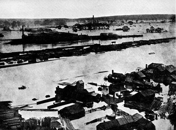
The Great Flood of October 1875.
(View from Nottingham Castle looking South.)
It will be seen from the above account that whereas the smaller floods usually inundate the lower and recent alluvial plain, mostly meadow and pasture land, the more severe floods (e.g. 1875) cover large tracts of the higher-lying river gravels of the ancient Trent, now occupied by such villages as West Bridgford, Fiskerton, Collingham, Holme, Girton, and Dunham.
Blown Sands
As we trace the gravels northwards from Nottingham to Newark, and thence to the Humber, the stones of which they are composed are noticed to become increasingly finer, and there is much more sand mixed with them. During the later days of the ancient Trent, when its waters kept altering their courses, the river channels, when dry, laid bare the sand, which was caught up by the prevalent winds—then, as now, blowing from the south-west. The sand was swept up on to the higher parts of the river plain, and accumulated as dunes near what is now the main road from Collingham to the north.
Although to some extent fixed in position by the growth of grasses and gorse, and partly destroyed or levelled by agricultural operations, there still remain enough dunes to give a characteristic seaside-like appearance to the district, especially near Girton and Besthorpe. It is interesting to note that, since a part of the tract has been brought into cultivation, the drifting has again commenced, the sand being piled up in the north-east corner of every arable field, and swept away from the south-west corner. The direction of the winds which formed the original dunes also accounts for the nearly complete absence of blown sands on the western side of the Trent valley below Newark.
It is related that in the coaching days wheeled traffic often experienced considerable difficulty in passing along the high road near Besthorpe and Girton because of the great depth of the sand which had been blown into it from the dunes.
Changes in the Course of the Trent
We have seen that the ancient Trent wandered freely over its gravelly flood-plain, splitting up rapidly into branches, and abruptly altering parts of its course with every flood. Nowadays, although floods still occur, the river’s course is more or less controlled by flood-banks, and the chief changes are due to the slow action of the river swinging into and undermining its bank as it sweeps round its curves; yet, even within historical times, we have records of sudden changes in course. These changes are of two classes—firstly, those in which the river has found a new channel through the old gravels; and, secondly, those in which the river has shortened its course on its present alluvium. As examples of the first class we may cite the cases of Kelham and Muskham.
Rastall, quoting from an autograph of Thomas Heron of Newark, says: “Where the main stream now runs by Kelham there was a small brook which, not being sufficient for the various purposes of the Sutton family resident there, a cut was made from the Trent to the brook which gave a turn to the whole current ... it then forced its way and formed that channel which is now seen. There were carriage bridges over the brook at Kelham and Muskham ... and they were obliged to build bridges over the new and extended river.” This probably occurred before 1225, because tolls were at that date collected at Kelham Bridge.
According to Dickinson and Throsby, the hamlet of Holme was attached to the parish of North Muskham, until the Trent, in A.D. 1600, separated the two places during a high flood (Fig. 3). Saxton’s map, however, published about 1576, shows Holme already cut off. A will of Stephen Surflett, of the same date, leaves land for the maintenance of the water-bank at Holme; it is therefore probable that the change took place in Surflett’s lifetime. The alluvium between Muskham and Holme is three times the width of the stream, whilst that at Kelham is no wider than the river itself; but whereas the Kelham cut was nearly straight, that at Holme must have followed a winding course: subsequent movement of the meanders down stream would account for the greater width of the alluvial strip. An old man living at Holme last century remembered a barge sinking in the river on a spot, now an orchard, 100 yards from the stream.
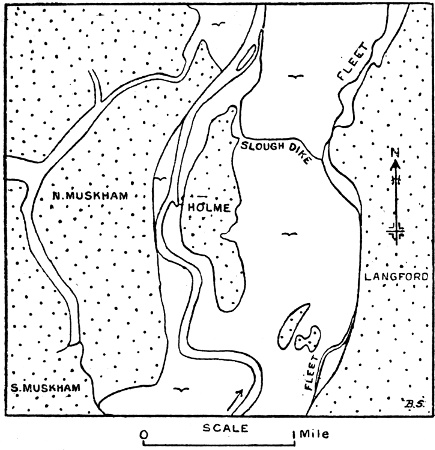
Fig. 3.—The Trent separating Holme from North Muskham.
The stippled areas are gravel.
Changes in course on the recent alluvium have taken place sometimes by artificial means, but usually in a natural manner.
The Nottingham Borough Records for 1392 give an account of a “Process against the Lord of Colwick for obstructing the course of the Trent,” the substance of which is that William de Colwick, Knight, and one Richard Byron, Knight, and others, have diverted the waters of Trent from its ancient course at Over Colwick into a trench, by which a portion of the said water of Trent formerly held its course, by planting obstructions, such as willows and piles. The water totally left its former course and ran by the aforesaid trench to the mill in Over Colwick, where a closed “wear” was made. The former course, about 1¾ miles in length, between the village of Adbolton and the village of Over Colwick, was destroyed and filled up by sand, willows, and other obstructions, so that ships could not come up the river to Nottingham for nine years.
In judgment the “wear” and all other nuisances were ordered to be cast down and removed. The mill-weir was apparently destroyed, but the water held to the diverted course (i.e. the trench by which a portion of the said water of Trent formerly held its course). The ancient course is the Old Trent now defining parts of the boundaries of Colwick and the Borough of Nottingham. In some manuscript notes from the “Perambulation of the Forest of Sherwood [31st Queen Elizabeth]”, by Launcelott Rolston and others, it is stated that the boundary “ascendeth by the River of Trent, by the Abbey of Shelforde wch is on the Southe pte of the Trente, and above the same Abbey it doth followe the ould course and streame of the Trente whch there is dryven of the north pte from its ould course and so ascendeth still to Collwicke by the River of Trente and so to Nottingham Bridge.” The above-mentioned “old course” is still traceable to the west and south-west of Shelford.
Instead of passing Kelham, as at present, the Trent, or a branch of it, formerly passed Newark some 345 yards distant from the castle, and joined the Devon below the town. This Old Trent, now a mere trickle in a narrow winding valley, separates the hundred of Newark from that of Thurgarton. Above Newark an artificial cut connects the Old Trent with the Devon, which, after flowing beneath the castle, joins the Trent at Crankley Point 1½ miles down stream. The arrangement is shown in an old map of 1558 in C. Brown’s History of Newark.
At some unrecorded date the stream has cut off from Carlton parish a field upon which the villagers still exercise right of pasturing cattle. This field, Carlton Home, by its uneven surface, appears to have been formed by lateral movement of the river; the old flood-bank may have fixed the parish boundary (Fig. 2).
Sutton South Holme was an island in 1834; a part of the western stream-course still exists as a long pool. Across the river, and belonging to Sutton, is Smithy (Smeemus) Marsh, a pasture some 120 acres in extent. A bank, ditch, and the parish boundary on the east fix the site of the Old Trent, which changed its course before the date of Saxton’s map.
South of Clifton Hill, east of the Trent, an old meandering course, more than a mile long, cuts off a piece of ground known as “The Ropes.” This old course is probably of great antiquity, because it was the boundary of four parishes; it was once half the width of the Trent (Fig. 2). Other old courses may be seen on Marnham Holme, Fledborough Holme, and under Newton Cliff. The island south of Dunham Bridge, shown on maps from 1794–1834, was shaped like an inverted Welsh harp. The river invaded a neighbouring drainage-channel at the turn of a meander, which has since progressed down stream, as shown by the necessity for a new tow-path bank.
Old and deserted meandering channels and dying pools occur in such numbers on the recent alluvium that the conclusion is forced upon us that, without embankments, the valley would rapidly revert to a state of wildness similar to those of the rivers of young countries (e.g. the Mississippi Valley, where channels and pools occur in great numbers).
Evidences of recent lateral movement are extremely numerous; the example at Holme given above is a case in point. Roman pottery occurs in the gravel on the west bank above the site of the Roman bridge near Cromwell, where the river runs straight; and a block of dressed Blue-Lias stone was recently found here upon the site of the new lock, at least 25 feet from the present (river) bank. Again, in A.D. 1649 a field, situated beyond the Trent, but in Collingham parish, once of 35 acres, had been reduced to 8 acres by encroachment.
Near the “Crankleys,” about a mile north of Newark, an old loop of the Trent forms a curved “ox-bow” lake. This loop appears as a right-angled bend in a map (revised and published in 1725) drawn up by the chief engineer of the Scottish army besieging Newark in 1646. It also appears in Chapman’s map of 1774. In 1861 the Great Northern Railway was carried across the then well-developed loop, and to facilitate operations the bridge was first built upon the neck of the loop and the river diverted to a new channel cut across the neck beneath the bridge. Human remains, of Neolithic Age, with antlers of deer and bones of ox and horse, were found beneath the bridge at a depth of 25 feet, having been deposited in the bed of the river when it happened to be flowing at that spot. By lateral movement of the river the remains were entombed until thus brought to light.
The lateral movement and windings of the “smug and silver Trent” were evidently well known to Shakespeare, for in King Henry IV., Part I., Hotspur and Glendower are warmly debating about one of the meanders north of Burton. Hotspur suggests straightening the river’s course, but Glendower will not have it altered. The meander referred to is apparently one of the abandoned “rounds” near Burton and Bole, nearly opposite Gainsborough. In Shakespeare’s time they would have been much more like huge half-moons—to use Hotspur’s expression—than like circles, such as Burton Round.
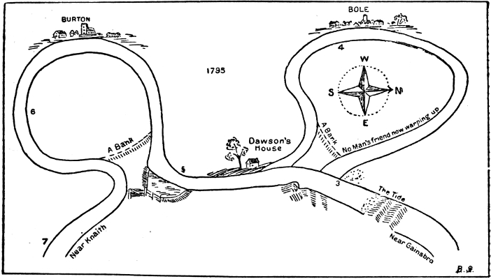
Fig. 4.—Burton and Bole Rounds, after a map by Mr. Gurnill, Sen., Gainsborough, 1795.
By 1790 the necks of the loops were almost severed, and in February 1792 the Bole Round was breached by the river, possibly aided by the Trent bore or “ægir”—an event celebrated three years later by a Mr. Gurnill, senior, of Gainsborough, who published a map (a copy is in the possession of Mr. J. S. Lamb, of Beckingham) showing that the other loop (Burton) would soon suffer the same fate. The first vessel to pass through the breach was the property of Mr. James Cuttle, of Lincoln. White’s Directory of Nottinghamshire for 1832 states that “Until 1797 the Trent here (Burton) took such a circular sweep that a boatman might have thrown his hat on shore, and, after sailing two miles, have taken it up again, but in that year the stream forced itself through the narrow neck of land in a straight line, in consequence of which the old winding channel was filled up and divided betwixt the counties of Nottingham and Lincoln, besides which the latter had now about one hundred acres on the west side of the course of the present river.” Both rounds have recently been transferred to Nottinghamshire, and remain as swampy hollows in Burton and Bole parishes, whose boundaries they partly define.
Dr. Wake and others assume that the floods are efforts of the Trent to regain its old channel, now occupied by the Fleet stream, which is undoubtedly a part of the old river (Figs. 2 and 3). Between Langford and Girton there is a low westerly-facing cliff or terrace of gravel and sand, beneath which the Fleet stream flows from Winthorpe to join the Trent near Girton. The relations between the cliff and the alluvial flat make it clear that the Trent has worked along different parts of the cliff at one time or another. The expansions at Langford, Besthorpe, and Girton, and formerly at North and South Collingham, must also be regarded as relics of the old Trent; but whether it flowed beneath the whole length of the gravel cliff at one and the same time is an open question.
The river has certainly moved from east to west, and is still doing so, having on its right hand a well-dissected gravel plain, on its left an unbroken sheet of gravel upon which it tends to encroach. It first left the Wath Bank (Spalford) at some time before 900 A.D., according to Wake, when the hundreds were defined; deserted the Fleet Mere between the tenth and sixteenth centuries, and lastly separated Holme from Muskham. There were possibly also intermediate stages when the river cut through from North Collingham to Carlton Rack, and when the Kelham parish boundary was crossed.
Thus the old story is repeated. The ancient waters flowed directly from Newark to Lincoln, then some of them fell away to the west to find exit by the Humber. Now the river flows in a northerly direction, but is edging to the west side of its valley—an effect probably due to freer egress through the remarkably narrow gap between the Keuper hills of Marnham and South Clifton, which would tend to shorten and straighten the course as far south as Kelham and Averham.
The Trent has from very early times been a means of communication and a highway. Domesday Book records that the water of Trent was kept so that if any should hinder the passage of boats he should make amends. Henry I. gave the Bishop of Lincoln permission to erect a bridge at Newark, “so that it may not hurt my city of Lincoln nor my borough of Nottingham.” Acts of Parliament relating to the navigation were passed between 1699 and 1794, and troubles about weirs arose as early as 1292. These and other instances mentioned above show that importance was attached to the control of the waters from fairly early times.
The Trent is supposed to be a tamed river. Its banks are fortified by flood-banks, piles, stones, cement, and even sunken barges; yet it persists in meandering. As fast as it undermines the flood-bank, the latter is repaired from the outside, hence the river, as it were, pushes the outer flood-bank before it when vigorously swinging outwards, but leaves the inner bank isolated by deposit of sediment. A second or inner bank then becomes necessary to carry the tow-path. Again, if the natural swing of the river is tampered with, it retaliates by readjusting its course below the point of interference. Thus, although tamed, the river under certain conditions has its own way, and never in more striking manner than when, overlapping its flood-banks, it bursts its bonds and surges far and wide over the broad Vale of Trent.[45]