Chapter XI · —The Anthropo-Geography Of Rivers
Reading edition
Rivers as intermediaries between land and sea.
To a large view, rivers appear in two aspects. They are either part of the general water envelope of the earth, extensions of seas and estuaries back into the up-hill reaches of the land, feeders of the ocean, roots which it spreads out over the surface of the continents, not only to gather its nourishment from ultimate sources in spring and glacier, but also to bring down to the coast the land-born products of the interior to feed a sea-born commerce; or rivers are one of the land forms, merely water filling valley channels, serving to drain the fields and turn the mills of men. In the first aspect their historical importance has been both akin and linked to that of the ocean, despite the freshness and smaller volume of their waters and the unvarying direction of their currents. The ocean draws them and their trade to its vast basin by the force of gravity. It unites with its own the history of every log-stream in Laurentian or Himalayan forest, as it formerly linked the beaver-dammed brooks of wintry Canada with the current of trade following the Gulf Stream to Europe.
Sea navigation merges into river navigation.
Historical importance of seas and oceans influenced by their debouching streams.
Baltic and White Sea rivers.
Atlantic and Pacific rivers.
If we compare the Atlantic and Pacific oceans in respect to their rivers, we find that the narrow Atlantic has a drainage basin of over 19,000,000 square miles as opposed to the 8,660,000 square miles of drainage area commanded by the vastly larger Pacific. The Pacific is for the most part rimmed by mountains, discharging into the ocean only mad torrents or rapid-broken streams. The Atlantic, bordered by gently sloping plains of wide extent, receives rivers that for the most part pursue a long and leisurely course to the sea. Therefore, the commercial and cultural influences of the Atlantic extend from the Rockies and Andes almost to the heart of Russia, and by the Nile highway they even invade the seclusion of Africa. Through the long reach of its rivers, therefore, the Atlantic commands a land area twice as great as that of the Pacific; and by reason of this fundamental geographic advantage, it will retain the historical preëminence that it so early secured. The development of the World Ocean will mean the exploitation of the Pacific trade from the basis of the Atlantic, the domination of the larger ocean by the historic peoples of the smaller, because these peoples have wider and more accessible lands as the base of their maritime operations.
Lack of coast articulations supplied by rivers.
River highways as basis of commercial preeminence.
Importance of rivers in large countries.
In countries of large area, where commerce and intercourse must cover great distances, these natural and therefore cheap highways assume paramount importance, especially in the forest and agricultural stages of development, when the products of the land are bulky in proportion to their value. Small countries with deeply indented coasts, like Greece, Norway, Scotland, New England, Chile, and Japan, can forego the advantage of big river systems; but in Russia, Siberia, China, India, Canada, the United States, Venezuela, Brazil and Argentine, the history of the country, economic and political, is indissolubly connected with that of its great rivers. The storm center of the French and English wars in America was located on the upper Hudson, because this stream enabled the English colonies to tap the fur trade of the Great Lakes, and because it commanded the Mohawk Valley, the easiest and most obvious path for expansion into the interior of the continent. The Spanish, otherwise confining their activities in South America to the Caribbean district and the civilized regions of the Andean highlands, established settlements at the mouth of the La Plata River, because this stream afforded an approach from the Atlantic side toward the Potosi mines on the Bolivian Plateau. The Yangtze Kiang, that great waterway leading from the sea across the breadth of China and the one valuable river adjunct of maritime trade in the whole Orient, was early appropriated by the discerning English as the British "sphere of influence."
Rivers as highways of expansion.
No other equally large area of the earth is so generously equipped by nature for the production and distribution of the articles of commerce as southern Canada and that part of the United States lying east of the Rocky Mountains. The simple build of the North American continent, consisting of a broad central trough between distant mountain ranges, and characterized by gentle slopes to the Atlantic Ocean and the Gulf of Mexico, has generated great and small rivers with easy-going currents, that everywhere opened up the land to explorer, trader and settler. The rate of expansion from the "Europe-fronting shore" of the continent was everywhere in direct proportion to the length of the rivers first appropriated by the colonists. North of Chesapeake Bay the lure to landward advance was the fur trade. The Atlantic rivers of the coast pre-empted by the English were cut short by the Appalachian wall. They opened up only restricted fur fields which were soon exhausted, so that the migrant trapper was here early converted into the agricultural settler, his shifting camp fire into the hearthstone of the farmhouse. Expansion was slow but solid. The relatively small area rendered accessible by their streams became compactly filled by the swelling tide of immigrants and the rapid natural increase of population. In sharp contrast to this development, the long waterway of the St. Lawrence and the Great Lakes leading to the still vaster river system of the Mississippi betrayed the fur-trading French into excessive expansion, and enabled them to appropriate but not to hold a vast extent of territory. A hundred years after the arrival of Champlain at Montreal, they were planting their fur stations on Lake Superior and the Mississippi, 1,400 miles (2,300 kilometers) back from the coast, at a time when the English settlements had advanced little beyond tide-water. And when after 1770 the westward movement swept the backwoodsmen of the English colonies over the Appalachian barrier to the Ohio, Cumberland and Tennessee, these long westward flowing streams carried them rapidly on to the Mississippi, communicated the mobility and restlessness of their own currents to the eager pioneer, and their capacity to master great distances; so that in forty short years, by 1810, settlements were creeping up the western tributaries of the Mississippi. The abundant water communication in the Mississippi Valley, which even for present large river craft contains 15,410 miles of navigable streams and which had therefore a far greater mileage in the day of canoe and flatboat, afforded outlet for bulky, backwoods produce to the sea at New Orleans. When the English acquired Canada in 1763, they straightway fell under the sway of its harsh climate and long river systems, taking up the life of the fur trader; they followed the now scarcer pelts from the streams of Superior westward by Lake Winnipeg and along the path of the Saskatchewan River straight to the foot of the Rockies.
Siberian rivers and Russian expansion.
As the only highways in new countries, rivers constitute lines of least resistance for colonial peoples encroaching upon the territory of inferior races. They are therefore the geographic basis of those streamers of settlement which we found making a fringe of civilization across the boundary zone of savagery or barbarism on the typical colonial frontier. Ethnic islands of the expanding people cluster along them like iron filings on a magnetized wire. Therefore in all countries where navigable rivers have fixed the lines of expansion, as in the United States, the northern part of the Russian Empire, and the eastern or colonial border of Germany and Austria, there is a strong anthropo-geographic resemblance in the frontiers of successive decades or centuries. But in arid or semi-arid regions like South Africa, the western plains of North America, the steppes of Russian and Chinese Turkestan, the river highway motif in expansion is lost in a variety of other geographic and geologic factors, though the water of the streams still attracts trail and settlement.
Determinants of routes in arid or semi-arid lands.
Wadi routes in arid lands.
Increasing historical importance from source to mouth.
The control of a river mouth becomes a desideratum or necessity to the upstream people. Otherwise they may be bottled up. Though history shows us countless instances of upstream expansion, nevertheless owing to the ease of downstream navigation and this increasing historical importance from source to mouth, the direction of a river's flow has often determined the course of commerce and of political expansion.
Location at hydrographic centers.
Effect of current upon trade and expansion.
The effect of mere current upon the course of trade and political expansion was conspicuous in the early history of the Mississippi Valley, before steam navigation began to modify the geographic influence of a river's flow. The wide forest-grown barrier of the Appalachian Mountains placed the western pioneers under the geographic control of the western waters. The bulkiness of their field and forest products, fitted only for water transportation, and the immense mass of downstream commerce called loudly for a maritime outlet and the acquisition from Spain of some port at the Mississippi mouth. For twenty years the politics of this transmontane country centered about the "Island of New Orleans," and in 1803 saw its dream realized by the Louisiana Purchase.
Importance of mouth to upstream people.
Prevention of monopoly of river mouth.
Motive for canals in lower course.
Watershed canals.
Rivers and railroads.
Relation of rivers to railroads in recent colonial lands.
Unity of a river system.
The effect of common water supply in arid lands.
Union of opposite river banks.
Tendency toward ethnic and cultural unity in a river valley.
Identity of country with river valley.
In mountain regions which are also arid, the identity of a district with a stream basin becomes yet more pronounced, because here population must gather about the common water supply, must organize to secure its fair distribution, and cooperate in the construction of irrigation channels to make the distribution as economical and effective as possible. Thus in Chinese Turkestan, the districts of Yarkand, Kashgar, Aksu and Kut-sha are identical with as many mountain tributaries of the Tarim, whose basin in turn comprises almost the whole of Chinese Turkestan.
Enclosed river valleys.
In all such desert and mountain-rimmed valleys, the central stream attracts to its narrow hem of alluvial soil the majority of the population, determines the course of the main highroad, and is itself often the only route through the encompassing barriers. Hence the importance attached to the river by the inhabitants, an importance reflected in the fact that the river often gives its name to the whole district. To the most ancient Greeks Aigiptos meant the river, whose name was later transferred to the whole land; for the narrow arable strip which constituted Egypt was "the gift of the Nile." The Aryans, descending into India through the mountains on its northwest border, gave the name of Sindhu, "the flood" or "the ocean," to the first great river they met. In the mouth of Persians and Greeks the name was corrupted into Indus, and then applied to the whole country; but it still survives in its original form in the local designation of the Sind province, which comprises the valley of the Indus below the confluence of the five rivers, which again formed and named the original Punjab. Significantly enough the western political boundary of the Sind extends into the barren foothills of Baluchistan only so far as the affluents of the Indus render the land arable by irrigation; for the Indus performs for the great province of the Sind, by annual inundation and perennial irrigation, the same service that the Nile does for Egypt.
The segregation of such districts, and the concentration of their interests and activities along the central streams have tended to develop in the population an intense but contracted national consciousness, and to lend them a distinctive history. Their rivers become interwoven with their mythology and religion, are gods to be worshipped or appeased, become goals of pilgrimages, or acquire a peculiar sanctity. The Nile, Ganges, Jamna, Jordan, Tiber and Po are such sacred streams, while the Rhine figures in German mythology.
Rivers as boundaries of races and peoples.
The statements of Cæsar and Pliny that the Seine and Marne formed the boundary between the Gauls and Belgians, and the Garonne that between the Gauls and Aquitanians, must be accepted merely as general and preliminary; for exceptions are noted later in the text. Parisii, for instance, were represented as holding both banks of the Seine and Marne at their confluence, and the Gallic Bituriges were found on the Aquitanian side of the Garonne estuary.
Scientific river boundaries.
Rivers as political boundaries.
Fluvial settlements and peoples.
Riparian villages of French Canada.
The presence of the great waterways of Canada and the demand of the fur trade for extensive and easy communication made the early French colonists as distinctly a riverine people as the savage Congo tribes. Like these, they stretched out their villages in a single line of cabins and clearings, three or four miles long, facing the river, which was the King's highway. Such a village was called a côte. One côte ran into the next, for their expansion was always longitudinal, never lateral. These riparian settlements lined the main watercourses of French Canada, especially the St. Lawrence, whose shores from Beaupre, fifteen miles below Quebec, up to Montreal at an early date presented the appearance of a single street. Along the river passed the stately trading ship from France with its cargo of wives and merchandise for the colonists, the pirogue of the habitant farmer carrying his onions and grain to the Quebec market, the birchbark canoe of the adventurous voyageur bringing down his winter's hunt of furs from the snow-bound forests of the interior, and the fleet of Jesuit priests bound to some remote inland mission.
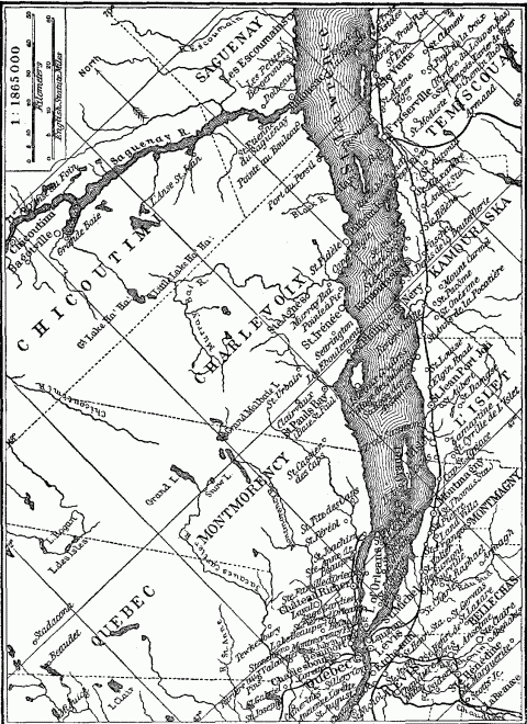
The Riparian Villages Of The Lower St. Lawrence.
Boatmen tribes or castes.
River islands as protected sites.
River and lake islands as robber strongholds.
River peninsulas as protected sites.
River islands as sites of trading posts and colonies.
Swamps as barriers and boundaries.
Swamps as regions of survival.
Swamps as places of refuge.
The spirit of the marshes.
Economic and political importance of lakes.
A river that spreads out into the indeterminate earthform of a marsh is an effective barrier; but one that gathers waters into a natural basin and forms a lake retains the uniting power of a navigable stream and also, by the extension of its area and elimination of its current, approaches the nature of an enclosed sea. Mountain rivers, characterized by small volume and turbulent flow, first become navigable when they check their impetuosity and gather their store of water in some lake basin. The whole course of the upper Rhone, from its glacier source on the slope of Mount Furca to its confluence with the Saône at Lyon, is unfit for navigation, except where it lingers in Lake Geneva. The same thing is true of the Reuss in Lake Lucerne, the upper Rhine in Lake Constance, the Aare in Thun and Brienze, and the Linth in Lake Zurich. Hence such torrent-fed lakes assume economic and political importance in mountainous regions, owing to the paucity of navigable waterways. The lakes of Alpine Switzerland and Italy and of Highland Scotland form so many centers of intercourse and exchange. Even such small bodies of water as the Alpine lakes have therefore become goals of expansion, so that we find the shores of Geneva, Maggiore, Lugano, and Garda, each shared by two countries. Switzerland, the Austrian Tyrol, and the three German states of Baden, Wurtemberg and Bavaria, have all managed to secure a frontage upon Lake Constance. Lake Titicaca, lying 12,661 feet (3854 meters) above sea level but affording a navigable course 136 miles (220 kilometers) long, is an important waterway for Peru and Bolivia. In the central Sudan, where aridity reduces the volume of all streams, even the variable and indeterminate Lake Chad has been an eagerly sought objective for expanding boundaries. Twenty years ago it was divided among the native states of Bornu, Bagirmi and Kanem; today it is shared by British Nigeria, French Sudan, and German Kamerun. The erratic northern extension of the German boundary betrays the effort to reach this goal.
Lakes as nuclei of states.
Large lakes, which include in their area islands, peninsulas, tides, currents, fiords, inlets, deltas, and dunes, and present every geographical feature of an enclosed sea, approach the latter too in historical importance. Some of the largest, however, have long borne the name of seas. The Caspian, which exceeds the Baltic in area, and the Aral, which outranks Lake Michigan, show the closest physical resemblance to thalassic basins, because of their size, salinity and enclosed drainage systems; but their anthropo-geographical significance is slight. The very salinity which groups them with the sea points to an arid climate that forever deprives them of the densely populated coasts characteristic of most enclosed seas, and hence reduces their historical importance. Their tributary streams, robbed of their water by irrigation canals, like "the shorn and parcelled Oxus", renounce their function of highways into the interior. To this rule the Volga is a unique exception. Finally, cut off from union with the ocean, these salt lakes lose the supreme historical advantage which is maintained by freshwater lakes, like Ladoga, Nyassa, Maracaibo and the Great Lakes of North America, all lying near sea level.
Lakes as fresh water seas.
Lakes as part of a system of inland waterways may possess commercial importance surpassing that of many seas. This depends upon the productivity, accessibility and extent of their hinterland, and this in turn depends upon the size and shape of the inland basin. The chain of the five Great Lakes, which together present a coastline of four thousand miles and a navigable course as long as the Baltic between the Skager Rack and the head of the Gulf of Bothnia, constitutes a freshwater Mediterranean. It has played the part of an enclosed sea in American history and has enabled the Atlantic trade to penetrate 1400 miles inland to Chicago and Duluth. Its shores have therefore been a coveted object of territorial expansion. The early Dutch trading posts headed up the Hudson and Mohawk toward Lake Ontario, as did the English settlements which succeeded them. The French, from their vantage point at Montreal, threw out a frail casting-net of fur stations and missions, which caught and held all the Lakes for a time. Later the American shores were divided among eight of our states. The northern boundaries of Indiana and Illinois were fixed by Congress for the express purpose of giving these commonwealths access to Lake Michigan. Pennsylvania with great difficulty succeeded in protruding her northwestern frontier to cover a meager strip of Erie coast, while New York's frontage on the same lake became during the period of canal and early railroad construction, a great factor in her development.
NOTES TO CHAPTER XI