Chapter VIII · —Coast Peoples
Reading edition
The coast a zone of transition.
Of all geographical boundaries, the most important is that between land and sea. The coast, in its physical nature, is a zone of transition between these two dominant forms of the earth's surface; it bears the mark of their contending forces, varying in its width with every stronger onslaught of the unresting sea, and with every degree of passive resistance made by granite or sandy shore. So too in an anthropo-geographical sense, it is a zone of transition. Now the life-supporting forces of the land are weak in it, and it becomes merely the rim of the sea; for its inhabitants the sea means food, clothes, shelter, fuel, commerce, highway, and opportunity. Now the coast is dominated by the exuberant forces of a productive soil, so that the ocean beyond is only a turbulent waste and a long-drawn barrier: the coast is the hem of the land. Neither influence can wholly exclude the other in this amphibian belt, for the coast remains the intermediary between the habitable expanse of the land and the international highway of the sea. The break of the waves and the dash of the spray draw the line beyond which human dwellings cannot spread; for these the shore is the outermost limit, as for ages also in the long infancy of the races, before the invention of boat and sail, it drew the absolute boundary to human expansion. In historical order, its first effect has been that of a barrier, and for the majority of peoples this it has remained; but with the development of navigation and the spread of human activities from the land over sea to other countries, it became the gateway both of land and sea—at once the outlet for exploration, colonization, and trade, and the open door through which a continent or island receives contributions of men or races or ideas from transoceanic shores. Barrier and threshold: these are the rôles which coasts have always played in history. To-day we see them side by side. But in spite of the immense proportions assumed by transmarine intercourse, the fact remains that the greater part of the coasts of the earth are for their inhabitants only a barrier and not an outlet, or at best only a base for timorous ventures seaward that rarely lose sight of the shore.
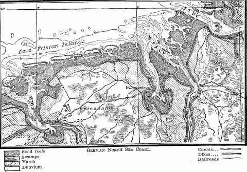
German North Sea Coast.
Width of coastal zones.
As intermediary belt between land and sea, the coast becomes a peculiar habitat which leaves its mark upon its people. We speak of coast strips, coastal plains, "tidewater country," coast cities; of coast tribes, coast peoples, maritime colonies; and each word brings up a picture of a land or race or settlement permeated by the influences of the sea. The old term of "coastline" has no application to such an intermediary belt, for it is a zone of measurable width; and this width varies with the relief of the land, the articulation of the coast according as it is uniform or complex, with the successive stages of civilization and the development of navigation among the people who inhabit it.
Along highly articulated coasts, showing the interpenetration of sea and land in a broad band of capes and islands separated by tidal channels and inlets, or on shores deeply incised by river estuaries, or on low shelving beaches which screen brackish lagoons and salt marshes behind sand reefs and dune ramparts, and which thus form an indeterminate boundary of alternate land and water, the zone character of the coast in a physical sense becomes conspicuous. In an anthropological sense the zone character is clearly indicated by the different uses of its inner and outer edge made by man in different localities and in different periods of history.
The inner edge.
Inner edge as head of sea navigation.
While, on low coasts at any rate, the inner edge tends to mark the limit of settlement advancing from the interior, as the head of sea navigation on river and inlet it has also been the goal of immigrant settlers from oversea lands. The history of modern maritime colonization, especially in America, shows that the aim of regular colonists, as opposed to mere traders, has been to penetrate as far as possible into the land while retaining communication with the sea, and thereby with the mother country. The small boats in use till the introduction of steam navigation fixed this line far inland and gave the coastal zone a greater breadth than it has at present, and a more regular contour. In colonial America this inner edge coincided with the "fall-line" of the Atlantic rivers, which was indicated by a series of seaport towns; or with the inland limit of the tides, which on the St. Lawrence fell above Quebec, and on the Hudson just below Albany.
Shifting of the inner edge.
Artificial extension of inner edge.
The width of the coast zone is not only prevented from contracting by dredging and canaling, but it is even increased. By deepening the channel, the chief port of the St. Lawrence River has been removed from Quebec 180 miles upstream to Montreal, and that of the Clyde from Port Glasgow 16 miles to Glasgow itself, so that now the largest ocean steamers come to dock where fifty years ago children waded across the stream at ebb tide. Such artificial modifications, however, are rare, for they are made only where peculiarly rich resources or superior lines of communication with the hinterland justify the expenditures; but they find their logical conclusion in still farther extensions of sea navigation into the interior by means of ship canals, where previously no waterway existed. Instances are found in the Manchester ship canal and the Welland, which, by means of the St. Lawrence and the Great Lakes, makes Chicago accessible to ocean vessels. Though man distinguishes between sea and inland navigation in his definitions, in his practice he is bound by no formula and recognizes no fundamental difference where rivers, lakes, and canals are deep enough to admit his sea-going craft.
Such deep landward protrusions of the head of marine navigation at certain favored points, as opposed to its recent coastward trend in most inlets and rivers, increase the irregularity of the inner edge of the coast zone by the marked discrepancy between its maximum and minimum width. They are limited, however, to a few highly civilized countries, and to a few points in those countries. But their presence testifies to the fact that the evolution of the coast zone with the development of civilization shows the persistent importance of this inner edge.
Outer edge in original settlement.
Outer edge in early navigation.
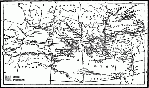
Map Of Ancient Phoenician And Greek Colonies.
Outer edge and piracy.
Outer edge in colonization.
Inland advance of colonies.
Interpenetration of land and sea.
Since it is from the land, as the inhabited portion of the earth's surface, that all maritime movements emanate, and to the land that all oversea migrations are directed, the reciprocal relations between land and sea are largely determined by the degree of accessibility existing between the two. This depends primarily upon the articulation of a land-mass, whether it presents an unbroken contour like Africa and India, or whether, like Europe and Norway, it drops a fringe of peninsulas and a shower of islands into the bordering ocean. Mere distance from the sea bars a country from its vivifying contact; every protrusion of an ocean artery into the heart of a continent makes that heart feel the pulse of life on far-off, unseen shores. The Baltic inlet which makes a seaport of St. Petersburg 800 miles (1,300 kilometers) back from the western rim of Europe, brings Atlantic civilization to this half-Asiatic side of the continent. The solid front presented by the Iberian Peninsula and Africa to the Atlantic has a narrow crack at Gibraltar, whence the Mediterranean penetrates inland 2,300 miles (3,700 kilometers), and converts the western foot of the Caucasus and the roots of the Lebanon Mountains into a seaboard. By means of the Arabian Sea, the Indian Ocean runs northward 1,300 miles (2,200 kilometers) from Cape Comorin to meet the Indus delta; and then turns westward 700 miles farther through the Oman and Persian gulfs to receive the boats from the Tigris and Euphrates. Such marine inlets create islands and peninsulas; which are characterized by proximity to the sea on all or many sides; and in the interior of the continents they produce every degree of nearness, shading off into inaccessible remoteness from the watery highway of the deep.
The success with which such indentations open up the interior of the continents depends upon the length of the inlets and the size of the land-mass in question. Africa's huge area and unbroken contour combine to hold the sea at arm's length, Europe's deep-running inlets open that small continent so effectively that Kazan, Russia's most eastern city of considerable size, is only 750 miles (1,200 kilometers) distant from the nearest White Sea, Baltic, and Azof ports. Asia, the largest of all the continents, despite a succession of big indentations that invade its periphery from Sinai peninsula to East Cape, has a vast inland area hopelessly far from the surrounding oceans.
Ratio of shoreline to area.
The criticism has been made against this method that it compares two unlike measures, square and linear, which moreover increase or decrease in markedly different degrees, according as larger or smaller units are used. But for the purposes of anthropo-geography the method is valid, inasmuch as it shows the amount of area dependent for its marine outline upon each mile of littoral. A coast, like every other boundary, performs the important function of intermediary in the intercourse of a land with its neighbors; hence the length of this sea boundary materially affects this function. Area and coastline are not dead mathematical quantities, but like organs of one body stand in close reciprocal activity, and can be understood only in the light of their persistent mutual relations. The division of the area of a land by the length of its coastline yields a quotient which to the anthropo-geographer is not a dry figure, but an index to the possible relations between seaboard and interior. A comparison of some of these ratios will illustrate this fact.
Criticism of this formula.
But this method is open to the legitimate and fundamental criticism that, starting from the conception of a coast as a mere line instead of a zone, it ignores all those features which belong to every littoral as a strip of the earth's surface—location, geologic structure, relief, area, accessibility to the sea in front and to the land behind, all which vary from one part of the world's seaboard to another, and serve to differentiate the human history of every littoral. Moreover, of all parts of the earth's surface, the coast as the hem of the sea and land, combining the characters of each, is most complex. It is the coast as a human habitat that primarily concerns anthropo-geography. A careful analysis of the multifarious influences modifying one another in this mingled environment of land and water reveals an intricate interplay of geographic forces, varying from inland basin to marginal sea, from marginal sea to open ocean, and changing from one historical period to another—an interplay so mercurial that it could find only a most inadequate expression in the rigid mathematical formula of Carl Ritter.
Accessibility of coasts from hinterland.
As the coast, then, is the border zone between the solid, inhabited land and the mobile, untenanted deep, two important factors in its history are the accessibility of its back country on the one hand, and the accessibility of the sea on the other. A littoral population barred from its hinterland by mountain range or steep plateau escarpment or desert tract feels little influence from the land; level or fertile soil is too limited in amount to draw inland the growing people, intercourse is too difficult and infrequent, transportation too slow and costly. Hence the inhabitants of such a coast are forced to look seaward for their racial and commercial expansion, even if a paucity of good harbors limits the accessibility of the sea; they must lead a somewhat detached and independent existence, so far as the territory behind them is concerned. Here the coast, as a peripheral organ of the interior, as the outlet for its products, the market for its foreign exchanges, and the medium for intercourse with its maritime neighbors, sees its special function impaired. But it takes advantage of its isolation and the protection of a long sea boundary to detach itself politically from its hinterland, as the histories of Phoenicia, the Aegean coast of Asia Minor, Dalmatia, the republics of Amalfi, Venice, and Genoa, the county of Barcelona, and Portugal abundantly prove. At the same time it profits by its seaboard location to utilize the more varied fields of maritime enterprise before it, in lieu of the more or less forbidden territory behind it. The height and width of the landward barrier, the number and practicability of the passways across it, and especially the value of the hinterland's products in relation to their bulk, determine the amount of intercourse between that hinterland and its mountain or desert barred littoral.
Mountain-barred hinterlands.
Accessible hinterlands.
Accessibility of coasts from the sea.
Embayed coasts.
Maritime activity on steep embayed coasts.
Contrasted coastal belts.
As areas of elevation or subsidence are, as a rule, extensive, it follows that coasts usually present long stretches of smooth simple shoreline, or a long succession of alternating inlet and headland. Therefore different littoral belts show marked contrasts in their degree of accessibility to the sea, and their harbors appear in extensive groups of one type—fiords, river estuaries, sand or coral reef lagoons, and embayed mountain roots. A sudden change in relief or in geologic history sees one of these types immediately succeeded by a long-drawn group of a different type. Such a contrast is found between the Baltic and North Sea ports of Denmark and Germany, the eastern and southern seaboards of England, the eastern and western sides of Scotland, and the Pacific littoral of North America north and south of Juan de Fuca Strait, attended by a contrasted history.
A common morphological history, marked by mountain uplift, glaciation, and subsidence, has given an historical development similar in not a few respects to the fiord coasts of New England, Norway, Iceland, Greenland, the Alaskan "panhandle," and southern Chile. Large subsidence areas on the Mediterranean coasts from the Strait of Gibraltar to the Bosporus have in essential features duplicated each other's histories, just as the low infertile shores of the Baltic from Finland to the Skager Rack have had much in common in their past development.
Evolution of ports.
Offshore islands.
Offshore islands as vestibules of the mainland.
In all these instances, offshore islands tempt to expansion and thereby add to the historical importance of the nearby coast. Frequently, however, they achieve the same result by offering advantageous footholds to enterprising voyagers from remote lands, and become the medium for infusing life into hitherto dead coasts. The long monotonous littoral of East Africa from Cape Guadafui to the Cape of Good Hope, before the planting here of Portuguese way-stations on the road to India in the sixteenth century, was destitute of historical significance, except that stretch opposite the islands of Zanzibar and Pemba, which Arab merchants in the tenth century appropriated as the basis for their slave and ivory trade. The East Indies and Ceylon have been so many offshore stations whence, first through the Portuguese, and later through the Dutch and English, European influences percolated into southeastern Asia. Asia, with its island-strewn shores, has diffused its influences over a broad zone of the western Pacific, and through the agency of its active restless Malays, even halfway across that ocean. In contrast, the western coast of the Americas, a stretch nearly 10,000 miles from Tierra del Fuego to the Aleutian chain, has seen its aboriginal inhabitants barred from seaward expansion by the lack of offshore islands, and its entrance upon the historical stage delayed till recent times.
In general it can be said that islandless seas attain a later historical development than those whose expanse is rendered less forbidding by hospitable fragments of land. This factor, as well as its location remote from the old and stimulating civilization of Syria and Asia Minor, operated to retard the development of the western Mediterranean long after the eastern basin had reached its zenith.
Previous habitat of coast-dwellers.
Habitability of coasts as factor in maritime development.
Geographic conditions for brilliant maritime development.
Soil of coastlands as factor.
Barren coast of fertile hinterland.
History makes one fact very plain: a people who dwell by the sea, and to whom nature applies some lash to drive them out upon the deep, command opportunity for practically unlimited expansion. In this way small and apparently ill-favored strips of the earth's surface have become the seats of wide maritime supremacy and colonial empire. The scattered but extensive seaboard possession of little Venice and Genoa in the latter centuries of the Middle Ages are paralleled in modern times by the large oversea dominions of the English and Dutch.
Seaward expansions of peoples are always of great moment and generally of vast extent, whether they are the coastward movements of inland peoples to get a foothold upon the great oceanic highway of trade and civilization, as has been the case with the Russians notably since the early eighteenth century, and with numerous interior tribes of West Africa since the opening of the slave trade; or whether they represent the more rapid and extensive coastwise and oversea expansions of maritime nations like the English, Dutch, and Portuguese. In either event they give rise to widespread displacements of peoples and a bizarre arrangement of race elements along the coast. When these two contrary movements meet, the shock of battle follows, as the recent history of the Russians and Japanese in Manchuria and Korea illustrates, the wars of Swedes and Russians for the possession of the eastern Baltic littoral, and the numerous minor conflicts that have occurred in Upper Guinea between European commercial powers and the would-be trading tribes of the bordering hinterland.
Ethnic contrast between coast and interior peoples.
A coast region is a peculiar habitat, inasmuch as it is more or less dominated by the sea. It is exposed to inundation by tidal wave and to occupation by immigrant fleets. It may be the base for out-going maritime enterprise or the goal of some oversea movement, the dispenser or the recipient of colonists. The contrast between coast-dwellers and the nearby inland people which exists so widely can be traced not only to a difference of environment, but often to a fundamental difference of race or tribe caused by immigration to accessible shores. The Greeks, crowded in their narrow peninsula of limited fertility, wove an Hellenic border on the skirts of the Black Sea and eastern Mediterranean lands, just as the Carthaginians added a fringe of aliens to North Africa, where the Punic people of the coast presented a marked contrast to the Berbers of the interior. [See map page 251.]
Ethnic contrasts in the Pacific islands.
Ethnic contrasts in the Americas.
Older ethnic stock in coastlands.
Ethnic amalgamations in coastlands.
Multiplicity of race elements on coasts.
Lingua franca of coasts.
Coast-dwellers as middlemen.
Monopoly of trade with the hinterland.
Differentiation of coast from inland people.
Early civilization of coasts.
Where a coast people is an immigrant stock from some remote oversea point, it brings to its new home a surplus of energy which was perhaps the basis of selection in the exodus from the mother country. Such a people is therefore characterized by greater initiative, enterprise, and endurance than the sedentary population which it left behind or that to which it comes; and these qualities are often further stimulated by the transfer to a new environment rich in opportunities. Sea-born in their origin, sea-borne in their migration, they cling to the zone of littoral, because here they find the conditions which they best know how to exploit. Dwelling on the highway of the ocean, living in easy intercourse with distant countries, which would have been far more difficult of access by land-travel over territories inhabited by hostile races, exchanging with these both commodities and ideas, food-stuffs and religions, they become the children of civilization, and their sun-burned seamen the sturdy apostles of progress. Therefore it may be laid down as a general proposition, that the coasts of a country are the first part of it to develop, not an indigenous or local civilization, but a cosmopolitan culture, which later spreads inland from the seaboard.
Retarded coastal peoples.
Cultural contrast of coast and interior.
Progress from thalassic to oceanic coasts.
Coasts are areas of out-going and in-coming maritime influences. The nature and amount of these influences depend upon the sea or ocean whose rim the coast in question helps to form, and the relations of that coast to its other tide-washed shores. Our land-made point of view dominates us so completely, that we are prone to consider a coast as margin of its land, and not also as margin of its sea, whence, moreover, it receives the most important contributions to its development. The geographic location of a coast as part of a thalassic or of an oceanic rim is a basic factor in its history; more potent than local conditions of fertility, irregular contour, or accessibility from sea and hinterland. Everything that can be said about the different degrees of historical importance attaching to inland seas and open oceans in successive ages applies equally to the countries and peoples along their shores; and everything that enhances or diminishes the cultural possibilities of a sea—its size, zonal location, its relation to the oceans and continents—finds its expression in the life along its coasts.
The anthropo-geographical evolution which has passed from small to large states and from small to large seas as fields of maritime activity has been attended by a continuous change in the value of coasts, according as these were located on enclosed basins like the Mediterranean, Red, and Baltic; on marginal ones like the China and North seas; or on the open ocean. In the earlier periods of the world's history, a location on a relatively small enclosed sea gave a maritime horizon wide enough to lure, but not so wide as to intimidate; and by its seclusion led to a concentration and intensification of historical development, which in many of its phases left models for subsequent ages to wonder at and imitate. This formative period and formative environment outgrown, historical development was transferred to locations on the open oceans, according to the law of human advance from small to large areas. The historical importance of the Mediterranean and the Baltic shores was transitory, a prelude to the larger importance of the Atlantic littoral of Europe, just as this in turn was to attain its full significance only when the circumnavigation of Africa and South America linked the Atlantic to the World Ocean. Thus that gradual expansion of the geographic horizon which has accompanied the progress of history has seen a slow evolution in the value of seaboard locations, the transfer of maritime leadership from small to large basins, from thalassic to oceanic ports, from Lubeck to Hamburg, from Venice to Genoa, as earlier from the Piræus to Ostia, and later from England's little Cinque Ports to Liverpool and the Clyde.
Geographic location of coasts.
Intermediate location between contrasted coasts.
Historical decline of certain coasts.
Primitive or early maritime commerce has always been characterized by the short beat, a succession of middlemen coasts, and a close series of staple-places, such as served the early Indian Ocean trade in Oman, Malabar Coast, Ceylon, Coromandel Coast, Malacca, and Java. Therefore, many a littoral admirably situated for middleman trade loses this advantage so soon as commerce matures enough to extend the sweep of its voyages, and to bring into direct contact the two nations for which that coast was intermediary. This is only another aspect of the anthropo-geographic evolution from small to large areas. The decline of the Mediterranean coasts followed close upon the discovery of the sea-route to India; nor was their local importance restored by the Suez Canal. Portugal declined when the Dutch, excluded from the Tagus mouth on the union of Portugal with Spain, found their way to the Spice Isles. Ceylon, though still the chief port of call in the Indian Ocean, has lost its preëminence as chief market for all the lands between Africa and China, which it enjoyed in the sixth century, owing to the "long haul" of modern oceanic commerce.
Political factors in this decline.
Not only that far-reaching readjustment of maritime ascendency which in the sixteenth century followed the advance from thalassic to oceanic fields of commerce, but also purely local political events may for a time produce striking changes in the use or importance of coasts. The Piræus, which had been the heart of ancient Athens, almost wholly lost its value in the checkered political history of the country during the Middle Ages, when naval power and merchant marine almost vanished; but with the restoration of Grecian independence in 1832, much of its pristine activity was restored. Up to the beginning of the seventeenth century, Japan had exploited her advantageous location and her richly indented coast to develop a maritime trade which extended from Kamchatka to India; but in 1624 an imperial order withdrew every Japanese vessel from the high seas, and for over two hundred years robbed her busy littoral of all its historical significance. The real life of the Pacific coast of the United States began only with its incorporation into the territory of the Republic, but it failed to attain its full importance until our acquisition of Alaska, Hawaii, and the Philippines. So the coast of the Persian Gulf has had periods of activity alternating with periods of deathlike quiet. Its conquest by the Saracens in the seventh century inaugurated an era of intense maritime enterprise along its drowsy shores. What new awakening may it experience, if it should one day become a Russian littoral!
Physical causes of decline.
A people never utilizes all parts of its coast with equal intensity, or any part with equal intensity in all periods of its development; but, according to the law of differentiation, it gradually concentrates its energies in a few favored ports, whose maritime business tends to become specialized. Then every extension of the subsidiary territory and intensification of production with advancing civilization increases the mass of men and wares passing through these ocean gateways. The shores of New York, Delaware, and Chesapeake bays are more important to the country now than they were in early colonial days, when their back country extended only to the watershed of the Appalachian system. Our Gulf coast has gained in activity with the South's economic advance from slave to free labor, and from almost exclusive cotton planting to diversified production combined with industries; and it will come into its own, in a maritime sense, when the opening of the Panama Canal will divert from the Atlantic outlets those products of the Mississippi basin which will be seeking Trans-Pacific markets.
Interplay of geographic factors in coastlands.
A careful analysis of the life of coast peoples in relation to all the factors of their land and sea environment shows that these are multiform, and that none are negligible; it takes into consideration the extent, fertility, and relief of the littoral, its accessibility from the land as well as from the sea, and its location in regard to outlying islands and to opposite shores, whether near or far; it holds in view not only the small articulations that give the littoral ready contact with the sea, but the relation of the seaboard to the larger continental articulations, whether it lies on an outrunning spur of a continental mass, like the Malacca, Yemen, or Peloponnesian coast, or upon a retiring inlet that brings it far into the heart of a continent, and provides it with an extensive hinterland; and, finally, it never ignores the nature of the bordering sea, which furnishes the school of seamanship and fixes the scope of maritime enterprise.
All these various elements of coastal environment are further differentiated in their use and their influence according to the purposes of those who come to tenant such tide-washed rims of the land. Pirates seek intricate channels and hidden inlets for their lairs; a merchant people select populous harbors and navigable river mouths; would-be colonists settle upon fertile valleys opening into quiet bays, till their fields, and use their coasts for placid maritime trade with the mother country; interior peoples, pushed or pushing out to the tidal periphery of their continent, with no maritime history behind them, build their fishing villages on protected lagoons, and, unless the shadowy form of some outlying island lure them farther, there they tarry, deaf to the siren song of the sea.
NOTES TO CHAPTER VIII