Chapter V · —Geographical Location
Reading edition
Importance of geographical location.
Area itself, important as it is, must yield to location. Location may mean only a single spot, and yet from this spot powerful influences may radiate. No one thinks of size when mention is made of Rome or Athens, of Jerusalem or Mecca, of Gibraltar or Port Arthur. Iceland and Greenland guided early Norse ships to the continent of America, as the Canaries and Antilles did those of Spain; but the location of the smaller islands in sub-tropical latitudes and in the course of the northeast trade-winds made them determine the first permanent path across the western seas.
The historical significance of many small peoples, and the historical insignificance of many big ones even to the nil point, is merely the expression of the preponderant importance of location over area. The Phoenicians, from their narrow strip of coast at the foot of Mount Lebanon, were disseminators of culture over the whole Mediterranean. Holland owed her commercial and maritime supremacy, from the thirteenth to the middle of the seventeenth century, to her exceptional position at the mouth of the great Rhine highway and at the southern angle of the North Sea near the entrance to the unexploited regions of the Baltic. The Iroquois tribes, located where the Mohawk Valley opened a way through the Appalachian barrier between the Hudson River and Lake Ontario, occupied both in the French wars and in the Revolution a strategic position which gave them a power and importance out of all proportion to their numbers.
Location often assumes a fictitious political value, due to a combination of political interests. The Turkish power owes its survival on the soil of Europe to-day wholly to its position on the Bosporus. Holland owes the integrity of her kingdom, and Roumania that of hers, to their respective locations at the mouths of the Rhine and the Danube, because the interest of western Europe demands that these two important arteries of commerce should be held by powers too weak ever to tie them up. The same principle has guaranteed the neutrality of Switzerland, whose position puts it in control of the passes of the Central Alps from Savoy to the Tyrol; and, more recently, that of the young state of Panama, through which the Isthmian Canal is to pass.
Content of the term location.
Geographical location necessarily includes the idea of the size and form of a country. Even the most general statement of the zonal and interoceanic situation of Canada, the United States, Mexico, and the Russian Empire, indicates the area and contour of their territories. This is still more conspicuously the case with naturally defined regions, such as island and peninsula countries. But location includes a complex of yet larger and more potent relations which go with mere attachment to this or that continent, or to one or another side of a continent. Every part of the world gives to its lands and its people some of its own qualities; and so again every part of this part. Arabia, India and Farther India, spurs of the Asiatic land-mass, have had and will always have a radically different ethnic and political history from Greece, Italy and Spain, the corresponding peninsulas of Europe, because the histories of these two groups are bound up in their respective continents. The idea of a European state has a different content from that of an Asiatic, or North American or African state; it includes a different race or combination of races, different social and economic development, different political ideals. Location, therefore, means climate and plant life at one end of the scale, civilization and political status at the other.
Intercontinental location.
This larger conception of location brings a correspondingly larger conception of environment, which affords the solution of many otherwise hopeless problems of anthropo-geography. It is embodied in the law that the influences of a land upon its people spring not only from the physical features of the land itself, but also from a wide circle of lands into which it has been grouped by virtue of its location. Almost every geographical interpretation of the ancient and modern history of Greece has been inadequate, because it has failed sufficiently to emphasize the most essential factor in this history, namely, Greece's location at the threshold of the Orient. This location has given to Greek history a strong Asiatic color. It comes out in the accessibility of Greece to ancient Oriental civilization and commerce, and is conspicuous in every period from the Argonautic Expedition to the achievement of independence in 1832 and the recent efforts for the liberation of Crete. This outpost location before the Mediterranean portals of the vast and arid plains of southwestern Asia, exposed to every tide of migration or conquest sent out by those hungry lands, had in it always an element of weakness. In comparison with the shadow of Asia, which constantly overhung the Greek people and from 1401 to 1832 enveloped them, only secondary importance can be attributed to advantageous local conditions as factors in Greek history.
In contradistinction to continental and intercontinental location, anthropo-geography recognizes two other narrower meanings of the term. The innate mobility of the human race, due primarily to the eternal food-quest and increase of numbers, leads a people to spread out over a territory till they reach the barriers which nature has set up, or meet the frontiers of other tribes and nations. Their habitat or their specific geographic location is thus defined by natural features of mountain, desert and sea, or by the neighbors whom they are unable to displace, or more often by both.
Natural versus vicinal location.
A people has, therefore, a twofold location, an immediate one, based upon their actual territory, and a mediate or vicinal one, growing out of its relations to the countries nearest them. The first is a question of the land under their feet; the other, of the neighbors about them. The first or natural location embodies the complex of local geographic conditions which furnish the basis for their tribal or national existence. This basis may be a peninsula, island, archipelago, an oasis, an arid steppe, a mountain system, or a fertile lowland. The stronger the vicinal location, the more dependent is the people upon the neighboring states, but the more potent the influence which it can, under certain circumstances, exert upon them. Witness Germany in relation to Holland, France, Austria and Poland. The stronger the natural location, on the other hand, the more independent is the people and the more strongly marked is the national character. This is exemplified in the people of mountain lands like Switzerland, Abyssinia and Nepal; of peninsulas like Korea, Spain and Scandinavia; and of islands like England and Japan. To-day we stand amazed at that strong primordial brand of the Japanese character which nothing can blur or erase.
Naturally defined location.
Clearly defined natural locations, in which barriers of mountains and sea draw the boundaries and guarantee some degree of isolation, tend to hold their people in a calm embrace, to guard them against outside interference and infusion of foreign blood, and thus to make them develop the national genius in such direction as the local geographic conditions permit. In the unceasing movements which have made up most of the historic and prehistoric life of the human race, in their migrations and counter-migrations, their incursions, retreats, and expansions over the face of the earth, vast unfenced areas, like the open lowlands of Russia and the grasslands of Africa, present the picture of a great thoroughfare swept by pressing throngs. Other regions, more secluded, appear as quiet nooks, made for a temporary halt or a permanent rest. Here some part of the passing human flow is caught as in a vessel and held till it crystallizes into a nation. These are the conspicuous areas of race characterization. The development of the various ethnic and political offspring of the Roman Empire in the naturally defined areas of Italy, the Iberian Peninsula, and France illustrates the process of national differentiation which goes on in such secluded locations.
A marked influence upon this development is generally ascribed to the protection afforded by such segregated districts. But protection alone is only a negative force in the life of a people; it leaves them free to develop in their own way, but does not say what that way shall be. On the other hand, the fact that such a district embraces a certain number of geographic features, and encompasses them by obstructive boundaries, is of immense historical importance; because this restriction leads to the concentration of the national powers, to the more thorough utilization of natural advantages, both racial and geographical, and thereby to the growth of an historical individuality. Nothing robs the historical process of so much of its greatness or weakens so much its effects as its dispersion over a wide, boundless area. This was the disintegrating force which sapped the strength of the French colonies in America. The endless valleys of the St. Lawrence and the Mississippi and the alluring fur trade tempted them to an expansion that was their political and economic undoing. Russia's history illustrates the curse of a distant horizon. On the other hand, out of a restricted geographical base, with its power to concentrate and intensify the national forces, grew Rome and Greece, England and Japan, ancient Peru and the Thirteen Colonies of America.
Vicinal location.
If even the most detached and isolated of these natural locations be examined, its people will, nevertheless, reveal a transitional character, intermediate between those of its neighbors, because from these it has borrowed both ethnic stock and culture, Great Britain is an island, but its vicinal location groups it with the North Sea family of people. Even in historic times it has derived ancient Belgian stock, Roman, Anglo-Saxon, Danish and Scandinavian from the long semi-circle of nearby continental lands, which have likewise contributed so much to the civilization of the island. Similarly, Japan traces the sources of its population to the north of Asia by way of the island of Sakhalin, to the west through Korea, and to the Malay district of the south, whence the Kuro Siwa has swept stragglers to the shores of Kiu-siu. Like England, Japan also has drawn its civilization from its neighbors, and then, under the isolating influence of its local environment, has individualized both race and culture. Here we have the interplay of the forces of natural and vicinal location.
Vicinal groups of similar or diverse race and culture.
If the intermediate people greatly differs in race or civilization from both neighbors, it exercises and receives slight influence. The Mongols of Central Asia, between China on one side and Persia and India on the other, have been poor vehicles for the exchange of culture between these two great districts. The Hungarians, located between the Roumanians and Germans on the east and west, Slovaks and Croatians on the north and south, have helped little to reconcile race differences in the great empire of the Danube.
Thalassic vicinal location.
The unifying effect of vicinal location is greatly enhanced if the neighboring people are grouped about an enclosed sea which affords an easy highway for communication. The integrating force of such a basin will often overcome the disintegrating force of race antagonisms. The Roman Empire in the Mediterranean was able to evolve an effective centralized government and to spread one culture over the neighboring shores, despite great variety of nationality and language and every degree of cultural development. A certain similarity of natural conditions, climatic and otherwise, from the Iberian Peninsula to the borders of the Syrian desert, also aided in the process of amalgamation.
Where similarity of race already forms a basis for congeniality, such circumthalassic groups display the highest degree of interactive influence. These contribute to a further blending of population and unification of culture, by which the whole circle of the enclosing lands tends to approach one standard of civilization. This was the history of the Baltic coast from the thirteenth to the sixteenth centuries, when the German Hansa distributed the material products of Europe's highest civilization from Russian Novgorod to Norway. The North Sea group, first under the leadership of Holland, later under England's guidance, became a single community of advancing culture, which was a later reflection of the early community of race stretching from the Faroe and Shetland Islands to the Rhine and the Elbe. This same process has been going on for ages about the marginal basins of eastern Asia, the Yellow and Japan Seas. Community of race and culture stamps China, Korea and Japan. A general advance in civilization under the leadership of Japan, the England of the East, now inaugurates the elevation of the whole group.
Complementary locations.
Types of location.
Leaving now the ethnic and economic ties which may strengthen the cohesive power of such vicinal grouping, and considering only its purely geographic aspects, we distinguish the following types:
I. Central location. Examples: The Magyars in the Danube Valley; the Iroquois Indians on the Mohawk River and the Finger Lakes; Russia from the 10th to the 18th century; Poland from 1000 to its final partition in 1795; Bolivia, Switzerland, and Afghanistan.
II. Peripheral location: Ancient Phoenicia; Greek colonies in Asia Minor and southern Italy; the Roman Empire at the accession of Augustus; the Thirteen Colonies in 1750; island and peninsula lands.
III. Scattered location: English and French settlements in America prior to 1700; Indians in the United States and the Kaffirs in South Africa; Portuguese holdings in the Orient, and French in India.
IV. Location in a related series: Oasis states grouped along desert routes; islands along great marine routes.
Continuous and scattered location.
All peoples in their geographical distribution tend to follow a social and political law of gravitation, in accordance with which members of the same tribe or race gather around a common center or occupy a continuous stretch of territory, as compactly as their own economic status, and the physical conditions of climate and soil will permit. This is characteristic of all mature and historically significant peoples who have risen to sedentary life, maintained their hold on a given territory, and, with increase of population, have widened their boundaries. The nucleus of such a people may be situated somewhere in the interior of a continent, and with growing strength it may expand in every direction; or it may originate on some advantageous inlet of the sea and spread thence up and down the coast, till the people have possessed themselves of a long-drawn hem of land and used this peripheral location to intercept the trade between their back country and the sea.
These are the two types of continuous location. In contrast to them, a discontinuous or scattered location characterizes the sparse distribution of primitive hunting and pastoral tribes; or the shattered fragments of a conquered people, whose territory has been honeycombed by the land appropriation of the victors; or a declining, moribund people, who, owing to bad government, poor economic methods, and excessive competition in the struggle for existence, have shrunk to mere patches. As a favorable symptom, scattered location regularly marks the healthy growth of an expanding people, who throw out here and there detached centers of settlement far beyond the compact frontier, and fix these as the goal for the advance of their boundary. It is also a familiar feature of maritime commercial expansion, which is guided by no territorial ambition but merely aims to secure widely distributed trading stations at favorable coast points, in order to make the circle of commerce as ample and resourceful as possible. But this latter form of scattered location is not permanently sound. Back of it lies the short-sighted policy of the middleman nation, which makes wholly inadequate estimate of the value of land, and is content with an ephemeral prosperity.
Central versus peripheral location.
Danger of central location.
Mutual relations between center and periphery.
Inland and coastward expansion.
Central and peripheral location presuppose and supplement one another. One people inhabits the interior of an island or continent whose rim is occupied by another. The first suffers from exclusion from the sea and therefore strives to get a strip of coast. The coast people feel the drawback of their narrow foothold upon the land, want a broader base in order to exploit fully the advantages of their maritime location, fear the pressure of their hinterland when the great forces there imprisoned shall begin to move; so they tend to expand inland to strengthen themselves and weaken the neighbor in their rear. The English colonies of America, prior to 1763, held a long cordon of coast, hemmed in between the Appalachian Mountains and the sea. Despite threats of French encroachments from the interior, they expanded from this narrow peripheral base into the heart of the continent, and after the Revolution reached the Mississippi River and the northern boundary of the Spanish Floridas. They now held a central location in relation to the long Spanish periphery of the Gulf of Mexico. True to the instincts of that location, they began to throw the weight of their vast hinterland against the weak coastal barrier. This gave way, either to forcible appropriation of territory or diplomacy or war, till the United States had incorporated in her own territory the peripheral lands of the Gulf from Florida Strait to the Rio Grande. [See map page 156.]
Russian expansion in Asia.
Periphery as goal of expansion.
In the essentially complementary character of interior and periphery are rooted all these coastward and landward movements of expansion. Where an equilibrium seems to have been reached, the peoples who have accepted either the one or the other one-sided location have generally for the time being ceased to grow. Such a location has therefore a passive character. But the surprising elasticity of many nations may start up an unexpected activity which will upset this equilibrium. Where the central location is that of small mountain states, which are handicapped by limited resources and population, like Nepal and Afghanistan, or overshadowed by far more powerful neighbors, like Switzerland, the passive character is plain enough. In the case of larger states, like Servia, Abyssinia, and Bolivia, which offer the material and geographical base for larger populations than they now support, it is often difficult to say whether progression or retrogression is to be their fate. As a rule, however, the expulsion of a people from a peripheral point of advantage and their confinement in the interior gives the sign of national decay, as did Poland's loss of her Baltic seaboard. Russia's loss of her Manchurian port and the resignation of her ambition on the Chinese coasts is at least a serious check. On the other hand, if an inland country enclosed by neighbors succeeds in somewhere getting a maritime outlet, the sign is hopeful. The century-old political slogan of Hungary, "To the sea, Magyars!" has borne fruit in the Adriatic harbor of Fiume, which is to-day the pride of the nation and in no small degree a basis for its hope of autonomy. The history of Montenegro took on a new phase when from its mountain seclusion it recently secured the short strip of seaboard which it had won and lost so often. Such peripheral holdings are the lungs through which states breathe.
Reaction between center and periphery.
Expanding Europe has long been wrestling with Africa, but it can not get a grip, owing to the form of its antagonist; it finds no limb by which the giant can be tripped and thrown. Asia presents a wide border of marginal lands, some of them like Arabia and India being almost continental in their proportions. Since Europe began her career of maritime and colonial expansion in the sixteenth and seventeenth centuries, she has seized upon these peripheral projections as if they were the handles on a pilot wheel, and by them she has steered the course of Asia ever since. These semi-detached outlyers of the continent have enabled her to stretch a girdle of European influences around the central core. Such influences, through the avenues of commerce, railway concessions, missionary propaganda, or political dominion, have permeated the accessible periphery and are slowly spreading thence into the interior. China and Persia have felt these influences not less than India and Tongking; Japan, which has most effectually preserved its political autonomy, has profited by them most.
This historical contrast between center and periphery of continents reappears in smaller land masses, such as peninsulas and islands. The principle holds good regardless of size. The whole fringe of Arabia, from Antioch to Aden and from Mocha to Mascat, has been the scene of incoming and outgoing activities, has developed live bases of trade, maritime growth, and culture, while the inert, somnolent interior has drowsed away its long eventless existence. The rugged, inaccessible heart of little Sardinia repeats the story of central Arabia in its aloofness, its impregnability, backwardness, and in the purity of its race. Its accessible coast, forming a convenient way-station on the maritime crossroads of the western Mediterranean, has received a succession of conquerors and an intermittent influx of every ethnic strain known in the great basin.
Periphery of colonization.
The rapid inland advance from the coast of oversea colonists is part of that restless activity which is fostered by contact with the sea and supported by the command of abundant resources conferred by maritime superiority. The Anglo-Saxon invasion of England, as later the English colonization of America, seized the rim of the land, and promptly pushed up the rivers in sea-going boats far into the interior. But periphery may give to central region something more than conquerors and colonists. From its active markets and cosmopolitan exchanges there steadily filter into the interior culture and commodities, carried by peaceful merchant and missionary, who, however, are often only the harbingers of the conqueror. The accessibility of the periphery tends to raise it in culture, wealth, density of population, and often in political importance, far in advance of the center.
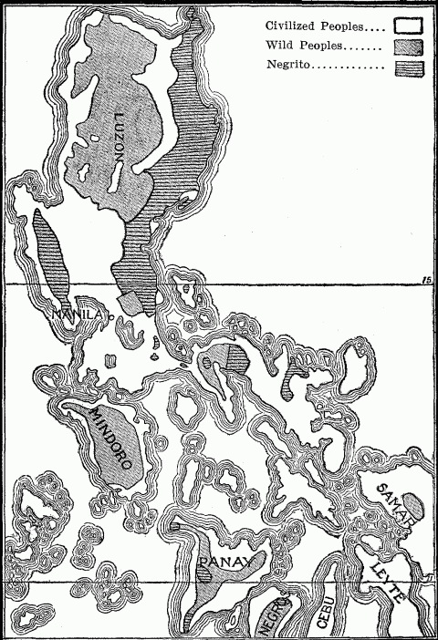
Philippine Islands. Distribution of Civilized and Wild Peoples
Dominant historical side.
The maritime periphery of a country receives a variety of oversea influences, blends and assimilates these to its own culture, Hellenizes, Americanizes or Japanizes them, as the case may be, and then passes them on into the interior. Here no one foreign influence prevails. On the land boundaries the case is different. Each inland frontier has to reckon with a different neighbor and its undiluted influence. A predominant central location means a succession of such neighbors, on all sides friction which may polish or rub sore. The distinction between a many-sided and a one-sided historical development depends upon the contact of a people with its neighbors. Consider the multiplicity of influences which have flowed in upon Austria from all sides. But not all such influences are similar in kind or in degree. The most powerful neighbor will chiefly determine on which boundary of a country its dominant historical processes are to work themselves out in a given epoch. Therefore, it is of supreme importance to the character of a peopled history on which side this most powerful neighbor is located. Russia had for several centuries such a neighbor in the Tartar hordes along its southeastern frontier, and therefore its history received an Asiatic stamp; so, too, did that of Austria and Hungary in the long resistance to Turkish invasion. All three states suffered in consequence a retardation of development on their western sides. After the turmoil on the Asiatic frontier had subsided, the great centers of European culture and commerce in Italy, Germany and the Baltic lands began to assert their powers of attraction. The young Roman Republic drew up its forces to face the threatening power of Carthage in the south, and thereby was forced into rapid maritime development; the Roman Empire faced north to meet the inroads of the barbarians, and thereby was drawn into inland expansion. All these instances show that a vital historical turning-point is reached in the development of every country, when the scene of its great historical happenings shifts from one side to another.
The Mediterranean side of Europe.
Change of historical front.
After the year 1492 inaugurated the Atlantic period of history, the western front of Europe superseded the Mediterranean side in the historical leadership of the continent. The Breton coast of France waked up, the southern seaboard dozed. The old centers in the Aegean and Adriatic became drowsy corners. The busy traffic of the Mediterranean was transferred to the open ocean, where, from Trafalger to Norway, the western states of Europe held the choice location on the world's new highway. Liverpool, Plymouth, Glasgow, Hamburg, Rotterdam, Antwerp, Cherbourg, Lisbon and Cadiz were shifted from shadowy margin to illuminated center, and became the foci of the new activity. Theirs was a new continental location, maintaining relations of trade and colonization with two hemispheres. Their neighbors were now found on the Atlantic shores of the Americas and the peripheral lands of Asia. These cities became the exponents of the intensity with which their respective states exploited the natural advantages of this location.
The experience of Germany was typical of the change of front. From the tenth to the middle of the sixteenth century, this heir of the old Roman Empire was drawn toward Italy by every tie of culture, commerce, and political ideal. This concentration of interest in its southern neighbor made it ignore a fact so important as the maritime development of the Hanse Towns, wherein lay the real promise of its future, the hope of its commercial and colonial expansion. The shifting of its historical center of gravity to the Atlantic seaboard therefore came late, further retarded by lack of national unity and national purposes. But the present wide circle of Germany's transoceanic commerce incident upon its recent industrial development, the phenomenal increase of its merchant marine, the growth of Hamburg and Bremen, the construction of ship canals to that short North Sea coast, and the enormous utilization of Dutch ports for German commerce, all point to the attraction of distant economic interests, even when meagerly supported by colonial possessions.
Location, therefore, while it is the most important single geographic factor, is at the same time the one most subject to the vicissitudes attending the anthropo-geographical evolution of the earth. Its value changes with the transfer of the seats of the higher civilizations from sub-tropical to temperate lands; from the margin of enclosed sea to the hem of the open ocean; from small, naturally defined territories to large, elastic areas; from mere periphery to a combination of periphery and interior, commanding at once the freedom of the sea and the resources of a wide hinterland.
Contrasted historical sides.
One-sided historical relations.
Scattered location due to geographic conditions.
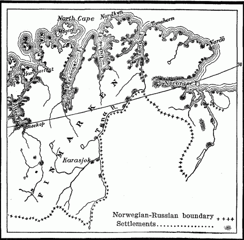
Distribution Of Settlement In The Norwegian Province Of Finmarken.
Island way station on maritime routes.
Not unlike this serial grouping of oasis states along caravan routes through the desert are the island way stations that rise out of the waste of the sea and are connected by the great maritime routes of trade. Such are the Portuguese Madeiras, Bissagos, and San Thomé on the line between Lisbon and Portuguese Loanda in West Africa; and their other series of the Madeiras, Cape Verde, and Fernando, which facilitated communication with Pernambuco when Brazil was a Portuguese colony. The classic example of this serial grouping is found in the line of islands, physical or political, which trace England's artery of communication with India—Gibraltar, Malta, Cyprus, Perim, Aden, Sokotra, and Ceylon, besides her dominant position at Suez.
Scattered location of primitive tribes.
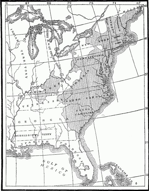
Distribution Of Population In The United States In 1800.
Ethnic islands of expansion.
Political islands of expansion.
The most exaggerated example of scattered political location existing to-day is found in the bizarre arrangement of European holdings on the west coast of Africa between the Senegal and Congo rivers. Here in each case a handful of governing whites is dropped down in the midst of a dark-skinned population in several districts along the coast. The six detached seaboard colonies of the French run back in the interior into a common French-owned hinterland formed by the Sahara and western Sudan, which since 1894 link the Guinea Coast colonies with French Algeria and Tunis; but the various British holdings have no territorial cohesion at any point, nor have the Spanish or Portuguese or German. The scattered location of these different European possessions is for the most part the expression of a young colonizing activity, developed in the past fifty years, and signalized by the vigorous intrusion of the French and Germans into the field. To the anthropo-geographer the map of western Africa presents the picture of a political situation wholly immature, even embryonic. The history of similar scattered outposts of political expansion in America, India and South Africa teaches us to look for extensive consolidation.
Ethnic islands of survival.
Discontinuous distribution.
Contrasted location.
Geographical polarity.
Each contrasted district has its own polarity; but with this it attracts not one but many of the disruptive forces which are pent up in every people or state. Certain conditions of climate, soil, and tillable area in the Southern States of the Union made slave labor remunerative, while opposite conditions in the North combined eventually to exclude it thence. Slave labor in the South brought with it in turn a whole train of social and economic consequences, notably the repulsion of foreign white immigration and the development of shiftless or wasteful industrial methods, which further sharpened the contrast between the two sections. The same contrast occurs in Italian territory between Sicily and Lombardy. Here location at the two extremities of the peninsula has involved a striking difference in ethnic infusions in the two districts, different historical careers owing to different vicinal grouping, and dissimilar geographic conditions. These effects operating together and attracting other minor elements of divergence, have conspired to emphasize the already strong contrast between northern and southern Italy.
Geographical marks of growth.
In geographical location can be read the signs of growth or decay. There are racial and national areas whose form is indicative of development, expansion, while others show the symptoms of decline. The growing people seize all the geographic advantages within their reach, whether lying inside their boundaries or beyond. In the latter case, they promptly extend their frontiers to include the object of their desire, as the young United States did in the case of the Mississippi River and the Gulf coast. European peoples, like the Russians in Asia, all strive to reach the sea; and when they have got there, they proceed to embrace as big a strip of coast as possible. Therefore the whole colonization movement of western and central Europe was in the earlier periods restricted to coasts, although not to such an excessive degree as that of the Phoenicians and Greeks. Their own maritime location had instructed them as to the value of seaboards, and at the same time made this form of expansion the simplest and easiest.
Marks of inland expansion.
On the other hand, that growing people which finds its coastward advance blocked, and is therefore restricted to landward expansion, seizes upon every natural feature that will aid its purpose. It utilizes every valley highway and navigable river, as the Russians did in the case of the Dnieper, Don, Volga, Kama and Northern Dwina in their radial expansion from the Muscovite center at Moscow, and as later they used the icy streams of Siberia in their progress toward the Pacific; or as the Americans in their trans-continental advance used the Ohio, Tennessee, the Great Lakes, and the Missouri. They reach out toward every mountain pass leading to some choice ultramontane highway. Bulges or projecting angles of their frontier indicate the path they plan to follow, and always include or aim at some natural feature which will facilitate their territorial growth. The acquisition of the province of Ticino in 1512 gave the Swiss Confederation a foothold upon Lake Maggiore, perhaps the most important waterway of northern Italy, and the possession of the Val Leventina, which now carries the St. Gotthard Railroad down to the plains of the Po. Every bulge of Russia's Asiatic frontier, whether in the Trans-Caucasus toward the Mesopotamian basin and the Persian Gulf, or up the Murghab and Tedjend rivers toward the gates of Herat, is directed at some mountain pass and an outlet seaward beyond.
If this process of growth bring a people to the borders of a desert, there they halt perhaps for a time, but only, as it were, to take breath for a stride across the sand to the nearest oasis. The ancient Egyptians advanced by a chain of oases—Siwa, Angila, Sella and Sokna, across the Libyan Desert to the Syrtis Minor. The Russians in the last twenty-five years have spread across the arid wastes of Turkestan by way of the fertile spots of Khiva, Bukhara and Merv to the irrigated slopes of the Hindu Kush and Tian Shan Mountains. The French extended the boundaries of Algiers southward into the desert to include the caravan routes focusing at the great oases of Twat and Tidekelt, years before their recent appropriation of the western Sahara.
Marks of decline.
Interpretation of scattered and marginal location.
The habits of a people and the consequent demands which they make upon their environment must be taken into account in judging whether or not a restricted geographical location is indicative of a retrograde process. The narrow marginal distribution of the Haida, Tlingit, and Tsimshean Indians on the islands and coastal strips of northwestern America means simply the selection of sites most congenial to those inveterate fisher tribes. The fact that the English in the vicinity of the Newfoundland Banks settled on a narrow rim of coast in order to exploit the fisheries, while the French peasants penetrated into the interior forests and farmlands of Canada, was no sign of territorial decline. English and French were both on the forward march, each in their own way. The scattered peripheral location of the Phoenician trading stations and later of the Greek colonies on the shores of the Mediterranean was the expression of the trading and maritime activity of those two peoples. Centuries later a similar distribution of Arab posts along the coast of East Africa, Madagascar and the western islands of the Sunda Archipelago indicated the great commercial expansion of the Mohammedan traders of Oman and Yemen. The lack came when this distribution, normal as a preliminary form, bore no fruit in the occupation of wide territorial bases. [See map page 251.]
Prevalence of ethnic islands of decline.
Contrast between ethnic islands of growth and decline.
Ethnic or political islands of decline can be distinguished from islands of expansion by various marks. When survivals of an inferior people, they are generally characterized by inaccessible or unfavorable geographic location. When remnants of former large colonial possessions of modern civilized nations, they are characterized by good or even excellent location, but lack a big compact territory nearby to which they stand in the relation of outpost. Such are the Portuguese fragments on the west coast of India at Goa, Damaon, and Diu Island, and the Portuguese half of the island of Timor with the islet of Kambing in the East Indies. Such also are the remnants of the French empire in India, founded by the genius of François Dupleix, which are located on the seaboard at Chandarnagar, Carical, Pondicherry, Yanaon and Mahe. They tell the geographer a far different story from that of the small detached French holding of Kwang-chan Bay and Nao-chan Island on the southern coast of China, which are outposts of the vigorous French colony of Tongking.
The scattered islands of an intrusive people, bent upon conquest or colonization, are distinguished by a choice of sites favorable to growth and consolidation, and by the rapid extension of their boundaries until that consolidation is achieved; while the people themselves give signs of the rapid differentiation incident to adaptation to a new environment.
NOTES TO CHAPTER V