Chapter VIII · FROM MUSH TO ERZERUM
Reading edition
It was the 29th of November, just after half-past nine in the morning, when our party of four Europeans and four Turkish soldiers defiled into the plain from the hill of Mush. The iron-grey colt was being led by one of our new companions, the more docile that he anticipated release. Were we prisoners and these our jailers? I asked the question of the principal man, who was a sergeant with the name of Mevlud Chaoush. A black shawl, reaching to the shoulders, was wound about his head as a protection from the weather. His irregular and forbidding features never broke into a smile, nor did his lips move except to utter a command. We passed several deserted burying fields, with fallen headstones, and forded the Garni Chai, a mere torrent in a wide bed. More than half-an-hour had passed before we doubled the western promontory, and struck our true course across the plain.
We skirted or could see several hamlets—dots in the expanse, which had the appearance, usual in this country, of a sea. No hedges or artificial boundaries parcel the ground; no leafy trees blend in the distance to a soft, grey mass. The harvest had been gathered, and you could scarcely tell the difference between the cultivated and the unreclaimed soil. Marshes, instead of a network of irrigation channels, received the waters babbling down from the southern range. After several halts, rendered necessary by the freaks and misfortunes of the baggage horse, we reached at half-past twelve the considerable Armenian village of Sheikh Alan, near the ford of the Murad. About a mile beyond the village we approached the margin of the noble river which we had followed from Karakilisa to Tutakh.
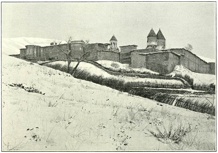
Fig. 155. Monastery of Surb Karapet from the South.
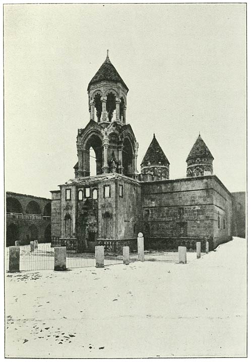
Fig. 156. Church of Surb Karapet from South-West.
A walled enclosure, like that of a fortress, a massive door on grating hinges—such is your first impression of this lonely fane (Fig. 155). My illustration shows the long line of monastic buildings on the south; the gateway is on the west. You enter a spacious court, and face a handsome belfry and porch, the façade inlaid with slabs of white marble with bas-reliefs (Fig. 156). We were conducted to a long chamber, with walls of prodigious thickness, recalling our Norman refectories. It was nearly six o’clock; the monks received us without surprise, and had probably been forewarned by the Mutesarrif. When I asked for a separate room, it was pleaded that none was vacant; and the preparations of Mevlud to sleep by our side in the long chamber convinced me that resistance would as yet be vain. With the best humour we joined in a meal of extreme frugality, which was spread upon trays and partaken of by all the monks. Of these there were six in residence and six absent, one being confined in a Turkish prison. Four deacons were also of the company; but conversation was difficult in the presence of the silent Mevlud. Our hosts were superior people, judged by the standards in this country; and after supper, over the glow of a number of braziers, we were drawn together by common sympathies. In particular I was attracted to a well-read monk of quiet demeanour, whose personality and name I hesitate to disclose.
The morning broke serene and clear; a brilliant sun embraced the landscape which from the terrace outside the walls, where is situated a little cemetery, was outspread at our feet (Fig. 157). The eye sank to the floor of the plain or was lifted to the summits of the mountains, which were seen in all the variety of their many forms and myriad facets above beds of vapour, clinging captive to the middle slopes. This sea of clouds concealed the river where it issues from the expanse to be buried in the amphitheatre of heights. But my companion, the mild-tempered monk, told me they could sometimes hear from this terrace the hissing of the waters as they enter the passage. They call the place Gurgur, a name imitative of the sound which, when the air is heavy with cloud towards the end of winter, is loud and long-maintained. Then they say that spring is near at hand. He added that the ruins of an Armenian fortress may still be seen within the gorge. Its ancient name was Haykaberd.
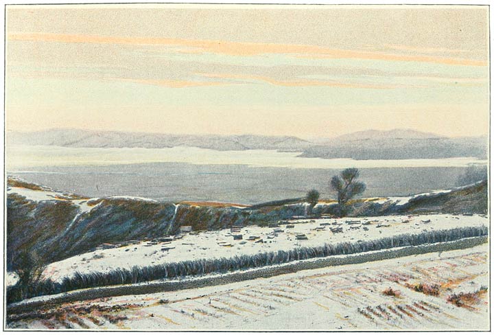
Fig. 157. View south from the Terrace at Surb Karapet.
What with the Kurds and the suspicions of the Turkish Government this once flourishing monastery has been stripped of much of its glamour; indeed the monks are little better than prisoners of State. The new buildings on the west, erected by Bishop Mampre, have never yet been used. They were destined to receive the printing press, and the relics of the library. But the printing press—the wings of knowledge, said my companion—was placed under the ban of Government as early as in 1874. The library was pillaged by Kurds during the first half of the present century, and its contents burnt or littered about the courts. Nor is it possible for the community to pursue their studies, since any book which deals with the history of their nation is confiscated by the authorities. I think I have already mentioned that the same officials seize and burn our Milton and our Shakespeare. And yet the ambassadors of Europe dally on the Bosphorus, powerless to redress these wrongs and avenge these insults. It is because in Russia they practise similar iniquities, and because Europe stoops to sit at Russia’s feet. Upon such matters we conversed when the air was a little clearer, after a fierce encounter between Mevlud and myself. That sinister personage had presumed to accompany me to my host’s room; but I peremptorily ordered him out. I told him that if he ventured to invade the privacy of a priest’s apartment I would undertake to have both the Mutesarrif and himself dismissed.
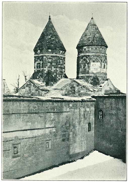
Fig. 158. The Two Chapels at Surb Karapet.
Because the pass is no pass in the ordinary sense; it is merely the edge of a tableland. Mile after mile towards the north stretched the undulating snow-field, swept by the winds, pierced by spinous blades of grass. We stood at an elevation of nearly 8000 feet. Below us, infinitely deep, lay the magnificent plain of Mush, bounded on the further side by the barrier of the Kurdish mountains, crossing the landscape from the invisible waters of Lake Van. In one continuous wall they swept across the horizon, serrated, sharply chiselled above the deep valleys opening transverse to the line of the wall. Taurus they call the range, adopting a nomenclature which the West must have borrowed from the East. Taurus was very high where the Murad dives into the mountains; nor did the peaks appear less lofty on its right bank. We saw them circling towards the river from behind the plateau upon which we stood; but I was unable to trace the origin of this northern chain. It formed a marked exception to the outlines north of Taurus, which were vaulted or horizontal. Nimrud was seen to join the two contrasting landscapes, placed across the head of the plain. The neighbouring Kerkür looked more rounded than when we had first observed it, while, north of the Nimrud caldron, the swelling contours of the Sipan fabric were doubly soft in a robe of recent snow.
The village or little town—for it is the capital of a caza, the caza of Varto, belonging to the sanjak of Mush—is situated in the long valley of which I have been speaking, between the Bingöl and the block of mountain on the north of Mush. A small river flows below it at some little distance, which joins the Bingöl Su some two or three miles south of the town. The united waters issue into the Murad or Eastern Euphrates about eight miles south-east of Gumgum. The direct road to Mush is taken along the Murad, which, after the confluence, finds a passage through the hills. It reaches the plain at the village of Sikava.
We were received by the Kaimakam, who lodged us in his room of audience, a chamber of which the stone walls were daubed with whitewash, while the massive logs of the ceiling were left bare. A single window, with panes of greased paper, diffused a dim light by day. A little lamp revealed the burly figure of our host, seated on the divan. Beside him, but in shadow, we might just discern a face and features which were recognised as familiar to us. We identified this pleasant countenance and chiselled lineaments with those of the silent chess-player at Mush. It was in fact the Hakim Effendi, learned in the law; though for what purpose he had travelled to these unruly wilds we were unable to ascertain. He had brought his law books with him in a khurjin, or little saddle-bag, which was placed by his side on the couch. So he travels from place to place, the name and shadow of a dispensation which he has not the power to enforce. Even under the eyes of the Kaimakam cases of theft, and even of robbery, are of daily occurrence and go for the most part unredressed. Entering the stable allotted to our horses, I was met by an Armenian woman, a poor old hag with bare feet and in rags. She moaned and wrung her hands, explaining, in answer to my enquiry, that her cows had been displaced to make room for us. She would never see them again—and, in fact, next morning I was grieved to learn that two had been stolen.
The town occupies a fairly high site in the valley, having an elevation of about 4800 feet. A few houses, in the more proper sense of the word, serve to magnify the appearance of the place. But the tenements are for the most part the usual ant-hill burrows; and I do not think that in all there can be more than eighty dwellings, of which ten may be inhabited by Armenians. The Kurds have a large preponderance in the caza; they are, for the most part, of the Jibranli tribe. This tribe furnishes three regiments of Hamidiyeh cavalry, recruited in Varto. The tribesmen spend the summer on the pastures of the Bingöl Dagh, and the winter in villages of their own in the plains. They travel as far as Diarbekr, and even Aleppo, taking their vast flocks to those markets. Or they sell the sheep to middlemen who travel from all parts of Turkey, and establish their headquarters in Khinis.
During the night it froze hard; but on the following morning the air was warmed by a brilliant sun, shining in a clear sky. The thermometer stood at 37° before we again set out. Leaving at a little after eleven, we proceeded on an easterly course, towards the heights which rise behind Gumgum. I was unable to ascertain the exact connection of these hills with the block of the Bingöl; but, whereas we could still perceive that distant outline in the west, it was lost to view as it came towards us, stretching east. The northern barrier was now composed by the hill range already mentioned, which, at this point, appeared to be inclined towards south-east. After crossing a considerable stream, flowing down to the trough of the valley, we commenced at twelve o’clock the ascent of these hills.
Looking backward, one was impressed by the uneven character of the ground from which we rose. The valley is choked with hills, especially on the south-east, and it may have a width of about eight miles. The soil is covered with tufted grass, which must afford fine pasture in spring and early summer. The southern border consists of the mass of mountain which we had crossed from Changalli; but it had sensibly declined and was still declining in height. Beyond its sheet of snow the peaks of Taurus commenced to be visible; and when we reached the pass, before one o’clock, we could see the broad ribbon of the Murad lying in the plain of Mush. The river had passed the gap in the barrier on the north of that plain, which, it was evident, becomes much lower at the point where the passage is effected, the outlines sinking towards either bank.
We were standing in snow, at an elevation of 6600 feet. On our left front rose the cliffs of the Bingöl plateau, that mighty presence which for awhile had been concealed. They were still stretching from west to east, but were seen to turn towards north-east, in the direction of where we knew Khinis to lie. The eye pursued their long perspective into the distance, where, at a point about north-north-east, they broke away into a range of mountains, the range which bounds the plain of Khinis on the north. I was still unable to define the relation of the heights upon which we were placed to the mass from which they appeared to come; but they must contribute to compose the long line of heights which we had seen extending from the Bingöl towards Sipan.
At a quarter-past three we were again in the saddle. Our course remained easterly, at about the same level; and at half-past three we were on the top of one of those bulging spurs which project from the side of the cliffs. The horizontal edge of the lofty tableland was now just above us; and, inasmuch as we were now able to pursue a north-north-easterly direction, it is evident that the mass must recede towards the north. Indeed it is probable that it describes a curve, concave to the plain of Khinis; we seemed to get behind the cliffs. On our right hand we were followed by the deformed shape of Khamur, now many miles away. The horizon was fretted by the long outline of the Akh Dagh—a fine, bold range with connections circling towards Khamur.
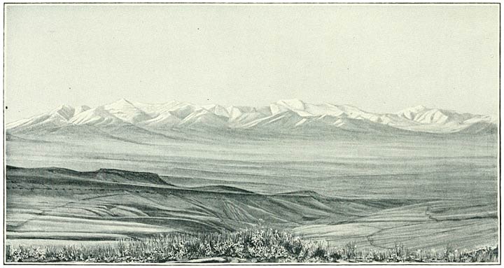
Fig. 159. The Akh Dagh and the Plain of Khinis from the South.
By directions of the Kaimakam we were lodged in his own office; he made his appearance early on the following day. A burly old man, with a head of great size and a massive forehead, with huge dimensions below the waist. This habit of body, which seemed to aggravate an advanced asthmatic affection, was due to continued sitting rather than to intemperance of diet. Our conversation was soon directed to the condition of the country—a subject upon which he held strong views. The people of his caza were, he said, almost without exception, liars, rogues and thieves. The Government did what it could; but the officials were not competent, being ignorant men like his humble self. Schools? There was supposed to be a Rushdiyeh in Khinis, but it was a Rushdiyeh only in name. As for the Kurds, they were the plague of his existence; you reaped them where you had not sown. Five houses here, there fifty people—impossible to count or to bring to count. If you wished to get anything out of them, you must borrow a stick from a bear-tamer and beat them about the head.
He proceeded to inform me that the town was the principal centre of the trade in sheep, fattened upon the pastures of the Bingöl Dagh. Merchants come from the great cities, notably from Damascus, and make their arrangements in Erzerum. They bring their own shepherds, whom they send to Khinis when their agents there have concluded the purchase and received the flocks. It is at about the present season—that of early winter—that the trade is at its height. The sheep are driven across the mountains to Diarbekr, whence they are despatched through the plains to the Syrian centre. My host added that it was no very easy matter to get them safely through the snow to the head of the Mesopotamian plains. To me it seems a most remarkable feat.
He knew of no Yezidis within the limits of his district; but gypsies wander through it in summer. Of Kizilbash Kurds he believed there to be about fifteen villages. The principal tribes in the neighbourhood are the Haideranli and Zirkanli, besides about eight villages of Jibranli Kurds. Four battalions of Hamidiyeh are said to be enrolled in the caza.
The day was fine, with a warm sun and a blue sky; the air was fresh and strong. Before us, and on every side, stretched the undulating surface, of rich and friable brown loam. It is subjected to primitive methods of cultivation; but at this season it was difficult to trace the hand of man. We saw no villages; what there are must be hidden in laps of the ground; and Nature, a kind and bountiful Nature, is allowed to revolve her seasons almost in vain. Bright streams come bubbling down from the distant framework of mountains, and wind on a south-easterly course to the far Murad. We passed no less than three of these tributaries to the river of Khinis. The first was flowing between high banks of volcanic rock, and sheltered a beautiful church in the old Armenian style, called Kilisa Deresi, or the church in the valley. Around this monument were grouped the tall headstones of a disused cemetery, some engraved with the elaborate crosses which were so dear to the ancestors of the unhappy people, now the bondsmen of parasite Kurds. Even as we stood in admiration of this charming building, an active Kurd in a showy dress stepped into the path. He vaulted upon the back of a graceful chestnut Arab, which was being led to and fro. We saw him cantering off to the neighbouring Armenian village, and we wondered upon what errand he was bent. At a quarter-past one we commenced to ascend to a passage of the hills which confine the plain upon the north.
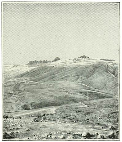
Fig. 160. Terrace of Lava resembling Human Fortifications.
In the space of half-an-hour we had reached an elevation of over 6000 feet. We stopped for some little time to fully realise the scene which we were now about to leave behind. The terraces of the Bingöl plateau had been following our steps at some distance on our left hand. We had come in a northerly direction from Khinis; and the heights we were preparing to cross were an immediate spur from that table surface, linking it to the long range on the north of the plain. Both that spur, or connecting ridge, and the range which it joined, tended to incline south-west from a latitudinal course. The plateau itself was now close up; indeed it rose immediately above us, on the west of our winding track. It is therefore plain that it must have pursued a north-north-easterly direction, since it had formed a distant background to the town. I turned the camera upon the flanking ridge (Fig. 160), and then mounted to an adjacent eminence, almost on a level with the surface of the plateau. My illustration shows a formation characteristic of the edge of the terraces, great blocks of stone welded together as if by a human hand. The surface is flat and is covered with rough grass, of which the higher stalks pierced the covering of recent snow.
So little interest is taken by the people in their surroundings that even the Kaimakam was unable to tell me the name of this adjacent range, which forms a lofty barrier to the plain. He was of opinion that it was called the Akh Dagh (white mountain) or Tekman Dagh; to some it was known as the Kozli Dagh. I prefer to retain the name which I heard the most often, that of Akh Dagh. East of these linking hills it assumes lofty proportions; but it appears to die away in the remote south-east.
In the south, far away, rose the mass of Khamur, with hill ranges circling round the plain. Above those humble outlines was revealed the whole fabric of Sipan, some seventy miles distant from where we stood. Such is the extension of these vast depressions; you cannot define their limit; they render easy the traffic of peace or the passage of war. And we may reconstruct in fancy the remote period, when many of these bold landmarks were wreathed in smoke and reflected fires, and thundered with the energy of the Globe.
Proceeding at two o’clock, we reached the pass in twenty minutes; it is just under 7000 feet. We were now in the basin of the Upper Araxes, approaching the districts on the north. The passage into a new sphere could scarcely have been accentuated with more emphasis than on this day. We dived into a dense fog; the cold was intense; and, whereas not a single flake had hitherto lain on the track, it was now all strewn with snow. Nor was the change of a merely local application; it was the commencement of a new order of things.
We rode on a northerly course through beds of vapour over lofty uplands at an elevation of more than 6000 feet. The track had been worn by traffic, tracing upon the snow-fields winding furrows of rich brown soil. A Kurdish village was passed, where our zaptiehs changed with others; and, a little later, we overlooked a considerable depression of the surface—the wide valley of a river it appeared to be. It was clothed with snow and wreathed with mist. We descended into this valley, said to belong to the district of Tekman, and crossed the river, called the Bingöl or Pasin Su. It was flowing due north, and had a breadth of about 15 yards. On the opposite margin of the depression is placed the Kurdish village of Kulli, where we arrived at a quarter-past four. It is situated at a level of about 6000 feet; and, whereas at Khinis (5540 feet) we had enjoyed a temperature of 32° at 10 P.M., the thermometer now registered at 7 P.M. no less than 7° of frost (Fahrenheit).
Next morning before eight we continued our journey, the temperature registering 14° of frost. Mist still hung over the valley; but we soon were raised above it, again ascending to the table surface which borders the depression on either side. Full sunlight streamed upon the undulating snow-field, and was reflected in tiny rays from a thousand little crystals, placed, like diamonds, on the heads of encrusted flowers. It was, indeed, over the face of an immense block of elevated country that our course was directed for some little time. Here and there, especially in the north, it appeared to be broken by chains of mountain; but the closer you approached such an apparent barrier, the more it assumed the familiar features—the flat edges, and the fanciful castles with their Cyclopean walls. At half-past nine we obtained a view of the Bingöl Dagh itself, in the furthest horizon of the south (Fig. 161). We stood at a level of 7130 feet.
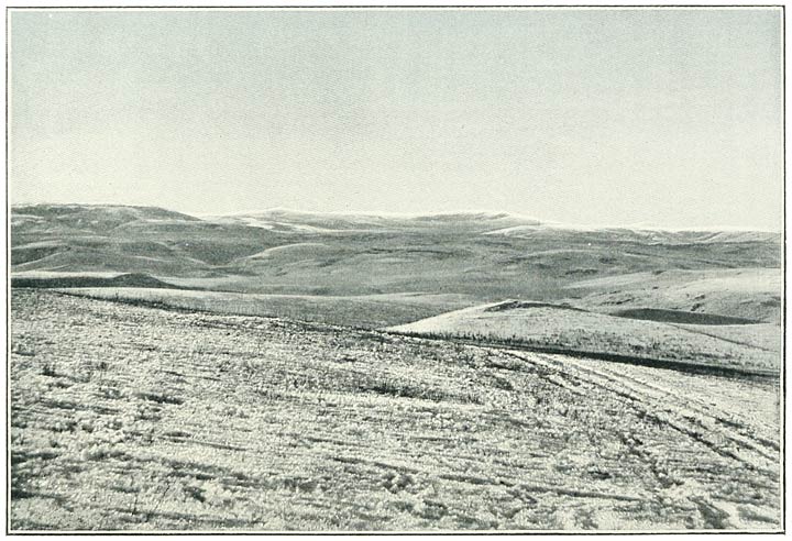
Fig. 161. The Central Tableland, Bingöl in the distance, from near Kulli.
At ten o’clock we turned off eastwards to the bed of mist suspended above the river, which lies in a deep trough. Following for awhile along the sides of the lofty cliffs which confine it, we admired the play of the vapours, wreathing like jets of steam. From the edge of the cliffs on either bank, the table surface of the higher levels was seen to stretch east and west, and back to the peaks of the Akh Dagh—a sheet of snow, only broken by the gorge. The Bingöl Su was pursuing a north-north-easterly direction, which became more northerly as we progressed. The fog lifted and disappeared; we descended into the bottom of the gulf, which opened on either side the further we rode. At a quarter to twelve we arrived in the Kurdish hamlet of Mejitli, where we decided to make our mid-day halt. We had come a distance of about 13 miles from Kulli. The river, which had a breadth of about 20 or 30 yards, was flowing some 50 feet below the village, with a rapid current, flashing over the rocks. The site of the village is a little plain on the left bank of the stream having an elevation of about 5800 feet.
It has already been said that the valley of the Bingöl Su, or Upper Araxes, offers an easy approach to the districts on the north. The river pierces a wintry region of the table surface, and traffic is carried along its bed. But some 2½ miles below the village of Mejitli it enters a deep and impassable gorge. You mount to the summit of the lofty precipices which overtower its serpentine course. Again in the saddle at half-past one, we reached this commanding eminence at a quarter-past two. Nor did we descend afresh into the trough of the stream, which proceeded to thread a chaos of mountains in the east.
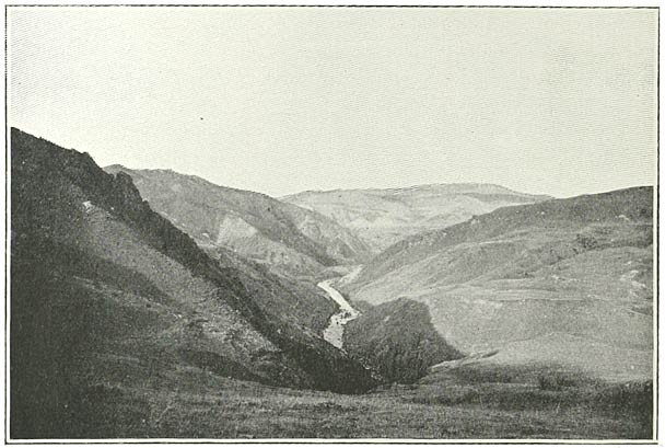
Fig. 162. Looking down the Valley of the Upper Araxes from below Mejitli.
The view from any point was one of savage beauty (Fig. 162). By slow degrees the flat surface of the elevated plateau was becoming riven and broken up. You could still discern the level snow-fields, burying the stream in the south, and coming towards you on either bank. But the cloak of winter had not yet hidden the yellow grass on the adjacent slopes; while in the east the scene was changing to a wild landscape of hill and mountain, upon which the snow had not yet effected a hold. A few miles further these features increased in definition. The layers of lava gave place to hard limestones, forming peaks which had weathered a soft white. Masses of rock, of a hue which was green as the rust of copper, or red like that of iron, were exposed on the sides of the hills. From a foreground of tufted herbage, sown with yellow immortelles, we looked across this troubled region in which the river wound its way—a ribbon of changing colours, skirting the foot of sweeping hillsides or confined in narrow clefts of stupendous depth. In the far east we caught a glimpse of the snowy dome of the Kuseh Dagh, which overlooks the plain of Alashkert.
At four o’clock the track diverged, and led us over the undulating plateau which still continued, but with less regularity, in the west. A short turn towards north-west brought us almost to the threshold of the broad depression of Pasin. The ground fell away by a succession of convexities to a level surface, deeply seated at our feet (Fig. 163). But far in the north, on its opposite margin, again appeared the cliffs of a plateau, exalted thousands of feet above the plain. It represents the extreme extension of the tablelands of Armenia, to be succeeded by the peripheral ranges in the north. It was carried west and east, across the horizon. In this neighbourhood it is known as Kargabazar.
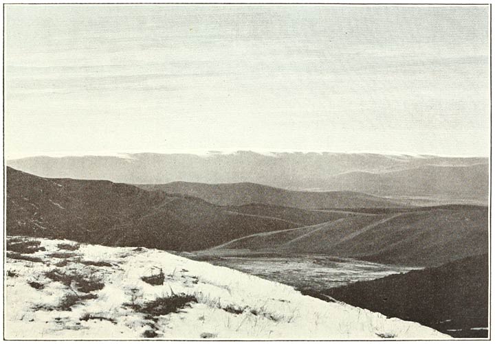
Fig. 163. Kargabazar, across the Plain of Pasin, from the southern margin of the Central Tableland.
We descended into one of the long valleys by which the heights we were leaving meet the plain. If Erzerum be the next objective, you cross to its western side and proceed by way of Ertev. Our own point was Hasan Kala, a more northerly course, leading through the village of Ketivan. That considerable Mohammedan settlement is situated at the end of the valley, whence you issue upon the spacious expanse. We rode at a rapid trot from this southern verge of the plain to the opposite margin, upon which is placed the castle and town. It formed a welcome landmark, which we reached in just an hour, arriving beneath the dusk at half-past six.
We slept in an inner room of this clean little tavern, and resumed our journey at eleven o’clock on the following day. The streets were alive with people, a motley band of human beings—for Hasan Kala, with its warm baths and numerous khans and shops, lies on the main road to Tabriz. It is lifted a little above the face of the plain and has an elevation of about 5600 feet. You look back upon its crumbling walls with a certain sympathy for its fallen greatness, and wonder whether it will again rise, like Kars, from its fallen station under a further advance of the Russian Empire towards the Mediterranean. Behind this deserted fortress—which, nevertheless, I was forbidden to photograph—we admired the huge bulwark of the mountain barrier, mocking the works of man. There was the same flat edge, which had so often excited our wonder, to those formidable cliffs. East and west, in a long and horizontal outline, they were drawn beyond the range of sight. The corresponding features on the south of the plain were less emphasised, the long valleys softening the abruptness of the higher ground.
Pasin—the reader may remember—is one of the principal links of the chain of depressions which connect the extremities of western Asia, and facilitate intercourse between east and west. From the narrows of Khorasan to the fantastic parapet of the Deveh Boyun, it has a length of no less than forty-four miles. Our way to Erzerum led us along this spacious avenue, and, after crossing the humble barrier which I have just mentioned, debouched upon the city on the opposite side. We were able to ride at leisure, along a course direct as an arrow, free to observe the stream of traffic on the highway.
An element of special interest were a number of bullock-carts, laden pell-mell with heaps of Hamidiyeh uniforms, destined for the rank and file. They slowly made their way towards Hasan Kala, groaning and creaking as they went. Long strings of Bactrian camels—huge, large-humped, shaggy animals—defiled with a lulling symmetry of movement and measured, noiseless tread. By their side walked the drivers, Tartars with skins of parchment, their features scarcely visible beneath their sheepskin caps. Of wayfarers there were many, and of the most divergent types. Some were mounted on little hacks, here and there a whole family—turbaned Mussulmans, astride of their overhanging mattresses, to which were attached a jangling cluster of cooking pots. A led horse would be encumbered by a still more formless bundle, which, as you approached, displayed a pair of human feet. Brawny Armenian peasants, a scattering of thick-set Lazes, a Kurdish horseman or two swelled the throng.
Approaching closer, the road is seen to find a passage between the hills on the south and the adjacent flat-topped mass. The width of this passage may be about half-a-mile. Once within the answering horns you cross a spacious amphitheatre, in which the secret of the formation is revealed. The two hills belong to the southern wall of mountain, but so also does the mound. And a line of heights circle inwards from behind the two hills, to protract the circle outwards to the horn of the mound. Hills and mound are left behind before those heights are breasted; or, to continue the figure, you scale the tiers of the amphitheatre at the point most remote from the narrow opening on its eastern side.
Such is the position which, due not to man, but to a freak of Nature, arrests the flow of traffic or the tide of battle. The linking heights—the opposite curve of the circle—are widely known through the literature of travel and of Asiatic warfare as the Deveh Boyun, or the camel’s neck. The humps and head are represented, the first by the two hills, and the second by the mound. The pass, to which the road climbs, is situated on the neck of the camel; but a second ridge must be surmounted, which is a little higher, and has an elevation of about 6850 feet.
Mush–Surb Karapet 25 miles
Surb Karapet–Gumgum 28½ miles ,,
Gumgum–Khinis 24 miles ,,
Khinis–Kulli 23½ miles ,,
Kulli–Mejitli 13 miles ,,
Mejitli–Hasan Kala 22½ miles ,,
Hasan Kala–Erzerum 23 miles ,,
Total 159½ miles.
↑