PART I.—PARIS TO MARSEILLES. (continued 3)
Reading edition
49 m. N. from Lunel by rail is Vigan. (See page 105.)
96½ m. W. from Marseilles, 43 m. W. from Arles, 31 m. S.W. from Nîmes, and 15 m. S.W. from Lunel, is
Montpellier.
MONTPELLIER, on the sides and summit of an eminence 145 ft. above the sea and 7 miles from it. Pop. 56,000. Hotels: H. Nevet, the best and most expensive, at the commencement of the Esplanade. On the same side, only a little farther up, is a block of handsome buildings containing the Public Library, closed on Sundays and Thursdays, and the Picture Gallery or Musée Fabre, open on Sundays and Mondays. Adjoining is the Lycée.
In the Place de la Comédie, near the Esplanade, is the H. du Midi, the next best hotel. In the Grande Rue, the H. Cheval Blanc, frequented by commercial men. Opposite the station is the H. de la Gare. In the fine broad street, the Rue Maguelone, leading from the
Temple Protestant near station, in the Rue Maguelone. Telegraph Office in the Boulevard de la Comédie. Post in the Boulevard Jeu-de-Paume. From the Esplanade omnibus runs to Castelnau. From near the Place de la Comédie coach to Mauguio. From the Boulevard de Blanquerie, below the prison, coach to Claret and St. Hippolyte. (See map, p. 66.)
Montpellier: Botanic Gardens.
The most modern part of the town is the Rue Maguelone, leading from the station to the Esplanade, a delightful promenade bounded by the citadel. At the N.W. angle of the Esplanade a stair leads down to a line of boulevards, passing up by the “Hôpital Général” to the Botanic Gardens, the earliest institution of this kind in France, founded in the reign of Henri IV., and for some years under the direction of the famous botanist De Candolle. It contains an area of 9 acres, divided into three parts: at the N. end is a nursery; at the S., in a hollow, surrounded by trees, the botanical part; and between these two divisions the arboretum. Opposite the Botanic Gardens is the once famous École de médecine, said to have been founded by Arab physicians under the patronage of the Counts of Montpellier. It now occupies the old bishops’ palace, built in the 14th cent., with additions in the 17th. At the entrance are bronze statues of Barthez, 1734-1806, and La Peyronie, 1678-1747. Within the entrance are busts of the most celebrated professors and divines connected with the college and the church of Montpellier. In the same building are also valuable anatomical and pathological collections, and a library with 55,000 vols. Adjoining is the Cathedral of St. Pierre, 14th and 15th cents., but the choir is recent, though in the same style. White marble statue of Mary and child by Canova.
Overlooking the Botanic Gardens is the beautiful promenade, the Place du Peyrou, on an eminence at the western side of the town. In cold weather invalids and nurses with their children frequent the lower terrace of this “Place,” the promenade Basse du Midi. At the western end of the Peyrou is the Château d’Eau, a hexagonal Corinthian building, which receives and distributes through the town the water brought from the fontaine de St. Clement, 5½ m. from Montpellier. The aqueduct, which conveys the water across the valley from the opposite hill, consists of two tiers of arches 70 ft. high and 2896 ft. long. The gate at the end of the promenade was erected to commemorate the victories of Louis XIV. Adjoining is the Palais de Justice, with statues of Cambacérès and Cardinal Fleury. Eastwards, by crooked streets, are the Mairie and the markets.
Montpellier: Musée Fabre.
A short way north from the Hôtel Nevet, by the Rues Ste. Foi and also on the Esplanade, is a handsome modern edifice, comprising the Musée Fabre, the Bibliothèque publique with 65,000 vols., and the “Collection de la Société archéologique.” The Musée Fabre, open on Sundays and Mondays and feast days, contains, among many works of inferior merit, some good pictures by great artists, such as Berghem,
Montpellier produces a lovely coloured wine with good bouquet, called St. Georges d’Orgues. The manufacture of verdigris, the preparation of preserved fruits, dye works, chemical works, and distilleries, are the principal industries.
From the railway station, opposite the Hôtel de Nevet, a line extends through the lagoon Pérols, covering a surface of 3000 acres, and yielding annually 2000 tons of salt, to the port of Palavas, 5 m. south (pop. 1000), with a beautiful beach. At the Palavas terminus is the Casino hotel, and on the Canal the Hôtel des Bains and the Restaurant Parisien. A cabine (bathing-house), including costume and linen, costs 1 fr. Leave the train at the Plage station. 3 m. from Montpellier, in the retired valley of the Mosson, is the mineral water establishment of Foncaude. Water saline, unctuous, and sedative. Good for indigestion and nervous disorders. 12½ m. north from Montpellier is the Pic du Loup, rising from the village St. Mathieu (pop. 500) to the height of 680 ft., commanding an extensive view, and having on the top a chapel visited by pilgrims.
From Montpellier a line extends 43½ m. W. to Faugères on the line from Beziers to Capdenac by Rodez. (See map, page 27.)
Frontignan. Cette.
109½ m. from Marseilles and 4½ from Cette is Frontignan, pop. 3000. Possessing 570 acres of vineyards producing rich amber-coloured, luscious, and spirituous wines, made principally from the clairette and picardan grapes. The neighbouring marshes yield annually about 50,000 tons of salt.
114 m. from Marseilles is Cette, pop. 29,000. At this point the Chemins de Fer de Paris à Lyon system joins the Chemins de Fer du Midi, and consequently carriages are often changed here. For Cette to Toulouse and Bordeaux, see Table “Bordeaux à Cette” in the “Indicateur des Chemins de Fer du Midi.” Cette is 271 m. east from Pau, 266 from Bordeaux, and 84 from Perpignan. Omnibuses and coaches await passengers. Hotels: Barrillon; Grand Galion; Bains; Souche. Cette makes a pleasant halting-place. The best walk is to the top of Mt. Setius, 590 ft. Ascend by the Rue d’Esplanade, and when at the highest part of the Public Gardens take the road to the right. The view is magnificent. In front is the Mediterranean, and behind Lake Thau with its villages. At the base of the mountain is Cette, and beyond Frontignan. The Port of Cette is protected by a breakwater 548 yds. long, which encloses a harbour of 210 acres, furnished with two jetties; the western, constructed by Vauban, is 656 yds. long, and the eastern 548 yds. This busy port, besides having an extensive carrying trade, has a large wine manufactory, where above 100,000 pipes of imitations of all the well-known wines are made annually, by mixing different wines with each other.
From the first bridge over the canal (not including the railway bridge) a small steamer starts three times daily for Balaruc and Meze, on Lake Thau. Meze, like Cette, is entirely devoted to the wine trade. Balaruc has a bathing establishment, supplied by intensely saline springs, resembling strong sea-water, temperature 125° Fahr. A quart contains 106 grains of chloride of sodium, 13½ of the chloride of magnesia, and a fraction of the chloride of copper, 15 grains of the sulphate, and 13½ of the bicarbonate of lime. Pension, 8 to 9 fr., and the bath treatment 4½ fr. additional. The Canal du Midi enters Lake Thau at Les Onglous, 11 m. W. from Cette. (See map, page 27.)
Miramas. Port Bouc.
PARIS MARSEILLES 503 34 MIRAMAS, pop. 900, south from the station at the head of the Étang Chamas. At the station there are a small inn and a large plantation of almond trees, which, when in flower, exhale a delightful perfume. Passengers to Avignon by Cavaillon and L’Isle change carriages here (p. 65). Also for Port Bouc, 16¼ m. south.
MIRAMAS TO PORT BOUC.
Miramas to Port Bouc by rail through a flat plain (see map, p. 66). The two most important towns passed on the way are: Istres, 6¼ m. from Miramas station and 10 N. from Port Bouc, pop. 4000, founded in the 8th cent. on Lake Olivier, and possessing still part of its ancient ramparts. The principal industry is the manufacture of salt and of the carbonate of soda. 13¼ m. from Miramas is Fos (Fossae Marianae), pop. 1100, on a hill crowned with the ruins of a castle, 14th cent. At the foot of the hill, by the side of the Arles canal, are large tanks for the manufacture of salt. From Fos, other 3 miles south by rail, or 16¼ miles altogether from the Miramas railway station, or 29 miles S. from Arles by the canal, is Port Bouc, pop. 1000. Inns: near the stations of the railway and the canal steamer, the Hôtel du Commerce; near the jetty, the Hôtel du Nord. Port Bouc, on the Étang Caroute, near the entrance to the great lake, the Étang de Berre, is an important fishing-station with a large and well-protected harbour. At the end of the jetty is a fixed light, seen within a radius of 10 m. At the other side of the entrance is Fort Bouc with a massive square tower in the centre and another lighthouse. About 7 miles west from Port Bouc by the coast road is the Port of St. Louis, page 72. (For Port Bouc to Martigues and Marseilles, see p. 118.)
Port Bouc to Arles, 29 m. S. by the canal steamboat; time, 5 hrs; fare, 3 frs. The canal is 62 ft. wide and 8 deep. The embankments are very solid, and along a great part of them extends the railway between Arles and Saint Louis. The only town the canal passes is Fos, about ½ m. E. The Miramas railway passes it on the other side. Passengers drop into the steamer from the farmhouses. The steamer moors at the S.W. corner of Arles. (See p. 72, and map p. 66.)
Saint Chamas. Rognac.
PARIS MARSEILLES 506½ 30½ SAINT CHAMAS (Sanctus Amantius), pop. 3000, about ½ m. Lake Berre, a sheet of water 14 m. long and 38 in circumference.
PARIS MARSEILLES 519½ 17½ ROGNAC, pop. 900. Junction with rail to Aix, 16½ m. E., passing under the Roquefavour aqueduct, 7½ m. E. The canal, which brings 200 cubic ft. of water per second from the Durance to Marseilles and the neighbouring plain, commences opposite Pertuis, directly north from Marseilles. It is 94 m. long, of which more than 15 are under ground; it has a fall of 614 ft., traverses, by 45 tunnels, 3 chains of limestone hills, and crosses numerous valleys by aqueducts, of which the largest crosses the ravine of the river Arc at Roquefavour. This aqueduct is 270 ft. high on three tiers of arches, is 1312 ft. long, 44½ ft. wide at the base, and 14 ft. wide at the water-way. It consists of 51,000 cubic yards of masonry, and cost £151,394, while the cost of the whole canal from the Durance to the sea, near Cape Croisette, a little to the east of Marseilles, has been £2,090,000. A branch from the principal channel throws 198,000 gallons per minute into the city, while five other ramifications fertilise by irrigation the country around it. The canal water is purified in the basins of Réaltort. The large reservoir for Marseilles is behind the Palais de Longchamp. (See p. 114, and for the course of the canal, maps pp. 66 and 123.)
To visit the aqueduct, take the road to the left from the station, pass under the railway bridge, and then ascend partly by a steep path and partly by steps to the house of the concierge.
Aix. Hôtel de Ville.
16½ m. E. from Rognac, or 33 m. N. from Marseilles by Rognac, but only 18 m. N. by Gardanne, is Aix-en-Provence, pop. 29,000. Hotels: Negre-Coste, the best, in the Grand Cours; at the east end of the Cours, Mule-Noire, and near it at the Palais de Justice, the Hôtel du Palais; at the station end of the Cours, the Louvre and the France; at the baths, the Hôtel des Bains; opposite the Hôtel de Ville, the Hôtel Aigle d’Or. Best cafés in the Cours René. Post and telegraph offices in the street behind the Cours, or behind the division opposite the Hôtel Negre-Coste. Aix, formerly the capital of Provence, was founded 120 B.C. by the Consul Sextius Calvinus around the thermal springs, which he himself had discovered. The temperature of the water is 95° F., and the ingredients, iron and iodine, the carbonates, sulphates, and chlorides of soda and magnesia, together with an organic bituminous matter strongly impregnated with glairine. The establishment is situated at the extremity of the Cours Sextius. Pension, 8½ frs. Each bath 1 fr. At the high end of the Cours René is a statue, by David, of René of Anjou, “le bon Roi,” king of Naples, Sicily, and Jerusalem; died in 1480 at the age of 72, and buried at Angers, where he was born. He was endowed with every virtue, was a poet, painter, and musician, and was skilled in medicine and astronomy. During his reign in Aix the people were prosperous, and art and science flourished. From the right of the statue streets lead up to the principal square with a monument to Lodovico XV., the Palais de Justice with statues of the jurists Portales and Siméon, and the church of the Madeleine, built for the perpetual adoration of the host. A little higher up are the Hôtel de Ville, built in 1640; the Halle-aux-Grains, reconstructed in 1760 and adorned with bold and spirited sculpture. Next the Hôtel de Ville is the great clock tower, bearing the date 1512. In the centre of the court of the Hôtel de Ville is a statue of Mirabeau, and on the staircase a white marble statue of Marshal Villars, by Coustou. In the Hôtel de Ville is also the public library with 100,000 vols. Among the MSS. is the prayer book of King René, with illustrations said to have been done by himself. No. 569 is a small 4to volume, with copies of letters written by Queen Mary Stuart. The first 57 pages relate to her early history. At page 645 commences a defence of her conduct, written by a warm partisan of the queen. The street, ascending through the gateway of the clock tower, leads to the university buildings, the palace of the archbishop, and the Aix: Cathedral. Cathedral of Saint Sauveur, built in the 11th cent., partly on the foundations of a temple to Apollo. The tower, 195 ft. high, was built in the 15th cent., and the chancel in 1285. The façade was commenced in 1476, and the beautiful sculpture on the great entrance door executed in 1503. It is generally covered by a plain outer door. In the interior to the right is the Baptistery, an octagonal chapel with six antique marble and two granite Corinthian columns about 30 ft. high, each shaft being of one stone. The ornamental sculpture on the panels and in the spandrels is by Puget. On the same side are two triptychs, one by Crayer, “Mary worshipped by Saints,” and the
On each side of the chancel is an organ case, but only the one on the left hand has pipes. Under each is a large tapestry dating from 1511, representing scenes in the life of J. C. Both pieces are said to have belonged to St. Paul’s of London. Among the relics the church possesses are: the skull of St. Ursula, the arm of one of her 11,000 virgins presented by Nicolas V. in 1458, a rib of St. Sebastian presented by King René, and three thorns from the crown of our Lord.
Aix: Picture Gallery.
The last street at the S.E. end of the Cours René leads directly to the church of St. Jean and the Picture Gallery adjoining; free on Sundays and Thursdays from 12 to 4. St. Jean was built in the 13th cent. by the Princes of the house of Aragon for the order of the Knights of St. John of Jerusalem. The spire is 220 ft. high. To the left of the altar is the tomb of Raymond and wife, Comte de Provence.
On the ground-floor of the picture gallery are sarcophagi, inscriptions, and statues ancient and modern. Upstairs is a large collection of paintings, water-colours, and drawings; but few have either labels or numbers.
The “Biscotins” seen in the shop windows are round sweet biscuits about the size and shape of walnuts. The better kind, “Gallissons,” are flat and diamond shaped. The olive oil made in the farms around Aix is reputed to have a very fine fruity flavour. The reason alleged is—the trees being small the berries are gathered, or rather plucked, by the hand before they are quite ripe. Where the trees are large, as in the more favoured parts of the Riviera, the fruit must be allowed to ripen to allow of its being shaken down by long poles. The trees are pruned in circles, leaving an empty space in the centre.
Rians. Meyrargues.
(For the following see maps, pages 66 and 123.) Coach daily from the “Cours” to Rians, 20 in. N.E., passing Vauvenargues, 8 m. E. The castle, 14th cent., and village of Vauvenargues are situated near the cascades of the Val Infernets, and within 3 hrs. of the culminating point, 3175 ft. above the sea, of the Sainte Victoire mountains. Rians, pop. 2900, Inn: Hôtel Barème, is situated amidst olive trees and vineyards. Coach daily from Rians to Meyrargues, on the railway 34½ m. N. from Marseilles, and 155½ S. from Grenoble, passing Jouques, 7½ m. N., with the ruins of its castle, both situated in the gorge of the Riaou, in which rise the copious springs of the Bouillidous, which irrigate the fields and set in motion numerous mills. 2 m. beyond Jouques is Peyrolles (pop. 1200. Inn: Hôtel du Grand Logis), on the Durance, and at the foot of the Grand Sambiu, 2560 ft. above the sea. In the chapel of the old fortress is a painting on wood attributed to King René.
Meyrargues (pop. 2000. Inn: Reynaud) is situated with its castle
Diligences. Branch Lines.
Diligence also from the Cours to Pélissanne, 18 m. W., passing by La Barben, with one of the best castles in Provence, 14 m. W. Coach from Pelissanne to Salon, 4 m. W. (For Salon, see p. 66.) 5 m. N.E. from Pelissanne is Lambesc.
Diligences leave the Cours also for St. Cannat and Lambesc; but the best way is to go on to the next station N. from Aix, La Calade, where a coach awaits passengers for St. Cannat, 5 m. N.W., and Lambesc, 3½ m. farther. In the village of St. Cannat is the chapel of N. D. de la Vie, visited by pilgrims. Lambesc, 14 m. from Aix, pop. 3000, is a pretty little town, agreeably situated at the foot of the hill Berthoire. The manufactures of olive oil and silk form the principal industries.
7 m. S. from Aix, and 11 m. N. from Marseilles, is Gardanne, pop. 3500, with extensive coalfields. Junction here with branch to Carnoules, 52 m. S.E., on the line between Marseilles and Cannes. (See under Carnoules, p. 142.)
From Rognac the train passes by the Étang de Berre, and halts at Vitrolles, on the east side of the rail, 2½ m. S. from Rognac. 3¼ m. S. from Vitrolles and 11¼ m. N. from Marseilles is Pas-des-Lanciers, junction with line to Martigues (see p. 66), 12¾ m. E.
Four and a half miles south from the Pas-des-Lanciers, and 7 miles north from Marseilles, is the station of L’Estaque, a village on the sea, full of large brick and tile works, extending a good way up the valley of the Séon. This is the birthplace of the painter, sculptor, architect, and engineer Pierre Puget, born 31st October 1622, died at Marseilles 2d December 1694, in the 51st year of the reign of Louis XIV., to the glory of which his genius had contributed. He was the youngest of three brothers, the children of Simon Puget, a poor stonemason, who died while Pierre was still a boy.
Marseilles (see p. 111). Cabs and the omnibuses from all the principal hotels await passengers in the large open court just outside the arrival side of the railway station. At the east end of the departure side of the railway station is the Station Hotel, very comfortable, but the prices are rather more than moderate.
LYONS TO NÎMES.
172 m. south by the west bank of the Rhône, passing Oullins, Givors-canal, Ampuis, Peyraud, Tournon, La Voulte, Le Pouzin, Le Teil, Laudun, and Rémoulins. Thence to Marseilles other 79 miles.
Maps, pages 26, 46, 56 and 66.
NÎMES 172 LYONS: start from the Perrache station. The train after passing Oullins and Irigny arrives at Vernaison, 9 m. from Lyons, pop. 1400, with manufactories of pocket-handkerchiefs, and a large castle converted into a school. 4 m. farther is Givors-canal, where the Nîmes line separates from the line to St. Etienne, 29 m. W. The canal of Givors, commenced in 1761, is 13 m. long, and is used chiefly by the coal barges. Near Tartaras it traverses a tunnel 118 yards long. The train now proceeds to Loire, 16½ m. S. from Lyons, pop. 1400, famous for chestnuts, and then 8 m. farther down the Rhône to Ampuis (opposite Vaugris), pop. 2000, H. du Nord, producing apricots, melons, and chestnuts, and possessing 94 acres of the Côte-Rotie vineyards, of which 46 acres belong to the first class, yielding one of the best wines of France, remarkable for its fine colour, flavour, and violet perfume. It is a little heady, and gains much by a voyage. 3 m. farther south by rail is Condrieu, with 87 acres of vineyards, producing luscious white wines, becoming amber-coloured. 31 m. S. from Lyons is Chavanay, pop. 1800, with old castle and suspension bridge. Inns: H. Commerce; Soleil; omnibus at station. 4 m. from Chavanay by coach is Pelussin, pop. 4000. Romanesque church with crypt and ruins of Virieux castle. 7 m. farther is Serrieres, pop. 1700. Railway viaduct of 66 arches.
LYONS NÎMES 39¼ 132¾ PEYRAUD, pop. 400. Junction with line to Annonay, 9 m. W., and to Grenoble, 60 m. E. by Rives and Voreppe. Annonay, pop. 16,500, built in the hollow and on the sides of the surrounding mountains, at the confluence of the Déôme and the Cance. Inn: H. Midi, in the principal square, occupying the centre of the low town. The ruins of the old castle are on a rock by the side of the Cance. The Hôtel de Ville is on a hill beyond. The spot from which the brothers Joseph and Etienne Montgolfier made the first air-balloon ascent, 3d June 1783, is indicated by a pyramid. They were also the founders of one of the celebrated paper mills of Annonay; whose paper was long esteemed the best in France. 27 m. N.W. from Annonay by coach, traversing a beautiful mountain-road, is St. Etienne. From Annonay the road ascends 9¾ m. to Bourg-Argental, pop. 3600. Inn: France. Bourg, as the inhabitants call it, is a silk-rearing and manufacturing town, on the Déôme, in a hollow surrounded by mountains
Tournon.
56½ m. S. from Lyons, 115½ N. from Nîmes, and opposite Tain, with which it is connected by two suspension bridges, is Tournon, pop. 6100, on the Rhône. Hôtel de l’Assurance between the bridges, and opposite the landing-place from the Lyons and Avignon steamers. Fishers can easily reach from Tournon many of the tributaries of the Rhône. Next the hotel is the castle of the Counts of Tournon, now the Palais de Justice. Beyond it is the church of St. Julien, built in 1300. The interior is on lofty early pointed arches. Wine, silk, and olives supply the principal industries. Coach daily to Le Cheilard, 5½ hrs., ascending all the way (see p. 83). Coaches also to St. Félicien, 3 hrs. W.; to St. Agrève, 9¼ hrs. W.; and to St. Martin de Valamas, 7½ hrs. W. 3 m. N. from Tournon is Vion, with a beautiful church. (See map, p. 46.)
LYONS NÎMES 65½ 106½ SAINT PERAY, pop. 3000. Inn: H. du Nord. Omnibus at station. Also omnibus for Valence. An uninteresting village about ten minutes from the station, situated on the sunny side of the valley of the Merdary. The vineyards here produce an excellent sparkling wine, the taste of which is natural, not given to it by the addition of prepared cordials, as is the case with the other champagnes.
69 m. from Lyons is Soyons, pop. 900, under an eminence crowned by the Tour Maudite, an old fortress. 77 yards above the village is a cave, La Grotte de Néron, in which prehistoric remains have been found. 2½ m. farther is Charmes, pop. 1000, and other 3 m. Beauchastel, pop. 1000, 2 m. from St. Laurent du Pape. (Map, p. 46.)
La Voulte. St. Sauveur. Le Cheilard.
LYONS NÎMES 77 95 LA VOULTE, pop. 5000. Inn: H. du Musée. Temple Protestant. Railway and steamboat stations. A dirty and badly-paved town on the right bank and on the steep sides of a hill rising from the Rhône. On the summit are the Grande Place, the parish church, and the castle, commenced by Bernard Anduze in 1305, and finished by Gilbert III. de Ventadour in 1582, who also built the chapel. The castle is now inhabited by workmen, and the chapel is a magazine. By the side of the castle is a large iron-foundry, employing 170 men. The ores come from rich mines a little way up the valley, near the decayed mineral water establishment of Celles-les-Bains. Inn: H. Chalvet, 2 m. down the Rhône, but behind the hills. The water contains iron with a little free carbonic acid gas. Coach daily from La Voulte to Le Cheilard (or Cheylard), 30 m. N.W., 6 hrs., and to St. Pierreville, 24 m. W., 5 hrs. The road to the two places separates at St. Sauveur, 8¾ m. E. from St. Pierreville, and 15 m. S.E. from Le Cheilard. (See map, p. 46.) St. Sauveur, pop. 2000. Inns: Poste; Voyageur. Is prettily situated on the Erieux, which descends from Le Cheilard, between high rocky banks cultivated to the summit by a series of laboriously walled terraces, on which are small fields of wheat intermingled with walnut, chestnut, apple, pear, and cherry trees, and in the more favoured spots vines and peach and mulberry trees. The road skirts the cliffs, and is itself terraced the greater part of the way. A few miles up the river, opposite the village Chalançon, Inn: H. Astier, is a very good specimen of an old donkey-backed bridge, Le Cheilard, 2130 ft. above the sea, pop. 3500. Inn: H. Courtial. This, the great diligence centre of Ardèche, is a dingy, dirty town, with narrow streets, beautifully situated on the Evreux, in a hollow between lofty terraced mountains. Coaches daily to Valence, La Voulte, and Tournon. Every other day to Annonay by the same road as the Tournon coach as far as a little beyond Mastre, 1280 ft. above the sea, whence it diverges northward. Coach daily also to Le Puy, 36 m. N.W., by St. Martin-de-Valamas, pop. 2200, at the confluence of the Eysse and the Erieux and Fay-le-Froid, 22 m. E. from Le Puy, near the river Lignon, pop. 900. (Map, page 46.)
ROAD TO THE SOURCE OF THE LOIRE.
Saint Sauveur to Le Beage by St. Pierreville, Marcols, Mezillac, and Lachamp-Raphaél (Gerbier-de-Jones). The road from St. Sauveur to St. Pierreville ascends the Gluyère or Glaire in much the same way as the road to Le Cheilard ascends the Erieux. St. Pierreville, 1788 ft. above the sea, pop. 2100. Inns: Rochier; Commerce. Temple Protestant. On an eminence rising from the Gluyère. At St. Pierreville passengers for Marcols enter a smaller vehicle. The whole way the road follows the course of the Gluyère, between great granite cliffs. 2 m. before reaching Marcols is the clean little village of Olbon, on both sides of the Gluyère, with a nice inn, the H. des Voyageurs, and a Temple Protestant. A little farther by the side of the stream is a spring of mineral water containing iron and carbonic acid gas.
Marcols. Lachamp-Raphaél.
6 m. W. from St. Pierreville is Marcols, 3380 ft. above the sea, a small village with three silk mills, on an eminence rising from the Gluyère. Inn: H. de l’Union. This is the terminus of the stagecoaches, for the other places westwards vehicles must be hired. As conveyances cannot always be had at Marcols, the most prudent plan for those going on to Le Beage, and not disposed to walk the distance, is to spend the night at St. Pierreville, and to start early next morning in a vehicle hired from the “Bureau des Diligences,” 15 frs. per day,
The road from Marcols to Mezillac, 2¼ hrs., coils up the sides of steep terraced mountains. Near the summit of one, in a very exposed situation, is the small hamlet of Mezillac, consisting of low massive stone cottages, and a modern church built in the style of the former one, 10th cent. Refreshments can be had at the Bureau de Tabac. A little farther down is the inn. At Mezillac the road from Le Cheilard to Aubenas intersects the road from Mezillac to Le Beage. Thus far the prevailing rock has been granite, but about ½ m. from Mezillac the road skirts the face of a mountain one mass of basaltic prisms.
4½ m. W. from Mezillac is the hamlet of Lachamp-Raphaél, 4364 ft. above the sea. Most of the better cottages take in travellers, where generally abundance of good milk, butter, eggs, coffee, and potatoes may be had, with a bed. There are no trees in this region. About 1 hour from Lachamp by a bad road is the cascade du Ray-Pic, which plunges down into a dark abyss. Any lad can show the way.
Source of the Loire.
MONT MEZENC and the SOURCE of the LOIRE
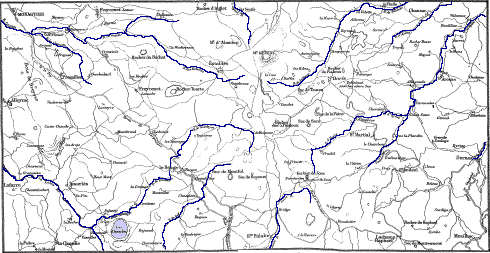
THE GERBIER-DE-JONCS AND MONT MEZENC.
2 m. beyond Lachamp-Raphaél, just under the culminating point of the road (4600 ft. above the sea), is a farmhouse called La Maison Bourlatié, and near it a flattened peak. Just beyond this Maison Bourlatié a road diverges to the right (eastward) from the main road, which take for the Gerbier-de-Joncs, the top of which is distinctly seen after having proceeded a short way, and is hardly an hour’s easy walking from Bourlatié. It is a most interesting and easy excursion. The Gerbier-de-Joncs (Gerbiarum jugum) is an isolated pointed cone, composed of masses and fragments of trachyte, rising 325 ft. above the tableland, 5125 ft. above the sea, and commanding a wide and extensive view. At the base, south side, from under a block of trachyte and some loose stones, wells gently forth the infant Loire, running first into a little circular basin for the use of the adjoining farmhouse, whence it runs down the bank in a tiny streamlet from 3 to 4 inches wide, but soon becomes sufficiently powerful to turn the wheel of a mill. The continuation of the road from the Gerbier goes to Les Etables, 22 m. S.E. from Le Puy, at the foot of Mount Mezenc, 5755 ft. above the sea. Now go on to Le Beage, or return for the night to Lachamp, 22½ m. N. from Aubenas by Antraigues.
Lachamp-Raphaél to Le Beage, 12½ m. W. Char-à-banc, 10 frs. The road, which has been ascending all the way from Valence and La Voulte, continues to ascend till about 1¾ m. beyond Lachamp, where it attains its culminating point, about 4600 ft. A little farther the road to the Gerbier diverges to the right. Less than 2 m. from this the road crosses the Loire, and soon after is joined by the road from the village of St. Eulalie on the way to Montpezat.
Le Beage. Mezenc.
Le Beage, pop. 850. Inns: La Maison Brun; H. des Voyageurs. A dirty cattle and swine breeding village, 4122 ft. above the sea, beautifully
From Le Beage the trachytic mountain of Mezenc (pronounce Mezing) is visited. But the best plan is to go on to Les Etables, 4410 ft. above the sea, 7½ m. N. from Le Beage by the wheel road, but only half that distance by the direct path. Inns: Testud; Chalamel, where pass the night. The hamlet is situated at the foot of Mont Mezenc, 5755 ft. above the sea, or 1345 ft. above Les Etables, and 866 ft. above the hamlet of Mezenc. The ascent takes about an hour.
LE BEAGE TO LE PUY.
Le Beage is 12 m. S.E. from Monastier, passing through Chabanis. On the opposite side of the river are seen Freycenet, 3905 ft. above the sea, and Crouziols, 4½ m. S. from Monastier. Char-à-banc between Le Beage and Monastier, 10 frs.
Le Monastier.
LE MONASTIER, pop. 4000, on an eminence rising from the Colanse. Inns: Commerce; Voyageurs. Coach daily to Le Puy, 11 m. N.W. 10¼ m. S. is Salettes, and 22 m. S. St. Paul de Tartas, 3393 ft. above the sea, at the foot of Mont Tartas, 4424 ft. St. Paul is near Pradelles, connected by diligence with Le Puy and Langogne. The parish church, St. Théofrède, of Le Monastier, was, along with the abbey, founded in 680, and rebuilt in 961 by Ufald, 10th abbot of Monastier, and repaired and enlarged in 1493 by Estaing, the 45th abbot. The edifice exhibits throughout the Auvergne style of architecture. The portal consists of a semicircular arch with 6 mouldings resting on four short columns with sculptured capitals. Above the tympanum and also over the large rectangular window are rude mosaics. Under the eaves of the roof runs a string moulding of grotesque sculpture, representing men and animals. In the interior the capitals of the columns and the corbels on the vaulting shafts are similarly adorned. In the apse is the chapel of Saint Théofrède; with sculptured stone roof. He is the “protecteur du Monastier”— “le bon pasteur, qui s’expose a la mort pour son troupeau”— the “conservateur des fruits de la terre.” (See his litany.)
11¼ m. N. from Le Monastier by diligence along a beautiful mountain-road is Le Puy. The bureau at Le Puy of both the diligence and the courier is at No. 1 Rue du Pont-St. Barthélémy near the large “Place” and the hotels. About half-way from Le Monastier is the Inn: H. des Voyageurs, and about 1 m. more, on an eminence, the village and the still imposing remains of the fortress of Bouzols, 10th cent. Shortly after having crossed the Loire at the town of Brives, the diligence enters Le Puy, 2 m. from Brives.
Le Puy. The Cathedral.
36 m. S.W. by rail from St. Etienne, 89½ m. from Lyons, and 33 m. S.E. from St. George d’Aurac junction, on the line between Clermont and Nîmes (see maps, pp. 26 and 46), is
Le Puy,
pop. 20,000, from 2000 to 2250 ft. above the sea, between the rivers Borne and Dolezon, affluents of the Loire, 2 m. from the town. Hotels: Ambassadeurs; Europe; Nord. To visit Le Puy, the best plan is to begin with the Cathedral. From the high side of the Place de Breuil, at the N.W. corner, ascend by the streets St. Gilles, Chenebouterie, and Raphaél, to the Place des Tables, with a stone pinnacle fountain in the centre. From this ascend by the R. des Tables to the flight of 40 steps, leading up to the tetrastyle portico in front of the church. Forty-one more steps lead up through this portico to the portal of the west façade of the church, built up in the 18th cent., and having against it an altar to Mary. The oblong flat stone at the base of the table of the altar belonged to a dolmen which stood on this hill from the earliest times, and is called the “Pierre aux fièvres,” from its once supposed power of curing of fever those who lay upon it.
From this altar a flight of 27 steps ascends to the left, to the cloisters, while the flight to the right of 32 steps ascends to one of the two south side entrances into the church. The other south side entrance, called the Porte du Fort, 12th cent., presents an extraordinary composition of the florid Byzantine style. On one side of it is the square belfry in 5 stages, commenced in the 11th cent., on the other is the bishop’s palace, and in front a small terrace. At the north side of the church is the Porte St. Jean, 12th cent., preceded by an arch of 28 ft. span. The cloisters are in the form of an oblong square, with 9 arches on the long sides, and five on the short, supported on square piers with attached colonnettes. The south side is the earliest, beginning of the 10th cent., and the western the most recent. The church, built in 550, received a succession of alterations up to 1427, when it was injured by an earthquake. In 1846 it was repaired and restored. The interior consists of eight square compartments, each, excepting the 7th, covered with a dome resting on four massive piers. Above the 7th rises an octagonal lantern tower. Under it is the high altar, with a replica of the miracle-working image,* brought from Cairo in 1251, and presented to the church of Le Puy by Saint Louis in 1254, but destroyed in the Revolution of 1793, when, according to the marble tablet on the pier of this compartment, 20 priests of the diocese were St. Jean, built in the 4th cent, on the foundations of a Roman edifice.
Le Puy: Notre Dame de France.
From Saint Jean commences the ascent of the Rocher Corneille, a mass of volcanic breccia, which forms the summit of Mount Podium. On the top is the image of Notre Dame de France, 433 ft. above the Hôtel de Ville, and 2478 ft. above the sea. It was unveiled on the 27th September 1860, was made from 213 cannons taken at Sebastopol, is 52½ ft. high, and weighs 2165 cwt. The foot is 6 ft. long, the hands 5 ft., and the hair 22 ft. The circumference of the head of the child, J. C., is 14 ft. In the interior of the image a spiral stair of 90 steps leads up to the shoulders, whence an iron ladder of 16 steps extends to the crown of her head. From little openings in this colossal figure are most enchanting views. From the orifice in her right side is seen (2½ m. N.W.) the village of Polignac, likewise on a hill 2645 ft. above the sea, clustering round its old castle. Immediately below is the Aiguilhe, and to the left, 1¼ m. S.E., Ours Mons.
On a projecting part of the rock is, in a kneeling posture, looking up to Notre Dame de France, the figure of Bishop Morlhon, b. 1799, d. 1861, one of the principal promoters of the statue. Bonnassieux is the sculptor of both of them.
Aiguilhe.
Behind the Rocher Corneille rises the isolated volcanic rock called the Aiguilhe, 265 ft. high, 518 ft. in circumference at the base, 45 at the top, and ascended by 266 steps. Fee, 5 sous. On the summit is the chapel of St. Michael, commenced in 962 by Bishop Godescalk, and consecrated in 984. The present building dates principally from the end of the 11th and the beginning of the 12th cent.; restored and repaired in 1850. Originally the interior of it as well as of the cathedral was covered with mural paintings. The views are superb.
Near the foot of the rock, and adjoining the Mairie of Aiguilhe, is an octagonal baptistery, 12th cent., called the Temple of Diana. Near the post office, in the Boulevard St. Louis, is the lower part of a tower which belonged to the town gate Pannessac. The church, at a little distance below, is St. Laurent, 14th cent. In the chapel to the left of the high altar is the grave and mausoleum of the chivalrous Duguesclin, who died on the 17th July 1380, while besieging the fortress of Châteauneuf-le-Randon, between Langogne and Mende.
Le Puy: Musée. Picture Gallery.
In a large new building in the public garden off the Place de Breuil is the Musée, open on Sundays and feast days from 2 to 5. Everything is distinctly labelled. On the ground-floor in the hall to the left are architectural relics from Roman buildings in and about Le Puy. The best fragments belonged to the temple which stood on the site now occupied by the baptistery of Saint Jean. In the hall to the
Upstairs is the Picture Gallery. In the centre room are portraits of the most celebrated natives of Le Puy, and a very good copy of part of the “Danse Macabre,” dance of death, in the church of Chaise-Dieu. Among the portraits are Charles Crozatier, born 1795, died at Paris 1853, the munificent contributor to the museum of this his native town. In the right-hand hall the best paintings, chiefly belonging to the Flemish school, are in the low row, such as Begyer, d. 1664; Caravaggio; Coypel, d. 1707; Franck, d. 1616; Heem, d. 1694; Lippi, d. 1469; Maes, d. 1693; Mieris, 1747; Mierveld, 1641; Poussin, 1695; Rigaud, 1743; Terburg, 1681; Tyr, 1868; Weenix, 1719. In the adjoining small room is a complete collection of the minerals belonging to the Haute-Loire. In the left room among other pictures are: Annunciation, Tintoretto, 1594; Mdlle. de Valois, Mignard, 1695; Mary Stuart, F. Clouet, 1572; Henriette-Marie de France, wife of Charles I. of England, Van der Werf, 1722; Landscape, Hobbema, 1669; Concert, Teniers (vieux); Portrait of Girl, J. B. Santerre, 1717. In the next room are specimens of the lace, blond and guipure, worked by the females inhabiting the towns and villages among the mountains of Ardèche and the Haute-Loire, of which articles Le Puy is the great emporium. The specimens and sample books are in cases. In the centre case are specimens from Alençon, Binche, Brussels, Cevennes mountains, Malines, Russia, Valenciennes, and Venice; the Corsage with lace trimming of the gown Marie Louise wore on the day she was married to Napoleon I.; also some of her ribbons.
Ours Mons.
1¼ m. S.E. from Le Puy is Ours Mons, 2463 ft. above the sea, and 180 ft. above the plain. The prospect from the top is considered by Mr. Scrope most remarkable; “exhibiting in one view a vast theatre of volcanic formation, in great variety of aspect, containing igneous products of various natures, belonging to different epochs.”
LE PUY TO LANGOGNE BY PRADELLES.
(Map, p. 46.)
Le Puy, 2045 ft., to Langogne, 2940 ft. above the sea, 26 m. S. by coach, along an admirably-constructed road, over a high, cold, treeless tableland, whose culminating point, 3900 ft., is about a mile south from the hamlet of La Sauvetat, 6 m. N. from Pradelles. 8 m. from Le Puy is Montagnac, on the Cagne, 3123 ft. From this hamlet a road diverges 8 m. S.W. to Cayres, 3727 ft. above the sea, pop. 1450. Inn: Du-Lac-du-Bouchet. A lace and cheese-making village, about 1½ m. by a good road from the extinct crater of Le Bouchet, 231 ft. higher, than Cayres, now a lake of 222 acres and 92 ft. deep. It is very similar to Lake Issarlès, near Beage (which see p. 85). After Montagnac the coach arrives at Costaros, 3510 ft., 12 m. S., where the horses are changed. Then Sauvetat, 16 m. from Le Puy, pop. 300, and afterwards Pradelles, 3771 ft., pop. 2000, with two small inns, 21 m. from Le Puy and 5 m. from Langogne. The coach stops at Langogne railway station, where the omnibus of the Cheval Blanc map, p. 46).
Pradelles to Mayres, 18 m. S.E., char-à-banc, 20 to 25 frs., by a good but a high and exposed road, passing Peyrebelle (p. 95), La Narce, 8¾ m., pop. 900, the Col Chavade, 4170 ft. above the sea, near the source of the Ardèche, whence the road descends rapidly, passing above the hamlet of Astet. This is not a good entrance into Ardèche.
From Le Puy a coach starts daily from near the post office for St. Bonnet, Usson, and Craponne, pop. 4000, directly N. from Le Puy, and 12½ m. E. from Chaise-Dieu by stage-coach.
LE PUY TO LANGEAC BY ST. GEORGES.
(Map, p. 46.)
For geological excursions the railway between Le Puy to Langeac by St. Georges d’Aurac is very useful. The culminating point of the line, 3658 ft, is in the tunnel between Darsac and Fix-St. Geneys. This railway crosses at right angles the Velay mountains, full of extinct volcanoes, extending from Chaise-Dieu to Pradelles.
Espaly. Borne. Darsac.
Le Puy to Langeac, 36½ m. W. by rail. The first part of the line traverses a most picturesque country among great basaltic cliffs. 1 m. from Le Puy the train passes the village of Espaly, and by the face of basaltic columns rising from the Borne and its little affluent the Riou-Pézeliou, in whose bed zircons and blue sapphires have been found. On the opposite side of the Borne is the great mass of basalt called the Croix de la Paille, with a display of prisms in three tiers, called les orgues d’Espaly. The village, pop. 2300, is built at the foot of a rock of volcanic breccia crowned by the scanty ruins of a castle built in 1260 by Guillaume de la Roue, bishop of Puy.
8¾ m. from Puy is Borne, 2535 ft. above the sea, pop. 390. A ramble in the ravine of Borne forms a pleasant and easy excursion from Le Puy. 5½ m. E. from this station, or 3¼ m. W. from Le Puy, is Polignac, passed by the train. The village, pop. 2500, with church of 11th cent., is at the foot of a rock of basaltic breccia crowned by the imposing ruins of a fortress dating from the 11th cent. A stair of 132 steps (ascent dangerous) leads up to the terrace of the Keep, 14th cent., commanding an extensive view.
13 m. W. from Le Puy is Darsac, 2914 ft. above the sea. A small hamlet, with a restaurant, the station for Chaise-Dieu, 13¾ m. N., fare 2½ frs., and for Arlanc, 24¼ m. N., or 10½ m. beyond Chaise-Dieu.
La Chaise-Dieu.
The coach first passes through Allègre, pop. 1700, a dirty little village, 5 m. N, on the side of Mont de Bar, 3583 ft. above the sea, with the ruins of a castle built in the 14th cent. Mont de Bar and Mont du Bouchet are the best specimens of extinct volcanoes in the Velay chain. From this the diligence, after having skirted for 8 m. the high cold region of the Velay mountains, arrives at La Chaise-Dieu, 3576 ft. above the sea, pop. 2000. Inns: Lion d’Or; Centre; Nord. A dirty, decaying village, in which its imposing church participates. Robert, a scion of the ducal house of Aurillac, and canon of St. Julien in Brioude, obtained permission from the canons of N. D.
The interior of the church is 301 ft. long, surrounded by 22 tall plain slender octagonal piers, from which springs the groining, which spreads itself over the stone-vaulted roof. The nave is 44 ft. wide, and the aisle on each side 15, all the three roofs being of the same height. The church is lighted by long narrow pointed windows, one between each two columns, excepting at the apsidal termination, where a triangular projection affords space for three windows. The tracery has little depth, and is of the simplest design. The choir, 131 ft. long, is separated from the nave by an ugly rood-loft. It contains 144 carved cedar-wood stalls, and above them on both sides 17 pieces of Arras tapestry, 16th cent., from designs by Taddeo Gaddi. In the centre is the mausoleum of Clement VI. His white marble effigy, with the hands folded and the papal Triregnum on the head, reclines on an altar table of black marble.
On the N. side of the screen of the choir, just behind the pulpit, is the “Danse Macabre,” or dance of death, a favourite subject with artiste from the 12th to the 14th cent. The ironic grin and jocund gait of the skeleton death contrast vividly with the dismayed and demure expression of the great and mighty kings, priests, and warriors, young and old, gay and sedate, he marshals off, in the midst of their projects and plans, to the dark silent grave. Under it is the sadly mutilated mausoleum of Queen Edith of England, wife of the unfortunate Harold. Near it is the more perfect mausoleum of the last abbot of La Chaise-Dieu.
Arlanc. Ambert. Fix-St. Geneys.
La Chaise-Dieu to Vichy by Arlanc and Ambert.
10½ m. N. by coach from La Chaise-Dieu, 24¼ m. N. from Darsac, and 11¼ m. S. from Ambert-du-Puy, by a beautiful road, is Arlanc, pop. 4500, Inn: H. des Princes, between the rivers Dore and Dolore,
11¼ m. N. is the manufacturing town of Ambert, pop. 8000, 43 m. N. by rail from Vichy; whence the ascent is made, 3 hrs., of the culminating point of the Forez mountains, the Pierre-sur-Haute, 3882 ft. above the sea. 15 m. from Ambert, and 11¾ m. S. from Thiers, is Olliergues, pop. 2000, on a hill rising from the Dore. It contains an old bridge, some 13th cent. houses, and the ruins of a castle which belonged to the family of the Tour d’Auvergne. 13 m. farther N., or 8¾ m. S. from Thiers, is Courpière, pop. 4000, on the Dore, with some old houses and the ruins of the castle of Courte-Serre. 61 m. N. from Darsac, or 36¾ m. N. from Ambert, is Thiers, south from Vichy. For Vichy see p. 358; Thiers, p. 367.
The next station west from Darsac by rail (see map, p. 46) is Fix-St. Geneys, 18 m. from Le Puy, 3274 ft. above the sea, pop. 900. Inn: H. des Voyageurs, situated on a tableland above the valley of the Sioule, covered on one side with firs. 2½ m. farther is the station for the hamlet La Chaud, 2950 ft. above the sea, on the Sioule. 7½ m. farther is Rougeac, with a castle 1923 ft. above the sea.
St. Georges-d’Aurac. Monistrol.
The most westerly station on the line is St. Georges d’Aurac, 1872 ft. above the sea, 86½ m. W. from St. Etienne, and 32 from Le Puy. 58½ m. N. by rail is Clermont, and 131 m. S. by rail is Nîmes (see map, p. 26). Near the station is the inn Lombardin. The village, pop. 500, is 2 m. S.E. Other 2 m. E. is the château Chavagnac, the birthplace of General Lafayette. 5½ m. W. is Voute-Chilhac, pop. 800, most picturesquely situated on a narrow peninsula formed by the Allier, opposite the mouth of the Avesne. The church was built in the 15th cent. by Jean de Bourbon, bishop of Le Puy. Passengers going north change carriages at the station of St. Georges d’Aurac. 4½ m. S.W. from St. Georges, 90½ W. from St. Etienne, and 36½ from Le Puy, is Langeac, 1690 ft., 63 m. S. from Clermont, and 127 m. N. from Nîmes. All the trains halt here. Inns: H. Lombardin; Pascon. Their omnibuses await passengers. Langeac, on the Allier, is a pleasant town near the station, situated in a vast plain. The parish church dates from the 15th cent. To the N.E. of the town, in the valley of Morange, is a coal-basin of 1450 acres. (Map, page 46.)
15 m. S. from Langeac is Monistrol-d’Allier, 2000 ft. above the sea, pop. 1200. The station is on the E. side, and the town on the W. side of the river. Coach by a picturesque road to Le Puy, 17 m. N.E. by St. Privat, 2930 ft., pop. 1600, on the stream Rouchoux, which runs in a deep gully between high cliffs. A little way beyond the hamlet of Chiers the road attains its culminating point, 3739 ft. above the sea. 10 m. from Monistrol is Bains, 3235 ft., pop. 1300, with a very old church. 1¼ m. farther the road passes the picturesque rock of Cordes, 3012 ft., and then descends to Le Puy by La Roche, 2895 ft., and Mont Bonzon. Coach from Monistrol to Saugues, 6½ m. W., 3116 ft., pop. 4000, on the side of a hill, rising from the beautiful valley of the Margeride. In the neighbourhood is a monument p. 44).
Le Pouzin. Privas.
LYONS NÎMES 81 91 LE POUZIN, pop. 3000, Inn: H. Lion d’Or, on the Ouvèze, which here enters the Rhône. The town has foundries and the remains of its old castle. Junction with line to Privas, 13¼ m. W. Privas, pop. 8000. Inns: Croix d’Or; Louvre. On an eminence 1060 ft. above the sea, at the foot of Mt. Toulon, 838 ft. higher, and at the confluence of the Chazalon, the Mezayon, and the Ouvèze. The town, looking well from a distance, consists chiefly of narrow, crooked, steep streets, and dingy houses. From the promenade called the Esplanade, planted with plane trees, is an excellent view of the picturesque valley of the Ouvèze, and of the volcanic chain of the Coiron, especially of Mount Combier. 1¼ m. from Privas, on the plain of the Lai, is a house called the Logis du Roi, in which Louis XIII. established his headquarters in 1629, when, with Cardinal Richelieu, he besieged the Protestant inhabitants in the town, commanded by the brave Montbrun.
From Privas, coach daily, 11 m. N. to Ollières, on the Eyrieux. Inn: H. du Pont, comfortable. This coach meets at Ollières the coaches to La Voulte and Valence on the Rhône, and the coaches to Le Cheilard and to St. Pierreville. The latter is the coach to take for the Source of the Loire and Mont Mezenc (see pp. 84, 85). Coach also to Aubenas, 18 m. S.E. (See next page, and map p. 46.)
Rochemaure.
LYONS NÎMES 98 74 ROCHEMAURE, pop. 1300, Auberge Gabarre. Suspension bridge across the Rhône. The modern part of the village is built along the high road, but the old on the steep slopes of the basalt rocks crowned by the ruins of the castle. There are many ways up to the top; the best and most frequented commences just opposite the “auberge,” traverses the centre of the curious old stony village, passes on the right the chapel with the arms of Ventadour and Soubise on the portal, then ascends by the battlemented wall to some miserable habitations, among what was the seigneurial manor, of which large portions still remain. Next to it, on a needle-like peak of nearly horizontal columns of basalt, rises the Keep, like a spear piercing the sky. A narrow path leading so far up will be found round the N.W. corner. The views are superb, of the valley of the Rhône on one side, and on the other of the Coiron mountains. These ruins, which from below look slim and airy, are the remains of a massive edifice constructed principally of basaltic prisms in the 12th cent. by the family of Adhémar de Montheil, and reduced to its present condition by order of Louis XIII.
A road up the gap on the N. side of the hill leads in a little more than an hour to Mount Chenavari, 1668 ft., distinctly seen from the top of the gap. On the summit is a tableland bordered with massive basaltic columns. At Rochemaure the olive trees begin to appear.
Le Teil.
LYONS NÎMES 95¾ 76¼ LE TEIL, pop. 3200, with some small inns. Omnibus awaits passengers for Montelimart, 3¼ m. E., on the other side of the Rhône (p. 48). Branch line to Alais, 62¼ m. S.W., on the line between Nîmes and Clermont-Ferrand. From Vogué, on this branch, 17½ m. S.W. from Le Teil, and 44¾ m. N.E. from Alais, a smaller branch extends 12 m. N. to Nieigles-Prades. The Nieigles-Prades line forms a convenient entrance into Ardèche (see maps, pages 26, 46, and 56).
Aubenas. Vals.
Vogué, Aubenas, Vals, Neyrac, Thueyts, Mayres.
5 m. W. from Teil, on the branch line to Alais, is Aubignas (Alba Augusta), pop. 530, once an important Roman station. 6¼ m. N. from Vogué is Aubenas, pop. 8000, Inn: H. Durand, on a hill covered with vines, olives, and mulberry trees, rising 328 ft. above the Ardèche, and commanding an extensive view of the valley of the river. On the highest part of the town are the church and the fine old castle, now containing the college, the hospital, and some other public institutions. Aubenas is the centre of an important trade in raw silk, butter, and cheese. At Vesseaux, a village to the north of Aubenas, excellent chestnuts are grown. (Maps, pages 56 and 46.)
3¼ m. N. from Aubenas is La Begude, the station for Vals. Omnibus awaits passengers. VALS, pop. 4000, on the Volane, famous for its Mineral Waters. Hotels: Des Bains, on an eminence above the bathing establishment and the gardens. In the same neighbourhood are the Hotels Parc; Juliette; Délicieuse; Lyon; Orient. All the important springs are also in this part. In the town are the Hotels Europe; Durand; Nord; Poste. The Pension in the Hôtel des Bains is from 12 to 15 frs., in the others from 9 to 10 frs. Season from 1st May to October. Vals is prettily situated on the Volane, in a hollow among hills covered with vineyards and studded with mulberry and chestnut trees. The springs, gardens, baths, and best hotels are all at the eastern extremity. Near the H. du Parc is the intermittent fountain, and from it, across the bridge, are the springs Vivaraises, under a grotto; and, adjoining them, the spring Juliette, while a little beyond is La Délicieuse. The springs Madeleine, St. Jean, Précieuse, and the others, belonging to the Société Générale, are all farther up the river, nearer the town, at the second bridge. None of them are so pungent nor so agreeable to the palate as the Juliette and the Délicieuse. The properties of all are much the same. They give tone to the stomach, assist the action of the liver and kidneys, and remove paralysis of the bladder. They are all cold, easily digested, and may be drunk at any time. They contain bicarbonate of soda, lime, and magnesia,
Antraigues.
5 m. N. from Vals, or 9 m. from Aubenas and 16 m. from Privas, is Antraigues, pop. 2000, situated on the side of three basaltic rocks, at whose base flow three impetuous mountain torrents—the Bise, Mas, and Volane. From the heights behind the town there is a magnificent view. In the neighbourhood is the extinct crater, the Coupe d’Aizac, covered with a beautiful reddish lava. Inns: Brousse; Glaise.
Neyrac-les-Bains. Thueyts.
AUBENAS TO LANGOGNE BY MAYRES.
(Maps, pp. 56 and 46.)
Coach daily from Aubenas to Mayres, 18 m. W. It passes through Pont-de-la-Baume, 945 ft., and by the eminence on which is Neyrac-les-Bains, the Nereisaqua of the Romans. Inns: H. des Bains; H. Fournier. 2½ m. from Pont-de-la-Baume, 7 from Vals, and 9½ from Aubenas. It is situated within the crater of Saint Léger, containing 8 acidulous, alkaline, and chalybeate springs, temp. 81° Fahr. From several fissures issues carbonic acid gas; from one place, the Trou de la Poule, in sufficient quantity to kill birds and dogs in 2 or 3 minutes. In the neighbourhood is the volcano of Soulhiol. 2 m. W., on the left bank of the Ardèche, at its confluence with the Médéric, is Thueyts, pop. 2600, Inn: H. Burine, situated on a bed of lava from the crater of Mont Gravenne, 2785 feet above the sea. Through this bed the Ardèche has, in cutting a passage for itself, laid bare a grand display of basaltic columns from 150 to 200 ft. high, extending nearly 2 m. down the valley. To the W. of the Bourg are a bridge with two stages of arches across the Médéric, called the Pont du Diable, and the falls of the Gueule d’Enfer, 330 ft., which, unless in rainy weather, have very little water. From this part commences the Pavé-des-Géants, a tableland composed of granite and basalt of an average height of 214 ft. from the base, lined with vertical prisms. To the right, at the extremity of this wall of rock, is the Echelle du Roi, a staircase of 192 steps of broken prisms, within a natural shaft or chimney, leading up to the top of the tableland, where there is a good view. The best is from Mont Gravenne. The ascent requires about 1 hour.
The diligence now ascends the Ardèche to Mayres. About half-way, near the hamlet of La Mothe, are the cliffs called the Rocher d’Abraham, 4358 ft. above the sea, of which the Bauzon is the continuation.
Mayres.
5½ m. from Thueyts is Mayres, pop. 2900. Inns: France; Commerce. 1810 ft. above the sea, at the foot of the Croix de Bauzon, 5055 ft. above the sea, and on the Ardèche, which here flows in a narrow gorge between granite cliffs. The stage-coaches go no farther than Mayres. For Langogne, 22 m. N.W., it is necessary to hire a vehicle. From Mayres the road commences to ascend the Col, passing above the hamlet of Astet at the foot of the Rocher d’Astet, 4925 ft. above the sea.
7 m. from Mayres is the summit of the pass or Col de la Chavade, 4170 ft. above the sea, near the source of the Ardèche. 2½ m. farther is La Narce, pop. 900. A little beyond, or 26 m. from Aubenas and Peyrebelle, 4195 ft. above the sea, where for 25 years the landlord and his wife robbed and murdered the travellers that came to their house. Nearly 4 m. N. from Peyrebelle is Coucouron, pop. 1400.
The road now attains the height of 4266 ft., where, on account of the snow and wind, it becomes very dangerous in winter.
35 m. from Aubenas and 5 from Langogne is Pradelles, 3771 ft., 16 m. from Le Puy by coach and 5 from Langogne (see p. 88, and maps, pages 26, 56 and 46).
Prades. Jaujac.
Prades, Pont-de-la-Baume, Jaujac, Montpezat, St. Eulalie, and Source of the Loire.
For the main loopline, see map p. 56; for the rest, map p. 46.
11¾ m. N. from Vogué station and 5½ from Aubenas station is the terminus of this branch line, called Nieigles-Prades, as from it coaches take passengers to both of these towns. Nieigles, pop. 1600, is situated on an eminence rising from the N. side of the Ardèche. In the vicinity are coal-pits and rows of basalt columns supporting terraces covered with chestnut trees. On the south side of the Ardèche, and to the east of Jaujac, is Prades, pop. 1200, on the Salindre, in the centre of an important coal-basin.
Near the railway terminus is the village of Pont-de-la-Baume, pop. 900, Inns: H. du Louvre, etc., 955 ft. above the sea, at the confluence of the rivers Fontaulière and Alignon with the Ardèche. One of the best headquarters for visiting the basalt rocks in the neighbourhood, both from its own position and the facility afforded here for going elsewhere, as the coaches for Vals, Mayers, Burzet, Neyrac, Montpezat, and Jaujac pass through it.
3¾ m. from La Baume, or 7½ from Aubenas by coach, is Jaujac, the Jovis aqua of the Romans, pop. 2600. Inn: Union. On an eminence above the Alignon, of which nearly the whole of the right bank from Pont-de-la-Baume to Jaujac is lined with countless basaltic prisms. From the town cross the bridge, and at the mill descend to the path by the side of the river, where there is an admirable view of the columns, which, however, are not vertical. About ½ m. from the town is the Coupe de Jaujac, an extinct volcano, which has burst through the coal formation of this valley, bounded by mountains of granite and gneiss. It is ascended easily in 20 minutes. At the foot of the crater, just where the path leading to the top commences, is a gaseous chalybeate spring; not unlike those of Vals.
Montpezat.
14 m. N.W. from Aubenas, or about 8 from Pont-de-la-Baume by diligence, is Montpezat. The road from Aubenas ascends by the Ardèche, which it crosses; La Baume at the foot of the hill, on which are the ruins of the castle of Ventadour, 14th cent. Farther on, within a mile of Montpezat, are seen the ruins of the castle of Pourcheyrolles, built in 1360 on a plateau of prisms 115 ft. high, over which flows the Pourseilles, an affluent of the Fontaulière or Fontollière. Near the
Montpezat-sous-Bauzon, pop. 2600, on an eminence 1877 ft. above the sea, rising from the Ardèche. Inns: Europe; Poste. This is the terminus of the diligences. The river Fontaulière has its source in the crater of Mount La Vestide, the largest in the Vivarais. By the new road La Vestide is 6½ m. N.W. from Montpezat. Coach to the base of the peak and back, 10 frs. The peak is 325 ft. high from the base, but the crater is nearly 900 ft. deep. By the old road, ascending by the village of La Faud, La Vestide is only 4 m. distant.
MONTPEZAT TO LE PUY.
To go from Montpezat to Le Puy, 43 m. N.W., hire vehicle to Le Beage, 16 m. N.W., 20 to 25 frs., and from Le Beage to Le Monastier, 12 m., 10 frs. Diligence between Le Monastier and Le Puy. From Montpezat the road ascends by the hamlet of Le Pal, 3888 ft., opposite the extinct volcano, the Suc du Pal, 724 ft. higher, with 3 cones. North is Lake Ferrand, and still farther north, Lake Bauzon, 4832 ft. above the sea. After the hamlet of Le Pal the road passes the hamlet of Rioutort, crosses the river Padelle, and arrives at the village of Usclades, 9 m. N. from Montpezat, pop. 600, whence a winding road ascends to Le Beage, 6¼ m. N. (see p. 84).
Sainte Eulalie.
From Montpezat a road extends 13 m. N. to the source of the Loire by Rioutort and Sainte Eulalie. Sainte Eulalie, pop. 650, Inn: Faure, in a little valley on the left bank of the Loire, about 2 m. S. from the road between Lachamp-Raphaél and Le Beage. The large peak seen in the distance is the Gerbier-de-Joncs, at the foot of which is the source of the Loire. To go to it, from the main road walk down to the one-arch bridge which crosses the still infant Loire, and walk up the path by the side of the stream (see p. 84, and maps pp. 46 and 85).
Ruoms. Largentière.
Ruoms, Largentière, Vallon, Pont d’Arc.
See map, page 56.
25½ m. S.W. from Teil, 8 m. S.W. from Vogué, and 36½ m. N.E. of Alais, is Ruoms. Station for Largentière, 9 m. N., 1¼ fr. For Joyeuse, 8 m. W., and for Vallon, 6¼ m. S. Largentière, pop. 3000. Hotels: Europe; France. Coaches to Joyeuse, Les Vans, and St. Ambroix. St. Ambroix, pop. 5000, on the Cèze, H. Luxembourg, is a town with silk-mills and glass-works. Near Ambroix is Robiac, station for Besseges, with important coal-fields. Largentière, or properly L’Argentière, situated in the ravine of the Ligne, derives its name from the argentiferous mines in the neighbourhood. On the tableland behind the Palais-de-Justice is the picturesque village of Chassiers, pop. 1300. Joyeuse, pop. 2300. Inns: H. Nord; Europe. Situated with its suburb, Rosières, on the Baume. The town has part
The town of Ruoms, pop. 1300, has an interesting church, and a considerable part of its old walls, towers, and gates.
Pont d’Arc.
VALLON TO THE PONT D’ARC.
(Map, p. 56.)
One hour from Ruoms station by omnibus is Vallon, pop. 2500. Inns: *H. du Louvre; Luxembourg; Temple Protestant. From Vallon the Pont d’Arc is 75 minutes distant by the stony road over the hill, which, as far as the shoulder of the last ridge, is also the road to the caves. A boat from Vallon to the Pont costs 10 frs.; to St. Martin it costs 35 frs., time 7 hrs. St. Martin is 3 m. from the railway station of St. Just, on the railway on the west side of the Rhône (see p. 98). The landlord of the Louvre can procure either a guide for the Pont, 2 frs., or for the caves, 5 frs., or the boatman for sailing down the Ardèche. The Pont d’Arc is a natural bridge across the Ardèche, composed of a calcareous rock, pierced with a span of 180 ft., through which the river flows majestically. The soffit of the arch is 100 ft. high, but the total height of the parapet is 230 ft., and 48 thick. There are several rocks similar to this in France, but this one is unrivalled in size, and in the beauty and grandeur of the surrounding scenery. A lovely little plain, covered with vines, peach and mulberry trees, is enclosed by the circle of vertical cliffs 500 ft. high, which at one part extend over the river. In these cliffs are great stalactite caves, approached by iron ladders from the top. One of them is 490 ft. long and 100 ft. high. Vallon is famous for black truffles, honey, and chestnuts. Pigs are used for finding the truffles. They are better than dogs, because they are not so apt to be carried off by other scents, as, for example, when a hare or a partridge suddenly appears upon the scene. (See under Carpentras, page 54.)
LYONS NÎMES 102½ 69½ VIVIERS, pop. 3300. Inn: Louvre. The station and the new town are along the road parallel to the Rhône: the old town with the cathedral is on the hill behind. The streets are narrow, crooked, and steep. Here, along the W. side of the Rhône, are lofty limestone cliffs, the quarrying and preparing of which forms the principal industry of the place. Coach to Aps, 8 m. N.W. on the Teil and Alais railway, passing St. Thomé, pop. 600, at the junction of the Nègue with the Escoutay, which flows through a deep ravine. Omnibus to Châteauneuf, on the opposite or east side of the Rhône.
Bourg-St. Andeol. St. Just.
LYONS NÎMES 109½ 62½ BOURG-ST. ANDEOL, pop. 4500. Hotels: Luxembourg; Europe; their omnibuses await passengers. Omnibus also for Pierrelatte (page 50), on the opposite or E. side of the Rhône. Le Bourg has handsome quays alongside the Rhône, a church founded in the
LYONS NÎMES 115 57 ST. JUST and St. Marcel station, from which both towns are less than a mile, but in different directions. 2½ m. from the village of St. Just is St. Martin, pop. 600, on the left or N. bank of the Ardèche. A ferry-boat crosses the river. On the other side, a little farther up, is Aiguèze, pop. 450, with ruins of castle, and farther down St. Julien, but not seen from St. Martin.
Boats are hired at St. Martin to visit the caves of St. Marcel, 4½ m. up the river, or 3¾ m. W. from the village of St. Marcel. The price depends upon the time the visitors make the boat wait. The cave consists of a tunnel, 4¼ m. long, which here and there widens out into spacious lofty caverns hung with stalactites. Some parts are very steep, slippery, and fatiguing. The visit requires from 6 to 7 hours, and certainly none but ardent lovers of walking in dark caverns should undertake the labour. The sail, however, is pleasant. The nearest hotels are at Pont-Saint Esprit and at Bourg-St. Andéol.
Pont-St. Esprit.
LYONS NÎMES 119 53 PONT-ST. ESPRIT, pop. 5000. H. de l’Europe. Coach to La Croisière, on the other or east side of the Rhône. (See for bridge and Croisière page 50.) Station of the steamboat between Lyons and Avignon. Pont-Saint Esprit, on the west side of the Rhône and on the western Rhône railway, makes a convenient and comfortable resting-place, with pleasant promenades by the side of the Rhône. Down from the bridge are the church of St. Pierre, now abandoned, and St. Saturnin, built in the 15th cent. Near it is the citadel, built between 1595 and 1620. Within, down a steep stair of 36 steps, are the remains of a chapel constructed in 1365, now a military storehouse. On the south side is a beautifully-sculptured portal, supported on each side by an elegant pinnacled buttress. The arch, 20 ft. span, is richly decorated. In the Hôtel Dieu (infirmary) are a few specimens of old (faïences) pottery. Carriage from the hotel to Valbonne (4½ m. S.W.) and back 15 frs. At Valbonne is a beautifully-situated Chartreuse convent with about 30 inmates. The drive is pleasant (see map, page 56).
Carriage also from the hotel to Saint Martin, on the Ardèche, 4½ m. N.W., there and back 12 frs. (For St. Martin see above.)
7½ m. south from Pont-St. Esprit is Bagnols-sur-Cèze, pop. 5000. H. du Louvre. Omnibus at station. A manufacturing town. Coach to Uzès, 17 m. W.
LYONS NÎMES 132½ 39½ LAUDUN, pop. 2200, about 2½ m. west from the station, and 10 m. from Orange, is built on a hill 350 ft. high. The vineyards in the neighbourhood produce a good white wine. Junction with branch to Alais, 35½ m. west, by Connaux, St. Pons, Cavillargues, Seyne, Celas, and Mejannes; small and uninteresting towns (see map, p. 26).
Roquemaure. Pont-d’Avignon.
LYONS NÎMES 137½ 34½ ROQUEMAURE, pop. 3100. Inns: H. du Nord; H. du Midi. Omnibus at station. Situated on the small branch of the Rhône which encircles the island of Mémar, 1¼ m. long. The best part of this curious old town is in the neighbourhood of the Hôtel du Midi, where are the public promenade with large trees, the great embankment to protect the town from the invasions of the Rhône, and the ruins of the old castle, of which the most remarkable part is the square tower perched on the point of a great rock. Orchards, vineyards, and mulberry groves surround the village. Roquemaure, however, like all the other small towns on the Rhône, has a dingy and untidy appearance. Clement V., first Pope of Avignon, died here in 1314. 5 m. W. is Taval, pop. 2200, where a good wine is made.
LYONS NÎMES 144¾ 27¼ PONT-D’AVIGNON, station on the west side of the Rhône for Avignon (p. 63). Omnibuses from the hotels await passengers. The omnibus between Avignon and Villeneuve passes the station every hour. Tram every ¼ between the station and Avignon.
7 m. S. from the Pont-d’Avignon is Aramon, pop. 2800, on the Rhône, at a considerable distance from its station. 3¾ m. farther is Thezièrs, pop. 650, with the church of St. Amans, 11th cent., and the ruins of a castle. (Map, page 66.)
LYONS NÎMES 159¾ 12¼ REMOULINS, pop. 1400, with ruins of a castle. From Remoulins branch to Uzès, 12½ m. N.W. On this line, 3¼ m. from Remoulins and 9¼ from Uzès, is Pont-du-Gard station, on an eminence, whence walk down to the bridge. (For description and directions see pp. 64 and 104, and map page 66.)
Uzès.
UZÈS, pop. 5600, Inn Bechard: on an eminence surrounded by picturesque calcareous rocks. From the inn walk past the church St. Etienne, then turn to the left, and having gone down the avenue ascend the double stair leading up to the beautiful terrace, on which, to the left, stands the Cathedral, and to the right, projecting from the
Sernhac-Lédenon.
After Remoulins the train halts at the station Sernhac-Lédenon. Lédenon, pop. 700, is about 2 m. W. from the station, and Sernhac, pop. 1200, about the same distance E. 7 m. from Nîmes is the St. Gervasy-Bezouce station, and 2½ m. nearer, Marguerittes, pop. 2000, with a handsome modern church, and in the cemetery the ruins of the chapel of St. Gilles, 12th cent., seen from railway.
Nîmes.
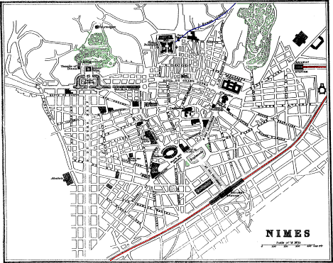
172 m. S.W. from Lyons, 27½ m. S.W. from Avignon, 31 m. N.E. from Montpellier by Gallargues, 17 m. W. from Tarascon, 80 m. N.W. from Marseilles, and 450 m. S.E. from Paris by Clermont-Ferrand, is
NÎMES,
population 64,000, on the Vistre, 150 feet above the sea. A flight of steps as at Tarascon leads from the town up to the station. At the foot of these steps is the Hôtel des Arts, pretty comfortable room 2 frs., dinner with wine 3 frs. The trams start from in front of the house. In the town are: On the Esplanade, the H. Luxembourg, the most expensive. By the side of it, fronting a garden, the H. du Midi or Durand, from 9 to 12 frs. Fronting the amphitheatre the Cheval Blanc, commercial, 8 to 10 frs. Opposite the Maison Carrée, the H. Manivet, 9 to 12 frs., the most conveniently situated for visiting the sights. Their omnibuses await passengers at the foot of the station stair. Post Office, No. 4 B. du Grand Cours, between St. Baudine and the Public Gardens. Telegraph Office in the Place de la Salamandre, a small “Place” off the B. des Calquières. Temple Protestant, the Porte d’Auguste, and the handsome new church of St. Baudine, with its two elegant spires, are at the north end of the B. des Calquières, beyond the Esplanade.
Sights.—The Amphitheatre, the Maison Carrée, and the Roman Baths. Cab Stands are found at the station, at the Amphitheatre, and at the Maison Carrée. Cab carrying 4, 2 frs. per hour.
A straight, wide, and handsome avenue extends from the station to the Esplanade; having in the centre a large fountain with four marble colossal statues by Pradier round the base, representing the Rhône, the Gardon, and the fountain nymphs of Nemausa and Ura. On the top of the pedestal is a larger statue, also by Pradier, representing Nîmes, with its face towards the station. Behind it are the Palais de Justice and the Amphitheatre, and to the left the church of St. Perpetua.
Nîmes: Amphitheatre.
The great sight in Nîmes is the Roman Amphitheatre, the most perfect extant. In form it is elliptical, of which the great axis measures 437 ft., and the lesser 433 ft., and the height 70 ft. Around the building are two tiers of arcades, each tier having 60 arches, and all the arches being separated from each other by a Roman Doric column. Above runs an attic, from which project the consoles on which the beams that sustained the awning rested. Within each arcade, on the ground-floor and on the upper story, runs a corridor round the building, the upper one being roofed with stone slabs 18 ft. long, reaching
On the N. side of the amphitheatre is the Boulevard St. Antoine, with, on the left hand or W. side, the Palais des Beaux Arts, including the Public Library, containing 60,000 vols.; the Archæological Museum, containing many interesting articles, chiefly Roman, found in the neighbourhood; and the Picture Gallery, containing, among other pictures, a Magdalene by Guido; A Holy Family, a Head of John the Baptist, and a portrait of himself, by Titian; A Head of a Girl and a Return from Hunting, by Rubens; Portraits of Vanloo and of his mother, by himself; Cromwell regarding Charles I. laid out in his coffin, by Paul Delaroche, his chef d’œuvre; “Nero and a Sorceress experimenting on a slave with the poison they were preparing for Britannicus,” by Javier Sigalon; An old woman, by Greuze; also works by Gérard Dow, Claude Lorrain, Metzu, Ostade, Paul Potter, Ruysdael, Van den Welde, and Wouvermans.
At the N. end of this Boulevard is the church of St. Paul, with frescoes on gold and blue grounds by H. and P. Flandrin.
Nîmes: La Maison Carrée. Cathedral.
Beyond are the Theatre and the Bourse, and opposite them La Maison Carrée, a beautiful specimen of a Roman temple, probably part of the Forum, with which it was connected by colonnades extending east and west. It is 75 ft. long, 39 wide, and 39 high, and is supposed to have been erected in the time of Antoninus Pius. It stands on a platform, and is encompassed by a quadrilateral peristyle of 30 Roman-Corinthian columns surmounted by a plain architrave, scroll frieze, sculptured dentils, and a fluted cornice. All the columns are attached,
Eastward, in the centre of the old town, is the Cathedral St. Castor, built in the 11th cent., but nearly rebuilt in subsequent times. The most venerable portion is the façade, constructed of large blocks of stone. A delicately-cut frieze, representing scenes from Genesis, extends under the roof. The eaves of the pediment are supported by brackets with acanthus leaves. The table of the third altar, right hand, in the interior, is sculptured in much the same style as the exterior frieze.
Nîmes: Roman Baths. Tourmagne. Fort.
N.W. from the Maison Carrée is the Public Garden, adorned with vases and statues among shrubs and flowers, overshadowed by tall elm and plane trees. To the left are the remains of a temple or fane (called the temple of Diana), dedicated to the Nymphs, built B.C. 24, of huge carefully-hewn blocks of sandstone, and reduced to its present state in 1577. The little of the ornamental work that remains is very much mutilated. Opposite the temple, protected from the troublesome winds of Nîmes, are the Roman Baths, about 12 ft. below the level of the gardens, the vaulting being supported on small columns, over which rise open stone balustrades. Adjoining is the copious spring that supplies them, as placid but somewhat larger than the Fontaine of Vaucluse (p. 65).
From the fountain a road leads up the wooded slopes of Mont Cavalier to an octagonal structure called the Tourmagne, 90 ft. high, erected before the Roman invasion, and supposed to have been a tomb. It was originally filled with rubble, which was excavated in the 16th cent. in search of treasure. The winding staircase of 140 steps was added in 1843. The view from the top is extensive. Fee, 30 cents.
Eastward from the Tourmagne is the Fort, built by Louis XIV., now the town prison. On the western side of the fort are the remains of the reservoir, castellum divisorium, which received the water brought by the canal from the aqueduct of the Pont-du-Gard. This canal still brings water to the town reservoir, on the opposite or east side of the fort.
In the year of Rome 788 a strong wall was built round Nîmes, 7 ft. high, pierced with 10 gates; of which there still remain two; the Porte d’Auguste, originally fronting the road to Rome, now at the E. end of the Temple Protestant, and the Porte de France at the extremity of the Rue Carrètérie. (See plan.)
The ancient name of Nîmes is Nemausus, one of the cities of Gallia Jus Latii,” and therefore was independent of the Roman governors. Its most notable product then was cheese, which was exported to Rome; now it is raw silk, for which it is the principal emporium in the south of France. The wines of Nîmes are in repute in Paris, particularly the Costière and the St. Gilles, called also Vin de Remède. Both deteriorate after the sixth year in bottle. Nicot, who introduced tobacco into France, and Guizot, the minister of Louis Philippe, were born at Nîmes.
Pont-du-Gard.
13½ miles from Nîmes is the Pont-du-Gard, built by the Romans in the reign of Augustus as part of the aqueduct, 25 m. long, which, from the neighbourhood of Uzès (page 99), brought the waters of the Eure and Airan to the reservoir beside the fort, of which only vestiges now remain. This “Pont,” which spans the valley or banks of the river Gardon, consists of three rows of arches, whose total height above the bed of the river is 156 ft. The two lower stories are formed of hewn stones, placed together without the aid of any cement; but the mason work underneath the channel of the third or top story is of rough stones cemented, by which all filtration was prevented. The first or lowest row consists of six arches, with a span of 60 ft. each, except the largest, which has 75 ft. The second row consists of eleven arches of the same dimensions as the first, and the third of 35 arches of 15 ft. span. A stair from the right bank of the river leads up to the watercourse above the topmost tier of arches. In the striking boldness of its design this bridge exhibits a decided improvement and superiority over all the other Roman aqueducts. The arches are wider, and the piers in proportion lighter, and had the same principle been extended so as to have formed it of one single row from top to bottom, it would have equalled in the skill and disposition of its materials the more judicious and more elegant structures of modern times (see Roquefavour, p. 77). Take ticket to Pont-du-Gard Station. But if with luggage, and on the way to Avignon, take ticket to Remoulins, where leave the luggage, and take another ticket to the Pont-du-Gard, which having visited, walk back to Remoulins station, where take ticket for Pont Avignon (see under Avignon, p. 64).
79 m. S.E. from Nîmes by rail is Marseilles (p. 111), passing Tarascon, 17 m. (p. 66), and Arles, 25 m. (p. 68).
Valleraugue.
NÎMES TO MILLAU BY VIGAN.
See Map, p. 26.
58 m. N.W. by rail from Nîmes is Vigan, whence coach 43 m. W., 9 hrs., to Millau, on the line to Paris by Rodez. There are no towns of importance on this line, though some parts, especially towards Vigan, are very picturesque. 27 m. from Vigan, and 31 from Nîmes, is Quissac, pop. 1800, junction with line to Lezan, 9 m. N., and thence 4½ m. E. to Mas des Gard, on the Nîmes and Alais line. 9 m. W. from Lezan is St. Hippolyte-Le-Fort, pop. 4500, on the sluggish Vidourle. From this the line goes westward by La Cadière to Ganges, 9½ m. from Vigan, on the Hérault, 595 ft. above the sea, pop. 5000, H. Croix Blanche, omnibus at station. The most pleasant town on the line. 2½ m. farther is Jumène, 682 ft. above the sea, pop. 3000, with coal and iron mines. 4 m. from Vigan, at Le Pont, 666 ft. above the sea, the line crosses the Hérault, and entering the picturesque valley of the Arre follows the course of that river to Vigan, pop. 6000. Inns: Voyageurs; Cheval Blanc; both in the “Place,” near the statue of the Chevalier d’Assas, born at Vigan in 1733, and “Mort glorieusement à Clastercamp à 27 ans.” Vigan on the Arre, an affluent of the Hérault, is 860 ft. above the sea, in a hollow between steep mountains, with terraces of vineyards, olive, mulberry, fig, and chestnut trees to nearly their summits. The town consists of narrow, crooked, badly-paved streets. The hospital was founded in 1190. In the promenade near the post office are some old chestnut trees, disfigured with knots. In the neighbourhood are several coal-pits, worked, however, with difficulty, on account of the water they contain. Nearly a mile westward is the Fontaine Isis, the source of the water-supply of the town. Beside it are the cold sulphureous springs of Cauvalat.
Valleraugue.
Coach daily to Valleraugue, Inn: Aresque, 14 m. N., in a very picturesque region, on the Hérault, in a deep wooded valley between the Aigoual mountains towards the N., and the Espéron mountains towards the S. The principal source of the Hérault is a little higher, towards the W., at Séreyrède. From Valleraugue the ascent is made in about 2½ hours of Mt. Aulas, 4665 ft. above the sea, the culminating point of the Espéron, commanding a magnificent view. The source of the Dourbie is just a little to the S. of Valleraugue, and of the Tarn to the N., but on the other side of the Aigoual. Excellent fishing, botanising, and geologising in this neighbourhood.
Larzac.
Le Vigan to Millau, 43 m. W. by diligence, 9 hrs. The first village the coach passes is Molières, on a hill above the road, with coal-mines. From this the road ascends to the villages of Esparron, 5½ m., and Arre, 6¼ m., from Vigan. A little higher up the coach leaves by a tunnel the valley of the Arre, and enters that of the Vis, with the village Alzon, 12½ m. from Vigan, pop. 900. Inn: the Souterraine, the best on the road. After a pretty steep ascent of 7 m. the coach arrives at Sauclières, pop. 2200, Inn: H. du Nord, producing excellent Inn: Commerce, 23 m. from Vigan and 20 from Millau. The coach having traversed the valley of the Dourbie, full of chestnut trees, reaches Nant, pop. 2000, a poor village, on an eminence, 16 m. from Millau. Shortly afterwards the diligence crosses the monotonous tableland of Larzac, 2790 ft. above the sea, and arrives at the village of La Cavalerie, with some small dolmens. 7 m. W. is Millau, on the line to Paris by Rodez.
The Riviera: Itineraries The Riviera: Maps The Riviera: Text General Index
ITINERARY (pages 107–280)
THE RIVIERA.
The Riviera. Hotels, productions, climate 107
Marseilles. Hotels, trams, sights, excursions 111
MARSEILLES to MENTON. The French Riviera 122
Marseilles to Toulon, passing several pretty little towns, of which the most important is La Seyne (p. 123). From Toulon omnibuses and diligences run to the neighbouring villages and to the more distant towns in the interior. The most start from the Place d’Italie (pp. 124 and 129).
Toulon to Dardenne from the “Place” to the W. of the Place Puget (p. 128), to Hyères from the Place Puget (pp. 124, 133), Cap Brun and Ste. Marguerite from the Place d’Italie (p. 128), to Le Pradet from the Place d’Italie (p. 128).
Toulon to Meounes and Brignoles by Belgentier, by diligence. As far as Meounes the road traverses a picturesque country (p. 129), to Collobrières by La Crau and Pierrefeu (p. 130).
Steamer to La Seyne (pp. 124, 127), to St. Mandrier (p. 127), to the Iles d’Hyères or d’Or (pp. 124, 131).
The Iles d’Or. Porquerolles, Port-Cros, Ile du Levant 131
Toulon to Hyères 132
Hyères. Hotels, cabs, drives, stage-coaches, excursions, productions, climate 133
Hyères to Les Salins, La Plage and the peninsula of Giens (p. 140); to Carqueyranne by Pomponiana (p. 141); to Bormes and Lavandou (p. 142); by coach to St. Tropez (p. 134); whence steamer to St. Raphael (p. 147); or coach to Le Luc (p. 144).
La Pauline. Diligence and train to Hyères 142
Carnoules. Carnoules to Gardanne by rail, passing Brignoles and Ste. Maximin 142
Le Luc. Le Luc to St. Tropez by coach, across the Maure mountains 144
Les Arcs to Draguignan by rail. From Draguignan diligences start to Aups, Barjols, Fayence, Lorgues and Salernes, and correspond at these towns with other diligences 145
Cannes to Auribeau, (p. 156), to Cannet, (p. 154), to Cap d’Antibes (p. 154), to Castelaras (p. 156), to Croisette (p. 154), to Croix des Gardes (p. 155), to Estérel (p. 155), to Grasse (p. 160), to the Iles de Lerins (p. 156), to Mougins (p. 156), to Napoule and Theoule (p. 155), to Pégomas (p. 156), to St. Cassien (p. 155), to Vallauris by the Golfe de Jouan and Californie (p. 152).
Grasse to Cagnes by Le Bar, the Pont-du-Loup and Vence (p. 163), to Digne by St. Vallier and Castellane (p. 165), Digne to Riez, Gréoulx, Volx and Manosque (p. 166).
Nice to St. Martin Lantosque by coach, and thence to Cuneo by the Col di Finestra 180
Nice to Puget-Theniers and Saint Sauveur by coach. From St. Sauveur an excellent road by the side of the Tinée ascends to St. Etienne; whence bridle-road E. to Vinadio (map, p. 165). 182
Nice to Cuneo by the tunnel of the Col di Tenda 182
Savona to Turin by Carru, Bra, Cavallermaggiore and Moncalieri, 90¾ miles N. 183
Beaulieu to Port St. Jean and the Lighthouse—a pleasant walk 185
Monte Carlo to Nice by the coast-road 189
Monaco to La Turbie and the Tête de Chien 191
MENTON to GENOA—the western part of the Italian Riviera, called also the Riviera di Ponente 200
Bordighera, up the valley of the Nervia, to Pigna 201
San Remo to Monte Bignone 205
GENOA to PISA and LEGHORN—the eastern Italian Riviera, or the Riviera di Levante 219
Avenza to Carrara by rail—a very easy and interesting excursion 222
Pisa to Florence by Pontedera and Empoli (map, p. 199) 227
Pisa to Florence by Lucca, Pistoja and Prato 227
Lucca to the Baths of Lucca 230
Florence to Vallombrosa 277
Genoa to Turin by Alessandria—a very interesting railway journey 279
END OF THE RIVIERA.
MAPS AND PLANS (pages 107–280)
PAGE
Cannes, Environs of 155
Showing the drives around Cannes and Antibes.
Cannes, Plan of 149
Corniche Road 185
Showing the course of the upper Corniche Road from Nice to Menton, as well as that of the lower and perhaps more beautiful road between Nice and Monte-Carlo, extending along the coast, nearly parallel to the railway.
This map contains also the Environs of Nice, Monaco, and Menton.
Estérel Mountains, or Frejus and St. Raphael to Cannes 146
Florence, Plan of 234
The most beautiful walk or drive is by the Porta Romana up to the Piazza Michelangiolo.
Galleria degli Uffizi 237
The Florence Picture Gallery. Contained in two vast edifices on both sides of the Arno; united by long corridors, which from the Uffizi straggle down to the river, cross the bridge, and reach the Pitti Palace by the upper story of the houses bordering the Via Guicciardini.
Genoa, Plan of 214
Hyères, Environs of 129
As the excursions from Hyères and Toulon are nearly the same, the environs of both towns are given on the same map.
Italian Riviera, or the Riviera from Ventimiglia to Leghorn 199
Called also the Riviera di Ponente and the Riviera di Levante. The French Riviera is given on the map of the “Rhône and Savoy,” and parts on a larger scale on the maps of the “Corniche Road” “Marseilles to Cannes,” and the “Durance to the Var and San Remo.”
Leghorn, Plan of 226
Marseilles, Plan of 113
Marseilles to Cannes 123
This map shows the position of the towns and villages on the coast and in the interior, the roads between them and the Marseilles canal; which, from the Durance, enters the sea at Cape Croisette. At the southern side are given the “Iles d’Or,” called also the “Islands of Hyères,” of which the largest is Porquerolles.
Nice, Plan of 171
Pisa, Plan of 224
The object of this plan is to enable tourists to find their way unaided to the Leaning Tower, the Cathedral, the Baptistery, and the Campo Santo or Cemetery. The frescoes on the walls of the Cemetery require the cultivated talent of an artist to appreciate. Those who have to remain over the night should take one of the hotels close to the station.
Savona to Rapallo 211
Illustrating the position of the pleasant winter stations of Arenzano, Pegli, Sestri-Ponente, Nervi, Santa-Margherita-Ligure and Rapallo.
The Durance to the Var and San Remo 163