XII. UP AND DOWN THE COLUMBIA RIVER.
Reading edition
AN UNGRATEFUL REPUBLIC—THE COLUMBIA COMPARED WITH OTHER RIVERS—SNOW-PEAKS—SALMON-CANNERIES—ASTORIA AND THE MOUTH OF THE RIVER—CAPE HORN AND ROOSTER ROCK—WATER-FALLS—THE CASCADES—SALMON-WHEELS—IN THE HIGHLANDS—THE LAST OF THE MOHICANS—LOW AND HIGH WATER—THE SCENERY AND THE RAILROAD—THE “PLACE OF THE WINDS”—“SWIFT WATER”—A RIVER TURNED ON EDGE.
The proverbial ingratitude of republics has never been better illustrated than by the fact that not one of our forty-two States is named after the discoverer of America. True, there are more than fifty Columbia counties, townships, cities, and villages in the United States, and thirty more have adopted the name Columbus, while the capital of the country lies in the District of Columbia; but this district comprises an area of only sixty-four square miles, and in a country where so much is thought of big things, Columbus surely ought to have been sponsor of one of our largest States. An excellent opportunity was missed, on the occasion of the recent admission of Washington Territory to statehood, of changing its name to Columbia. This would not only have prevented much confusion in the mails, but would have been singularly appropriate, for the reason that Washington is bounded on the south by the Columbia River, and on the north by British Columbia.[1]
However, even if it failed to use its opportunity for adopting the name of Columbia for one of its States, the Northwest has done more to honor the name of Columbus than any other part of the country; for here is British Columbia with its magnificent mountain scenery, more than eight times as large as the State of New York; and, better still, the Columbia River, three thousand miles in length, with the grandest river scenery in the world. I have repeatedly seen the Hudson, the St. Lawrence, Mississippi, Missouri, Sacramento, the Rhine, Elbe, and Danube, and none of these rivers impressed me as deeply as the Columbia, which, with the exception of the castles on the Rhine, combines the best features of all of them, and adds to them what they all lack—a background of lofty mountains covered with eternal snow. Grandeur is the watchword of the Columbia, which, with this mountainous background and the stupendous sculpture of its banks, towers above other famous rivers as the high Alps of Switzerland do above our Adirondacks and Catskills.
In entitling this chapter “Up and down the Columbia” I do not wish to frighten the reader into the belief that I intend to take him over the same ground—or water—twice, but merely to indicate that Portland is to be our starting-place. From that city steamers leave daily to make the trip of one hundred miles down to Astoria and the ocean, while others go up the river about one hundred and ten miles, to the Falls. The former trip should be taken first, to avoid an anticlimax.
Portland, Oregon,—which, although founded two centuries later than its namesake in almost the same latitude in Maine, has already almost double the population of the latter (sixty thousand),—is, as I remarked in the last chapter, doubtless the most picturesquely situated city in the United States. From the densely wooded green hills which enclose it on the west, the city is seen spreading itself comfortably and without unsanitary crowding along both sides of the Willamette River, which is about a mile wide at this place. East Portland and Albina are on the east side of the river, and beyond them, at a distance of about fifty miles, this picture is framed in by the Cascade Range and half-a-dozen giant snow-peaks. Mt. Hood and Mt. St. Helens, both covered with eternal snow, are so vast that on clear days they seem to rise just beyond the outskirts of the city, and delightful glimpses of them are caught in the streets. Less conspicuous, because farther away, but still adding to the charm of the scene, are Mt. Tacoma and Mt. Adams on the left, while on the right, the snowy tops of Mt. Jefferson and the three sisters are visible. To the left of Mt. Hood the Columbia River can be seen in the distance, like a silver cord showing the way to the deep cañon which it has worn through the Cascade Mountains.
Portland is practically a seaport, although situated a hundred miles up the Columbia, and twelve miles more up its tributary, the Willamette, which, up to this point, is deep enough to receive the largest ocean steamers, although in dry summers the channel has to be carefully watched, and lighterage resorted to in some cases. For hours after the day boat to Astoria leaves the city, the snow-mountains above mentioned are visible on deck, in ever-new groupings as the boat follows the winding course of the river. This is by far the most striking feature of the lower Columbia scenery; for the minor ridges of the coast range are insignificant compared with the cascade ridges of the “middle” Columbia, and the fir-fringed banks are usually low, and have none of the steep palisades and isolated rocks which give continuous grandeur to that part of the river. The banks of the Willamette River, below Portland, resemble those of the Columbia, and indeed this river, which is hardly known outside of Oregon, becomes so wide and majestic before it reaches the Columbia, that a careless passenger would not notice the transition from one river to the other. It would be difficult, however, to be inattentive here, for the place where the Columbia receives the Willamette is one of the most interesting spots in its course. The Willamette—which should be called the Oregon, since that name has been taken away from the Columbia (“where rolls the mighty Oregon,” as Bryant still could write), or should at least receive back its old Indian name Wallámet—meets the Columbia almost at right angles in two currents, being divided here by one of those pretty little islands which abound along this part of the river and give it some resemblance to the St. Lawrence. They are submerged in spring, and but a few inches above the level of the water in summer, when they are covered with a luxuriant growth of grass and shrubbery—ideal grazing-grounds for thousands of head of cattle; yet Oregon still imports much of her meat and butter from the East.
As the river-banks become wider and wider, and the scenery somewhat monotonous, the salmon industry begins to attract attention. During the legal salmon season, from the first of April to the end of July—which is also the tourist season in Oregon, since in July the forest fires begin which shroud the whole State, with its fine mountain scenery, in a dense cloud of smoke, lasting till September—the river steamers are liable to be stopped at any moment in midstream by boats loaded to the edge with salmon, which are to be conveyed to one of the numerous canneries that line the last thirty miles of the stream. These canneries are buildings of the flimsiest construction, inhabited chiefly by Chinamen, and by young bears caught in the neighboring hills and chained to the front door. The salmon are thrown on the wharf, where they are seized by the Chinamen, who carry them in, throw them on long tables, chop off the heads, disembowel and clean them, and cut them up into small lumps for the cans—all in about as much time as it takes to write this sentence. In the larger canneries everything, from the making of the cans to putting on the labels, is done on the premises. Some of the canneries are built on the shore; but as the river, where the ocean comes in sight, widens out into a bay seven miles wide, the canneries are built in midstream, on piles, and it is an odd sight to behold horses—real land-horses, not hippopotami—dragging in the nets on these flimsy mid-river structures. The river view is disfigured on all sides by the ugly stakes driven in to hold the nets that constitute the salmon-traps. The meshes of these nets are large enough to allow the small salmon to escape, but not large enough for the seals, which occasionally get into one of these enclosures and work sad havoc with the fish and the nets. Several million dollars are said to be invested in the boats, nets, and canneries of the Columbia River: but the recklessness of the fishermen threatens to kill the goose that lays the golden eggs; for the Columbia River fisheries, which a few years ago were the largest in the world, have of late yielded less and less each year, and in 1889 they sank to third rank, with three hundred and thirty thousand cases, Alaska being at the head, with six hundred and eighty-eight thousand, and British Columbia second, with four hundred and thirteen thousand cases. The law is stringent enough, but it is not always obeyed; and it will have to be supplemented by extensive hatcheries if the Columbia River salmon, which is the best flavored on the Pacific Coast, is to regain its former supremacy.
The headquarters of the salmon-fisheries are located at the amphibious town of Astoria, the first civilized settlement in Oregon, but whose hoary age of eighty years does not seem to protect it against the gibes of irreverent tourists—probably because it is so small for its age. Mr. Joaquin Miller describes it as a town which “clings helplessly to a humid hill-side that seems to want to glide into the great bay-like river”; and Mr. Nordhoff unkindly insinuates that the most important building in the town is a large saw-mill, which is kept busy day and night in a wild struggle to curb and suppress the forest which is forever encroaching on the town, and threatens to crowd it into the river. However, just at present the Astorians are very busily engaged in digging away at the hill-side and filling up the bay. They expect to have a railway some day, which will bring the wheat and the apples of the Willamette Valley to their wharves, instead of to Portland; but it will require a good deal more digging and filling up before there will be room for all those products. At present the greater part of Astoria is still built on piles, washed by the tides; and as the pavements are not very well looked after, tourists should beware of walking about after dark. The occupants of many of the houses might easily take a salt-water bath before breakfast, by simply tying a rope round the waist and lowering themselves from the window.
Although Astoria is only about a hundred miles distant from Portland, it has nearly twenty inches more of rain per annum, and in summer its climate is considerably cooler; wherefore some Portlanders use it as a summer resort. A much larger number, however, go across the bay to Ilwaco, and camp on the fine beach which extends for over twenty miles northward. The boat which takes them across touches at Fort Canby, whence an interesting walk of a few miles through a dense forest takes one to the lighthouse on Cape Disappointment, just north of the notorious Columbia River bar, which in spite of all improvements continues at certain seasons, and in stormy weather, to detain ships for days at a time. The view from this lighthouse of the foaming breakers in the bar is splendid, and in low tide the scene is varied by long sand-banks on which thousands of seals bask in the fitful sunshine. These voracious animals do their fishing in the daytime, and at night their place is taken by the human fishermen, who show the same reckless spirit in regard to their own lives as they do in regard to the extermination of the salmon. In their eager rivalry, some of them approach too near the breakers, and many have thus shared the fate of the sailors lowered from the Tonquin in 1811, which is so graphically described by Washington Irving in his “Astoria.” By the way, I could not help noting the difference between these Astorians and the Granadans in Spain, in their attitude towards Irving. Both have been celebrated by him in fine volumes of poetic prose; but whereas in Granada the principal hotel is named after Irving, whose name is thus heard whenever a train arrives, the Astorians seem to ignore entirely the author who has chosen the name of their town for one of his most readable books.
The trip back to Portland may as well be made on a night boat, as everything worth seeing can be seen on the down trip. Not so with the upper or “middle” Columbia, from Portland to the Dalles, which cannot be seen often enough, and which present on the down trip aspects of the scenery so different from those enjoyed on going up, that a return ticket should be taken by all means. Such a ticket, from Portland to the Dalles and back, costs five dollars, for which you can spend two whole days on the Columbia. I have seen a great part of three continents; but if I were asked what I considered the best investment of a five-dollar bill I had ever made for combined æsthetic enjoyment and hygienic exhilaration, I should name this return trip on the Columbia River. Tourists who have time for one trip only should go up the river, because in that direction the scenery is arranged most effectively, becoming ever grander and wilder till the climax is reached in the marvellous rapids above Dalles City.
The day boat leaves Portland at six o’clock in the morning, and on the way down the Willamette we once more can admire the imposing white forms of Hood, St. Helens, Adams, and the top of Tacoma,—now in full view, now peeping from between the firs which line the banks. At the Columbia junction the boat turns to the right, and makes its first stop at Vancouver, noted for its fine site, with a superb view of Mt. Hood, and as being the military headquarters of the Department of the Columbia. It lies on the northern or Washington side of the river, and, oddly enough, almost all the stations along the whole river, excepting Dalles City, are on that side, the Oregon side being generally wilder and less hospitable. The scenic features are about equally divided between the two States. Each has its low green islands at intervals along the banks; each its densely wooded shores, its bare rocks, precipitous palisades and water-falls; and each its snow-mountains—Hood and Jefferson being on the Oregon side, St. Helens, Adams, and Tacoma on the Washington side. Generally the trees or shrubs grow right to the water’s edge, but here and there is a strip of sandy beach. On both sides there are innumerable charming home sites, on gently rising ground, with fertile soil, plenty of wood and water, excellent market facilities by rail and steamer, and the finest scenery in the United States for a background. Yet these shores, which in the next century will hold hundreds of thousands of happy farmers, are now an absolute wilderness, and an hour may pass before a farmhouse or village is sighted from the steamer. Had the unreasoning multitudes who rushed to Oklahoma quietly taken up homesteads in this region, which is so favored by climate, soil, and scenery, they would have avoided their wholesale disappointment. The steamship company is very accommodating to the few settlers along the river, and stops at frequent intervals to take on their lumber, shingles, salmon, farm products, and to land merchandise for them. In low water much ingenuity is required to make a landing at these informal stations.
Two hours after leaving Portland, Mt. Hood, whose base has been previously concealed by the Cascade ridges, suddenly comes into view, life size, from top to base. Were the banks of the Columbia as flat and monotonous as those of the lower Mississippi, this sight alone would crown it king of rivers. For a full hour the steamer sails straight towards this mountain, as if intending to land at its base for a supply of ice from its glaciers; but all at once it moves to the left as the steamer provokingly changes its course. For two hours more, however, the mountain remains in sight till it is once more hidden behind the crests of the Cascades. Tourists who wish to ascend this mountain or to explore its glaciers and cañons, get off above the Cascades at the town of Hood River, near the mouth of the river of that name which carries the melting snows of the mountain to the Columbia. A hotel was opened last summer, just below the snow-line, so that the trip can now be made with great comfort. Mt. Hood is eleven thousand and two hundred feet high, and is ascended by numerous parties every summer, including ladies. Like all the Oregon chain of mountain peaks from Shasta to Tacoma, it is an extinct volcano, and still gives evidence of its past condition by the sulphurous fumes which in some places are encountered during the ascent.
Nothing could be more delightful than the ingenuity with which the Columbia panorama is arranged. For the first five hours, while the banks present nothing of thrilling interest, the giant snow-peaks lend grandeur to the scene. As soon as the last of these, Mt. Hood, disappears, the banks themselves begin to fascinate the attention by innumerable picturesque formations, and a few hours later, when the Highlands have been left behind and the banks become lower again, Mt. Hood once more comes into view, more and more prominently, till at the last station of our trip, the Dalles, it seems nearer and more magnificent than even at Vancouver or Portland. Thus there is not a dull moment between Portland and the Dalles.
The river itself is almost as awe-inspiring in its grandeur as the snow-peaks visible from it. No other river has ever given me such a vivid and overpowering sense of sublimity as the Columbia by its great expanse of watery surface, and its tranquil, deep, majestic movement. And whereas the Mississippi, at a corresponding point in its course, is so muddy that one almost hesitates to bathe in it, the Columbia is so clear and pure that in a glass it seems like well-water and tastes almost as good. The color varies with wind and weather, but is usually a yellowish green, as grateful to the eye as a new-mown lawn. Standing at the prow of the boat, surveying this vast expanse of placid or agitated water, it is a fascinating exercise of the imagination to think that almost every gallon of this mammoth stream came originally from some different creek, spring, melting glacier, or snowfield—some of them in the Cascade Mountains close by, some in the Rocky Mountains in distant Territories; for the Columbia’s sources are in British Columbia and in seven States and Territories,—Oregon, Washington, Idaho, Montana, Wyoming, Utah, and Nevada. Think what romantic cañons, what vast, gloomy forests, these waters have passed through on their way from the crest of the continent to the ocean; what numbers of speckled trout have darted through them in the mountains; what hordes of big salmon and sturgeon in the Columbia; and what exciting scenes they have noted of seals chasing these unfortunate fish! For even as far up the Columbia as this the seals make their excursions. A hundred and fifty miles from the ocean, they can be seen here basking on a sand-bank projecting from an island into the middle of the river. Some of them float about on logs, and others swim to within thirty feet of the steamer, looking, with their heads above the water, exactly like swimming dogs.
About eleven o’clock, as Mt. Hood disappears, Rooster Rock comes into sight, and the scenery begins to resemble that of the Hudson River Highlands. Rooster Rock is a large boulder which, from different points of view, looks like an uplifted thumb, or like a mammoth seal with head on high, just ready to plunge. It stands on a projection from the shore, which looks like an island, and it has a few small firs growing on its bare sides that subsist apparently on the food of air-plants. The interesting points now begin to crowd each other, and barely fifteen minutes elapse before another of the famous sights of the Columbia comes in view,—Cape Horn, which, at first sight, seems merely a precipitous rock projecting into the river; but as the boat draws nearer and begins to round it, all the passengers rush to the left side of the ship, and a chorus of rapturous admiration bursts from their lips. Cape Horn is a vertical wall of bare rock, rising abruptly out of the water, and standing on a pretty row of grooved stones, resembling little pillars sculptured in high relief. In the centre of the rock a miniature cascade runs down smoothly over a mossy bed. Presently, as the boat moves on in close proximity to the rock, another precipitous wall, even higher than the first, rises above it, adorned with several more miniature water-falls, whose moss-grown channels are the only green in the brown, rocky scene. Cape Horn deserves its name, not only because it is a promontory which the boat has to round, but because at times the wind blows so wildly that none but steam-vessels can pass, and canoes and sailing-vessels have been detained there for days. The Columbia River wind-current, by the way, is very accommodating to sailing-vessels; for it usually blows up stream, so that it is almost as easy for them to go up as down. In the future commercial development of this region this will be a factor of considerable importance.
The Master Landscape-Gardener who planned the Columbia River provided not only for a gradual dramatic crescendo to a climax, but for constant scenic variety. So, after the snow-mountains and Rooster Rock and Cape Horn, the tourist is treated to the sight of a few picturesque water-falls. The first of them is the Multnomah Fall, which is sighted only a few minutes after leaving Cape Horn. At first it is somewhat disappointing, since only the upper part can be seen; but as the boat approaches nearer, it is revealed in its true size, of eight hundred feet, in two divisions. It is the death plunge of a lively mountain stream which has worn a channel in the rock that looks as if a giant had scooped out a wide groove with a shovel. The trains of the Oregon Railway and Navigation Company pass very near the falls, and always stop a few minutes to enable the passengers to see them. But after all, the only way to see them properly is to visit them on a special picnic excursion, one of which leaves Portland for this spot almost daily in summer. There is a bridge spanning the chasm in front of the falls from which an excellent view is obtained, and the adventurous climb down and pass under the falls, through a delightful fern grotto and “cave of the winds.” The water in the pool formed by the fall is cool as ice even in midsummer. The picnic parties generally visit another fine fall, the Latourelle, on the same day, noted for the beautiful cave into which it seems to fall, directly from the blue sky, and for the curious markings of its rocky surroundings. This fall, however, though close to the Columbia, is not visible from the river; but only ten minutes above the Multnomah Falls the boat passes the Oneonta Falls, less high but more massive than the Multnomah. A curious phenomenon is here seen sometimes—a shadow-fall, reproducing the water-fall with all its movements and its inverted water-rockets. Still another fall is seen above the Oneonta, so close to the edge of the river that in high water it probably plunges directly into the Columbia.
After this water-fall episode the highland mountain scenery again monopolizes the attention; for we are now in the midst of the Cascade range, which is a continuation of the Sierra Nevada of California. That the Columbia should have ever been able to force a passage through this lofty chain is a marvel. But then marvels abound in this region. Here, for instance, on the Washington side, is a monstrous basaltic rock, close by the river, completely isolated, without a trace of connection with the neighboring ridges. It is called Cathedral Rock, is curiously marked and furrowed by wind and weather, and covered in patches by the irrepressible fir-trees, which are larger than they seem at their great elevation. How did this rock get there? It looks like a mammoth glacier boulder; but, incalculable as is the force of glaciers, no ice-river could have ever borne this massive rock on its back. Perhaps Mt. Hood, in a volcanic fit, hurled it there. But impressive as this sight is, the passengers should not allow Cathedral Rock to distract their attention from the surrounding mountain scenery, which is really much more noteworthy than the rock itself. Near it, to the right, is a mountain about two thousand feet above the river, which is an exact copy of Mt. Hood, without its snow; and adjoining it is a unique mountain of about the same height, but with a summit at least half a mile long and absolutely level. But it would take volumes to describe all these imposing mountain formations. Opposite Castle Rock, and below, are miles of magnificently sculptured palisades, compared with which those on the Hudson River are of toy-like dimensions. They are beautifully mottled with green shrubs and mosses and yellow lichens, and fringed above and below by ribbons of young fir-trees. And to think that all this superb scenery has been known to civilized man only one century!
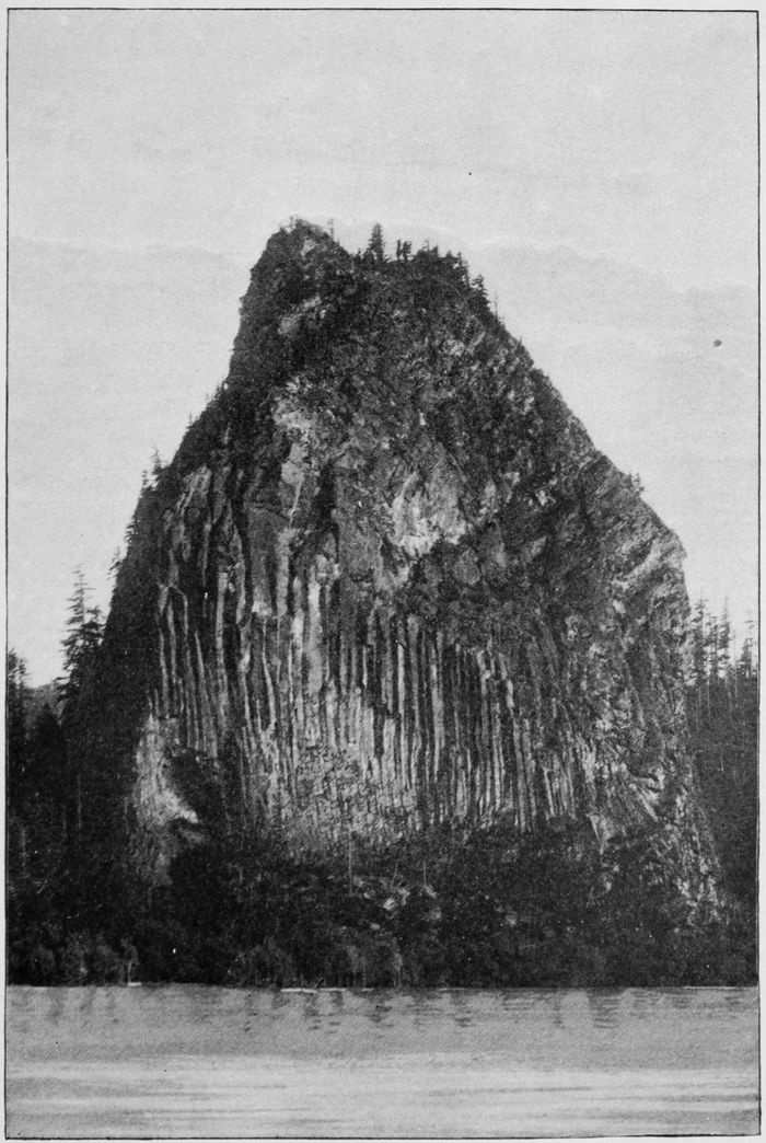
CASTLE ROCK—COLUMBIA RIVER.
We now approach the famous Cascades of the Columbia, the place where, according to the Indian tradition, a natural bridge once existed, formed by the water digging a tunnel for itself through the mountain. The legend goes on to relate how the rival volcanic monarchs, Hood and Adams, which face each other on opposite sides of the river, once had a fight and hurled huge rocks at each other, some of which fell on this arch which spanned the Columbia, and demolished it. The fragments, filling the river-bed, created the rapids which now obstruct navigation. Day excursions from Portland do not go beyond this point; but tourists who wish to get a glimpse of the Cascades themselves, and of some of the finest scenery on the river, must leave the boat here and take another one about five miles up the river, for the Dalles. The Columbia River boats at present depend for their existence on freight more than on passengers, and the greatest drawback to the enjoyment of the Columbia River trip is the tedious delay of an hour or two, necessitated by loading all the freight on the train which takes us from the Lower Cascades to the Upper Cascades, on the Washington side, and then again loading it on the upper boat. However, the mountain scenery is very fine at this place, and the air so exhilarating that the offence is greatly mitigated thereby.
The government has been at work for about twenty years constructing a canal and locks for the boats; but a million dollars are still needed to complete the task, and meanwhile the building of the railroad on the Oregon side has rendered its completion a matter of less urgency. The little six-mile railroad on the Washington side, which connects the two boats, is the first ever built in the Northwest, and is a curiosity not only on that account, but also because it affords a good view of the rapids from the car windows. The fact that the river is here narrowed to a quarter of its regular width, assists the rocky débris in its bed in creating a dizzy rush of tumultuous, roaring waters and foaming waves o’erleaping each other. It contrasts finely with the calm, majestic movement of the lower Columbia. But it must be admitted that these rapids are not so grand or exciting as those of the Niagara or the St. Lawrence; nor do passengers ever get an opportunity to “shoot the rapids,” as on the last-named river. Not that it is impossible to do so. One captain has taken down several steamers and smashed only one so far; but the risk can only be taken in very high water.
Usually the Columbia is very high in early summer, especially when there are a few hot days, with much snow in the mountains. The difference between high and low water is forty-two feet, and some care has to be used, therefore, in building houses near the bank. In 1889, however, there was no snow in the mountains to melt, as there had been no snow-storms and hardly any rain in Oregon during the whole of the preceding winter; consequently the Columbia was lower than it had been for almost a generation; not quite as low, however, as the rivers of Europe in 1132 and 1313, when the Rhine and the Danube could be crossed on foot without wetting the shoes. Fishermen do not like the low water in the Columbia, because in that state it is so clear that the salmon succeed in avoiding the traps laid for them, including the murderous “salmon-wheels,” which are turned by the current and scoop in the fish, young and old, with the nets attached to them. These wheels are especially numerous about the Cascades, and do much to hasten the extermination of the salmon.
Before the advent of civilized man on the banks of the Columbia, the Cascades used to be the great fishing-place of the Indians, who congregated here in large numbers to catch and dry their winter supply of salmon. They were a lazy, cunning, treacherous crew, who gave the early explorers much trouble, and proved by their actions that although fish may possibly be good intellectual or brain food, it does not equally develop the moral faculties. For these tribes used to guard the narrowest parts of the river, and levy toll on all passersby, very much like the robber-barons on the Rhine. But that was in the good old times, a hundred years ago. At present only a handful of these Indians are left to haunt these regions and fish for their daily bread. The salmon-wheel has displaced the canoe and spear, and the Indian, who used to be so hardy that he went about unclothed the greater part of the year, has become so weakened by the clothing, whiskey, and vices of “civilization” that old and young are now dying out rapidly of consumption. In return for all the harm it has done them, the government allows the Indians the privilege of fishing with spears for their own sustenance during the “closed” season. Consequently it is easy in Portland during that season to get salmon “caught by Indians,” or “in the Rogue River.” It is well to have laws and law-abiding communities.
One of the most interesting features of the Cascades is that the upper steamer can be moored quite close to the head of the rapids, where there are some picturesque islands. This absence of a dangerous current is due to the great depth of the river. The débris which causes the rapids has blocked up the channel so effectually that the average depth of the Columbia is twenty feet greater from the Cascades to the Dalles than below, although the banks are almost as widely apart. A splendid view of a black forest scene is obtained from the deck of the upper steamer before it leaves for the Dalles. It is a sportsman’s paradise, and a brakeman assured me he had seen two bears at once on one of the steep banks. For two hours after leaving the Cascades we are still in the midst of the Cascade Mountains, and the scenery is, if possible, more inspiring than below the rapids, and the air more exhilarating. It is interesting to note the way in which the railroad on the right bank overcomes the rocky obstacles in its path, seeking a winding pathway around them here, and time and again boldly plunging into a huge rock partly projecting into the river, forming a picturesque tunnel which looks like a natural cave. In some places there is so little room for the track, and the hill-sides are so steep, that, to intercept the constant shower of stones, a broad roadway had to be constructed a few hundred yards above the track. Railroads usually mar natural scenery, but this one only adds to the variety and charm of the Columbia trip, and Mr. Ruskin himself would hardly venture to object to it. The reason of this is that the scenery is on such a colossal scale that it cannot possibly be spoiled by such a tiny thing as a railroad. Indeed, one needs such a human toy as a railway and a train of cars to bring out by contrast the true grandeur of this scenery.
As we approach the end of the Highlands, the mountains to the left rise in gigantic terraces, one, two, and three stories high, resembling the curious formations in the Grand Cañon region in Arizona. The view of the highlands down the river must not be missed, as it is finer even than the view on entering. As already stated, Mt. Hood now emerges again, as imposing as ever, and the view of it at the Dalles is as fine as at Vancouver or Portland. But even without this snowy monarch to follow us up the river all day long, this part of the Columbia would be one of the most fascinating, which does not allow the attention to flag even after nine or ten hours of fatiguing sight-seeing. A few miles below Dalles City is a formation on the right bank (going up) which is perhaps the greatest curiosity along the whole river. It is a wonderfully illusive natural fortress, with battlements facing the river and the regulation watch-tower in the middle. If political exigencies should ever require a fortress on the middle Columbia, here it might be constructed, one would think, in one day, by utilizing nature’s plans.
The river now becomes narrower, and is walled in on both sides by low but finely sculptured basalt palisades, beautifully carved and moss-covered in some places. A strong wind seems to blow here almost constantly, and the water is decked with white-caps, and as turbulent as the Rhine at the Loreley Rock. We are only a few miles below Celilo, “the place of the winds,” as the Indians called it. There is no swell, however, and the boat runs smoothly. Of course, ladies who become “seasick” in railway cars and stage coaches may find the Columbia in this place equally trying; but for such persons travelling was not invented. All, however, should look out for their hats and parasols. I have never passed up or down this part of the river when one or two of these commodities were not carried off by the gusts of intoxicated and intoxicating air. The palisades are marked by a white line showing the high-water mark of 1889. Twelve feet above is the high-water mark of 1888. Dalles City is not an interesting place in itself, but it is most delightfully situated, and seems doubly picturesque after a whole day’s sail up the desolate Columbia, on which evidences of human habitation are hours apart.
Here ends the second or “middle” portion of the Columbia. As the word Dalles or “Swift Water” indicates, navigation is here again interrupted by rapids. Thirteen miles above the Dalles, at Celilo, it used to be resumed in former days, but since the completion of the railway the boats of the upper Columbia have been shot down the various rapids, and are now used in the middle and lower portions of the river. If a day can be spared, no tourist should fail to visit the Great Dalles, five miles above Dalles City, where the Columbia, which below and above is almost a mile wide, is confined in a basaltic channel only one hundred and seventy-four feet wide in its narrowest place. It is a river literally “turned on edge,” and its depth at this place has not yet been determined, owing to the rapidity of the current. In that portion of the Columbia lying between Celilo and Walla-Walla there is little interesting scenery along the banks, but tourists returning East on the Canadian Pacific Railroad once more come across this river,—the real upper Columbia,—where it again courses amidst snow-mountains, and where it still is navigable for one hundred and fifty miles. Truly the Columbia is a sublime river which some day will have its monograph, and will inspire as much immortal poetry as the Rhine.
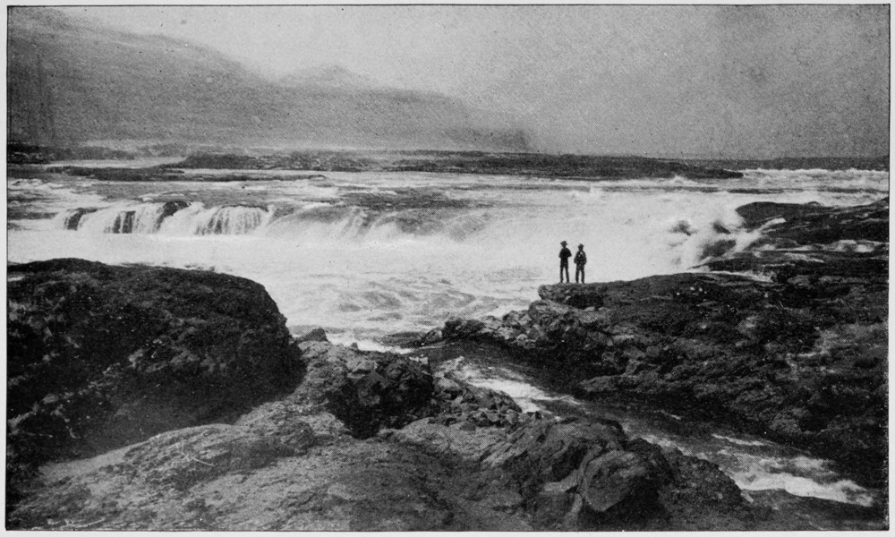
THE GREAT DALLES—COLUMBIA RIVER.