Volume 4 — CHAPTER XI. ANTIQUITIES OF ARIZONA AND NEW MEXICO.
Reading edition
Area enclosed by the Gila, Rio Grande del Norte, and Colorado—A Land of Mystery—Wonderful Reports and Adventures of Missionaries, Soldiers, Hunters, Miners, and Pioneers—Exploration—Railroad Surveys—Classification of Remains—Monuments of the Gila Valley—Boulder-Inscriptions—The Casa Grande of Arizona—Early Accounts and Modern Exploration—Adobe Buildings—View and Plans—Miscellaneous remains, Acequias, and Pottery—Other Ruins on the Gila—Valley of the Rio Salado—Rio Verde—Pueblo Creek—Upper Gila—Tributaries of the Colorado—Rock-Inscriptions, Bill Williams Fork—Ruined Cities of the Colorado Chiquito—Rio Puerco—Lithodendron Creek—Navarro Spring—Zuñi Valley—Arch Spring—Zuñi—Ojo del Pescado—Inscription Rock—Rio San Juan—Ruins of the Chelly and Chaco Cañons—Valley of the Rio Grande—Pueblo Towns, Inhabited and in Ruins—The Moqui Towns—The Seven Cities of Cíbola—Résumé, Comparisons, and Conclusions.
Crossing the boundary line between the northern and southern republics, and entering the territory of the Pacific United States, I shall present in the present chapter all that is known of antiquities in Arizona and New Mexico. An area approximating somewhat the form of a right-angle triangle, with a base of four hundred miles and a perpendicular of three hundred, includes all the remains in this region. The valley of the Rio Gila, with those of its tributary streams, is the southern boundary, or base, stretching along the thirty-third parallel of latitude; the Rio Grande del Norte, flowing southward between the one hundred and sixth and one hundred and seventh meridians, forms with its valley the eastern limit or perpendicular; while on the north and west the region is bounded by the Rio Colorado as a hypothenuse, albeit a very winding one. The latter river might, however, be straightened, thus improving materially the geometrical symmetry of my triangle, without interfering much with ancient remains, as will be seen when the relics of the Colorado section are described.
The face of the country is made up of fertile valleys, precipitous cañons, rugged mountains, and desert table-lands, the latter predominating and constituting a very large portion of the area. Arizona and New Mexico since first they became known to the outside world, have always had, as they still have, more or less of the mysterious connected with them. Here have been located for over three hundred years the wonderful peoples, marvelous cities, extensive ruins, mines of untold wealth, unparalleled natural phenomena, savages of the most bloodthirsty and merciless character, and other marvels, that from the narratives of adventurers and missionaries have found their way into romance and history. This was in a certain sense the last American stronghold of the mysterious as connected with the aborigines, where the native races yet dispute the progress of a foreign civilization.
And the wondrous tales of this border land between civilization and savagism, always exaggerated, had nevertheless much foundation in fact. The Pueblo tribes of New Mexico and the Moquis of Arizona are a wonderful people when we consider the wall of savagism which envelopes them; their towns of many-storied structures are better foundations than usually exist for travelers' tales of magnificent cities; ruins are abundant, showing that the pueblo nations were in the past more numerous, powerful, and cultured, than Europeans have found them; rich mines are now worked, and yet richer ones are awaiting development; few greater natural curiosities have been seen in America than the cañon of the Colorado, with perpendicular sides in some places a mile in height; and the Apaches are yet on the war-path, making a trip through the country much more dangerous now than at the time when the Spaniards first visited it.
Although a large part of these states is still in the possession of the natives, and no official or scientific commission has made explorations which were especially directed to its antiquarian treasures, yet the labors of the priest, hunter, immigrant, Indian fighter, railroad surveyor, and prospector, have left few valleys, hills, or cañons, mountain passes or desert plains unvisited. While it is not probable that all even of the more important ruins have been seen, or described, we may feel very sure, here as in Yucatan, from the uniformity of such monuments as have been brought to light, that no very important developments remain to be made respecting the character, or type, of the New Mexican remains.
EXPLORATION OF NEW MEXICO.
This country was first visited by the Spaniards in the middle of the sixteenth century. The part known to them as New Mexico, and to which their efforts as conquistadores and missionaries were particularly directed, was the valley of the Rio Grande and its tributary streams, but the whole district was frequently crossed and recrossed by the padres down to the latter part of the seventeenth century. Reports of large cities and powerful nations far in the north reached Mexico through the natives as early as 1530; Cabeza de Vaca, ship-wrecked on the coast of the Mexican gulf, wandered through the regions south of and near New Mexico, in 1535-6; roused by the shipwrecked soldier's tale, Fr Marco de Niza penetrated at least into Arizona from Sinaloa in 1539, and was followed by Vasquez de Coronado, who reached the Pueblo towns on the Rio Grande in 1540; Antonio de Espejo followed the course of the great river northward to the Pueblos in 1583, and in 1598 New Mexico was brought altogether under Spanish rule by Juan de Oñate. In 1680 the natives threw off the yoke by revolt, but were again subdued fifteen years later, and the Spaniards retained the power, though not always without difficulty until 1848, when the territory came into the possession of the United States. The archives of the missions are said to have been for the most part destroyed in the revolt of 1680, and consequently their history previous to that date is only known in outline; since 1680 the annals are tolerably clear and complete. The diaries of the Spanish pioneers have been, most of them, preserved in one form or another, and show that the authors visited many of the ruins that have attracted the attention of later explorers, and also that they found many of the towns inhabited that now exist only as ruins. Their accurate accounts of towns still standing and inhabited attest, moreover, their general veracity as explorers.
It is, however, to the explorations undertaken under the authority of the United States government, for the purpose of surveying a practicable route for an interoceanic railroad, and also to establish a boundary line between American and Mexican territory, that we owe nearly all our accurate descriptions of the ancient monuments of this group. These exploring parties, as well as the military expeditions during the war with Mexico, were accompanied by scientific men and artists, whose observations were made public in their official reports, together with illustrative plates. They generally followed the course of the larger rivers, but the ruins discovered by them show a remarkable similarity one to another, and consequently the reports of trappers and guides respecting remains of similar type on the smaller streams, may be generally accepted as worthy of more implicit confidence than can generally be accorded to such reports.
In this division of Pacific States antiquities, which may be spoken of as the New Mexican group, we shall find, 1st, the remains of ancient stone and adobe buildings in all stages of disintegration, from standing walls with roofs and floors to shapeless heaps of débris or simple lines of foundation-stones; 2d, anomalous structures of stone or earth, the purpose of which, either by reason of their advanced state of ruin or of the slight attention given them by travelers, is not apparent; 3d, traces of aboriginal agriculture in the shape of acequias and zanjas, or irrigating canals and ditches; 4th, pottery, always in fragments; 5th, implements and ornaments of stone and shell, not numerous; and 6th, painted or engraved figures on cliffs, boulders, and the sides of natural caverns.
MOUTH OF THE COLORADO.
About the mouth of the Colorado there are no authentic remains of aboriginal work dating back beyond the coming of the Spaniards, although Mr Bartlett found just below the mouth of the Gila traces of cultivation, which seemed to him, judging from the growth of trees that covered them, not to be the work of the present tribes in the vicinity. I find also an absurd newspaper report—and no part of the Pacific States has been more prolific of such reports than that now under consideration—of a wonderful ruined city of hewn stone somewhere about the head of the Gulf of California. This city included numerous dwellings, circular walls of granite, sculptured hieroglyphics, and seven great pyramids, not unlike the famous Central American cities of Palenque and Copan. Some rude figures scratched or painted on the surface of a boulder, seen by a traveler, have been proved by experience to be ample foundation for such a rumor.[XI-1]
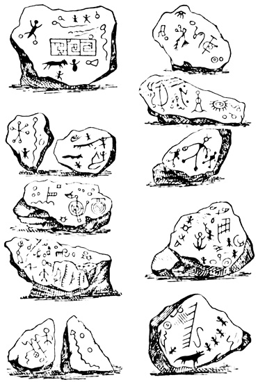
Boulder-Sculptures on the Gila.
ROCK-INSCRIPTIONS OF THE GILA.
Ascending the Rio Gila eastward from its junction with the Colorado, for some two hundred miles we find nothing that can be classed with ancient monuments except natural heaps of large boulders at two points, the flat sides of which are "covered with rude figures of men, animals, and other objects of grotesque forms, all pecked in with a sharp instrument." The accompanying cut shows some of these boulder-sculptures as they were sketched by Bartlett in 1852. Some of them seemed of recent origin, while many were much defaced by exposure, and apparently of great age. The newer carvings in some cases extend over the older ones, and many are found on the under side of the rocks, where they must have been executed before they fell to their present position. The locality of the sculptured rocks is shown on the map; the first is about fifty miles east of Fort Yuma, and the second twenty miles west of the big bend of the Gila, both on the south bank. Two additional incised figures are given in the following cut from Froebel's sketches, since the author thinks that Bartlett may have selected his specimens with a view to strengthen his theory that the figures are not hieroglyphics with a definite meaning.[XI-2]
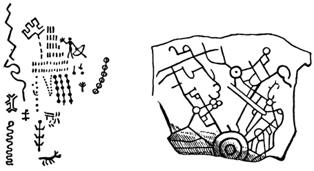
Boulder-Sculptures on the Gila.
Between the Pima villages and the junction of the San Pedro with the Gila, stands the most famous ruin of the whole region—the Casa Grande, or Casa de Montezuma, which it is safe to say has been mentioned by every writer on American antiquity. Coronado during his trip from Culiacan to the 'seven cities' in 1540, visited a building called Chichilticale, or 'red house,' which is supposed with much reason to have been the Casa Grande. The only account of Coronado's trip which gives any description of the building is that of Castañeda, who says, "Chichilticale of which so much had been said [probably by the guides or natives] proved to be a house in ruins and without a roof; which seemed, however, to have been fortified. It was clear that this house, built of red earth, was the work of civilized people who had come from far away." "A house which had long been inhabited by a people who came from Cíbola. The earth in this country is red. The house was large; it seemed to have served as a fortress."[XI-3]
Father Kino heard of the ruin while visiting the northern missions of Sonora in the early part of 1694. He was at first incredulous, but the information having been confirmed by other reports of the natives, he visited the Casa Grande later in the same year, and said mass within its walls. Since Kino was not accompanied at the time by Padre Mange, his secretary, who usually kept the diary of his expeditions, no definite account resulted from this first visit.[XI-4]
In 1697, however, Padre Kino revisited the place, in company this time with Mange, who in his diary of the trip wrote what may be regarded as the first definite description.[XI-5]
CASA GRANDE OF THE GILA.
Padre Jacobo Sedelmair visited the Casa Grande in 1744, but in his narrative he copies Mange's account. He went further, however, and discovered other ruins.[XI-6]
AUTHORITIES ON THE CASA GRANDE.
Lieut C. M. Bernal seems to have been military commandant in Kino's expedition, and he also describes the ruin in his report.[XI-7] Padres Garcés and Font made a journey in 1775-6, under Capt. Anza, to the Gila and Colorado valleys, and thence to the missions of Alta California and the Moqui towns. Both mention the ruin in their diaries, the latter giving quite a full account. I know not if Padre Font's diary has ever been printed, but I have in my collection an English manuscript translation from the original in the archives at Guadalajara,—perhaps the same copy from which Mr Bartlett made the extracts which he printed in his work.[XI-8] Font's plan is not given with the translation, but in Beaumont's Crónica de Mechoacan, a very important work never published, of which I have a copy made from the original for the Mexican Imperial Library of Maximilian, I find a description of the Casa Grande, which appears to have been quoted literally from Font's diary, and which also contains the ground plan of the ruined edifice. I shall notice hereafter its variations from the plan which I shall copy.[XI-9] A brief account was given in the Rudo Ensayo, written about 1761, and by Velarde in his notice of the Pimería, written probably toward the close of the eighteenth century; but neither of these descriptions contained any additional information, having been made up probably from the preceding.[XI-10]
Finally the Casa Grande has been visited, sketched, and described by Emory and Johnston, connected with Gen. Kearny's military expedition to California in 1846; by Bartlett with the Mexican Boundary Commission in 1852; and by Ross Browne in 1863.[XI-11]
The descriptions of different writers do not differ very materially one from another, Bartlett's among the later, and Font's of the earlier accounts being the most complete. From all the authorities I make up the following description, although the extracts which I have already given include nearly all that can be said on the subject. The Casa Grande stands about two miles and a half south of the bank of the Gila;—that is all the early writers call the distance about a league; Bartlett and Emory say nothing of the distance, and Ross Browne says it is half an hour's ride. The Gila valley in this region is a level bottom of varying width, with nearly perpendicular banks of earth. Opposite the ruin the bottom is about a mile wide on the southern bank of the river, and the ruin itself stands on the raised plateau beyond, surrounded by a thick growth of mesquite with an occasional pitahaya. The height and nature of the ascent from the bottom to the plateau at this particular point are not stated; but from the fact that acequias are reported leading from the river to the buildings, it would seem that the ascent must be very slight and gradual.
The appearance of the ruins in 1863 is shown in the cut as sketched by Ross Browne. Other sketches by Bartlett, Emory, and Johnston, agree very well with the one given, but none of them indicate the presence of the mesquite forest mentioned in Mr Bartlett's text. The material of the buildings is adobe,[XI-12] that is, the ordinary mud of the locality mixed with gravel. Most writers say nothing of its color, although Bernal in 1697 pronounced it 'white clay,' and Johnston also says it is white, probably with an admixture of lime, which, as he states, is abundant in the vicinity. Mr Hutton, a civil engineer well acquainted with the ruins, assured Mr Simpson that the surrounding earth is of a reddish color, although by reason of the pebbles the Casa has a whitish appearance in certain reflections. This matter of color is of no great importance except to prove the identity of the building with Castañeda's Chichilticale, which he expressly states to have been built of red earth.[XI-13] The material instead of being formed into small rectangular or brick-shaped blocks, as is customary in all Spanish American countries to this day, seems in this aboriginal structure to have been molded—perhaps by means of wooden boxes—and dried where it was to remain in the walls, in blocks of varying size, but generally four feet long by two feet in width and thickness. The outer surface of the walls was plastered with the same material which constituted the blocks, and the inner walls were hard-finished with a finer composition of the same nature, which in many parts has retained its smooth and even polished surface. Adobe is a very durable building-material, so long as a little attention is given to repairs, but it is really wonderful that the walls of the Casa Grande have resisted, uncared for, the ravages of time and the elements for over three hundred years of known age, and of certainly a century—perhaps much more—of pre-Spanish existence.
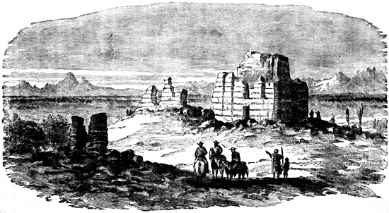
Casa Grande of the Gila.
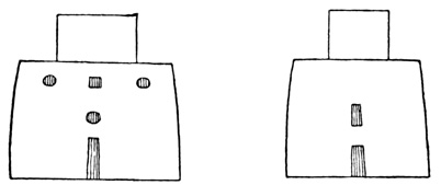
The buildings that still have upright walls are three in number, and in the largest of these both the exterior and interior walls are so nearly perfect as to show accurately not only the original form and size, but the division of the interior into apartments. Its dimensions on the ground are fifty feet from north to south, by forty feet from east to west. The outer wall is about five feet thick at the base, diminishing slightly towards the top, in a curved line on the exterior, but perpendicular on the inside.[XI-14] The interior is divided by partition walls, slightly thinner than the others, into five apartments, as shown in the accompanying ground plan taken from Bartlett. Font's plan given by Beaumont agrees with this, except that additional doors are represented at the points marked with a dot, and no doorway is indicated at a. The three central rooms are each about eight by fourteen feet, and the others ten by thirty-two feet, as nearly as may be estimated from Bartlett's plan and the statements of other writers.[XI-15] The doors in the centre of each façade are three feet wide and five feet high, and somewhat narrower at the top than at the bottom, except that on the western front, which is two by seven or eight feet. There are some small windows, both square and circular in the outer and inner walls. The following cut shows an elevation of the side and end, also from Bartlett.[XI-16]
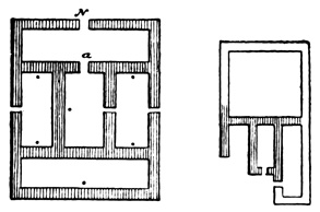
Ground Plan of the Casa Grande.
Elevations of the Casa Grande.
Remains of floor timbers show that the main walls were three stories high, or, as the lower rooms are represented by Font as about ten English feet high, about thirty feet in height; while the central portion is eight or ten feet—probably one story—higher. Mr Bartlett judged from the mass of débris within that the main building had originally four stories; but as the earliest visitors speak of three and four stories—some referring to the central, others apparently to the outer portions—there would seem to be no satisfactory evidence that the building was over forty feet high, although it is possible that the outer and inner walls were originally of the same height. Respecting the arrangement of apartments in the upper stories, there is of course no means of judging, all the floors having fallen. There may, however, have been additional partition walls resting on the floors, and these may have helped to make up the débris noticed by Mr Bartlett. The floors were evidently supported by round timbers four or five inches in diameter, inserted in the walls and stretching across the rooms at regular intervals. The holes where the beams were placed, and in many cases the ends of the beams themselves are still visible. At the time of Padre Kino's visit one floor in an adjoining ruin was still perfect, and was formed by cross-sticks placed upon the round floor-timbers and covered with a thick cake of mud, or adobe.[XI-17] No marks of any cutting instrument were noticed by any visitor except Mr Browne, who says "the ends show very plainly marks of the blunt instrument with which they were cut—probably a stone hatchet."[XI-18] The timbers, of cedar, or sabino, show by their charred ends that the interior was ruined by fire; and Johnston found other evidences that the walls had been exposed to great heat.[XI-19] Nothing seems more natural than that the building should have been burned by some band of Apaches. No traces of stairways have been found even by the earliest visitors; so that the original means of communication with the upper stories may be reasonably supposed to have been wooden ladders, still used by the Pueblo natives in buildings not very unlike what this must originally have been. Mr Bartlett and also Johnston found and sketched some rude figures painted in red lines on the smooth wall of one apartment, but which had disappeared at the time of Mr Browne's visit.
The descriptions of successive explorers show clearly the gradually increasing effects of time and the elements on this ruin; from Browne's sketch it would seem that the walls, undermined at the base by the yearly rains, as is always the case with neglected adobe structures, must soon fall; although I learned from a band of Arizona natives who visited San Francisco in 1873 that the Casa was still standing. When the adobe walls have once fallen, they will require but one or two seasons to crumble and become reduced to a shapeless mound of mud and gravel; as has been the case with most of the eleven other buildings reported here by the first comers, and the existence of which there is no reason to doubt.
Of the additional casas seen by Kino and others no particular description was given, save that Font describes one of them as measuring twenty-six by eighteen feet on the ground. Only two of them show any remains of standing walls, one on the south-west and the other on the north-east of the Casa Grande. The standing portions of the former seemed to indicate a structure similar in plan to the chief edifice, although much smaller; the latter is of still smaller dimensions and its remains convey no idea of its original form. "In every direction," says Mr Bartlett, "as far as the eye can reach, are seen heaps of ruined edifices, with no portions of their walls standing," and Mange, Kino, and Font observed also shapeless heaps covering the plain for a distance of two leagues.
Father Font found "ruins indicating a fence or wall which surrounded the house and other buildings," mentioning a ruin in the south-west angle which had divisions and an upper story. This corner structure may be the same that has been mentioned as standing south-west of the Casa Grande, and Font very likely mistook the heaps of fallen houses for the remains of a wall, since no such wall was seen by Kino and Mange. The dimensions of this supposed wall, four hundred and twenty feet from north to south, and two hundred and sixty feet from east to west, were erroneously applied by Arricivita and Humboldt, followed by others, to the Casa Grande itself, an error which has given a very exaggerated idea of the size of that edifice.[XI-20]
Traces of acequias are mentioned by all as occurring frequently in the vicinity, especially in the Gila bottom between the ruins and the Pima villages. No plan or accurate description of these irrigating works has been given. Probably they were simple shallow ditches in the ground, still traceable at some points. Mange describes the main canal as twenty-seven feet wide, ten feet deep, capable of carrying half the water of the Gila, and extending from the river for a circuit of three leagues round the ruins. Considering the general conformation of the bottom and plateau in this part of the Gila valley, it seems impossible that a canal ten, or even twenty, feet deep could have reached the level of the river, or that so grand an acequia should have escaped the notice of later explorers.
MISCELLANEOUS REMAINS.
The miscellaneous remains near the Casa Grande, besides the mounds formed by fallen houses, the irrigating ditches, and the fragments of pottery strewn over the adjacent country in the greatest profusion, are two in number. The first is a circular embankment, three hundred feet in circumference, situated about six hundred feet north-west from the chief ruin. Its height and material are not stated, but it is undoubtedly of the surrounding earth. Johnston considers it a filled-up well; while Bartlett pronounces the circle a simple corral, or enclosure for stock, although of course it could not have been built in aboriginal times for such a purpose. The second monument is only a few yards north of the circle, and is described by Johnston, the only one who mentions its existence, as a terrace measuring about three hundred by two hundred feet and five feet high. Resting on the terrace is a pyramid only eight feet high, but having a summit platform seventy-five feet square, affording from the top a broad view up and down the valley. A more complete survey of this pyramid would be very desirable, not that there is any reason to question Mr Johnston's reliability as an explorer, but because, as will be seen, this mound, if it be not like the rest, formed by fallen adobe walls, together with the circular embankment, present a marked contrast to all other monuments of the New Mexican group.[XI-21]
Sedelmair and Velarde speak rather vaguely of a reservoir, or tank, six leagues southward of the Gila, which was one hundred and ten by one hundred and sixty-five feet, with walls of adobe 'or of masonry.'[XI-22]
A few miles further up the river, westward from the Casa Grande, and on the opposite or northern side Padre Kino's party saw a ruined edifice, and three men were sent across to examine it. They found some walls over three feet thick still standing, and other heaps of ruins in the vicinity showing that a large town had once stood on the site. Emory found there only a "pile of broken pottery and foundation stones of the black basalt, making a mound about ten feet" high.[XI-23] Still farther west, near the Pima villages, Johnston found another circular enclosure, and also what he calls a mound, ninety by a hundred and fifty feet, and six feet high, having a low terrace of sixty by three hundred feet on the eastern side, all covered with loose basaltic rocks, dirt, and pottery. I consider it not impossible that this mound was formed by the walls of a building which assumed a symmetrical shape in falling.[XI-24] Sedelmair speaks of a group of ruins on the southern bank of the river, twelve leagues below the Casa Grande; but no later writer mentions such remains.[XI-25]
REMAINS IN THE SALADO VALLEY.
The principal tributary of the Gila from the north is the Rio Salado, or Salinas, the mouth of which is below the Casa Grande, and into which, near its mouth, flows the Rio Verde, or San Francisco. The Spaniards seem not to have ascended these streams; or at least not to have discovered any ruins in their valleys. The guides, however, reported to the missionaries the existence of ruins on the Rio Verde, in the north, similar to those on the Gila.[XI-26] Sedelmair also discovered in 1744, the ruins of a large edifice and several smaller ones in the space between the Gila and Salado.[XI-27] Velarde speaks of ruined buildings of three stories at the junction of the rivers Salado and Gila, and other remains at the junction of the Salado and Verde.[XI-28]
A guide reported to Emory a casa in the Salado valley, complete except the floors and roof, of large dimensions, with glazed walls, and the imprint of a naked foot in the adobe.[XI-29] One of four stone axes shown in a cut to be given later, was found in this valley and sketched by Whipple.[XI-30] The Salado ruins between the Gila and Verde, on the south bank, about thirty-five miles from the mouth, were examined by Mr Bartlett. They are built on the plateau beyond the river bottom, and are exclusively of adobe. They are very numerous, but consist for the most part of shapeless heaps indicating the location of buildings and long lines of walls. In only two instances did portions of standing walls remain; being in one case the ruins of an adobe building over two hundred feet long and from sixty to eighty feet wide, facing the cardinal points, and, so far as could be judged by the débris, three or four stories high; the others were about two hundred yards distant, and represented a smaller structure. There are traces of a wall which appears to have surrounded the larger building. From the top of the principal pile, similar heaps of ruins may be seen in all directions, including a range of them running north and south at a distance of about a mile eastward. The latter were not visited, but were said by the natives to be similar in every respect to the others. A small circular enclosure, whose dimensions are not given, was seen among the ruins, and there were also excavations along the sides of some of the heaps, as if they had furnished the material for the original structures. In the river bottom irrigating canals are of frequent occurrence, one of them from twenty to twenty-five feet wide and four to five feet deep, formed by cutting down the bank of the plateau, along which it extends for many miles. The whole vicinity of the ruins, as in the Gila Valley, is strewn with fragments of earthen ware. These earthen ware fragments are of a very uniform character throughout the New Mexican region, and will be illustrated in another part of this chapter.[XI-31]
Trappers and natives report that these remains continue indefinitely up the valleys of both the Salado and Verde. Mr Leroux, who served as guide to several of the United States military expeditions, passed up the Verde valley in 1854 on his way from the Gila to the Colorado Chiquito, keeping a diary, a part of which has been printed.[XI-32] He claims to have found the river banks covered in many places with ruins of stone buildings and broken pottery. The walls were of solid masonry still standing from ten to twenty feet high in two stories, three feet thick and from fifty to seventy-five feet long. Except in material the structures were not unlike the Casa Grande of the Gila, and were generally situated in the most fertile parts of the valley, surrounded by traces of acequias; although in one instance the ruins of a town were ten miles from the nearest water. A complete change of building material within so short a distance is somewhat extraordinary, but there is no other reason to doubt the accuracy of this report. These ruins are not very far from Prescott in the north, and Fort McDowell in the south, and I regret not having been able to obtain from officers in the Arizona service the information which they must have acquired respecting those remains, if they actually exist, during the past ten or fifteen years.[XI-33]
PUEBLO CREEK AND THE UPPER GILA.
Whipple describes some ruins discovered by him in 1854 on Pueblo Creek and other small streams which form the head waters of the Verde. They consist of what seem to have been two fortified settlements, and a third separate fortification. The first was an irregular stone enclosure on the top of a hill three or four hundred feet high. The walls were from eight to ten feet high, and the interior was divided by partition walls five feet thick into different compartments. On the slopes of the hill were traces of adobe walls with the usual abundance of broken pottery. The second was located in a fertile spot on a fork of the Pueblo Creek, and consisted of a mass of stones, six feet thick and several feet high, forming a square enclosure "five paces in the clear." The third work is situated about eight miles further west, and commands what is known as Aztec Pass. It is an enclosure one hundred feet long, twenty-five feet wide at one end and twenty at the other, the walls being four feet thick and five feet in height. In the absence of any definite statement on the subject these northern fortifications are presumed to be of rough, or unhewn, stones without mortar.[XI-34]
Typical Plan of Gila Structures.

Plan of a Gila Structure.
LABYRINTH ON THE GILA.
Plan of Labyrinth on the Gila.
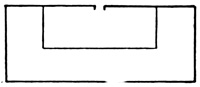
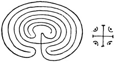
From the mouth of the San Pedro, which joins the Gila about forty miles eastward of the Casa Grande, up the Gila valley eastward, ruins of ancient edifices are frequently found on both banks of the river. Emory says "wherever the mountains did not impinge too close on the river and shut out the valley, they were seen in great abundance, enough, I should think, to indicate a former population of at least one hundred thousand; and in one place there is a long wide valley, twenty miles in length, much of which is covered with the ruins of buildings and broken pottery." The remains consist uniformly of lines of rough amygdaloid stones rounded by attrition, no one of which remains upon another, apparently the foundations upon which were erected adobe walls that have altogether disappeared. The plan of the buildings as indicated by their foundations was generally rectangular; many of them were very similar to the modern Spanish dwellings, as shown in the accompanying cut; but a few were circular or of irregular form. One of them just below the junction of the Santo Domingo, on an isolated knoll, was shaped as in the following cut, with faces of from ten to thirty feet. Besides the traces of what seem to be dwellings, there were also observed, an enclosure or circular line of stones, four hundred yards in circumference; a similar circle ninety yards in circumference with a house in the centre; an estufa with an entrance at the top; some well-preserved cedar posts; and some inscribed figures on the cliffs of an arroyo, similar to those lower down the river, of which cuts have been given. The native Pimas reported to the Spaniards in early times the existence of a building far up the Gila, the labyrinthine plan of which they traced on the sand, as shown in the cut. Emory and Johnston found these traces of aboriginal towns in at least twelve places on the Gila above the San Pedro, the largest being at the mouth of a stream flowing from the south-east, probably the Santo Domingo. I find no mention of ruins on any of the smaller tributaries of the Gila above the Casa Grande, though it seems very probable that such ruins may exist, similar to those on the main stream. A painted stone, a beaver-tooth, and marine shells were the miscellaneous relics found by Johnston among the ruins, besides the usual large quantities of broken pottery. Emory speaks of a few ornaments, principally immense well-turned beads of the size of hens' eggs, also fragments of agate and obsidian. The latter explorer gives a plate of rock-hieroglyphics of doubtful antiquity, and Froebel also sketched certain inscriptions on an isolated rock. Six or eight perfectly symmetrical and well-turned holes about ten inches deep and six or eight inches wide at the top were noticed, and supposed to have served for grinding corn.[XI-35]
Having presented all that is known of antiquities upon the Gila and its tributaries, I pass to the Colorado, the western and northern boundary of the New Mexican territory. The banks of the Colorado Cañon, for the river forms no valley proper, are for the most part unexplored, and no relics of antiquity are reported by reliable authorities; indeed, from the peculiar nature of this region, it is not likely that any ruins ever, will be found in the immediate vicinity of the river.[XI-36]
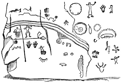
On Bill Williams' Fork there is a newspaper report, resting on no known authority, of walls enclosing an area some eight hundred feet in circumference, still perfect to the height of six or eight feet.[XI-37] The only other traces of the former inhabitants found on this stream are painted cave and cliff pictures or hieroglyphics. Two caves have their walls and the surrounding rocks thus decorated; they are about a mile apart, near the junction of the Santa María, and one of them is near a spring. Many of the inscriptions appear very ancient, and some were painted on cliffs very difficult of access. The cut shows a specimen from the sketches made by Möllhausen. The streak which crosses the cut in the centre, extends to the left beyond the other figures, and only half its length is shown. This streak is red with white borders; the other figures are red, purple, and white.[XI-38]
Rock-Paintings—Bill Williams' Fork.
TRIBUTARIES OF THE COLORADO.
Leaving Bill Williams' Fork, and passing the Pueblo Creek ruins already described, which are not far distant, I follow the routes of Sitgreaves, Ives, and Whipple, north-westward to the Colorado Chiquito, a distance of about one hundred miles, striking the river at a point a hundred miles above its supposed junction with the main Colorado. In this region we again find numerous ruined buildings with the usual scattered pottery, respecting which our knowledge is derived from the explorers just named. The ruins occur at all prominent points, both near the river and away from it towards the west, at intervals of eight or nine miles, the exact location not being definitely fixed. The material employed here is stone, and some of the houses were three stories high. A view of one ruin as sketched by Sitgreaves is shown in the cut. On a rocky eminence were found by Whipple stone enclosures, apparently for defense. According to Mr Sitgreaves the houses resembled in every particular, save that no adobe was used, the inhabited Pueblo towns of New Mexico. His description, like that of Möllhausen and Whipple, would doubtless be much more complete and satisfactory, had they not previously seen the Pueblo towns and other ruins further east. Some of the ruins are far from water, and Sitgreaves suggests that the lava sand blown from the neighboring mountains may have filled up the springs which originally furnished a supply.
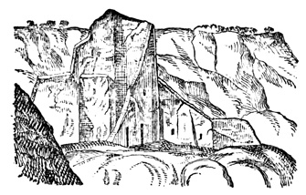
Ruin on the Colorado Chiquito.
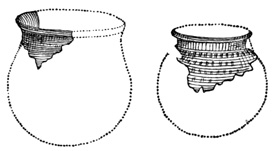
Vases from the Colorado Chiquito.
The cut from Whipple shows two vases found here, restored from fragments. This is one of the rarest kinds of pottery found in the region, and is said by Whipple not to be manufactured by any North American Indians of modern times. It is seldom colored, the ornamentation being raised or indented, somewhat like that on molded glassware, and of excellent workmanship. The material is light-colored and porous, and the vases are not glazed. The ordinary fragments of earthen ware found on this river will be represented in another part of this chapter. Some very rude and simple rock-inscriptions were noticed, and a newspaper writer states that the names of Jesuit priests who visited the place in the sixteenth century are inscribed on the rocks. Some additional and not very well-founded reports of antiquities are given in a note.[XI-39]
REMAINS ON THE COLORADO CHIQUITO.
At a bend in the river, about forty miles above the ruins last mentioned, are the remains of a rectangular stone building, measuring one hundred and twenty by three hundred and sixty feet, and standing on an isolated sandstone hill. The walls are mostly fallen, but some of the standing portions are ten feet thick, and seem to contain small apartments. Many pine timbers are scattered about in good preservation, and two posts twelve feet in height still remain standing.[XI-40]
Some twenty-five miles still farther up the Rio Puerco flows into the Colorado Chiquito from the north-east, and at the junction of the two streams Möllhausen noticed some remains which he does not describe.[XI-41] Twelve miles up the Puerco valley, on the banks of a small tributary, called Lithodendron Creek, were scattered fragments of pottery, and remains of stone houses, one of the walls extending several feet below the present surface of the ground. Still farther up the Puerco and five miles south of the river, at Navajo Spring, scattered pottery and arrow-heads are the only remaining trace of an aboriginal settlement, no walls being visible. On a neighboring hill, however, was noticed a circular depression in the earth forty paces in diameter. The cut from Möllhausen represents some of the aboriginal inscriptions on Puerco River.[XI-42]
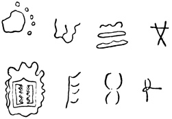
Rock-Inscriptions on Rio Puerco.
REMAINS ON THE RIO ZUÑI.
Forty or fifty miles farther south-east, the Colorado Chiquito receives the waters of the Rio Zuñi, flowing from the north-east in a course nearly parallel to that of the Puerco. Aboriginal inscriptions and pictures are found on the sandstone cliffs which border on the stream wherever a smooth surface is presented, but no buildings occur for a distance of about fifty miles, until we come to within eight miles of the Pueblo town of Zuñi, where the table-lands about Arch Spring are covered with ruins, which were seen, although not described, by Sitgreaves and Whipple. All the ruins of the Zuñi valley seem, however, to be of the same nature—stone walls laid in mud mortar, and in a very dilapidated condition. The cut from Whipple shows also a sample of the rock-inscriptions about Arch Spring.[XI-43] Zuñi is a Pueblo town still inhabited, and I shall have something further to say of it in connection with the Pueblo towns of the Rio Grande and its tributaries, for the purpose of comparing the inhabited with the ruined structures.
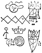
Rock-Inscriptions at Arch Spring.
Zuñi Vases.
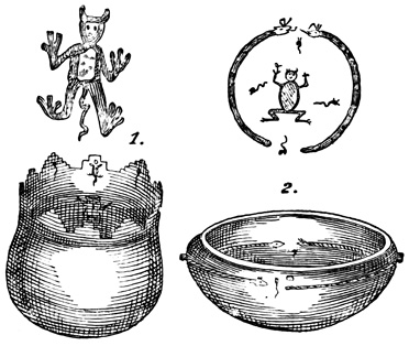
Two or three miles south-east of Zuñi, on the south side of the river, is an elevated level mesa, about a mile in width, bounded on every side by a precipitous descent of over a thousand feet to the plain below. The mesa is covered with a growth of cedar, and in one part are two sandstone pillars of natural formation, which from certain points of view seem to assume human forms. Among the cedars on the mesa, "crumbling walls, from two to twelve feet high, were crowded together in confused heaps over several acres of ground." The walls were constructed of small sandstone blocks laid in mud mortar, and were about eighteen inches thick. They seemed, however, to rest on more ancient ruins, the walls of which were six feet in thickness. At various points on the winding path, by which only the top can be reached, there are stone battlements which guard the passage. A supposed altar was found in a secluded nook near the ruins, consisting of an oval excavation seven feet long, with a vertical shaft two feet high at one end, a flat rock, and a complicated arrangement of posts, cords, feathers, marine shells, beads, and sticks, only to be understood from a drawing, which I do not reproduce because the whole altar so-called is so evidently of modern origin and use. These ruins are commonly called Old Zuñi, and were doubtless inhabited when the Spaniards first came to the country.[XI-44] The cut from Whipple shows two vases found at what is called a sacred spring near Zuñi. Of the first the discoverer says: "the material is a light-colored clay, tolerably well burnt, and ornamented with lines and figures of a dark brown or chocolate color. A vast amount of labor has been spent on decorating the unique lip. A fine borderline has been drawn along the edge and on both sides of the deep embattled rim. Horned frogs and tadpoles alternate on the inner surface of the turrets, while one of the latter is represented on the outside of each. Larger frogs or toads are portrayed within the body of the vessel." One of these figures is presented in the cut enlarged. The second vase is five inches deep, ten inches in diameter at the widest part, and eight inches at the lips. Both outer and inner surface bear a white glazing, and there are four projections of unknown use, one on each side. The decorations are in amber color, and the horned or tufted snakes, shown above the vase, are said to be almost unique in America.[XI-45]
OJO DEL PESCADO.
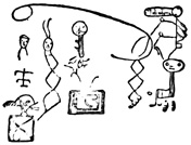
At and near some springs called Ojo del Pescado, on the head-waters of this stream, some twelve miles above Zuñi, there are at least four or five ruined structures, or towns. They are similar in character to the other ruins. Two of them near the spring have an elliptical shape, as shown by the lines of foundation-stones, and are from eight hundred to a thousand feet in circumference. The houses seem to have been built around the periphery, forming a large interior court. These towns are so completely in ruins that nothing can be ascertained of the details of their construction, except their general form, and the fact that they were built of stones and mud. About a thousand yards down the river from the springs are ruins covering a space one hundred and fifty by two hundred yards, and in much better preservation than those mentioned, though of the same nature. The material was flat stones and cement, and the walls are standing in places to the height of two stories. Möllhausen tells us that the roofs and fire-places were still standing at the time of his visit. Simpson describes a ruin as being two miles below the spring, and which may possibly be the same last mentioned. The buildings were originally two stories high and built continuously about a rectangular area three hundred by four hundred feet. In the interior of the enclosed court was seen a square estufa, twelve by eighteen feet, and ten feet high, with the roof still perfect. The cut shows some of the rock-inscriptions at Ojo del Pescado.[XI-46]
Rock-Inscriptions—Ojo del Pescado.
EL MORO, OR INSCRIPTION ROCK.
Inscriptions—El Moro.
Plan of El Moro.
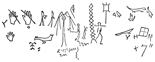
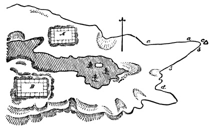
About eighteen miles south-east of the sources of the Zuñi River, but belonging as properly in this valley as any other, is a sandstone rock known as Inscription Rock, or to the Spaniards as El Moro, from its form. It is between two and three hundred feet high, with steep sides, which on the north and east are perpendicular, smooth, white, and covered near the base with both Spanish and native inscriptions. Specimens of the latter, as copied by Simpson, are shown in the cut. The former were all copied by the same explorer, but of course have no connection with the subject of this volume: they date back to 1606, but make no reference to any town or ruins upon or about the rock. The ascent to the summit is on the south and is a difficult one. The cut shows a plan of El Moro made by Möllhausen, the locality of the inscriptions being at a and b. The summit area is divided by a deep ravine into two parts, on each of which are found ruins of large edifices. Those on the southern—or, according to Simpson, on the eastern—division, B of the plan, form a rectangle measuring two hundred and six by three hundred and seven feet, standing in some places from six to eight feet high. According to Simpson the walls agree with the cardinal points, but Whipple states the contrary. The walls are faced with sandstone blocks six by fourteen inches and from three to eight inches thick, laid in mud-mortar so as to break joints; but the bulk of the wall is a rubble of rough stones and mud. Two ranges of rooms may be traced on the north and west sides, and the rubbish indicates that there were also some apartments in the interior court. Two rooms measured each about seven by eight feet. A circular estufa thirty-one feet in diameter was also noticed, and there were cedar timbers found in connection with the ruined walls; one piece, fifteen inches long and four inches in diameter was found still in place, and bore, according to Whipple, no signs of cutting tools. The remains across the ravine, A of the plan, are of similar nature and material, and the north wall stands directly on the brink of a precipice, being complete to a height of eight feet. There is a spring furnishing but a small amount of water at the foot of the cliff at d. Fragments of pottery are abundant here as elsewhere.[XI-47]
RUINS OF CHELLY CAÑON.
This completes my account of remains on the Colorado Chiquito, and I pass to the next and last tributary of the Colorado within the territory covered by this chapter—the San Juan, which flows in an eastwardly course along the boundary line between Arizona and New Mexico on the south, and Utah and Colorado on the north. The valley of the main San Juan has been but very slightly explored, but probably contains extensive remains, judging from what have been found on some of its tributaries. Padres Dominguez and Escalante went in 1776 from Santa Fé north-westward to Utah Lake, and noticed several ruins which it is impossible to locate, before crossing the Colorado. I shall have occasion in the following chapter to notice some important ruins lately discovered on the northern tributaries of the San Juan, in the southern part of Colorado and Utah.[XI-48]
The two chief tributaries of the San Juan from the south are the Chelly and Chaco, flowing through deep cañons in the heart of the Navajo country. On both of these streams, particularly the latter, very important ruins have been discovered and described by Mr Simpson, who explored this region in 1849.
The Chelly cañon for a distance of about twenty-five miles is from one hundred and fifty to nine hundred feet wide, from three hundred to five hundred feet deep, and its sides are almost perpendicular. Simpson explored the cañon for eight miles from its mouth, which does not correspond with the mouth of the river. In a branch cañon of a character similar to that of the main stream he found several small habitations formed by building walls of stone and mortar in front of overhanging rocks. Some four miles up the main cañon he saw on a shelf fifty feet high and only accessible by means of ladders a small ruin of stone, much like those on the Chaco yet to be described. Seven miles from the mouth another ruin was discovered on the north side as shown in the cut. It was built partly on the bottom of the cañon, and partly like the one last mentioned, on a shelf fifty feet high with perpendicular sides. The walls measure forty-five by a hundred and forty-five feet, are about eighteen feet high in their present state, and are built of sandstone and mortar, having square openings or windows. A circular estufa was also found in connection with these cliff-dwellings. Fragments of pottery were not lacking, and specimens were sketched by Mr Simpson.[XI-49]
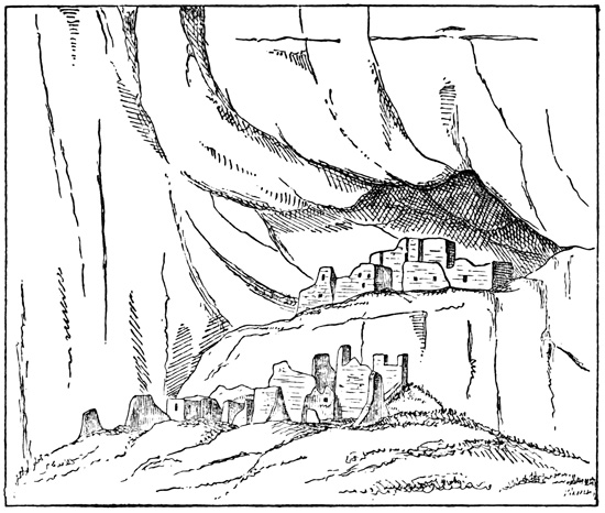
Ruin in the Chelly Cañon.
Eastward from the Chelly, at a distance of about a hundred miles, is the Chaco, a parallel tributary of the San Juan, on which are found ruins perhaps the most remarkable in the New Mexican group. Lieut. Simpson is the only one who has explored this valley, or at least who has left a record of his exploration. The ruins are eleven in number, situated with one exception on the north bank of the stream, within a distance of twenty-five miles in latitude 36° and longitude 108°.
RUINS OF THE CHACO.
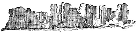
Ruins of the Pueblo Pintado.
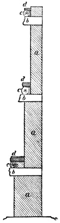
Section of Wall—Chaco Ruins.
The cut shows a general view of the ruin called by the guide Pueblo Pintado, the first one discovered in coming from the south. The name of this ruin, like those of the others, is doubtless of modern origin, being Spanish, and there is little reason to believe that the native names of some of the others are those originally applied to the inhabited towns. The material of all the buildings is a fine hard gray sandstone, to which in some instances exposure to the air has imparted a reddish hue. The blocks are cut very thin, rarely exceeding three inches in thickness. They are laid without mortar very carefully, so as to break joints, and the chinks between the larger blocks are filled with stone plates, sometimes not over one fourth of an inch thick. In one instance, the Pueblo Peñasco Blanco, stones of different thickness are laid, in alternate layers, producing the appearance of a kind of mosaic work, executed with great care and skill, and forming a very smooth surface. The backing and filling of the walls are of irregular and various sized blocks laid in mud, no trace of lime being discoverable. The wall of the Pueblo Pintado was found by excavation to extend at least two feet below the surface of the ground. The walls are between two and three feet thick at the base, but diminish towards the top by a jog of a few inches on the inside at each successive story. The walls of the Pueblo Pintado are still standing in some parts to the height of twenty-five to thirty feet, and are shown by the marks of floor timbers to have had at least three stories. The flooring was supported by unhewn beams from six to eleven inches in diameter—but uniform in the same room—stretching across from wall to wall as in the Gila ruins. Over these beams were placed smaller transverse sticks, which in the Pueblo Pintado seem to have been placed some little distance apart; but in some other ruins where the flooring remained perfect, the transverse sticks were laid close together, the chinks were filled with small stones, and the whole covered with cedar strips, although there was evidence that a coating of mud or mortar was used in some instances; and there was one room where the floor was of smooth cedar boards seven inches wide and three fourths of an inch thick, squarely cut at the sides and ends, and apparently worn smooth by the friction of flat stones. The beams generally bore marks of having been cut off by the use of some blunt instrument. The cut illustrates the manner in which the walls diminish in thickness from story to story, a, a, a; the position of the beams, b, b, b; the transverse poles, c, c, c; and the flooring above, d, d, d.
RUINS OF THE CHACO CAÑON.
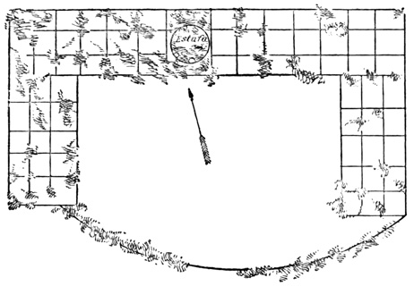
Ground Plan—Pueblo Hungo Pavie.
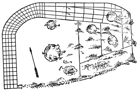
Ground Plan—Pueblo Bonito.
THE PUEBLO BONITO.
The ground plan of the Chaco structures shows three tiers—but in one case at least four tiers—of apartments built round three sides of a courtyard, which is generally rectangular, in some cases has curved corners, and in one building—the Peñasco Blanco—approximates to the form of a circle. The fourth side of the court is in some ruins open, and in others enclosed by a wall extending in a curve from one extremity of the building to the other. The following cuts show the ground plans of two of the ruins, the Pueblo Hungo Pavie, 'crooked nose,' and Pueblo Bonito. The circumference of five of these buildings is respectively eight hundred and seventy-two, seven hundred, seventeen hundred, thirteen hundred, and thirteen hundred feet; the number of rooms still traceable on the ground floor of the same buildings is seventy-two, ninety-nine, one hundred and twelve, one hundred and twenty-four, and one hundred and thirty-nine. These apartments are from five feet square to eight by fourteen feet. A room in the Pueblo Chettro Kettle was seven and a half by fourteen feet, and ten feet high. The walls were plastered with a red mud, and several square or rectangular niches of unknown use were noticed. The supporting beams of the ceiling were two in number, and the transverse poles were tied at their ends with some wooden fibre, and covered with a kind of cedar lathing. Ropes hung from the timbers. A room in the Pueblo Bonito is shown in the cut.
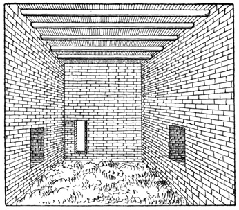
Interior of Room—Pueblo Bonito.
This room is unplastered, and the sides are constructed in the same style as the outer walls. The transverse poles are very small, about an inch in diameter, laid close together, very regular, and resemble barked willow. It was another room in this ruin which had the smooth boards in connection with its ceiling.[XI-50]
The doors by which the rooms communicate with each other and with the courtyard are very small, many of them not exceeding two and a half feet square. There are no doors whatever in the outer walls, and no windows except in the upper stories. The larger size of the windows and of the inner doors indicate that the rooms of the upper stories were larger than below. In some cases the walls corresponding to the second or third stories had no windows. In one case lower story windows were found walled up. The tops, or lintels, of the doors and windows were in some cases stone slabs, in others small timbers bound together with withes, and in a few they are reported to have been formed by overlapping stones very much like the Yucatan arch; a specimen is shown in the cut.
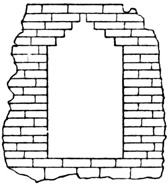
Arch of Overlapping Stones.
The highest walls still standing at the time of Simpson's visit had floor-timbers, or their marks, for four stories, but it is not impossible that some of the buildings may have had originally five or six stories. The outer walls were in every case perpendicular to their full height, showing that the houses were not built in receding terraces, or stories, on the outside, as is the case with many of the inhabited Pueblo towns, and with the Casa Grande on the Gila. There can be no doubt that they were so terraced on the interior or court; at least in no instance were the inner walls sufficiently high to indicate a different arrangement, and it is hardly possible that all the ranges were of the same height, leaving without light most of the thousand rooms which they would contain if built on such a plan. There were no traces of stairways or chimneys seen. The whole number of apartments in the Pueblo Bonito, supposing it to have been built on the terrace plan, must have been six hundred and forty-one. The cut on the next page shows a restoration of one of the Chaco ruins, taken from Mr Baldwin's work, and modeled after a similar one by Mr Kern, a companion of Simpson, although Mr Kern made an error of one story in the height. I have no doubt of the general accuracy of this restoration, and it may be regarded as nearly certain that access to the upper rooms was gained from the court by means of ladders, each story forming a platform before the doors of the one next above.
Each ruin has from one to seven circular structures, called estufas in the inhabited Pueblo towns, sunk in the ground and walled with stone. Several of these are shown in the two ground plans that have been given. They occur both in the courtyards and underneath the rooms. Some were divided into compartments, and one, in the Pueblo Bonito, was sixty feet in diameter and twelve feet deep, being built in two, and possibly three, stories.
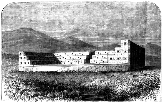
Restoration of Pueblo Hungo Pavie.
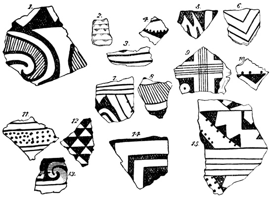
Pottery—Chaco Cañon.
Near some of the larger buildings are smaller detached ruins, of which no particular description is given. In one place there is an excavation in the side of a cliff, enclosed by a front wall of stone and mortar. In another locality there is an isolated elliptical enclosure of stone and mortar, eight by sixteen feet, and divided into two compartments. Near one of the ruins, in the northern wall of the cañon, about twelve feet from the base, are three circular holes two feet in diameter, with smaller ones between them, all in a horizontal line, with a vertical line of still smaller holes leading up the cliff to one of the larger ones. Mr Simpson was unable to explore this singular excavation, and its use is unknown; it may be a room or fortress excavated from the solid rock. There are also some hieroglyphics on the face of the cliff under the holes. The quarries which furnished the stone for some of the buildings were found, but no description of them is given. Hieroglyphics on boulders were found at a few points. The pottery found among the Chaco ruins is illustrated by the cut. Black and red seem to be the only colors employed. The Chaco cañon, although wider than that of the Chelly, is bounded by precipitous sides, and the ruins are generally near the base of the cliff. The Pueblo Pintado is built on a knoll twenty or thirty feet high, about three hundred yards from the river. The buildings do not exactly face the cardinal points.[XI-51]
PUEBLO REMAINS ON THE RIO GRANDE.
I now come to the last division of the present group, the perpendicular of our triangle, the Rio Grande del Norte and its tributaries. This valley, the New Mexico proper of the Spaniards, when first visited in the sixteenth century, was thickly inhabited by an agricultural semi-civilized people, dwelling in towns of stone and mud houses several stories in height. Respecting the number, names, and exact locality of these towns the early accounts are somewhat vague, but many of them can be accurately traced by means of an examination of authorities which would be out of place here. From the first discovery by Cabeza de Vaca, Marco de Niza, and Francisco Vasquez de Coronado, the general history of the country is clear; and we still find the same semi-civilized people living in similar towns under similar institutions, although they, like the towns in which they live, are greatly reduced in number. Some of the inhabited Pueblo towns are known by name, location, and history, to be identical with those which so excited the admiration of the Spaniards; and there is every reason to believe that all are so, except a few that may have been built during the Spanish domination. The inhabited Pueblo towns, or those inhabited during the nineteenth century, are about twenty in number, although authors disagree on this point, some calling Pueblos what others say are merely Mexican towns; but the distinction is not important for my present purpose.[XI-52] The important fact is, that the Spaniard found no race of people in New Mexico which has since become extinct, nor any class of towns or buildings that differed from the Pueblo towns still inhabited.
Besides the towns still inhabited there are many of precisely the same materials and architecture, which are in ruins. Such are Pecos, Quivira, Valverde, San Lázaro, San Marcos, San Cristóbal, Socorro, Senacu, Abó, Quarra, Rita, Poblazon, old San Felipe, and old Zuñi. Some of these were abandoned by the natives at a very recent date; some have ruined Spanish buildings among the aboriginal structures; some may be historically identified with the towns conquered by the first European visitors. These facts, together with the absence of any mention of ruins by the first explorers, and the well-known diminution of the Pueblos in numbers and power, make it perfectly safe to affirm that the ruins all belong to the same class, the same people, and about the same epoch as the inhabited towns. This conclusion is of some importance since it renders it useless to examine carefully each ruin, and the documents bearing on its individual history, and enables the reader to form a perfectly clear idea of all the many structures by carefully studying a few.
While the Pueblo towns cannot be regarded as objects of great mystery, as the work of a race that has disappeared, or as a station of the Aztecs while on their way southward, yet they are properly treated as antiquities, since they were doubtless built by the native races before they come in contact with the Spaniards. They occupy the same position with respect to the subject of this volume as the remains in Anáhuac, excepting perhaps Cholula and Teotihuacan; or rather they have the same importance that the city of Tlacopan would have, had the Spaniards permitted that city to stand in possession of its native inhabitants.
PUEBLO TOWNS OF NEW MEXICO.
An account of the Pueblo buildings has been given in another volume of this work,[XI-53] and I cannot do better here than to quote from good authorities a description of the principal towns, both inhabited and in ruins. Of Taos Mr Abert says, "One of the northern forks of the Taos river, on issuing from the mountains, forms a delightful nook, which the Indians early selected as a permanent residence. By gradual improvement, from year to year, it has finally become one of the most formidable of the artificial strongholds of New Mexico. On each side of the little mountain stream is one of those immense 'adobe' structures, which rises by successive steps until an irregular pyramidal building, seven stories high, presents an almost impregnable tower. These, with the church and some few scattering houses, make up the village. The whole is surrounded by an adobe wall, strengthened in some places by rough palisades, the different parts so arranged, for mutual defence, as to have elicited much admiration for the skill of the untaught engineers." Of the same town Davis says, "It is the best sample of the ancient mode of building. Here there are two large houses three hundred or four hundred feet in length, and about one hundred and fifty feet wide at the base. They are situated upon opposite sides of a small creek, and in ancient times are said to have been connected by a bridge. They are five and six stories high, each story receding from the one below it, and thus forming a structure terraced from top to bottom. Each story is divided into numerous little compartments, the outer tiers of rooms being lighted by small windows in the sides, while those in the interior of the building are dark, and are principally used as store-rooms.... The only means of entrance is through a trap-door in the roof, and you ascend, from story to story, by means of ladders upon the outside, which are drawn up at night." The same writer gives the following cut of Taos.[XI-54]
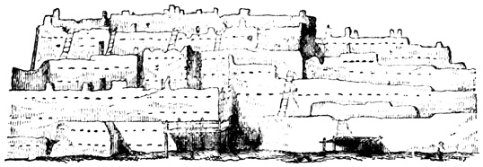
Pueblo of Taos.
The houses of Laguna are "built of stone, roughly laid in mortar, and, on account of the color of the mortar, with which they are also faced, they present a dirty yellowish clay aspect. They have windows in the basement as well as upper stories; selenite, as usual, answers the purpose of window-lights."[XI-55]
"High on a lofty rock of sandstone ... sits the city of Acoma. On the northern side of the rock, the rude boreas blasts have heaped up the sand, so as to form a practical ascent for some distance; the rest of the way is through solid rock. At one place a singular opening, or narrow way, is formed between a huge square tower of rock and the perpendicular face of the cliff. Then the road winds round like a spiral stair way, and the Indians have, in some way, fixed logs of wood in the rock, radiating from a vertical axis, like steps.... At last we reached the top of the rock, which was nearly level, and contains about sixty acres. Here we saw a large church, and several continuous blocks of buildings, containing sixty or seventy houses in each block, (the wall at the side that faced outwards was unbroken, and had no windows until near the top: the houses were three stories high). In front each story retreated back as it ascended, so as to leave a platform along the whole front of the story: these platforms are guarded by parapet walls about three feet high." Ladders are used for first and second stories but there are steps in the wall to reach the roof.[XI-56] Mr Gregg tells us that San Felipe is on "the very verge of a precipice several hundred feet high," but Simpson states that "neither it nor Sandia is as purely Indian in the style of its buildings as the other pueblos."[XI-57]
Santo Domingo "is laid out in streets running perpendicularly to the Rio Grande. The houses are constructed of adobes, (blocks of mud, of greater or less dimensions, sun-dried;) are two stories in height, the upper one set retreatingly on the lower, so as to make the superior covering of the lower answer for a terrace or platform for the upper; and have roofs which are nearly flat. These roofs are made first of transverse logs which pitch very slightly outward, and are sustained at their ends by the side walls of the building; on these, a layer of slabs or brush is laid; a layer of bark or straw is then laid on these; and covering the whole is a layer of mud of six or more inches in thickness. The height of the stories is about eight or nine feet."[XI-58]
"On my visit to the pueblo of Tesuque we entered a large square, around which the dwellings are erected close together, so as to present outwardly an unbroken line of wall to the height of three stories. Viewed from the inner square it presents the appearance of a succession of terraces with doors and windows opening upon them.... This general description is applicable to all the Pueblo villages, however they may differ in size, position, and nature of the ground—some being on bluffs, some on mesas, and most of those in the valley of the Rio Grande on level ground."[XI-59]
Zuñi, "like Santo Domingo, is built terrace-shaped—each story, of which there are generally three, being smaller, laterally, so that one story answers in part for the platform of the one above it. It, however, is far more compact than Santo Domingo—its streets being narrow, and in places presenting the appearance of tunnels, or covered ways, on account of the houses extending at these places over them. The houses are generally built of stone, plastered with mud,"—has an adobe Catholic church.[XI-60]
THE MOQUI TOWNS.
The seven Moqui towns in Arizona, situated in an isolated mountainous region about midway between the Colorado Chiquito and the Chelly cañon, in latitude 35° 50´, and longitude 110° 30´, are very similar to the Pueblo towns of the Rio Grande. They were probably visited by the earliest Spanish explorers, and have a claim to as great an antiquity as any in the whole region. Lieut. Ives visited the Moquis in 1858, and his description is the best extant; from it I quote as follows: "I discovered with a spy-glass two of the Moqui towns, eight or ten miles distant, upon the summit of a high bluff overhanging the opposite side of the valley. They were built close to the edge of the precipice.... The outlines of the closely-packed structures looked in the distance like the towers and battlements of a castle." "The face of the bluff, upon the summit of which the town was perched, was cut up and irregular. We were led through a passage that wound among some low hillocks of sand and rock that extended half-way to the top.... A small plateau, in the centre of which was a circular reservoir, fifty feet in diameter, lined with masonry, and filled with pure cold water. The basin was fed from a pipe connecting with some source of supply upon the summit of the mesa.... Continuing to ascend we came to another reservoir, smaller, but of more elaborate construction and finish.... Between the two the face of the bluff had been ingeniously converted into terraces. These were faced with neat masonry, and contained gardens, each surrounded with a raised edge so as to retain water upon the surface. Pipes from the reservoirs permitted them at any time to be irrigated. Peach trees were growing upon the terraces and in the hollows below. A long flight of stone steps, with sharp turns that could easily be defended, was built into the face of the precipice, and led from the upper reservoir to the foot of the town." "The town is nearly square, and surrounded by a stone wall fifteen feet high, the top of which forms a landing extending around the whole. Flights of stone steps led from the first to a second landing, upon which the doors of the house open." "The room was fifteen feet by ten; the walls were made of adobes; the partitions of substantial beams; the floor laid with clay. In one corner were a fireplace and chimney. Everything was clean and tidy. Skins, bows and arrows, quivers, antlers, blankets, articles of clothing and ornament, were hanging from the walls or arranged upon shelves. Vases, flat dishes, and gourds filled with meal or water were standing along one side of the room. At the other end was a trough divided into compartments, in each of which was a sloping stone slab two or three feet square for grinding corn upon. In a recess of an inner room was piled a goodly store of corn in the ear."
"We learned that there were seven towns; that the name of that which we were visiting was Mooshahneh. A second smaller town was half a mile distant; two miles westward was a third.... Five or six miles to the north-east a bluff was pointed out as the location of three others, and we were informed that the last of the seven, Oraybe, was still further distant, on the trail towards the great river." "Each pueblo is built around a rectangular court, in which we suppose are the springs that furnish the supply to the reservoirs. The exterior walls, which are of stone, have no openings, and would have to be scaled or battered down before access could be gained to the interior. The successive stories are set back, one behind the other. The lower rooms are reached through trap-doors from the first landing. The houses are three rooms deep, and open upon the interior court." "He led the way to the east of the bluff on which Oraybe stands. Eight or nine miles brought the train to an angle formed by two faces of the precipice. At the foot was a reservoir, and a broad road winding up the steep ascent. On either side the bluffs were cut into terraces, and laid out into gardens similar to those seen at Mooshahneh, and, like them, irrigated from an upper reservoir. The whole reflected great credit upon Moquis ingenuity and skill in the department of engineering. The walls of the terraces and reservoirs were of partially dressed stone, well and strongly built, and the irrigating pipes conveniently arranged. The little gardens were neatly laid out."[XI-61]
Thus we see that a universal peculiarity of the Pueblo towns is that the lower stories are entered by ladders by way of the roof. Their location varies from the low valley to the elevated mesa and precipitous cliff; their height from one to seven stories, two stories and one terrace being a common form. Most of them recede in successive terraces at each story from the outside, but Tesuque, and perhaps a few others, are terraced from the interior court. The building material is sometimes adobe, but generally stone plastered with mud. The exact construction of the walls is nowhere stated, but they are presumably built of roughly squared blocks of the stone most accessible, laid in mud. With each town is connected an estufa, or public council-chamber and place of worship. This is in some cases partly subterranean, and its walls are covered with rude paintings in bright colors.[XI-62]
PUEBLO OF PECOS.
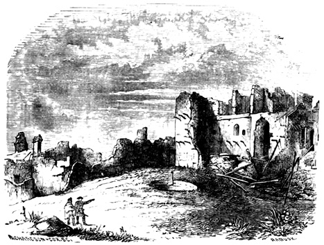
Ruins of Pecos.
Of the ruined Pueblo towns no extended description is necessary, since they present no contrasts with those still inhabited which have been described. Pecos was formerly one of the most important, and was still inhabited in the early part of the present century. The cut copied from Emory for Mr Baldwin's work, represents a portion of the ruins, which include Spanish and aboriginal structures, both of adobe. Emory noticed large well-hewn timbers. Davis says the ruins of the village cover two or three hundred yards, and include large blocks of stone, square and oblong, weighing over a ton, with marks of having been laid in mortar. Hughes speaks of the traces of a stone wall eight feet high, which once surrounded this Pueblo town. Kit Carson told Mr Meline that he found the town still inhabited in 1826. It was here that in former times was kept burning the everlasting fire which formed part of the religious rites in honor of their deity, or, according to the modern account, of Montezuma. There is no evidence, however, that the aborigines in ancient times had any deity, or monarch of that name; it is quite certain that they did not hear of the Aztec monarch Montezuma many centuries before he began to reign; just possible that they did hear of his fame a few years before the Spaniards came to New Mexico; but altogether probable that they first heard the name of Montezuma, of the Aztec people, and of their former migration southward, from the Spaniards themselves, or their native companions.[XI-63]
With the Quivira located by Thomas Gage and other early writers and map-makers, "on the most Western part of America just over against Tartary," as with the great city of Quivira which Francisco Vasquez de Coronado sought and has been popularly supposed to have found, I have at present nothing to do. It should be noted, however, that the latter Quivira was not one of the Pueblo towns of the Rio Grande, but a town of wigwams on the plains in the far north-east. The ruined town of Quivira or Gran Quivira, east of the Rio Grande, entirely distinct from that of Coronado, includes, like Pecos, a Spanish church among its ruins. The buildings are of hewn stone and of great extent. Gregg speaks of an aqueduct leading to the mountains eight or ten miles distant, the nearest water. This town was very likely, like many others, ruined at the revolt of 1680. Abó, Quarra, Laguna, and the rest, present no new features. There are, moreover, on the Puerco River—a tributary of the Rio Grande, and not that of the Colorado Chiquito already mentioned—many traces of Pueblo buildings which have no definite names.[XI-64]
SEVEN CITIES OF CÍBOLA.
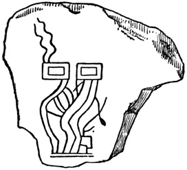
Rock-Inscriptions—Rio Grande.
The cut shows some rock-inscriptions copied by Froebel in the valley of the Rio Grande. In the Sierra de los Mimbres, towards the source of the Gila, are some old copper mines, and connected with them an adobe fort with round towers at the corners, but I do not know that these works have ever been considered of aboriginal origin. In a newspaper I find the remarkable statement that "from the volcanic cones of the Cerrillos was furnished, a great part, if not all, the Chalchiuite, so much worn for ornament, and so highly prized by the ancient Mexicans.... The ancient excavations made in search of it are now distinctly visible, and seem to have been carried to the depth of two hundred feet or more."[XI-65]
The ruins of Old Zuñi have already been described, and there is no reason to doubt that both these and the other remains on the Zuñi River, represent towns that were inhabited when the Spaniards first came northward. Indeed it is almost certain that they, together with the Pueblo town of Zuñi, represent Coronado's famous 'seven cities' of Cíbola. Most writers have so decided, as Gallatin, Squier, Whipple, Turner, Kern, and Simpson.[XI-66] The course and distance of Coronado's march from the Gila agrees more exactly with Zuñi than with any other town; the location of the 'seven cities' within four leagues together, in a very narrow valley between steep banks, as also their position with respect to the Rio del Lino, Colorado Chiquito, correspond very well with the Zuñi ruins; Coronado's Granada, on a high bluff, with a "narrow winding way," was quite probably Old Zuñi; Cíbola is said to have been the first town reached in coming across the desert from the south-west, and the last left in returning; the positions of Tusayan, a province of seven villages, five days' journey north-west from Cíbola, and of Acuco, five days eastward, agree very well with the location of the Moqui towns and of Acoma with respect to Zuñi. Finally we have Espejo's statement that he visited the province of Zuñi, twenty-five leagues west of Acoma; that it was called Zuñi by the natives and Cíbola by the Spaniards; that Coronado had been there; and that he found there not only crosses and other emblems of Christianity, but three Christians even. Coronado left three men at Cíbola, and their statements to Espejo respecting the identity of Cíbola and Zuñi, must be regarded as conclusive.[XI-67]
GENERAL RÉSUMÉ.
New Mexican antiquities, divided as at the beginning of the chapter into six classes, may be briefly considered, en résumé, as follows: 1st. "Remains of ancient stone and adobe buildings in all stages of disintegration, from standing walls with roofs and floors, to shapeless heaps of débris, or simple lines of foundation-stones." This first class of remains has received most attention in the preceding pages, and little need be said in addition. It has been noted that adobe is the material used almost exclusively in the Gila and other southern valleys, as in Chihuahua, while further north stone is preferred. The most important fact to be noted is that all the ruins, without exception, are precisely identical in plan, architecture, and material with the Pueblo towns now inhabited or known to have been inhabited since the coming of the Spaniards. Many of them, particularly those of the Chaco cañon, may have been much grander structures and have displayed a higher degree of art than the modern towns, but they all belong to the same class of buildings.
2d. "Anomalous structures of stone or earth, the purpose of which, either by reason of their advanced state of ruin, or of the comparatively slight attention given them by travelers, is not apparent." Such remains, which have been described as far as possible wherever they have appeared, are: I. Fortifications, like the stone enclosures on the Pueblo Creek and head-waters of the Rio Verde; and the battlements guarding the path of ascent to Old Zuñi. Many of the ruined towns were, moreover, effectually fortified by the natural position in which they were built. II. Mound-like structures and elevations. These include the low terraced pyramid reported on the Gila near the Casa Grande, and another of like nature on the north side of the river; the shapeless heaps of earth and stones in the Gila and Salinas valleys, most of which are doubtless the remains of fallen walls, but some of which may possibly have a different origin and design; and some small heaps of loose stones on the Gila at the mouth of the Santo Domingo. It is noticeable that no burial mounds, of so common occurrence in many parts of America, have been found here; and no pyramids or mounds presumably connected in any way with religious rites, indeed, nothing of the nature of temples or altars, save the estufas still in common use. III. Excavations. These are, a reservoir with stone walls measuring forty by sixty yards, reported by the early writers near the Casa Grande on the Gila; a circular depression forty paces in diameter on the north bank of the Gila, and a similar one at Navajo Spring near the Rio Puerco of the West; a triangular depression at the mouth of the Santo Domingo; quarries of sandstone near some of the Chaco ruins, and pits in the Salinas, whence the earth for building is supposed to have been taken; and the circular holes that penetrate the cañon walls of the Chaco. IV. Enclosures for various or unknown purposes. Such is the circular enclosure a hundred yards in circumference near the Casa Grande, and another north of the river; the structure indefinitely reported as a labyrinth up the Gila from the Casa Grande; a small round enclosure on the Salado; an elliptical enclosure of stone and mortar, eight by sixteen feet, and divided into two compartments, in the Chaco cañon; and the large and irregular lines of foundation-stones in the Gila Valley above the San Pedro. It will be observed that there is very little of the mysterious connected with these remains of the second class, and a great part of that little would probably disappear as a result of a more careful exploration.
3d. "Traces of aboriginal agriculture, in the shape of acequias and zanjas, or irrigating canals and ditches." Such remains have been noticed in connection with many of the ruins, particularly in the south, and require no further remarks. So far as described, they are nothing but simple ditches dug in the surface of the ground, of varying depth and length. The earlier reports of canals with walled sides are very probably unfounded.
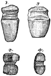
New Mexican Stone Axes.
4th. "Implements and ornaments." These are not numerous, include no articles of any metal whatever, and do not differ materially from articles now in use among the Pueblo Indians. Such relics have been found scattered among the débris of the fallen walls, and not taken from regular excavations; consequently no absolute proof exists that they are the work of the builders, though there can be little room for doubt on that point. The wandering tribes that have occupied the country in modern times are much more likely to have sought for and carried away relics of the original inhabitants, than to have deposited among the ruins articles made by the modern Pueblo Indians. A detailed account of each relic would be useless, but among the articles that have been found are included,—I. Implements of stone. Metates, or corn-grinders, generally broken, were found at various points on the Gila, Salado, and among the ruins near Pecos. Stone axes, are shown in the cut from Whipple, of which No. 4 was found on the Salado, where implements called hoes, and a stone pestle, are also reported. A stone axe was also found on the Colorado Chiquito. Arrow-heads of obsidian were picked up at Old Zuñi, on the Colorado Chiquito, on the Rio Puerco of the west, and at Inscription Rock; of carnelian on the Colorado Chiquito; of agate and jasper on the Rio Puerco; and of quartz near Pecos and on Pueblo Creek. Ross Browne heard of bone awls having been dug up at the Casa Grande. II. Ornaments. Sea-shells were found at the Casa Grande, on the north bank of the Gila, and in the Salado valley; also on the Gila, a bead of blue marble finely turned, an inch and a quarter long; and another bead of the size of a hen's egg; also a painted stone not described, and a beaver's tooth. Several green stones, like amethysts, were found on the Salado; fragments of quartz crystal at the Casa Grande; of agate and obsidian among the Gila mines; and of obsidian on Pueblo Creek. Clay balls from the size of bullets to grape-shot, many of them stuck together, are reported on doubtful authority.[XI-68]
5th. Pottery, the most abundant class of relics, found strewn over the ground in the vicinity of every ruin in this group. It is always in fragments, no whole article of undoubted antiquity having ever been found. This is natural enough, perhaps, since only the surface has been examined, and the roaming tribes of Indians would not be likely to leave anything of use or value; excavation may in the future bring to light whole specimens. But although the absence of whole vessels is not strange, the presence of fragments in so great abundance is very remarkable, since no such tendency to their accumulation is noticed about the inhabited Pueblo towns. It would seem as if the inhabitants, forced to abandon their houses in haste, had deliberately broken all their very large stock of earthen ware, either to prevent its falling into the hands of enemies, or from some superstitious custom. The fragments are very like one to another in all parts of the New Mexican region, and in quality and ornamentation nearly identical with the ware still manufactured and used by the Pueblos. It has been noticed, however, that the older pottery is superior generally in material and workmanship to the modern; and also in the southern valleys it is found painted on the inside as well as outside, contrary as is said to the present usage. Very few fragments show anything like glazing. The painted ornamentation consists in most instances of stripes or angular, more rarely of curved, lines, in black, white, and red. Painted representations of any definite objects, animate or inanimate, are of very rare occurrence. Some specimens are, however, not painted, but decorated with considerable skill by means of raised or indented figures. I have given cuts of many specimens, and the thirty-five figures on the next page from different localities will suffice to explain the nature and uniformity of New Mexican pottery.[XI-69]
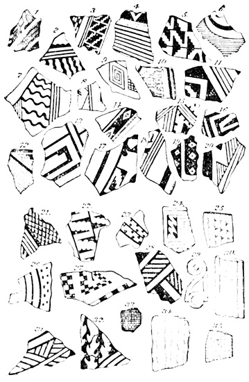
New Mexican Pottery.
6th. "Painted or engraved figures on cliffs, boulders, and the sides of natural caverns." These figures have been mentioned whenever they occurred, and some of them illustrated. There are additional paintings in a rocky pass between Albuquerque and Laguna, mentioned and copied by Möllhausen, and both paintings and sculptures in Texas at Sierra Waco, thirty miles east of El Paso, and at Rocky Dell Creek, in lat. 35°, 30´, long. 102°, 30´.[XI-70] In another volume of this work,[XI-71] something has been said of hieroglyphic development, of the different classes of picture-records, and their respective value. The New Mexican rock-inscriptions and paintings, such of them as are not mere idle sketches executed without purpose by the natives to while away the time, belong to the lower classes of representative and symbolic picture-writing, and are utterly inadequate to preserve any definite record far beyond the generation that executed them. Most of them had a meaning to the artist and his tribe at the time they were made; it is safe to suppose that no living being to-day can interpret their meaning, and that they never will be understood. The similar figures painted on the walls of modern estufas,[XI-72] the natives will not, probably cannot, explain. Mr Froebel, in opposition to Mr Bartlett's theory that the figures are meaningless, very justly says: "Many circumstances tend to disprove that these characters were originally nothing but the results of an early attempt at art. In the first place, the similarity of the style, in localities a thousand miles apart, and its extreme peculiarity, preclude every idea of an accidental similarity. One cannot imagine how the same recurring figures should have been used over and over again, unless they had a conventional character, and were intended to express something."[XI-73]
CONCLUSIONS.
I conclude this division of my work by a few general remarks, embodying such conclusions respecting the New Mexican ruins as may be drawn from the ruins themselves, without reference to the mass of speculation, tradition, and so-called history, that has confused the whole subject since first the missionary padres visited and wrote of this region, and sought diligently, and of course successfully, for traditions respecting the Asiatic origin of the Americans, and the southern migration of the Aztecs from the mysterious regions of the Californias to Anáhuac. These conclusions are not lengthy or numerous, and apply with equal force to the Casas Grandes of Chihuahua, outside of the geographical limits of this chapter.
1. The ruined structures offer but little internal evidence of their age. There is not even the slight aid of forest growth found in nearly all other parts of America. The different buildings show very different degrees of dilapidation it is true, but to what extent in each case the ravages of time have been assisted by the roaming Apaches and other savages, it is impossible to decide. The Casas Grandes of Chihuahua are much more dilapidated than the similar Casa Grande of the Gila; but, although both are built of mud, a slight difference in the quality of the mud employed, with the more abundant rains of Chihuahua, would account for the better condition of the Gila remains, and prevent us from assigning necessarily a greater antiquity to those of Chihuahua. It is known as a historical fact that the southern buildings were not only in ruins at the coming of the Spaniards in the middle of the sixteenth century, but had been so long in that condition that the native knowledge respecting them had passed into the state of a tradition and a superstition. Certainly not less than a century would suffice for this. Of the northern ruins very many are known to have been inhabited and flourishing towns when the Spaniards came. That any were at that time in ruins is not proven, though possible.
2. The material relics of the New Mexican group bear no resemblance whatever to either Nahua or Maya relics in the south. It has been constantly stated and repeated by most writers, that all American aboriginal monuments, the works of the Mound-Builders of the Mississippi, the ruins of New Mexico and Arizona, the Casas Grandes of Chihuahua, the Edificios of Zacatecas, the pyramids of Anáhuac and the central plateaux, Mitla, Palenque, the cities of Yucatan, and finally Copan, all belong evidently to one class and present one type; that all are such as might reasonably be attributed to the same people in different periods of their civilization. It is even customary for travelers and writers to speak without hesitation of Aztec ruins and relics in Arizona, as if there were no longer any doubt on the subject. So far as the New Mexican link in the chain is concerned, I most emphatically deny the resemblance, on grounds which the reader of the preceding pages already fully understands. I can hardly conceive of structures reared by human hands differing more essentially than the two classes in question. In the common use of adobes for building-material; in the plain walls rising to a height of several stories; in the terrace structure, absence of doors in the lower story, and the entrance by ladders; in the absence of arched ceilings of overlapping blocks, of all pyramidal structures, of sculptured blocks, of all architectural decorations, of idols, temples, and every trace of buildings evidently designed for religious rites, of burial mounds and human remains; and in the character of the rock-inscriptions and miscellaneous relics, not to go farther into details, the New Mexican monuments present no analogies to any of the southern remains. I do not mean to express a decided opinion that the Aztecs were not, some hundreds or thousands of centuries ago, or even at a somewhat less remote period, identical with the natives of New Mexico, for I have great faith in the power of time and environment to work unlimited changes in any people; I simply claim that it is a manifest absurdity to suppose that the monuments described were the work of the Aztecs during a migration southward, since the eleventh century, or of any people nearly allied in blood and institutions to the Aztecs as they were found in Anáhuac.
3. Not only do the ruins of this group bear no resemblance to those of the south, but they represent in all respects buildings like those still inhabited by the Pueblo tribes and the Moquis, and do not differ more among themselves than do the dwellings of the peoples mentioned. Every one of them may be most reasonably regarded as the work of the direct ancestors of the present inhabitants of the Pueblo towns, who did not differ to any great extent in civilization or institutions from their descendants, though they may very likely have been vastly superior to them in power and wealth. Consequently there is not a single relic in the whole region that requires the agency of any extinct race of people, or any other nations—using the word in a somewhat wider signification than has sometimes been given to it in the preceding volumes—than those now living in the country. Not only do the remains not point in themselves to any extinct race, but if there were any traditional or other evidence indicating the past agency of such a race, it would be impossible to reconcile the traditional with the monumental evidence except by the supposition that the Pueblos are a foreign people who took possession of the abandoned dwellings of another race, whose institutions they imitated to the best of their ability; but I do not know that such a theory has ever been advanced. I am aware that this conclusion is sadly at variance with the newspaper reports in constant circulation, of marvelous cities, the remnants of an advanced but extinct civilization, discovered by some trapper, miner, or exploring expedition. I am also aware of the probability that many ruins in addition to those I have been able to describe, have been found by military officials, government explorers, and private individuals during the past ten years; and I hope that the appearance of this volume may cause the publication of much additional information on the subject,—but that any of the newly discovered monuments differ in type from those previously known, there is much reason to doubt. Very many of the newspaper accounts referred to relate to discoveries made by Lieut. Wheeler's exploring party during the past two or three years. Lieut. Wheeler informs me that the reports, so far as they refer to the remains of an extinct people, are without foundation, and that his observations have led him to a conclusion practically the same as my own respecting the builders of the ruined Pueblo towns.