Volume 4 — CHAPTER X. ANTIQUITIES OF THE NORTHERN MEXICAN STATES.
Reading edition
The Home of the Chichimecs—Michoacan—Tzintzuntzan, Lake Patzcuaro, Teremendo—Aniche and Jiquilpan—Colima—Armería and Cuyutlan—Jalisco—Tonala, Guadalajara, Chacala, Sayula, Tepatitlan, Zapotlan, Nayarit, Tepic, Santiago Ixcuintla, and Bolaños—Guanajuato—San Gregorio and Santa Catarina—Zacatecas—La Quemada and Teul—Tamaulipas—Encarnacion, Santa Barbara, Carmelote, Topila, Tampico, and Burrita—Nuevo Leon and Texas—Coahuila—Bolson de Mapimi, San Martero—Durango—Zape, San Agustin, and La Breña—Sinaloa and Lower California—Cerro de las Trincheras in Sonora—Casas Grandes in Chihuahua.
A somewhat irregular line extending across the continent from north-east to south-west, terminating at Tampico on the gulf and at the bar of Zacatula on the Pacific, is the limit which the progress northward of our antiquarian exploration has reached, the results having been recorded in the preceding chapters. The region that now remains to be traversed, excepting the single state of Michoacan, the home of the Tarascos, is without the limits that have been assigned to the Civilized Nations, and within the bounds of comparative savagism. The northern states of what is now the Mexican Republic were inhabited at the time of the Conquest by the hundreds of tribes, which, if not all savages, had at least that reputation among their southern brethren. To the proud resident of Anáhuac and the southern plateaux, the northern hordes were Chichimecs, 'dogs,' barbarians. Yet several of these so-called barbarian tribes were probably as far advanced in certain elements of civilization as some of the natives that have been included among the Nahuas. They were tillers of the soil and lived under systematic forms of government, although not apparently much given to the arts of architecture and sculpture. Only one grand pile of stone ruins is known to exist in the whole northern Chichimec region, and the future discovery of others, though possible, is not, I think, very likely to occur. Nor are smaller relics, idols and implements, very numerous, except in a few localities; but this may be attributed perhaps in great degree to the want of thorough exploration. A short chapter will suffice for a description of all the monuments south of United States territory, and in describing them I shall treat of each state separately, proceeding in general terms from south to north. A glance at the map accompanying this volume will show the reader the position of each state, and each group of remains, more clearly than any verbal location could do.
TARASCAN MONUMENTS.
The civilized Tarascos of Michoacan have left but very few traces in the shape of material relics. Their capital and the centre of their civilization was on the shores and islands of Lake Patzcuaro, where the Spaniards at the time of the Conquest found some temples described by them as magnificent.[X-1] Beaumont tells us that the ruins of a 'plaza de armas' belonging traditionally to the Tarascos at Tzintzuntzan, the ancient capital, were still visible in 1776, near the pueblo of Ignatzio, two leagues distant. Five hundred paces west of the pueblo a wall, mostly fallen, encloses a kind of plaza, measuring four hundred and fourteen by nine hundred and thirty feet. The wall was about sixteen feet thick and eighteen in height, with terraces, or steps, on the inside. In the centre were the foundations of what the author supposes to have been a tower, and west of the enclosed area were three heaps of stones, supposed to be burial mounds. Two idols, one in human form, lacking head and feet, the other shaped like an alligator, were found here, carved from a stone called tanamo, much like the tetzontli. The same author says, "respecting the ruins of the palace of the Tarascan kings, according to the examination which I lately made of these curiosities, I may say that eastward of this city of Tzintzuntzan, on the slope of a great hill called Yaguarato, a hundred paces from the settlement, are seen on the surface of the ground some subterranean foundations, which extend from north to south about a hundred and fifty paces, and about fifty from east to west, where there is a tradition that the palace of the ancient kings was situated. In the centre of the foundation-stones are five small mounds, or cuicillos, which are called stone yacatas, and hewn blocks, over which an Indian guardian is never wanting, for even now the natives will not permit these stones to be removed." "On the shores of Lake Siraguen are found ancient monuments of the things which served for the pleasure of the kings and nobles, with other ruined edifices, which occur in various places."[X-2] Tzintzuntzan is on the south-eastern shore of the lake, some leagues northward from the modern Patzcuaro. Lyon in later times was told that the royal palace and other interesting remains were yet to be seen on the lake shores, but he did not visit them.[X-3]
TEREMENDO AND ANICHE.
Another early writer, Villa-Señor y Sanchez, says that in 1712 he, with a companion, entered what seemed a cavern in a deep barranca at Teremendo, eight leagues south-west of Valladolid, or Morelia. "There were discovered prodigious aboriginal vaults, bounded by very strong walls, rendered solid by fire. In the centre of the second was a bench like the foot of an altar, where there were many idols, and fresh offerings of copal, and woolen stuffs, and various figures of men and animals." It was found according to this author that the builders had constructed walls of loose stones of a kind easily melted, and then by fire had joined the blocks into a solid mass without the use of mortar, continuing the process to the roof. The outside of the structure was overgrown with shrubs and trees.[X-4]
At Aniche, an island in Lake Patzcuaro, Mr Beaufoy discovered some hieroglyphic figures cut on a rock; and at Irimbo about fifty miles east of Morelia, he was shown some small mounds which the natives called fortifications, although there was nothing to indicate that such had been their use.[X-5] In the mountains south-east of Lake Chapala, in the region of Jiquilpan, Sr García reports the remains of an ancient town, and says further that opals and other precious stones well worked have been obtained here.[X-6] Humboldt pictures a very beautiful obsidian bracelet or ring, worked very thin and brilliantly polished; and another writer mentions some giants' bones, all found within the limits of Michoacan.[X-7]
At the time when official explorations were undertaken by Dupaix and Castañeda in the southern parts of New Spain, it seems that officials in some northern regions also were requested by the Spanish government to report upon such remains of antiquity as might be known to exist. The antiquarian genius to whom the matter was referred in Colima, then a department of Michoacan, but now an independent state, made a comprehensive report to the effect that he "had not been able to hear of anything except an infinite number of edifices of ruined towns," and some bones and other remains apparently of little importance, which had been taken from excavations on the hacienda of Armería and Cuyutlan, and which seemed to have been destroyed and covered up by volcanic eruptions. If this archæologist had found more than 'an infinite number' of ruins, it might possibly have occurred to him to describe some of them.[X-8] Nothing more is known of Colima antiquities.
PYRAMID OF TEPATITLAN.
At Tonala, probably just across the Colima line northward in the state of Jalisco, the report sent in reply to the inquiry just spoken of, mentioned a hill which seemed to be for the most part artificial, and in which excavations revealed walls, galleries, and rooms. Similar works were said to be of frequent occurrence in that region. In digging for the foundations of the Royal Hospital at Guadalajara, "there was found a cavity, or subterranean vault, well painted, and several statues, especially one which represents an Indian woman in the act of grinding corn." It was hollow, and probably of clay. Near Autlan, in the south-west, there were said to exist some traces of feet sculptured in the rock, one at the ford called Zopilote, and another on the road between Autlan and Tepanola. Near Chacala, still further south, "there is a tank, and near it a cross well carved, and on its foot certain ancient unknown letters, with points in five lines. On it was seen a most devoted crucifix. Under it are other lines of characters with the said points, which seemed Hebrew or Syriac." This information comes from an old author, and is a specimen of the absurd reports of the Christian gospel having been preached at various points in these regions, which are still believed to a considerable extent by a certain class of the people of Mexico.[X-9]
An author who wrote in 1778 states that between Guadalajara and Sayula, and four leagues north-east of the latter town, "there is a causeway of stone and earth, about half a league long, across the narrowest part of a marsh, or lagoon. There is a tradition that the gentiles built it in ancient times. On most parts of its shores this marsh has little heaps of pottery in fragments, very wide and thick, and there can still be found figures of large vessels, and also foundations and traces of small houses of stone. Tradition relates that the antiguos of different nations came here to make salt, and that they had several bloody fights, of which many traces appear in the shape of black transparent flints worked into arrow-points."[X-10]
Mr Löwenstern discovered near Tepatitlan, some fifty miles north-east of Guadalajara, a pyramid described as somewhat similar to those of Teotihuacan, but smaller, its exact dimensions not being given, but the height being estimated at from ninety to a hundred and thirty feet. It was built in three stories of earth, sand, and pebbles, and bore on its summit a dome-shaped mound. The pyramid at the base was encased with large stones; whether or not they were in hewn blocks is not stated, but the stones lying about indicated that the whole surface had originally borne a stone facing. The form of the base was quadrangular, but time and the cultivation of the whole surface as a cornfield, had modified the original form and given the structure an octagonal conformation with not very clearly defined angles. It requires additional evidence to prove that this supposed pyramid was not a natural hill like Xochicalco with some artificial improvement. The hill is called Cerrito de Montezuma, the custom of applying this monarch's name to every relic of antiquity being even more common in the northern regions than in other parts of the country. The author of Cincinnatus' Travels, mentions a 'mound' at Zapotlan, about fifty miles east of Guadalajara, which is five hundred feet high. He does not expressly state that it is artificial, and a gentleman familiar with the locality tells me that it is not generally so regarded, having the appearance of a natural grass-covered hill.[X-11]
In the northern part of the state, in the region of Tepic, the Spaniards seem to have found grander temples, a more elaborate religious system, and a civilization generally somewhat more advanced than in most other parts of the north or north-west. Still no well-defined architectural monuments are reported on good authority in modern times. It is to the earlier writers that we must go for accounts of any extensive remains, and such accounts in all cases probably refer to the buildings which the Spaniards found still in use among the natives; and the old writers were ready to seize upon every scrap of rumor in this direction, that they might successfully trace the favorite southward course of the Aztecs to Anáhuac. Hervas says that "there have been found and still exist in Nayarit ruins of edifices which by their form seem to be Mexican, and the natives say that the Mexicans built them when they were in Nayarit."[X-12] This was another of the regions where some wandering apostle preached the gospel in aboriginal times, and the 'cross of Tepic' was one of the celebrated Christian relics. Some wonderful foot-prints in the stone are also among the reported relics.[X-13] A temple of hewn stone, situated on a rocky hill, ascended by a winding road, was found at Xuchipiltepetl by the Spanish explorers in 1841; and Villa-Señor describes a cave where the natives were wont to worship the skeleton of an ancient king gaily appareled and seated in state upon a throne.[X-14] Finally Prichard informs us that "near Nayarit are seen earthen mounds and trenches."[X-15]
SANTIAGO IXCUINTLA.
A writer in the Boletin of the Mexican Geographical Society describes the temple at Jalisco as it was found by the first Spaniards; and another in the Nouvelles Annales des Voyages states that the village of Jalisco, about a league from Tepic, is built on the ruins of the ancient city, and that "in making excavations there are found utensils of every kind, weapons and idols of the Mexican divinities."[X-16] After all, the only definite account extant of relics found in this part of the state is that by Sr Retes. He says that the northern bank of the Rio Grande, or Tololotlan, contains numerous remains for three or four hundred miles, consisting chiefly of stone and clay images and pottery, and occurring for the most part on the elevated spots out of the reach of inundations. The part of this region that has been most explored, is the vicinity of Santiago Ixcuintla, twenty-five or thirty miles from the mouth of the river. On the slope of a hill four leagues north-west of Santiago, at the foot of Lake San Juan, was found a crocodile of natural size carved from stone, together with several dogs or sphinxes, and some idols, which the author deems similar to those of the Egyptians. Human remains have been found in connection with the other relics, and most of the latter are said to have been sent to enrich European collections by rich foreign residents of Tepic. The objects consist of idols in human and animal forms, axes, and lances, the pottery being in many cases brightly colored. The cut shows six of the thirty-eight relics pictured in the plates given by Retes. Fig. 1, 2, are the heads of small stone idols, the first head being only two inches in height. Fig. 3 is a head of what the author calls a sphinx. Fig. 4 is an earthen-ware mold for stamping designs on cloth or pottery; there are several of these represented in the collection. Fig. 5 is an earthen jar six inches high, of a material nearly as hard as stone. Many of the jars found are very similar to those now made and used in the same region. Fig. 6 is an earthen idol four inches high. Among the other objects is a flint lance-head with notches like saw-teeth on the sides.[X-17] Similar relics, but of somewhat ruder style and coarser material, have been found at a locality called Abrevadero, about eighteen miles south of Santiago towards Tepic.[X-18] At Bolaños, some distance east from Santiago, on a northern branch of the same river, Lyon obtained, by offering rewards to the natives, "three very good stone wedges or axes of basalt." Bones of giants were reported at a distance of a day's journey. At the same distance southward "there is said to be a cave containing several figures or idols in stone."[X-19]
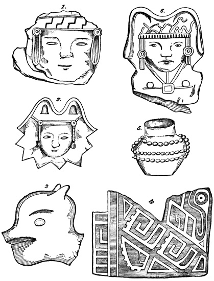
Relics from Santiago, Jalisco.
ANTIQUITIES OF GUANAJUATO.
Respecting the antiquities of Guanajuato Sr Bustamante states that the only ones in the state are some natural caves artificially improved, as in the Cerro de San Gregorio, on the hacienda of Tupátaro; and some earthen mounds in the plains of Bajio, proved to be burial mounds. Under the earth and a layer of ashes the skeleton lies with its head covered by a little brazier of baked clay, and accompanied by arrows, fragments of double-edged knives, obsidian fragments, bird-bone necklaces strung on twisted bird-gut, smooth stones, some small semi-spheres of baked clay with a hole in the centre of each, and a few grotesque idols.[X-20]
Castillo describes a small human head, brought from the mines of Guanajuato, the material of which was a "concretion of quartz and chalcedony for the most part, sprinkled with fine grains of gold, and a little pyrites, of a whitish color, but partly stained red by the oxide of iron." This head, it seems, was claimed by some to be a petrifaction, but the author is of a contrary opinion, although he believes there is nothing artificial about it except the mouth.[X-21] Finally Berlandier describes two pyramids near the pueblo of Santa Catarina, in the vicinity of the city of Guanajuato. They are square at the base, face the cardinal points, and are built of pieces of porphyry laid in clayey earth. The eastern pyramid is twenty-three feet high, thirty-seven feet square at the base, with a summit platform fifteen feet square. The corresponding dimensions of the western mound are eighteen, thirty-seven, and fifteen feet. They are only fifteen or twenty feet apart, and are joined by an embankment about five feet high.[X-22]
RUINS OF QUEMADA.
The most important and famous ruins of the whole northern region are those known to the world under the name of Quemada, in southern Zacatecas. The ruins are barely mentioned by the early writers as one of the probable stations of the migrating Aztecs; and the modern explorations which have resulted in published descriptions were made between 1826 and 1831, although Manuel Gutierrez, parish priest of the locality in 1805, wrote a slight account which has been recently published.[X-23] Capt. G. F. Lyon visited Quemada in 1826, and published a full description, illustrated with three small cuts, in his journal.[X-24] Gov. García of Zacatecas ordered Sr Esparza in 1830 to explore the ruins. The latter, however, by reason of other duties and a fear of snakes, was not able to make a personal visit, but obtained a report from Pedro Rivera who had made such a visit. The report was published in the same year.[X-25]
Mr Berghes, a German mining engineer, connected with the famous Veta Grande silver mines, made a survey of the ruins in 1831, for Gov. García, and from the survey prepared a detailed and presumably accurate plan of the works, which was afterwards published by Nebel, and which I shall copy in this chapter. Mr Burkart, another engineer, was the companion of Berghes, and also visited Quemada on several other occasions. His published account is accompanied by a plan agreeing very well with that of Berghes, but containing fewer details.[X-26] Nebel visited Quemada about the same time.[X-27] His plates are two in number, a general view of the ruins from the south-west, and an interior view of one of the structures, besides Berghes' plan. His views, so far as I know, are the only ones ever published.[X-28]
The location is about thirty miles southward of the capital city of Zacatecas, and six miles northward of Villanueva. The stream on which the ruins stand is spoken of by Burkart as Rio de Villanueva, and by Lyon as the Rio del Partido. The name Quemada, 'burnt,' is that of a neighboring hacienda, about a league distant towards the south-west. I do not know the origin of the name as applied to the hacienda, but there is no evidence that it has any connection with the ruins. The local name of the latter is Los Edificios. The only other name which I have found applied to the place is Tuitlan. Fr Tello, in an unpublished history of Nueva Galicia written about 1650, tells us that the Spaniards under Capt. Chirinos "found a great city in ruins and abandoned; but it was known to have had most sumptuous edifices, with grand streets and plazas well arranged, and within a distance of a quarter of a league four towers, with causeways of stone leading from one to another; and this city was the great Tuitlan, where the Mexican Indians remained many years when they were journeying from the north."[X-29] This ruined city was in the region of the modern town of Jerez, and without much doubt was identical with Quemada. Sr Gil applies the same name to the ruins. Others without any known authority attempt to identify Quemada with Chicomoztoc, 'the seven caves' whence the Aztecs set out on their migrations; or with Amaquemecan, the ancient Chichimec capital of the traditions. Gil rather extravagantly says, "these ruins are the grandest which exist among us after those of Palenque; and on examining them, it is seen that they were the fruit of a civilization more advanced than that which was found in Peru at the time of the Incas, or in Mexico at the time of Montezuma."[X-30]
LOS EDIFICIOS OF QUEMADA.
The Cerro de los Edificios is a long narrow isolated hill, the summit of which forms an irregular broken plateau over half a mile in length from north to south, and from one hundred to two hundred yards wide, except at the northern end, where it widens to about five hundred yards. The height of the hill is given by Lyon as from two to three hundred feet, but by Burkart at eight to nine hundred feet above the level of the plain. In the central part is a cliff rising about thirty feet above the rest of the plateau. From the brow the hill descends more or less precipitously on different sides for about a hundred and fifty feet, and then stretches in a gentler slope of from two to four hundred yards to the surrounding plain. On the slope and skirting the whole circumference of the hill, except on the north and north-east, are traces of ancient roads crossing each other at different angles, and connected by cross roads running up the slope with the works on the summit. Berghes' plan of Quemada is given on the following page, on which the roads spoken of are indicated by the dotted lines marked H, H, H, etc. This plan and Burkart's plan and description are the only authorities for the existence of the roads running round the hill, Lyon and other visitors speaking only of those that diverge from it; but it is probable that Berghes' survey was more careful and thorough than that of the others, and his plan should be accepted as good authority, especially as the other accounts agree with it so far as they go.[X-31]
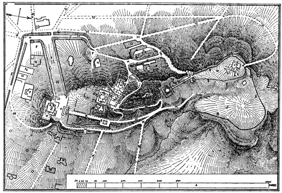
Plan of the Ruins at Quemada.
View larger image.
One of the roads, which turns at a right angle round the south-western slope, has traces of having been enclosed or raised by walls whose foundations yet remain; and from it at a point near the angle a raised causeway ninety-three feet wide extends straight up the slope north-eastward to the foot of the bluff. The walls supposed to have raised those south-western roads are not spoken of by Burkart or shown on his plan; Lyon speaks of certain walls here which he considers those of an enclosed area of some six acres. From a point near the junction of the road and causeway three raised roads, paved with rough stones extend, according to Lyon, in perfectly straight lines S.W., S.S.W., and S.W. by S. The first terminates in an artificial mound across the river towards the hacienda of Quemada;[X-32] the second extends four miles to the Coyote Rancho; and the third is said by the natives to terminate at a mountain six miles distant. Two similar roads thirteen or fourteen feet wide extend from the eastern slope of the hill, one of them crossing a stream and terminating at a distance of two miles in a cuicillo, or heap of stones. Burkart found some evidence that the heap constituted the ruins of a regular structure or pyramid; and Rivera locates the cuicillo on the summit of the Sierra de Palomas. He also speaks of a road running west from the north-western part of the hill to the small hills of San Juan, on the Zacatecas road. Of the other roads radiating from the hill I have no farther information than the fact that they are laid down in the plan.[X-33]
At all points in the whole circumference where the natural condition of the slope is not in itself a sufficient barrier to those seeking access to the summit plateau, the brow of the hill is guarded by walls of stone, marked B on the plan for the northern portions, and indicated generally by the black lines in the south. Indeed the northern end of the mesa, where the approach is somewhat less precipitous than elsewhere, is continuously guarded by such a wall, from nine to twelve feet thick and high, enclosing an irregular triangular area with sides of about four hundred and fifty yards: this area being divided by another wall into two unequal portions.
The most numerous and extensive ruins are on the southern portion of the hill, where a larger part of the uneven surface is formed into platforms or terraces by means of walls of solid masonry. One of these supporting walls is double—that is, composed of two walls placed in contact side by side, one having been completed and plastered before the other was begun, the whole structure being twenty-one feet high and of the same thickness.[X-34] On the platforms thus formed are a great number of edifices in different degrees of dilapidation. Any attempt on my part to describe these edifices in detail from the information afforded by the authorities available could not be otherwise than confusing and unsatisfactory. There is probably no ruin in our territory, the verbal description of which would present so great difficulties, even if the accounts of the original explorers were perfectly comprehensive, as they are not; for perhaps more than three fourths of the structures shown on the plan are not definitely spoken of by any author. I will, however, give as clear a description as possible, referring the reader to the plan and to one view which I shall copy, the only satisfactory one ever published.
Near each end of the wide causeway already mentioned are two comparatively small masses of ruins. One of them appears to have been a square stone building thirty-one feet square at the base and of the same height; the others, now completely in ruins, may perhaps have been of similar dimensions, so far as may be judged by the débris. In the centre of the causeway, perhaps at F of the plan, although described as nearer the bluff, is a heap of stone over a star-shaped border or pavement. On the lower part of the mesa, at the extreme southern end and also near the head of the causeway, at A iv of the plan, is a quadrangular space measuring two hundred by two hundred and forty feet,[X-35] and bounded, at least on the north and east, by a stone terrace or embankment four or five feet high and twenty feet wide, the width of which is probably to be included in the dimensions given.[X-36] Mr Burkart states that near the inner edge of this terrace is a canal a foot deep and wide, covered with stone flags. On the outer edge of the terrace, on the eastern side, stands a wall eight feet thick and eighteen feet high. Mr Lyon thinks the other sides were always open, but Burkart speaks of the wall as having originally enclosed the square, and having been torn down on three sides, which seems much more probable. At one point on the eastern terrace stands a round pillar nineteen feet in circumference and of the same height as the wall, or eighteen feet. There are visible traces of nine other similar pillars, seemingly indicating the former presence of a massive column-supported portico.
Adjoining this enclosure on the east, with only a narrow passage intervening, is another, R of the plan, measuring according to Burkart's measurement, which agrees very nearly with that of Berghes, one hundred by one hundred and thirty-eight feet,[X-37] with walls still perfect, eighteen feet high and eight feet thick, in connection with which no terraces are mentioned, although Rivera speaks of steps on the west. Within the walls, twenty-three feet from the sides and nineteen and a half from the ends, is a line of eleven pillars—Lyon says fourteen, and Rivera ten—each seventeen feet in circumference and of the same height as the walls. There can be little doubt that these columns once sustained a roof. Mr Berghes in one of his excavations in 1831 is said, by Nebel, to have found an ancient roof supported by a column, and showing exactly the method followed by the builders. The roof was made of large flat stones, covered with mortar and supported by beams. It is not quite clear how an excavation on the hill could show such a room, but there is little room to doubt that the roof-structure was similar to that described. Near this second enclosure—and west of it, as is said, but that would be hardly possible—Rivera speaks of a circular ruin sixteen and a half feet in diameter, with five steps leading up to the summit, on which some apartments were still traceable.
From the level platform in front of the two main structures described, a causeway, beginning with a stairway and guarded at the sides by walls for much of its length, leads northward up the slope. About three hundred yards in this direction, possibly at the point marked F on this causeway, is a pyramid in perfect preservation, about fifty feet square at the base, also fifty feet high, with a flat summit. Near this is another pyramid, only twelve feet square and eighteen feet high, but standing on a terrace fifty by one hundred feet. Two bowl-shaped circular pits, eight feet in diameter, with fragments of pottery and traces of fire; a square building ten by eight feet on the inside, with walls ten feet high; and a simple mound of stones eight feet high, are the miscellaneous remains noted in this part of the hill.
The most extensive and complicated ruins are found between the steep central height and the western brow of the hill, where there is a perpendicular descent of a hundred and fifty feet. On this central height itself there are no ruins, but passing nearly round its base are terraced roads twenty-five feet wide, with perpendicular walls only partially artificial. Of the extensive group of monuments on the platform of the south-western base of the central height, only the portion about A ii, of the plan, has been definitely described, and the description, although clear enough in itself, does not altogether agree with the plan. Here we have a square enclosure similar to the one already described in the south at A iv. Its sides are one hundred and fifty feet, bounded by a terrace three feet high and twelve feet wide, with steps in the centre of each side. Back of the terrace on the east, west, and south sides stand walls eight or nine feet in thickness and twenty feet high. The north side of the square is bounded by the steep side of the central cliff, in which steps or seats are cut in some parts in the solid rock, and in others built up with rough stones. In the centre of this side, and partially on the terrace, is a truncated pyramid, with a base of thirty-eight by thirty-five feet, and nineteen feet high, divided into several stories—five according to Nebel's drawing, seven according to Lyon's statement.[X-38]
In front of the pyramid, and nearly in the centre of the square, stands a kind of altar or small pyramid seven feet square and five feet high. A very clear idea of this square is given in the following cut from Nebel's drawing. It presents an interior view from a point on the southern terrace. The pyramid in five stories, the central altar, the eastern terrace with its steps, and standing portions of the walls are all clearly portrayed. The view, however, disagrees very essentially with the plan in representing extensive remains northward from the enclosure on the upper slope, where, according to Berghes' plan, no ruins exist. There is an entrance in the centre of the eastern wall, another in the western, and two on the south. These entrances do not seem to be in the form of doorways, but extend, according to the drawing, to the full height of the walls. That on the east is thirty feet wide and leads to an adjoining square with sides of two hundred feet and walls still perfect. The arrangement of these two adjoining squares is much like that of those at A iv in the south, but in the northern structures there are no pillars to be seen.
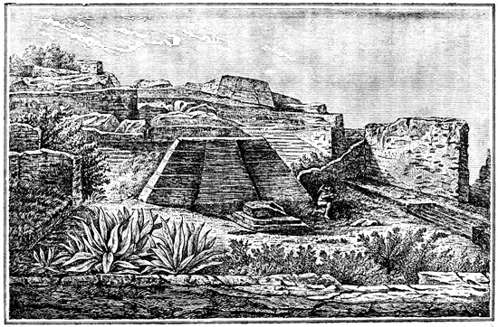
Interior of Los Edificios.
The opening through the western wall leads to the entrance to a cave, reported to be of great extent, but not explored by any visitor on account of the ruined condition of the passage leading to it—or, as Gutierrez says, because the wind issues constantly from the entrance with such force that no one can enter with lights. The mouth of the subterranean passage is on the brink of the western precipice; the walls were plastered, and the top supported by cedar beams. Strangely enough the structure at A iii, so clearly defined on the plan, is not described at all. It seems to be very similar to the enclosures described.
The ruins on the northern part of the plateau are similar in character to those in the south, but fewer in number. Among them are square terraced enclosures like those already mentioned; a pyramid with sloping sides, and eighteen feet square at the summit; a square building sixteen feet square at the base and sixteen feet high; and two parallel stone mounds thirty feet long.
On the lower southern slopes the foundation-stones of numerous buildings are found, and many parts of the adjoining plain are strewn with stones similar to those employed in the construction of the edifices above. There is now no water on the hill, but there are several tolerably perfect tanks, with a well, and what seem to be the remains of aqueducts.
The material of which all the works described are built is the gray porphyry of this and the neighboring hills, and Burkart states that the building-stone of Los Edificios was not quarried in the hill on which they stand, but brought from another across the valley. The nature of the stone permits it to be very easily fractured into slabs, and those employed in the buildings are of different sizes, but rarely exceeding two or three inches in thickness and not hewn. They are laid in a mortar of reddish clay mixed with straw, in which one visitor found a corn-husk. The mortar, according to Burkart, is of an inferior quality,—although others represent it as very good—and on the outer walls and in all exposed situations is almost entirely washed out. Except this washing-out of the mortar, time and the elements have committed but slight ravages at Quemada, the dilapidation of the buildings being due for the most part to man's agency, since most of the buildings of the neighboring hacienda have been constructed of blocks taken from Los Edificios. Lyon found some evidence that the walls were originally plastered and whitened.
A large circular stone from ten to thirteen feet in diameter and from one to three in thickness, according to different observers, on the surface of which were sculptured representations of a hand and foot, was found at the western base of the hill, or as Burkart says, at the eastern base. The editor of the Museo Mexicano also speaks of a sculptured turtle bearing the figure of a reed, the Aztec acatl. No other miscellaneous relics whatever have been found. Nothing resembling inscriptions, hieroglyphics, or even architectural decorations, is found in any part of the ruins. Obsidian fragments, arrow and spear heads, knives, ornaments, heads and idols of terra cotta and stone, pottery whole or in fragments, human remains and burial deposits, some or all of which are strewn in so great abundance in the vicinity of most other American ruins, are here utterly wanting; or at least the only exceptions are a few bits of porphyry somewhat resembling arrow-heads, and some small bits of pottery found by Lyon in the circular pit on the summit.
The works which have been described naturally imply the existence in this spot at some time in the past of a great city of the plain, of which the Cerro de los Edificios was at once the fortified citadel and temple. The paved causeways may be regarded as the principal streets of the ancient city, on which the habitations of the people were built of perishable material, or as constructed for some purely religious purpose not now understood. Mr Burkart suggests that the land in the vicinity was once swampy, and the causeways were raised to ensure a dry road. An examination of their foundation should settle that point, as a simple pavement of flat stones on the surface of a marsh would not remain permanently in place. As simple roads, such structures were hardly needed by barefooted or sandaled natives, having no carriages or beasts of burden; and it seems most reasonable to believe that they had a connection with religious rites and processions, serving at the same time as main streets of a city.
The ruins of Quemada show but few analogies to any of the southern remains, and none whatever to any that we shall find further north. As a strongly fortified hill, bearing also temples, Quemada bears considerable resemblance to Quiotepec in Oajaca; and possibly the likeness would be still stronger if a plan of the Quiotepec fortifications were extant. The massive character, number, and extent of the monuments show the builders to have been a powerful and in some respects an advanced people, hardly less so, it would seem at first thought, than the peoples of Central America; but the absence of narrow buildings covered by arches of overlapping stones, and of all decorative sculpture and painting, make the contrast very striking. The pyramids, so far as they are described, do not differ very materially from some in other parts of the country, but the location of the pyramids shown in the drawing and plan within the enclosed and terraced squares seems unique. The pillars recall the roof structures of Mitla, but it is quite possible that the pillars at Quemada supported balconies instead of roofs; indeed, it seems improbable that these large squares were ever entirely covered. The walls of Los Edificios are higher as a rule than those of other American ruins, and the absence of windows and regular doorways is noticeable. The total want of idols in structures so evidently built, at least partially, for religious purposes, is also a remarkable feature, as is the absence of the usual pottery, implements, and weapons. The peculiar structure, several times repeated, of two adjoining quadrangular spaces enclosed, or partially so, by high walls, and one of them formed by a low terrace into a kind of square basin, containing something like an altar in its centre, is a feature not elsewhere noted. There can hardly be any doubt that these and other portions of the Edificios were devoted to religious rites.
While Quemada does not compare as a specimen of advanced art with Uxmal and Palenque, and is inferior so far as sculpture and decoration are concerned to most other Nahua architectural monuments, it is yet one of the most remarkable of American ruins, presenting strong contrasts to all the rest, and is well worthy of a more careful examination than it has ever yet received. Such an examination is rendered comparatively easy by the accessibility of the locality, and would, I have no doubt, be far from unprofitable in an antiquarian point of view. Los Edificios, like Copan and Palenque, have, so far as has yet been ascertained, no place in the traditional annals of the country, yet they bear no marks of very great antiquity; that is, there is more reason to class them with Xochicalco, Quiotepec, Monte Alban, and the fortified towns of Vera Cruz, than with the cities of Yucatan and Chiapas, or even the pyramids of Teotihuacan and Cholula.
At San Juan Teul, nearly a hundred miles southward from Quemada, the Spaniards found a grand aboriginal temple when they first came to this part of the country; and Frejes, an early writer, says, "there are ruins of a temple and of dwellings not far from the present pueblo." There is, however, no later information respecting this group of remains. At a place called Tabasco, about fifty miles from Quemada, Esparza mentions the discovery of some stone axes. No other antiquities have been definitely reported in the state of Zacatecas, although Arlegui tells us that the early missionaries were much troubled, and hindered in their work of conversion by the constant discovery of idols and temples concealed in the mountains.[X-39]
AGUASCALIENTES AND SAN LUIS POTOSÍ.
I have no record of any relics of antiquity in the state of Aguascalientes: San Luis Potosí has hardly proved a more fruitful field of archæological research. Mayer gives a cut representing a stone axe from this state; Cabrera reports some ancient tombs, or cuicillos,—which he calls cuiztillos; the word being written differently by different authors, and as applied to different states—in the suburbs of the city of San Luis Potosí; and according to a newspaper report two idols and a sacrificial basin, cut from a concrete sandstone, were found in the sierra near the city and brought to New Orleans. One of the idols was of life size, had two faces and a hole for the insertion of a torch in its right hand; the basin was two feet in diameter, and held by intertwined serpents.[X-40]
In southern Tamaulipas relics are quite abundant and of a nature very much the same as that of those which have already been described south of the Rio Pánuco, the boundary line between Tamaulipas and Vera Cruz. At Encarnacion, in the vicinity of Tampico, Mr Furber reports the stone idol shown in front and profile view in the cut. The sculpture is described as rude, and with the idol, three feet high, were dug up several implements and utensils.[X-41] Near a small salt lake between Tula and Santa Barbara, Mr Lyon found a ruined pyramidal mound of hard earth or clay, faced with flat unhewn stones, with similar stones projecting and forming steps leading up the slope on one side. This pyramid is thirty paces in circumference at the base, and is divided by a terrace into two stories, the lower of which is twenty feet high, and the upper in its present state ten feet. Some stone and terra-cotta images have been taken from this mound, and another much smaller but similar structure is reported to exist somewhere in the same vicinity.[X-42]
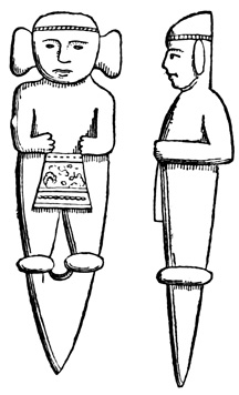
Idol from Tamaulipas.
On the Tamissee River, which flows into Tampico Bay, traces of ancient towns have been found in two localities near the Carmelote Creek. They consist of scattered hewn blocks of stone, covered with vegetable mold and overgrown with immense trees and rank vegetation. At one of these localities the remains include seventeen large earthen mounds, with traces of a layer of mortar at the bottom. In them have been found broken pottery, rudely carved images of natural size in sandstone, and idols and heads in terra cotta. Mr Norman gives cuts representing two of these heads.[X-43]
TOPILA REMAINS.
In the south-western part of the state, in the Topila hills, near a creek of the same name, is a large group of remains at a locality known as Rancho de las Piedras. Mr Norman, who spent a week in their examination, is the only authority for these remains, and as he was obliged to work alone and unaided, his examination was necessarily superficial. Over an area several miles square the ground is strewn with hewn blocks of stone and fragments of pottery and obsidian. Many of the blocks bear decorative sculptured figures. A female face carved from a block of fine dark reddish sandstone, was brought away by Mr Norman and presented to the New York Historical Society. It is shown in the cut. The face is of life size, very symmetrical in its form, and of a Grecian type. Another monument sketched by the explorer was a stone turtle, six feet long, with a human head. The sculpture, especially of the turtle's shell, is described as very fine; the whole rests on a large block of concrete sandstone, and is called by the finder the American Sphinx. This relic was somewhat damaged, but the features of the human face seemed of a Caucasian rather than a native type.
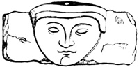
Stone Face—Topila Ruins.
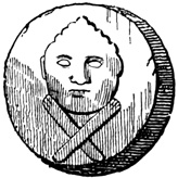
Colossal Head—Topila Ruins.
The Topila ruins include twenty mounds, both circular and square, from six to twenty-five feet in height, built of earth and faced with uniform blocks of sandstone, eighteen inches square and six inches thick. The facings had for the most part fallen, and that invariably inward in the smaller mounds, indicating perhaps their original use as tombs. Many of the blocks are scattered through the forest in places where the mounds had entirely disappeared. Of all the mounds only one has any trace of a terrace, and in that one it is very faint; and there is no evidence that mortar was employed in laying the stones. The largest covered about two acres, and bore on its summit a wild fig-tree one hundred feet high. At its base is a circular wall of stone, the top of which is even with the surface of the ground—perhaps a well—and which is filled with stones and broken pottery. Its top is covered with a circular stone four feet and nine inches in diameter and seven inches thick, with a hole in its centre and some ornamental lines sculptured on its upper surface. Another round stone, twelve feet in diameter and three feet thick, on the front of which is carved a colossal human head, is shown in the cut. The author speaks vaguely of "vast piles of broken and crumbling stones, the ruins of dilapidated buildings, which were strewed over a vast space;" and his cuts of the relics which I have copied show in the background, not included in my copies, regular walls of hewn stone. Mr Norman regards this group as the remains of a great city, the site of which is now covered by a heavy forest. In another locality, seven miles further north-west on the Topila Creek, and a few miles from the Pánuco River, is another group of circular mounds, one of them twenty-five feet high, and the lower portions faced with flat hewn stones. Hewn blocks of various forms and sizes are also scattered about the locality, but none of them are sculptured.[X-44] Lyon tells us that "remains of utensils, statues, weapons, and even skeletons," have been often found in digging for the foundations of new buildings in the vicinity of Tampico, or Tamaulipas. He made drawings, which he did not publish, of two very perfect basalt idols, and mentioned also some bone carvings and terra-cotta idols found in this region.[X-45] In northern Tamaulipas I find only one mention of aboriginal monuments, and that at Burrita, about twenty miles east from Matamoras, respecting which locality Berlandier says, "on a small hill which is seen two or three hundred paces from the rancho of Burrita are found in abundance (as the rancheros say) the bones of ancient peoples."[X-46]
BOLSON DE MAPIMI.
BURIAL CAVES.
Nuevo Leon, adjoining Tamaulipas on the west, is another of the states within whose limits no antiquities have been reported; and in Texas on the north almost the same absence of aboriginal remains is to be remarked, although one group of rock-inscriptions will be noted in a future chapter at Rocky Dell creek, in the north-western part of the state bordering on New Mexico. In the region bordering on the valley known as the Bolson de Mapimi, comprising parts of the states of Coahuila, Durango, and Chihuahua, the natives at some time in the past seem to have deposited their dead in natural caves, and several of these burial deposits of great extent have been discovered and reported. None of them are accurately located by any traveler or writer, nor is it possible to tell in which of the three states any one of them should be described. As antiquities, however, these burial caves do not require a long notice. The one of which most has been written is that discovered by Juan Flores in 1838. The entrance to the cave was at the foot of a hill, and within were seated round the walls over a thousand mummies "dressed in fine blankets, made of the fibres of lechuguilla, with sandals, made of a species of liana, on their feet, and ornamented with colored scarfs, with beads of seeds of fruits, polished bones, &c.," as Wizlizenus says. Mühlenpfordt tells us that Flores to find this cave traveled eastward from the Rancho San Juan de Casta, which is eighty-six leagues northward from Durango. Another traveler heard of several of these caves, and that the remains found were of gigantic size. Mayer gives a report that in latitude 27° 28´ there are a multitude of caverns excavated from solid rock, bearing inscribed figures of animals and men, the latter dressed like the ancient Mexicans. Some of them were described by Fr Rotéa as fifteen by thirty feet, and identical probably with Chicomoztoc, the famous 'seven caves.' A writer in Silliman's Journal, referring perhaps to the same cave, extends the number of mummies from a thousand to millions, and speaks of necklaces of marine shells. Mr Wilson locates one of these mummy-deposits on the western slope of a high mountain overlooking the ancient pueblo of Chiricahui, in Chihuahua probably. Several rows of bodies, dried and shrunken but not decayed, were exposed by an excavation for saltpetre. Each body sewn up in a strong well-woven cloth, and covered again with sewn palm-leaves, lay on its back on two sticks, with knees drawn up to chin, and feet toward the mouth of the cavern. The cave was a hundred feet in circumference and thirty or forty feet high, and the bottom for a depth of twenty feet, at least, was composed of alternate layers of bodies, and of earth and pebbles. The preservation is thought to be attributable to the dryness of the air and the presence of saltpetre. Parts of the mummies, of the wrapping-cloths, bone beads and beads of blue stone, with parts of a belt and tassels, were presented to the California Academy of Natural Sciences in July, 1864. Sr Avila describes two of these caves situated in the vicinity of San Lorenzo, about thirty-five leagues west of Parras, in Coahuila. One had to be entered from the top by means of ropes, and the other had some of its rocks artificially cut and painted. In both of these deposits bones were found instead of mummies, but they were as in the other cases wrapped in cloth and gaily decked with beads, sticks, and tassels. Hair was found on some of the heads, and a white hand was noticed frequently painted on the walls. Padre Alegre speaks of the existence of caves in this region, with human remains, and painted characters on the cliffs. Respecting the latter, Padre Ribas says "the cliffs of that hill and of the caves were marked with characters and a kind of letters, formed with blood, and in some places so high that nobody but the devil could have put them there, and so permanent that neither the rains nor winds had erased or diminished them."[X-47]
Besides the burial caves, the only account I find of any antiquities in the state of Coahuila, is contained in the following quotation, of rather doubtful authenticity, perhaps, respecting some remains on the hacienda of San Martero, about twenty-six miles from Monclova. "The spot bears every appearance of having once been a populous city. Stone foundations are to be seen, covering many acres. Innumerable columns and walls rise up in every direction, composed of both limestone and sandstone. The columns are built in a variety of shapes, some round, others square, and bear every imprint of the work of human hands.... For miles in the vicinity, the basin is covered with broken pottery of burnt clay, fantastically painted and ornamented with a variety of inexplicable designs."[X-48]
REMAINS IN LA BREÑA.
In Durango, besides the sepulchral deposits alluded to, Ribas in his standard and very rare work on the 'triumphs of the faith' in the northern regions, mentions the existence of idols, columns, and the ruins of habitations at Zape, in the central part of the state; and Larios tells us that in the vicinity of the church which was being built in his time, there were found at every step burial vases, containing ashes and human bones, stones of various colors, and, most wonderful of all, statues or images of men and animals, one resembling a priest.[X-49] At San Agustin, between the city of Durango and San Juan del Rio, Arlegui notes the existence of some bones of giants. The good padre did not rely in making his statement on mere reports, but saw with his own eyes a jaw-tooth which measured over eight inches square, and belonged to a jaw which must, according to his calculations, have measured nine feet and a half in the semicircle.[X-50] In the volcanic region extending south-eastward from the city of Durango, known as La Breña, there are large numbers of very curious natural caves, the bottoms of which are covered with a thick layer of fine dust, containing much saltpetre. In this dust, Sr José Fernando Ramirez discovered various antiquarian relics, which he deposited in the National Museum of Mexico. The only one specially mentioned was a very small stone turtle, not over half an inch in diameter, very perfectly carved from a hard material. The region of La Breña has always been a land of mystery popularly supposed to contain immense concealed treasure, the localities of the deposits being marked by small heaps of stones which occurred frequently in out-of-the-way places not covered by the torrent of lava. Most of these stone heaps, perhaps altars or burial places of the ancient inhabitants, have been destroyed by the treasure-seekers, always without yielding the sought-for deposits of gold or silver. The only other relics of aboriginal times in La Breña are certain small cup-shaped excavations in the living rock, supposed to have been used originally for offerings to the deities worshiped by the natives.[X-51]
I find no record of any ancient monuments in Sinaloa, and across the gulf in the state of Lower California, with the exception of some idols, said to have been brought to the priests by the natives they were attempting to convert, and a smooth stone about six feet long, bearing a kind of coat of arms and some inscribed characters,[X-52] the only accounts of antiquities relate to cave and cliff paintings and inscriptions, which have never been copied, and concerning which consequently not much can be said. Clavigero says that the Jesuits found, between latitude 27° and 28°, "several great caves excavated in living rock, and painted with figures of men and women decently clad, and of several kinds of animals. These pictures, though rude, represented distinctly the objects. The colors employed in them were obtained, as may be plainly seen, from the mineral earths which are found about the volcano of Virgenes." The paintings were not the work of the natives found in possession of the country, at least so the Spaniards decided, and it was considered remarkable that they had remained through so many centuries fresh and uninjured by time. The colors were yellow, red, green, and black, and many designs were placed so high on cliffs that it seemed necessary to some of the missionaries to suppose the agency of the giants that were in 'those days.' Indeed, giants' bones were found on the peninsula, as in all other parts of the country, and the natives are said to have had a tradition that the paintings were the work of giants who came from the north. Clavigero mentions one cave whose walls and roof formed an arch resting on the floor. It was about fifteen by eighty feet, and the pictures on its walls represented men and women dressed like Mexicans, but barefooted. The men had their arms raised and spread apart, and one woman wore her hair loose and flowing down her back, and also had a plume. Some animals were noted both native and foreign. One author says they bore no resemblance to Mexican paintings. A series of red hands are reported on a cliff near Santiago mission in the south, and also, towards the sea, some painted fishes, bows, arrows, and obscure characters. A rock-inscription near Purmo, thirty leagues from Santiago, seemed to the Spanish observer to contain Gothic, Hebrew, and Chaldean letters. From all that is known of the Lower California rock-paintings and inscriptions, there is no reason to suppose that they differ much from, or at least are superior to, those in the New Mexican region, of which we shall find so many specimens in the next chapter. It is not improbable that these ruder inscriptions and pictures exist in the southern country already passed over, to a much greater extent than appears in the preceding pages, but have remained comparatively unnoticed by travelers in search of more wonderful or perfect relics of antiquity.[X-53]
CERRO DE LAS TRINCHERAS.
Only one monument is known in Sonora, and that only through newspaper reports. It is known as the Cerro de las Trincheras, and is situated about fifty miles south-east of Altar. An isolated conical hill has a spring of water on its summit, also some heaps of loose stones. The sides of the cerro are encircled by fifty or sixty walls of rough stones; each about nine feet high and from three to six feet thick, occurring at irregular intervals of fifty to a hundred feet. Each wall, except that at the base of the hill, has a gateway, but these entrances occur alternately on opposite sides of the hill, so that to reach the summit an enemy would have to fight his way about twenty-five times round the circumference. One writer tells us that Las Trincheras were first found—probably by the Spaniards—in 1650; according to another, the natives say that the fortifications existed in their present state long before the Spaniards came; and finally Sr C. M. Galan, ex-governor of Sinaloa and Lower California, a gentleman well acquainted with all the north-western region, informs me that there is much doubt among the inhabitants of the locality whether the walls have not been built since the Spanish Conquest. Sonora also furnished its quota of giants' bones.[X-54]
There are three or four localities in the state of Chihuahua where miscellaneous remains are vaguely mentioned in addition to the burial caves already referred to in the extreme south-east. Hardy reports a cave near the presidio of San Buenaventura, from which saltpetre is taken for the manufacture of powder, and in which some arrows have been found, with some curious shoes intended for the hoof of an animal, arranged to be tied on heel in front, with a view of misleading pursuers. The cave is very large, and the natives have a tradition of a subterranean passage leading northward to the Casas Grandes, over twenty miles.[X-55] Lamberg mentions the existence of some remains at Corralitos, and announces his intention to explore them.[X-56] García Conde says that ancient works are found at various points in the state, specifying, however, only one of them, which consists of a spiral parapet wall encircling the sides of a hill from top to bottom, near the cañon of Bachimba.[X-57]
CASAS GRANDES OF CHIHUAHUA.
One celebrated group of ruins remains to be described in this chapter—the Casas Grandes of northern Chihuahua. These ruins are situated on the Casas Grandes River,—which, flowing northward, empties into a lake near the United States boundary,—about midway between the towns of Janos and Galeana, and one hundred and fifty miles north-west of the city of Chihuahua. They are frequently mentioned by the early writers as a probable station of the migrating Aztecs, but these early accounts are more than usually inaccurate in this case. Robertson found in a manuscript work a mention of the Casas Grandes as "the remains of a paltry building of turf and stone, plastered over with white earth or lime."[X-58] Arlegui, in his Chrónica, speaks of them as "grand edifices all of stone well-hewn and polished from time immemorial." So nicely joined were the blocks of stone that they seemed to have been 'born so,' without the slightest trace of mortar; but the author adds that they might have been joined with the juice of some herbs or roots.[X-59] Clavigero, who claims to have derived his information from parties who had visited the ruins,—since the hostile attitude of the Apaches at the time of his own residence in the country made a visit impracticable—was the first to give any definite idea of these monuments, although he also falls into several errors. He says: "This place is known by the name of Casas Grandes on account of a vast edifice still standing, which according to the universal tradition of the people was built by the Mexicans in their pilgrimage. This edifice is constructed according to the plan of those in New Mexico, that is composed of three stories and a terrace above them, without doors in the lower story. The entrance to the edifice is in the second story; so that a ladder is required."[X-60]
Sr Escudero examined the ruins in 1819, and describes them as "a group of rooms built with mud walls, exactly oriented according to the four cardinal points. The blocks of earth are of unequal size, but placed with symmetry, and the perfection with which they have lasted during a period which cannot be less than three hundred years shows great skill in the art of building. It is seen that the edifice had three stories and a roof, with exterior stairways probably of wood. The same class of construction is found still in all the independent Indian towns of Moqui, north-east from the state of Chihuahua. Most of the rooms are very small with doors so small and narrow that they seem like the cells of a prison."[X-61] A writer in the Album Mexicano, who visited the Casas Grandes in 1842, wrote a description which is far superior to anything that preceded it.[X-62] Mr Hardy visited the place, but his account affords very little information;[X-63] and Mr Wizlizenus gives a brief description evidently drawn from some of the earlier authorities and consequently faulty.[X-64] Finally Mr Bartlett explored the locality in 1851, and his description illustrated with cuts is by far the most satisfactory extant. From his account and that in the Album most of the following information is derived.[X-65]
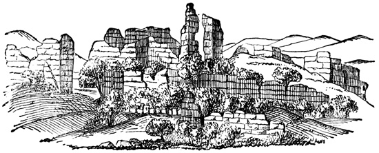
Casas Grandes—Chihuahua.
The ruined casas are about half a mile from the modern Mexican town of the same name, located in a finely chosen site, commanding a broad view over the fertile valley of the Casas Grandes or San Miguel river, which valley—or at least the river bottom—is here two miles wide. This bottom is bounded by a plateau about twenty-five feet higher, and the ruins are found partly on the bottom and partly on the more sterile plateau above. They consist of walls, generally fallen and crumbled into heaps of rubbish, but at some points, as at the corners and where supported by partition walls, still standing to a height of from five to thirty feet above the heaps of débris, and some of them as high as fifty feet, if reckoned from the level of the ground. The cuts on this and the opposite pages represent views of the ruins from three different standpoints, as sketched by Mr Bartlett.
CASAS GRANDES.
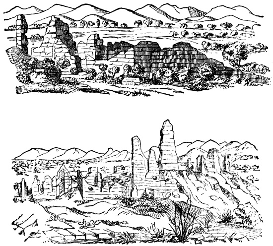
Casas Grandes—Chihuahua.
The material of the walls is sun-dried blocks of mud and gravel, about twenty-two inches thick, and of irregular length, generally about three feet, probably formed and dried in situ. Of this material and method of construction more details will be given in the following chapter on the New Mexican region, where the buildings are of a similar nature. The walls are in some parts five feet thick, but were so much damaged at the time of Mr Bartlett's visit that nothing could be ascertained, at least without excavation, respecting their finish on either surface. The author of the account in the Album states that the plaster which covers the blocks is of powdered stone, but this may be doubted. There is no doubt, however, that they were plastered on both interior and exterior, with a composition much like that of which the blocks were made; Escudero found some portions of the plaster still in place, but does not state what was its composition. The remains of the main structure, which was rectangular in its plan, extend over an area measuring about eight hundred feet from north to south, and two hundred and fifty from east to west.[X-66] Within this area are three great heaps of ruined walls, but low connecting lines of débris indicate that all formed one edifice, or were at least connected by corridors. On the south the wall, or the heaps indicating its existence, is continuous and regular; of the northern side nothing is said; but on the east and west the walls are very irregular, with many angles and projections.
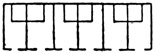
Ground Plan—Casas Grandes.
The ground plan of the whole structure could not be made out, at least in the limited time at Mr Bartlett's disposal. He found, however, one row of apartments whose plan is shown in the cut. Each of the six shown is ten by twenty feet, and the small structure in the corner of each is a pen rather than a room, being only three or four feet high. In the Album, the usual dimensions of the rooms are given as about twelve and a half by sixteen and a half feet; one very perfect room, however, being a little over four feet square. Bartlett found many rooms altogether too small for sleeping apartments, some of great size, whose dimensions are not given, and several enclosures too large to have been covered by a roof, doubtless enclosed courtyards. One portion of standing wall in the interior had a doorway narrower at the top than at the bottom, and two circular openings or windows above it. The explorer of 1842 speaks of doorways long, square, and round, some of them being walled up at the bottom so as to form windows.
Not a fragment of wood or stone remained in 1851; nor could any holes in the walls be found which seemed to have held the original floor-timbers; and consequently there was no way of determining the number of stories. In 1842, however, a piece of rotten wood was found, over a window as it seems; and the people in the vicinity said they had found many beams. No traces of any stairway was, however, visible. No doubt the earlier accounts spoke of wooden stairways, or ladders, because such means of entrance were commonly used in similar and more modern buildings in New Mexico; later writers converted the conjectures of the first visitors into actual fact; hence the galleries of wood and exterior stairways spoken of by Wizlizenus and others.
It is difficult to determine where the idea originated that the structure had three stories; for the walls still standing in places to a height of fifty feet, notwithstanding the wear of three centuries at least, would certainly indicate six or seven stories rather than three. These high walls are always in the interior, and the outer walls are in no part of a sufficient height to indicate more than one story. The general idea of the structure in its original condition, formed from the descriptions and views, is that of an immense central pile—similar to some of the Pueblo towns of New Mexico, and particularly that of Taos, of which a cut will be given in the following chapter—rising to a height of six or seven stories, and surrounded by lower houses built about several courtyards, and presenting on the exterior a rectangular form. Notwithstanding the imperfect exploration of this ruin and its advanced state of dilapidation, the reader of the following chapter will not fail to understand clearly what this Casa Grande was like when still inhabited; for there is no doubt that this building was used for a dwelling as well as for other purposes, and this may be regarded as the first instance in the northward progress of our investigation where any remains of authentic aboriginal dwellings have been met.
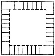
Ground Plan—Casas Grandes.
BROKEN POTTERY.
About one hundred and fifty yards west of the main building and somewhat higher on the plateau, are seen the foundations of another structure of similar nature and material, indicating a line of small apartments built round an interior court, according to the ground plan shown in the cut, the whole forming a square with sides of about one hundred and fifty feet. There are some other heaps in the vicinity which may very likely represent buildings, of whose original forms, however, they convey no idea, besides some remains of what seemed to Mr Bartlett to be very evidently those of modern Spanish buildings. Between the two buildings described there are three mounds or heaps of loose stones each about fifteen feet high, which have not been opened. Escudero, followed by García Conde, states that throughout an extent of twenty leagues in length and ten leagues in width in the valleys of the Casas Grandes and Janos, mounds are found in great numbers—over two thousand, as estimated in the Album—and that such as have been opened have furnished painted pottery, metates, stone axes, and other utensils. One visitor thought that one of the mounds presented great regularity in its form and had a summit platform.
Pottery from Casas Grandes.
Pottery from Casas Grandes.
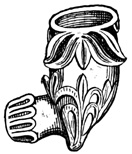
Pipe from Casas Grandes.
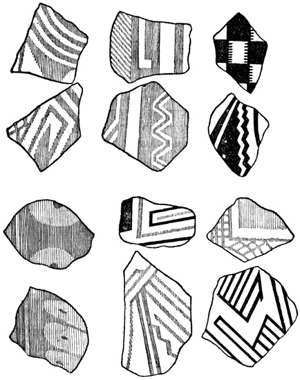
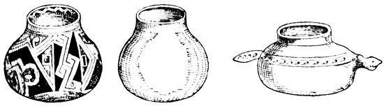
Escudero and Hardy report the existence of an aqueduct or canal which formerly brought water from a spring to the town. The following cut shows specimens of broken pottery found in connection with the ruins. The ornamentation is in black, red, or brown, on a white or reddish ground. The material is said to be superior in texture to any manufactured in later times by the natives of this region. The whole valley for miles around is strewn with such fragments. Unbroken specimens of pottery are not abundant, as is naturally the case in a country traversed continually by roving bands of natives to whom it is easier to pick up or dig out earthen utensils than to manufacture or buy them. Three specimens were however found by Mr Bartlett, and are shown in the cut. Mr Hardy also sketched a vase very similar to the first figure of the cut, and he speaks of "good specimens of earthen images in the Egyptian style, which are, to me at least, so perfectly uninteresting, that I was at no pains to procure any of them." According to the Album, some idols had been found by the inhabitants among other relics, and the women claimed to have discovered a monument of antiquity which was of practical utility to themselves, as well as of interest to archæologists—namely, a jar filled with bear's grease! The pipe shown in the cut, has a suspiciously modern look, although included in Bartlett's plate of Chihuahuan antiquities.
FORTRESS AT CASAS GRANDES.
The inhabitants pointed out to Bartlett, on the top of a high mountain, some ten miles south-west of the ruins described, what they said was a stone fortress of two or three stories. Escudero describes this monument, which he locates at a distance of only two leagues, as a watch-tower or sentry-station on the top of a high cliff; and says that the southern slope of the hill has many lines of stones at irregular intervals, with heaps of loose stones at their extremities. This is probably, in the absence of more definite information the more credible account. The Album represents this monument as a fortress built of great stones very perfectly joined, though without the aid of mortar. The wall is said to be eighteen or twenty feet thick, and a road cut in the rock leads to the summit. At this time, 1842, the works were being destroyed for the stone they contained. Clavigero speaks of the hill works as "a fortress defended on one side by a high mountain, and on other sides by a wall about seven feet thick, the foundations of which yet remain. There are seen in this fortress stones as large as millstones; the beams of the roofs are of pine, and well worked. In the centre of the vast edifice is a mound, built as it seems, for the purpose of keeping guard and watching the enemy." Clavigero evidently confounds the two groups of ruins, and from his error, and a similar one by others, come the accounts which represent the Casas Grandes as built of stone. He mentions obsidian mirrors among the relics dug up here, probably without any authority. The cut from Bartlett shows a stone metate found among the ruins.
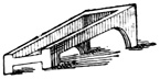
Metate from Casas Grandes.
So far as any conclusions or comparisons suggested by this Chihuahuan ruin are concerned, they may best be deferred to the end of the following chapter. The Casas Grandes, and the ruins of the northern or New Mexican group, should be classed together. They were the work of the same people, at about the same epoch.