Volume 4 — CHAPTER VII. ANTIQUITIES OF OAJACA AND GUERRERO.
Reading edition
Nahua Antiquities—Home of the Zapotecs and Miztecs—Remains in Tehuantepec—Fortified Hill of Guiengola—Petapa, Magdalena, and Laollaga—Bridge at Chihuitlan—Cross of Guatulco—Tutepec—City of Oajaca and Vicinity—Tlacolula—Etla—Peñoles—Quilapan—Ruins of Monte Alban—Relics at Zachila—Cuilapa—Palaces of Mitla—Mosaic Work—Stone Columns—Subterranean Galleries—Pyramids—Fortifications—Comparison with Central American Ruins—Northern Monuments—Quiotepec—Cerro de las Juntas—Tuxtepec—Huahuapan—Yanguitlan—Antiquities of Guerrero.
NAHUA MONUMENTS.
I now enter what has been classified in a preceding volume of this work as the home of the Nahua nations,—nations, most of which were at the time of the Spanish conquest, and during the preceding century, subjected to the allied powers of Anáhuac, and were more or less closely related to the nations of the central valley, in blood, language, or institutions. It has been seen, in what has been said on the subject,[VII-1] that the dividing line between the Nahuas and Mayas, drawn across the isthmus of Tehuantepec, is not a very sharply defined one. Many analogies, linguistic, institutionary, and mythologic, were found between nations dwelling on different sides of the line; so in monumental relics, and in traditional history, we shall find many points of similarity; but on the whole, the resemblances will be so far outweighed by the differences, as "to indicate either a separate culture from the beginning, or what is more probable, and for us practically the same thing, a progress in different paths for a long time prior to the coming of the Europeans," to repeat the words of a preceding chapter.
The relics to be described in the present chapter are those of the isthmus proper, and of that portion of the Mexican Republic above the isthmus which lies in general terms south of the eighteenth parallel of latitude, including the states of Oajaca and Guerrero, and stretching on the Pacific from Tonalá to the mouth of the Rio Zacatula, a distance of between five and six hundred miles. The province of Tehuantepec, belonging politically to the state of Oajaca, includes the central continental mountain chain, with the plains on the Pacific at its southern base, a region somewhat less fertile and attractive than those in which many of the ruins already described are situated. The two chief mountain ranges of the Mexican Republic, one skirting the Atlantic, the other the Pacific shore, draw near each other as the continent narrows, and meet in Tehuantepec. The southern portions of these two converging ranges, the broad mountain-girt valleys in the angle formed by their junction, and a narrow strip of tierra caliente on the southern coast, constitute the state of Oajaca, the home of the Miztecs, Zapotecs, and other tribes somewhat less civilized, powerful, and celebrated. The interior valleys are for the most part in the tierra templada, and include some of the best agricultural land in the country, with all the larger towns grouped round the capital as a centre. Guerrero is made up of the very narrow lowlands of the coast, the southern mountain range extending through its whole length from north-west to south-east, and the valley of the Zacatula further north. It is a region but little known to travelers, except along the great national highway, or trail, which leads from Acapulco, the most important port of the state, to the city of Mexico.
RUINS OF GUIENGOLA.
Five or six leagues from the city of Tehuantepec, the capital of the province of the same name, and in the south-western corner of the province, have been found the remains of an aboriginal fortification or fortified town, which, according to the traditional annals of the country, was built by the Zapotecs, not very long before the Conquest, to resist the advance of the Aztec forces. The principal remains are on a lofty hill, the cerro of Guiengola, but the fortified territory is said to extend over an area measuring one and a half by over four leagues, the outer walls being visible throughout the entire circumference at every naturally accessible point. Besides the protecting walls there are remains of dwellings, all of stone without mortar, except a cornice on the larger walls. Three fortresses covered with a coating of hard plaster are mentioned. Ditches accompany the walls and add to the strength of the works. From a subterranean sepulchre were taken about two hundred pieces of pottery, including vases and imitations of various animals. The tombs had a coating of compact cement, and the skeletons found in them were lying face down. The preceding information I take from a very vague account written by Sr Arias and published in the Museo Mexicano. Arias visited the locality in 1833; he claims to have sent some very interesting relics, found at Guiengola and other localities in the vicinity of Tehuantepec, to the museum at Oajaca; but the man to whom they were entrusted probably disposed of them in a manner more profitable to himself, if less advantageous to the museum. Several natural caves are spoken of by Arias, and one of them, seventy feet deep, showed traces, according to the German traveler Müller, of having been formerly inhabited. The latter also found vestiges of dwellings scattered throughout the vicinity, and speaks of a well-preserved tumulus standing not long before his visit in a valley close by. It was thirty-three feet high, with a base of ninety by one hundred and five feet, and a summit platform sixty by seventy-five feet, reached by a stairway of twenty-five wide steps. At the side of this tumulus was a quadrilateral elevation covering an area of about two acres, and enclosed by a wall eight feet high and twelve feet thick. Whether these structures are identical with the 'castles' of Arias is uncertain. A correspondent of Hutchings' Magazine in 1858 describes a wall of rough stones four feet thick and thirty feet high, said to extend nine miles. This writer speaks also of buildings with pillars in their centre, and of quarries from which the stone was originally taken. Some plans accompanied Arias' report but were not published. Unsatisfactory as it certainly is, the preceding is all the information extant respecting these remains,[VII-2] or at least referred definitely to Guiengola by name; but some remains were described by Dupaix and sketched by Castañeda, at a point three leagues west of Tehuantepec, which undoubtedly belonged to this group, and were probably the same ruins which the other writers so vaguely mention. On the top of a high hill, surrounded by other grand ruins, are two pyramids of hewn stone and mortar. The first is fifty-five by one hundred and twenty feet at the base, and thirty by sixty-six feet at the summit. The main stairway, thirty feet wide, of forty steps, leads up the centre of the western slope; there are also narrower stairways on the north and south. The pyramid is built in four terraces, the walls of the lower one being perpendicular; and of all the rest sloping. The whole surface was covered with a brilliant cement of lime, sand, and red ochre. No remains whatever were found on the summit. A remarkable feature is noticed on the surface of the second story, from which project throughout the whole circumference, except where interrupted by the stairways, four ranges of flat stones, forming hundreds of small shelves. The only suggestions made respecting the possible use to which these shelves were devoted are that they supported torches or human skulls.
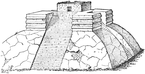
Pyramid near Tehuantepec.
The second pyramid is shown in the accompanying cut. The dimensions of the base and summit platform are about the same as those of the former pyramid, but the height is over fifty feet. The chief stairway, shown in the cut, is on the east, and narrower stairways also afford access to the summit on the north and south. The curved slope of the lower story constitutes a feature not found in American pyramids farther south, and rarely if at all in the north. The upper story has three projections, or cornices, on its perpendicular sides; and between them is set a row of blocks, said to be white marble, bearing sculptured designs in bas-relief. Three of these blocks with their sculptured figures, found by Castañeda at the foot of the pyramid, are shown in the cut. Of the building which appears on the summit nothing is known further than may be gathered from the cut. The sides of the pyramid were covered with cement, which was doubtless in a much more dilapidated condition than is indicated in the drawing.
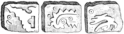
Marble Tablets from Tehuantepec.
Near the pyramids, and perhaps used in connection with them as an altar, is a structure comprised of eight circular masses of stone and mortar, like mill-stones in shape, placed one above another, and diminishing in size towards the top. The base is ten feet and a half in diameter, and the summit about four feet and a half, the height being about twelve feet. Kingsborough's translation, without any apparent authority, represents this monument as standing on a base sixty-six feet long and twelve feet high.
About a hundred paces in front of the second pyramid, stands a structure precisely similar to the lower story of that just described, twelve feet in diameter and three feet high. Both of these altar-like pyramids were built of regular blocks of stone, and covered with a hard white plaster. Dupaix suggests that the latter was a gladiatorial stone, or possibly intended for theatrical representations.[VII-3]
MONUMENTS OF TEHUANTEPEC.
In the city of Tehuantepec, or in its immediate vicinity, Dupaix found a flint lance-head of peculiar shape, having three cutting edges, like a bayonet. Its dimensions were one and a half by six inches, and the end was evidently intended to be fixed in a socket on the shaft. Cuts of four terra-cotta idols, sent to the Mexican Museum probably by Arias, already mentioned, are given in a Mexican magazine, and also in a Spanish edition of Prescott's work. Two of them wear horrible masks, the main feature of which is the projection from the mouth of six large tusks, like those of some fierce animal or monster. The same Arias speaks of a statue representing a naked woman, but broken in pieces; also a stone tablet covered with hieroglyphics. A small earthen bowl or censer, with a long handle, was presented to the American Ethnological Society, as coming from some point on the Tehuantepec interoceanic route.[VII-4]
In the region of Petapa, a town forty or fifty miles north of Tehuantepec, a stalactite cave is mentioned by Brasseur, on the walls of which figures painted in black are seen, including the imprint of human hands like those on the Yucatan ruins except in color. A labyrinth of caves, with some artificial improvements, is also reported, where the remains of princes and nobles were formerly deposited, and where an arriero claims to have seen over one hundred burial urns, painted and ranged in order round the sides of the cave.[VII-5] Only four leagues from Tehuantepec, near Magdalena, Burgoa speaks of a statue of Wixepecocha, the white-haired reformer and prophet of the Zapotecs, which Brasseur, without naming his authority, states to have been still visible a few years before he wrote.[VII-6] Lafond briefly mentions three pyramids on the isthmus without definitely locating them;—that of Tehuantepec, seventy-two feet high, that of San Cristóval near the former, and that of Altamia in a broad plain.[VII-7] At Laollaga, seven leagues from Tehuantepec in a direction not stated, Arias—very vaguely, as is the custom of Mexican and Central American explorers of local antiquities—describes a group of mounds, some of which are seventy or eighty varas square, built of stones—or stone adobes, as the author calls them—three feet long and half as thick. In connection with these mounds, flint and copper hatchets have been found, together with many anchor-shaped objects of what is spoken of as brass. A cave containing some relics was reported to exist in the same vicinity; and at another point, some fourteen leagues from the city, is a mound seventy-five feet high, on the side of which was discovered a black rock, covered with hieroglyphic characters.[VII-8] At Chihuitlan, a day's journey from the city, a bridge of aboriginal construction, stretches across a stream. The bridge is twelve feet long, six feet wide, and nine feet high above the water, having low parapets guarding the sides. The conduit is nine feet wide, and is formed by two immense stones, which meet in the centre. According to Castañeda's drawing these two stones have curved surfaces, so that the whole approaches in form a regular arch. The whole structure is of the class known as cyclopean, built of large irregular stones, without mortar.[VII-9]
Respecting Tehuantepec antiquities, I have in addition to what has been said only brief mention by Garay of the following reported relics: On a cliff of the Cerro del Venado, is the sculptured figure of a deer, whence comes the name of the hill. Nine miles east of the same hill the Indians pointed out the location of a valley where they said were the remains of a large town of stone buildings. The Cerro de Coscomate, near Zanatepec, is said to have a sculptured image of the sun, with an inscription in unknown characters. And finally, relics have been found on the islands of Monapostiac, Tilema, and Arrianjianbaj; those on the first being in the form of earthen idols, while in the latter were the foundations of an aboriginal town.[VII-10]
At the port of Guatulco, south-west from Tehuantepec on the Oajacan coast, there may yet be seen, if Brasseur's statement is to be credited, traces of the roads and buildings of the ancient city that stood in this locality, and transmitted its name to the modern town. Guatulco was likewise one of the many localities described by the early Catholic writers as containing a wonderful cross, left here probably by Saint Thomas during his sojourn in America. We are not very clearly informed as to the material of this relic, but we know, from the same authorities, that all the powers of darkness could not destroy it, not even the famous Englishman, Sir Francis Drake, who subjected it for three days to the fiercest flames without affecting its condition. Brasseur also tells us that the remains of Tututepec, a great aboriginal south-coast capital, are still to be seen three or four leagues from the sea, between the Rio Verde and Lake Chicahua.[VII-11]
MISCELLANEOUS REMAINS.
Passing now to the interior valleys about the capital city of Oajaca, where the chief remains of aboriginal works are found, I shall mention first a few miscellaneous relics of minor importance, or at least only slightly known to explorers,[VII-12] beginning with the city of Oajaca, where Dupaix found two ancient ornaments of great beauty. The first was a pentagon of polished transparent agate, about two inches in diameter and an inch and a half thick. The surface bore no marks of the instruments by which it was polished, and a hole was bored through the stone presumably for the insertion of a string. The second was a hexagonal piece of black touch-stone, of about the same dimensions, sprinkled with grains of gold or copper, and like the former brilliantly polished. The hole in this stone was bored in the form of a curve, by an unknown process which must have been accompanied by no little difficulty.[VII-13]
At Tlacolula, some twenty miles south-east of Oajaca, Mr Müller reports the opening of a mound twelve feet high and eight feet in diameter at the base. It was simply a heap of earth, and the only artificially wrought objects found in the excavations were an earthen tube two inches in diameter and nearly two feet long, closed at each end with a stone plug, found in a horizontal position somewhat above the natural surface of the ground, and a bowl-shaped ring of the same material lying in a vertical position over the tube near the centre of the mound, but separated from the first relic by a layer of earth.[VII-14] Remains of the ruined fortress of Quíyechapa are said to have been seen by travelers at a point some twenty-five leagues east of Oajaca.[VII-15] At Etla, two leagues northward from the capital, two subterranean tombs were opened, and found to contain what are supposed to have been earthen torch-bearers, or images in distorted human form, with a socket in the head which indicates their former use. Similar images found at Zachila will be noticed later in this chapter. A wooden fac-simile of the tomb is mentioned by Sr Gondra as preserved in the Mexican Museum.[VII-16] At Peñoles, seven leagues from Oajaca, a skull covered and preserved by a coating of limestone was found.[VII-17] On the western boundary of this state, perhaps across the line in Guerrero, at Quilapan, formerly a great city of the Miztecs, an axe cast from red copper was found, one fourth of an inch thick, four inches long, and three and a half inches wide. From a mound opened in the same vicinity some fragments of statues and of pottery were taken.[VII-18] Fossey tells us that conical mounds in great numbers are scattered over the whole country between Oajaca, Zachila, and Cuilapa. The mounds are from fifteen to fifty feet high, and are formed in some cases of simple earth, in others of clay and stones. Human remains are found often in the centre together with stone and earthen figures. Those figures which are molded in human form agree in features with the Zapotec features of modern times. Copper mirrors and hatchets have also been found, according to this author, as well as golden ornaments and necklaces of gilded beads.[VII-19] M. Charnay saw in the second valley of Oajaca as he came from Mexico the ruins of a temple, the building of which was begun by the Spaniards in the time of Cortés, on the site of an aboriginal temple. The ruined walls of the latter were of adobes, and served for scaffolding in the erection of the former, and both ruins now stand together. The whole valley was covered with tumuli, probably tombs, as the author thinks; but the natives would neither help to make excavations nor permit strangers to make them.[VII-20]
In addition to the relics described in the few and unsatisfactory notes of the preceding pages, three important groups of antiquities in central Oajaca remain to be noticed: Monte Alban, Zachila, and Mitla; our information respecting the two former being also far from satisfactory.
RUINS OF MONTE ALBAN.
Monte Alban is located immediately west of the city of Oajaca, or Antequera, at a distance of from half a mile to five miles according to different authorities. These differences in the statements of the distance perhaps result from the fact that some visitors estimate it in an air line, while others include the windings of the road which must be traveled over a mountainous country in order to reach the ruins, which seem to be located on a high hill or on a range of hills overlooking the town. Dupaix and Castañeda visited this place during their second expedition. Juan B. Carriedo made in 1833 a manuscript atlas of plans and drawings of the remains, which has never been published, but which is said to be preserved in the Mexican Museum. José María García explored Monte Alban in 1855, and his report with some drawings was published in the bulletin of the Mexican Geographical Society. Müller, the German traveler, visited the place in 1857 with one Ortega, and published a plan in his work. Finally we have Charnay's description from an exploration in 1858 or 1859, unaccompanied, however, by photographic views.[VII-21]
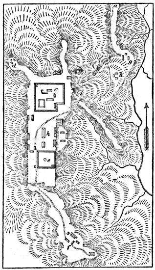
Plan of Ruins—Monte Alban.
Notwithstanding this array of authorities, which ought to give a clear idea of a single group of remains, the reader will find the following description very imperfect, since each of the visitors, as a rule, describes a different part of the ruins, and they do not often agree in their remarks on any one structure. The plan in the annexed cut is copied from that in Müller's work, and shows all the remains marked on the original, except four small structures on a northern continuation of the hill, or spur, a, shown in the north-eastern part of the plan. As the plan indicates, the ruins are situated on a plateau of some three hundred by nine hundred yards along the summit of a range of high hills with precipitous ascent, rising from the banks of a stream which Müller calls the Rio Xoxo. The works mentioned as not included in the plan, are described by Müller as the remains of four walls which form a parallelogram. All he tells us of the works at d and f, is that the terraces are covered with walls and embankments parallel or at right angles to each other. The structure at c is described as a pyramidal elevation fifty feet high and two hundred and fifty varas square at the base, from the summit platform of which rise a smaller terrace, or mound, at the north-west corner, and various other embankments and ruined walls not particularly described, but indicated on the plan. The structures in the central portion of the main plateau, at h, are spoken of as parallel embankments about thirty feet high.
To the ruins thus far mentioned no one but Müller refers definitely, although others speak somewhat vaguely of the ruined embankments and walls that cover the whole surface of the plateau. Only the southern remains at e seem to have attracted the attention of all. These Müller briefly represents as an embankment fifty feet high, enclosing a quadrilateral space, on which embankment were two pyramids or mounds. One of the latter was proved by excavating to have no interior apartments or galleries; the other was penetrated at the base by galleries at right angles with each other, and leading to a central dome-shaped room, the top of which had fallen. García represents the square court as enclosed, not by a continuous embankment, but by four long mounds, having a slight space between them at the ends. The southern mound is the largest of the four, being about forty-five feet high, and, according to García's plan, about twelve hundred feet long and three hundred feet wide. It seems, from the drawings, to be nothing but a simple heap of earth and rough stones, although the slopes of the sides and ends were doubtless regular originally, perhaps even faced with masonry, and there are traces of a stairway leading up to the summit platform from the court. On the summit of the mounds, and also in the court, are many conical mounds, four of which were particularly noticed. These mounds were the only remains on the plateau of Monte Alban which attracted the attention of Dupaix and Castañeda, and are represented by them as heaps of rough stones, in some cases with mortar, covered on the exterior with cement, and traversed at the base by galleries, the sides of which are faced with hewn blocks. García says the mounds are about twenty-four feet high; but Dupaix calls one forty feet, another sixty, and a third still higher.
One of the mounds stands at the head of the stairway from the court, and the gallery through it at the base is described by García as having a bend in the centre, being six feet high, wide enough for two persons, and according to the plate, surmounted by large inclined blocks of stone resting against each other and forming an angle at the summit. Dupaix describes one of the mounds as traversed from north to south by a gallery nine feet high and six feet wide, which makes a turn, or elbow, near the centre, thus forming a room about twelve feet square and of the same height. The two mounds may very likely be identical, for although Castañeda's plate represents a regular curved arch, Kingsborough's copy has the pointed arch of large stones. Another of these artificial stone hills, according to Dupaix, has in the centre a room eighteen feet square, and thirty feet high, with a semicircular or dome-like top, the surface being formed of hewn stone. From the centre of each side a gallery thirty feet long, seven and a half feet high, and four feet and a half wide, with a regular arch, leads to the open air. The whole is said to be built on a large rectangular base of masonry, the dimensions of which are not given. García mentions a similar mound, but speaks of the central room as being circular.
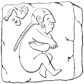
Sculptured Profile from Monte Alban.
Another of these structures, resembling at the time of Dupaix's visit a natural hill covered with trees, is sixty feet high, and has a gallery seven and a half feet high and six feet wide, with arched top, extending seventy-eight feet, or nearly the whole diameter from south to north. The left hand, or western, wall of the gallery is composed of granite blocks, generally about twenty-eight by thirty-six inches and eighteen inches thick, on the surface of which are sculptured naked human figures in profile facing northward toward the interior of the mound. Four of these figures were sketched by Castañeda, and one of them, from whose head hangs something very like a Chinese queue, is shown in the cut. García locates this mound or another very similar one in the court, and he also sketched some of the figures, but very slight if any resemblance can be discovered between his drawings and those of Castañeda. Müller speaks of one of the tablets the sculptured design of which represents a woman giving birth to a ball. García states that human bones and fragments of pottery have been dug from these ruins, Dupaix found some bones, and M. Lenoir suggests that the figures in bas-relief were portraits of persons buried in the tombs. Dupaix mentions a fourth mound similar to the others, having an angular ceiling, and a pavement of lime and sand.
Charnay describes the plateau as being partially artificial, and as covering about one half a square league, covered with masses of stone and mortar, forts, esplanades, narrow subterranean passages, and immense sculptured blocks. The arches of the galleries, contrary to Dupaix's statements, are formed by large inclined blocks. The grandest ruins are at the south end of the plateau; they are mostly square truncated pyramids, about twenty-five feet high, and having steep sides. Enormous masses of masonry represent what once were palaces, temples, and forts.[VII-22]
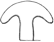
Aboriginal Coin from Monte Alban.
RELICS AT MONTE ALBAN.
Three smooth cubical stones, seven and a half feet high, four and a half feet wide, and eighteen inches thick, of granite, according to García, but of red porphyry, in the opinion of Müller, were found during the ascent of the hill, perhaps at b, or g, of the plan. Two of the stones were standing close together, while the third had fallen; all are supposed to have formed an altar or pedestal.[VII-23] At the southern brink of the plateau Müller found a crumbling stone covered with hieroglyphics. On the slope of the hill, stones covered with sculptured hieroglyphics were noticed by Dupaix, also at the western base long cubes, some plain and others sculptured. One of the latter six feet long, four feet and a half wide, and eighteen inches thick, was sketched by Castañeda, together with a circular stone three varas and a half in circumference. His plates also include a semi-spherical mirror of copper-covered lava, three and a half inches in diameter, with beautifully polished surface and a hole drilled through the back; a copper chisel, seven inches long and one inch in diameter; and finally, the cast copper implement shown in the preceding cut, one of two hundred and seventy-six of the same form, but of slightly varying dimensions, which were found in an earthen jar dug up in this vicinity. The dimensions of the one shown in the cut are about eight by ten inches. Pieces of copper of this form were used by the Nahua peoples for money, and such was doubtless the purpose of these Oajacan relics. A precisely similar article from one of the Mexican ruins lies before me as I write. Charnay states that the plateau is covered with fragments of very fine pottery, on which a brilliant red glazing is observable. He states further, that an Italian explorer, opening some of the mounds, found necklaces of agate, fragments of worked obsidian, and even golden ornaments of fine workmanship.
Respecting these ruins Charnay says: "Monte Alban, in our opinion, is one of the most precious remains, and very surely the most ancient, of the American civilizations. Nowhere else have we found these strange profiles so strikingly original." He pronounces the arch similar to that employed in Yucatan, but this opinion does not agree with his description on another page, where he represents the ceilings of the galleries as formed of large inclined blocks of stone. Viollet-le-Duc gives a cut indicating the latter form of arch; and I think there can be no doubt that Dupaix and Castañeda are wrong in representing semicircular arches. M. Viollet-le-Duc deems the sculpture different in type from that at Palenque but very similar to the Egyptian. He regards the works as fortifications and speaks of the galleries as penetrating the ramparts. Müller and García also deem the remains those of fortifications, while Ortega seeks to form them into a stately capital full of royal palaces, temples, and fine edifices. García tells us that these works were erected by a Zapotec king, with a view to resist the advance of the Miztecs; while Brasseur believes that here was the fortress of Huaxyacac built by the Aztecs about the year 1486, and garrisoned to keep the country in subjection.[VII-24]
It seems to me that the preceding description, imperfect as it is, is yet more than sufficient to prove that the structures on Monte Alban were never erected by any people as temporary works of defense. The choice of location shows, however, that facility of defense was one of the objects sought by the builders, and renders it very improbable that a city proper ever stood here, where, at least in modern times, there are no springs of water. On the other hand, the conical mounds as represented by Castañeda's drawings seem in no way fitted for defensive works, and were almost certainly erected as tombs of Zapotec nobles or priests. The plateau was probably in aboriginal times a strongly fortified holy place, sacred to the rites of the native worship, but serving perhaps as a place of refuge to the dwellers in the surrounding country when threatened by an advancing foe. It is moreover very likely that in the period of civil strifes and foreign invasions which preceded the Spanish Conquest, these works were strengthened and occupied by the Zapotecs, and possibly by the Aztecs also in their turn, as a fortress.
RELICS AT ZACHILA.
Zachila, ten or twelve miles, according to the maps, southward from Oajaca, was the site of a great Zapotec capital. A writer in a Mexican magazine mentions the base of an ancient pyramid as still visible near the church of the modern town. With the exception of this brief mention all our information respecting the antiquities of Zachila comes from the work of Dupaix; and this writer, so far as permanent monuments are concerned, only speaks generally of an immense group of mounds in conical form, built of earth and a few stones, and of the imprint of a gigantic foot probably marking the meridian somewhat south of the mounds. From excavations in these tumuli, stone and clay statues, or idols, were obtained, together with pottery, burnt bricks, pieces of human bones, and fragments of ruined walls. Of the objects taken from the tumuli or found in the vicinity, over twenty were described and sketched by Dupaix and Castañeda.
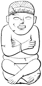
Stone Statue from Zachila.
1. A seated human figure with arms and legs crossed as shown in the cut. It is carved from a grayish yellow grindstone-like material, and is about a foot in height. It was found in a tomb together with some human bones. The rear view in the original shows the hair falling down the back and cut square across; while the belt about the waist is passed between the legs and is tied in a knot behind. 2. A seated human figure in granite, eighteen inches high. The arms, from elbow to wrist, are free from the body, and the hands rest on the knees. A string of beads or pearls is suspended from the neck, and a mask with fantastic figures in relief covers the face. In the top of the head is a hollow, and the image seems to have been designed, like many others in the same locality, for a vase or, perhaps, a torch-bearer. 3. A seated human figure, twenty-seven inches high, cut from white marble and painted red. The arms and body are concealed by a kind of semicircular cape. The hands appear below the cape, holding some indescribable object. A necklace of beads or pearls surrounds the neck, the face is apparently masked or at least the features are ideally fantastic, and an immense headdress, as large as all the rest of the figure, surmounts the whole in semicircular form. A serpent appears among the emblems of the head-dress.[VII-25] 4. A stone twenty-seven inches long, twelve inches high, and three inches thick, of very hard and heavy material. On one side, within a plain border, are four human figures in low relief, two on each side facing a kind of altar in the middle. All are squatting cross-legged, one has clearly a beard, and another has a bird—called by Dupaix an eagle, as is his custom respecting every bird-like sculpture—forming a part of his head-dress. The stone was badly broken, but seems to have been carried by the finder to Mexico.[VII-26] 5. A bird bearing considerable likeness to an eagle, holding a serpent in its beak and claws. This figure was sculptured in low relief on a block of hard sandstone three feet square, built into a modern wall. 6. A human face, much like what is in modern times drawn to represent the full moon, three feet in diameter, and also built into a wall. The material is a brilliant gray marble. 7. Three fragments with sculptured surfaces, one of which has among other figures several that seem to represent flowers. 8, 9. Two masked images, similar in some respects to No. 2, but of terra-cotta instead of stone. One of them is shown in the cut. They are about a foot and a half high, hollow, and present some indications, in the form of a socket at the back of the head, of having been intended to hold torches.[VII-27] 10. A terra-cotta figure, about nine inches high, apparently representing a female clad in a very peculiar dress, as shown in the cut.[VII-28] 11. An earthen cylinder, five inches in diameter and nine inches high, on the top of which is a head, possibly the caricature of a dog, from whose open jaws looks out a tolerably well-formed human face. 12-17. Six heads of animals or monsters in terra cotta. 18-23. Six earthen dishes of various forms, one of which, in the form of a platter, has within it a representation in clay of a human skull.
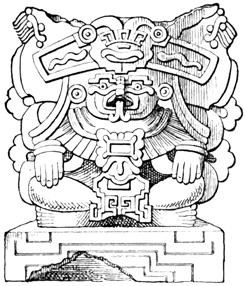
Terra-Cotta Image—Zachila.
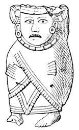
Terra-Cotta Image—Zachila.
A tomb is said to have been opened at Zachila in which were several tiers of earthen platters, each containing a skull. Some of the vessels have hollow legs with small balls, which rattle when they are moved.[VII-29] At Cuilapa, some distance north-east of Zachila, the existence of tumuli is mentioned, but a German explorer, who visited the locality with a view to open some of them, is said to have been stoned and driven away by the infuriated natives, notwithstanding the fact that he was provided with authority from the local authorities.[VII-30]
MITLA—HOME OF THE DEAD.
The finest and most celebrated group of ruins in Oajaca, probably the finest in the whole Nahua territory, is that at Mitla, about thirty miles slightly south of east from the capital, and eight or nine miles north-east of Tlacolula. Here was a great religious centre often mentioned in the traditional annals of the Zapotecs. The original name seems to have been Liobaa, or Yobaa, 'the place of tombs,' called by the Aztecs Miquitlan, Mictlan, or Mitla, 'place of sadness,' 'dwelling of the dead,' often used in the sense of 'hell.'[VII-31] The buildings at Mitla were at least partially in ruins when the Spaniards came, but their dilapidation probably dated only from the fierce contests waged by the Zapotec kings against the Aztec powers in Anáhuac, during one or two centuries preceding the Conquest; and as we shall see later there is no reason whatever to doubt that the place was occupied by the Zapotec priesthood during the long period of that nation's supremacy in Oajaca and the southern Anáhuac.[VII-32]
The gloomy aspect of the locality accords well with the dread signification of its name. The ruins stand in the most desolate portion of central Oajaca, in a high, narrow valley, surrounded by bare and barren hills. The soil is a powdery sand, which supports no vegetation save a few scattered pitahayas, and is borne through the air in clouds of dust by the cold dry wind which is almost continually blowing. A stream with parched and shadeless banks flows through the valley, becoming a torrent in the rainy season, when the adjoining country is often flooded. No birds sing or flowers bloom over the remains of the Zapotec heroes, but venomous spiders and scorpions are abundant. Yet a modern village with few inhabitants stands amid the ruins, and the natives go through forms of worship in honor of a foreign deity in a modern church over the tombs of their ancestors' kings and priests, whose faith they were long since forced to abandon.[VII-33]
EXPLORATION OF MITLA.
Most of the early Spanish chroniclers speak of Mitla and of the traditions connected with the place, but what may be called the modern exploration of the structures, as relics of antiquity, dates from the year 1802, when Don Luis Martin and Col. de la Laguna from Mexico visited and sketched the ruins. It was from Martin and from his drawings in the hands of the Marquis of Branciforte, that Humboldt obtained his information. In August 1806, Dupaix and Castañeda reached Mitla in their second exploring tour. In 1830, the German traveler Mühlenpfordt, during a residence in the country, made plans and drawings of the remains, copies of which were retained by Juan B. Carriedo and afterwards published in a Mexican periodical. Drawings were also made by one Sawkins in 1837, and published by Mr Brantz Mayer in a work on Zapotec antiquities. M. de Fossey was at Mitla in 1838, but his description is made up chiefly from other sources. Sr Carriedo, already mentioned, wrote for the Ilustracion Mejicana, a statement of the condition of the ruins in 1852, with measures which had been, or ought to be, taken by the government for their preservation. Mr Arthur von Tempsky spent part of a day at the ruins in February, 1854, publishing a description with several plates in the account of his Mexican travels which he named Mitla. José María García saw the ruins in October, 1855, as is stated in the bulletin of the Mexican Geographical Society, but no description resulted from his exploration. Finally Charnay came in 1859, and succeeded after many difficulties in obtaining a series of most valuable and interesting photographs.[VII-34]
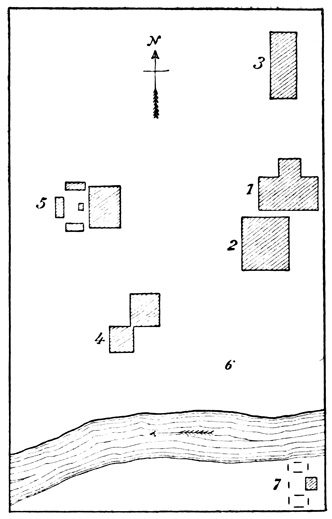
General Plan of Mitla.
The number of ruined edifices at Mitla is variously stated by different authors, according to their methods of counting; for instance, one explorer reckons four buildings enclosing a court as one palace, another as four. The only general plan ever published is that made by Mühlenpfordt, and published by Carriedo, from which the annexed cut was prepared.[VII-35] Most of the visitors, however, say something of the bearing of some of the buildings from the others, and there are only very few instances where such remarks seem to differ from the plan I have given. The structures usually spoken of as palaces or temples, are four in number, marked 1, 2, 3, and 4; 5 and 7 are pyramids, mounds, or altars; and 6 shows the position of the houses in the modern village.
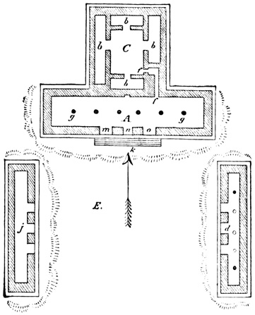
Ground Plan of Palace No. 1.
GRAND PALACE.
I begin with the best preserved of all, palace No. 1 of the plan.[VII-36] The arrangement of its three buildings is shown in the accompanying ground plan, a reduction from Castañeda's drawing. Three low oblong mounds, probably of rough stones, only five or six feet high, enclose on the east, north, and west, a court, E, whose dimensions are in general terms one hundred and twenty by one hundred and thirty feet, and each of the mounds supports a stone building. The walls of the northern building are still in a tolerable state of preservation; the eastern one has mostly fallen, and of that on the west only slight traces of the foundations remain. It is possible that originally there was a fourth mound, with or without its building, on the south.[VII-37]
The lateral buildings, d, j, are about nineteen by ninety-six feet on the ground. Of the northern building, the southern portion, A, is about thirty-six by a hundred and thirty feet, the northern portion, C, sixty-one feet square, and the whole not far from eighteen feet high, the walls being from four to nine feet in thickness.[VII-38] Other details will be readily learned from the plan. Three doorways open on the court from each building, and a broad stairway of few steps leads up to the doorways, at least on the north.
The southern wing of the northern building, A of the plan, may be first described, being the best known and one of the best preserved of all; and the structure of the walls naturally claims attention first. In Yucatan we have found a filling of rough stones and cement, faced on both exterior and interior with hewn blocks; at Palenque the walls are built entirely of hewn stone; at Mitla the mode of construction somewhat resembles that in Yucatan, but the filling seems to be clay, instead of cement, with an admixture of irregular stones, varying in quantity in different parts of the walls.[VII-39]
CONSTRUCTION OF WALLS.
The exterior facing of the wall is shown very clearly by the two following cuts, which represent the southern façade of the building, A, as seen from the court. The first cut I have reduced photographically from Charnay's original photograph; the second, showing the rest of the façade, was taken from the same photograph for Mr Baldwin's work. The facing is of stone blocks cut in different forms and sizes, placed against or in some cases slightly penetrating the inner filling. First, a double tier of very large blocks are placed as a base along the surface of the supporting mound, projecting two or three feet from the line of the wall, the stones of the upper tier sloping inward. On this base is erected a kind of frame-work of large hewn blocks with perfectly plain unsculptured fronts, which divide the surface of the wall into oblong panels of different dimensions. These panels are then filled with a peculiar mosaic work of small brick-shaped blocks of stone of different sizes, set in different positions, so as to form a great variety of regular patterns, usually spoken of as grecques.[VII-40] No mortar seems to have been employed in this facing of stone; at least its use is not mentioned by any author, and Dupaix states expressly that it is not found. Some of the blocks used in the base, frame-work of the panels, and lintels of the doorways, are very large. One of the latter is described by different writers as from sixteen to nineteen feet long, and is said by Dupaix to be of granite. The only sculpture on the façade is found on these lintels, the surface of which is represented as carved into regular figures in low relief, corresponding with the mosaic in the panels. The doorways are about seven feet wide and eight feet high, and in the upper part of the piers that separate them are noticed four round holes, which may be supposed, as in other aboriginal structures, to have served for the support of an awning, although the natives have a tradition that they were originally occupied by stone heads of native deities.[VII-41] The only other peculiarity to be noticed in this front is, that instead of being perpendicular, it inclines slightly outward from the base, as do many of the walls at Mitla.[VII-42]
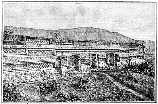
Façade of First Palace—Mitla.
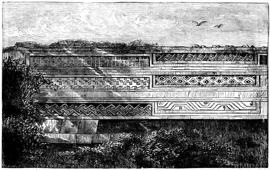
Façade of First Palace—Mitla.
STONE COLUMNS.
The interior of the building, A, has a pavement of flat stones covered with cement, which latter has mostly disappeared. The inner surface of the walls is of rough stones and earth, probably the same as the interior filling, and covered with a coat of plaster, a greater part of which remained in 1859, and is shown in Charnay's photograph; there were also traces of red paint on these walls in Dupaix's time. There are no windows, or other openings except the doorways; but on the northern wall, at mid-height, there is a niche, perhaps more than one, one or two feet deep, square in form, and enclosed by four blocks of stone. Extending in a line along the centre of this apartment, are six round stone pillars, g, g, of the plan, each about fourteen feet high, three feet in diameter, and cut from a single block of porphyry or granite. The tops are slightly smaller than the bases, and five or six feet of each stone, in addition to the height mentioned, are buried in the ground.[VII-43]
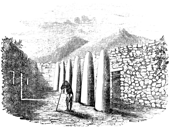
Interior—South wing of the First Palace.
The following cut I take from Baldwin's work, for which it was copied from one of Tempsky's plates. It is very faulty, as is proved by Charnay's photograph taken from the same point of view, in representing the walls as if built of large rough stones without mortar, in putting a doorway in the central part of the northern wall, and in making the columns diminish in size towards the top much more than is actually the case.[VII-44]
MOSAIC GRECQUES AT MITLA.
Passing now to the northern wing of this building, C, the exterior walls are the same in style and construction as those of the southern wing just described, as is proved by the photographic views.[VII-45] The court, C, is about thirty-one feet square, and its pavement was covered with cement, as that of the larger court, E, may have been originally. The ground plan shows the arrangement of the four apartments, b, b, b, b, although it is to be noted that other plans differ slightly from this in the northern and western rooms. The only entrance to the northern court and rooms is from the southern wing through the passage f, f, which is barely wide enough to admit one person. The interior façades, fronting on the court, are precisely like the southern façade of the southern wing, A, being made up of mosaic work in panels.[VII-46] The interior walls of the small apartments, b, b, b, b, unlike those of the southern apartment, A, are formed of mosaic work in regular and graceful patterns, except a space of four or five feet at the bottom, which is covered with plaster and bears traces of a kind of fresco painting in bright colors. The mosaic grecques or arabesques of the upper portions are arranged, not in panels as on the exterior, but in three parallel bands of uniform and nearly equal width, extending round the whole circumference of each room. The cut is a fac-simile from Charnay's photograph of one of these interiors, and gives an excellent idea of the three mosaic bands that extend entirely round each room.[VII-47]
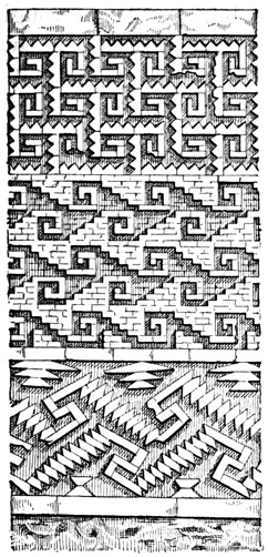
Grecques on Interior of Room at Mitla.
ROOF STRUCTURES.
I now have to speak of the roof which originally covered this building, since in the other buildings and palaces nothing will be found to throw any additional light on the subject. It seems evident that the columns in the southern wing were intended to support the roof, and if there were no contradictory evidence, the natural conclusion would be that the covering was of wooden beams stretching completely across the narrow apartments, and resting on the pillars of the wider ones, as we have seen to be the case at Tuloom, on the eastern coast of Yucatan.[VII-48] Burgoa, in whose time it is not impossible that some of the roofs may have been yet in place, tells us that they were formed of large stone blocks, resting on the columns, and joined without mortar.[VII-49] Humboldt states that the roof was supported by large sabino beams, and that three of these beams still remained in place (1802). According to Dupaix, both the roofs and floors in the northern wing were formed by a row of beams, or rather logs, of the ahuehuete, a kind of pine, a foot and a half in diameter, built into the top of the wall, and stretching from side to side. He does not inform us what traces he found to support his opinion. Mühlenpfordt[VII-50] found traces of a roof in one of the northern rooms sufficient to convince him that the original "consisted of round oak timbers, eight inches in diameter, placed across the room at a distance of eight inches one from another; these were first covered with mats, on which were placed stone flags, and over the latter a coat of lime; forming thus a solid and water-proof covering." Fossey speaks of one worm-eaten beam, but probably obtained his information from Humboldt. Tempsky, notwithstanding the shortness of his exploration, made the remarkable discovery that one of the northern rooms was still covered by a flat roof of stone. He also found windows in some of the buildings. What would he not have found had he been able to remain a few hours longer at Mitla? Viollet-le-Duc judges from the quantity and quality of the débris in the south wing, that the roof could not have been of stone in large blocks, but was formed by large beams extending longitudinally from pillar to pillar, and supporting two transverse ranges of smaller timbers, laid close together from the centre to either wall, the whole being surmounted by a mass of concrete like that which constitutes the bulk of the walls; and finally covered with a coating of cement. I have no doubt that this author has given a correct idea of the original roof structure, although in attempting to explain in detail the exact position which—'il y a tout lieu de croire'—each timber occupied, it is possible that the distinguished architect has gone somewhat beyond his data.[VII-51]
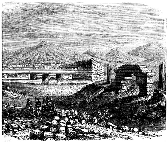
View from Court of Palace No. 1.
As I have said before, the western building of the palace No. 1—like the southern building, if any ever stood on the south of the court—has entirely fallen. Of the eastern building, d, there remain standing a small portion of the wall fronting on the court, including a doorway and its lintel, and also two of the five columns which occupied the centre of the building. The condition of this side structure seems not to have changed materially between Dupaix's and Charnay's visits, a period of over fifty years. The preceding cut, taken by Baldwin from Tempsky's work, gives a tolerably correct idea of what remains of it, except that the lintel had a sculptured front. It is a view from the south side of the court, and includes an imperfect representation also of the northern façade.[VII-52]
The palaces of Mitla are differently numbered by different writers, and much that has been written of them is so vague or confused that is difficult to determine in many cases what particular structure is referred to; I believe, however, that the preceding pages include all that is known of the palace numbered 1 on my general plan. I close my account of this palace by presenting on the opposite page a cut copied for Baldwin's work from one of Charnay's photographs, a general view of the ruins. The cut is a distant view of the palace No. 1 from the south-west, and cannot be said to add very materially to our knowledge respecting this building.[VII-53]
VIEW OF PALACE.
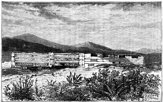
Distant View of Palace No. 1.
THE SECOND PALACE.
The remaining palaces of Mitla, Nos. 2, 3, and 4, may be more briefly disposed of, since in the construction of their walls they are precisely the same as No. 1, but are not in so good a state of preservation. No. 2 is located south-west of No. 1, and almost in contact with it, so that both groups have been by some visitors described together under the name of First Palace. It consists of four buildings, built on low mounds like those of No. 1, from seven to nine feet high, about a square court. All four are precisely the same in their ground plan, which is identical with that of the western building in palace No. 1. The dimensions of the four buildings are also the same, according to Castañeda's plan, being about eighteen by ninety-two English feet;[VII-54] but Mühlenpfordt's plan, so far as it can be understood, makes the eastern and western buildings about one hundred and forty feet long, the northern and southern being about twenty by one hundred feet, and the former somewhat larger than the latter.
The western building is the best preserved, being, so far as can be judged by human figures in Charnay's photographs, about seventeen feet high. The eastern building has fallen, and only its foundation stones remain by which to trace its plan. Three doorways open on the court from each building, and in the rear wall opposite the doors square niches are seen. There are no traces of columns in any of the apartments; nor was any part of the roofs in place in 1806. The outer walls are composed, as in palace No. 1, of oblong panels of mosaic; whether any mosaic work is found in the interior, is not stated. The court is said by Mühlenpfordt to be covered with a coating of cement five or six inches in thickness, painted red as was also the exterior of the buildings. The same writer, and Müller, noted that the supporting mounds were double, or terraced, on the exterior;[VII-55] and the latter, that one of the central doorways diminishes in width towards the top. If this, latter statement be true, it must be one of the doorways in the southern building, of which no photographic view was taken.[VII-56] Views of the southern façade of the northern building are given by Charnay, Dupaix, Mühlenpfordt, and Tempsky; of the court façade of the western building, by Charnay and Mühlenpfordt; and Charnay also took photographs of the western and southern façades of the latter building.[VII-57]
Under the northern building of this palace there is a subterranean gallery in the form of a cross. The entrance to this gallery is said by several writers to have been originally in the centre of the court, but this seems to rest on no very good authority, and it is not unlikely that the entrance was always where it is now, at the base of the northern mound, as shown in the photograph and in other views. The centre of the cross may be supposed to be nearly under the centre of the apartment above, and the northern, eastern, and western arms are each, according to Castañeda's drawings, about twelve feet long, five and a half feet wide, and six and a half feet high. The southern arm, leading out into the court is something over twenty feet long, and for most of its length only a little over four feet high; its floor is also several feet lower than that of the other arms, to the level of which latter four steps lead up. Nearly the whole depth of this gallery is probably in the body of the supporting mound rather than really subterranean. The top is formed of large blocks of stone, stretching across from side to side, and, according to Mühlenpfordt, plastered and polished. The floor was also covered, if we may credit Müller, with a polished coat of cement. The walls are panels of mosaic work like that found on the exterior walls above. Mühlenpfordt noticed that the mosaic work was less skillfully executed than on the upper walls, and therefore probably much older. The large dall that covers the crossing of the two galleries is supported by a circular pillar resting on a square base. According to Tempsky the natives call this the 'pillar of death,' believing that whoever embraces it must die shortly. The whole interior surface, sides, floor, and ceiling, are painted red. No relics of any kind have been found here. Fossey says that this gallery, or at least a gallery, leads from the palace to the eastern pyramid—meaning probably the western pyramid, No. 5 of the plan—and from that point still further westward, where it may be traced for a league to the farm of Saga, and extends, as the natives believe, some three hundred leagues. Tradition relates that the Zapotecs originally had their temples in natural caverns, which they gradually improved to meet their requirements, and over which they finally built these palaces. There are consequently many absurd rumors afloat respecting the extent of the subterranean passages, but nothing has ever been discovered to indicate the existence of natural caves or extensive artificial excavations at this point. At the time of Charnay's visit the opening to the gallery had been closed up, and the natives would allow no one to remove the obstructions, on the ground that hidden treasure was the object sought.[VII-58]
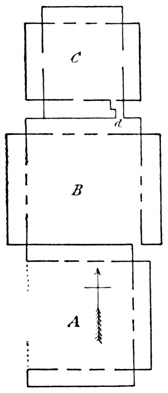
Ground Plan—Palace No. 3.
THIRD PALACE.
Palace No. 3 of the plan is said to have no supporting mound, but to stand on the level of the ground. Its ground plan, according to Castañeda, the only authority, is shown in the cut. The whole structure, divided into three courts, is about two hundred and eighty-four feet long and one hundred and eight feet wide, the thickness of the walls, not shown in the plan, being five or six feet. Nearly all the walls have fallen except those of the buildings about the central court, B, which have been repaired, covered with a roof of tiles, and are occupied by the curate of the parish as a residence. In the western front a doorway has been cut, before which, supporting a balcony, or awning, stand two stone columns which were evidently brought from some other part of the ruins. Both on the exterior and court walls, the regular panels of mosaic work are seen in the upper portions; the lower parts have been repaired with adobes, and newly plastered in many places. The modern church, quite a large and imposing structure, stands either upon or adjacent to a part of this ancient palace.[VII-59]
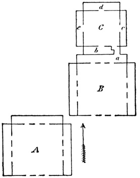
Ground Plan—Palace No. 4.
FOURTH PALACE, AND PYRAMIDS.
The cut is a ground plan of palace No. 4, which is also said to stand on the original level of the ground. The walls are spoken of by all visitors as almost entirely in ruins, and as presenting no peculiarities of construction when compared with the other palaces. From one of the portions still standing, however, Mühlenpfordt copied some fragmentary paintings, representing processions of rudely pictured human figures, as shown in the accompanying cut. The same author speaks of similar paintings, very likely not the work of the original builders of Mitla, on the walls of some of the other buildings.[VII-60]
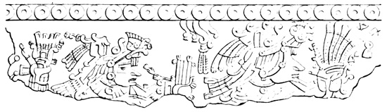
Painting on Doorway—Palace No. 4.
Two mounds, or groups of mounds, stand west and south of the other ruins at 5 and 7 of the plan. No. 5 was photographed by Charnay, and is described as built of adobes, ascended by a stone stairway, and bearing now a modern chapel. According to Castañeda's drawing probably representing these pyramids, the principal structure had four stories, or terraces, and was about seventy-five feet high, measuring at the base about one hundred and twenty feet on its shortest sides from east to west. The stairway faces westward towards the court formed by the smaller mounds which have only two stories. Group No. 7 is represented by Castañeda as consisting like No. 5 of a large mound and three small ones, of two and one stories respectively, surrounding a court in whose centre is a block, or altar, which Dupaix thinks may conceal the entrance to a subterranean passage. Mühlenpfordt represents the arrangement of the mounds as on my plan, and thinks the smaller elevations may have borne originally buildings like the northern palaces. In one of these mounds, according to the last-mentioned author, a tomb was found. Dupaix also describes two tombs found under mounds, the locality of which is not specified. One of these tombs was in the form of a cross, with arms about three by nine feet, six feet high, covered with a roof of flat stones, and in its construction like the gallery under palace No. 2, except that the small brick-shaped blocks of which its sides are formed are not arranged in grecques, but laid so as to present a plain surface. The second tomb was of rectangular form, about four by eight feet in dimensions. In one of them some human remains, with fragments of fine blue stone were discovered.[VII-61]
FORTIFIED HILL.
At a distance of a league and a half eastward of the village, Dupaix described and Castañeda sketched a small plain square stone building, divided into four apartments, standing on the slope of a high rocky hill. On the plate there is also shown the entrance to a subterranean gallery not mentioned in Dupaix's text.[VII-62] Three fourths of a league westward from the village is a hill some six hundred feet in height, with precipitous sides naturally inaccessible save on one side, toward Mitla. The summit platform, probably leveled by artificial means, is enclosed by a wall of stone about six feet thick, eighteen feet high, and over a mile in circumference, forming many angles, as is shown in the annexed plan. On the eastern and accessible side, the wall is double, the inner wall being higher than the outer; and the entrances are not only not opposite each other, but penetrate the walls obliquely. Heaps of loose stones, c, c, c, were found at various points in the enclosure, doubtless for use as weapons in a hand-to-hand conflict. Outside of the walls, moreover, large rocks, some three feet in diameter, were carefully poised where they might be easily started down the sides against the advancing foe. Within the fortress, at several places, d, e, f, g, are slight remains of adobe buildings, probably erected for the accommodation of the aboriginal garrison. All we know of this fortress is derived from the work of Dupaix and Castañeda.[VII-63]
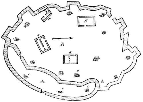
Plan of Fortress near Mitla.
Dupaix claims to have found the quarries which furnished material for the Mitla structures, in a hill three-fourths of a league eastward from the ruins, called by the Zapotecs Aguilosoé, by the Spaniards Mirador. The stone is described as of such a nature that large blocks may be easily split off by means of wedges and levers, and many such blocks were scattered about the place; the removal of the stone to the site of the palaces, here as in the case of many other American ruins, must have been the chief difficulty overcome by the builders. Stone wedges, together with axes and chisels of hard copper, are said to have been found at Mitla, but are not particularly described.[VII-64]
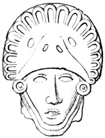
Head in Terra Cotta—Mitla.
A head in terra cotta, wearing a peculiar helmet, was sketched here by Castañeda, and is shown in the cut. Another terra-cotta image represented a masked human figure, squatting cross-legged with hands on knees. A large semicircular cape reaches from the neck to the ground, showing only the hands and feet in front. The whole is very similar to some of the figures at Zachila, already described, but the tube which may be supposed to have held a torch originally, projects above the head, and is an inch and a half in diameter. The only specimen of stone images or idols found in connection with the ruins, is shown in the cut. It represents a seated figure, carved from a hard red stone, and brilliantly polished. Its height is about four inches. Tempsky tells us that the children at Mitla offered for sale small idols of clay and sandstone, which had been taken from the inner palace walls.[VII-65]
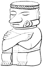
Stone Image from Mitla.
GENERAL REMARKS.
COMPARISONS.
The ruins of Mitla resemble Palenque only in the long low narrow form of the buildings, since the low supporting mounds can hardly be said to resemble the lofty stone-faced pyramids of Chiapas. A stronger likeness may be discovered when they are compared with the structures of Yucatan; since in both cases we find long narrow windowless buildings, raised on low mounds, and enclosing a rectangular courtyard, walls of rubble, and facings of hewn stone. The contrasts are also strong, as seen in the mosaic grecques, the absence of sculpture, and the flat roofs, in some cases supported by columns; although in one city on the east coast of Yucatan flat roofs of wooden beams were found. Whether the mosaic work of Mitla indicates in itself an earlier or later development of aboriginal art than the elaborately sculptured façades of Uxmal, I am unable to decide; but the flat roof supported by pillars would seem to indicate a later architectural development than the overlapping arch. The influence of the builders of Palenque and the cities of Yucatan, was doubtless felt by the builders of Mitla. How the influence was exerted it is very difficult to determine; Viollet-le-Duc attributes these northern structures to a branch of the southern civilization separated from the parent stock after the foundation of the Maya cities in Yucatan. Most antiquarians have concluded that Mitla is less ancient than the southern ruins, and the condition of the remains, so far as it throws any light on the subject, confirms the conclusion. This is the last ruin that will be found in our progress northward, which shows any marked analogy with the Maya monuments, save in the almost universal use of supporting mounds or pyramids, of various forms and dimensions. It has already been shown that the Zapotec language has no likeness whatever to the Aztec, or to the Maya, and that so far as institutions are concerned, this people might almost as properly be classed with the Maya as with the Nahua nations. The Abbé Brasseur in one part of his writings expresses the opinion that Mitla was built by the Toltecs from Cholula, who introduced their religion in Oajaca in the ninth or tenth century. Mitla is also frequently spoken of as a connecting link between the Central American and Mexican remains; this, however, is merely a part of the old favorite theory of one civilized people originating in the far north, moving gradually southward, and leaving at each stopping-place traces of their constantly improving and developing culture. There seems to have been no tradition among the natives at the Conquest, indicating that Mitla was built by a people preceding the Zapotecs. On the contrary, Burgoa and other early Oajacan chroniclers mention the place frequently as a Zapotec holy place, devoted to the burial of kings, the residence of a certain order of the priesthood, who lived here to make expiatory sacrifices for the dead, and a place of royal mourning, whither the king retired on the death of a relative. Subterranean caverns were used for the celebration of religious rites before the upper temples were built. Charnay fancies that the palaces were built by a people that afterwards migrated southward. He noticed that the walls in sheltered places were covered with very rude paintings—a sample of which has been given—and suggests that these were executed by occupants who succeeded the original builders. It will be apparent to the reader that the ruins at Mitla bear no resemblance whatever to other Oajacan monuments, such as those at Guiengola, Monte Alban, and Quiotepec; and that they are either the work of a different nation, or what is much more probable, for a different purpose. I am inclined to believe that Mitla was built by the Zapotecs at a very early period of their civilization, at a time when the builders were strongly influenced by the Maya priesthood, if they were not themselves a branch of the Maya people.[VII-66]
The mosaic work undoubtedly bears a strong resemblance to the ornamentation observed on Grecian vases and other old-world relics; but this analogy is far from indicating any communication between the artists or their ancestors, for, as Humboldt says, "in all zones men have been pleased with a rhythmic repetition of the same forms, a repetition which constitutes the leading characteristic of what we vaguely call grecques, meandres, and Arabesques."[VII-67]
In the northern part of Oajaca, towards the boundary line of Puebla, remains have been found in several localities. Those near Quiotepec are extensive and important, but are only known by the description of one explorer, Juan N. Lovato, who visited the ruins as a commissioner from the government in January, 1844.[VII-68] Lovato's account contains many details, but the drawings which originally accompanied it were, with two exceptions, not published, and from the text only a general idea can be formed respecting the nature of the ruins. The following are such items of information as I have been able to extract from the report in question.
RUINS OF QUIOTEPEC.
A hill about a mile long and a quarter of a mile wide at its base, and over a thousand feet high, known as the Cerro de las Juntas, stands at the junction of the rivers Quiotepec and Salado. At the eastern end, where the streams meet, the ascent is precipitous and inaccessible, but the other sides and the summit are covered with ruins. The slopes are formed into level platforms with perpendicular terrace walls of stone, of height and thickness varying according to the nature of the ground. In ascending the western slope, thirty-five of these terrace walls were encountered; on the southern slope there were fifty-seven, and on the northern eighty-eight, counting only those that were still standing. One of the walls at the summit is about three hundred and twenty feet long, sixty feet high, and five and a half feet thick.
Scattered over the hill on the terrace platforms, the foundations of small buildings, supposed to have been dwellings, were found in at least a hundred and thirty places. In connection with these buildings some tombs were found underground, box-shaped with walls of stone, containing human remains and some fragments of pottery. Tumuli in great numbers are found in all directions, probably burial mounds, although nothing but a few stone beads has been found in them. Other mounds were apparently designed for the support of buildings. At different points towards the summit of the hill are three tanks, or reservoirs, one of which is sixty feet long, twenty-four feet wide, and six feet deep, with traces of steps leading down into it. In the walls traces of beams are seen, supposed by the explorer to have supported the scaffolding used in their construction.
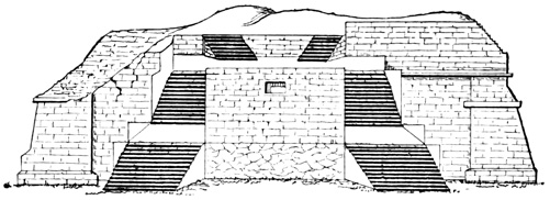
Temple Pyramid—Cerro de las Juntas.
Besides the terrace walls, foundations of dwellings, and the remains that have been mentioned, there are also many ruins of statelier edifices, presumably palaces and temples. Of these, the only ones described are situated at the summit on a small level plateau, of a hundred and twenty-two by two hundred and forty-eight feet. These consist of what are spoken of as a palace and a temple, facing each other, a hundred and sixty-six feet apart. Between the two are the bases of what was formerly a line of circular pillars, leading from one edifice to the other. The bases, or pedestals, are fourteen inches in diameter, five inches high, and about fourteen feet apart. The Temple faces north-east, and its front is shown in the accompanying cut. This is a form of the pyramidal structure very different from any that has been met before. Its dimensions on the ground are fifty by fifty-five feet. The Palace is described as thirty-nine feet high in front and thirty-three feet in the rear, and has a stairway of twenty steps about twenty-eight feet wide, leading up to the summit on the front. Judging by the plate, this so-called palace is a solid elevation with perpendicular sides, ornamented with three plain cornices, one end of which is occupied throughout nearly its whole width by the stairway mentioned. The material of the two structures is the stone of the hill itself cut in thin regular blocks, laid in what is described as mud, and covered, as is shown by traces still left in a few parts, with a coating of plaster. Both the structures, according to the plates, have a rather modern appearance, and differ widely from any other American monuments, but there seems to be no reason to doubt the reliability of Sr Lovato's account, considering its official nature, and I cannot suppose that the Spaniards ever erected such edifices. The foundations and arches of three small apartments are vaguely spoken of as having been discovered by excavation in connection with the Palace, but whether they were on its summit or in the interior of the apparently solid mass, does not clearly appear, although Müller states that the latter was the case. On the summit of the Palace a copal-tree, one foot in diameter, was found. Five sculptured slabs were sketched by Müller at Quiotepec, but he does not state in what part of the ruins they were found. Each slab has a human figure in profile, surrounded by a variety of inexplicable attributes. The foreheads seem to be flattened, and four of the five have an immense curved tongue, possibly the well-known Aztec symbol of speech, protruding from the mouth. Somewhere in this vicinity, on the perpendicular banks of rock that form the channel of the Rio Tecomava, painted figures of a sun, moon, and hand, are reported, at a great height from the water.[VII-69]
TUXTEPEC AND HUAHUAPAN.
Near the town of Tuxtepec, some fifty miles eastward from Quiotepec, near the Vera Cruz boundary, there is said to be an artificial mound eighty-three feet high, known as the Castillo de Montezuma. A passage leads toward the centre, but nothing further is known of it, except that some stone idols are mentioned by another writer as having been dug from a mound in a town of the same name.[VII-70]
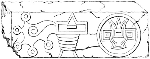
Sculptured Block from Huahuapan.
At Huahuapan, about fifty miles westward of Quiotepec, Dupaix found the sculptured block shown in the cut. It is four and a half feet long, and a foot and a half high; the material is a hard blue stone, and the sculpture in low relief seems to represent a kind of coat of arms, from which projects a hand grasping an object, a part of which bears a strong resemblance to the Aztec symbol of water. This relic was found in a hill called Tallesto, about a league east of the town.[VII-71]
In another hill, called Sombrerito, only half a league from the town, a laborer in 1831 plowed up an ancient grave, said to have contained human bones, fine pottery, with gold beads and rings. All the relics were buried again by the finder, except four of the rings, which came into the possession of the Bishop of Puebla, and two of which are shown in the cut. With some doubts respecting the authenticity of these relics I give the cuts for what they are worth. There are accounts and drawings of several rudely carved stone images from the same region.[VII-72]
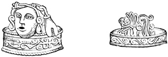
Gold Rings from Huahuapan.
At Yanguitlan, ten or fifteen miles south-east of Huahuapan, several relics were found, including a human head of natural size carved from red stone; two idols of green jasper, slightly carved in human likeness; three cutting implements of hard stone; and the two objects shown in the cuts on the opposite page. The first is a spear-head of gray flint, and the second a very curious relic of unknown use, and whose material and dimensions the finder has neglected to mention. It is of a red color, and is very beautifully wrought in two pieces, one serving as a cover for the other, apparently intended to be joined by a cord as represented in the cut. Among the uses suggested are those of a censer and a lantern.[VII-73]
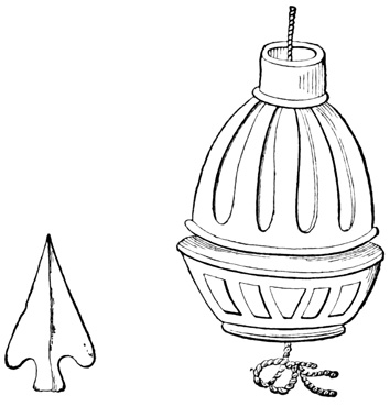
Relics from Yanguitlan.
ANTIQUITIES OF GUERRERO.
Respecting the relics of the state of Guerrero, my only information is derived from a statistical work by Sr Celso Muñoz, contained in the report of Gov. Francisco O. Arce to the legislature of the state in 1872. This author mentions such relics in the district of Hidalgo, north of the Rio Zacatula towards the Mexican boundary, as follows: 1st. "The momoxtles, or tombs of the ancient Indians, which are found in almost all the towns, although they are constantly disappearing, and abound especially in the municipality of Cocula." 2d. "Traces of ancient settlements of the aborigines, who either became extinct or migrated to other localities: such are seen on the hill of Huizteco, in the municipality of Tasco, in that of Tetipac el Viejo and of Coatlan el Viejo, of Tetipac, of Coculatepil, of Piedra Grande or San Gaspar, region of Iglesia Vieja, Cocula, and many others." 3d. At Tepecoacuilco "there are traces very clearly defined of many foundations of houses; and in excavations that have been made there have been found many idols and flint weapons, especially lances, very well preserved, and other curious relics of Aztec times." 4th. At Chontalcuatlan, there are traces of the ancient town on a hill called Coatlan el Viejo, where there is also said to be a block of porphyry one or two mètres in diameter, on the surface of which is sculptured a coiled serpent.[VII-74]