Volume 4 — CHAPTER XII. ANTIQUITIES OF THE NORTHWEST.
Reading edition
General Character of North-western Remains—No Traces of Extinct or of Civilized Races—Antiquities of California—Stone Implements—Newspaper Reports—Taylor's Work—Colorado Desert—Trail and Rock-Inscriptions—Burial Relics of Southern California—Bones of Giants—Mounds in the Saticoy Valley—New Almaden Mine—Pre-Historic Relics in the Mining Shafts—Stone Implements, Human Bones, and Remains of Extinct Animal Species—Voy's Work—San Joaquin Relics—Merced Mounds—Martinez—Shell Mounds round San Francisco Bay, and their Contents—Relics from a San Francisco Mound—Antiquities of Nevada—Utah—Mounds of Salt Lake Valley—Colorado—Remains at Golden City—Extensive Ruins in Southern Colorado and Utah—Jackson's Expedition—Mancos and St Elmo Cañons—Idaho and Montana—Oregon—Washington—Mounds on Bute Prairie—Yakima Earth-work—British Columbia—Deans' Explorations—Mounds and Earth-works of Vancouver Island—Alaska.
Ruins of the New Mexican Pueblo type, described in the preceding chapter, extend across the boundary lines of New Mexico and Arizona, and have been found by travelers in southern Utah and Colorado; stone and bone implements similar to those used by the natives when the first Europeans came and since that time, are frequently picked up on the surface or taken from aboriginal graves in most parts of the whole northern region; a few scattered rock-inscriptions are reported in several of the states; burial mounds and other small earth-heaps of unknown use are seen in many localities; shell mounds, some of them of great size, occur at various points in the coast region, as about San Francisco Bay and on Vancouver Island, and they probably might be found along nearly the whole coast line; and the mining shafts of California have brought to light human remains, implements wrought by human hands, and bones of extinct animals, at great depths below the surface, evidently of great age. With the preceding paragraph and a short account of the ruins of Colorado, I might consistently dispose of the antiquities of the Northwest.
There has not been found and reported on good authority a single monument or relic which is sufficient to prove that the country was ever inhabited by any people whose claims to be regarded as civilized were superior to those of the tribes found by Europeans within its limits. It is true that some implements may not exactly agree with those of the tribes now occupying the same particular locality, and some graves indicate slight differences in the manner of burial, but this could hardly be otherwise in a country inhabited by so many nations whose boundaries were constantly changing. Yet I have often heard the Aztec relics of California and Oregon very confidently spoken of. It is a remarkable fact that to most men who find a piece of stone bearing marks of having been formed by human hands, the very first idea suggested is that it represents an extinct race, while the last conclusion arrived at is that the relic may be the work of a tribe still living in the vicinity where it was found.
CALIFORNIAN RELICS.
California has within her limits large quantities of native utensils and many burial deposits, some of which doubtless date back to the time when no European had yet set foot in the country. A complete description of such relics, illustrated with cuts of typical specimens from different sections of the state, would be of great value in connection with the account of the Californian tribes given in a preceding volume; but unfortunately the material for such description and cuts are utterly wanting, and will not be supplied for many years. Officers and assistants connected with the U. S. Coast Survey and other government exploring expeditions, are constantly, though slowly, gathering relics for the national collection, and a few individuals acting in an unofficial capacity have examined certain localities and described the aboriginal implements found therein through trustworthy mediums. But most of the discoveries in this direction are recorded only in newspaper accounts, which, in a large majority of cases, offer no guarantee of their authenticity or accuracy. Many are self-evident hoaxes; many others are doubtless as reliable as if published in the narrative of the most trust-worthy explorer or in the transactions of any learned society; but to decide upon the relative merits of the great bulk of these accounts is altogether impossible, to say nothing of the absence of drawings, which, after all, are the only satisfactory description of miscellaneous relics. I therefore deem it not advisable to fill the pages of a long chapter with a compilation of the almost innumerable newspaper items in my possession, useless for the most part to antiquarians, and comparatively without interest to the general reader. Dr Alex. S. Taylor has already made quite a complete compilation of the earlier accounts in Californian newspapers, which he published in the California Farmer in 1860-3. Without, as a rule, going into details, I shall present a brief résumé of what has been written about Californian relics of aboriginal times, giving in full only a few reports of undoubted authenticity.[XII-1]
Brasseur de Bourbourg tells us that in the distant north "was found anciently a city named Tula, the ruins of which are thought to have been found in the valley, still so little explored, of Tulares. The Americans have announced in their newspapers the discovery of these Californian ruins, but can one credit the reports?" Brasseur possibly alludes in the paragraph quoted to certain reports circulated about 1853, which announced the discovery, somewhere in the desert of the Colorado on the California side, of a ruined bridge of stone, where no river had run for ages, together with an immense pyramid, and other grand remains. These reports seem to have originated in the correspondence of a Placerville newspaper; but whether they were manufactured in the office of the paper, or were actually sent in by some roaming prospector of an inventive turn of mind, does not appear.[XII-2]
COLORADO DESERT.
Mr Blake found in the Colorado desert "several long, path-like discolorations of the surface, extending for miles in nearly straight lines, which were Indian trails. The only change which was produced appeared to be the removal or dimming of the polish on the pebbles. There was no break in the hard surface, and no dust. That the distinctness of the trail was made by the removing of the polish only, became evident from the fact that figures and Indian hieroglyphics were traced, or imprinted, on the surface adjoining the path, apparently by pounding or bruising the surface layer of the pebbles. These trails seemed very old, and may have endured for many generations."[XII-3] A writer in the Bulletin mentions a road which extends from the mouth of the Coahuila Valley of San Gorgonio Pass, beginning at Noble's ranch, eastwardly across the desert in almost a straight line, to the mouth of the Colorado Cañon. The earth is worn deep, and along its course the surface is strewn with broken pottery. In many of the soft rocks the imprints of the feet of men and animals are still plainly visible. The road is not much over a foot wide, and from it branch off side paths leading to springs or other sources of water.[XII-4] The only other remains in the desert of which I find any record are some rock-inscriptions at Pah Ute Creek, located about thirty miles west from the Mojave villages. Mr Whipple gives a drawing of the inscriptions, which bear a strong resemblance in their general character, as might be expected, to those which have been found in so many localities in the New Mexican region.[XII-5]
The vertical face of a granite cliff at San Francisquito Pass, near a spring, was covered with carved characters, probably similar to those last described. One of the characters resembled a long chain, with a ball at one end, surrounded by rays like those employed in our representations of the sun; another was like in form to an anchor. Well-worn ancient foot-paths, old reservoirs, and other undescribed relics are reported in the vicinity of Owen's lake and river.[XII-6] Painted figures in blue, red, and white, are reported, together with some Spanish inscriptions of a date preceding 1820, in Painted Rock Valley, four days' journey east by south from Tejon Pass, also in the cañada of the San Juan arroyo, which empties into the Salinas River near the mission of San Miguel. In the former case the figures are painted on a blue grayish rock, about twenty feet square and hollowed out in bowl shape.[XII-7]
BURIAL RELICS IN THE SOUTH.
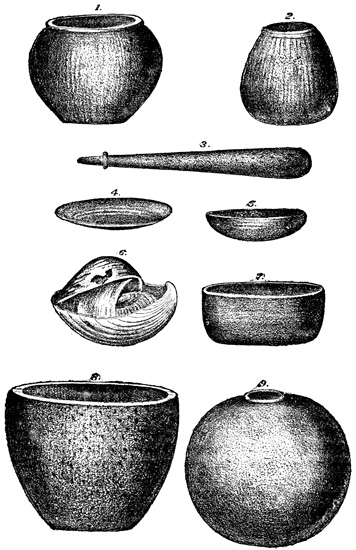
Relics from Southern California.
Mr Paul Schumacher, engaged in the service of the United States Coast Survey, has taken great interest in Californian aboriginal relics, which he has collected for the Smithsonian Institution at Washington. In the vicinity of San Luis Obispo, between points Sal and San Luis, he examined during the past year four graves or burial deposits, known as nipomo, walckhe, kesmali, temeteti. These graves furnished some three hundred human skeletons, or rather about that number were examined, and also quite a large number of domestic utensils, weapons, and ornaments. Among these relics great uniformity is observed, indicating that all the graves belonged to the same tribe of natives. Nine specimens are shown in the cut on the opposite page, made from Mr Schumacher's drawings. Fig. 1, 2, and 9, represent large cooking-pots, globular or pear-shaped, and hollowed out of magnesian mica. The circular opening of fig. 9, having a small and narrow rim, measures only five inches in diameter, while the greatest diameter of the pot is eighteen inches. Near the edge of the opening this vessel is only a quarter of an inch thick, but the thickness increases regularly towards the bottom, where it is an inch and a quarter. Sandstone mortars of different dimensions, but of similar forms, were found in great abundance with the other utensils, one of the largest of which is shown in fig. 8. This is sixteen inches in diameter and thirteen in height. The smallest are only an inch and a half high, and three inches in diameter. The pestles are of the same material, and their form is shown in fig. 3. There was moreover, quite an assortment of what seem to be cups, measuring from one and a quarter to six inches in diameter, and neatly worked out of serpentine, the surface of which was brightly polished. Specimens are shown in fig. 5 and 7. Another similar one, the smallest found, was enclosed in three shells, in a very curious manner, as shown in fig. 6. In this enclosed cup was a quantity of what is described as paint; and traces of the same material were found in all the cups, indicating that they were not used to contain food. Fig. 4 represents a plate which is presumably of stone, although the cut would seem to indicate a shell. These domestic implements deposited by the aborigines with their dead were rarely broken, and when they were so, the breakage was caused in every instance by the pressure of the soil or other superimposed objects. One peculiar circumstance in connection with these relics was that some broken mortars and pestles were repaired by the use of asphaltum as a cement. All the relics collected by Mr Schumacher, as well as those which I have copied, are preserved in the National Museum at Washington.[XII-8] The same explorer is now engaged in making an examination of the islands of the Santa Barbara Channel, where it is not improbable that many interesting relics may be discovered. Mr Taylor heard from a resident of San Buenaventura that "in a recent stay on Santa Rosa Island, in 1861, he often met with the entire skeletons of Indians in the caves. The signs of their rancherías were very frequent, and the remains of metates, mortars, earthen pots, and other utensils very common. The metates were of a dark stone, and made somewhat after the pattern of the Mexican. Extensive caves were often met with which seemed to serve as burial places of the Indians, as entire skeletons and numerous skulls were plentifully scattered about in their recesses." Some very wonderful skulls are also reported as having been found on the islands, furnished with double teeth all the way round the jaw.[XII-9]
MISCELLANEOUS REMAINS.
Miscellaneous relics reported on authority varying from indifferent to bad at different points in the southern part of the state, are as follows: In 1819 an old lady saw a gigantic skeleton dug up by soldiers at Purísima on the Lompock rancho. The natives deemed it a god, and it was re-buried by direction of the padre. Taheechaypah pass and the mission of San Buenaventura are other localities where skeletons of extraordinary size have been found. The old natives at San Luis Rey have seen in the mountain passes tracks of men and animals in solid rock. These tracks were made, those of the men at least, by their fathers fleeing from some convulsion of nature which occurred not many generations back. Nine miles north of Santa Barbara on the Dos Pueblos rancho, some small mounds only two or three feet high have been seen on the point of the mesa overlooking the sea. Mr Carvalho claims to have dug from a small mound near Los Angeles the bones of a mastodon, including four perfect teeth, one of which weighed six pounds. Miss Saxon speaks of high mounds in the vicinity of rivers, said to have been once the site of villages so located for protection against floods.[XII-10]
In the plain at the mouth of the Saticoy River, twelve miles below San Buenaventura, and five or six miles from the sea, are reported two mounds, regular, rounded, and bare of trees. One of them is over a mile long and two hundred feet high, and the other about half as large. If the report of their existence is correct, there seems to be no evidence that they are of artificial formation, except their isolated position on the plain, and a native tradition that they are burial-places. One writer suggests that they are the graves of a people, or of their kings, whose cities are buried beneath the waters of the Santa Barbara Channel. The site of the cities presents some obstacles to exploration, and the details of their construction are not fully known. Twenty miles farther up the Saticoy is a group of small mounds, ten or twelve in number and five or six feet high. They "seem to have been water-worn or worked out by running water all around the mounds so as to isolate each one." Near these mounds, on the Cayetano rancho, is a field of some five hundred acres, divided by parallel ridges of earth, and having distinct traces of irrigating ditches, supplied by a canal which extends two or three miles up the Sespe arroyo. It is said that the present inhabitants of this region, both native and Spanish, have no knowledge of the origin of these agricultural works.[XII-11]
It is said that the New Almaden quicksilver mines were worked by the natives for the purpose of obtaining vermilion, long before the coming of the Spaniards. The excavation made by the aboriginal miners was long supposed to be a natural cavern, extending about one hundred feet horizontally into the hill, until some skeletons, rude mining tools, and other relics of human presence revealed the secret.[XII-12]
In various localities about Monterey, in addition to the usual mortars and arrow-heads, holes in the living rock, used probably as mortars for pounding acorns and seeds, are reported by Taylor; and the Santa Cruz 'skull cave' is spoken of as 'noted throughout the country' for having furnished bones now preserved in the Smithsonian Institution.[XII-13]
REMAINS FROM THE MINES.
One of the most interesting classes of Californian antiquities is that which includes aboriginal remains discovered in the mining counties, at considerable depths below the surface of the ground. The stone implements thus found are not in themselves particularly interesting, or different from those which have been found under other circumstances; nor do they include any specimens which indicate the former existence of any race more advanced than that found in the country by Europeans. But the chief importance of these antiquities consists in the great depth at which some of them have been found, and in the fact that they have been found in connection with the fossil bones of animals belonging to species now no longer existing in the country. The existence of the work of human hands buried hundreds of feet beneath the many successive layers of different rocks and earths, might not necessarily imply a greater age than one dating a few centuries before the coming of the Spaniards; although few would be willing to admit, probably, that natural convulsions so extensive have taken place at so recent an epoch. But when the work of human hands is shown to have been discovered in connection with the bones of mastodons, elephants, horses, camels, and other animals long since extinct, and that they have been so found there seems to be sufficient proof, it is hardly possible with consistency to deny that these implements date from a remote antiquity. Newspaper items describing relics of this class are almost numberless; a few of the specimens have fallen into the hands of scientific men, who have carefully examined and described them; but a great majority, even of such implements as have not been completely overlooked by the miner who dug or washed them from their deep resting-places, have been lost after exciting a momentary curiosity, and their important testimony lost to science. Mr C. D. Voy of Oakland has shown much energy and interest in the examination of stone implements and fossils from the mines. The relics themselves have of course been found in almost every instance by miners in their search for gold; but Mr Voy has personally visited most of the localities where such discoveries were reported, and seems to have taken all possible pains to verify the authenticity of the discoveries, having in many cases obtained sworn statements from the parties who made them. An unpublished manuscript written by this gentleman is entitled Relics of the Stone Age in California, and is illustrated with many photographs of specimens from his own and other collections. This work, kindly furnished me by Mr Voy, is probably the most complete extant on the subject, and from it I take the following descriptions. The author proceeds by counties, first describing the geology of each county, and then the relics of whose existence he has been able to learn, and the localities where they were found. Except a brief statement in a few cases of the depth at which stone remains were found, and of the strata that covered them, I shall not touch upon the geologic formation of the mining region. Nor does a particular or scientific description of the fossil remains come within the scope of my work. A brief account of the stone implements and the positions in which they have been discovered will suffice.
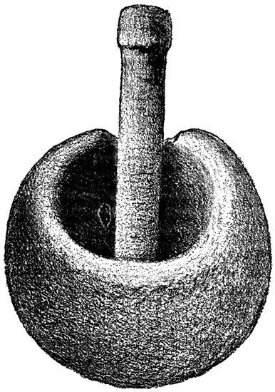
Stone Mortar—Kincaid Flat.
TUOLUMNE COUNTY.
Of all the counties Tuolumne has apparently proved the richest in antiquarian remains. From the mining tunnels which penetrate Table Mountain there was taken in 1858 a stone mortar holding two quarts, at a depth of three hundred feet from the surface, lying in auriferous gravel under a thick strata of lava. In 1862 another mortar was found at a depth of three hundred and forty feet, one hundred and four of which were composed of lava, and eighteen hundred feet from the mouth of the tunnel. This relic is in Mr Voy's collection, accompanied by a sworn statement of the circumstances of its finding. Dr Snell is said to have had in his possession in 1862 a pendant or shuttle of silicious slate, similar to others of which I shall give a cut; spear-heads six or eight inches long, and broken off at the hole where they were attached to the shaft; and a scoop, or ladle, of steatite. These relics were found under Table Mountain at the same depth as the preceding, together with fossil bones of the mastodon and other animals, and are preserved in the Smithsonian Institute and in the museum of Yale College. The cut represents a stone mortar and pestle, found at Kincaid Flat in clayey auriferous gravel, sixteen or twenty feet below the surface, where many other stone implements, with bones of the mastodon, elephant, horse, and camel, have been found at different times. A bow handle, or shuttle, of micaceous slate found here will be shown in another cut with similar relics from a different locality.[XII-14]
At Shaw's Flat, with bones of the mastodon, a stone bead of calc-spar, two inches long and the same in circumference, was taken from under a strata of lava at a point three hundred feet from the mouth of the tunnel. The granite mortar shown in the cut, holding about a pint, came from the same mining town.
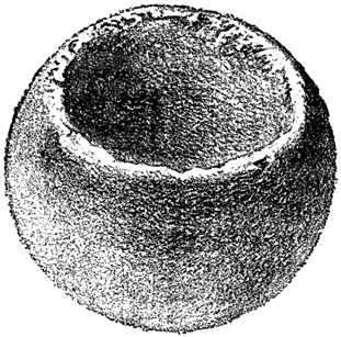
Granite Mortar—Shaw's Flat.
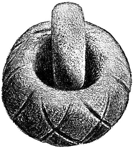
Granite Mortar—Gold Springs Gulch.
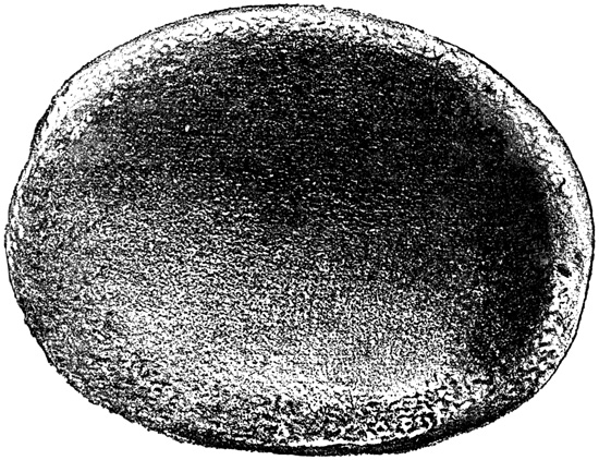
Granite Dish—Gold Springs Gulch.
At Blanket Creek, near Sonora, stone relics and bones of the mastodon were found together in 1855.[XII-15] Wood's Creek was another locality where stone relics with fossil bones, including those of the tapir, are reported to have been dug out at a depth of twenty to forty feet. The mortar and pestle shown in the cut is one of many stone implements found, with fossil bones, at Gold Springs Gulch, in 1863, at a depth of sixteen feet in auriferous gravel, like the most of such relics. It is twelve and a half inches in diameter, weighs thirty pounds, and holds about two quarts. The cross-lines pecked in on the sides with some sharp instrument, are of rare occurrence if not unique. Among the other implements found here, are what Mr Voy describes as "discoidal stones, or perhaps spinal whorls. They are from three to four inches in diameter, and about an inch and a half thick, both sides being concave, with centre perforated. It has been suggested that these stones were used in certain hurling games." They are of granite and hard sandstone. The author has heard of similar relics in Ohio, Denmark, and Chili. Another relic, found at the same place in 1862, with the usual bones under twenty to thirty feet of calcareous tufa, is a flat oval dish of granite, eighteen inches and a half in diameter, two or three inches thick, and weighing forty pounds. It is shown in the cut, and, like the preceding, is preserved in Mr Voy's cabinet, now at the University of California. Texas Flat was another locality where fossil bones were found with fresh-water shells.[XII-16]
CALAVERAS COUNTY.
Calaveras County has also yielded many interesting relics of a past age, of the same nature as those described in Tuolumne.[XII-17] The famous 'Calaveras skull' was taken from a mining shaft at Altaville, at a depth of one hundred and thirty feet beneath seven strata of lava and gravel.[XII-18] The evidence was sufficient to convince Prof. Whitney and other scientific men that this skull was actually found as claimed, although on the other hand some doubt and not a little ridicule have been expressed about the subject. Many stone mortars and mastodon-bones have been found about Altaville and Murphy's, but not under lava.[XII-19]
At San Andrés, in 1864, according to sworn statements in Mr Voy's possession, large stone mortars were taken from a layer of cemented gravel six feet thick, lying under the following strata:—coarse sedimentary volcanic material, five feet; sand and gravel, one hundred feet; brownish volcanic ash, three feet; cemented sand, four feet; blueish volcanic sand, fifteen feet. At the Chili Gulch, near Mokelumne Hill, the skull of a rhinoceros is reported to have been found in 1863.[XII-20]
STONE HAMMERS.
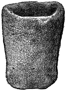
Mortar from Shingle Springs.
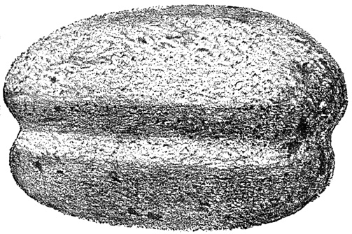
Stone Hammer—Spanish Flat.
The mortar shown in the cut was found in gravel at a depth of ten feet, at Shingle Springs in El Dorado County. At Georgetown and vicinity there were found at different dates, large stone dishes very similar to that at Gold Springs Gulch, shown in a preceding cut; grooved stones like those at Spanish Flat, soon to be mentioned; and mortars resembling that at Kincaid Flat. At Spanish Flat were found several oval stones with grooves round their circumference, as shown in the preceding cut, and weighing from a pound and a half to two pounds. They were apparently used as hammers or weapons by fitting a withe handle round them at the groove. Many other mortars and stone implements were taken from the same locality, including two pendants, shuttles, or bow-handles, very well worked from greenstone, five or six inches long, and about one inch thick in the middle. These two relics, together with a similar one from Table Mountain before alluded to, are shown in the cut. At Diamond Spring mortars were found at a depth of a hundred feet, and both fossil bones and stone relics have been taken from time to time from the mines about Placerville.[XII-21]
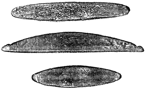
Stone Implements—Spanish Flat.
In Placer County, mastodon bones are reported at Rockland, and stone mortars and other implements at Gold Hill and Forest Hill. One dish at the latter place was much like that at Gold Springs Gulch, shown in a preceding cut.[XII-22]
In Nevada County stone implements have been found at different dates, from ten to eighty feet below the surface, at Grass Valley, Buckeye Hill, Myer's Ravine, Brush Creek, and Sweetland.[XII-23]
Fossil bones of extinct animals and stone implements like those that have been described, and which I do not deem it necessary to mention particularly, since such mention would be but a repetition of what has been said, with a list of depths and localities, have been found, according to Mr Voy's explorations, in Butte County at New York Flat, Oroville, Bidwell's Bar, and Cherokee Flat; in Stanislaus about Knights Ferry; in Amador at Volcano, Little Grass Valley, Jackson, Pokerville, Forest Home, and Fiddletown; in Siskiyou at Trench Bar, on Scott River, at Yreka, and Cottonwood; in Trinity about Douglas City; in Humboldt, at Ferndale and Humboldt Point; in Merced at Snelling on Dry Creek; in Mariposa, at Horse Shoe Bend, Hornitos, Princetown,—a mortar thirty-six inches in diameter—Buckeye Ravine, Indian Gulch, and Bear Creek; in Fresno at Buchanan Hollow and Millerton; and at several points not specified in Tulare and Fresno.[XII-24]
Relic from San Joaquin Valley.
MISCELLANEOUS MINE RELICS.
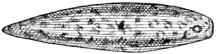
The cut shows a stone relic discovered in digging a well in the San Joaquin Valley, imbedded in the gravel thirty feet below the surface. "The material is sienite and the instrument is ground and polished so as to display in marked contrast the pure white of the feldspar and the dark-green or black of the hornblende. It is in the form of a double-cone, one end terminating in a point, while the other end is blunted, where it is pierced with a hole which instead of being a uniform gauge, is rimmed out, the rimming having been started from the opposite sides. In examining this beautiful relic, one is led almost instinctively to believe that it was used as a plummet for the purpose of determining the perpendicular to the horizon. So highly-wrought a stone would hardly have been used as a sinker for a fishing-net: it may have been suspended from the neck as a personal ornament. When we consider its symmetry of form, the contrast of colors brought out by the process of grinding and polishing, and the delicate drilling of the hole through a material so liable to fracture, we are free to say it affords an exhibition of the lapidary's skill superior to anything yet furnished by the Stone Age of either continent," at least such is Mr Foster's conclusion. Prof. Whitney states that he has two or three similar implements, and that they are generally regarded as sinkers for use in fishing.[XII-25] Mr Taylor tells us that he saw in 1852, on a high mesa, probably a league in circumference, on or near the Merced River, thousands of small mounds, five or six feet high, and apparently of earth only.[XII-26] Capron says that on the plains of San Joaquin "are found immense mounds of earth, which present evidences of their great antiquity. It is supposed that they were thrown up, by the Indians, for observatories, from which to survey the floods, or as places of resort for safety when the plains became suddenly inundated, and the ranging hunters were caught far in the interior."[XII-27] In the banks of a creek near Martinez, resting on yellow clay, under five feet of surface soil, a mortar and pestle were recently found by some boys, according to a local newspaper. The mortar was about sixty inches in circumference, and weighed nearly two hundred pounds. "It has the form of a slightly flattened well-rounded duck egg; and has evidently been artificially shaped in exterior form, as well as in the bowl, and looks as fresh as if it had but yesterday been turned off from the Indian sculptor's hands, while the polish of the pestle is smooth and lustrous, as if it had been in daily use for the hundred or two years, at least, that it must have been lying under the inverted mortar, as shown by the level of five-feet accumulations of the valley-surface stratum of soil above the yellow clay upon which it was found, together with the partially-decomposed remains of a human frame."[XII-28]
SHELL MOUNDS.
SAN FRANCISCO RELICS.
Relics from a Shell-Mound—San Francisco.
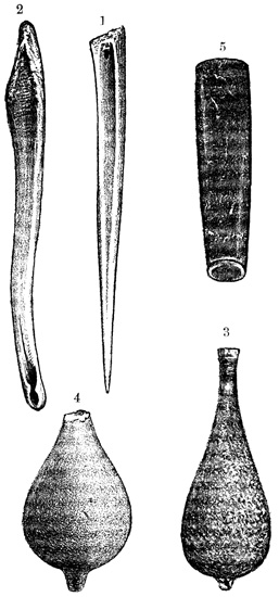
Only one class of Californian antiquities remains to be mentioned—the shell mounds. They are probably very numerous, and a thorough examination of their contents could hardly fail to be here as it has proved in Europe, a source of very important results in connection with ethnological studies. Little or nothing has been done in the way of such an examination, although a few mounds have been opened in excavating for roads or foundations of buildings. These few have yielded numerous stone, bone, and shell implements and ornaments, together with human remains, as is reported, but the relics have been for the most part lost or scattered, and submitted to no scientific examination and comparison. Dr Yates sent to the Smithsonian Institute, in 1869, a collection of relics taken from mounds in Alameda County. It is not expressly stated that these were shell mounds, although I have heard of the existence of several in that county. This collection included, "stone pestles, perforators or awls, sinkers, a phallus, spindles, a soapstone ladle, stone mortar and pestle, pipe bowls, shell and perforated stone ornaments, an ancient awl and serrated implements of bone."[XII-29] A very large shell mound is reported near San Pablo, in Contra Costa County. It is said to be almost a mile long and a half a mile wide, and its surface is covered with shrubbery. The shells composing this mound are those of the oyster, clam, and mussel, all having been exposed to the action of fire, and nearly all broken. Fragments of pottery made of red clay are found on the surface and near the top.[XII-30] Many smaller shell mounds are reported in the vicinity of San Mateo, and one has been opened in making a road at Saucelito during the present year, furnishing many stone relics, of which I have no particular description. Quite a number of mounds are known to exist on the peninsula of San Francisco, several being in the vicinity of the silk factory on the San Bruno road. One of them covered an area of two acres, was at least twenty-five feet deep, and from it were taken arrow-heads, hammers, and many other relics. One of these shell mounds, near the old Bay View race track is being opened by Chinamen engaged in preparation for some building, as I write this chapter. Mr James Deans, of whose explorations I shall have more to say when treating of the antiquities of British Columbia, has brought me a large number of stone and bone relics taken from this deposit, the different classes of which are illustrated in the accompanying cut. Fig. 1 is an awl of deer-bone, and fig. 2 is another implement of the same material, curiously grooved at the end. These bone implements occur by thousands, being from three to eight inches in length. Fig. 3, 4, are perhaps stone sinkers, or as is thought by some, weights used in weaving, symmetrically formed, the former from diorite, the latter from sandstone, and not polished. Fig. 3 is four inches long, and an inch and a half in its greatest diameter. Hundreds of these pear-shaped weights are found in the mounds, but the end is usually broken off, as is the case with fig. 4. Fig. 5 is an implement carved from a black clayey slate, and has a brightly polished surface. It is four inches long, one inch in diameter at the larger end, and three quarters of an inch at the smaller. It is hollow, but the bore diminishes in size regularly from each end, until at a point about an inch and a half from the smaller end it is only a quarter of an inch in diameter. I have no idea what purpose this implement was used for, unless it served as a handle for a small knife or awl, or possibly as a pipe.
Such is the rather fragmentary and unsatisfactory information I am able to present respecting aboriginal relics in California. Doubtless there are many relics, and valuable scraps of information respecting the circumstances of their discovery, in the possession of individuals, of which no mention is made in this chapter—indeed, I expect to hear of a hundred such cases within a month after the appearance of this volume; but many years must necessarily elapse before a satisfactory and comprehensive account of the antiquities of our state can be written, and in the meantime there is a promising field for patient investigation. The difference, after all, between this chapter and many of those that precede it, in respect to thoroughness, is more apparent than real; that is, it results naturally from the nature of north-western remains. For if there were architectural monuments, pyramids, temples, and fortifications, or grand sculptured idols and decorations, in California and her sister states, there is no doubt that such monuments would have been ere this more thoroughly explored than those of Palenque; and on the other hand, respecting the only classes of antiquities found in the Northwest, there yet remains as much or more to learn in Mexico and Central America as in the Pacific United States.
ANTIQUITIES OF NEVADA.
Respecting the antiquities of Nevada, I have only the following account of a ruined city in the south-eastern part of the state, discovered by what is spoken of as the 'Morgan Exploring Expedition,' and described by a correspondent of the New York Tribune. "On October fifteenth, in the centre of a large valley we discovered some Indian salt works, but there were no signs of their having been lately used. In the southern section of the same valley, was a curious collection of rocks, mounds and pillars, covering several acres in extent and resembling the ruins of an ancient city. We saw some remnants of what had once been arches, with keystones still perfect, and a number of small stone pillars constructed with a peculiar kind of red mortar or cement, set upright about twenty feet apart, as if they had been used to support an aqueduct for conveying water from a large stream half a mile distant, into the outskirts of the city. In some places the lines of streets were made distinctly visible by the great regularity of the stones. These streets were now covered with sand many feet deep, and seemed to run at right angles to each other. Some of the stones had evidently been cut into squares with hard tools, although their forms had been nearly destroyed by centuries of time. The impression forced upon our minds was that the place had been once inhabited by human beings somewhat advanced in civilization. Many traders noticed the existence of similar ruins in other sections of the country between the Rocky and Sierra Nevada Mountains. They may probably be the sites of once flourishing fields and habitations of the ancient Aztecs."[XII-31] It is just possible that the New Mexican type of ruins extends across into Nevada as it is known to into Utah and Colorado, and that a group of such remains was the foundation of the report quoted. It is quite as likely, however, that the report is groundless.
SALT LAKE VALLEY.
Mr Rae examined a group of burial mounds in the Salt Lake Valley, Utah, and took from them "flint spear heads, flint arrow-heads, stone implements and fragments of rude pottery." These mounds had the appearance of natural sand-hills, as the people in the vicinity supposed them to be.[XII-32] An article in the Salt Lake Telegraph is the only other authority that I find on these mounds, and this does not specify their locality. "The mounds, as they exist to-day, do not exhibit much uniformity, but this can be accounted for by the disintegrating action of rains and winds, to which they have been so long subject. Immediately north, south and west of the largest barrow, traces can be seen of others now all but obliterated, and the locality bears unmistakable evidences of once being the site of very extensive earthworks. In one mound or barrow only, the largest, were remains found, and they were exposed on or very near the surface of the sandy soil, in one or two large hollows near the centre. The other barrows were destitute, at least on the surface, but what there may be below it is hard to say. Of all the relics, except those of charred bone, which are comparatively plentiful, and some in a state of petrifaction, that of pottery is the most abundant, and to this day some of it retains a very perfect glaze. Much of it, however, is rough, and from the specimens we saw, the art does not appear to have attained to so high a degree of perfection as among the ancient nations that inhabited the Mississippi and Ohio valleys. The largest piece of pottery seen was not above three inches square, and it appeared, as did all the other pieces, to have formed a portion of some rounded vessel, probably a cinerary urn or something of that kind. Other articles were seen, such as a fragment of pearly shell, several other shells, a white cylindrical bead, a small ring probably a bead also, and a stone knife." There were also several nicely shaped arrow-heads, of obsidian, agate, rock-crystal, carnelian, and flint. Granite mills are mentioned in addition to the other relics.[XII-33] The same authority speaks of an extensive fortification or entrenched camp at the head of Coon's Cañon, about twenty miles south-west of Salt Lake City. The works are now from four to eight feet high, and the places of entrance are distinctly marked.
Rock-Inscriptions—Utah.
ROCK-INSCRIPTIONS.
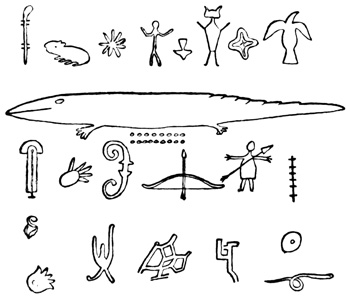
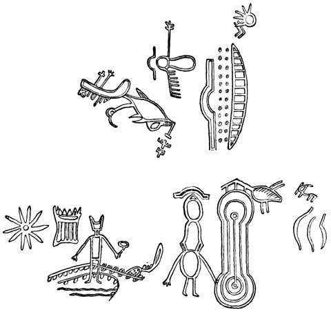
Remy and Brenchley note the finding of colored pottery at Cedar City, indicating "that the Mormon city is built on the site of a considerable city belonging to the Aztecs," for there is no state anywhere in the north where the Aztecs did not live at some time or other. Whole specimens of pottery are not found, but the fragments are said to show a high degree of perfection; the same authors claim that furnaces for the manufacture of pottery are still seen, and further say: "At some miles to the north as well as to the south of Cedar,—to the north near Little Salt Lake, to the south near Harmony,—are to be seen great rocks covered over with glyphic inscriptions, some portions of which, sketched at random, are accurately represented in our engraving. These inscriptions or figures are coarsely executed; but they all represent objects easy of recognition, and for the most part copied from nature."[XII-34] From Carvalho I quote that "on Red Creek cañon, six miles north of Parowan there are very massive, abrupt granite rocks, which rise perpendicularly out of the valley to the height of many hundred feet. On the surface of many of them, apparently engraved with some steel instrument, to the depth of an inch, are numerous hieroglyphics, representing the human hand and foot, horses, dogs, rabbits, birds and also a sort of zodiac. These engravings present the same time-worn appearance as the rest of the rocks; the most elaborately engraved figures were thirty feet from the ground. I had to clamber up the rocks to make a drawing of them. These engravings evidently display prolonged and continued labor, and I judge them to have been executed by a different class of persons than the Indians, who now inhabit these valleys and mountains—ages seem to have passed since they were done. When we take into consideration the compact nature of the blue granite and the depth of the engravings, years must have been spent in their execution. For what purpose were they made? and by whom, and at what period of time? It seems physically impossible that those I have mentioned as being thirty feet from the valley, could have been worked in the present position of the rocks. Some great convulsion of nature may have thrown them up as they now are. Some of the figures are as large as life, many of them about one-fourth size." The same author reports the remains of an adobe town a mile further down the cañon, with implements—remains said to have been found there by the first Mormons that came to the valley.[XII-35] Mr Foster quotes from a Denver paper an item recording the discovery of a mound in southern Utah, which yielded relics displaying great artistic skill;[XII-36] and finally I take from Mr Schoolcraft's work cuts showing inscriptions on a cliff in a locality not clearly specified.[XII-37] Some remains in the south-eastern corner of the state I shall mention in connection with those of Colorado.
Rock-Inscriptions—Utah.
About half a mile west of Golden City, Jefferson County, Colorado, Mr Berthoud reports to the Smithsonian Institution the existence of some ancient remains, at the junction of two ravines. They consist of a central mound of granitic sand not over twelve inches high, with traces of five or six shallow pits about it; all surrounded by traces of a wall consisting of a circle of moss-covered rough stones partially imbedded in the soil. South of the central mound is also a saucer-shaped pit, measuring twelve feet in width and from fifteen to eighteen inches in depth. At this point buffalo-bones and fragments of antlers are plentiful, and pieces of flint with plates of mica have also been discovered.[XII-38] Mr Farnham speaks of a ruined city covering an area of one mile by three fourths of a mile, with streets crossing at right angles, buildings of rough trap rock in cement, a mound in the centre, and much glazed pottery—all this on the north bank of the Colorado, four hundred miles up the river, and as likely to be in the territory of Colorado as anywhere.[XII-39] Mr Foster quotes from a Denver newspaper a report of large granite blocks, of the nature of 'dolmens' standing in an upright position, on the summit of the Snowy Range;[XII-40] and Taylor had heard through the newspapers of pyramids and bridges in this territory.[XII-41]
There remain to be described in this part of the country only the remains of aboriginal structures in the south-western corner of Colorado and the south-eastern corner of Utah, remains which, although made known to the world only through a three or four days' exploration by a party of three men, are of the greatest interest and importance. They are found in the valleys or cañons of the rivers Mancos and McElmo, northern tributaries of the San Juan, on the southern tributaries of which river are the ruins, already described, of the Chaco and Chelly cañons.
JACKSON'S EXPEDITION.
In September, 1874, Mr W. H. Jackson and Mr Ingersoll, connected with the United States Geological and Geographical Survey party, guided by Capt. John Moss, an old resident perfectly familiar with the country and its natives, descended both the cañons referred to, for the express purpose of examining ancient structures reported to exist there. Notwithstanding the brief duration of their exploration, as they understood their business and had a photographic apparatus along, their accounts are extremely complete and satisfactory. Mr Ingersoll published an account of the trip in the New York Tribune of Nov. 3, 1874; and Mr Jackson in the Bulletin of the Survey, printed by government.[XII-42] The latter account was accompanied by fourteen illustrations, and Prof. J. V. Hayden, Geologist in charge of the Survey, has had the kindness to furnish me also with the original photographs made during the expedition.
The Rio Mancos rises in the Sierra La Plata, and flows south-westward, at first through a park-like valley, then cuts a deep cañon through the Mesa Verde, and finally traverses an open plain to join the San Juan. In the valley between the mountains and the mesa, there are abundant shapeless mounds of débris, which on examination are found to represent blocks of square buildings and circular enclosures all of adobe, very similar apparently to what we have seen in the Salado valley of Arizona. There is another resemblance to the southern remains in the shape of indented and painted pottery, strewn in great abundance about every mound, in fragments rarely larger than a dollar,—not a greenback, but a silver dollar, the former being no standard for archæological comparisons. I shall make no further mention of pottery; the reader may understand that in this whole region, as in Arizona and New Mexico, it is found in great quantities about every ruin that is to be mentioned.
RIO DE LOS MANCOS.
The cañon through the Mesa Verde is on an average two hundred yards wide, and from six hundred to a thousand feet deep, with sides presenting, as Mr Jackson says, "a succession of benches, one above the other, and connected by the steep slopes of the talus. Side-cañons penetrate the mesa, and ramify it in every direction, always presenting a perpendicular face, so that it is only at very rare intervals that the top can be reached." Mr Ingersoll says: "Imagine East River a thousand or twelve hundred feet deep, and drained dry, the piers and slips on both sides made of red sandstone, and extending down to that depth, and yourself at the bottom, gazing up for human habitations far above you. In such a picture you would have a tolerable idea of this Cañon of the Rio Mancos." For four or five miles after entering the cañon, the shapeless heaps of adobe débris were of frequent occurrence on the banks of the stream. The general characteristic was "a central mass considerably higher and more massive than the surrounding lines of subdivided squares. Small buildings, not more than eight feet square, were often found standing alone apparently." The high central portion suggests a terraced structure like the Casa Grande of the Gila. One of the buildings on the bottom, measuring eight by ten feet, was of sandstone blocks, about seven by twelve inches, and four inches thick, laid in what seemed to be adobe mortar. Somewhat further down the adobe ruins were found often on projecting benches, or promontories of the cliff, some fifty feet above the stream. Here they were circular, with a depression in the centre, and generally in pairs. Cave-like crevices along the seams were often walled up in front, so as to enclose a space sometimes twelve feet long, but oftener forming "cupboard-like inclosures of about the size of a bushel-basket." A small square, formed by rough stone slabs, set up endways in the earth, was also noticed.
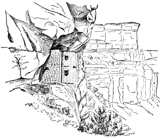
Cliff House—Mancos Cañon.
The first stone building particularly described, and one of the most wonderful found during the trip, is that shown in the cut. The most wonderful thing about it was its position in the face of the cliff several hundred feet above the bottom, on a ledge ten feet wide and twenty feet long, accessible only by hard climbing with fingers and toes inserted in crevices, or during the upper part of the ascent by steps cut in the steep slope by the aborigines. The cliff above overhangs the ledge, leaving a vertical space of fifteen feet. The building occupies only half the length of the ledge, and is now twelve feet high in front, leaving it uncertain whether it originally reached the overhanging cliff, or had an independent roof. The ground plan shows a front room six by nine feet, and two rear rooms each five by seven, projecting on one side so as to form an L. There were two stories, as is shown by the holes in the walls and fragments of floor-timbers. A doorway, twenty by thirty inches and two feet above the floor, led from one side of the front room to the esplanade, and there was also a window about a foot square in the lower story, and a window or doorway in the second story corresponding to that below. Opposite this upper opening was a smaller one opening into a reservoir holding about two hogsheads and a half, and formed by a semicircular wall joining the cliff and the main wall of the house. A line of projecting wooden pegs led from the window down into the cistern. Small doorways afforded communication between the apartments. The front portion was built of square and smoothly faced sandstone blocks of different sizes, up to fifteen inches long and eight inches thick, laid in a hard grayish-white mortar, very compact and hard, but cracked on the surface like adobe mortars. The rear portions were of rough stones in mortar, and the partition walls were like the exterior front ones, and seemed to have been rubbed smooth after they were laid.
The interior of the front rooms was plastered with a coating of a firm cement an eighth of an inch thick, colored red, and having a white band eight inches wide extending round the bottom like a base-board. There were no other signs of decoration. The floor was the natural rock of the ledge, evened up in some places with cement. The lintel of the upper doorway or window was of small straight cedar sticks laid close together, and supporting the masonry above; the other lintels seem to be of stone. A very wonderful feature of this structure was that the front wall rests on the rounded edge of the precipice, sloping at an angle of forty-five degrees, and the esplanade, or platform, at the side of the house was also leveled up by three abutments resting on this slope, where "it would seem that a pound's weight might slide them off."
TOWERS ON THE RIO MANCOS.
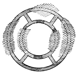
Ground Plan—Mancos Tower.
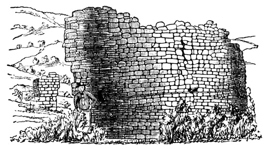
Round Tower—Mancos Cañon.
The cut shows the ground plan of a round stone tower of peculiar form. The diameter is twenty-five feet, and that of the inner circle twelve feet,[XII-43] the walls being eighteen and twelve inches thick, standing in places fifteen feet high on the outside and eight feet on the inside. This tower stands in the centre of a group of faintly traced remains extending twenty rods in every direction. The stones of which it was built are irregular in size, laid in mortar, and chinked with small pieces. The cut presents a view of this tower. The next cut illustrates the small cliff-houses very common in the walls of the cañon. This and its companions are from fifty to a hundred feet above the trail; it is five by fifteen feet and six feet high, the blocks composing the walls being very regular and well laid. Some of these houses were mere walls in front of crevices in the cliff. So strong are the structures that in one place a part of the cliff had become detached by some convulsion, and stood inclined at quite an angle, taking with it a part of one of the walls, but without overthrowing it. Small apertures are so placed in all these cliff-structures as to afford a look-out far up and down the valley. Rude inscriptions are scratched on the cliff in many places, bearing a general resemblance to those farther south, of which I have given many illustrations.
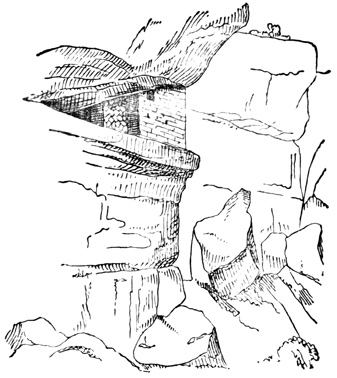
Cliff-Dwelling—Mancos Cañon.
One of the most inaccessible of the cliff-buildings is shown in the cut. It is eight hundred feet high, and can only be reached by climbing to the top of the mesa, and creeping on hands and knees down a ledge only twenty inches wide. The masonry was very perfect, the blocks sixteen by three inches, ground perfectly smooth on the inside so as to require no plaster. The dimensions were about five by fifteen feet, and seven feet high. The aperture serving as doorway and window was twenty by thirty inches and had a stone lintel. Near by but higher on the ledge was another ruder building. These raised structures were invariably on the western side of the cañon, but those on the bottom were scattered on both sides of the river.
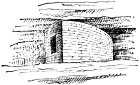
Cliff-Dwelling—Mancos Cañon.
On the bottom "the majority of the buildings were square, but many round, and one sort of ruin always showed two square buildings with very deep cellars under them and a round tower between them, seemingly for watch and defence. In several cases a large part of this tower was still standing." One of these typical structures is shown in the following cut. It is twelve feet in diameter, twenty feet high, with walls sixteen inches thick. The window facing northward is eighteen by twenty-four inches. The two apartments adjoining the tower, the remains of which are shown in the cut, are about fifteen feet square. They seem to have been originally underground structures, or at least partially so.
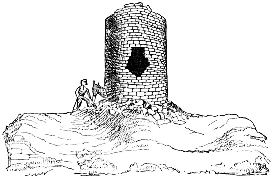
Watch-Tower—Mancos Cañon.
At the outlet of the cañon the river turns westward, flowing for a time nearly parallel with the San Juan, which it joins very nearly at the corner of the four territories. Many groups of walls and heaps were visible in the distance down the valley, but the explorers left the river at this point and bore away to the right along the foot of the mesa until they reached Aztec Spring, very near the boundary line. "Immediately adjoining the spring, on the right, as we face it from below, is the ruin of a great massive structure of some kind, about one hundred feet square in exterior dimensions; a portion only of the wall upon the northern face remaining in its original position. The débris of the ruin now forms a great mound of crumbling rock, from twelve to twenty feet in height, overgrown with artimisia, but showing clearly, however, its rectangular structure, adjusted approximately to the four points of the compass. Inside this square was a circle, about sixty feet in diameter, deeply depressed in the centre, and walled. The space between the square and the circle appeared, upon a hasty examination, to have been filled in solidly with a sort of rubble-masonry. Cross-walls were noticed in two places; but whether they were to strengthen the walls or had divided apartments could only be conjectured. That portion of the outer wall remaining standing was some forty feet in length and fifteen in height. The stones were dressed to a uniform size and finish. Upon the same level as this ruin, and extending back, I should think, half a mile, were grouped line after line of foundations and mounds, the great mass of which was of stone, but not one remaining upon another. All the subdivisions were plainly marked, so that one might, with a little care, count every room or building in the settlement. Below the above group, some two hundred yards distant, and communicating by indistinct lines of débris, was another great wall, inclosing a space of about two hundred feet square. Only a small portion was well enough preserved to enable us to judge, with any accuracy, as to its character and dimensions; the greater portion consisting of large ridges flattened down so much as to measure some thirty or more feet across the base, and five or six feet in height. This better preserved portion was some fifty feet in length, seven or eight feet in height, and twenty feet thick, the two exterior surfaces of well-dressed and evenly-laid courses, and the centre packed in solidly with rubble-masonry, looking entirely different from those rooms which had been filled with débris, though it is difficult to assign any reason for its being so massively constructed. It was only a portion of a system extending half a mile out into the plains, of much less importance, however, and now only indistinguishable mounds. The town built about this spring was nearly a square mile in extent, the larger and more enduring buildings in the centre, while all about were scattered and grouped the remnants of smaller structures, comprising the suburbs."
CAÑON OF THE McELMO.
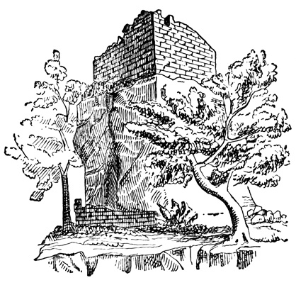
Tower on the McElmo, Colorado.
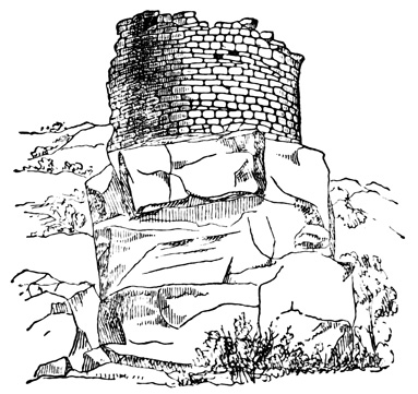
Round Tower on the McElmo.
Four miles from the spring is the McElmo, a small stream, dry during a greater part of the year. At the point where the party struck this stream, portions of walls, and heaps of débris in rectangular order were scattered in every direction; among which two round towers were noticed, one of them with double walls, like that on the Mancos, but larger, being fifty feet in diameter. Following down the McElmo cañon aboriginal vestiges continue abundant, including cliff-dwellings like those that have been described, but only forty or fifty feet above the valley, and also the square tower shown in first cut. It stands on a square detached block of sandstone forty feet in height. The walls of this building were still fifteen feet high in some places, and there were also traces of walls about the base of the rock. Another double-walled round tower fifty feet in diameter found near the one last named is shown in the second cut.
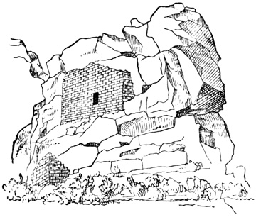
Building on the McElmo—Utah.
RUINS ON THE McELMO.
Still further down the cañon, across the boundary line into Utah, ruins continue abundant. A red sandstone butte standing in the middle of the valley, one hundred feet high and three hundred long, has traces of masonry on its summit, apparently intended to form a level platform, and on one side, at mid-height, the structures shown in the cut. The upper wall is eighteen feet long and twelve feet high, and the blocks composing it are described as more regularly cut than any before seen. The only access to the summit of the butte was by climbing through the window of the building. Other remains, including many circular depressions of considerable depth, and a square tower with one round corner, are scattered about near the base of this butte, or cristone. The next cut shows one of the cave-dwellings near by, formed by walling up the front of a recess in the cliff.
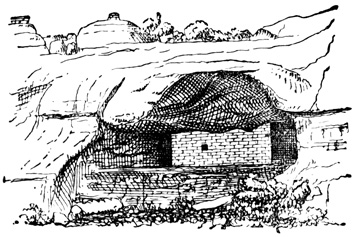
Cave-Dwelling on the McElmo.
ABORIGINAL TRADITION
The tradition relating to the whole, and particularly to this locality, obtained by Capt. Moss from one of the old men among the Moquis, is rendered by Mr Ingersoll as follows:—"Formerly the aborigines inhabited all this country we had been over as far west as the head waters of the San Juan, as far north as the Rio Dolores, west some distance into Utah, and south and south-west throughout Arizona, and on down into Mexico. They had lived there from time immemorial—since the earth was a small island, which augmented as its inhabitants multiplied. They cultivated the valley, fashioned whatever utensils and tools they needed, very neatly and handsomely out of clay and wood and stone, not knowing any of the useful metals, built their homes and kept their flocks and herds in the fertile river bottoms, and worshiped the sun. They were an eminently peaceful and prosperous people, living by agriculture rather than by the chase. About a thousand years ago, however, they were visited by savage strangers from the North, whom they treated hospitably. Soon these visits became more frequent and annoying. Then their troublesome neighbors—ancestors of the present Utes—began to forage upon them, and at last to massacre them and devastate their farms; so, to save their lives at least, they built houses high upon the cliffs, where they could store food and hide away till the raiders left. But one Summer the invaders did not go back to their mountains as the people expected, but brought their families with them and settled down. So driven from their homes and lands, starving in their little niches on the high cliffs, they could only steal away during the night, and wander across the cheerless uplands. To one who has traveled these steppes, such a flight seems terrible, and the mind hesitates to picture the suffering of the sad fugitives.
"At the christone they halted and probably found friends, for the rocks and caves are full of the nests of these human wrens and swallows. Here they collected, erected stone fortifications and watch-towers, dug reservoirs in the rocks to hold a supply of water, which in all cases is precarious in this latitude, and once more stood at bay. Their foes came, and for one long month fought and were beaten back, and returned day after day to the attack as merciless and inevitable as the tide. Meanwhile the families of the defenders were evacuating and moving south, and bravely did their protectors shield them till they were all safely a hundred miles away. The besiegers were beaten back and went away. But the narrative tells us that the hollows of the rocks were filled to the brim with the mingled blood of conquerors and conquered, and red veins of it ran down into the cañon. It was such a victory as they could not afford to gain again, and they were glad when the long fight was over to follow their wives and little ones to the South. There in the deserts of Arizona, on well-nigh unapproachable isolated bluffs, they built new towns, and their few descendants—the Moquis—live in them to this day, preserving more carefully and purely the history and veneration of their forefathers, than their skill or wisdom." One watch-tower in this region was built on a block of sandstone that had rolled down and lodged on the very brink of a precipice overlooking the whole valley.
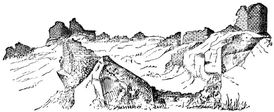
Ruined Pueblo on the Hovenweep.—Utah.
HOVENWEEP RUINS.
From the McElmo Mr Jackson and his party struck off westward to a small stream called the Hovenweep, eight or ten miles distant. Here they found a ruined town, of which a general view is given in the cut. Mr Jackson's description is as follows: "The stream referred to sweeps the foot of a rocky sandstone ledge, some forty or fifty feet in height, upon which is built the highest and better-preserved portions of the settlement. Its semicircular sweep conforms to the ledge; each little house of the outer circle being built close upon its edge. Below the level of these upper houses, some ten or twelve feet, and within the semicircular sweep, were seven distinctly-marked depressions, each separated from the other by rocky débris, the lower or first series probably of a small community-house. Upon either flank, and founded upon rocks, were buildings similar in size and in other respects to the large ones on the line above. As paced off, the upper or convex surface measured one hundred yards in length. Each little apartment was small and narrow, averaging six feet in width and eight feet in length, the walls being eighteen inches in thickness. The stones of which the entire group was built were dressed to nearly uniform size and laid in mortar. A peculiar feature here was in the round corners, one at least appearing upon nearly every little house. They were turned with considerable care and skill; being two curves, all the corners were solidly bound together and resisted the destroying influences the longest." The following cut presents a ground plan of this Hovenweep Pueblo town, and terminates the account of one of the most interesting antiquarian explorations of modern times.
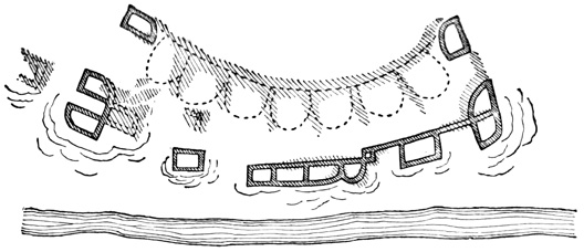
Ground Plan—Town on the Hovenweep.
I append a few brief quotations from the diary of Padres Dominguez and Escalante, who penetrated probably as far as Utah Lake in early times, referring to three places where ruins were seen, two of which cannot readily be located. On the Dolores River "on the southern bank of the river, on a height, there was anciently a small settlement of the same plan as those of the Indians of New Mexico, as is shown by the ruins which we examined." A ruin is also located on this river at the southern bend, on the U. S. map of 1868. On the Rio de San Cosme, "we saw near by a ruin of a very ancient town, in which were fragments of metates, and pottery. The form of the town was circular as shown by the ruins now almost entirely leveled to the ground." In the cañon of Santa Delfina "towards the south, there is quite a high cliff, on which we saw rudely painted three shields, and a spear-head. Lower down on the north side we saw another painting which represented in a confused manner two men fighting, for which reason we named it the Cañon Pintado."[XII-44]
In Idaho and Montana I have no record of ancient remains, save a cliff at Pend d'Oreille Lake, on which are painted in bright colors, images of men, beasts, and pictures of unknown import. The natives are said to regard the painted rock with feelings of great superstition and dread, regarding the figures as the work of a race that preceded their own in the country.[XII-45]
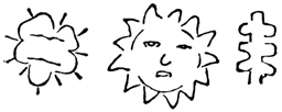
Rock-Carvings—Columbia River.
In Oregon aboriginal remains, so far as reported, are hardly more abundant. The artist of the U. S. Exploring Expedition sketched three specimens of cliff-inscriptions on the Columbia River, which are shown in the cut. Mr Pickering thinks that the figures present some analogies to the sculptures reported by Humboldt on the Orinoco.[XII-46] Mr Abbot noted "a few rude pictures of men and animals scratched on the rocks" of Mptolyas cañon.[XII-47] Lord speaks of little piles of stones about natural pillars of conglomerate, on Wychus Creek, but these were doubtless the work of modern Snake Indians, who left the heaps in honor of the spirits represented by the pillars.[XII-48] A gigantic human jaw is reported to have been dug up near Jacksonville in 1862;[XII-49] and finally Lewis and Clarke found a village of the Echeloots built "near a mound about thirty feet above the common level, which has some remains of houses on it, and bears every appearance of being artificial."[XII-50]
ANTIQUITIES OF WASHINGTON.
In Washington, besides some shell ornaments and arrow-heads of flint and other hard stone dug by Mr Lord from a gravel bank near the old Fort Walla Walla, and some rude figures mostly representing men carved and afterwards painted on a perpendicular rock between the Yakima and Pisquouse, pointed out by a native to Mr Gibbs,[XII-51] there seem to be remains of antiquity in only two localities. The first are the mounds on Bute Prairie, south of Olympia. They were first found, or mentioned, by Wilkes in the U. S. Exploring Expedition, in 1841, who describes them as thousands in number arranged in fives like the 'five spots' on a playing card, formed by scraping together the surface earth, about thirty feet in diameter and six or seven feet high. Three of them were opened, but proved to contain nothing but a pavement of round stones in the centre and at the bottom, resting on the subsoil of red gravel. The natives said that the medicine men in later times were wont to gather herbs from their surface, as being more potent to work their cures than those growing elsewhere. Since Wilkes' visit the newspapers have reported the discovery of a large mound at the south end of the prairie, twenty-five miles from Olympia, which is three hundred feet high and nine hundred feet in diameter at the base. These later reports state also that all the small mounds opened in recent times have been found to contain remains of pottery and "other curious relics, evidently the work of human hands."[XII-52]
The second locality where remains are found is on the lower Yakima River, where Mr Stephens saw an earth-work consisting of two concentric circles of earth about three feet high with a ditch between them. The outer circle is eighty yards in diameter, and within the inner one are about twenty cellars, or excavations, thirty feet across and three feet deep, like the cellars of modern native houses scattered over the country without, however, any enclosing circles. These works are located on a terrace about fifteen feet high, bounded on either side by a gulley.[XII-53]
In British Columbia, some sculptured stones are reported to have been found at Nootka Sound, in which a fancied resemblance to the Aztec Calendar-Stone was noticed; also during the voyage of the 'Sutil y Mexicana,' a wooden plank was found on the coast bearing painted figures, which I have copied in the cut, although I do not know that the plank has any claims to be considered a relic of antiquity.[XII-54]
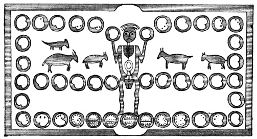
Painted Board—British Columbia.
DEANS' EXPLORATIONS.
Other British Columbian antiquities consist of shell mounds, burial mounds, and earth-works, chiefly confined to Vancouver Island, and known to me through the investigations and writings of Mr James Deans. Mr Deans has lived long in the country, is perfectly familiar with it and its natives, and has given particular attention to the subject of antiquities. He makes no great pretensions as a writer, but has made notes of his discoveries from time to time, and has furnished his manuscripts for my use under the title of Ancient Remains in Vancouver Island and British Columbia. Like other explorers, he has not been able to resist the temptation to theorize without sufficient data on questions of ethnology and the origin of the American aborigines, but his speculations do not diminish the value of his explorations, and are far from being as absurd as those of many authors who are much better known.
VANCOUVER ISLAND.
Burial mounds on Vancouver Island are of two classes, according as they are constructed chiefly of sand and gravel or of stones. One of the first class opened by Mr Deans in 1871, will illustrate the construction of all. It was located on the second terrace from the sea, the terraces having nearly perpendicular banks of fifty and sixty feet respectively. By a carefully cut drift through the centre, it was ascertained to have been made in the following manner. First, a circle sixteen feet in diameter was marked out, and the top soil cleared off within the circle; then a basin-shaped hole, six feet in diameter, smaller at the bottom than at the top, was dug in the centre, in which the skull, face down, and the larger unburned bones were placed and covered with six inches of earth. On the layer of earth rested a large flat stone, on which were heaped up loose stones, the heap extending about a foot beyond the circumference of the central hole. Outside of this heap, on the surface, a space two feet wide extending round the whole circumference was sprinkled with ashes, and contained a few bones also. Outside of this space again, large stones two or three feet long were set up in the ground like pillars, five feet apart, round the circumference; and finally the earth dug from the central hole, or receptacle for the bones, was thrown into the outer circle, and gravel and sand added to the whole until the mound was five feet high, having a rounded form. Four smaller mounds, six and ten feet in diameter, were opened in the same group, showing the same mode of construction, but somewhat less order.
The second class, or stone mounds, which are much more numerous than those of earth, differ but little from the others in their construction, except that the final additions to the mound were of stones instead of earth, and the stones about the circumference were flat and set up close together. A piece of quartz sometimes accompanies the bones, but no other relics are found. When the skeleton is deposited face down, as is usually the case, the skull is placed toward the south, or when in a sitting position, it faces the south, seeming in some cases to have been burned where it sat. In a few instances the skeleton, when it was but little burned, was lying on the left side. The human bones invariably crumbled at a touch, and the author states that this method of burial is altogether unknown to the present inhabitants, who say their ancestors found them as they are.
The mounds are often overgrown with large pine, arbutus, or oak trees; in one case an oak had forced its way up through the stones in its growth, reached its full size, decayed, and the stones had fallen back over the stump. They are often in groups, and in such cases the central one is always most carefully constructed, and a remarkable circumstance is that sometimes the surrounding heaps contain only children's bones. Of course this suggests a sacrifice of children or slaves at a chief's funeral, although there may be some other explanation. Some stones weighing a ton are found over the human remains. Traces of cedar bark or boards are found in some of the cairns, in which the bones were apparently enclosed; and in a few others a small empty chamber was formed over the flat covering stone.
Near Comox, one hundred and thirty miles north-west of Victoria, a group of mounds were examined in 1872-3, and found to be built of sea sand and black mold, mixed with some shells. They were from five to fifty yards in circumference. In one by the side of a very large skull was deposited a piece of coal; and in another with a very peculiar flattened skull was a child's tooth. Both these skulls are said to have been covered with baked clay, and are now in the collection of the Society of Natural History in Montreal. One mound in this vicinity is fifty feet high and of oval shape. In its centre only a few feet below the surface were found burnt skeletons of children not over twelve years old, which seemed to have been enclosed in a box of cedar—of which only a brown dust remains—and covered with two feet of stones and one foot of shells. There is a spring of fine water some fifty yards from this mound, of which, from superstitious motives no Indian will drink. One rectangular cairn, ten by twelve feet, was found, but even in this the central receptacle was circular. The body in this mound showed no signs of burning, the head pointed northward, and a pencil-shaped stone sharp at both ends was deposited with the human remains.
Shell mounds are described as very abundant throughout Vancouver Island, and also on the mainland, and all are composed of species of shells still common in the coast waters. One at Comox covers three acres, and is from two to fourteen feet deep. The relics discovered in mounds of this class include stone hammers; arrow-points of flint, slate, and of a hard green stone; spear-heads, knives, needles, and awls, of stone and bone, one of the knives being sixteen inches long and of whale-bone; bone wedges, sometimes grooved; and finally stone mortars, comparatively few in number, since acorns and seeds were not apparently a favorite article of food. Human skeletons also occur in the shell mounds. At Comox a skeleton is said to have been found with a bone knife broken off in one of the bones. A shell bracelet was taken from a mound at Esquimalt; and from another was dug a stone dish or paint-pot, carved to represent a man holding a mountain sheep. The man was the handle on one side, the sheep's head on the other, and the cup was hollowed out in the sheep's back. Mr Deans believes he can distinguish two distinct types of skulls in Vancouver Island—the 'long-headed' in the older cairns, and the 'broad-headed' in the shell mounds and modern graves: and this distinction is independent of artificial flattening, which it seems was practiced in a majority of cases on skulls of both types.
EARTH-WORKS.
In addition to the mounds, Mr Deans states that earth-works very similar to those found in the eastern states are found at many localities in British Columbia. Indeed, he has sent me several plans, cut from Squier's work on the antiquities of New York, which by a simple change in the names of creeks and in the scale would represent equally well the north-western works. At Beacon Hill, near Victoria, a point one hundred feet high extends three hundred feet into the sea; an embankment with a ditch still six feet deep, stretches across on the land side and protects the approach; there are low mounds on the enclosed area, the remnants of ancient dwellings, and down the steep banks are heaps of shells, with ashes, bones of sea-fowl, deer, elk, and bears, among which are some spear and arrow points, needles, etc. On the summit of Beacon Hill, near by, are burial cairns of the usual type.
Another earth-work was examined by Mr Deans at Baines Sound and Deep Bay. This was an oval embankment surrounded at the base by a ditch, close to the water on the bay side, but now seventy yards from high-water mark on the side next the sound, although originally at the water edge. From the bottom of the ditch to the top of the embankment or mound is forty feet, and at the summit a parapet bank now four feet high encloses an area of over an acre. On the sound side is an opening from which a road runs down the slope of the mound and across the ditch by a kind of earthen bridge. Excavation showed a depth of nine feet of shells, ashes, and black loam. Many burial mounds are scattered about which have not been opened.
I am inclined to regard Mr Deans' reports as trustworthy, although of course additional authorities are required before the accuracy of his observations respecting the burial mounds, and the existence of earthworks bearing a strong resemblance, as he claims, to those of the eastern states can be fully accepted. Respecting the mounds I quote in a note from Mr Forbes, the only other authority I have been able to find on the subject.[XII-55]
In Alaska I find no record of any antiquities whatever, although many curious specimens of aboriginal art, made by the natives still inhabiting the country since the coming of Europeans, have been brought away by travelers. Cook saw in the country several artificial stone hillocks, which seemed to him of great antiquity, but he also noted that each native added a stone to burial heaps on passing; and Schewyrin and Durnew found on one of the Aleutian Islands three round copper plates bearing letters and leaf-work, said to have been thrown up by the sea; but I suppose there is no evidence that they were of aboriginal origin.[XII-56]
CONCLUSION.
Thus have I gone over the whole extent of the Pacific States from the southern isthmus to Bering Strait, carefully examining, so far as written records could enable me to do so, every foot of this broad territory, in search for the handiwork of its aboriginal inhabitants. Practically I have given in the preceding pages all that has been written on the subject. Before a perfect account of all that the Native Races have left can be written, before material relics can reveal all they have to tell about the peoples whose work they are, a long and patient work of exploration and study must be performed—a work hardly commenced yet even in the thickly populated centres of old world learning, and still less advanced naturally in the broad new fields and forests of the Far West. In this volume the general reader may find an accurate and comprehensive if not a very fascinating picture of all that aboriginal art has produced; the student of ethnological topics may found his theories on all that is known respecting any particular monument here spread before him, rather than on a partial knowledge derived by long study from the accounts in works to which he has access, contradicted very likely in other works not consulted,—and many a writer has subjected himself to ridicule by resting an important part of his favorite theory on a discovery by Smith, which has been proved an error or a hoax by Jones and Brown; the antiquarian student may save himself some years of hard labor in searching between five hundred and a thousand volumes for information to which he is here guided directly, even if he be unwilling to take his information at second hand; and finally, the explorer who proposes to examine a certain section of the country, may acquaint himself by a few hours' reading with all that previous explorers have done or failed to do, and by having his attention specially called to their work will be able to correct their errors and supply what they have neglected.
If the work in this volume shall prove to have been sufficiently well done to serve, in the manner indicated above, as a safe foundation for systematic antiquarian research in the future, the author's aim will be realized and his labor amply repaid.