Chapter IX · THE PLAIN FROM THE AIR (Figs. 34 to 41)
Reading edition
A River on the Great Plains
The difficulty of photographing a plain from a point on its surface needs no emphasis, but its successful representation by means of air photographs is illustrated by many figures in this book. The Great Plains of the west-central part of the United States are illustrated here by a view of the Red River (Fig. 36), which shows the flat surface of the land and the broad sandy bed of the river only partly covered by the intricately woven strands of the braided channels—a scene characteristic of the Great Plains.
Meandering Streams on the Coastal Plain
The ox-bow curves of meandering streams are among the features of the earth’s surface most familiar to the student of physical geography; yet, heretofore, they have been illustrated only by maps, constructed at great labor and expense. Comprehensive photographs of them are rare and are, at best, imperfect and unsatisfactory for purposes of illustration. On the other hand, meandering streams lend themselves admirably to air photography. Equally familiar to the student of geography and physiography is the term “abandoned meander.” These ancient stream courses, many of which are now occupied by marsh, brush, or forest, have been still more difficult to illustrate by means of photographs. In some instances wooded meanders like those near Columbus, Ga. (Fig. 34), long ago abandoned by the stream that formed them, are shown in air pictures in a manner but little less conspicuous than the meanders of the present-day stream. It is believed that instructors will find Figure 34 useful, not only in illustrating meandering streams and abandoned meanders but also in showing how meanders develop.
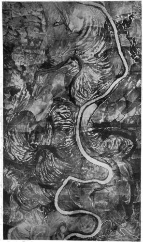
Fig. 34—The Chattahoochee River south of Columbus, Ga., showing the results of progressive lateral shifting of a meandering stream. In the upper part of the illustration to the left (west) of the stream are light-colored concentric markings which probably represent the gradual shifting of the stream toward the right. As interpreted from the information at hand, this section of the stream at one time occupied a position much farther west than now. It cut away the bank on the east, forming a curved course, depositing sand and mud on the inside of the curve. This typical feature of stream erosion and deposition is to be noted from the picture of the present course of the stream. At the outside of each meander stretches of the bank appear light-colored and denuded of the trees and bushes that line the bank elsewhere. These are scours, a slipping away of the bluff caused by the cutting of the stream into the foot of the bank at points where the velocity of the outside of the current, and consequently its corrosive power, is increased as it swings round the curve. The inside of the sharpest meander shows also the deposit of material due to the fact that the velocity of the inside of the current is checked by the bank, causing it to deposit some of its load. Added to this deposit is much of the material brought by cross-currents from the opposite-lying scour. The light-colored banks are probably successive deposits. Finally, either by a gradual wearing away or by some whim of the current at flood tide, the river chose a shorter course, leaving its old channel as an abandoned meander. Farther south several abandoned meanders may be distinguished, each distinctively marked by a steep bank on the outside of the curve and concentric bandings on the inside. The abandoned channels are especially marked by the trees and brush that fill them in many places. It appears that a well-developed growth of trees is to be found only along the river banks in this region and the growth in the abandoned channels is probably due to the fact that in flood time there is much seepage of water into these old channels if not an actual overflow from the present course of the stream. At the bottom of the picture is to be seen the recently made land under cultivation. The fields appear striated and checkered, obscuring the concentric banding. The illustration is from a mosaic made up at Camp Benning near-by of many photographs matched together, hence there are certain differences in shade due to dark and light prints. Scale, about 1:38,000.
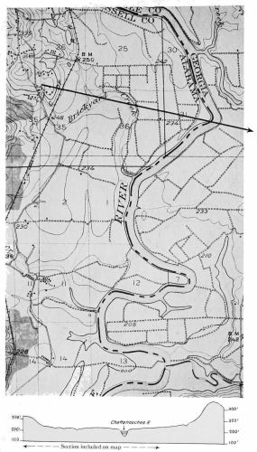
Fig. 35—Map of the same area shown in Fig. 34 enlarged from the corresponding sections of the Columbus and Seale, Ga.-Ala., topographic sheets, 1:62,500, published by the U. S. Geological Survey. The cross section at the bottom lies along the line indicated on the map and extends somewhat beyond the right border of the map. The section shows between the hills the broad lowland over which the Chattahoochee River has meandered. Scale, 1:38,000.
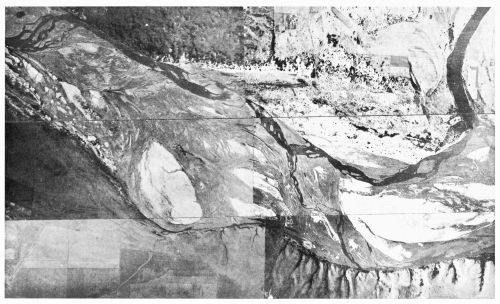
Fig. 36—A river channel in the Great Plains. The Red River northeast of Wichita Falls, Tex., as photographed from a height of 8,000 feet, September 12, 1918. Between the bluffs is seen the dark-colored water of the braided stream flowing on a broad sandy bed more than a mile wide, which is completely covered with water only at flood time. The river forms the Texas-Oklahoma boundary, and frequent changes in the position of the channel during periods of high water make the exact position of the interstate boundary uncertain and give rise to disputes and litigation over the ownership of land. North of the river (top of figure) to the right are sand dunes with a sprinkling of trees and bushes; in the middle of the channel there is an island of light-colored sand. The stream channel bites sharply into the southern bluff, which is cut by many strong gulches. Across the river is the familiar sand flat built of the material washed downstream at flood time and spread out by the subsiding water. The channel at this point shows the changes that have taken place in the position of the stream and, where the stream crosses the sandy floor, affords an example of braiding. Scale, about 1:23,000.
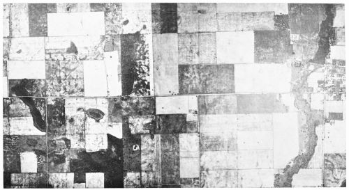
Fig. 37—A characteristic glacial drift plain in southwestern Michigan. There appear, at the left, the round surface of a terminal moraine and gullied slopes, which show mottled in the picture; morainic hollows and kettleholes once partly filled with water but now filled with peat or occupied by marshes formed by the accumulation of peat from plant growth until carbonaceous matter has replaced the water of the original lake; in the center, a relatively smooth outwash plain characterized by straight roads and well-cultivated fields; and, at the right, a brush-lined creek, a small reservoir, and the town of Flowerfield. Scale, about 1:20,000.
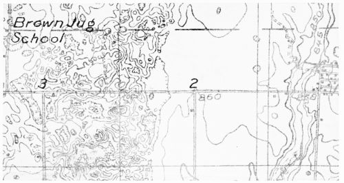
Fig. 38—The same area as shown in Fig. 37, enlarged from the advance edition, 1:48,000, of the Schoolcraft, Mich., topographic sheet to be published by the U. S. Geological Survey. This advance sheet results from an experiment in the use of airplanes for mapping. The area was photographed with a mapping camera. From the photograph a base map was constructed, which was verified on the ground; on this base the contour lines were added by instrumental survey. Scale, 1:20,000.
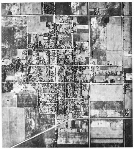
Fig. 39—Schoolcraft, Mich., a town typical of the agricultural portions of the north-central United States, showing the characteristic features—roads, fields, town blocks, and others—by which the aviator can recognize a locality from a distance. The mottled appearance of the land surrounding the village is characteristic of air photographs of glacial moraine regions. The picture of the village itself might be taken as a prototype of the American village with its fairly regular layout of streets, its business center indicated by a few larger roofs along the widest street, its lawns, trees, and gardens, the bordering farm lands, and the scattered extensions of the village into points in the direction of the main roads. Scale, about 1:14,000.
The Glacial Drift Plain
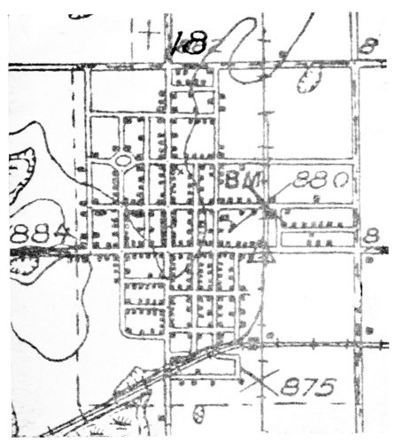
Fig. 40—Map of the town of Schoolcraft, Mich., for comparison with Fig. 39. Enlarged from the advance edition, 1:48,000, of the Schoolcraft, Mich., topographic sheet to be published by the U. S. Geological Survey. Scale, 1:14,000.
Some of the characteristics of a third type of plain, the glacial drift plain, are shown in Figures 37 to 41. Here are pictured glacial lakes, bogs, marshes, moraines, and outwash plains, peat-filled depressions, kettleholes and gullied slopes—typical features of a glaciated region. The views show, also, many of the familiar aspects of the central and western parts of the United States: the rectangular pattern formed by the land subdivisions established by the United States Land Office, the checkerboard pattern being emphasized by the section-line roads; the minor subdivisions into fields; and the cultivation of a variety of crops.
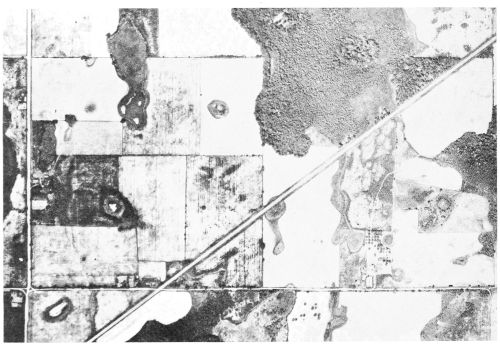
Fig. 41—Kettleholes and other depressions in glacial till, on the Grand Trunk Railway about 5 miles southwest of Schoolcraft, Mich. The distance between the eastern (right) edge of this view and the western (left) of Fig. 37 is about 1 mile. Scale, about 1:15,000.
These photographs were selected from a series taken as an experiment in map-making. In June, 1920, the United States Air Service sent a plane equipped with a K-1 camera from Dayton, Ohio, to Schoolcraft, Mich, where in seven hours’ flying time a fifteen-minute quadrangle, about 220 square miles, was photographed. The prints were matched together and reduced to a scale of 1:48,000. From them such features as roads, streams, forests, land corners, etc., were transferred to plane-table sheets, which the topographic engineers on the ground then used for contouring the relief. Figure 38 is a part of the preliminary proof of this map. It may be added that the experiment is regarded as highly favorable to the use of the airplane camera as an instrument in mapping.