Chapter VIII · SUBMERGED LAND FORMS (Figs. 30 to 33)
Reading edition
Heretofore the study of beaches, deltas, and other partly submerged land forms has been chiefly confined to the exposed parts, the underwater forms being largely matters of conjecture. By means of air photographs not only can the exposed parts of the delta and beach be studied, but the forms of shoals and terraces, the underwater portions of river deltas, tidal deltas and their underwater distributaries, and many other submerged forms can be shown clearly. Sand bars, terraces, and other submerged forms appear in many of the photographs already presented; but a few so taken that the bars and terraces appear to be the chief objects in the picture may be useful for illustrating the underwater land forms and for demonstrating that these forms can be successfully photographed. Unfortunately not many photographs could be found which were taken with the express object in view of illustrating underwater land features. In most of the available photographs these features were only incidental, the chief purpose in taking them being to photograph the shore.
Much has been written concerning the physiographic history of the Atlantic Coastal Plain of the United States, and the question is still being debated whether the land is rising, sinking, or stationary. To some extent these questions are answered by the exposed land forms. The submarine forms are imperfectly known. The possibility of recognizing shoals and channels from a photograph and of determining in some measure the shapes of the submerged land forms opens a new avenue of approach to the study of submarine geography. In some places, especially in regions of drowned topography, it is possible that, by using the air photograph in working out the physiographic processes that have produced the land forms that are now under water, some of the vexing problems of earth history may be solved.
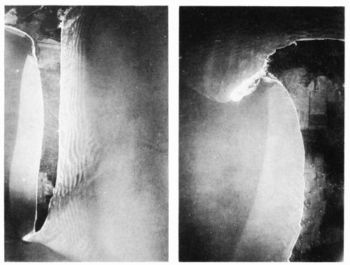
Fig. 30 (left)—Sand bars and drowned terrace about Stove Point Neck, at the mouth of the Piankatank River, Virginia, as photographed from a height of about 10,000 feet at 11:30 A.M., December 11, 1920. West (left) of the neck, at the outer edge of the terrace, the water is 2 to 3 feet deep at low tide, or 5.7 feet and 6.7 feet at high tide, but deepens abruptly westward, where it is 20 to 30 feet deep in Fishing Bay (see Fig. 32). To the south and east of the point the abrupt descent is at the side of the deep channel of the Piankatank River. To the right, the bottom, having a wavy appearance because of sand bars, fades off more gradually under deep water. The mottled area in the middle of the neck is wooded, and the smoother parts near the point and in the upper part of the neck are cleared land. Scale, about 1:30,000. Fig. 31 (right)—Drowned terraces at Gwynn Island at the mouth of the Piankatank River, Virginia, as photographed from a height of about 10,000 feet at 11:30 A.M., December 11, 1920. At the right is a part of the island, showing trees, fields, and houses. Bordering the land area is a narrow band of light-colored beach sand, expanded at Cherry Point into a conspicuous sharply recurved hook. Under the shallow water can be seen wave marks resembling large ripple marks. The water is 2 to 3 feet deep at low tide at the outer edge of the light-colored submerged shelf, beyond which the bottom descends abruptly toward the left to a depth of about 20 feet. North of Cherry Point the waxy bottom shades off more gradually to the deep channel of the Piankatank. Scale, about 1:30,000.
The Best Conditions for Photographing Underwater Land Forms
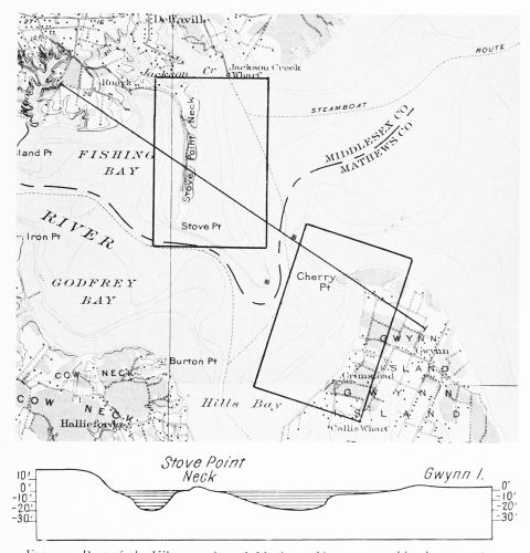
Fig. 32—Part of the Kilmarnock and Mathews, Va., topographic sheets, 1:62,500, published by the U. S. Geological Survey, showing the location of Figs. 31 and 32; and a cross section along the line indicated on the map, showing a terrace 26 feet above sea level at the left, one less than 5 feet above water level on Gwynn Island, one 5 feet or less below water level; and the river channel with abrupt banks between the shoals. Scale, 1:70,000.
The photographic study of underwater land forms is relatively new, and little information concerning it is available. It is annoyingly obvious to the air observer that at times he can see nothing beneath the surface of the water, whereas at other
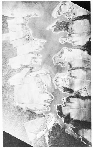
Fig. 33—A drowned valley: Lambs Creek, 8 miles southeast of Yorktown, Va., one of the estuary-streams tributary to Chesapeake Bay, showing the broad mouth narrowing upstream and the irregular margins caused by partial submergence of the valley slopes, eroded before the rise of the water to its present height. Even the vertical photograph, which does not register relative elevations, shows a distinct difference between the shore line of this type of body of water and rivers with broad, low flood plains. The large trees close to the margin of the river and the cultivated fields just back of them indicate a relatively high bank. Scale, about 1:9,000.
times he can see with great distinctness. In trying to ascertain the most favorable conditions for such observation, it was found that submerged objects are seen best when the sky is evenly overcast or when it is uniformly clear. Sometimes when the sky is only partly cloudy the surface of the water seems to act as a mirror and nothing is seen but the reflection of cloud and sky. Waves have less effect on the visibility of objects beneath the surface than was expected, although they diffuse the reflected light to some extent and consequently weaken the image on the negative. But the reflected light from the surface of the water is stronger than that coming from objects under water. Hence, to photograph underwater features successfully, a time should be chosen when direct reflection of light from the sun or from a brightly illuminated cloud will not enter the lens.
Experience in both the air and the laboratory shows that the best results are likely to be obtained when the sunlight strikes the surface at an oblique angle. In summer favorable times are mid-forenoon or mid-afternoon under an evenly illuminated sky. In winter the sun is low enough at midday to avoid direct reflection into the lens. But experience also indicates that often photographs taken at moments when the eye caught the image of a submerged object show only the surface of the water.