Chapter V · GENERAL ASPECTS OF THE SURFACE AS SEEN FROM THE AIR (Figs. 12 to 18)
Reading edition
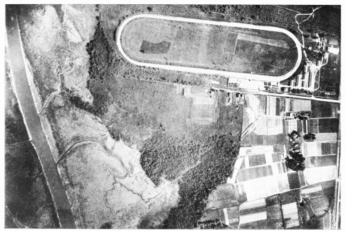
Fig. 12—Benning, D.C., and the Anacostia River, showing, from right to left, cultivated lands 40 to 20 feet above sea level, an elevation too slight to be shown in a vertical photograph; a brushy slope running from 20 feet to sea level; and marshland along the stream. The checkered pattern of the upland fields is caused by different-colored crops. Shocks of corn, spaced evenly in rows, buildings and shade trees, and light-colored roads and a race track are shown. The light-colored areas along the stream are occupied by tidal marsh and are free from brush but covered with vegetation of annual growth. The figure is one of the photographs used to make the mosaic shown on Fig. 13. It should be compared with Fig. 13 and with the topographic map, Fig. 14. Scale, 1: 11,000.
When a region is viewed from an altitude of several thousand feet the observer can readily imagine himself looking down on a large map. The chief features stand out prominently, the smaller to a lesser degree. Mountains, rivers, and the seashore are
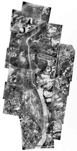
Fig. 13—Vertical photograph of the land along the Anacostia River on the eastern edge of Washington, D.C., made up of several photographs matched together and adjusted to points located by ordinary survey methods, and reduced in size to correspond with the map, Fig. 14. The photographs were taken from an airplane with a so-called mapping camera at such intervals of time that the prints overlap, thus making it possible to adjust them to each other and to form a continuous picture of the area. The region shown is the site of improvements that are at present under way, mainly the regulation of the Anacostia River. The channel has been widened by dredging and part of the bordering marsh areas filled in. The photograph shows that this work had progressed to the Benning Road bridge by the autumn of 1920, when the photograph was taken, while in 1915, when the area was surveyed for the map, it had been carried out only as far as the Pennsylvania Avenue bridge. Such airplane photographs furnish an incomparable tool in the handling of large-scale engineering projects, both in the study of the territory in its unimproved state and to follow the progress of the work after operations are under way. Scale, about 1: 28,000.
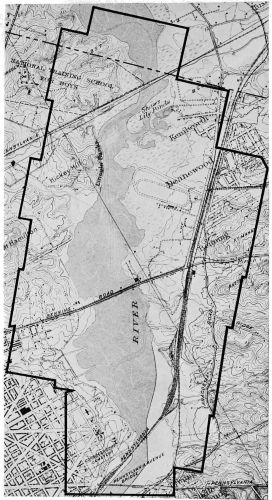
Fig. 14—Part of the topographic map of Washington and Vicinity, 1: 31,680, published by the U.S. Geological Survey, showing within the irregular line the same area shown in Fig. 13. Scale, 1: 28,000.
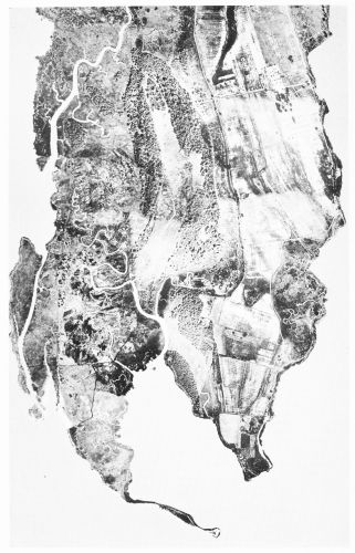
Fig. 15 (on page 24)—Mosaic of the southeastern part of Mulberry Island, on the left bank of the James River about 11 miles northwest of Newport News. Va., showing an area portrayed by many photographs matched together. Slight differences in shade indicate the junction of the separate prints. The higher land, about 10 feet above sea level as determined by surveys on the ground, is shown at the right by roads and cultivated fields. It is to be noted that roads outline the dividing line between the high ground and the marsh. At the left are lower areas of wooded or brushy swampland and of grassy marsh. They contain a number of abandoned channels: some completely silted up, others containing small thoroughfares, and still others drained by meandering streams which seem to have developed after the channels were definitely abandoned by the streams which originally occupied them.
The streams which drain the marshes have many characteristics of streams which drain higher lands. They have dendritic patterns, so called from resemblance to the forking branches of a tree; channels which widen downstream; and winding or meandering courses. The island terminates in a long spit composed of silt and fine sand. The banks to the left on James River are low and marshy: those to the right on Warwick Creek, except for one small marsh, form low bluffs.
In order that the mosaic may be compared with the map, Fig. 16, it has been placed with the northerly part at the top of the page, with the result that, until the page is reversed, the trees in the swampland appear like hollows in the earth. Scale, 1:14,000.
especially conspicuous. Streams appear as smooth, winding ribbons—glistening if the sunlight reflected from them enters the eye, dark if the bright rays are reflected away from the eye. Railroads can easily be traced and towns recognized by their form. Concrete roads and others of light-colored material are plainly visible. Those built of dark-colored material appear less prominently. Something even of the character of the forests can be ascertained—whether evenly timbered or partly of primary and partly of secondary growth; whether intact or partly burned over; whether consisting chiefly of one species of trees or of many. The cultivated fields and their relations to roads, streams, and forests are conspicuous. Towns and cities are spread out like panoramic views in which are strikingly visible the residence and manufacturing centers, the layout of streets, the systems of parks, the position of suburbs, and the relation of these to routes of transportation and travel—roads, railroads, and waterways. These and many other features of the landscape—swamps, marshes, buildings, trees, orchards, and many lesser details—are recognizable and are all recorded on the
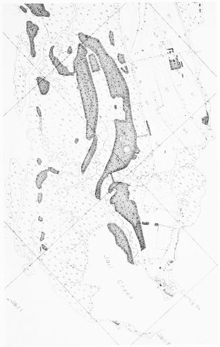
Fig. 16—The same area as shown in Fig. 15 reduced from a section of a map on the scale of 1:10,000 by the Corps of Engineers, U.S.A. The photographs shown in Fig. 15 were used for mapping certain small features on this map, such as small streams. Scale, 1:14,000.
photographic negative. So faithfully does the camera reproduce all the horizontal features within its range of vision that it is conceivable that a photograph correctly dated might become a valuable record in cases of boundary disputes or other litigations involving the position of fences, fields, roads, or even streams, at a given date.
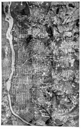
Fig. 17—Columbus. Ga. A part of a mosaic made at Camp Benning near-by in 1909 showing the town, river, and surrounding country. The scale is so small that buildings and trees appear as dots, city blocks as small parallelograms, streets and roads as light-colored lines. The cultivated fields appear as irregularly checkered areas, and the concentric lines of the terraced slopes have the appearance of contour lines on a topographic map (see Fig. 18). The picture illustrates many of the features of city geography. The comparatively straight course of the river and the heavy growth of trees and bushes along its edges indicate a minimum of flood-plain and steep banks—an inference supported by the fact that the principal business center of the city, shown by large, closely set roofs, is built close to the river. Surrounding this section is the most densely populated district, which in the northern part of the city gives way to a district of houses set farther apart and separated by lawns set with trees. Other less extensive business centers are shown as small spots of closely grouped buildings. A variety of suburban types is to be seen: some quite city-like, with a business center, a densely populated residential district, and a district of houses separated by grounds; others more village-like in their lack of a well-developed center but still more or less completely separated from the city proper; still others, sporadic scatterings of houses and grounds extending from the city for some distance along the principal roads. The railroad center is located conveniently near the business center, and the radiating lines of road and railroad communications are in strong contrast to the rectangular arrangement of the city streets. Factories, indicated by large, light-colored roofs, are located along the railroad in the southern part of the city and along the river to the north. Those along the river are operated by power from the falls which the picture shows. The terraced slopes are characteristic of the region, the farmers here and elsewhere in the South making these terraces in their plowed fields to prevent rain water from washing away the soil. Scale, about 1:38,000.
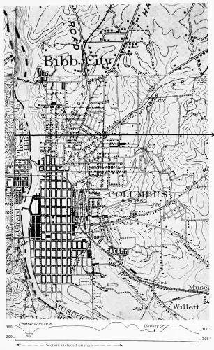
Fig. 18—Map of the same area shown in Fig. 17 enlarged from the corresponding sections of the 1:62,500 Columbus and Seale, Ga.-Ala., and the 1:125,000 Talbotton and Opelika, Ga.-Ala., topographic sheets surveyed mainly in 1906 and 1907 and published by the U.S. Geological Survey. The cross section at the bottom lies along the line indicated on the map and extends somewhat beyond the right border of the map. The section shows the broad shelf upon which the city rests and its relation to the river and to the terraced hillsides east of it. Scale, 1:38,000.