Chapter VI · MARSHES AND MARSH DRAINAGE (Figs. 19 to 27)
Reading edition
Mention has been made of the objects seen better from the air than from any viewpoint on the ground; but there are some objects which as a whole can be seen only from above. Swamps, parts of everglades, peaks in the midst of difficult country, precipitous canyon walls, and many volcanic craters cannot be seen from the ground without undue effort. Photographs of bluffs, terraces, and other slopes facing bodies of water have hitherto been adequately obtainable only from the water. All of these can be readily viewed and photographed from the airplane. Pictorial representations of drainage systems were rare until photographs such as Figure 19 were taken from airplanes. The intricate drainage of marshes like those along the Pamunkey River in Virginia pictured in Figure 20 was never accurately shown until photographed from the air.
Of frequent occurrence on the Atlantic Coastal Plain of the United States are swamps and marshes inaccessible from the ground. Much of the surface material is so soft that they cannot be easily traversed; and, even where firm enough to support a man’s weight, few of the details are deemed of sufficient importance to warrant the trouble and expense of mapping by ordinary methods. Yet the trapper would scarcely admit that these details are unimportant, and, to the student, they are an interesting feature of marsh topography that has thus far received little attention.
Figure 25 is part of the excellent New Kent, Va., sheet of the topographic map and is probably as detailed as a map of this character should be when made from ground surveys only. However, on comparison of the map with a photograph of the same area (Fig. 24), there is no difficulty in detecting errors; and it is probable that, had the photograph been available when the map was made, the marshes would have been represented differently.
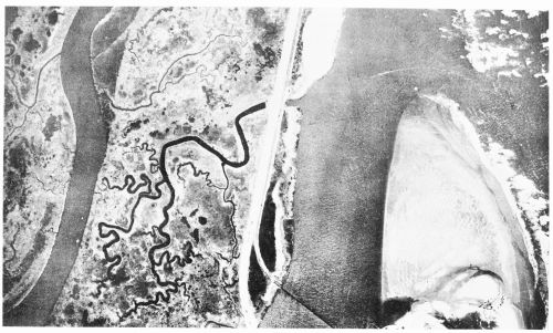
Fig. 19—Stream development in a tidal marsh, showing, at the right, the northern end of Ludlam Beach, about 6 miles south of Ocean City, N.J., and the mouth of Corsons Inlet leading to Ludlam Bay, and, at the left, the marsh just west of the inlet, with streams rising close to the bank of the larger stream at the extreme left and flowing in meandering courses across the marsh. The great variety of types of vegetation probably is one cause of the remarkable meandering of these drainage lines by reason of the fact that the accumulated remains as well as the annual growth of different weeds and grasses offer varying resistance to the current of the streams. Scale, about 1:10,000.
Marsh Drainage
One of the most striking characteristics of marsh topography illustrated by the photographs presented here is the great wealth of drainage lines and the resemblance of the drainage patterns to those of river systems developed on higher ground. The dendritic patterns, the meanders, and the sharply outlined divides are surprising in areas which have altitudes varying from only a few inches to a little more than a foot at times of ordinary high tide and which are wholly submerged at times of maximum tide. Some of the streams have gently winding courses suggestive of normal stream development. Others, particularly the smaller, have a conspicuous angularity of course. It is possible that the latter may have originated as the trails of animals. Some of the lines are observed to cross the larger streams and are probably tracks made by muskrats. Some of the streams rise close to the river’s brink and lead to through-going waterways near the center of the marsh. This suggests the deposition of silt on the brink of the river at times of high water. The notched appearance of the shore in Figure 20 seems to be due to overhanging bunches of sedge grass and, in some instances, to the breaking away of the surface mat or crust of the marsh formed by the interlacing roots of grass. The mottled appearance of the marsh in this picture may be partly due to shadow of clouds, but to some extent, at least, the difference in shade is caused by differences in the character of the plants.
The marshes used for illustration here are typical of many along the Atlantic Coast. They are situated near West Point, Va. The Pamunkey and the Mattaponi Rivers both rise in the Piedmont Plateau, flow southeastward through the tidewater portion of Virginia, and join about midway of the Coastal Plain to form the York River[3] (see Fig. 58).
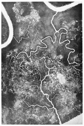
Fig. 20—Details of marshland. A part of Lee Marsh near West Point, Va. (cf. Fig. 26), as photographed from a height of 2,000 feet, June, 1920. Local observers report that this marsh has been submerged only twice in nineteen years. The drainage systems are well entrenched. The larger stream channels are cut 1 to 5 feet or more below low tide (the tidal variation at West Point is about 3.4 feet), and their form is made stable by the tough surface crust of the marsh, consisting of the matted roots of the luxuriant sedge grass. The intricate, veinlike appearance of the drainage lines and the furry appearance of the edges of all the waterways, showing overhanging vegetation, are of interest. Drainage systems flowing in opposite directions slow connecting tributaries apparently silted up. Scale, about 1:4,000.
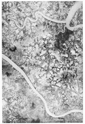
Fig. 21—Details of frequently submerged marshland. A part of Cousaic Marsh on the Pamunkey River, near Sweet Hall, Va. (cf. Fig. 24), as photographed from a height of 2,000 feet, June, 1920. The surface of the marsh is covered with water several times each year, according to local report. It is relatively soft, and a comparison with Fig. 20 shows an apparently different, less dense vegetation than that of Lee Marsh, which is rarely submerged. The stream channels are less definitely fixed and lack the evidence of overhanging vegetation. Scale, about 1:4,000.
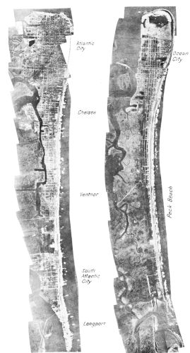
Fig. 22—Atlantic City and Ocean City, N.J. Strips of photographs taken from an airplane, March, 1920, from a height of 10,000 feet, showing, in order from east to west: the ocean water, which appears dark-colored; the surf, white where it breaks into foam; the light-colored beach sand; the cities laid out on the sand of the barrier beach; and the marshes, channels, and drainage systems west of the barrier. West of Peck Beach in the strip of photograph at the right many features characteristic of salt marsh areas of the Coastal Plain are shown back of the barrier beach. The right strip forms the southern continuation of the left strip. Scale, about 1:75,000.
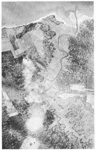
Fig. 23—A river system in miniature. A small stream near Hampton, Va., showing flood plain, meanders, an ox-bow lake and cut-off, abandoned channels and a delta partly under water. Scale, not known.
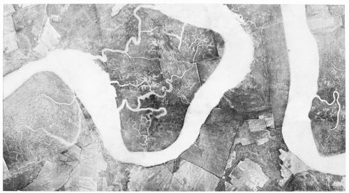
Fig. 24—Sweet Hall Marsh on the lower Pamunkey River, near West Point, Va., as photographed from a height of 10,000 feet at 11 A.M., December 11, 1920. Cousaic Marsh lies to the left and Hill Marsh to the right of the central meander. Some of the watercourses in these marshes are thoroughfares, or channels opening to the river at both ends, that can be traversed by boat at high tide. But many of them are quite different in nature, beginning as minute rills and broadening toward the mouth in a manner suggesting typical drainage channels on higher land. Scale, about 1:31,000.
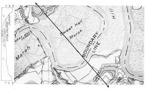
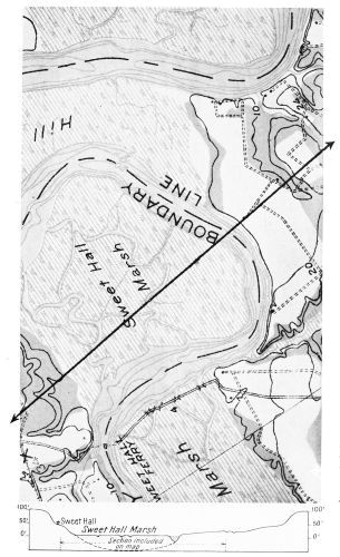
Fig. 25—The same area as shown in Fig. 24, enlarged from the New Kent, Va., topographic sheet, 1:62,500, published by the U.S. Geological Survey. The cross section at the left lies along the line indicated on the map and extends somewhat beyond its borders. The somewhat greater height of the map than of the photograph, although both cover exactly the same area, is due to the unavoidable slight difference in tilt of each of the exposures of which the photographic mosaic is made up. This illustrates the fact that airplane photographs cannot be directly used as equivalent to maps, until the necessary adjustments have been made. Experiments in camera construction are under way to overcome these difficulties by automatic devices. Scale, 1:31,000.
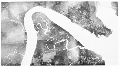
Fig. 26—Eltham Marsh on the lower Pamunkey River, as photographed from an altitude of about 10,000 feet at 11 A.M., December 11, 1920. At the right lies the town of West Point, Va., at the junction of the Mattaponi and Pamunkey Rivers, and at the left appears a part of Lee Marsh. Eltham Marsh, in the center of the illustration, is traversed by a so-called thoroughfare, through which boats of light draft make their way at high tide. At one point in the middle of the marsh the thoroughfare is perceptibly broader than elsewhere, and the tidal currents entering from opposite ends of the thoroughfare meet there and cause slack water in which silt is deposited, forming mud flats exposed at low tide. The cultivated fields south of the marsh are on a bench about 10 feet higher than the marsh. Scale, about 1:31,000.
Fig. 26—Eltham Marsh on the lower Pamunkey River, as photographed from an altitude of about 10,000 feet at 11 A.M., December 11, 1920. At the right lies the town of West Point, Va., at the junction of the Mattaponi and Pamunkey Rivers, and at the left appears a part of Lee Marsh. Eltham Marsh, in the center of the illustration, is traversed by a so-called thoroughfare, through which boats of light draft make their way at high tide. At one point in the middle of the marsh the thoroughfare is perceptibly broader than elsewhere, and the tidal currents entering from opposite ends of the thoroughfare meet there and cause slack water in which silt is deposited, forming mud flats exposed at low tide. The cultivated fields south of the marsh are on a bench about 10 feet higher than the marsh. Scale, about 1:31,000.
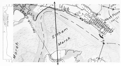
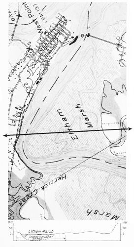
Fig. 27—The same area as shown in Fig. 26, enlarged from the New Kent, Va., topographic sheet, 1:62,500, published by the U.S. Geological Survey. It is obvious that many interesting details shown by the photograph are missed or neglected as unimportant in the most careful mapping. The cross section at the left lies along the line indicated on the map and extends somewhat beyond its borders. Scale, 1:31,000.
The York is one of the estuaries of the tidewater portion of Virginia, and the water level at West Point, the junction of the two tributaries, rises and falls about 3½ feet under tidal action. The Pamunkey is affected by the tide 53 miles by channel above West Point, and the Mattaponi 42 miles. Much of the broad lowland along these rivers is marshy, but the largest marshes are found near West Point, where the river current in swinging from side to side has formed great meanders. For some reason the valleys eroded long ago by these streams have filled with sediment here to a greater extent than farther downstream; perhaps because this is essentially the head of sea water, so that the checking of the current of the river causes it to deposit much of its load. Sea water regularly mingles with the river water as far upstream as West Point, but above this point the water is chiefly fresh. The marshes consist of soft mud and muck to a considerable depth. A well driven in Hill Marsh to an underlying artesian horizon penetrated 50 feet of this soft material before entering rock such as is exposed in the river bank. The thickness of the mud is comparable to the maximum depth of the York farther downstream and suggests that the old valley which there is filled with water is here filled to a depth of 50 feet or more with sediment brought down by the river. Only a small part of the marsh near the landward margin has surface material firm enough to support the weight of large animals except when the surface is frozen.
Many kinds of marsh plants grow here, among which is sedge grass (Spartina cynosuroides (L.) Willd.), which grows to a height of 10 feet or more and forms dense thickets. Its roots interlace to form a tough mat which in some places will support the weight of a man. In other places the soft muck reaches to the surface.
“Thoroughfares”
These marshes are cut by a few waterways open at both ends, known as thoroughfares, or tidal runs, which also serve as the trunk streams through which the marsh is drained. Some of the thoroughfares may be trunk streams modified by tides, or they may be silted remnants of abandoned river channels. Some seem to be channels in the last stages of silting. The incoming tide enters the down-river end but ascends the thoroughfare more slowly than it ascends the river. The tide in the river reaches the upper end of the thoroughfare, enters it, and meets the opposing tide within the marsh near the upstream end of the passageway. Where the tides meet, thus causing slack water, silt is deposited and mud flats are formed. In Eltham Marsh (Fig. 26) these flats are well within the marsh. In the larger thoroughfares of Sweet Hall Marsh (Fig. 24) the tide passes entirely through while the tide in the river is making its long way around, so that slack water and the deposition of silt occur at the extreme upper end of the passage. In all of the thoroughfares the silting has reached the stage that precludes their use by boat, except at times of high water. Even at high tide some are navigable only by small skiffs, although throughout much of the course the water is many feet deep.
Some of the thoroughfares become narrow and shallow upstream in a manner that suggests that they originate as two normal streams flowing in opposite directions from a common point and that they were later united by the breaking down of the divide between their headwaters. Such a junction might be affected by an unusually high tide breaking through a divide and cutting a channel. Such a divide, be it noted, consists of soft mud only a few inches above the general level and might readily be broken down. In some instances the connection may have originated as an animal trail, as we have seen. Muskrats, otters, and other marsh animals use the waterways as lines of travel and make paths in between them from one to another. Apparently many of the small drainage lines originated in this way, but in some instances stream systems of considerable size and complexity are independent of all others and possess all the characteristics of normally developed river systems.