Chapter X · MOUNTAIN FEATURES (Figs. 42 to 52)
Reading edition
In obtaining photographic illustrations from the ground of mountains, canyons, and associated land forms, the same difficulty, but in exaggerated form, is encountered that obtains in securing an advantageous point of view for small objects. The difficulty is overcome in large measure by the use of aircraft. In an airplane the observer can rise above the obstructions which interfere with the view desired; can look an isolated mountain peak squarely in the face, as in the case of the photograph of Mt. Shasta (Fig. 42); can study the details of its ice cap (Fig. 42) and gaze downward on the lateral and recessional moraines left by the retreat of the mountain’s glaciers (Fig. 43). Few volcanic craters, occurring as they do at the top of cones, have been successfully photographed unless some higher mountain stands near-by on which a favorable viewpoint can be found. From an airplane, however, one can look into the very throat of a crater, as into that of Cinder Cone (Fig. 48), near Lassen Peak, California.
Much attention has been given to the interrelations of canyons, gorges, and mountain ridges, but these relations have hitherto been illustrated chiefly by means of maps and charts. Figures 49, 50, and 52 picture three relations more expressively than any map. To the experienced geographer a map may illustrate perfectly the action of a stream working headward into higher land; but the student to whom the conception of headward erosion is new will certainly grasp the idea more readily from the picture presented in Figure 52. No map could give so clear a conception of a maturely dissected highland as does a photograph like that of the Santa Monica Mountains (Fig. 50).
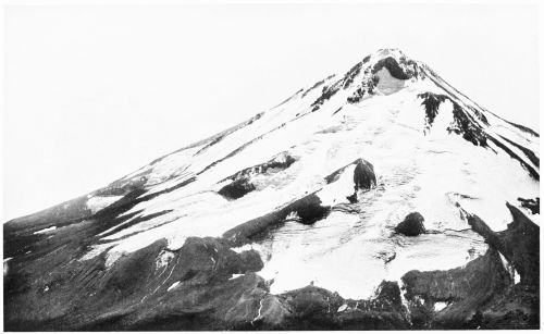
Fig. 42—A glaciated volcanic Cone: Mt. Shasta, California, 14,162 feet high, as seen by an airplane observer from the northeast, showing Hotlum Glacier in the foreground and Wintun Glacier at the extreme left. The monadnock which separates the two main lobes of Hotlum Glacier appears as the dark-colored mass of rock in the midst of the ice. To be noted are the many indications of movement in the glaciers shown by curved lines, eddies, and crevasses, and the glacial streams flowing away from the ends of the glaciers. The long lobe at the left center shows the formation of both lateral and recessional as well as terminal moraines.
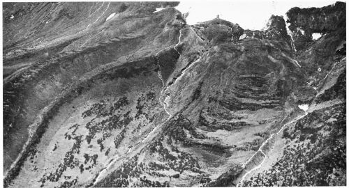
Fig. 43—A glacial gorge on the northeastern face of Mt. Shasta, California, below Hotlum Glacier (see Fig. 42), the lower end of which is to be seen in the upper part of the photograph. At the left are two ridges, one the edge of a sheet of flow lava, the other, in part at least, a lateral moraine. In the center, at the bottom of the gorge, between the two white lines which represent glacial streams, is a system of concentric ridges which are probably recessional moraines. At the right is the western slope of the gorge. (This figure is the lower overlapping continuation of Fig. 42.)
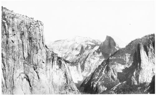
Fig. 44—Yosemite Valley, California, a typical ice-shaped gorge, showing at the left the granite face of El Capitan, about 3,000 feet above the bottom of the famous gorge, and, at the right, the pinnacle of Sentinel Rock and the well-known form of Half Dome. At the sky line in the center of the picture is Clouds Rest, and well down in the gorge Washington Column and the Royal Arches can be distinguished.
These photographs have the advantage of appealing to the mind through the sense of vision and will serve the same purpose as plaster models. Thus, in Figure 52, a variety of topographic forms are to be distinguished, including slightly dissected highlands with sharply incised gorges; maturely dissected highlands made up now of canyons and ridges; a mountain valley broadening out toward an intermontane plain; several arroyos; and many minor features.
In the interpretation of the features shown in a vertical view of a mountainous country the orientation of the photograph is of prime importance. When viewed in proper orientation, that is, as already pointed out (p. 5), with the shadows falling toward the observer, mountains and valleys appear in their correct relation. But, if the position of the picture is reversed, a mountain will look like a depression and a valley like a ridge. This reversal of the image can be tested by looking at Figures 49 or 52 from both viewpoints. However, since the vertical photographs will be compared with maps of the same area, it is thought better to place them on the page as if they were maps. In order to make them appear natural the prints can be turned in the necessary direction.
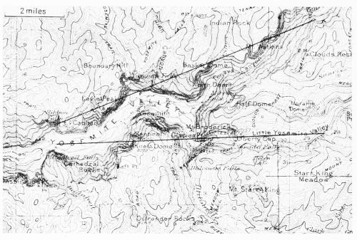
Fig. 45—Map of the Yosemite Valley, showing the area included within the angle of vision of Fig. 44. The map, a reduced section from the Yosemite and Mt. Lyell, Cal., topographic sheets, 1:125,000, published by the U. S. Geological Survey, is oriented for direct comparison with the photograph. Scale, 1:167,000.
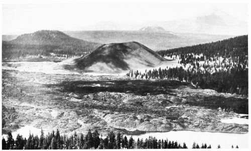
Fig. 46—Mountains of volcanic origin: Cinder Cone with, in the distance at the right, Lassen Peak in the northern Sierra Nevada, California, as seen from an airplane over Lake Bidwell. Beyond the lake appears the rough surface of lava poured out as molten rock less than two hundred years ago (see U. S. Geol. Survey Bull. 79, 1891). Surrounding the cone is a light-colored ash field, sparsely forested at the right, which was formed about two hundred years ago. The mountain in the middle of the photograph having a smooth surface is Cinder Cone, rising 640 feet above the general level of the ash field and consisting of fragments of lava—the so-called ash and cinders—blown from the crater at times of eruption.
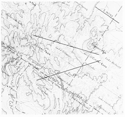
Fig. 47—Map of the region between Cinder Cone and Lassen Peak in the northern Sierra Nevada, California, showing the area included within the angle of vision of Fig. 46. The map, a reduced section from the Lassen Peak, Cal., topographic sheet, 1:250,000, published by the U. S. Geological Survey, is oriented for direct comparison with the photograph. Scale, 1:307,000.
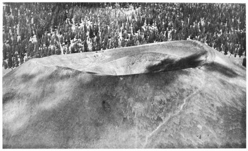
Fig. 48—The top of Cinder Cone, looking from an airplane down into the crater, showing a large saucer-shaped crater 750 feet across, with a deeper crater formed at the time of a later volcanic explosion, which looks like a cup in the middle of the saucer and extends to a depth of 240 feet below the outer rim. On the barren cinder slopes at the right is the pathway by which the crater can be reached.
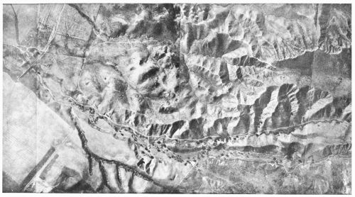
Fig. 49—Mountain, valley, and plain in the Simi Hills about 15 miles northwest of Santa Monica, Cal. (see Calabasas, Cal., topographic sheet), showing, in the right center of the picture, headward erosion from two parallel valleys, in strong contrast with the gently rounded, slightly dissected part of the mountain (left center) into which the streams have not yet eaten their way. Farther up the mountain is more maturely dissected and the divides are narrow and steep. On its top the mountain shows little effect of stream erosion (right). Strongly cut gorges and arroyos appear where the streams enter the plain (left). Probably north is at the bottom of the photograph. Scale, probably about 1:20,000.
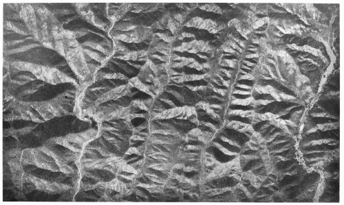
Fig. 50—A maturely dissected highland: Santa Monica Mountains north of Santa Monica, Cal., as photographed from a height of nearly 10,000 feet at a midday in January, 1919. The light-colored irregular line at the left is Sepulveda Canyon; and the similar line at the right, Stone Canyon (for location, see Fig. 51). These mountains rise nearly 1,600 feet above sea level and about 700 feet above the bottom of the canyons.
To obtain the proper impression of ridges and valleys the figure should be reversed. Such photographs as this of the actual ground can hardly be distinguished from photographs of good relief models; they strikingly confirm the correctness of this and similar methods of representing relief on maps, developed intuitively, as it were, such as the Swiss school of hill shading. Scale, about 1:17,000.
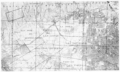
Fig. 51—Map of the region between the center of Los Angeles and Santa Monica, Cal., showing the location of the area covered in Fig. 50 (the double-ruled rectangle in the upper left corner). Reduced from the Santa Monica, Cal., sheet, 1:62,500, of the “Progressive Military Map” of the United States being published by the Corps of Engineers, U.S.A. This sheet, which is the equivalent of the Santa Monica topographic sheet surveyed in 1893 and published by the U.S. Geological Survey, was revised in 1920 by airplane photography. A comparison of the 1893 and 1920 editions brings out strikingly the rapid urban development in this region. Scale, 1:123,000.
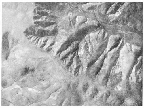
Fig. 52—A young mountain gorge showing an erosional hollow developing headward into the less deeply eroded highlands: San Joaquin Hills, a coastal range in Southern California about 45 miles southeast of Los Angeles, near the mouth of Aliso Creek. North is at the left (see Corona, Cal., topographic sheet). Scale, probably about 1:10,000.