Chapter III · ARCHITECTURE, LANDSCAPE GARDENING, AND ENGINEERING (Figs. 5 to 14)
Reading edition
Only a few photographs are necessary to show how valuable to the architect, the construction engineer, the city planner, or the landscape gardener the air photograph, both vertical and oblique, is destined to become. Pictorial records of progress in the construction of buildings, bridges, ships, canals, reservoirs, etc., that partake also of the nature of ground plans, as do air photographs, furnish an admirable means of study and comparison. No photograph of the great shipyards at Newport News taken from the ground would show the relation of the shops and drydocks to the deep-water approaches as does Figure 7. Figure 8 gives an unusually comprehensive idea of the location, magnitude, and construction of Hell Gate Bridge; and Figure 10, Rockaway Beach, now a densely populated town where a few years ago was a barren strip of sand, suggests that photographic records of construction in rapidly growing communities where changes are being made in streets, railroads, and buildings, will come to be a part of the equipment of the city engineer and architect.
Architecture and Landscape Gardening
Equally useful will the air photograph become to the landscape gardener and architect. Heretofore, in order to get a comprehensive conception of his task and a definite picture of its completion, the landscape gardener has had to depend upon the use of maps and such views as could be made by the sketch artist or the ordinary lateral photograph. In the future, from vertical and oblique photographs of the area to be developed, he will have the means of studying its features in their correct proportions and relationship. By means of similar photographs of completed projects he can choose and combine until he has developed the plans best suited to his purpose. He can bring to his aid first-hand studies of gardens and grounds the world over whose beauties have made them famous.
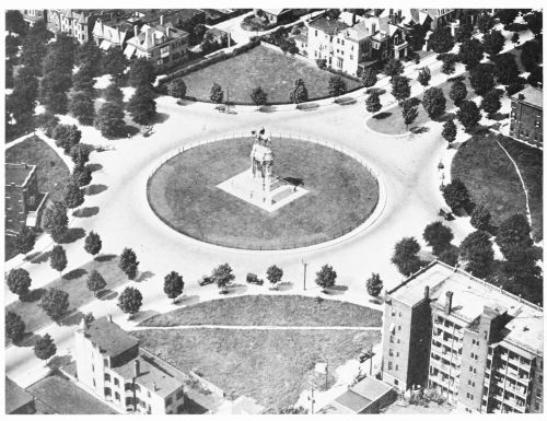
Fig. 5—Monument Avenue, Richmond, Va., and the statue of Robert E. Lee. An oblique photograph illustrating the use of aerial photography in landscape gardening and street planning.
Engineering Projects Covering Large Areas
Where the project covers large areas, the “mosaic,” or group of matched photographs, can be used in the study of problems of construction or improvement. Figure 13, a mosaic of the Anacostia flats, the site of improvements under way in the District
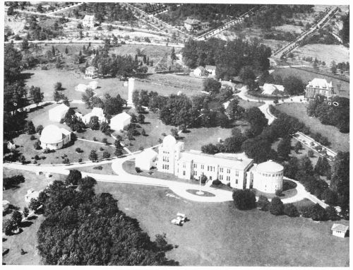
Fig. 6—The United States Naval Observatory and grounds, Washington, D.C., as seen from an airplane at a height of a few hundred feet above the ground, showing an unusually attractive arrangement of shrubbery and trees.
of Columbia, shows the Anacostia marshes as they appeared in the autumn of 1920, after the changes effected since 1915, as can be seen by comparison with Figure 14, the topographic map of the same area. To the right is the terraced slope rising to a height of about 150 feet above the river—an elevation so low that the air photograph does not properly reproduce it. Near the foot of the principal terrace lie the tracks of the Pennsylvania Railroad, on which can be seen Benning, Deanewood, and Kenilworth. Between the railroad and the Anacostia River are the Benning race track and the swampy lowland and tidal marshes of the Anacostia flats. The river and the marshland on either side of it from the Pennsylvania Avenue Bridge to Benning Road have been modified by dredging, but north of
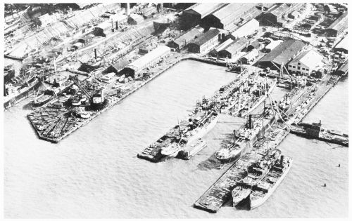
Fig. 7—Shipyards at Newport News, Va., showing docks and deep-water approaches, steamships, and drydocks, in one of which is a vessel for repairs.
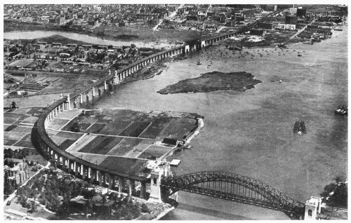
Fig. 8—The New York Connecting Railroad Bridge, which affords an all-rail passenger and freight route between Boston and Washington. The bridge, which was completed in 1917, starts on the mainland in the Port Morris section of southern Bronx Borough, New York City, seen in the background, then crosses Bronx Kill, Randalls Island, Little Hell Gate, Wards Island, and Hell Gate to reach the Long Island shore, seen in the extreme lower right corner, at Long Island City, Queens Borough. The tracks continue towards Washington by way of tunnels under the East River and the Hudson.
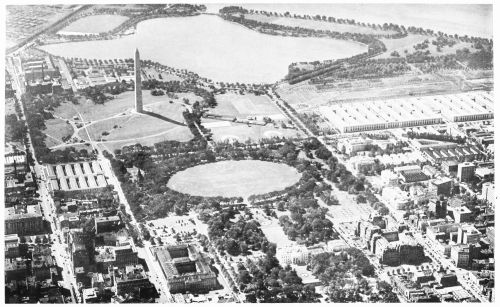
Fig. 9—A part of Washington, D.C., showing the White House, Treasury, State-War-Navy, and other public buildings in the foreground; the Ellipse, Washington Monument, and new War and Navy offices in the middle ground; and the Tidal Basin, Potomac Park, and the Potomac River in the distance. By no other means could so informative a glimpse be given of a spot of such wide interest. Every feature in the picture is more or less familiar to a large number of Americans, but their familiarity is with the individual features rather than with their situation and relation to one another as shown here.
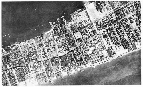
Fig. 10—Part of Rockaway Beach, Long Island, N.Y., showing city blocks, streets, and buildings covering the sand which a few years ago was barren and unoccupied. Scale, about 1: 6,700.
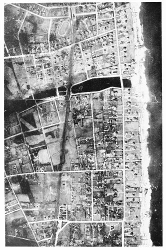
Fig. 11—Landscape gardening. An airplane view of a part of Long Branch, N.J., taken from a height of 10,000 feet, showing the beach and surf at the right, and the streets, mansions, driveways, and lawns in the body of the picture—an example of the development of a barrier beach of little value before the exploitation for summer homes. Scale, about 1: 15,000.
this road the surface appears in its natural state. In the mosaic are shown at the left the highlands west of the marshes, wooded in some places but cleared and improved in others. In the northern part can be seen land wooded north of the District line but cleared south of it. So comprehensive a view of the field of the project and of the progress to date should be of great service to the engineers and promoters.