Chapter II · FAMILIAR SCENES FROM A NEW ANGLE (Figs. 1, 3, and 4)
Reading edition
Pictures of well-known buildings are of wide appeal. In so far as they create an interest in the activities for which the buildings stand they are distinctly educative. Such widely known buildings as the National Capitol and the Library of Congress are used repeatedly for illustration. They are as welcome as the sight of a familiar face. Any unusual circumstance connected with them is seized upon as an excuse for republishing pictures of them. Views of them from a new angle are always in demand. Not only do air photographs offer a welcome novelty, but they have the added advantage of lifting the subject out of the clutter of surrounding buildings and making it really the central figure of the picture. It would be difficult to get a more impressive view of the National Capitol than that of Figure 1 or a more attractive glimpse of the Naval Academy at Annapolis than that of Figure 4. The objects of chief interest occupy the center of view without distracting obstructions. In the former, the imposing structure of the Capitol building appears in a pleasing setting of minor details. The proximity of the Senate Office Building and the Library of Congress is at once apparent, and the radiating systems of the avenues of approach. Strangers may have wondered as to the nature of the environs of the Capitol. The tree-lined streets and the apartment houses seen in the picture answer the question. In the view of the Naval Academy the buildings occupy the center of the scene, with the beautiful dome of the memorial to John Paul Jones, the first great American naval fighter, prominently in view. Spa Creek in the foreground, a part of the capital city of Maryland at the left, and the Severn River, with its low wooded banks, stretching away
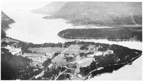
Fig. 3—West Point, N. Y., and the Hudson River. An air view of the United States Military Academy and the gorge of the Hudson. The picture shows the commanding view of the river to be had from the point of land 180 feet above the river on which the Military Academy is located and shows the wisdom of the choice of this spot as one of the chain of redoubts by which the river was fortified during the Revolution.
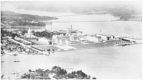
Fig. 4—The Naval Academy at Annapolis, Md. Oblique view from an airplane from a position over Eastport in a general northwesterly direction. The water in the foreground is Spa Creek. The Severn River, spanned by the county bridge and the Baltimore and Annapolis Railroad bridge, stretches away to the left. The buildings in the middle of the picture are those of the Naval Academy. The domed mausoleum built in honor of John Paul Jones, which serves as his final resting place, appears at the left. Still farther to the left lies Maryland’s capital city. Of interest is a comparison of the low-lying and stream-cut banks of the drowned valley now occupied by the Severn River with the mountains through which the Hudson River has cut its gorge at West Point (see Fig. 3).
in the distance, spanned by the county bridge and the Baltimore and Annapolis Railroad bridge, form an interesting setting and show, without detracting from the importance of the academy itself, its advantageous location with regard to the city and the water approaches.