FIRST POINTED PERIOD. (continued 4)
Reading edition
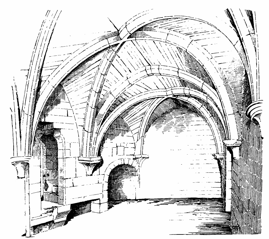
Fig. 644.—Culross Abbey. Chamber on West Side of Cloister.
About a quarter of a mile north from the abbey there exist the remains of a lodge, with indications of an arched “pend.” The lodge is still in use, but quite modernised. This archway was probably an entrance to the grounds of the abbey.
The most remarkable feature of the edifice is the tower which divides the east church from the west. From its architecture we may at once conclude that the upper portion is a structure of late date, probably of the sixteenth century. The interior doorway (see Fig. 636) is clearly of about that period, but some of the features of the lower story seem, as above mentioned, to point to that part being of an earlier time, probably thirteenth century.
The puzzle here is to understand how this solid tower should have been set down in the centre of the church, thus completely cutting off the western portion from the eastern, and forming two separate churches. Two possible solutions of this difficulty present themselves.
1. The two churches may have been intentionally kept separate, the western portion being the parish church and the eastern that of the monks. Such an arrangement is unusual in Scotland, but Mr. Freeman has described several churches in England where one portion belonged to the parishioners and the remainder to the monks. The chief difficulty connected with this theory is that the parish of Culross (as above mentioned) was provided with a separate parish church at a little distance away.[87]
2. The second supposition is that, in course of time, the monastery may have dwindled, and the buildings may have fallen into disrepair. The question would then arise whether it would not be better to diminish the size of the church by abandoning the western portion and erecting the tower where it stands. This might have occurred towards the close of the fifteenth century. But there are difficulties connected with this solution of the problem also. The tower shows the springing and jambs of windows on its west side, which appear to be of about the same date as itself, thus indicating the intention of continuing the structure westwards and restoring the old west church.
THE OLD PARISH CHURCH OF CULROSS, Perthshire.
A ruinous structure, situated about one mile north-west from the abbey. It is a plain oblong (Fig. 645), 71 feet long by 16 feet wide (inside), with walls about 3 feet thick, but parts of them have been recently rebuilt on the old foundations. It is thus impossible to say what the original arrangement of doors and windows may have been, only one small pointed window, which seems to be original, remaining next the south doorway. A north and south doorway face one another towards the west end, but these have evidently been inserted at a late date. Both doorways have straight lintels (Fig. 646), and these consist of ancient tombstones, carved with foliaged crosses and swords (Fig. 647).
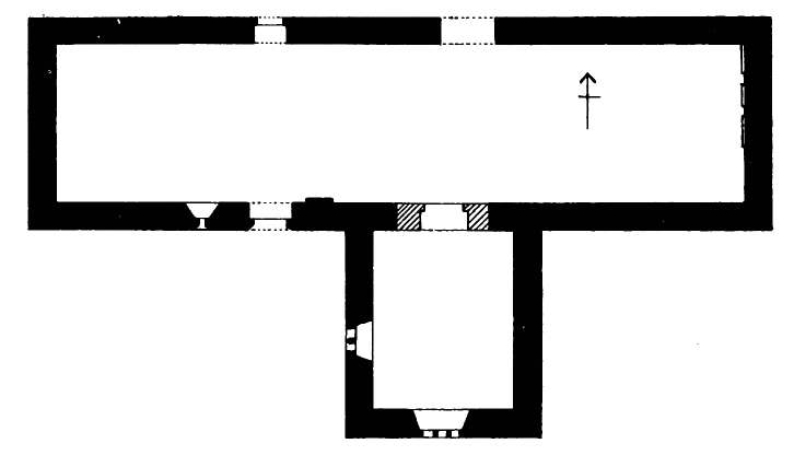
Fig. 645.—The Old Parish Church of Culross. Plan.
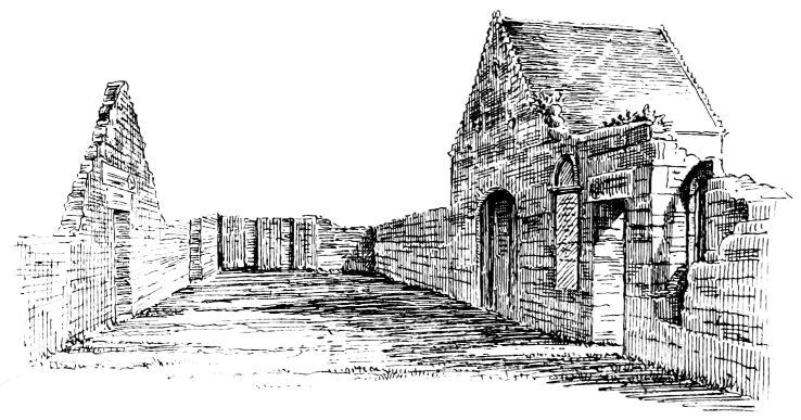
Fig. 646.—The Old Parish Church of Culross. Interior, looking East.
Numerous other recumbent tombstones are found in the church, and some have been placed against the east wall when it was rebuilt. A top stone containing the socket for a cross is preserved at the east end. The south doorway has probably had a porch.
This church had apparently fallen into decay before the Reformation, for in 1633 an Act was passed making the abbey the parish church, and stating that the abbey church had been used for preaching since the Reformation, and that the church called the “Parioche Kirk, where service is not nor has been since the memory of man, is altogether ruinous, decayed, and fallen down in certain parts.”
It is still surrounded with the old burying-ground, which contains some interesting monuments. A large tombhouse has been built, like a transept, on the south side of the church. It appears to be an erection of the seventeenth century.
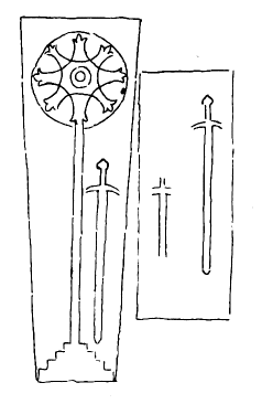
Fig. 647.
The Old Parish Church of Culross. Tombstones used as Door Lintels.
BEAULY PRIORY, Inverness-shire.
This monastery was pleasantly situated on the north side of the river Beauly, not far from the point where it falls into the sea at the head of the Beauly Frith, which forms the inner portion of the Moray Frith. The land is level and fertile, and the scenery on the river is very beautiful. The priory is about ten miles west from Inverness, and about one mile from Beauly Railway Station. It is believed to have been founded in 1230, and was thereafter endowed by Sir John Bisset of Lovat.[88] The priory was dedicated to St. John the Baptist, and was occupied by seven French monks of the Order of Valliscaulium. This was one of the strict orders established at the time of the revival of religion in the twelfth century. The mother house of the order was at Langres, in Burgundy. Of this order there were only three priories in Scotland: one at Pluscarden, in Morayshire; one at Ardchattan, in Argyle; and one at Beauly. The monks were austere in their lives, and formed a centre of devotion and enlightenment in the midst of these wild and uncivilised districts. The charter of the foundation was confirmed by Pope Gregory XI. in 1231. The priory was probably erected during the thirteenth century, but its records are few for a long period.
The Frasers succeeded the Bysets in the lands surrounding the priory, and Hugh Fraser, who was first Lord of Lovat, died in 1398. His son, Alexander, was a great benefactor of the priory, and is said to have erected a beautiful steeple of carved oak on the west gable, and put curious bells therein.
Hugh Fraser (about 1430-40) afforded means for building the north work of the priory and the chapel of the Holy Cross.
The church was soon after repaired at the expense of the superior, a natural son of Alexander of Kintail, who was there buried, A.D. 1479. His tomb is opposite that of his brother, Sir Kenneth Mackenzie of Kintail, with the date 1491. Sir Kenneth was the first of his family who was buried at Beauly, having married a daughter of Lord Lovat and obtained the Beauly property.
In 1530 Abbot Robert Reid of Kinloss received a gift of the Abbey of Beauly in commendam.[89] It is recorded by Ferrerius that many new buildings were erected and old ones repaired by this abbot. He is stated to have collected materials in 1537 and to have rebuilt the nave in 1540, and the structure bears evidence of his operations. He also restored the bell tower, which had been destroyed by lightning; but in 1541 that work was demolished, and the bells destroyed by a violent storm, which also did much damage throughout the country.
In 1544 Bishop Reid (being now promoted to the See of Orkney) removed the ruinous house of the prior, and erected a new and spacious house, with six vaults on the basement; but of this structure there is now no trace.
Robert Reid was succeeded, as commendator, by his nephew, Walter Reid, who was also his successor in the abbacy of Kinloss. The possessions of the Priory of Beauly were alienated, in 1571, by Walter, the new commendator, as were also those of Kinloss. The lands thus became the property of the Lovat family. On the forfeiture of Lord Lovat, in 1516, the abbey reverted to the Crown.
The priory consisted of the church, with a cloister to the south, which was, in all probability, surrounded by the usual monastic buildings; but the latter, including the spacious prior’s house erected by Bishop Reid, have almost entirely disappeared. The walls of the church (Fig. 648) survive, but even these have been sadly abused. The buttresses have all been torn down, apparently for the sake of the freestone dressings, and the tracery of the windows has been greatly demolished.
The church consists of a single long aisleless chamber, a little over 150 feet in length by 24 feet 6 inches in width (within the walls). The eastern part formed the presbytery and choir, and the western part the nave, but there is no architectural feature to mark the divisions. About the place where a transept might have been there are two projections, which break the long line of the exterior. These projecting chambers or chapels are shut off from the main church by solid walls containing doorways and monuments. They thus formed separate chapels, or one of them may have been a sacristy. The architecture of the choir and presbytery (Fig. 649) is remarkably fine, and is of first pointed character. Although in this remote region its date may probably be later than usual, it can scarcely be, as Mr. Muir suggests, so late as the beginning of the fourteenth century.
The details are very simple, the jambs and arches having plain splays. The caps of the shafts adjoining the windows in the interior are moulded and have round abaci, but the shafts, which were detached in the early manner, have disappeared. The arrangement of the arches is different on the two opposite sides. The east window was very wide, and, doubtless, was filled with tracery, which had several mullions. This may have been a later addition; the tracery has entirely disappeared. The lower portions of the buttresses of the choir have been rebuilt within recent years, probably in consequence of an agreement entered into between Lord Lovat and the Crown, whereby the former undertakes to keep the buildings in good repair.
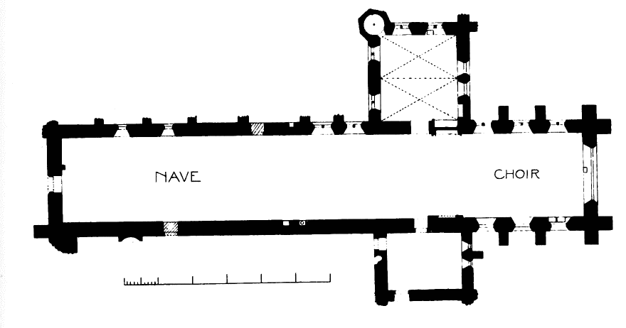
Fig. 648.—Beauly Priory. Plan.
The most striking feature of the nave is the row of triangular pointed windows running along the south side (Fig. 650). These have evidently been curtailed in height in the design, so as to admit of the roof of the cloister walk resting against the south wall of the church, the corbels for its support being yet visible. The west end of this wall has evidently had domestic buildings of a high and substantial character erected against it, some fragments of which still remain, showing a fireplace, portions of a staircase, &c. (see Fig. 650).
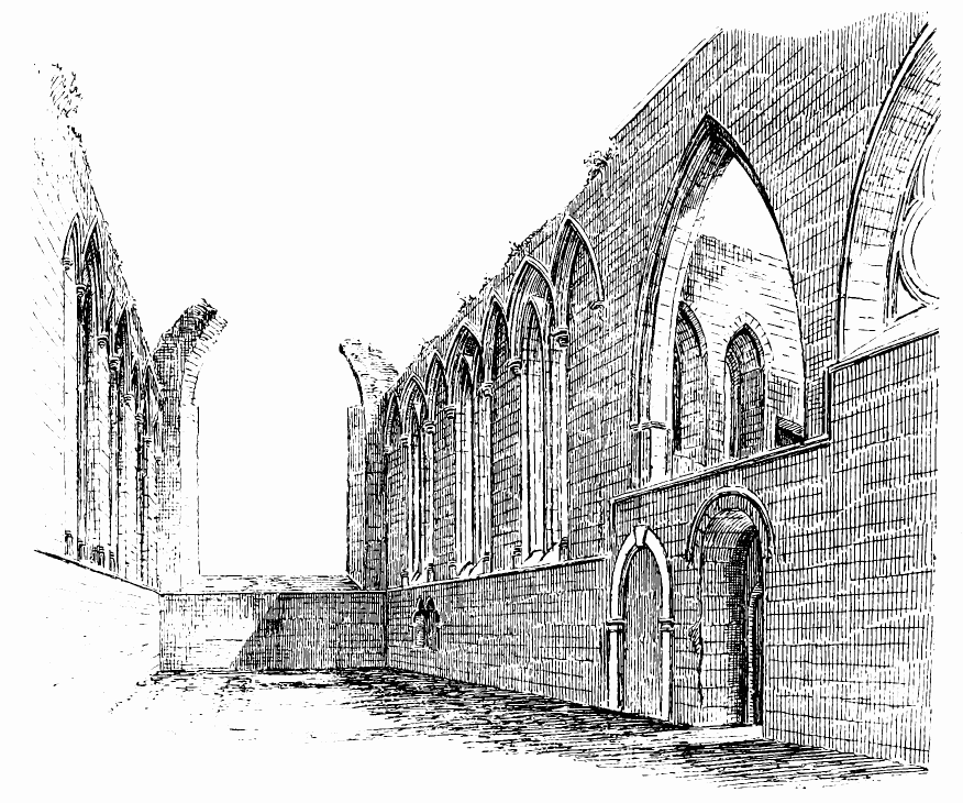
Fig. 649.—Beauly Priory. Choir, looking East.
The western façade bears the marks of Bishop Reid’s workmanship, and is no doubt part of what is meant to be attributed to him when it is said that he rebuilt the nave. The triangular south windows above mentioned, and the two light pointed windows on the south side of the nave, are undoubtedly much earlier than his date, which was about 1540-50, but other parts of the walls of the nave may have been re-erected by him when he restored the west end. The latter (see Fig. 650) is beyond doubt his work. The doorway in the centre, the arch of which is semicircular, contains the monogram I.H.S. on one of the label terminations, while the other drip stone shows two hands and two feet, with a heart in the centre (Fig. 651), emblems of the Passion. The arch of the doorway is round; but this, as we have seen elsewhere, is a common feature in Scottish work of all dates, and occurs especially often in late work.
The upper part of the west wall contains three pointed lancet windows, and is an example of the revival of early features in late work. Some of the windows in the side walls are of similar form, and are probably of the same date. The sill of the central window in the west end is kept high, so as to admit of a shallow ogee-headed niche for a figure over the entrance door. The figure may have represented the Baptist, but the niche is now empty. On a panel on the sill are Bishop Reid’s initials, R. R., and his arms, a stag’s head (see Fig. 651).
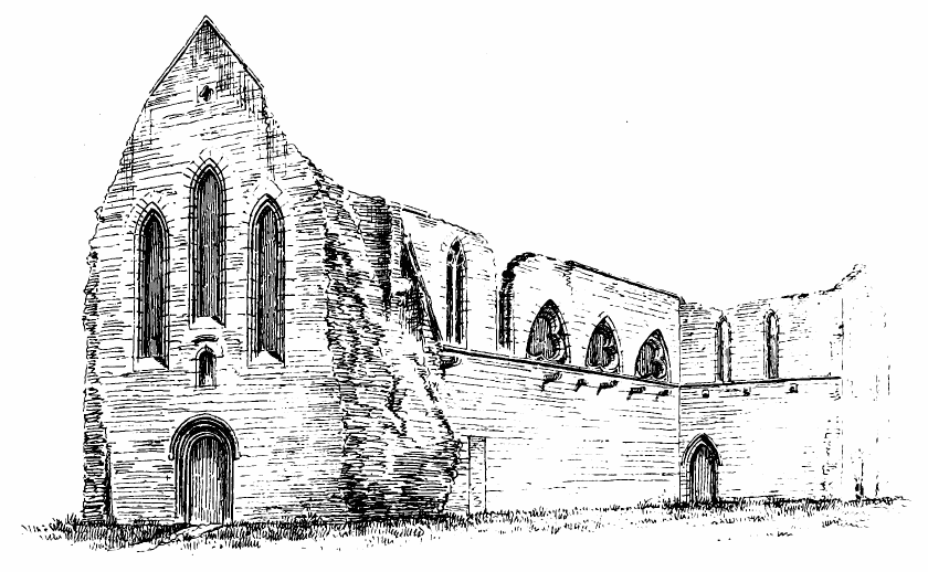
Fig. 650.—Beauly Priory. Nave from South-West.
The part of the church which projects to the north measures 25 feet by 22 feet 6 inches internally. It has been vaulted in two bays, the vaults springing from corbels in the walls; part of the vault still remains. This chamber is said to have been the sacristy. It has a turret at the north-west angle, containing a stair to the roof. In a recess in the wall which divides this chapel from the choir lies the tomb (abovementioned) of Sir Kenneth Mackenzie of Kintail.
We have seen that the “north work” was erected at the expense of Hugh Fraser (1430-40), and the style of this chapel corresponds with that date.
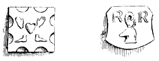
Fig. 651.—Beauly Priory.
Drip Stone and Panel.
The repairs carried out by Prior Alexander were probably the work required for the erection of the tomb of Sir Kenneth and his own tomb, which was in a recess in the choir on the opposite side of the wall from that of Sir Kenneth.
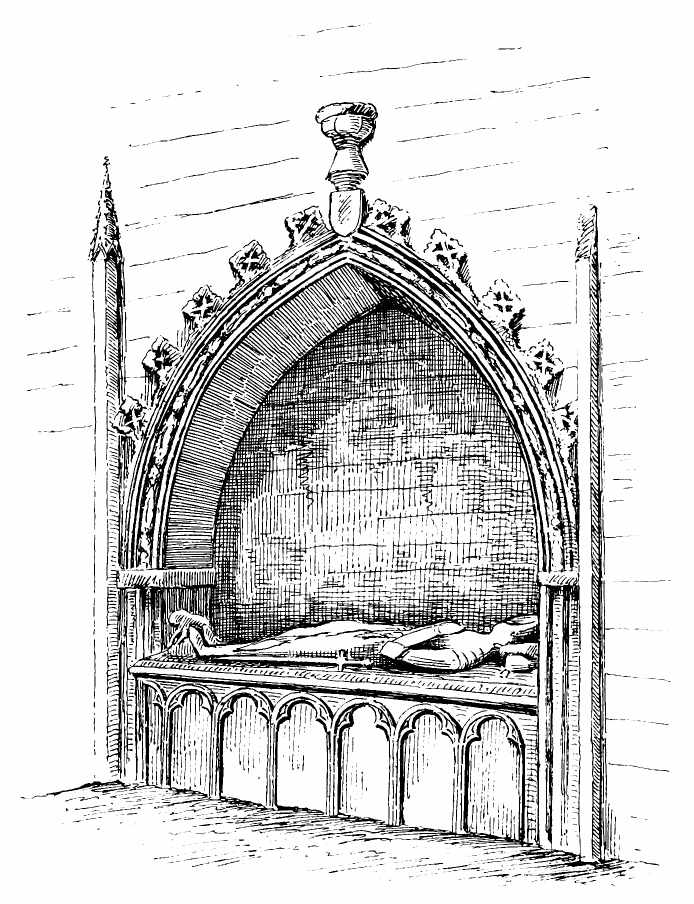
Fig. 652.—Beauly Priory. Tomb of Sir Kenneth Mackenzie.
The tomb of Sir Kenneth (Fig. 652) is a good specimen of the work of the period, and is very similar to other tombs of the same kind at Fortrose and Fearn. The recumbent figure, clad in full armour, rests on an arcaded tomb or pedestal, and the recess, which is covered with a pointed canopy, is enriched with a crocketed label and pinnacle bearing a shield, and the whole tomb is flanked by two thin buttresses. On the sill is engraved the following inscription:—“Hic Jacet Kanyens M. Kynych d’us de Kyntayl. q. obiit dii Februarii A. Di M.CCCC.LXXXXI.”
The chamber to the south of the choir has also contained monuments, but they are now destroyed. It measures 22 feet by 17 feet internally, and seems to have been connected by a door with the conventual buildings to the south. It has contained two stories, the upper story forming a gallery, connected with the church by a wide arch (see Fig. 649).
The choir contains a double piscina, near the east end, in a good first pointed style.
Under the triangular windows in the south wall of the nave are a piscina and ambry. These mark the position of an altar, which may have been erected at the rood screen, which probably separated the nave from the choir at this point, thus dividing the portion of the church open to the parishioners from that reserved for the clerics. Opposite this piscina there is a door (now built up) in the north wall, and near it, on the outside, there is another piscina. This may possibly mark the position of another chapel, which may have been that of the Holy Cross above, said to have been erected by Hugh Fraser in the fifteenth century.
NEWBATTLE OR NEWBOTLE ABBEY,[90] Mid-Lothian.
Newbotle Abbey or, as it is now called (without the name having any special meaning), Newbattle Abbey is situated on the river Esk, about two miles south from Dalkeith. It was founded by David I. in the year 1140, for monks of the Cistercian order, who were brought to Newbotle (or new residence) from Melrose. The “leader of the colony” appears to have been Ralph, the first abbot, who obtained numerous gifts and privileges for the convent, and consecrated a “cemetery within the precinct of the monastery.” The second abbot, Alfred, who died in 1179, was also a great benefactor to the abbey. He brought to it many relics, which he enclosed in a silver chest. “He adorned the chapter house with handsome seats, and also erected proper stalls, with convenient desks or menologies of wood, in the cloisters on the side where the ‘collation’ or reading of the lives of the saints was held, for the use of the brethren during the reading of collation before compline at the washing of feet at Maunday.”[91]
During the time of the tenth abbot, Constantine, the church was dedicated by Andrew de Moravia, Bishop of Moray, in March 1233.
In the year 1241, Mary de Couci, queen of Alexander II., “looking to her time of peril, and impressed with the frail tenure of life, bequeathed her body to be buried in the church of Newbotle.”[92] This would seem to indicate that the fabric of the church, if not finished by this time, was far advanced. Mary de Couci survived for about thirty years, when her desire to be buried here was carried out; and Father Hay describes her tomb, apparently from the record of an eye-witness. “In the midst of the church was seen the tomb of the queen of King Alexander, of marble, supported on six lions of marble. A human figure was placed reclining on the tomb, surrounded with an iron grating.”[93]
In 1275 Waldeve, the seventeenth abbot, “going the way of all flesh, with blessed end, departed to the Lord, leaving his house in full peace and excellent condition.”
Gervase, the nineteenth abbot, who demitted office in 1323, settled for ever on the infirmary of the abbey an annual rent of three merks, “to be expended for the uses of the sick and the recreation of the feeble.”[94] These few notices seem to show that about the middle of the fourteenth century the abbey was in a fairly complete state. It possessed great estates in the counties of the Lothians, Lanark, Peebles, and Stirling. Father Hay writes that, about this time, he “finds, from the books of receipts and expenses, the annual income of the monastery could maintain eighty monks and seventy lay brethren, with the corresponding establishment.”[95]
But evil days were at hand. In 1385, during the expedition of Richard II., “the English,” writes Father Hay, “burnt the monastery of Newbotle; and, at the same time, several of the granges and farms of the monastery were destroyed, and the others were deserted, while the lands were left untilled. The towers or peles, built by the monastery for protection against English marauders, fared in the same way. Some of the monks were carried away prisoners; others fled to other monasteries. The few who remained in the abbey, having scarce sufficient food, were compelled, by great distress, to sell twenty-nine excellent chalices, nine crosses of exquisite workmanship, and other sacred ornaments, with their silver household plate. At that time the greater part of the abbey tower was ruined by the falling of the cross.” These events happened during the time of Hugh, the twenty-third abbot.
The work of restoration was, doubtless, gone on with as soon as convenient; and, in 1390, Sir James Douglas of Dalkeith, by his will, gave his body to be buried in the monastery of St. Mary of Newbotle. “At the same time he bequeathed to the abbey a ‘nowche,’ or jewel of St. John, worth 40 merks, or its value, and, in addition, £23, 6s. 8d. for the building of the church and wages of the masons employed upon it. For the service of the monks’ refectory he gave twelve silver dishes, weighing eighteen pounds, six shillings sterling, enjoining his heirs to see that they should not be abstracted from the use of the refectory or sold.”[96] Two years later Sir James, in another will, bequeaths similar sums to the abbey, without appropriating a part to the building or to the payment of workmen, which seems to show, as Mr. Innes remarks, that the rebuilding of the abbey church had been completed in the meantime.
In 1419 Edward of Crechton paid a sum for the restoring and building of the monastery.
In the Hertford expedition of 1544, “upon the 15th day of May the horsmen raid to Newbottill and brynt it.”[97] As is remarked by Mr. Innes,[98] this was, perhaps, but a partial destruction, as, three years afterwards, Mary of Lorraine held at Newbotle a great convention of the lords of her party, preparatory to declaring war with England.
The last so-called abbot was Mark Ker. He is styled Commendator of Newbotle in 1560; and the lordship of Newbotle, being conferred on his son, has remained with their descendants to the present day.
Such is the scanty history of this great abbey, so far as relates to the structure and ornaments; but of the former almost nothing remains above ground except part of the monastic buildings on the east side of the cloisters.
The abbey, including the church, appears to have been almost completely demolished shortly after the Reformation, the only parts of the monastic buildings allowed to remain being the fratry and portions of the chapter house, which were incorporated with the mansion house, and of the former of which a view has already been given.[99]
The accompanying Plan (Fig. 653) has been prepared by Mr. John Ramsay, the resident Clerk of Works to the Marquis of Lothian, showing the result of considerable excavations recently carried out at the building, together with some details which have been discovered. The Plan shows that the buildings extended about 400 feet from north to south by about 270 feet from east to west, and that the monastery was of the usual plan.
The recent excavations deal chiefly with the foundations of the abbey and church, although explorations within the mansion have also brought to light some old work hitherto concealed from view. The first discovery of the existence of buried portions of the abbey was made in 1878, when some works were in progress; and again, in 1892,
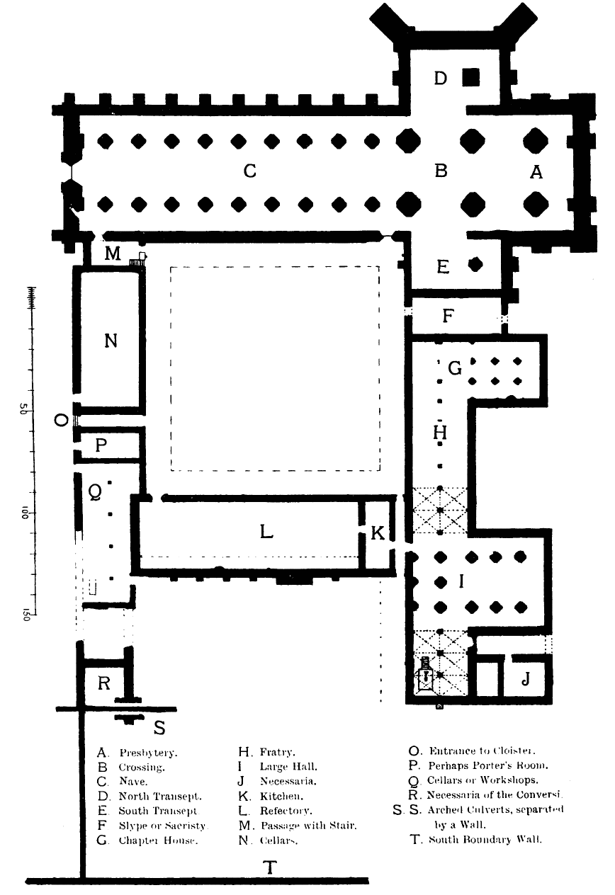
A. Presbytery. B. Crossing. C. Nave. D. North Transept. E. South Transept. F. Slype or Sacristy. G. Chapter House. H. Fratry. I. Large Hall. J. Necessaria. K. Kitchen. L. Refectory. M. Passage with Stair. N. Cellars. O. Entrance to Cloister. P. Perhaps Porter’s Room. Q. Cellars or Workshops. R. Necessaria of the Conversi. S. S. Arched Culverts, separated by a Wall. T. South Boundary Wall.
Fig. 653.—Newbattle Abbey. Plan.
when digging was going on connected with the planting of trees, some further remains were found. But in 1893-4 a systematic search was made, both above and below ground, which enabled an almost complete Plan of the abbey to be accurately measured and laid down.[100]
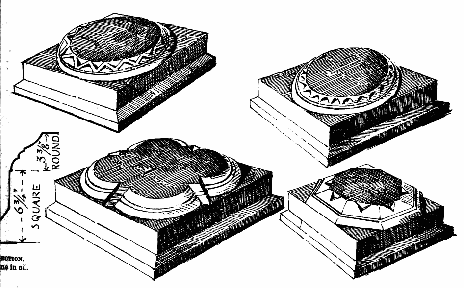
Fig. 654.—Newbattle Abbey. Bases in West Side of Cloister (at Q).
The total length of the abbey church, within the walls, was 239 feet 3 inches, and on the exterior 253 feet 3 inches; while the interior width was 57 feet 1 inch, and the exterior width (excluding the buttresses) was 66 feet 7 inches. The nave, which contained ten bays, had a length of 161 feet 6 inches, and its central aisle a width of 31 feet, while the side aisles were 13 feet. The choir and presbytery comprised one bay and a-half, and had two large piers, each 10 feet in diameter. The crossing had four similar large piers, and measured 41 feet 9 inches over the piers. The piers supported a tower over the crossing. The transept was 117 feet 6 inches in length from north to south, and had an eastern aisle, making the width 45 feet. The north transept had enormous angle buttresses and a square pier. The large piers and flat angle buttresses of the choir indicate early work, probably Norman.
The great angle buttresses at the north transepts belong, doubtless, to a late period. The Plan clearly shows that they have been added to existing flat buttresses, in the same manner as was done at the east wall of St. Andrews Cathedral. Unfortunately, no details have been discovered to enable the date to be more definitely fixed.
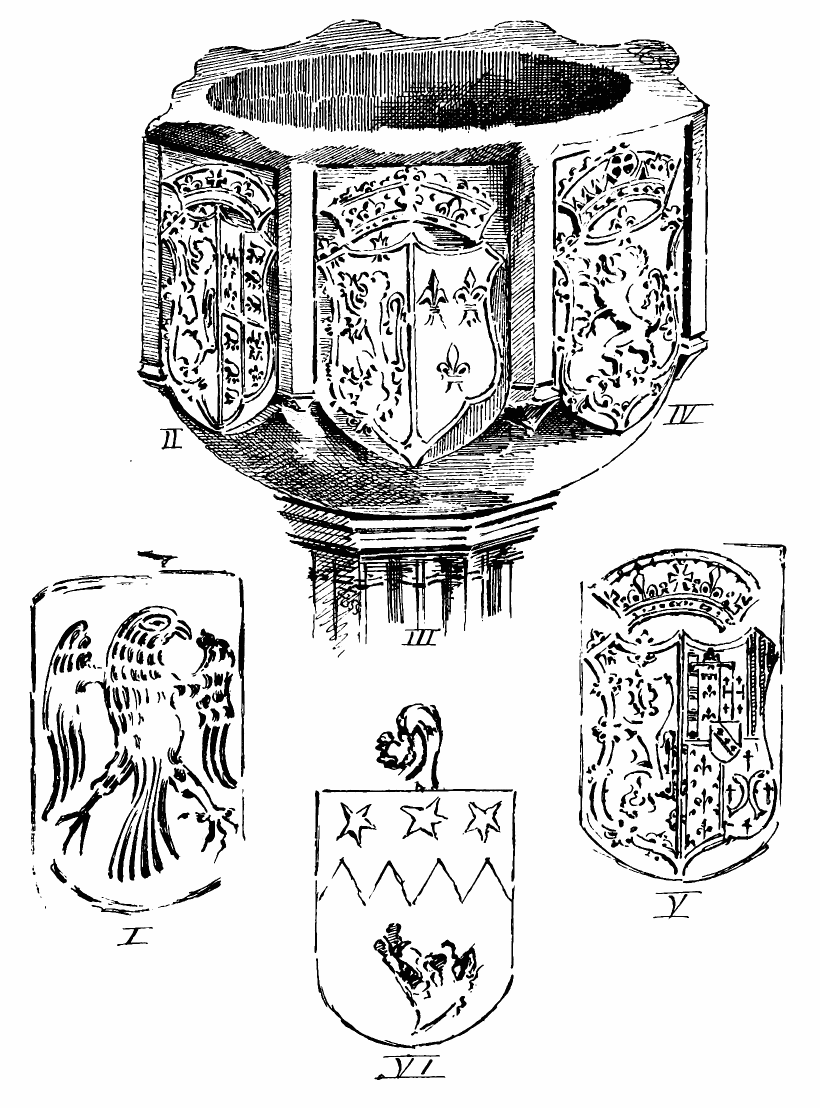
Fig. 655.—Newbattle Abbey. Font.
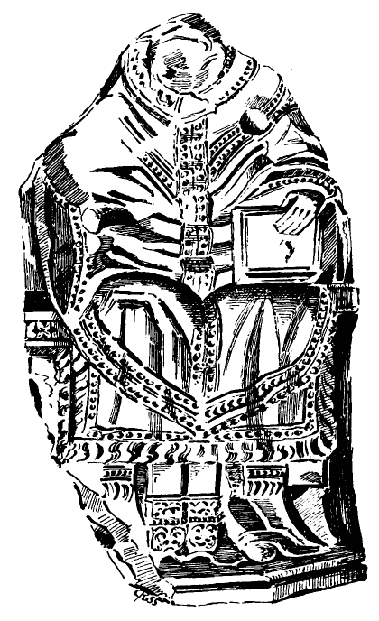
Fig. 656.—Newbattle Abbey. Seated Figure of Ecclesiastic.
The east side of the cloister, which is included in the modern mansion, extends southwards from the church for a distance of about 200 feet. Adjoining the transept has been the slype or sacristy; then comes the chapter house, of which only the bases of a double row of pillars remain. It was about 35 feet long by 27 feet wide, and projected towards the east; but the east end, being under the mansion, cannot be explored. The buildings adjoining to the south are well preserved on the ground floor. They are erroneously designated the crypts, as they are entirely above ground. The long range, with central pillars, was the fratry, beyond which was a large hall. On the south side of the cloister there was a passage and a well-preserved kitchen, with a large fireplace, measuring 12 feet 6 inches by 6 feet, and having still traces of smoke. Adjoining it, to the west, are the foundations of the refectory, 106 feet long by 33 feet 6 inches wide. It will be observed that, as usual in Scotland, the refectory is parallel with the church. On the west side of the cloister the foundations of several buildings have been laid bare. Next the nave there has been a passage containing a staircase to the dormitory of the conversi; then came a large apartment, 67 feet long by 28 feet 6 inches wide; then the entrance passage to the cloister, 6 feet 2 inches wide, with a doorway 4 feet 9 inches wide. To the south of this is another large apartment, 68 feet long by 23 feet 9 inches wide, having foundations of a central row of pillars, the bases of which are all different (Fig. 654). Still farther south are found remains of a large arched conduit or drain, 2 feet 6 inches wide, and the same height.
In the vaulted fratry there stands an old font (Fig. 655), which was found at Mavisbank House, some miles distant, about the year 1873, by workmen when digging for foundations of proposed new buildings. On the supposition that it contained the arms of Abbot Hasmall, and therefore belonged to Newbattle, it was brought here. It is interesting as being evidently intended, from the coats of arms with which it is adorned, to be a memorial of the royal family during the first half of the sixteenth century. The arms it contains are:—
1st Shield.—Arms of Ramsay.
2nd Shield.—Arms of Margaret of England (daughter of Henry VII.), wife of James IV.
3rd Shield.—Arms of Magdalene of France (daughter of Francis I.), first wife of James V.
4th Shield.—Arms of Scotland (James V.)
5th Shield.—Arms of Marie of Lorraine (daughter of Claude, Duke of Guise), second wife of James V.
6th Shield.—Supposed to be the arms of James Hasmall, Abbot of Newbotle (1542-1554).[101]
7th and 8th Shields.—Blank.
Only the bowl of the font is old. It is octagonal, and measures about 2 feet 6½ inches in width and 12½ inches across each face. The height of the bowl is 1 foot 7½ inches, and the depth 13½ inches, with a square hole at bottom.
There is also preserved at Newbattle the seated figure of an ecclesiastic, holding a book on his knee (Fig. 656). It is probably a work of the fourteenth or fifteenth century, as in the earlier years of Cistercian rule figure representations were prohibited; and the little rosette ornament seen on the sedilia indicates that period. The head is unfortunately broken, but the figure otherwise is beautifully preserved. The total
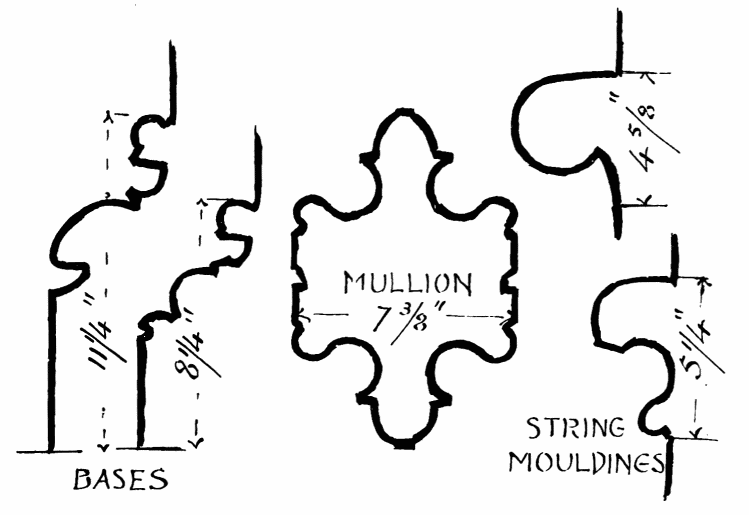
Fig. 657.—Newbattle Abbey. Details of Mouldings.
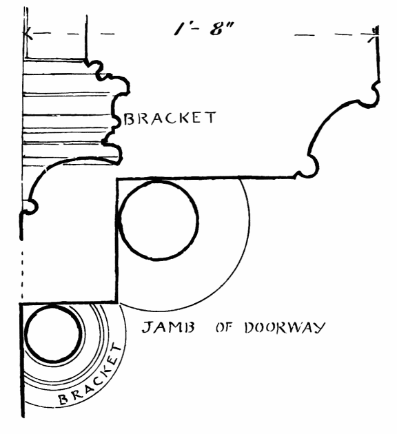
Fig. 658.—Newbattle Abbey. Details of Doorway, &c.
height of the fragment is about 27¼ inches, and the breadth about 15 inches, with a relief of about 5 inches.
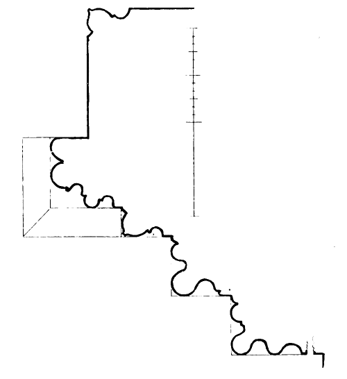
Fig. 659.—Newbattle Abbey. Mouldings of Doorway.
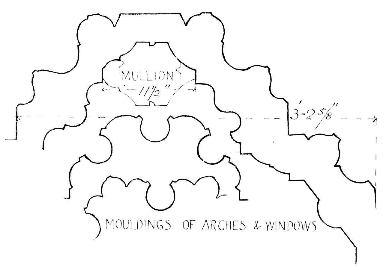
Fig. 660.—Newbattle Abbey. Details of Mouldings.
A number of stones containing mouldings have been found, some of the sections of which are shown. Some of the mouldings (as in Figs. 657, 658, and 659) are early, while the other mouldings (as in Figs. 660, 661, and 662) are for the most part late. It is not known to what parts of the
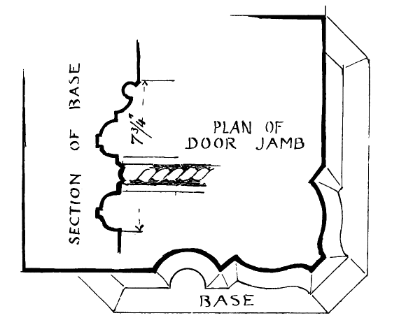
Fig. 661.—Newbattle Abbey. Details of Mouldings.
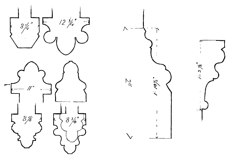
Fig. 662.—Newbattle Abbey. Vaulting Ribs. Fig. 663.—Newbattle Abbey. Cap and Base of Doorway.
building any of these details belonged, except in the case of Fig. 659, which is from the doorway at the west end of the refectory. The door entered from the western cloister walk, and is partly in situ. Fig. 663 represents a cap and base supposed to belong to the nave arcade, from their having been found in the nave.
Fig. 660 gives a series of arch mouldings, one of them being a window, with its mullion. The door jamb, with its base mouldings (Fig. 661), is probably a fifteenth or sixteenth century piece of work.
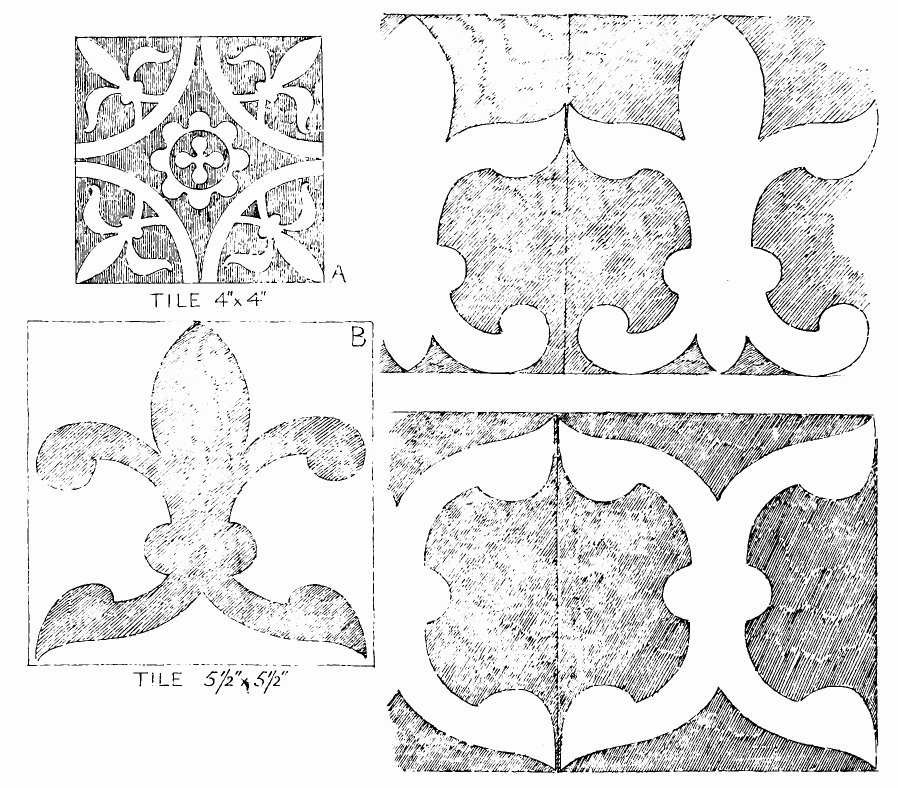
Fig. 664.—Newbattle Abbey. Details of Tiles. A. An Olive-Green Ground, White Pattern. B. A Red Pattern on a White Ground. The different colours are done in the surface glazing. It is put on about ⅛ inch thick, and the thickness of the tiles from 1¼ to 1½ inch. Fig. 665.—Newbattle Abbey. Details of Tiles. Ground Dark Green. Yellow Pattern, on a cut out Tile.
Fig. 662 shows a series of vaulting ribs, the two upper ones being of a somewhat early date, while the others are later in character.
Many tiles have been found in the ruins, which are now preserved in the house; and a few of them are illustrated. In Fig. 664 we have two square tiles, the lesser one having an olive-green ground with a white pattern; the larger one is a red pattern on a white ground. Those shown on Figs. 665 and 666 are shaped tiles, cut out by hand to the actual form of the figure, so that each separate tile is of one colour—in Fig. 665 it is a dark green ground with a yellow figure, and on Fig. 666 a black and brown ground with a white figure.
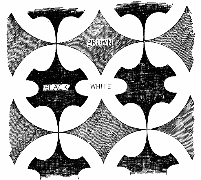
Fig. 666.—Newbattle Abbey. Details of Tiles.
LISMORE CATHEDRAL, Argyleshire.
The Island of Lismore lies near the south end of Loch Linnhe, and at a short distance from the mainland of Argyleshire. In 1236 the See of the Bishopric of Argyle was transferred from Mackairn, on the south side of Loch Etive, to Lismore, where a Columban monastery had been founded by St. Moluoc at an early period.
The cathedral was probably erected soon after the transference of the see in the thirteenth century. It is said to have been a structure 137 feet in length by 29⅓ feet in width. Of this pile there now only survives a single quadrilateral chamber, without aisles, used as the parish church, and measuring internally 51 feet in length by 23 feet 6 inches in width (Fig. 667). It has four buttresses of simple form against the south wall, and two at each of the north and south angles of the east wall. The walls and buttresses are entirely covered with rough casting. There is a doorway near the centre of the south wall (Fig. 668) which has had a nook shaft on each side, and a round arched head with a water table, but its details are destroyed. In the interior the arched head is segmental, and the label has bold first pointed terminals (Fig. 669). There has also been a sharply pointed doorway in the north wall (Fig. 670)—now built up—which retains in the interior a label moulding with head terminations, one being the head of a bishop.
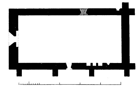
Fig. 667.—Lismore Cathedral. Plan.
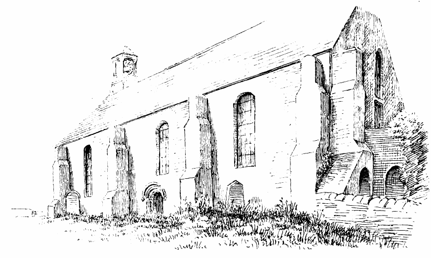
Fig. 668.—Lismore Cathedral. View from South-East.
In the south wall, and in the usual position near the east end, there are remains of a triple sedilia, much damaged, but having shafts between the seats, with moulded caps (Fig. 671). There is also a piscina in a pointed recess, having a trefoil headed niche in the wall behind, all much damaged (see Fig. 671).
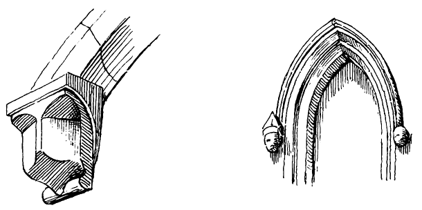
Fig. 669.—Lismore Cathedral. Interior Terminal of South Doorway. Fig. 670.—Lismore Cathedral. North Doorway.
In the exterior of the north wall, and near the buttress at the east end, there has been an ambry. This ambry, together with the absence of buttresses on the north side, seems to indicate that there was a building on that side, probably in the form of an aisle, connected with the cathedral. The eastmost portion was probably the sacristy, which would enter by the north doorway. On the south side of the church the wall, with its buttresses (see Fig. 668), has evidently been the exterior of the church. It contains a segmental headed modern window in each bay. The south buttress of the east wall is widened at the lower part, and contains a round arched recess, in which there has probably been a monument. The east end has been greatly altered, and has had a staircase block built against it, and a gallery door and high window inserted.
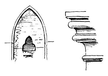
Fig. 671.—Lismore Cathedral.
Piscina and Cap of Shafts of Sedilia.
The western wall, with its doorway, which has plain sloping jambs all covered with rough-cast, is, doubtless, a comparatively recent construction, built when the choir was converted into the parish church and reroofed in 1749.
There are traces of old buildings to the west, which are now used as private burial-grounds, but it is impossible to say what purpose they formerly served.
ST. KENTIGERN’S, Lanark, Lanarkshire.
The Parish Church of Lanark existed in the twelfth century, and was conveyed, with its possessions, to the Abbey of Dryburgh by David I. This conveyance is frequently confirmed in subsequent deeds.
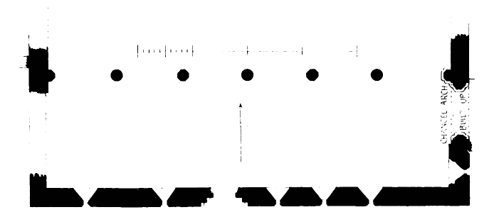
Fig. 672.—St. Kentigern’s. Plan.
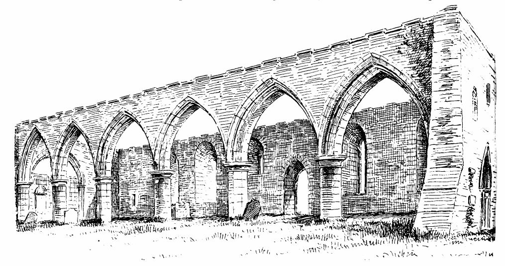
Fig. 673.—St. Kentigern’s. View from North-West.
The church, from time to time, received numerous gifts of lands and houses from the burgesses and the neighbouring proprietors. Amongst other endowments, a chaplaincy was founded in the beginning of the fifteenth century by John Simpson, burgess of the town. The income of the church and its lands was drawn by the monks of Dryburgh, and the cure was served by a vicar and curates. At the Reformation the lands went with the Abbey of Dryburgh, which was erected into a temporal barony.[102]
The Church of St. Kentigern was used for service long after the Reformation, and was only abandoned when a new church was erected in the middle of the town in 1777.
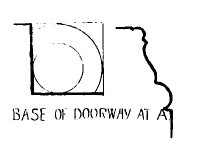
BASE OF DOORWAY AT A
Fig. 674.—St. Kentigern’s. Plan and Base of Doorway Shaft.
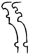
Fig. 675. St. Kentigern’s. Caps of Piers.
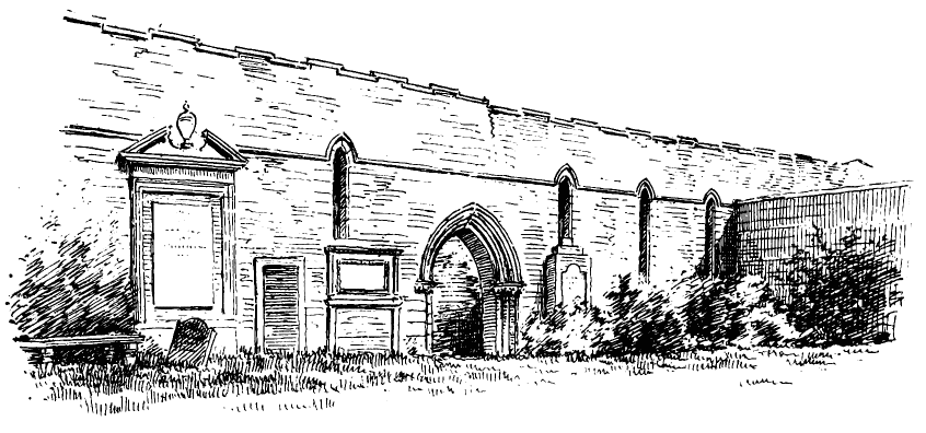
Fig. 676.—St. Kentigern’s. South Elevation.
St. Kentigern’s stands in the old burial-ground, about one-quarter of a mile south-east from the town. It has been of an unusual arrangement of plan (Fig. 672), consisting of a double chamber, divided by a row of pillars and arches down the centre, each division possibly, and one division certainly, having a chancel at the east end. The northern division has almost entirely disappeared, but the central row of pillars and arches (Fig. 673) and the walls of the southern division are still fairly preserved. At the point A on Plan is the base of a doorway shaft (Fig. 674), which was discovered some years ago by excavation. This possibly represents the north doorway of the church. If so, the north division was about 2 feet wider than the south division. The south division is 74 feet in length by 20 feet in width internally. The five pillars are alternately round and octagonal, and the two responds are half octagons. The caps (Fig. 675) are of varied and good design, and the arches have a double splay on each side.
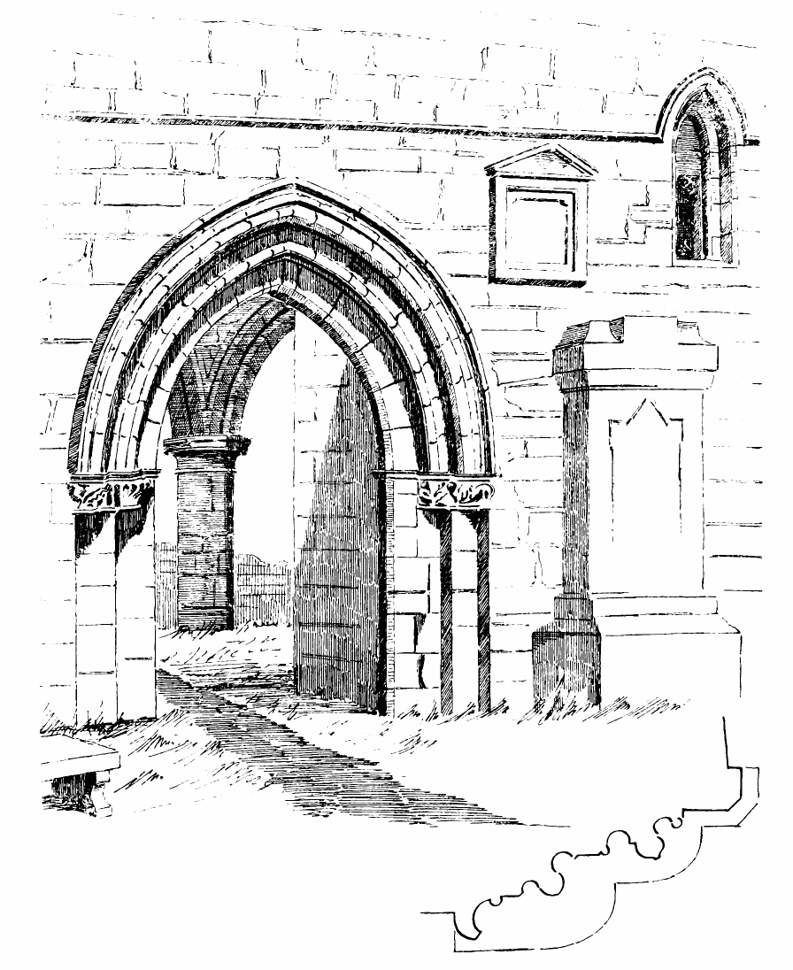
Fig. 677.—St. Kentigern’s. South Doorway.
The south wall (Fig. 676) contains the relics of a fine first pointed doorway, and five narrow lancet windows with wide splayed reveals inside. The doorway has had two nook shafts on each side, with markedly first pointed foliage in the caps (Fig. 677), and the pointed arch has bold and characteristic mouldings (Fig. 678). The west wall (see Fig. 673) has been much ruined, and is now restored. At the east end there is a chancel arch fully 8 feet in width. The responds which support it are half octagons, and the arch has a double splay on each side. There are traces of small nail-head ornaments on the caps. All the details point to the work being of the first pointed period. The chancel is entirely gone, but the marks on the wall show that it has been about twelve feet in width. There is a small lancet window, with wide internal splay, in the east wall to the south of the chancel arch, and the latter is placed close to the central row of pillars. This arrangement seems to have been adopted so as to bring the chancel as near the centre of the church as possible, perhaps with the view of enabling it to serve as the chancel for the whole church, as there may have been no chancel to the east of the northern division. But this point could only be ascertained by excavation. To the east of the northern division, where a chancel might have been, there has been erected (probably in the seventeenth century) a mausoleum or tombhouse for the family of the Lockharts of Lee. This rather seems to support the idea that there was no chancel in that position.
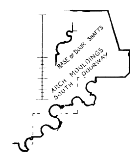
Fig. 678.—St. Kentigern’s. Arch Mouldings of South Doorway.
BURNTISLAND CHURCH, Fifeshire.
At Kirkton, a village lying a short way north of Burntisland, there stand, in an old churchyard, the remains of an ancient church, believed to have been dedicated to St. Adamnan or St. Serf. The church (Fig. 679) consists of a nave and chancel and remains of a south aisle. The nave measures 41 feet 9 inches in length by 20 feet 6 inches in width externally, and the chancel is 27 feet 6 inches long by 17 feet 9 inches wide externally. The chancel is architecturally distinguished from the nave being diminished by 14 inches in width on each side, and the chancel arch is pointed, with an opening 7 feet 8 inches wide, and consists of a single plain order springing from imposts having a simple splay (Fig. 680). The jambs of the opening are plain, and have a splayed base. The opening has been built up so as to enclose the chancel for a private burial-place. The chancel contains the usual priests’ door in the south wall, and two narrow pointed windows on the same side, greatly splayed to the interior. It is remarkable that there is no window in the east end, and the north wall is also blank.
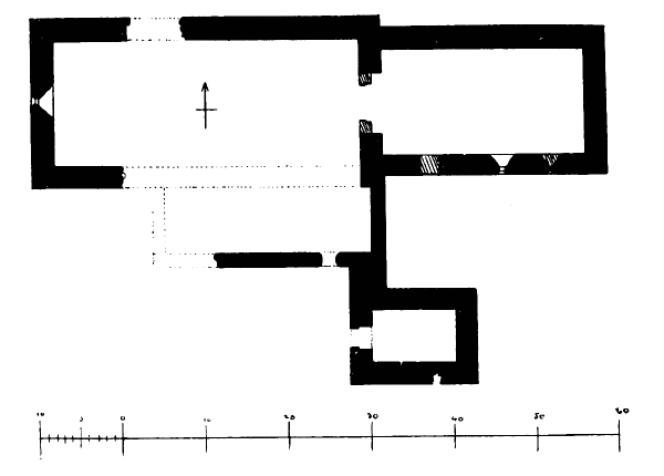
Fig. 679.—Burntisland Church. Plan.
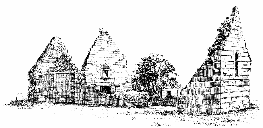
Fig. 680.—Burntisland Church. View from North-West.
The south wall of the nave has been removed, probably when a south aisle was added. Its place was, doubtless, at one time supplied by pillars and arches, but they are now gone. Part of the outer wall of the south aisle still remains. To the south of this there is a small building, which may have been a sacristy, or perhaps a tombhouse.
The north door to the nave is still partly preserved, and there was probably a south door opposite it. In the west end, which still exists (see Fig. 680), there is a simple pointed window, greatly splayed within.
The walls are built with freestone ashlar. All the features seem to indicate that the church was erected in the thirteenth century, although it has been surmised that it was rebuilt in the fifteenth century. The simplicity of the chancel arch and the absence of an east window are against that supposition.
PRESTONKIRK CHURCH, Haddingtonshire.
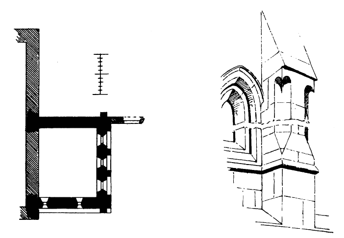
Fig 681.—Prestonkirk Church. Plan. Fig. 682.—Prestonkirk Church. Details of Buttress and Window.
This church, like several others in the eastern part of this county, is dedicated to St. Baldred of the Bass Rock.[103] It is situated within a mile of East Linton Railway Station. The church has originally been a first pointed edifice, but now there only survives a small eastern choir of that period, the main body of the church having been rebuilt. The choir (Fig. 681), which is now cut off from the church by a solid wall, is 15 feet long by 17 feet 6 inches wide internally. It has three tall lancet windows of equal height in the east end (Fig. 683), separated by first pointed buttresses of good form, as seen in the detailed sketch (Fig. 682). The south wall has two simple lancets with hood moulds, and on both sides there is a broad set-off below the windows. The north wall is plain, and without special features. The building is a pleasing fragment of first pointed work.
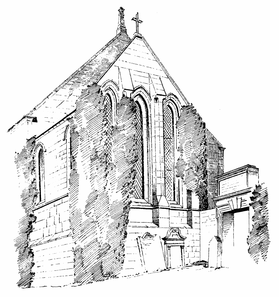
Fig. 683.—Prestonkirk Church. View from South-East.
COWIE CHURCH,[104] Kincardineshire.
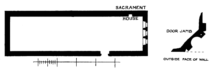
Fig. 684.—Cowie Church. Plan. Fig. 685.—Cowie Church. Moulding of Doorway.
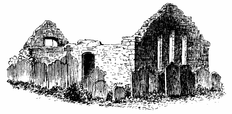
Fig. 686.—Cowie Church. View from South-East.
This ruined structure, is situated near the coast on the north side of Stonehaven Bay, about a mile from the town, and stands in an ancient churchyard still in use. This church is an example of a simple oblong structure in the first pointed style. It measures (Fig. 684) 70 feet in length by 18 feet in width internally. The walls are built with whinstone, and the door and window dressings are of freestone. The north wall is broken down to near the level of the ground. The interior has been lighted by three lancet windows in the east end, and there has also been a stunted window inserted in the west gable. The doorway is the only opening in the south wall which is still partly entire. It has a segmental arched lintel, and is moulded on the outer angle of jambs and lintel. The moulding (Fig. 685) would indicate a late period. The north wall is broken down almost to the foundations. There is a plain sacrament house in the north wall near the east end.
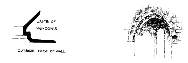
Fig. 687.—Cowie Church. Fig. 688.—Cowie Church. Inside of East Windows.
The three lancet windows in the east end (Fig. 686) are the only features with noticeable details. They are of different heights, and are arranged in good proportion. The external jambs and arches have an outer splay (see section, Fig. 687), inside of which they are checked for shutters, the windows having never been glazed. The arched heads have pointed and splayed rear arches and wide ingoings (Fig. 688).
THE ABBEY OF DEER, Aberdeenshire.
This monastery was situated in a beautiful valley on the banks of the river Ugie, one mile and a quarter south-west of Mintlaw Railway Station. It was founded in the year 1218 by William, the first Earl of Buchan, who, by his marriage in 1210 to Marjory, the only child of the last Mormaer of Buchan, became the founder in the north of the powerful family of the Cumyns. He died in the year 1233, and was buried in the abbey. In consequence of the accession of the Earl of Carrick to the Scottish throne, the Cumyn family, who had opposed the Bruce, were so completely overthrown that, says Fordun, “of a name which numbered at one time three earls and more than thirty belted knights, there remained no memorial in the land, save the orisons of the Monks of Deir.” Now not one stone of the abbey church is left standing, and only a few fragments of the conventual buildings remain. This is much to be regretted, especially as it is known that considerable remains of the church existed down till 1854.
About the year 580 a church was founded in Deer by St. Columba and his nephew Drostan, on ground supplied by the Mormaer of the district as a return for the prayers of the saint in favour of his sick child. This Columban establishment survived till the time of David I., and was superseded by the monastery founded, as above stated, by the Earl of Buchan for a colony of monks of the Cistercian order from Kinloss. The site of the church (Fig. 689) is marked on the ground by an excavation over its whole area. The structure consisted of a nave about 98 feet long by 40 feet wide, including a north aisle, an aisleless choir or presbytery about 25 feet long and 24 feet wide, and north and south transepts. The total length of the church over all was 157 feet. The nave had a north aisle, and was divided into five bays. The bases of the pillars remained in position till 1854. The south transept was 39 feet wide, or about 6 feet 2 inches wider than the northern one, and it had probably a narrow eastern aisle.
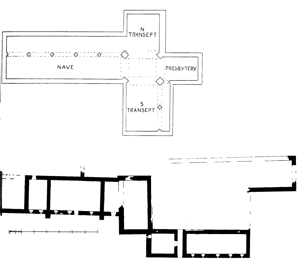
Fig. 689.—The Abbey of Deer. Plan.
The conventual buildings lay on the south side of the church, and are built on ground sloping southwards towards the Ugie, so that a basement story was required. The interior of the whole range of buildings is so overgrown with vegetation and filled with debris that it is with the utmost difficulty one can make his way through the ruins, and thus an accurate examination of the place is hardly possible.
The cloister was about 70 feet from north to south by about 90 feet from east to west. On the south side there is a range of buildings about 125 feet long by 31 feet wide, divided into four apartments, forming the basement story, over which the refectory was probably built. To the east of this, lying north and south, is the fratry, measuring 35 feet in length by about 19 feet in width inside. Projecting southwards beyond the fratry by its full width a long range of buildings extends 80 feet eastwards, and measures about 21 feet in width over the walls. At the west end of this range there is an apartment about 20 feet from east to west by about 16 feet wide, which may probably have been the kitchen. In the north wall of this apartment there is a flue about 10 inches square. The room enters from a passage adjoining on the east side. There appears to have been a stair in this passage leading down to the lower buildings, and probably up to the dormitory, but the block of ruins at this part is so great as to render further observation impossible. Of the buildings which occupied the east side of the cloister all traces have now disappeared.
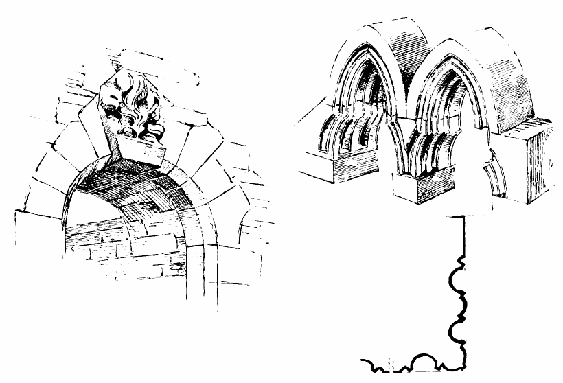
Fig. 690.—The Abbey of Deer. Doorway in Passage. Fig. 691.—The Abbey of Deer. Arches in the Ruins.
It is highly probable that the church was completed before the monks erected any permanent dwelling for themselves, and this may partly account for the resignation of the tenth abbot, Dene Adam of Smalham, a monk of Melrose, who demitted office in 1267, “choosing rather to live in the sweet converse of his brethren of Melrose, than to Govern an unworthy flock, under the lowly roofs of Deir.”[105]
All the conventual buildings now existing are of a date subsequent to the founding of the abbey, but under the circumstances already narrated, and from the absence of mouldings, it is somewhat difficult to fix their period. The openings are all round arched and simply splayed. The doorway into the passage adjoining the kitchen has a carved keystone (Fig. 690), a rather unusual feature in Gothic work. The carving, which is cut in granite, is decidedly Gothic in feeling, although in all probability late. There exists a view of the abbey as it existed in 1770.[106] The view appears to have been taken from the south, although it is rather difficult to fix the point of view; but, assuming that it is from the south, it shows the north wall of the building just described as in a much better state of preservation than it is now, and the south wall as rather more ruinous. We understand that the north wall was repaired sometime in this century. Judging from the view and from the remains, the south elevation seems to have been finished with a series of gables, having round-arched and splayed windows. Only a few fragments of the church remain, and there can be no doubt as to their period. They are genuine relics of the original church founded in the thirteenth century. The principal fragment consists of two cusped arches (Fig. 691), probably forming the top of a sedilia. They measure in width 1 foot 10½ inches each by 2 feet 3½ inches high inside, and are recessed about 12 inches.
Three or four corbels of the characteristic first pointed kind are preserved; one of these is shown in Fig. 692.
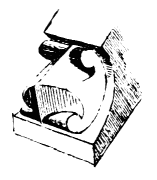
Fig. 692. The Abbey of Deer. Corbel.
The only other wrought stone belonging to the church is a very peculiar one. It lies loose, and appears to have contained a double piscina—one having its basin supported by a projecting corbel in the ordinary manner, and the other with its basin and corbel turned upside down. Its construction will be understood from the sketch (Fig. 693). In the one basin, which may be called the upper, the aperture proceeds from a sprout at the back, and emerges in the centre of the lower basin. The upper basin is 7 inches deep and the lower 3½ inches. The other dimensions will be seen on the drawings, with sections of the respective corbels.
Adjoining the ruins is the Abbey Bridge, spanning the Ugie. It is a quaint structure, and may be partly as old as the remains of the conventual buildings; but it appears to have been repaired or partly rebuilt, as it contains the arms of James Keith of Bruxie, with the date 1718.
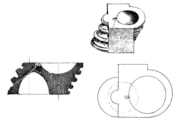
Fig. 693.—The Abbey of Deer. Piscina.
DEER CHURCH, Aberdeenshire.
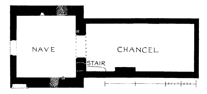
Fig. 694.—Deer Church. Plan.
This church is situated in a beautiful bend of the river Ugie, in the churchyard of the village of Deer, and is rather more than a mile distant from the abbey. It is roofless, but the walls stand at about their original height, and consist of a nave and chancel (Fig. 694). The nave is of an unusual form, being wider than it is long; but it is probable that it was originally longer than it now is. The exterior width is 26 feet 10 inches, and the length 24 feet 3 inches. The chancel is 37 feet 7 inches long by 16 feet 9 inches wide externally. It is separated from the nave by a wall containing a round splayed arch, 7 feet 6 inches wide, and (owing to the present level of the ground) only 6 feet 6 inches high in the centre. The level of the floor was, doubtless, originally a foot or two lower. The present entrance doorway to the nave is modern, and is in the centre of the west end. There are the marks of an old doorway in the north wall, which show a plain arched construction inside, and in this a window has been inserted at a late period. Another square-headed window in the south wall completes the lighting of the nave. There has also been a square-headed doorway in the south wall. There are two piscinas in the nave—one adjoining the chancel arch on the north, and having its basin in the depth of the recess; the other (Fig. 695), in the south wall, had a projecting basin, which is now sliced off. The most interesting and perfect feature of the church is the locker or ambry in the north wall of the nave (Fig. 696). The top is of a drop-arched form. The arch and the jambs and sill are checked for a door in the usual manner. Above the door, and visible whether the door was shut or open, is a pointed arch with a kind of rude tracery enclosing a cross pattee cut out of grey granite. The locker is 13 inches wide.
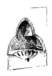
Fig. 695. Deer Church. Piscina in South Wall.
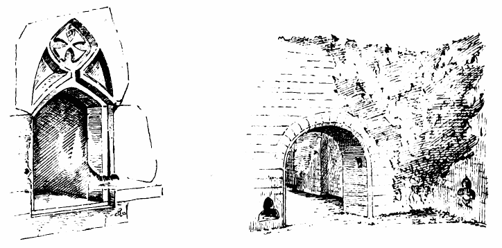
Fig. 696.—Deer Church. Ambry in Nave. Fig. 697.—Deer Church. Chancel Arch.
Sockets in the wall at the springing of the chancel arch (see Fig. 697) indicate the former existence of a rood screen. In the south side of the chancel there remain the indications of a stair which led up to a narrow door, now built up, the sill of which is at about the level of the springing of the chancel arch (Fig. 698). Unless this led to some kind of pulpit from which an audience in the nave could be addressed, it is difficult to determine its use. The wall here on the nave side is so completely covered with ivy that this point could not be made out.
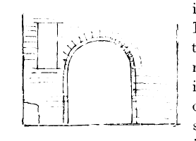
Fig. 698.—Deer Church. Chancel Arch and High Door.
The walls appear to have been in part rebuilt, especially the south wall of the chancel near the east end, where there are visible, both outside and inside, stones having fifteenth or sixteenth century rosettes carved on them. In the east wall there is a finely carved heraldic stone (Fig. 699) with the arms effaced.
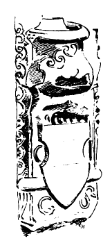
Fig. 699. Deer Church. Heraldic Stone.
There is an arched recess for a monument (Fig. 700) on the exterior of the south side of the nave at the west end, which can hardly be seen for the dense growth of ivy. The sculptured stones and coat of arms are evidently insertions.
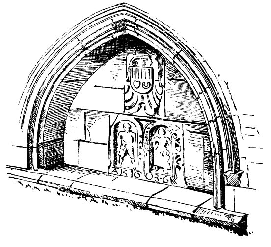
Fig. 700.—Deer Church. Recess of Monument.
Deer is the site of a very early monastery, founded by St. Columba, of which the venerable Book of Deer is the only remaining memorial. It was written in the ninth century, and contains the Gospel of St. John, with portions of the other gospels, and notes on the margins relating to the monastery written in Gaelic at a later period. The existing church has no connection with this ancient monastery further than that it probably occupies the same position. It was, doubtless, erected about the fifteenth century.
AUCHINDOIR CHURCH, Aberdeenshire.
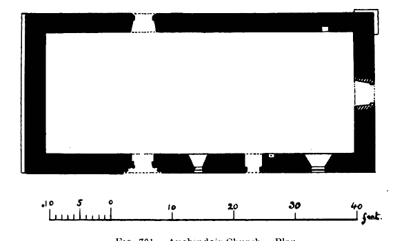
Fig. 701.—Auchindoir Church. Plan.
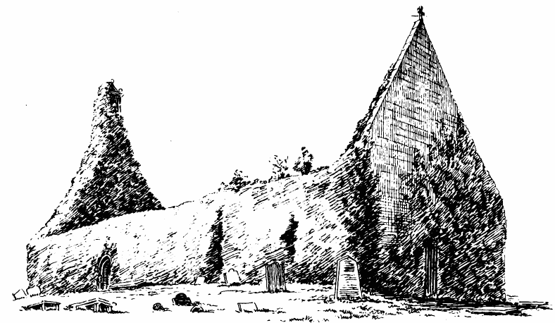
Fig. 702.—Auchindoir Church. View from South-East.
The ruined church of Auchindoir is situated in a remote part of Upper Aberdeenshire, about six miles south-west from Kennethmont Station, between Insch and Huntly. It stands on a slight elevation near the mouth of the Craig Burn, which joins the river Bogie a short
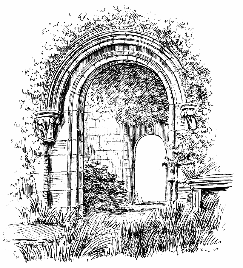
Fig. 703.—Auchindoir Church. South Doorway.
distance below. It has been pointed out by Mr. Jervise[107] that the orientation of the church is peculiar, as it stands more north and south than east and west; but in the following description the usual orientation is assumed. The church is a simple oblong (Fig. 701), measuring 50 feet in length by 19 feet 6 inches in width internally. Mr. Jervise thinks it has been added to at the west end, and it has at least been altered at that point, and a belfry added on the top of the gable (Fig. 702). The rest of the building has also been considerably altered, and a doorway inserted in the east end and square windows introduced to make it suitable for Presbyterian worship.
Towards the west end there are two doorways, opposite one another, in the north and south walls. That in the south wall (Fig. 703) is a fine specimen of early first pointed work. The round arch is retained (as is common in Scotland), but the details are all of first pointed design. The section of the jamb and arch mouldings (Fig. 704) and the dog-tooth enrichment of the label are clear indications of that style. Mr. Jervise doubts whether these features are genuine, and suspects that they are late imitations of the first pointed style; but Mr. Muir has no doubt about the doorway being of “late transition work, belonging, apparently, to that precise period in the progress of the art when the already softened features of the Normans were beginning to merge altogether into the still more flexible and varied forms of the first pointed style.” This opinion is confirmed by all the features of the doorway. The bold foliaged caps on each side (of which the detached shafts are gone) are undoubted proofs of the genuine nature of the work. This doorway could never have been produced in later times.
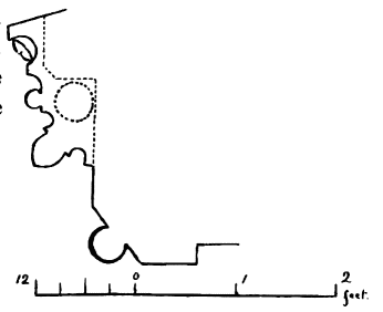
Fig. 704.—Auchindoir Church. South Doorway: Jamb and Arch Moulding.
The north doorway is simple, having a plain round arch with a splay on edge, and a recess for a bolt in the ingoing.
The church contains a simple piscina in the south wall, and a very elaborate ambry, or sacrament house (Fig. 705), in the north wall near the east end. The decorated adjuncts of this ambry are about 6 feet in height. The opening is moulded, and has a quasi buttress on each side, crowned with a crocketed pinnacle in a late style of art. A pointed roof, or flat canopy, rises over the ambry, having on the top a representation of the crucifixion, with a skull carved at the base; over the cross is a scroll bearing the letters I N R I. There are two scrolls on the roof, carved with the inscription, HIC·Ē CORP DUĒ C V M, and on the sill of the ambry, M·A·S·, which inscription Mr. Jervise renders thus: “Here is the body of our Lord, with Mary, the Apostles, and Saints.” The ambry has an inner recess on the left side.
This work is evidently very late in style, but it can scarcely be so late as Mr. Jervise supposes. He says:—“I am inclined to ascribe the erection of the Sacrament House, if not the Kirk, of Auchindoir to the laird and lady whose arms and initials are upon shields within it. One of these shields, dated 1557, bears the Gordon arms and motto, HOIP IN
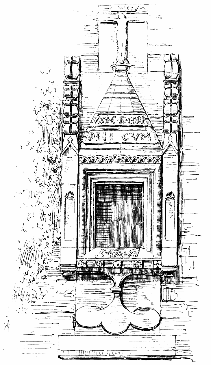
Fig. 705.—Auchindoir Church. Sacrament House.
GOD; the second, initialed V·G:C·C·, presents the arms of Gordon and Cheyne, impaled with the motto, GRACE ME GYID.”
There can be no doubt that Mr. Jervise is in error as to the church being erected in 1557; but it was probably altered at that date, as the eastern or priests’ doorway in the south wall (which is now square headed, and has a transome and upper light over it) bears the date 1557. That was probably the time when the church was altered for Presbyterian worship. The sculptured ambry was probably executed in the early part of the sixteenth century, before the Reformation.
In 1513-14 the Church of Auchindoir was erected into a prebend of King’s College Chapel, Aberdeen. That would be a likely time for the introduction of the sacrament house. The building continued to be employed for divine service till 1810, when a new church was erected in the neighbourhood. The old churchyard which surrounds the old church is still used for interment.
When this church ceased to be used for service, the roof and woodwork were sold, and some of the panelling, including the back of the pulpit, which is carved with shields, is preserved in a farmhouse in the vicinity.
ST. CUTHBERT’S, Monkton; AND ST. NICHOLAS’, Prestwick, Ayrshire.
These two ruined churches are situated within a mile of one another on the level ground near the sea, which forms the basin of the river Ayr, near its mouth.
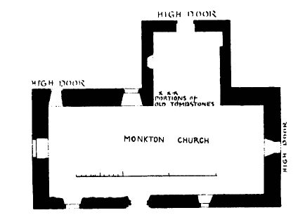
Fig. 706.—St. Cuthbert’s Church. Plan.
Prestwick is an ancient town, which had a parish church; while Monkton derived its name from the residence of a body of monks from Paisley. Both St. Nicholas’ and St. Cuthbert’s were originally churches of Prestwick, and were distinguished as Prestwick de Burgo and Prestwick Monachorum. Both these churches were bestowed on Paisley Abbey, in 1163, by Walter, son of the Great Steward of Scotland, and endowed with valuable lands.
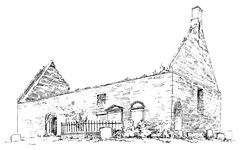
Fig. 707.—St. Cuthbert’s Church. View from South-East.
Prestwick Church is mentioned in the Paisley Chartulary, in 1212, as a chapel; Monkton continued as a rectory till the Reformation, and the two parishes were united in the beginning of the seventeenth century. Till 1837 both churches were used for public worship.[108]
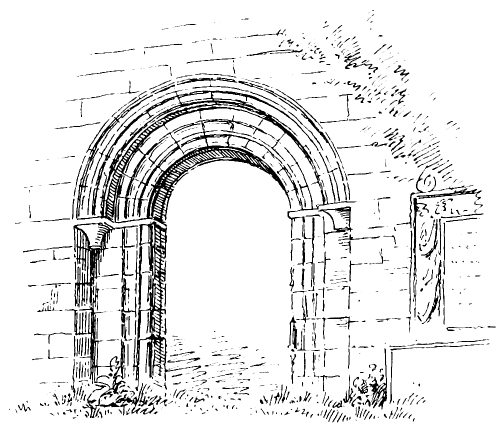
Fig. 708.—St. Cuthbert’s Church. South Doorway.
The Church of St. Cuthbert (Fig. 706), at Monkton, has originally been a simple oblong chamber, 46 feet in length by about 20 feet in width internally. The walls of this part of the structure are undoubtedly ancient, but they have been considerably altered, and a north wing has been added after the Reformation. The belfry (Fig. 707) erected at that period still exists on the east gable.
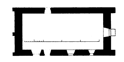
Fig. 709.—St. Nicholas’ Church. Plan.
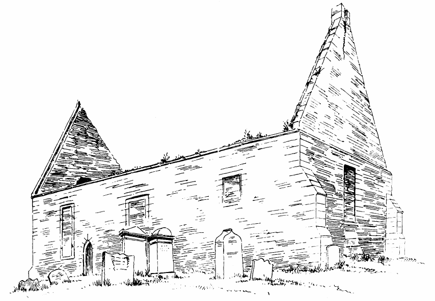
Fig. 710.—St. Nicholas’ Church. View from South-East.
The only portion of the building which proves its antiquity is the doorway in the south wall (Fig. 708). It has a round arch, but the mouldings are of thirteenth century forms. There has been a nook shaft on each side with bell-shaped caps, and an inner order with a large roll. This fragment is precious as one of the few ancient features which have escaped obliteration in this part of the country.
St. Nicholas’ stands on a mound close to Prestwick Railway Station, and is surrounded by an ancient burying-ground. The church (Fig. 709) is a simple oblong, 44 feet long by 20 feet wide within the walls. It is a very plain structure, and has evidently been altered, having square-headed windows (Fig. 710) inserted so as to render it suitable for Presbyterian service. The only noticeable features are the buttresses at the east end. There are two of these, one at each side and a small one in the centre, which are massive and present the appearance of early work. Doubtless they and the walls are old, but have been altered. There has been a plain belfry on the east gable, now reduced to a portion of the base. There are three small buttresses at the west end, but they are of a slighter character than those at the east end.
LUFFNESS MONASTERY, Haddingtonshire.
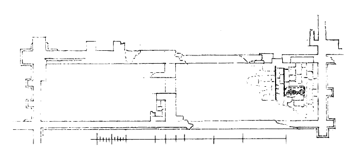
Fig. 711.—Luffness Monastery. Plan.
The monastery of the Redfriars at Luffness is believed to have been founded by Patrick, Earl of Dunbar, in 1286. The remains of the church, which consist for the most part of foundations, are situated in the private grounds of Luffness House, not far from the junction of the Peffer Burn with Aberlady Bay, and about half a mile from the village of Aberlady. The church (Fig. 711) has consisted of nave and choir, without aisles, the choir being internally 49 feet and the nave 42 feet in length, and both about 19 feet 6 inches wide. Both show the bases of buttresses at the east and west ends, and there seems to have been a wall between the nave and choir, which possibly sustained the rood loft. In the north wall of the choir and near the east end (Fig. 712) are the remains of an arched recess, which contains a much worn effigy, supposed to be that of the founder.
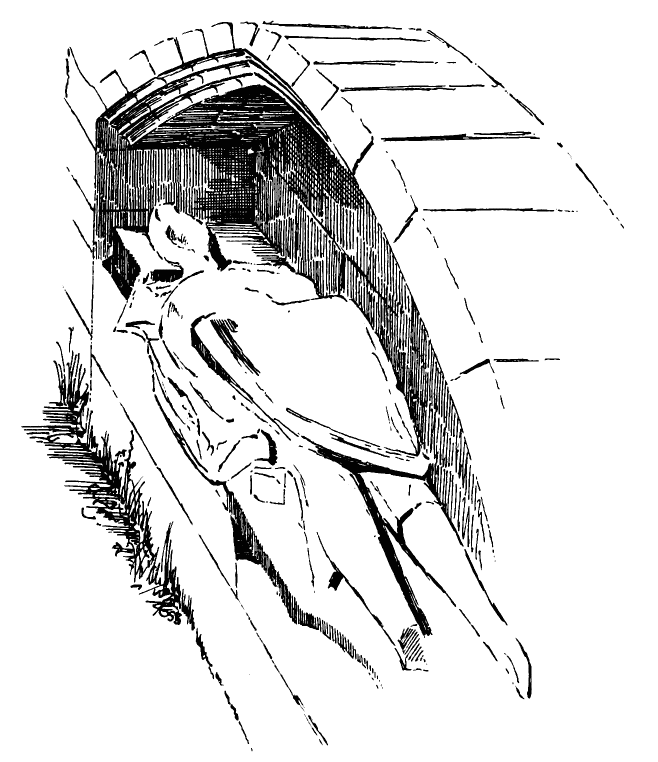
Fig. 712.—Luffness Monastery. Monument in Choir.
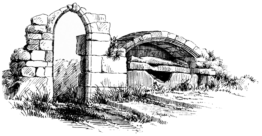
Fig. 713.—Luffness Monastery. Choir.
A pointed doorway leading to the choir adjoins the monument (Fig. 713), and the altar steps are seen rising beyond it. Part of the pavement still remains at the east end, and in the centre is a flat monumental slab (Fig. 714), much decayed, but on which can still be made out the following inscription:—“(Hic jacet) honorabilis vir Kentigernus Hepburn (dominus?) de Wauchtoun;” and the sacred monogram “I.N.R.I.” on the upper part of the cross. Kentigern Hepburn was son and heir apparent of David Hepburn of Wauchton. He received, on 5th September 1498, a charter from his father of certain lands—viz., the lands of Quhiltinfuld in Edinburgh, half a plougate in Cockburnspath and lands of Elstanefurd, with superiority of lands of Towly in Fife and Elstanefurd. He also held, from his father, a charter of the lands and barony of Luffness. He married Margaret Lauder (see Great Seal, 1424-1513). The arms on the shield in the centre of the cross are those of the Hepburns. The style of the slab would indicate that of the fifteenth century.
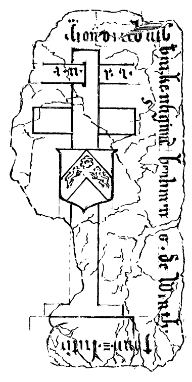
Fig. 714.—Luffness Monastery. Monument in Choir.
ALTYRE CHURCH, Morayshire.
About four miles south of Forres, and in the middle of an extensive forest, not far from Altyre House, stand the ruins of an ancient first pointed church. The parish of Altyre belonged formerly to the parsonage of Dallas, but in 1659 it was disjoined from Dallas and added to the parish of Rufford. The ruins of the church, which stand in a dense thicket of bushes, are in fair preservation. The building is very plain, consisting of a simple oblong chamber (Fig. 715) about 50 feet in length by 15 feet in width internally. There appear to have been no buttresses originally, but one has been added at the north-east angle (Fig. 716), and
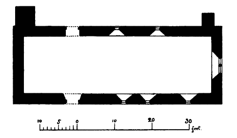
Fig. 715.—Altyre Church. Plan.
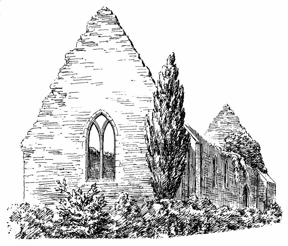
Fig. 716.—Altyre Church. View from North-East.
a very massive prop has been built at the north-west angle, the ground on the north being a bank sloping downwards from the church. There are two doorways opposite one another near the west end, one in the north wall and one in the south wall. In the east wall there is a two-light window with simple branched mullion. The side windows are plain lancets, there being two in the north wall and three in the south wall. The west wall is blank. The walls and gables are still standing. Although the church may be classed as first pointed, it is evidently of the latest period of that style.
ST. MARY’S CHAPEL, Rattray, Aberdeenshire.
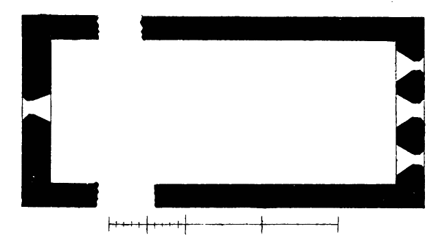
Fig. 717.—St. Mary’s Chapel. Plan.
This chapel, standing in the centre of its churchyard, is situated at the east end of the lonely loch of Strathbeg, not far from Rattray Head, a place well known and feared by sailors. It measures internally 45 feet from east to west by 18 feet 9 inches from north to south (Fig. 717). The gables are nearly entire, with considerable portions of the side walls. Almost all the stone dressings within reach have, as usual, been torn out for common purposes, so that the building is in a tottering condition, and is greatly robbed of its interest; but enough remains to show that it is a genuine church of the thirteenth century. It is built of rough angular stones, with red freestone dressings. In the east wall (Fig. 718) there are three round-arched and widely splayed windows, the centre one being the highest and widest, viz., 2 feet wide and, according to the new statistical account (which appears to be reliable), 11 feet high, and the other two are each 7 feet high. The gable itself is said to be 32 feet high in its present condition. There appear to have been north and south doors near the west end, and no other openings in the side walls. In the west gable there is a window 8 or 10 feet above the ground, and from 3 to 4 feet wide. The church has thus been entirely lighted from the east and west ends. It is needless to say that there are no remains of any of the usual internal features, the polished stones of such having been carried off, forming too strong a temptation to be resisted.
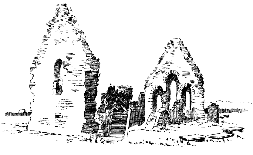
Fig. 718.—St. Mary’s Chapel. View from South-West.
The earliest notice of this chapel is between the years 1214 and 1233, when William Cumyn, Earl of Buchan, gives certain lands for the yearly payment of two stones of wax, afterwards given by the Earl “in free alms for ever to the Chapel of the Blessed Virgin Mary in the town of Rettre in Buchan.”[109] Again, in 1451, the chamberlain of the crown lands in Buchan makes a deduction of six shillings, “paid to the Chaplin of Rattre.” And in 1460 King James III. confirms a charter for a yearly payment of five pounds and the third part of a stone of wax to the chapel of the “Beate Marie Virginis de Ratreff.”[110]
ST. MAGRIDIN’S CHURCH, Abdie, Fifeshire.
The parish of Abdie is situated in the north of Fife, about two miles south from Newburgh. It was originally called the parish of Lindores, but that name was appropriated by the abbey, which was also founded in the same parish. The loch of Lindores, on the south bank of which the ruins of the church of Abdie stand, still retains the ancient name. The church was of much earlier date than the abbey, and Mr. Laing[111] states that there can be little doubt that the church of Lindores (now Abdie) was of Culdee origin, and was one of the earliest religious settlements in the country. The name Lindores signifies the “church by the water,” a peculiarly appropriate designation in this instance. “In a writing of the thirteenth century on a fly-leaf of a volume preserved in the Imperial Library, Paris, it is recorded that the consecration of ‘Ebedyn’ church by David de Bernhame, Bishop of St. Andrews, took place on the 5th day of September A.D. 1242, a date which corresponds with the style of its architecture.”[112]
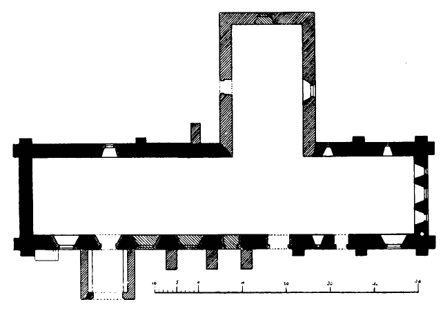
Fig 719.—St. Magridin’s Church. Plan.
From the foundation charter of the abbey of Lindores we find that the first bequest it received was the church of Lindores, and the lands belonging to it.
The existing structure consists (Fig. 719) of a plain oblong chamber, which has been greatly rebuilt, but part of the walls of which may be of the thirteenth century. The building measures internally 88 feet in length by 17 feet 6 inches in width. The east end or chancel is the most ancient part. It is about 30 feet in length, and has first pointed buttresses and small lancet windows in the side walls. One of the lancets remains in the south wall (Fig. 720), and two in the north wall (Fig. 721). There is also a pointed priests’ doorway in the south side wall. The three pointed windows in the east end seem to have been altered. The broad
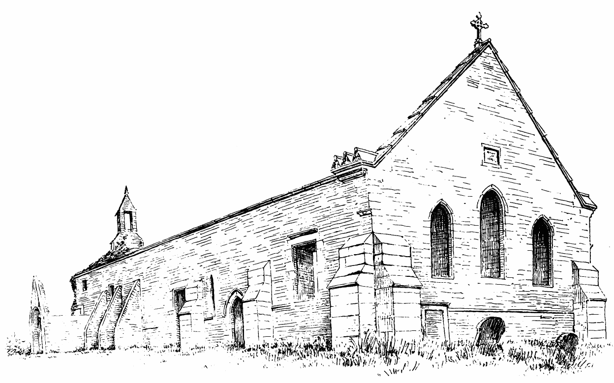
Fig. 720.—St. Magridin’s Church. View from South-East.
skew, with cross on the gable, and its remarkable footstone are restorations. The nave or western portion of the church, which is of the same width as the chancel, has been rebuilt at different times, and much of it shows in its windows, buttresses, &c., work of a very late period, probably the sixteenth century. There is a south porch near the west end, with a stone bench on each side. The entrance is by an elliptic arch, with plain splay on edge. The belfry is plain, but picturesque. A wing or north aisle has been added at a late date. It is called the Denmiln aisle, and was erected by Sir Robert Balfour in 1661, and bears his arms and the date over the doorway. In the choir there is a slab with a fine cross carved on it, and also a recumbent effigy (see Fig. 721), considerably worn away by the weather.
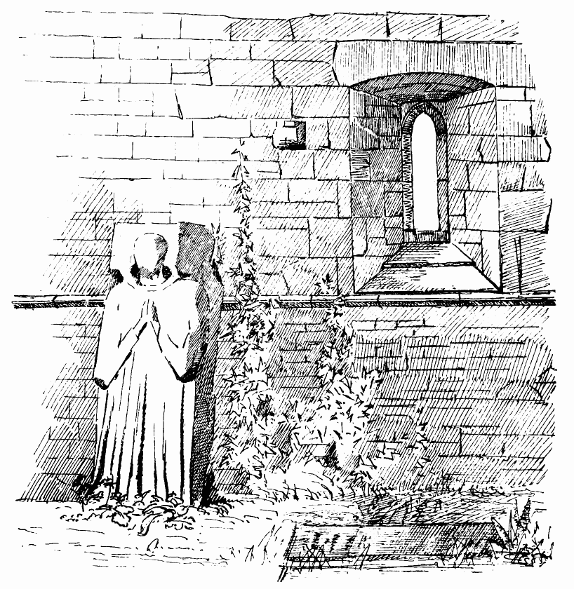
Fig. 721.—St. Magridin’s Church. Effigy in Choir.
CHAPEL ON “THE ISLE,”[113] Wigtonshire.
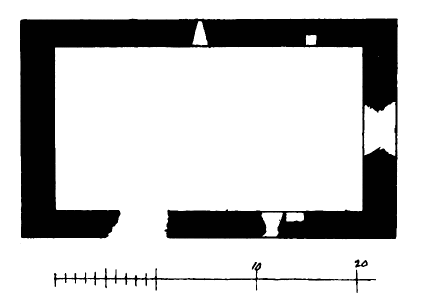
Fig. 722.—Chapel on “The Isle.” Plan.
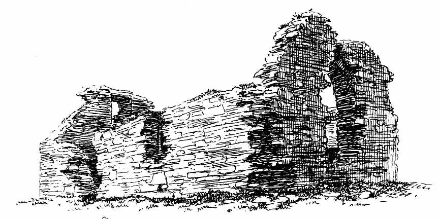
Fig. 723.—Chapel on “The Isle.” View from South-East.
“The Isle” is a rocky promontory, formerly an island, but now connected with the mainland at low tide. It stands near the south end of the main part of Wigtonshire, about two miles north from Burrow Head and three miles south-east of Whithorn. On this isle stand the ruins of an ancient chapel. It is roughly built, with walls 2 feet 8 inches in thickness, and, from its pointed arches, appears to be of first or second pointed date. The structure (Fig. 722) measures 37 feet 6 inches in length by 22
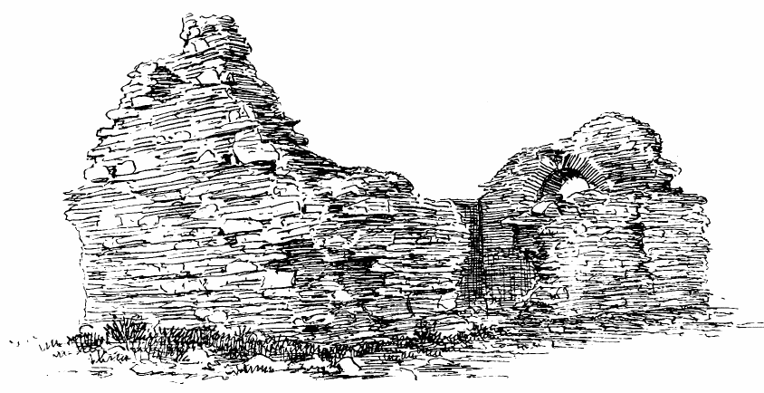
Fig. 724.—Chapel on “The Isle.” View from South-West.
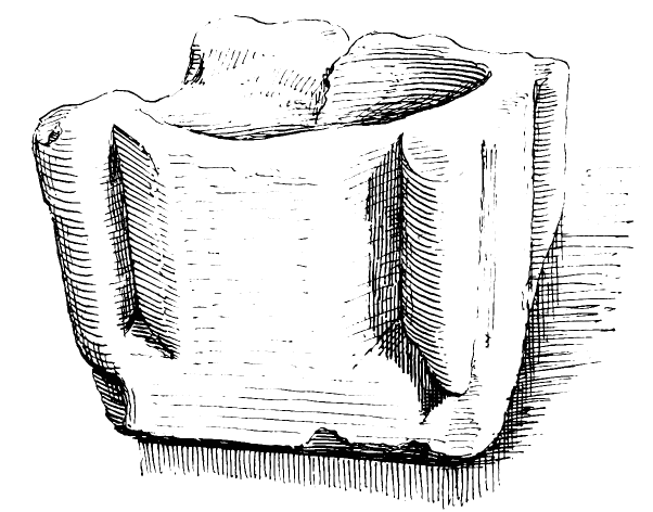
Fig. 725.—Chapel on “The Isle.” Font.
feet in width externally, and has originally been very exactly measured off. The doorway has been in the south wall, but it is now broken down and the freestone dressings removed. There has been a tall pointed window in each of the north and south walls, and a similar window, though apparently wider, in the east end wall. The dressings have been torn out, but the pointed sconsion arches still remain (Figs 723 and 724). There is a small square ambry in the north wall, and a similar, but larger, one in the south wall. The exterior is quite plain, and without buttresses or break of any kind.
The simple bowl of the font has been recovered, after having served for generations as a trough to bruise whins in for food for horses (Fig. 725). It is now preserved at Whithorn.
Much discussion has taken place regarding this chapel, some supposing it to be the original Candida Casa of St. Ninian. The style of the structure puts that view out of the question; but it is still thought by some—amongst others by Mr. T. S. Muir[114]—that the isle was a much more likely place for St. Ninian to fix his first settlement on than at Whithorn, where he would be in the midst of a probably not very friendly people. In that case the Chapel on “The Isle” would be the successor of the original Candida Casa. But there is nothing at either place to determine with any degree of certitude the site of the first Christian edifice in Scotland.
CHAPEL, DUNSTAFFNAGE CASTLE, Argyleshire.
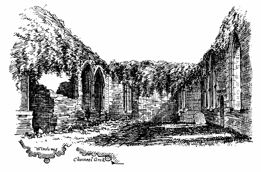
Fig. 726.—Chapel, Dunstaffnage Castle. Interior.
A plan and detailed drawings of this first pointed chapel are given in connection with the description of the castle,[115] but the general view of the interior (Fig. 726) is now illustrated, in order more fully to explain the description above referred to. The ruin is densely covered with ivy, but the jambs of the chancel arch, enriched with rows of dog-tooth ornament, are distinctly visible (see Section). The arch is now built up, and the chancel is converted into a tomb-house. A section of the window jambs and shaft between is also shown in Fig. 726. This edifice is one of the few examples of enriched first pointed work to be found in the Western Highlands and Islands.
Another very interesting specimen of a first pointed church exists at Skipness, Kintyre, which is also described and illustrated in The Castellated and Domestic Architecture of Scotland.[116]
BUITTLE CHURCH, Kirkcudbrightshire.
A ruin, situated about three to four miles west from Dalbeattie. The original name was Kil-Ennan, that of Buittle being comparatively modern. A notice of the church occurs as early as 1275, when it was granted by Devorgilla to the monks of Sweetheart; and on the 16th July 1381, Pope Benedict XIII. confirms a charter by Thomas, Bishop of Galloway, granting the Church of St. Colmanel of Butyll to the Abbey of Sweetheart. We are informed that a new church was erected before the Reformation. This was, doubtless, part of the present ivy-clad ruin. The church and lands were annexed to the Crown in 1587.[117]
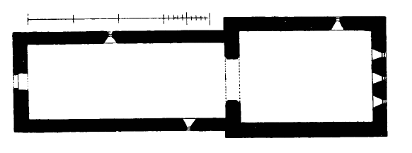
Fig. 727.—Buittle Church. Plan.
The building is peculiar in form (Fig. 727), the choir being wider than the nave—the former measuring 26 feet 6 inches, and the latter 22 feet in width over the walls. The choir is about 30 feet and the nave 44 feet in length internally. The walls and gables are well preserved (Fig. 728), but the whole building is so completely covered with ivy that any architectural features which may exist are concealed. There is a pointed chancel arch between the nave and choir, and the latter part of the church is lighted with three lancet windows in the east gable.
To judge from the appearance of the building the nave and its belfry were, doubtless, the parts erected shortly before the Reformation, and the choir is the more ancient portion. It is probably of first pointed date.
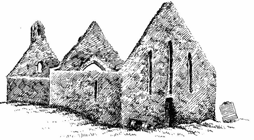
Fig. 728.—Buittle Church. View from South-East.
The straight lintelled doorway in the east end, under the three pointed windows, is part of the work done in Presbyterian times.
TUNGLAND ABBEY, Kirkcudbrightshire.
Of this ancient and important abbey there now remains only one doorway (Fig. 729). The abbey stood on a level piece of ground at some height above the rocky bed of the River Dee, about two miles from Kirkcudbright. The situation is a fine one, and the modern manse is yet surrounded with splendid old trees. The abbey was founded by Fergus, first Lord of Galloway, in the twelfth century, and occupied by Premonstratensian Monks from Cokersand Abbey, in Lancashire. The abbot sat in the Parliament summoned at Brigham, in 1290, to settle the succession to the Crown of Scotland. Robert I. and David II. both enriched it with endowments.
In 1503 James IV. appointed Damiane, an Italian, to be abbot. He was an alchemist, and professed to be able to fly; but in endeavouring to carry out his scheme from the walls of Stirling Castle, his wings gave way, and he fell and broke his leg.[118]
The abbey was annexed to the Crown in 1587. Symson mentions that in 1684 the steeple and part of the walls were standing. It is said that the present church which adjoins is erected on part of the walls of the old abbey.
The part of the abbey which contains the ancient door has evidently been refitted as a church in post-Reformation times, and has a gable with a plain belfry.
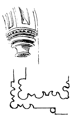
Fig. 729.—Tungland Abbey. Doorway.
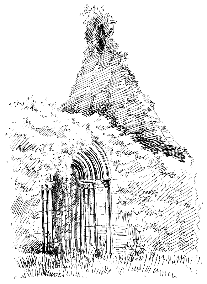
Fig. 730.—Tungland Abbey. Details of Doorway.
The old doorway has some features (Fig. 730) which make it doubtful whether it belongs to the first pointed style, or is only one of the reproductions in imitation of that style which were common in the time of James VI.
COCKPEN CHURCH, Mid-Lothian.
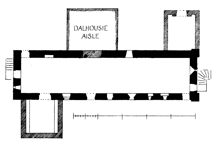
Fig. 731.—Cockpen Church. Plan.
The ruins of the ancient parish church of Cockpen stand in a burial ground about one mile south from the modern parish church, which is situated about a mile from Dalhousie Railway Station. The walls of the old church are in tolerable preservation, but they have been so much altered, probably soon after the Reformation, so as to render them suitable for Presbyterian worship, that the original features are almost obliterated. The structure (Fig. 731) is a simple oblong, 65 feet 6 inches in length by 15 feet 2 inches in width. There are some remains of narrow lancet windows at the east end, but they have been much altered, one of them being widened to form an outside doorway to a gallery. The side windows have been similarly altered and new square-headed windows inserted, so that almost all trace of the original features is lost. The ruins are also so completely covered with a dense growth of ivy that the details of the architecture cannot be properly investigated. Some burial vaults have been thrown out from the side walls, probably in the sixteenth century. From the scanty materials available it may be inferred that the original church was a structure of the thirteenth century.
PENCAITLAND CHURCH, Haddingtonshire.
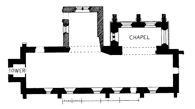
Fig. 732.—Pencaitland Church. Plan.
This structure, which is still in use as the parish church, lies in the valley of the Tyne, about four miles south from Tranent. It consists (Fig. 732) of a long narrow building measuring about 83 feet in length by about 23 feet in width over the walls, with a western tower, not quite square in plan. On the north side of the chancel there is a chapel of first pointed work, and adjoining it on the west a seventeenth century aisle. Taking the chapel on the north side first as being architecturally the most important, it measures in the inside about 22 feet 8 inches long by about 10 feet wide. On the north side (Fig. 733) it is divided into two bays, and had originally shallow buttresses of 18 inch projection, terminating with a gabled top. The buttresses have been enlarged at a later date. Between the buttresses there were large pointed windows, probably once filled with tracery, but which is now destroyed. There is another wide window in the east end, which has met with the same treatment. In the west end there is a high window of two lights, with a pierced opening in the apex under the arch. The mouldings round the windows consist of thin reed-like beads, separated by deep narrow hollows. The labels round the outside terminate as shown in Fig. 734. Over the buttresses there is a set-off on the wall (see Fig. 733), and above this one deep course of masonry, carrying a corbel course of small size, decorated with human and animals’ heads. The top course and set-off are closed in at each end with a large skew stone, on which there is wrought the original start of the sloping gable at a slightly lower level
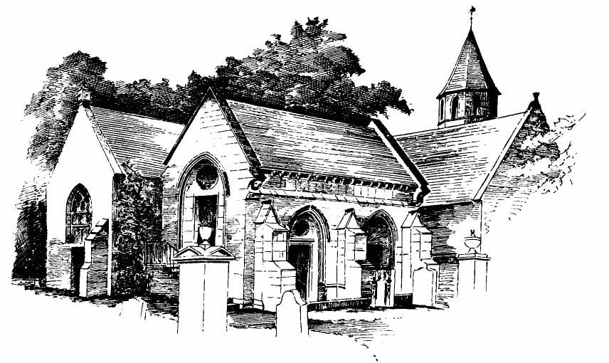
Fig. 733.—Pencaitland Church. View from North-East.
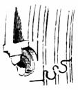
Fig. 734. Pencaitland Church. Moulding of Windows.
than the existing gable (Fig. 735), showing that there has been some change made here, the existing skew puts of gables not being original. The north wall is bent outwards considerably. It is not unlikely that the chapel was originally vaulted in stone, and, with the view of strengthening it, the shallow buttresses have been enlarged as indicated. The wide opening into the church shown on the Plan was afterwards made, and the vault, thus losing its support on that side, would be taken down. As a confirmation of the opinion that this chapel was vaulted we find[119] that the roof was at one time covered with flagstones. These, owing to their weight, are generally found only on vaulted buildings, as at Borthwick and numerous other churches. From the appearance of the flat arch of this opening it seems to be of later work than the chapel, and on the east side of the ingoing there are the remains of what appear to have been the jambs of a doorway. The chapel would thus originally be separated from the church by a solid wall with a door of communication, and what we have called a chapel may have been the sacristy. This separating wall, it will be observed from the Plan, is much thicker than the buttressed north wall, and, doubtless, was so made for the purpose of resisting the thrust of the vault.
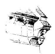
Fig. 735. Pencaitland Church. Skew Stone.
Although the church adjoining appears to be mainly a building of the sixteenth and seventeenth centuries, it undoubtedly occupies the site of an earlier church, known to have existed at Pencaitland in the twelfth century. Possibly portions of this earlier church are incorporated in the existing walls, and it is not unlikely from the narrowing of the east end on the north side (see Plan) that a chancel arch may have existed. Over the tower doorway there is the date 1631, with the initials of the incumbent, John Oswald, who probably built the tower. About the same time the north-west aisle was built. It contains some details resembling those to be seen at Wyntoun House, in the immediate neighbourhood. In the Caledonia, Vol. II. p. 527, Chalmers mentions that Pencaitland was possessed by Everard de Pencaithlan, and that he probably obtained the lands from William the Lion (1165-1214), as he granted the church of his manor of Pencaithlan to Kelso, with its tithes and other rights, in pure alms for the salvation of his lord, King William. After 1309 it is not mentioned among the churches belonging to Kelso. The manor was forfeited during the War of Succession, and was granted by King Robert the Bruce to Robert de Lawder; but soon after it appears in the hands of Sir John Maxwell, younger brother of Sir Eustace Maxwell of Caerlaverock, who granted to Dryburgh the advowson of the church with an annuity from his lands of Pencaitland. This was confirmed by William (Landal), the Bishop of St. Andrews, in 1343, and by David II. two years later. A view of the tower and west end of the church, with some details, will be found in The Castellated and Domestic Architecture of Scotland.[120]
GOGAR CHURCH FONT, Mid-Lothian.
Scarcely a vestige remains of the old Church of Gogar, but the burial ground still survives. It is situated about five to six miles west from Edinburgh. The church was ancient, but after the Reformation the parish was divided amongst the three adjoining ones. The bowl of the old font still exists in the churchyard. It is very simple in design (Fig. 736), and would appear from its mouldings to be of first pointed date. The stand on which it is set is modern.
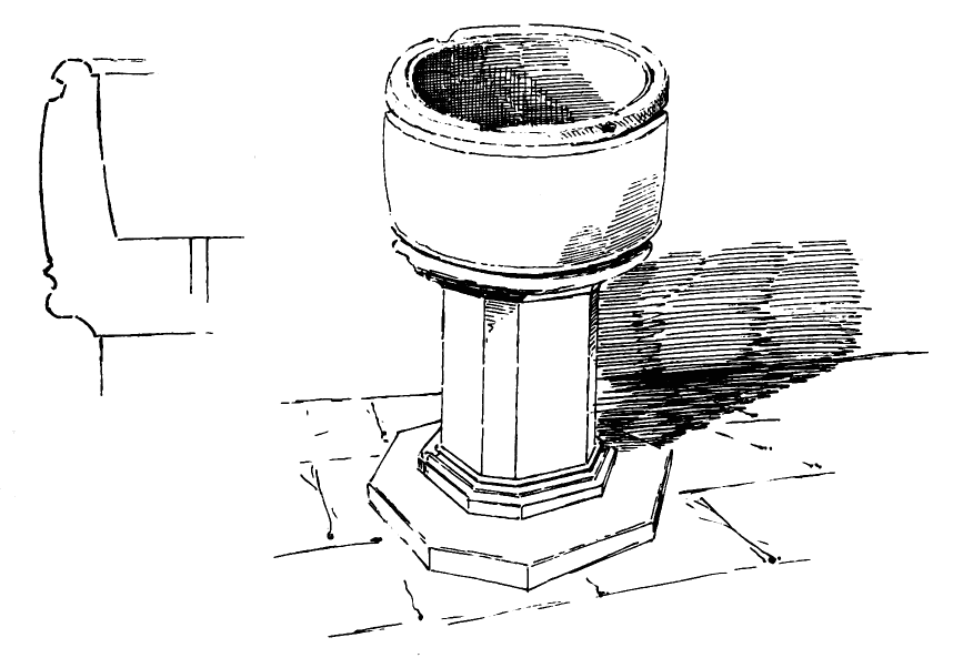
Fig. 736.—Gogar Church. Font, with Section.
THE ABBEY OF INCHCOLM, Fifeshire.
An account of this abbey is given in The Castellated and Domestic Architecture of Scotland,[121] in connection with its occupation by the English, in the time of Henry VIII., as a fortification. But being an important ecclesiastical structure, and in some respects a unique one, it is thought desirable to give it a place in this volume, with some additional particulars and illustrations.
The Island of Inchcolm, or Æmonia, as it was originally called, is believed to have formed the cradle of religion in the East of Scotland, as the more famous Iona did in the West; and it is thought that the first seeds of religion were implanted in it by St. Columba himself. In early times the founders of Christianity loved to establish themselves on islands, and in the Frith of Forth ecclesiastical remains are found not only at Inchcolm, but also on Inchkeith, the Bass, the Isle of May, and the Island of Fidra.
Like Iona, the Island of Inchcolm became especially celebrated as a place of burial, and large sums were paid for the privilege of interment on the island. This circumstance is referred to in Macbeth,[122] in connection with the defeat of “Sweno, Norway’s King”—
“Nor would we deign him burial of his men Till he disbursed at St. Colm’s Inch Ten thousand dollars to our general use.”
The island appears to have been inhabited up to the twelfth century by a Columban hermit. Fordun narrates that the abbey owes its foundation to Alexander I., who, in 1123, was driven ashore on the island by a storm, where he and his followers were maintained for three days by the hermit who then made Inchcolm his retreat, and who divided with them his scanty fare of shellfish and the milk of one cow. In recognition of his safe delivery, Alexander founded and endowed a monastery, and brought to it Augustinian Canons from the abbey he had established at Scone. The monastery continued to prosper, and, in 1216, received a large addition to its possessions from Allan Mortimer, proprietor of the domain of Aberdour, on the mainland adjoining, who purchased the right of interment in the church by bestowing on the abbey one half of his estate.
It is from this period that the existing buildings began to be erected, and the construction probably went on for a considerable length of time thereafter. In 1265 Richard, Bishop of Dunkeld, built the new choir at his own expense. He was High Chamberlain in 1255-57, and, at his death in 1272, his heart was laid, according to Father Hay, in the wall of the new choir.
Although the island position of the monastery made it usually a safe retreat, it did not protect it from the attacks of the English fleet during the War of Independence. In 1335 it was harried by the English, who carried off the precious chalices and censers, crosses and chandeliers, relics, vestments, and images. The abbey was again attacked in 1336, and in 1384 the fleet of Richard II. plundered it and set it on fire. Some repairs were, doubtless, required thereafter, and we find that in 1402 the chapel of the Blessed Virgin, adjoining the south side of the choir, was founded by the Prior, Richard of Aberdeen, and Thomas Crawford, Canon of Inchcolm.
In 1418 Walter Bower, the editor and continuator of the Scotichronicon of Fordun, was appointed abbot, and carried out his literary work in the abbey.
As the period of the Reformation approached, the monastery seems to have fallen off, and in 1543 Abbot Henry resigned office, and the abbey was deserted.
After the battle of Pinkie, in 1547, the Duke of Somerset occupied Inchcolm as the best post for commanding the Frith of Forth.
The lands of West Aberdour were acquired from Abbot Nicholas by James Stewart of Ochiltree, who became Commendator of the Abbey; and his second son, James Stewart, Lord Doune, was, in 1611, created a peer, with the title of Lord St. Colm. He married the daughter of the Regent Murray, and the lands were united to the estate of the Earl of Moray, who thus became proprietor of Inchcolm.
The island is about half a mile in length, and lies about one mile and a-half from the harbour of Aberdour, on the north side of the Frith of Forth. It consists of an elevated portion at each end, with a low lying isthmus between them, on which the abbey is built, the buildings extending across the full breadth of the land.
Notwithstanding the many attacks and injuries the structure has sustained, its remote situation has preserved the monastic buildings in a more complete state than in most of our old abbeys. The edifice, as it now stands (Fig. 737), consists of the usual cloister court (about 45 feet square), having the church on the north side and the chapter house beyond the east range. The monastery has the remarkable peculiarity of having had the buildings surrounding the cloister constructed so as to contain on the ground floor nothing but the cloister walk, and on the upper floor, above the ambulatory, the refectory, dormitory, and other domestic apartments of the canons. The cellars, stores, and other offices have been erected in a wing to the south-east. A detached building to the north of the church, now in ruins, was possibly the infirmary. To the west of the monastery lay the garden, which is enclosed with a wall. The well, which is sunk on the south of the garden, is built round with ashlar, is 50 feet deep, and contains a supply of good fresh water. A strong retaining wall runs along the north side of the buildings next the sea, and encloses the monastery on that side.
A very interesting relic of the original eremitical occupation of the island still survives at the north-west angle of the garden. This is a small cell covered with a pointed vault, the true importance of which was first pointed out by the late Sir James Y. Simpson,[123] who drew attention to it as the cell of the Columban recluse who occupied Inchcolm at or before the unexpected visit of Alexander I. It consists (Fig. 738) of an irregular stone building, measuring internally 15 feet 7 inches in length on the north side and 17 feet on the south side, by a width of 6 feet at the east end and 5 feet at the west end. The height from the floor to the spring of the arch is 4 feet 8 inches, and to the crown of the arch 8 feet. The cell is covered with a pointed barrel vault, the arch of which is composed of radiating stones, and is covered with stone flags, which form a curved roof on the exterior. The form of the arch indicates that the vault is not of the most ancient type of Celtic building, in which the arch consisted not of radiating, but of overlapping, stones pushed out horizontally over each other till they met with a flat stone in the centre.[124] The doorway, however, which is at the south-west angle, presents on the interior some appearance of the latter form of construction (Fig. 739),[125] while on the exterior (Fig. 740) it is formed with a round radiating arch. There is one small square-headed window in the east end, 13 inches in width and 24 inches in height, the jambs of which are in single stones, without moulding or chamfer. In the south wall there is a rude ambry, 12 inches wide and 17 inches deep.
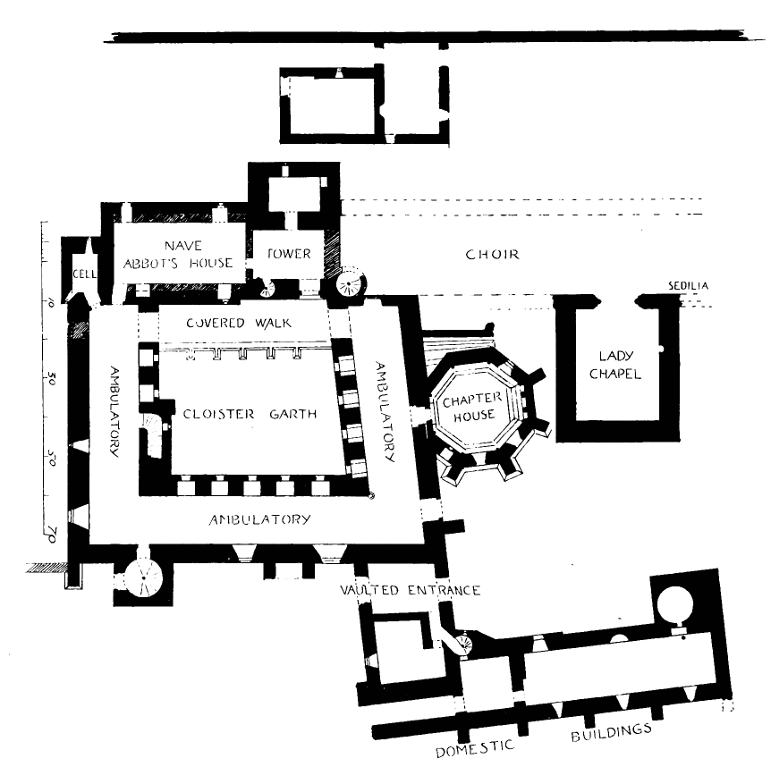
Fig. 737.—The Abbey of Inchcolm. Plan of Ground Floor.
This cell has, doubtless, been often repaired (indeed, it requires some repair now), and it is possible that the vault and stone roof may not be the original ones; but the walls are certainly ancient, and the structure is very interesting from its being one of the very few relics of the Columban church which survive in the eastern part of Scotland.
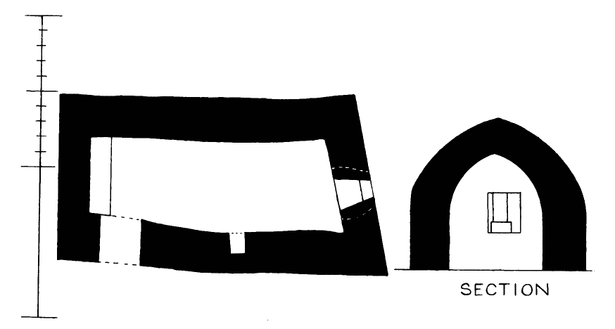
Fig. 738.—The Abbey of Inchcolm. St. Colm’s Cell: Plan and Section.
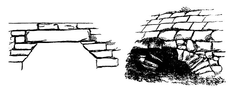
Fig. 739.—The Abbey of Inchcolm. Horizontal Arch of the Door, as seen from within the Cell. Fig. 740.—The Abbey of Inchcolm. Exterior Arch of the Doorway.
As above pointed out, the abbey buildings are of different periods, and have evidently been subjected to several alterations at different times. The church appears to be the oldest part of the edifice. It has originally consisted (see Fig. 737) of a nave, internally 35 feet in length by 20 feet in width; a central tower, 24 feet long by 22 feet wide
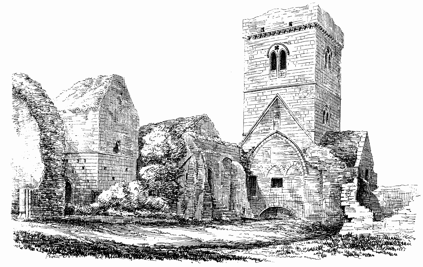
Fig. 741.—The Abbey of Inchcolm. View from North-East.
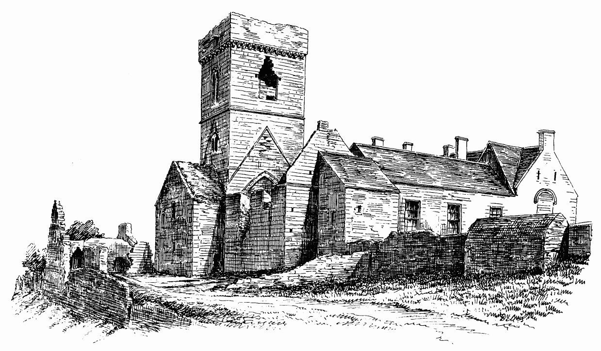
Fig. 742.—The Abbey of Inchcolm. View from North-West.
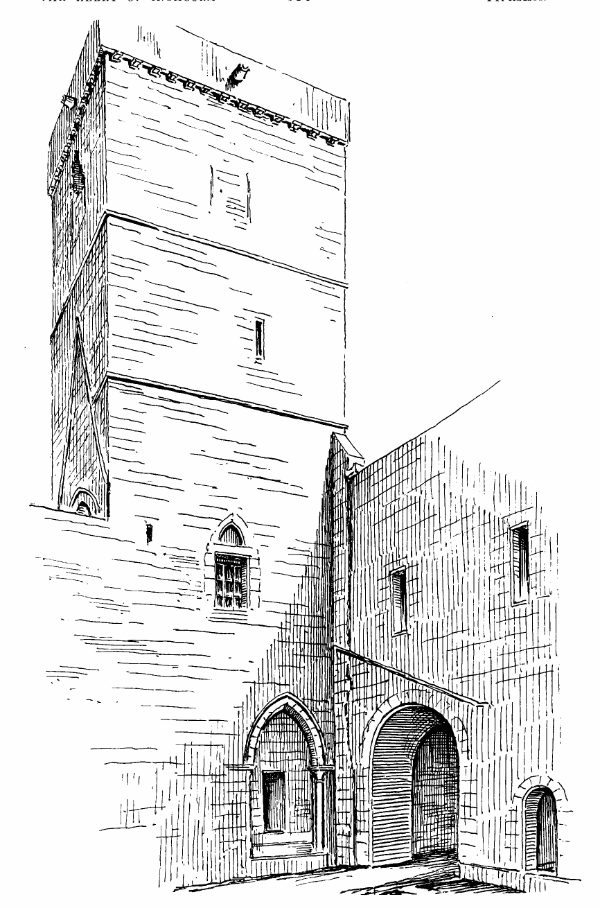
Fig. 743.—The Abbey of Inchcolm. North-East Angle of Cloister.
externally; and a choir to the east of the tower, of which a fragment survives, but which was subsequently superseded by a new choir. The church was lofty as compared with its width, as is apparent from the high pointed arches (Figs. 741 and 742) in the east and west walls of the tower. It is not now discoverable how the nave and choir were roofed, but from the absence of buttresses, and the built water tables in the tower with steep slope, the roof was most probably of timber. Over the arch leading from the tower to the choir there is a doorway (see Fig. 741), which gave access to a chamber in the roof. The church was entered from the cloister by a high pointed doorway (Fig. 743) in the south wall of the tower. Adjoining this, in the south wall, a wheel stair led to the upper stories of the tower. The nave has been much altered, but still retains along the north side an early trigonal string course. The south doorway and other details of the tower also indicate a date early in the thirteenth century (see the details of the doorway in Fig. 750). The tower (see Figs. 741 and 742) rises to two stories above the church roof, and contains windows, each having two smaller arches enclosed within a round arch, and having the spandrils pierced with simple quatrefoil openings. The parapet is supported by first pointed corbels (Fig. 744). In each of the north and south walls of the tower there was originally, at the level of the church, a single pointed lancet window, the upper part of which has in each case been preserved, although greatly altered at a later date. The upper part of the south window is visible in Fig. 743; and a similar portion of the north window is preserved over the door to the transept. The tower had simple buttresses at the angles, one of which is still preserved on the south side (see Fig. 743), where it has been incorporated with the later cloisteral structures, while the other buttresses have been altered. A fragment of the original choir also still survives in a portion of the south wall, which has been incorporated with the later building of the dormitory to the south. This fragment still retains, though built up, the plain round arch of a small window, and its large, round sconsion arch—the former now looking into the dormitory (Fig. 745), and the latter being visible in the interior of the choir (see Fig. 741). This window is, doubtless, of the period of the tower and nave. It has formed part of the exterior south wall of the choir, thus showing that the space opposite it was open, and that the dormitory, which is on the first floor, and blocks it up, has been added at a later period.
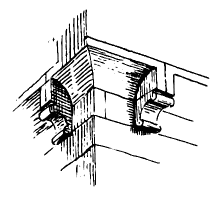
Fig. 744. The Abbey of Inchcolm. Corbels of Parapet of Tower.
What the original form of the cloister buildings may have been it is now difficult to determine. As has been pointed out above, their arrangement is very unusual, the cloister walk occupying the whole of the ground floor, and the domestic buildings being on the first floor. This arrangement is quite contrary to that generally adopted, the usual plan being to have a one-story cloister walk round the court, giving access on the ground floor to the sacristy, chapter house, &c., in the east range, to the refectory in the south range, and to the cellars, &c., in the west range. At Inchcolm the ambulatory, or cloister walk—about 15 feet wide—occupies the whole of the ground floor round the east, south, and west sides of the square, while the church stands on the north side. This arrangement would be somewhat awkward as regards the principal entrance to the church through the tower, which would be left in the open court without any covered way leading to it. An attempt has been made at a late date to obviate this drawback by continuing a one-story cloister walk round the north side of the court (see Fig. 737).