Chapter IX
Reading edition
THE MOVEMENTS AND DEFORMATIONS OF THE EARTH’S BODY (DIASTROPHISM).
The body of the earth is subject to an infinite variety of movements, ranging from the almost inconceivably rapid to the almost imperceptibly slow, and from the almost immeasurably minute to the enormously massive; but, for practical treatment, they fall mainly into two couplets: (1) the minute and rapid, and (2) the slow and massive. Sudden movements of local masses, giving rise to intense vibrations, are put in the first class. There are innumerable minute and slow movements, but unless they rise to appreciable magnitude by long continuance, they are neglected.
MINUTE AND RAPID MOVEMENTS.
The crust of the earth is in a state of perpetual tremor. For the most part, these tremors are too minute to be sensible, but are revealed by delicate instrumental devices. Some of them are but the declining stages of sensible vibrations, but others are minute from their inception. Many of them spring from the ordinary incidents of the surface, and claim attention chiefly as obstacles to the study of more significant oscillations. Winds, waves, waterfalls, the tread of animals, the rumble of traffic, the blasts of mines, the changes of temperature, the variations in atmospheric pressure, the weighting of rainfall and the lightening of evaporation, the rupture of rock or ice or frozen earth, and many other processes, make their contributions to local and minute movements. For the greater part, these vibrations are superficial in origin, and are soon damped beyond recognition by dispersal and by the inelastic and discontinuous nature of the looser material of the surface. When a temporary rigid crust is formed by freezing, as in winter, these surface vibrations are transmitted with much less loss, and the distances at which the rumble of winter traffic is heard, is a good illustration of the function of continuity and solidity in the conveyance of vibrations.
Earthquakes.
When the tremors spring from sources within the earth itself and are of appreciable violence, they are recognized as earthquakes. The sources of earthquake tremors are various. The most prevalent is probably the fracture of rocks and the slipping of strata on each other in the process of faulting. The interpretation of movements of this class has now been so far perfected that the length and depth of the fault, the amount of the slip, and the direction of the hade are capable of approximate estimation.[224] To the same class belong the movements due to slumping. They are illustrated by the sliding and arrest of great masses of sediment along the steep fronts of deltas, and of the accumulations of deep-sea oozes on steep submarine slopes. Such slumping is, in reality, superficial faulting. Seismic tremors often attend volcanic eruptions, and are then probably attributable to the sudden fracture and displacement of rock by the penetration of lava, or by rapid and unequal heating. They are perhaps also due sometimes to the sudden generation or cooling of steam in underground conduits, crevices, and caverns, the action possibly being in some cases of the “water-hammer” type. In rare instances, probably, the bursting of beds overlying pent-up non-volcanic gases may give origin to earthquakes. A more superficial source of earthquake vibrations is the collapse of the roofs of subterranean caverns.
Seismic vibrations seem to be in part compressional, in part distortional, in part (on the surface) undulatory, and in part irregular. The distortional are especially significant, as they seem to imply a solid medium of transmission.
Points of origin, foci.—It is probable that nearly or quite all earthquake movements start within the upper ten miles of the crust, and most of them within the upper five. Some of the earlier estimates indeed placed the points of origin as deep as 20 or 30 miles, but in these cases the necessary corrections, discussed below, were neglected. Most of the recent and more accurate estimates fall within the limits given.
The method of estimating the depth of the centers of disturbance consists in observing the directions of throw or thrust of bodies at the surface, and in regarding these as representing the lines of emergence of the earthquake-waves. By plotting these lines of emergence, and projecting them backwards to their underground crossings, a first approximation to the location of the focus is reached (the lines EF′, Fig. 446). From the nature of the case, the observations of the angles of emergence cannot be very accurate, but an effort is made to limit the error by making the number of observations great.
Two systematic corrections are to be applied to all such estimates, the one for varying elasticity and density, and the other for varying continuity. Both reduce the estimated depth. In making the correction for varying elasticity, it must be noted that the velocity of vibrations varies directly as the square root of the elasticity, and inversely as the square root of the density. The velocity is also accelerated by increase of temperature. The elasticity, temperature, and density all increase with depth. Theoretically, the increase of velocity due to the increasing elasticity and temperature of increasing depths, overbalances the retardation due to increasing density, and recent observations on the transmission of seismic waves through deep chords of the earth have confirmed this conclusion. The path of the vibration will, therefore, be curved toward the surface, as pointed out by Schmidt and illustrated in Fig. 446, taken from his discussion.[225] From this it is clear that the focus is not so deep as implied by the simple backward projection of the lines of emergence.
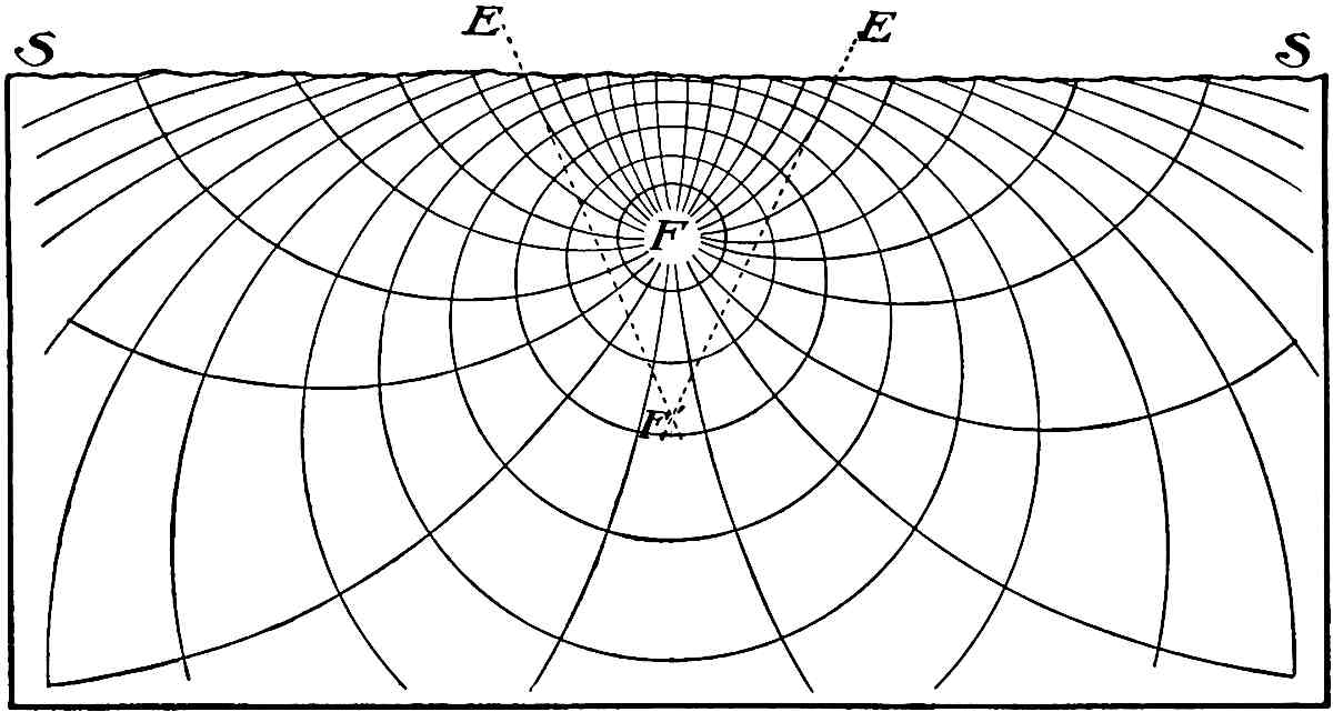
Fig.
446.—Diagram illustrating by closed curves the different rates of propagation of seismic tremors from a focus
F
, and, by lines normal to these, the changing directions of propagation of the wave-front. It will be seen that the paths of propagation curve upwards in approaching the surface. If the lines of emergence, as at
E
and
E
, be projected backwards, as to
F′
, the points of crossing will be below the true focus.
A second correction must be made for the differences of continuity of the upper rock in the vertical and horizontal directions. In the outer part of the earth, the continuity in horizontal directions is interrupted by vertical fissures. Were these not usually filled with water, they would soon kill the horizontal component of the seismic wave, and the residual portion would be directed almost vertically to the surface, for the width of the fissures is almost always greater than the amplitude of the seismic vibrations. The water restores the continuity, in a measure, but not perfectly, for the elasticity of water is much less than that of rock. It is clear that in horizontal movement there must be a constant transfer from rock to water and from water to rock, and this must retard, as well as partially destroy, the vibrations. In a vertical direction, however, the rocks rest firmly upon one another, and this gives measurable continuity, the only change being from one layer or kind of rock to another. It seems certain, therefore, that the vertical component of the seismic wave will be less damped and less retarded in transmission than the horizontal. It will, therefore, reach the surface sooner and will have the greater effect on bodies at the surface, not only for the reasons given, but also because it emerges more nearly in the line of least resistance and of freest projection. On this account, a second correction must be added to the correction for elasticity, and this must further reduce appreciably the first estimate of the depth of the focus.
Observation shows that in some way a seismic wave becomes separated in transmission into portions of different natures and speeds, but their interpretation is yet uncertain. These separated portions probably consist of the compressional, the distortional, and the undulatory waves, and perhaps of refractions and reflections of these (see Fig. 448).
A most important recent achievement is the detection and investigation of seismic tremors that appear to have come through the earth. The transmission of such waves promises to reveal much relative to the nature of the deep interior, when enough data are gathered to warrant conclusions. The rate of propagation in the central parts is found to be greater than in the outer parts, implying high elasticity within.
The amplitude of the vibrations.—From the very disastrous effects of severe earthquakes, it is natural to infer that the distinctive oscillations must have large amplitude, but in fact it is the suddenness of the vibration, rather than its length, that is effective. Instrumental investigations indicate that the oscillations, after they have left their points of origin, are usually only a fraction of a millimeter in amplitude; at most they seldom exceed a few millimeters. A sudden shock with an amplitude of 5 or 6 millimeters is sufficient to shatter a chimney. It is true that estimates assigning amplitudes of a foot or more have been made, but their correctness is open to serious doubt. It should be understood that it is the length of oscillation of the particles of the subsurface rock transmitting the vibrations that is referred to, not the movement of the free surface, or of objects on the surface. The throw at and on the surface is much greater. Just as a slight, quick tap of a hammer on a floor is sufficient to make a marble lying on it bound several inches, so a sufficiently sudden rise of the surface of the earth, though but a fraction of an inch, may project loose bodies many feet.
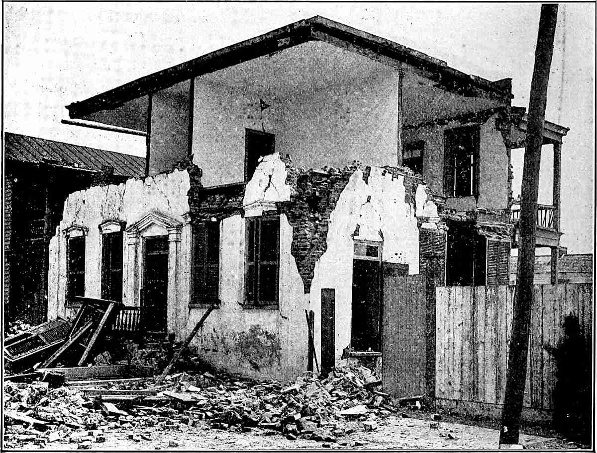
Fig.
447.—Illustration of the destructive effects of the Charleston earthquake, showing definite direction of throw. (W. J. McGee.)
Destructive effects.—The interpretation of the disastrous results of earthquake shocks has, therefore, its key in the suddenness and strength of rather minute vibrations of the earth-matter, but it is also dependent on the freedom of motion of the bodies affected. The rocks of the deeper zones, where the matter is sensibly continuous, transmit the seismic vibrations without appreciable disruptive effect, so far as known, though the origin of crevices has been assigned to this cause; but bodies at the surface are fractured, overturned, and hurled from their places. The reason is doubtless this: Within a great mass firmly held in place by cohesion and pressure on all sides, the forward motion of a particle develops an equal elastic resistance, and it is quickly thrown back again and the wave passes on. At the surface, where bodies are freer to move, the stroke of the vibration projects the body, and so, instead of vibratory resilience, the chief energy is converted into mass-motion. The tap of a hammer sends an almost imperceptible vibration along the floor, but this vibration may throw a glass ball, beneath which it runs, into the air. So the minute vibrations of earth-matter may travel miles from their origin through continuous substance with little result, and then so suddenly thrust a loose body on the surface, or the base of a column, or the foundation of a house, as to rack it with differential strains, or even to hurl it to destruction. So, too, earth-waves striking the sea-border may thrust the waters off shore by their sudden impact, and the reaction may develop a wave which overwhelms the coast. Such waves may doubtless arise from a sudden stroke of seismic vibrations on the sea-bottom. The great gaping fissures that sometimes open during earthquakes occur oftenest where the surface on one side is less well supported than on the other, as on a slope, or near a bluff-face or a river-channel. When in such situations the earth is once suddenly forced in the direction of least resistance, it is not always met by sufficient elastic resistance to throw it back. Sometimes, however, there is an elastic return, and the fissure closes forcibly an instant after it is opened.
Direction of throw.—Immediately above the point of origin, technically the epicentrum or epi-focal point, bodies are projected upwards. When crushing takes place in such a case, it is due to the upthrust or to the return downfall. At one side of the epicentrum the thrust is oblique in various degrees, and is usually more destructive, if not too far from the epicentrum. The destructiveness commonly increases for a certain distance from the epi-focal point, and then diminishes. Under ideal conditions, the greatest effects are found where the vibration emerges at an angle of about 45°, but various influences modify this result. Lines drawn through points of equal effect (isoseismals) are not usually regular circles or ellipses about the epicentrum, as they would be under ideal conditions. The various divergencies represent differences of effective elasticity, of surface, and of other influences. As most earthquakes originate from lines, planes, or masses, rather than points, there are doubtless differences of intensity of vibration at different points on the lines, planes, or areas of origin, and these differences introduce inequalities in propagation and in surface effects.
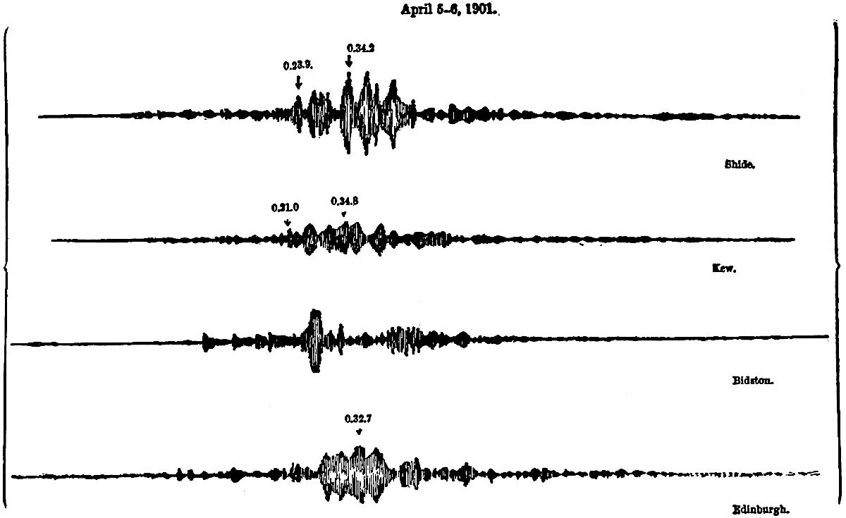
Fig.
448.—Illustrations of the records made by earthquake tremors after distant transmission through the earth. The four diagrams represent the same set of tremors as received at Shide, Kew, Bidston, and Edinburgh in Great Britain. The movement was from left to right. (Milne.)
Rate of propagation.—The progress of a seismic wave varies very greatly. Both experimental tests and natural observations give very discordant results. At present, they justify only the broad statement that the velocity of propagation varies from several hundreds to several thousands of feet per second at the surface. The rate seems to be greater for strong vibrations than for weak ones, and hence it is faster near the origin than farther away. The strength of a vibration dies away, theoretically, according to the inverse square of the distance from the point of origin. Practically there is to be added to this the partial destruction of the vibrations by conversion into other forms of motion.
Sequences of vibrations.—Near the source, the main shocks are apt to come suddenly and to be followed by minor tremors. At a distance there are usually “preliminary” vibrations followed by the main tremors, and these by others of gradually diminishing value. This development is assigned to different rates of propagation, and to refractions and reflections not unlike the prolongation of thunder (see Fig. 448). This deployment of the vibrations is notably developed in the shocks that pass long distances through the earth. The vibrations of the first phase are regarded as compressional, those of the second as distortional, while the largest oscillations which arise still later perhaps come around the surface, and may be undulatory, though their nature is not yet determined.
There is often, however, a true succession of original shocks caused by a succession of slips or ruptures at the source. Sometimes these are exceedingly persistent, running through days, weeks, or even months. In such cases a slow faulting is probably in progress, and little slips and stops follow in close succession. In one instance as many as 600 shocks in ten days have been reported.[226]
Gaseous emanations.—Vapors and gas frequently issue from earthquake rents, and are popularly made to serve as causes, but they are usually merely the earth gases that are permitted to escape by the rending of the ground, or are forced out by readjustment of the shaken beds. Like other subterranean gases, they are often sulphurous, and they are sometimes hot, especially in volcanic regions. Where the shocks are connected with eruptions, the gases may be truly volcanic.
Distribution of earthquakes.—Over large portions of the globe, severe earthquakes are exceedingly rare, but in certain regions they are unfortunately frequent. For the most part, these are volcanic districts, but this is by no means a universal relation. Earthquakes and volcanoes are only in part associates. In general, it may be said that earthquakes are frequent where geologic changes are in rapid progress, as along belts of young mountains, where the stresses are not yet adjusted, or at the mouths of great streams, where deltas are accumulating, or about volcanoes, where temperatures and strains are changing, or on the great slopes, particularly the submarine slopes, where readjustments in response to inequalities of surface stress are in progress. Not a few, however, occur where the special occasion is not at all obvious.
The Geologic Effects of Earthquakes.
Earthquakes are of much less importance, geologically, than many gentler movements and activities. Disastrous as they sometimes are to human affairs, they leave few distinct and readily identifiable marks which are more than temporary.
Fracturing of rock.—During the passage of notable earthquake waves, the solid rock is probably often fractured (see p. 509), though where it is covered by deep soil the fractures are rarely observable at the surface. Elsewhere the crevices are readily seen, especially if they gape. In a few instances surface-rock has been seen to be thoroughly shattered after the passage of an earthquake, as in the Concepcion earthquake of 1835.[227] Joints which were before closed are often opened during an earthquake. Thus in northern Arizona, not far from Canyon Diablo, there is a crevice traceable for a considerable distance, which is said to have been opened during an earthquake. Locally, it gaps several feet. Other notable earthquake fissures have been recorded in India,[228] Japan, and New Zealand. During an earthquake which shook the South Island of New Zealand in 1848, “a fissure was formed averaging 18 inches in width, and traceable for a distance of 60 miles, parallel to the axis of the adjacent mountain chain.”[229] The development of fractures or the opening of joints is sometimes accompanied by faulting. This was the case in Japan during the earthquake of October 28, 1891, when the surface on one side of a fissure, which could be traced for 40 miles, sank 2 to 20 feet. In this case there was also notable horizontal displacement, the east wall of the fissure being thrust locally as much as 13 feet to the north.[230]
Changes of surface.—Circular surface openings or basins are sometimes developed during earthquakes. This was the case during the Charleston earthquake of 1886,[231] and similar effects have been noted elsewhere. These openings often serve as avenues of escape for ground-water, gases, and vapor. They are commonly supposed to be the result of the collapse of caverns, or other subterranean openings, the collapse often causing the forcible ejection of water. Such openings are likely to be formed only where the surface material is incoherent. Sandstone dikes (p. 514) may perhaps be associated in origin with earthquakes.
Earthquakes are likely to dislodge masses of rock in unstable positions, as on slopes or cliffs. They may also occasion slumps and landslides.[232]
Effects on drainage.—The fracturing of the rock may interfere with the movement of ground-water. After new cracks are developed, or old ones opened or closed, the movement of ground-water adapts itself to the new conditions. It follows that springs sometimes cease to flow after an earthquake, while new ones break out where there had been none before. The character of the water of springs is sometimes changed, presumably because it comes from different sources after the earthquake. Joints may be so widened as to intercept rivulets, and the waters thus intercepted may cause the further enlargement of the opening. Illustrations of this sort are furnished by the earthquakes of the Mississippi valley (Lat. 36° to 38°) in 1811–12. Where faults accompany earthquakes, they occasion ponds or falls where they cross streams. Illustrations of both were furnished by the Chedrang River of India after the earthquake of 1897.[233]
Effects on standing water.—Some of the most destructive effects of earthquakes are felt along the borders of the sea. Thus the great sea-wave of the Lisbon earthquake (1755) and that of the earthquake which affected the coasts of Ecuador and Peru in 1868 are examples. Such waves have been known to advance on the land as walls of water 60 feet in height. They are most destructive along low coasts, for here the water may sweep much more extensively over the land. The great loss of life during an earthquake has usually been the direct result of the great waves. Lakes are also affected by earthquakes, their waters sometimes rising and falling for several hours after the initial disturbance, but lake-waves are much feebler than those of the sea, and are not often destructive.
Earthquake shocks are sometimes remarkably destructive to the life of lakes and seas. Thus during the Indian earthquake of 1897, “fishes were killed in myriads as by the explosion of a dynamite cartridge ... and for days after the earthquake, the river (Sumesari) was choked with thousands of dead fish ... and two floating carcasses of Gangetic dolphins were seen which had been killed by the shock.”[234] This wholesale destruction of life is of interest, since the surfaces of layers of rock, often of great age, are sometimes covered with fossils of fish or other animal forms, so numerous and so preserved as to indicate that the animals were killed suddenly and in great numbers, and their bodies quickly buried. It has been suggested that such rock surfaces may be memorials of ancient earthquake shocks.[235]
Changes of level.—Permanent changes of level sometimes accompany an earthquake. Thus after the earthquake of 1822 “the coast of Chili for a long distance was said to have risen 3 or 4 feet.”[236] Similar results have occurred on the same coast at other times, and on other coasts at various times. Depression of the surface is perhaps even more common than elevation. Thus on the coast of India all except the higher parts of an area 60 square miles in extent were sunk below the sea during an earthquake in 1762. Widespread depression in the vicinity of the Mississippi in Missouri, Arkansas, Kentucky, and Tennessee accompanied the earthquakes of 1811 and 1812. Some of the depressed areas were converted into marshes, while others became the sites of permanent lakes. Reelfoot Lake, mainly in Tennessee, is an example. Change of level is involved wherever there is faulting, and faulting is probably rather common in connection with earthquakes.
Changes of level are not confined to the land. Where earthquake disturbances affect the sea-bottom in regions of telegraph cables, the cables are often broken. In such cases notable changes have sometimes been discovered and recorded when the cables were repaired. Striking examples are furnished by the region about Greece.[237] In one instance (1873) the repairing vessel found about 2000 feet of water where about 1400 feet existed when the cable was laid. In another instance (1878) the bottom was “so irregular and uneven for a distance of about two miles, that a detour was made and the cable lengthened by five or six miles.” In still another case (1885) the repairing vessel found a “difference of 1500 feet between the bow and stern soundings.” These records point to sea-bottom faulting on a large scale.
It is probably no nearer the truth to say that changes of level result from earthquakes than to say that earthquakes result from changes of level. The two classes of phenomena are probably to be referred to a common cause.[238]
SLOW MASSIVE MOVEMENTS.
It is a far cry from the intense and inconceivably rapid oscillations of the earthquake, to the excessively slow subsidences of continents, or even the slow wrinkling of mountain folds. Not infrequently rivers wear down their channels across a mountain range as fast as it rises athwart them. The movements of continents are even more deliberate. But, far apart as these contrasted movements are, in rate and method, they are associated in ultimate causation, and the earthquake shock is often merely an incident in the formation of a mountain range or in the subsidence of a continent.
The great movements are usually classed (1) as continent-making (epeirogenic) and (2) mountain-making (orogenic). They may also be classed as (1) vertical movements and (2) horizontal movements, and dynamically, as (1) thrust movements and (2) stretching movements. It is to be understood that these distinctions are little more than analytical conveniences, for continental movements are often at the same time mountain-making movements; vertical movements are usually involved in horizontal movements, and stretching usually takes part in the processes in which thrust predominates, and vice versa. But where one phase greatly preponderates, it may conveniently give name to the whole.
Present movements.—Critical observations on seacoasts show that some shores are slowly rising and some slowly sinking relative to the ocean-level. We do not certainly know what their movements are relative to the center of the earth; very possibly all may be sinking, one set faster than the other, the ocean-surface also going down at an intermediate rate. Theoretically, all might possibly be rising, one set faster than the other, the ocean also rising at an intermediate rate, though this is extremely improbable. One set may be actually rising relative to the center of the earth, and the other sinking, while the ocean-level is stationary, or nearly so. This is the way in which we are accustomed to interpret them. A general shrinkage of the earth, however, is probably going on, carrying down land-surface and sea-surface. It has been urged by Suess[239] that the general shrinkage is so great that the local upward warpings and foldings never equal it, and that the real movements are all downward, though in different degrees. This is probably the general fact at least. Over against this is the popular disposition to regard earth movements generally as “upheavals.” There is also a predilection for regarding the rigid land as moving and the mobile sea-level as fixed. In reality, the sea is an extremely adaptive body that settles into the irregular hollows of the lithosphere, and is shifted about with every warping of the latter. Whatever change affects the capacity of its depressions affects also the sea-level. If they are increased, the sea settles more deeply into them; if they are decreased, the sea spreads out more widely on the borders of the land. The one thing that gives a measure of stability to the sea-level is the fact that all the great basins are connected, and so an average is maintained. A warping down in one part of the sea-bottom may be offset by an upward warping somewhere else in the 72% of the earth’s surface covered by the ocean, and so it is only the sum total of all changes in the sea-bottoms and borders that effects the common level. Thus it happens that, notwithstanding its instability and its complete subordination to the lithosphere, the sea-level is the most convenient basis of reference, and has become the accepted datum-plane. If there were some available mode of measuring the distance of points from the center of the earth, it would give absolute data and absolute terms, and would reveal much that is now uncertain respecting the real movements of the surface. For convenience, however, since absolute terms are impracticable, the ordinary language of geology, which represents movements as upward and downward, according to their relations to the sea-level or to the average surface, will be employed. Notwithstanding this concession to convenience in the use of terms, it is of the greatest importance to form, and to constantly retain, true fundamental views.
Fundamental conceptions.—The existence of any land at all is dependent on the inequalities of the surface and of the density of the lithosphere, for if it were perfectly spheroidal and equidense, the hydrosphere would cover it completely to a depth of about two miles. Not only are inequalities necessary to the existence of land, but these inequalities must be renewed from time to time, or the land area would soon, geologically speaking, be covered by the sea. The renewal has been made again and again in geological history by movements that have increased the inequalities in the surface of the lithosphere. With each such movement, apparently, the oceans have withdrawn more completely within the basins, and the continents have stood forth more broadly and relatively higher, until again worn down. This renewal of inequalities appears to have been, in its great features, a periodic movement, recurring at long intervals. In the intervening times, the sea has crept out over the lower parts of the continents, moving on steadily and slowly toward their complete submersion, which would inevitably have been attained if no interruption had checked and reversed the process. These are the great movements of the earth, and in them lies, we believe, the soul of geologic history and the basis for its grand divisions. The reasons for this will appear as the history is followed, and its most potential agencies are seen unfolding themselves. At the same time, there have been numerous minor surface movements in almost constant progress. While these two classes of movements have been associated, and are perhaps due in the main to the same causes, they are sufficiently different in some of their dynamic aspects to be separated in treatment.
Nearly Constant Small Movements.
Innumerable gentle warpings have affected nearly every portion of the surface of the globe at nearly all stages of its history. Not only during the periods of great movements were there countless minor and gentler movements, but at times of relative quiescence there were slow swellings and saggings of the surface of the lithosphere. They sometimes affected small areas and sometimes large ones, and they were sometimes of upward phase and sometimes of downward. They were the immediate agencies in locating and controlling the deposition of stratified rocks, though they rest back on the great movements for their working conditions. Very slow sinkings of sea-borders have permitted deposition to go on in shallow water for long periods without being interrupted by the local filling of the sea. Very slow swellings of land tracts, relative or absolute, have permitted erosion to supply material for such sedimentation for long periods without exhausting the sources. Very slow upward warpings in one region and downward warpings in another have shifted the borders of the land and sea, and with them the areas of erosion and deposition. Thus have arisen overlaps and unconformities of strata and diversities in their distribution from stage to stage. Such movements may have amounted to a few inches, or a few feet, or a few fathoms per century. Downward movements have sometimes affected a considerable section of a continent, letting in a shallow epicontinental sea upon it, such, for example, as the North Sea upon the northwestern border of the continent of Europe, and Hudson Bay upon the northeastern part of North America. Similar movements seem to have extended the seas even more widely upon the surface of the land in times past, as attested by the great transgressions of the ocean-borders and the great epicontinental spread of strata. Notwithstanding their great breadths, the epicontinental seas were generally shallow. Similar gentle warpings of upward phase rescued the bottoms of shallow seas from submersion, and inaugurated erosion; or they bowed base-leveled lands upward, and rejuvenated their streams and inaugurated a new cycle of denudation. Often they connected continents previously separated by shallow straits, and thus inaugurated inter-continental migrations of land life, while they stopped inter-oceanic migration.
The gentleness and frequency of these movements is attested by the character of the sediments and by their relations to one another, as will be seen in the study of the sedimentary series.
Reciprocal features.—These minor warpings show a notable tendency to be reciprocal. If one area is bowed up, another near by is bowed down. If the continents settle, the oceans rise on their borders. If the land is cut down, the sea is filled up. There is an important phase of this deserving especial note. Certain tracts have been slowly bowed upwards into long land swells, the streams being rejuvenated and degradation hastened. Adjacent tracts have been slowly bowed downwards into long parallel troughs which received the wash from the adjacent swells, and thus became tracts of exceptional sedimentation. Such a tract of parallel swell and sag, if our interpretation be correct, developed along the Atlantic border of North America in the Paleozoic era. By the slow upward warping of the swells, the feeding-grounds of the streams were maintained, and the sags were filled about as fast as they sank. Thus a great depth of sediment was laid down in the course of an era measured by millions of years. So in other regions, especially near the borders of the continents, there have been similar reciprocal movements, giving at once feeding-grounds for the streams and lodgment-grounds for the sediments, side by side in parallel belts. It is a common view that these belts of deep sedimentation were the forerunners of mountain formation, and that they determined the formation of the mountains. In view of the grounds for doubting the efficiency of so superficial an agency in mountain formation, which will appear as we go on, it may be well to hold this view in abeyance, and to dwell on the reciprocal nature of the action, in which the upward bowing that gave the feeding-grounds is as vital a factor as the sagging that accommodated the sedimentation. It is important to recognize that in so far as the crust was weak enough to yield to these gentler forces, it was not strong enough to accumulate the great stresses necessary to form mountain ranges, and further, that in so far as the stresses were eased by the gentle warping, they could not be accumulated for the later work of mountain-folding. It is nevertheless probable that the conditions which located the gentle swelling and sagging also located the mountain-folding.
The Great Periodic Movements.
Mountain-forming movements.—Along certain tracts, usually near the borders of the continents, and at certain times, usually separated by long intervals, the crust was folded into gigantic wrinkles, and these constitute the chief type of mountains, though not the only type. The characteristic force in this folding was lateral thrust. The strata were not only arched, but often closely folded, and sometimes intensely crumpled. In extreme cases, like the Alps, the folds flared out above, giving overturn dips and reversed strata, as illustrated in the chapter on Structural Geology, pp. 501–511. In these cases there was an upward as well as a horizontal movement, for the folds themselves were lifted; but the horizontal thrust so much preponderated, and was so much the more remarkable, that the upward movement was overshadowed. It is well to note, however, that these mountain ranges are crumpled outward and not inward, as might be expected if they resulted simply from the shrinkage of the under side of a thin shell. The folds are sometimes nearly upright and symmetrical, and sometimes inclined and asymmetrical, as illustrated in the chapter referred to. Where the folds lean, the inference has been drawn that the active thrust came from the side of the gentler slope, the folds being pushed over toward the resisting side, and this seems to be commonly true. The original attitude of the beds, however, has much to do with the character of the folds.[240] By a slight change in the mode of thrust, sheets of paper may be so pushed as to lean forward or backward at pleasure. The leaning of the folds seems, therefore, a doubtful criterion for determining the direction of the active movement. Mountains of the thrust type usually consist of a series of folds nearly parallel to each other, the whole forming an anticlinorium.
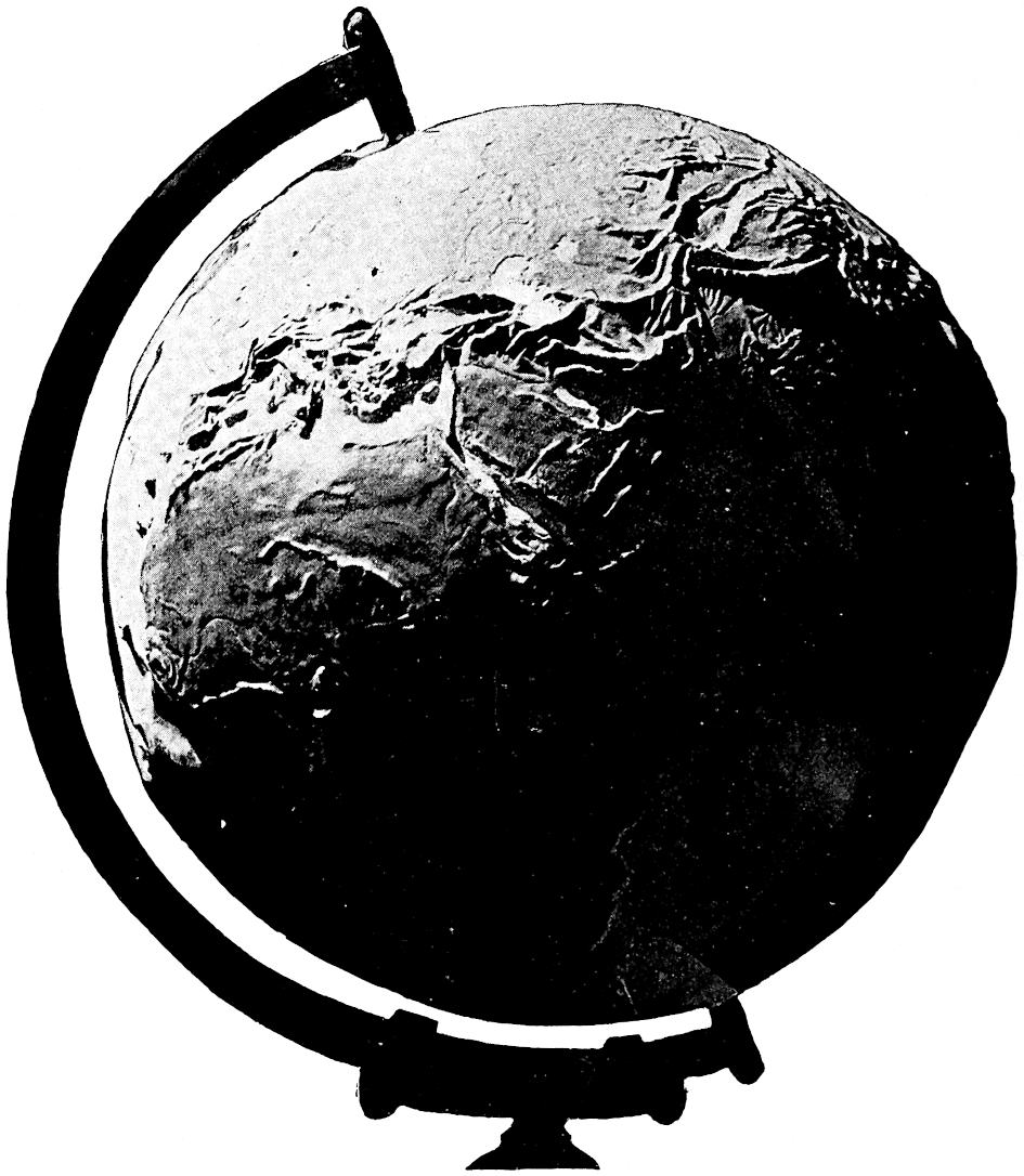
Fig.
449.—The great Eurasian mountain tract. Jones Relief Globe. (Photo. by R. T. Chamberlin.)
Distribution of folded ranges.—The prevailing location of this class of mountains is so generally near the borders of the continents that the relation is probably significant. Dana[241] long ago called attention to the fact that the greatest mountain ranges stand opposite the greatest ocean-basins, and he connected the elevation of the one with the depression of the other. One of the most notable exceptions to this relation is the complex system of southern Europe, from the Pyrenees to the Caucasus, and another is the Altai and connected ranges (Fig. 449). The Urals and not a few minor ranges are also exceptions. It is probably better to regard the crumpled tracts as lying on the borders of great segments of the earth that acted essentially as units, and to regard the relationship to the sea as a coincidence that is only in part causal.[242]
Plateau-forming movements.—Another leading phase of crustal movement is the settling or rising of great blocks of the crust, as though by vertical rather than horizontal force. The western plateau of North America and the great plateau of Thibet are gigantic examples. The American plateau embraces numerous blocks which, while they have been elevated together, are individually tilted in their own fashion. At the surface, they are separated by fault-planes, but below, some of them, and perhaps most of them, pass into flexures. Most of these flexures are of the monoclinal type (p. 516), which dynamically means much the same as a fault; but some of them may be of the compressive type, without inconsistency with vertical fault-relief above. Research has not yet covered thoroughly any great plateau, and knowledge of this class of movements is less complete than that of folding by lateral thrust, and it has a less ample place in the literature of the subject. The plateau-forming movements are, however, much more massive than the mountain-folding movements, and stand next in magnitude to the continent-forming movements. Plateaus may be regarded as smaller platforms superposed on the continental platforms.
In the ocean-basins, there appear to be raised platforms of the plateau type, and there are remarkable “deeps” that have the aspect of anti-plateaus.
Continent-forming movements.—True continent-forming movements appear to have antedated the earliest known sediments. As far back as we can read the sedimentary record, the continents seem to have been well established, and there is little evidence that they have since been fundamentally changed. It is true that some very eminent geologists have rather freely connected formations on one continent with formations having similar faunas on an opposite continent, by a hypothetical conversion of the intervening ocean-bottoms into land or shallow water; but most such faunal relations can be explained almost equally well by migration around the coasts, or at most by mere ridge-connections. The paucity, if not total absence, of abysmal deposits in the strata of the continents, taken with the persistence of terrestrial and coastal faunas, leaves little room for assigning an interchange of position between abysmal depths and continental elevations, and vice versa. Dynamic considerations also offer grave difficulties. The doctrine of the persistence of continents probably ought not to be pushed so far as to exclude shallow water, or even land, connections between South America, Antarctica, Australia, India, and South Africa, directly or indirectly, at certain stages of geological history. Without forming final conclusions as to the measure of the change which the continents have suffered during known geological history, it is safe to conclude that the continents and ocean-basins were in the main formed very early in the earth’s history, and that subsequent changes have consisted chiefly in the further sinking of the basins and the further protrusion of the land, save as the latter has been cut down by erosion. Incidentally, the ocean-basins have probably been extended and the continents restricted. On the other hand, the continents have been built out on their borders by wash from the land, and the waters of the ocean have been somewhat lifted by the deposition of sediment in their basins. It is estimated that the cutting away of the present continents, and the deposition of the material in the ocean-basins, would raise the sea-level about 650 feet. (R. D. George.)
Relations of these movements in time.—The folding movements seem to have had extraordinary prevalence in the earliest ages, for the Archean rocks are almost universally crumpled, and often in the most intricate fashion. There is no sign that the folding was then limited to the borders of the continents; it seems rather to have affected the whole continental surface. After the beginning of the well-known sedimentary series, crumpling appears to have taken place chiefly at long intervals, thus marking off great time-divisions, and to have been confined at any given stage to certain tracts, chiefly on the borders of great segments of the earth’s crust.
Concerning the plateau-forming movements in the past, knowledge is very meager, as the detection of plateaus of ancient times is more difficult than the detection of folds. Gentle warpings have apparently been in progress at all times.
Relations of vertical to horizontal movements.—The downward movements are unquestionably the primary ones, and the horizontal ones are secondary and incidental. The fundamental feature is doubtless central condensation actuated by gravity, and the master movements are the sinkings of the ocean-basins. The great periodic movements that made mountains and plateaus, and changed the capacity of the ocean-basins, probably started with the sinking of part or all of the ocean-bottoms. In the greater periodic movements, probably all the basins participated more or less, but some seem to have been more active than others. For example, in the last great mountain-making period, the Pacific basin seems to have been more active than the Atlantic, while in the similar great event at the close of the Paleozoic, the opposite seems to have been true. The squeezing up of the continents doubtless took place simultaneously with the settling of the basins. The true conception is perhaps that the ocean-basins and continental platforms are but the surface forms of great segments of the lithosphere, all of which crowd toward the center, the stronger and heavier segments taking precedence and squeezing the weaker and lighter ones between them. The area of the more depressed or master segments is almost exactly twice that of the protruding or squeezed ones. This estimate includes in the latter about 10,000,000 square miles now covered with shallow water. The volume of the hydrosphere is a little too great for the true basins, and it runs over, covering the borders of the continents. The amount of the overflow fluctuates from time to time, and may be neglected in a study of the movements and deformations of the lithosphere.
The squeezed segments.—The great protruding segments show a tendency toward rude triangularity. They are (1) the Eurasian, now strongly ridged on the south and east, and relatively flat on the northwest; (2) the African, rather strongly ridged on the east, but less abruptly elevated on the west and north; (3) the North American, now strongly ridged on the west, more gently on the east, and relatively flat at the north and in the interior; (4) the South American, strongly ridged on the west and somewhat on the northeast and southeast.
The foregoing form the major group. The minor group embraces (5) the Antarctic segment, not as yet sufficiently known to be well defined, and (6) the Australian, broadly reniform rather than triangular. To these are perhaps to be added (7) the largely submerged platform that stretches from Sumatra and Java on the southwest to the Philippines on the northeast, and is attached to India on the northwest; and (8) Greenland, which, though closely associated with North America, is partially separated by a rather deep depression.
The depressed or master segments.—The great sunken segments show a tendency to assume roughly polygonal, rather than triangular, forms. This accords with the primary place assigned them, since, in a spherical surface divided into larger and smaller segments, the major parts should be polygonal while the minor residual segments are more likely to be triangular. The major segments are (1) the Pacific, (2) the Indian, (3) the North Atlantic, and (4) the South Atlantic. These form the principal group, while (5) the Arctic deeps (not including the shallow epicontinental portions), (6) the Mediterranean, (7) the Caribbean, and (8) the chain of deep pits between the Philippine ridge and the Bornean platform, constitute a subordinate group.
Each member of the minor group is an irregular chain of depressed pits rather than a single continuous deep, unless the Arctic depression, of which little is now known, proves an exception. They lie between the greater segments at what may be conceived to be points of critical working relations, and are accompanied by small elevated blocks. The Caribbean, the Mediterranean, and the Bornean regions are the seats of the greatest present volcanic and related activities.
In a general view, there are then four great sunken quadrilaterals and four great elevated triangles, with minor attendants in each class. Lest fondness for simplicity and symmetry lead too far, we must hasten to observe that the dimensions are not alike in either class. The Pacific segment is more than twice the size of any other basin segment, and four times that of the North Atlantic. The Eurasian triangle is more than twice the average size of the other land segments, and nearly three times that of the South American. Nor is there any large common divisor of approximate accuracy. This is not at all strange if the earth be regarded as a body of somewhat heterogeneous composition which naturally shrank in rather irregular segments. On the other hand, this irregularity is somewhat strange if the earth has evolved from a very homogeneous and symmetrical, primitive, fluid state. It is also a serious consideration in any theory that appeals to crystalline form, or analogy, as in the doctrine of a tetrahedral earth.
Roughly approximated in millions of square miles, the major depressed segments are as follows: the Pacific, 60, the Indian, 27, the South Atlantic, 24, and the North Atlantic, 14, leaving 8 for minor depressions. The elevated segments are Eurasian, 24, African, 12, North American, 10, and South American, 9, leaving 10 for the minor blocks.
If these segments be regarded as the great integers of body-movement, two-thirds of them taking precedence in sinking and the other third in suffering distortion, it is easy to pass to the conception of sub-segments, moving somewhat differently from the main segments, so as to aid in their adjustment to one another, and thus to the conception of plateaus and deeps. It is easy also to pass to the conception of mutual crowding and crumpling at the edges of these segments, accompanied by fracture and slipping. These conceptions perhaps represent the true relations between the massive movements of the abysmal and continental segments, as well as the less massive plateau-forming movements and the mountain-forming distortions. The mountains and plateaus are probably the incidental results of the great abysmal and continental readjustments.
The great movements are probably to be attributed to stresses that gradually accumulated until they overcame the rigidity of the thick massive segments involved, and forced a readjustment. In accumulating these stresses, some local yielding on weak lines and at special points was an inevitable incident in distributing more equably the accumulating stresses. So, also, the first great readjustments probably left many local strains and unequal stresses which gradually eased themselves by warpings, minor faultings, etc., so that some minor movements were a natural sequence of the great movements. But there were doubtless many local and superficial causes, such as irregular gains and losses of heat, regional loading and unloading, solution, hydration, etc., that have caused local or regional movement, and which have little to do with the great deformations of the earth’s body. As implied above, the gentle, nearly constant movements probably fall mainly into a different category from the great periodic movements. Both will be considered further.
The differential extent of the movements.—Between the highest elevation of the land and the lowest depth of the ocean, there is a vertical range of nearly twelve miles. There may have been higher elevations, relatively, in past times, but probably not deeper depressions; and so, if we assume that the surface was once perfectly spheroidal, this may be taken as a maximum expression of differential movement, not absolute vertical movement. From the Thibetan plateau, where a considerable area exceeds three miles in height, to the Tuscarora deep, where a notable tract exceeds five miles in depth, the range is eight miles, which may fairly represent the vertical range of rather massive differential movement. From the average height of the continents to the average abysmal bottoms of the oceans the range is nearly three miles, which may be taken as the differential movement of the great segments. Under certain hypotheses of the origin and early history of the earth, to be sketched later, the surface is not assumed to have been perfectly spheroidal originally, and hence the present irregularities do not necessarily imply so great differential movement.
If the protruding portions of the lithosphere were graded down and the basins graded up to a common level, this level would lie about 9000 feet below the ocean-surface. This equated level is the best basis of reference for relative segmental movements. Referred to this datum plane, the continents, having an area about half as great as that of the ocean depths, have been squeezed up relatively about two miles, and the basins have sunk about one mile from the ideal common plane. The total downward movement, representing the total shrinkage of the earth, is quite unknown from observation. It is probably very much greater than the differential movement, as will appear from theoretical considerations as we go on.
The extent of the lateral movements has a peculiar interest, for it bears theoretically on the shrinkage of the earth. Every mile of descent of the crust represents 6 miles (6.28) shortening of the circumference. If the vertical movements were limited to the relative ones just named, the mile of basin descent would give but little more than 6 miles of surplus circumference for lateral thrust and crumpling. How far does this go in explaining the known facts? By measuring the folds of the Alps, Heim has estimated the shortening represented by them to be 74 miles.[243] Claypole estimated the shortening for the Appalachians in Pennsylvania, not including the crystalline belt on the east, at 46 miles;[244] McConnel placed that of the Laramide range in British America at 25 miles,[245] and LeConte that of the Coast range in California at 9 to 12 miles.[246] These estimates must be corrected for the thickening and thinning of the beds in the process of folding, for the composite character of the folds, and for the effects of shearing and faulting. These will in part tend to increase and in part to decrease the estimates. The first effect of horizontal thrust is to close up all crevices and compact the beds as much as they will stand without bending. A part of the unusual thickness which the beds of folded regions commonly show is probably due to this edgewise compression. In experiments on artificial strata made to illustrate foldings (Fig. 449a), the thickening of the layers is a very appreciable part of the process, though probably natural beds do not thicken in equal proportion. After the beds have been closely folded and the thrust is athwart them, they are thinned and stretched on the limbs of the fold. How far this and other causes of extension offset initial compression is undetermined, and is differently estimated. It seems highly probable from the nature of the case that the edgewise compression which resulted from sustaining the full stress before the beds bent, was much greater than the crosswise compression on the limbs of the folds, which came into action only after the stress had been largely satisfied by folding.
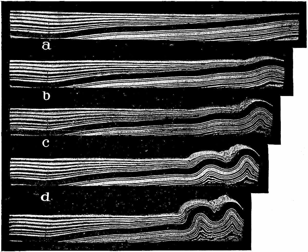
Fig.
449
a
.—Illustrations of Willis’ experiments in the artificial representation of mountain folding. The sections were formed of layers of wax of different colors, and were mechanically compressed from the right. The upper section shows the original state, and the offsets of the succeeding sections at the right indicate the amount of shortening. (Thirteenth Ann. Rep.
U. S.
Geol. Surv.)
Whatever the correction, and whatever the probable errors of the above estimates, the amount of shortening involved in folding is large. The estimates given are merely those for certain periods of folding, and represent only that portion of the compression of the circumference which was concentrated in a given mountain range. The whole shortening of a circumference is to be found by adding together all the transverse foldings on a given great circle, following it about the globe at right angles to a given folded tract. In so doing, it will be seen that the belt does not usually cross more than one or two strongly folded tracts of the same age, from which it is inferred that the shortening on each great circle was largely concentrated in a few tracts running at large angles to each other, to accommodate the shrinkage of the globe in all directions. If the folding in a main range crossing any great circle is doubled, it will probably represent roughly the shortening for that entire circle for that age. If one is disposed to minimize the amount of folding, the estimate may perhaps be put roundly at 50 miles, on an entire circumference, for each of the great mountain-making periods. If, on the other hand, one is disposed to give the estimates a generous figure so as to put explanations to the severest test, he may perhaps fairly place the shortening at 100 miles, or even more. For the whole shortening since Cambrian times, perhaps twice these amounts might suffice, for while there have been several mountain-making periods, only three are perhaps entitled to be put in the first order, that at the close of the Paleozoic, that at the close of the Mesozoic, and that in the late Tertiary. The shortening in the Proterozoic period was considerable, but is imperfectly known. The Archean rocks suffered great compression in their own times, and probably shared in that of all later periods, and if their shortening could be estimated closely, it might be taken as covering the whole. Assuming the circumferential shortening to have been 50 miles during a given great mountain-folding period, the appropriate radial shrinkage is 8 miles. For the more generous estimate of 100 miles, it is 16 miles. If these estimates be doubled for the whole of the Paleozoic and later eras, the radial shortening becomes 16 and 32 miles, respectively.
THE CAUSES OF MOVEMENT.
General Considerations.
The volume of the earth is at all times dependent on two sets of antagonistic forces, (1) the attractive or centripetal, consisting of gravity and the molecular and sub-molecular attractions, and (2) the resistant forces—which are not necessarily centrifugal—consisting of heat and the resistant molecular and sub-molecular forces.
1. The centripetal agencies.
Gravity.—The most obvious of the concentrating forces is gravity, and in most questions relating to great segmental movements, it has been thought sufficient to consider gravity alone, but it is by no means certain that this does not lead to serious error. In studying the causes and effects of earth movements, it is necessary to consider both gravitational energy and gravitational force. Gravitational energy is greatest when the mass is most widely dispersed, and least when most concentrated. Gravitational force is greatest when the mass is most concentrated, and least when most dispersed. The gravitational energy of the earth matter was at its maximum when it was most widely diffused in the supposed nebulous condition. It will perhaps reach its minimum at some future period when the shrinkage shall reach its limit. In passing from an expanded condition to a more concentrated condition, potential energy, or energy of position, is transformed into other forms of energy, chiefly heat. The heat thus developed is an important factor in the earth’s dynamics. The total amount of gravitational energy involved in the earth’s evolution is unknown, for neither the maximum dispersion of the earliest state, nor the ultimate condensation, is known. It is not difficult, however, to compute the amount of transformation of gravitational energy into heat, or other forms of energy, during a given degree of condensation. If a mass equal to that of the earth were originally infinitely scattered, the gravitational energy given up by it in condensing into a homogeneous sphere of the earth’s present size would, if all transformed into heat, suffice to raise the temperature of an equal mass of water 8900° C. (Hoskins), or an equal mass of rock (specific heat of .2), 44,500° C. If the mass were more condensed toward the center, as is the actual case, the heat would be considerably greater. If the condensation toward the center followed the Laplacian law (p. 564), the heat would be sufficient to raise the earth mass 48,900° C., assuming its specific heat to be .2, which is about the average specific heat of rock at the surface (Lunn). A further shrinkage of one mile would transform an additional amount of gravitational energy into heat about equal in amount to Tait’s estimate of the loss of heat from the surface of the earth in 100,000,000 years (see p. 572). If the radial shrinkage has been 32 miles, or even 16 miles, the amount of heat generated is very much greater than the estimated loss from the surface.
How much gravitational energy can possibly be transformed into heat and other forms of energy in the future, can only be computed by making assumptions as to the possible extent of further contraction, and that involves hypotheses as to the atomic and sub-atomic constitution of the earth’s matter, and its behavior under the prodigious pressures of the earth’s interior. All shrinkage develops added gravitational force and further tendency to shrinkage, which follows when the heat generated by the shrinkage is lost; and where the process may end, in a body of the dimensions of the earth, is beyond present determination. If there were no limit to the density that might be attained, it would be impossible to assign any limit to the energy that might be transformed. It has usually been assumed that contraction could not go on indefinitely because the atoms would come into actual contact, and prevent further increase of density. This conception rests on the recently prevalent hypothesis of the atomic constitution of matter; but the more recent hypotheses that substitute multitudes of revolving corpuscles or electrons for irreducible atoms, do not carry the same presumption of a rigorous limit to condensation. It is not therefore prudent to try to set such a limit, or to make it a feature in the dynamical doctrines of the earth. It is even less prudent to try to measure the limit of future conversion of the gravitational energy of the sun into heat, and so to set a limit to the habitability of the earth.
The force of gravity may be defined as the effort of gravitational energy to change into other forms of energy. It is most familiarly expressed in terms of weight, which is the resultant of the gravitational force of the whole earth upon a given portion. Weight is determined by the distances and directions of the given portion from all parts of the attracting mass, the amount of the attraction being directly as the mass and inversely as the square of the distance, modified by the direction. It is greatest about 610 miles below the surface, where it is 1.0392 times that at the surface. Below this point it declines, and at the center it is zero. The sum total of the earth’s gravitative force at the present time is equivalent to about 6 × 10²¹ tons. This gives rise to a pressure of about 3,000,000 atmospheres at the center of the earth.
Gravitational force is also expressed in terms of the earth’s ability to accelerate the velocity of falling bodies at its surface, which is now approximately 32 feet per second. For certain purposes, the force of gravity may be better pictured by means of the velocity required to overbalance it, which is 6.9 miles per second; e.g. a body shot away from the surface at a speed exceeding 6.9 miles per second, would escape from the control of the earth if the influence of the atmosphere and other bodies is neglected; while a body shot away at less than this speed would return to the earth.
Molecular and sub-molecular attractions.—In addition to gravity, there are at least three additional classes of attractive agencies whose laws appear to differ from those of gravity, viz. cohesion, chemical affinity, and sub-atomic attraction, using these terms in their comprehensive generic senses. The thought has been entertained that these might be reducible to forms of gravity in ulterior analysis, but it does not appear from existing evidence that the laws of their attractions are conformable to the Newtonian law of the inverse square of the distance, to which gravity conforms. Apparently the forces of the molecular, atomic, and sub-atomic attractions increase at higher rates, and have individual peculiarities of action quite different from gravity. It would be of the utmost service to geological philosophy if these laws of molecular and sub-molecular attractions were firmly established, and could be applied to the conditions of heat and pressure under which the matter of the interior of the earth exists. In the absence of such determinations, we can do little more than recognize that the matter of the interior of the earth tends to condense itself by the aid of molecular and sub-molecular attractions, supplemental to the attraction of gravity.
Cohesion and crystallization.—The force of gravity between small bodies is exceedingly feeble, but it is cumulative, every particle in a mass attracting every other particle, so that in great masses the force becomes enormous. In cohesion, and probably in the other molecular and sub-molecular attractions, the particles attract very strongly the particles with which they are in close relations, but beyond minute distances their effects are insensible. The force of crystallization is felt for a very short distance from the crystal, and “mass action” is probably dependent on a function of similar kind, acting at a very small distance, but the range of these forces is very limited in comparison with that of gravity.
Rock matter, as a rule, tends to become crystalline by the assembling of like molecules in systematic order. The general effect is condensation, though this is not universally the case, for in some instances the crystalline arrangement results in expansion. The crystallizing force may be regarded as a specialized variety of cohesion which usually coöperates with gravity to produce increased density. In cases of expansion it seems clear that the organizing force does not act according to the law of gravity. The intensity of the force exhibited in the formation of ice illustrates the superiority of the molecular force over the gravitative force in small masses; but in a planet of ice of very moderate dimensions, the internal pressure of gravity would overcome the crystalline force, which illustrates the superiority of gravity in large masses.
While the crystalline force may thus in exceptional cases operate against gravity, it is known that in most cases it not only operates with it, but is controlled by it, in this sense—that where a substance has two forms of crystallization, it will take the denser one when the pressure is great. The inference is that if the less dense form of crystallization takes place under slight pressure, and subsequently the pressure is greatly increased, the form of crystallization will change from the less to the more dense.[247] It is probable that in general those forms of molecular arrangement will be assumed in the deep zones which give the greatest density, and this probably includes concretionary, colloidal, and other forms of aggregation, as well as crystallization.
Diffusion.—The same law probably holds relative to diffusion, though in a molecular sense diffusion is the opposite of crystallization, for in crystallization, like comes to like, while in diffusion the molecules distribute themselves among those of unlike nature. Diffusive action, quite familiar in gases and liquids, takes place to some extent in solids. The molecules of plates of gold and lead brought into intimate contact under pressure mutually diffuse among one another. So gases seem to be very generally diffused or “occluded” in rocks, though the nature of this relation is imperfectly determined. It is known that pressure upon gases promotes their diffusion through liquids and solids. It is inferred that pressure upon a solid tends to the diffusion of the entrapped gases within it, but it is not to be inferred from this that pressure upon rock promotes the absorption of gases into it, but rather the opposite. It is probable that great pressure with high heat promotes the diffusion of entrapped gases or other diffusible substances through the rock-mass, and at the same time tends to their extrusion along lines of least resistance; but this is an inference rather than a demonstration.
Chemical combination.—The general effect of chemical combination under pressure is greater density. In reversible reactions capable of conditions of chemical or physical equilibrium, pressure invariably favors the formation of the denser of any possible products.
Sub-atomic forces.—Recent investigation has made it probable that atoms are composite, embracing many exceedingly minute bodies—corpuscles or electrons—in a state of extremely high activity and possessed of marvelous energy notwithstanding their minuteness. This discovery possesses deep interest to the geologist because it seems to reveal sources of energy of almost incalculable potency, some portions of which at least are being constantly freed and added to the previously recognized supplies of energy. Attempts have been made during the past few decades to limit the habitable age of the earth, both retrospectively and prospectively, by the smallness of the sum total of energy derivable from gravity. In these estimates slight recognition has been given to the resources of molecular and atomic energy, and none at all to the possibilities of sub-atomic energy. It would be going quite too far to assume that these sub-atomic energies are all available for the perpetuation of habitable conditions on the earth or in the solar system, but we are doubtless justified in appealing to them as an offset to all dicta restricting the period of the earth’s habitability by supposed insufficiencies of energy deduced merely from the estimated resources of gravity. The banishment of the idea of the atom as a minute, incompressible, undecomposable sphere takes away the theoretical limit of compressibility, and by so doing cuts away the groundwork for assigning definite limits even to the resources of gravity, since, as already indicated, unlimited condensation gives theoretically unlimited transformation of the potential energy of gravity.
While we must await with such patience as we can command the development of fuller knowledge concerning the nature and laws of the molecular, atomic, and sub-atomic energies, and their applicability to the activities resident in the interior of the earth, it is permissible even now to assume that, besides the simple compressive action of gravity, there are at work varied forms of molecular aggregation, of atomic combination, and perhaps of sub-atomic change, tending toward increased density, and that the ulterior limit of these processes is quite undetermined. The condensational forces are now restrained at certain temporary limits by the antagonistic resistant forces, some of which, such as heat, are the products of the condensational forces, and are gradually being dissipated, permitting further condensation. Where the process may ultimately end, we dare not attempt to say. On the other hand, we are not compelled to accept assigned limits that seem to be inconsistent with the phenomena which the earth actually presents.
2. The resisting agencies.
Heat.—The most familiar of the active agencies that resist condensation is heat. Upon this the existing volume of the earth is immediately dependent, in some large part at least. As this heat is dissipated, the earth shrinks. This shrinkage increases the force of gravity, and hence the internal pressure increases, and, if further compression takes place as the result of this increased pressure, additional heat is developed, which checks further condensation until it is dissipated. It is this kind of creative and self-checking action that determines the volume of great gaseous bodies like the sun. Though their matter is far from its ultimate density, and their self-gravity is enormous, they condense slowly, because, with every stage of condensation, heat is generated which antagonizes gravity and checks condensation, until at least a part of the heat is radiated away. As the force of gravity increases with every stage of condensation, the heat developed to hold it in check must increase, and hence the famous law of Lane, that a gaseous body like the sun grows hotter as it condenses. This law holds good while the body remains in a gaseous state in which the maintenance of the volume is essentially dependent on heat. When a body becomes liquid or solid, its volume is dependent in part on forms of resistance other than heat, and the force of the law is abated, though the principle still holds good. In small solids, the principle has little application, since the force of self-gravity is slight compared to the resisting forces, and very little new heat is generated as the body loses that which it has; but in large bodies, like the earth, where the condensational forces are enormous and the internal temperature is very high, it is not improbable that the heat generated at every stage of condensation is relatively large. It has been inferred by some students of the phenomena that the conditions in the interior of the earth are essentially those of gaseous matter, so far as molecular relations are concerned, because the temperatures are thought to be above the critical temperatures of the substances composing it. If this be true, the new heat generated with each stage of condensation is large. However this may be, it seems safe to infer that in so far as the volume of the interior mass is dependent on heat resistance, the loss of existing heat leads to the generation of new heat. The amount of this new heat must be enough, together with the residual heat and the other forces of resistance, to match the new condensational forces. The molecular and sub-molecular forces of resistance other than heat, are probably responsible for some large part of the resistance to the increased condensational force, but how much is not determined.
All resistance perhaps due to motion.—As now interpreted, the force of resistance of heat is due to the impact of the flying particles of the heated matter. The other forms of resistance to compression have not usually been interpreted in this way, but the tendency of recent investigation is to place them in the same dynamic class. A cold solid body offers resistance to compression that is in no obvious way dependent on heat motion. In small bodies this resistance is immeasurably greater than the self-gravity of the body. It is so great that it can only be partially overcome by any force which human ingenuity can bring to bear upon it. This form of resistance has thus, not unnaturally, come to be regarded as approximately immeasurable, and perhaps as grading into actual immeasurability, and as resting back upon the actual contact of irreducible atoms. But the recent researches which have developed grounds for the conception that even the atoms are composite, lead to the further conception that their resistance to compression is dependent on the movement of their constituent corpuscles or electrons. This encourages the broad conception that the whole of the resistance to compression arises from molecular, atomic, and sub-atomic motions, of which heat is merely one form.
While all this is yet on the frontier of physical progress, these conceptions may well be recognized in framing interpretations of the agencies which determine the volume of the earth, and which control the changes that take place in it from age to age. The result of their combined action at any stage is a state of temporary equilibrium between gravity, aided by the molecular, atomic, and sub-atomic attractions, on the one hand, and heat, aided by the molecular, atomic, and sub-atomic resistances, on the other. The vital problem is to ascertain the original condition of balance between these antagonistic forces, and the changes which have affected that balance since. The original state of balance is necessarily a matter of hypothesis, and the best that can be done at present is to picture as clearly as possible the different hypotheses that have been entertained, and the different consequences that logically flow from them. The most important factor in the case is the original amount and distribution of internal heat.
ALTERNATIVE VIEWS OF ORIGINAL HEAT DISTRIBUTION.
The hypothetical modes of origin of the earth will be treated in the historical section. Suffice it here to say that one view is that the earth was once gaseous, passed thence into a liquid, and later into a solid state. Under this view, there are two hypotheses as to the original distribution of internal heat, dependent on the mode of solidification. According to the one, solidification began at the surface after convection had brought the temperature of the whole mass down nearly to the point of congelation; according to the other, solidification began at the center at a high temperature, because of pressure, and proceeded thence outwards. The former only has been much developed in the literature of the subject, though the latter is now generally regarded as the more probable.
Another view of the globe’s origin is that the earth was built up gradually by the infall of matter, bit by bit, at such a rate that though each little mass became hot as a result of its fall, it cooled off before others fell on the same spot, the rain of matter not being fast enough to heat up the whole mass to the melting-point. Under this view, the internal heat arose chiefly from compression due to the earth’s gravity.
A clear conception of the three hypotheses of thermal distribution which rest on these two views of the origin of the earth is important to the further discussion.
1. Thermal distribution on the convection hypothesis.—It was formerly the prevailing opinion that the molten condition of the earth persisted in the interior until after the crust had formed, and that solidification proceeded from the surface downwards. It was a natural corollary of this view that, previous to the beginning of solidification, convection stirred the liquid mass from center to circumference and equalized the temperature so that the whole mass cooled down equably until it approached the point of solidification and became too viscous for ready convection. The temperature should, therefore, have been nearly the same from center to surface at the stage just preceding incipient solidification. This conception forms the basis of most discussions involving internal temperatures.[248] The famous studies of Lord Kelvin are based on the assumption of a uniform initial temperature of 7000° Fahr.[249] Other temperatures have been assumed in similar studies by others, but the results do not differ materially. On this hypothesis there would be no deep-seated change of temperature until a temperature-gradient, extending to the deeper horizons, had been developed by surface cooling. In the earliest eras, the loss of heat would be felt solely in the outer zone. By surface cooling, a temperature gradient would be slowly developed, and gradually changed from age to age, as shown by the curved lines in Fig. 450, each of which shows the temperature at the successive stages stated in the legend. The computations for these curves were based on the methods and assumptions of Lord Kelvin. The two lower curves represent greater periods than those usually assigned by geologists to the whole history of the earth. It will be seen that the modification of the original temperature line extends only about 160 miles below the surface for the 100,000,000-year period, only about 240 miles for the 237,000,000-year period, and only about 320 miles for the excessive period of 600,000,000 years. The superficial nature of the whole thermal problem under this hypothesis is thus made clear and impressive.

Fig.
450.—Diagram showing the original distribution of heat assumed by the convection hypothesis and the modifications of this distribution near the surface in successive long periods. The base-line of the figure represents divisions of the earth-radius with center at the left and surface at the right. The vertical lines represent temperatures ranging from 0°
C.
to 5000°
C.
The assumed initial temperature 3900°
C.
(7000°
F.
) is represented by the horizontal line TC, full at the left and dotted at the right to indicate the original extension of the initial temperature to the surface. The upper curve at the right shows how much the temperature will have been modified at the end of 100,000,000 years, computed according to the method of Lord Kelvin. The middle curve shows the change at the end of 237,000,000 years, and the lower curve the change at the end of 600,000,000 years. Similar curves may be found in an article by Clarence King, Am. Jour. of Sci., XLV, 1893,
p.
16.
After the outer shell had cooled so as to be in approximate equilibrium with the environment of the earth, it suffered practically no contraction.
So also it appears from the diagram that there was practically no contraction below 160 miles up to the end of the 100,000,000-year period, because cooling had not yet reached that depth. Between these two non-contracting horizons the greatest rate of contraction at the close of the 100,000,000-year period lay about 60 miles below the surface. The contraction of this middle zone, while the outermost shell and the interior body remained constant, is held to have developed a state of horizontal thrust in the outer shell, because this shell, being too large for the shrinking subcrust, tended to settle, and to crowd upon itself horizontally. The wrinkling and other modes of deformation of the outer part of the earth are referred, under this view, to the thrust so developed. This is the view which has been most generally accepted.
Level of no stress.—As the outer shell is thus held to be in a state of thrust while the zone below is in a state of shrinkage, there must be, between these two zones, a level of no stress, where there is neither compression nor stretching. Above this level, the thrust increases to the surface, and below it, the stretching increases to the depth of most rapid change of temperature, below which it decreases and finally vanishes at the lower limit of temperature change. In the earliest stages of cooling, the level of no stress must have been near the surface, and must have descended gradually as the cooling proceeded. The depth of this level has been repeatedly computed on the basis of assumed times and rates of cooling. Fisher, assuming the temperature of solidification to have been 4000° Fahr. and the period of cooling 33,000,000 years, computed its depth at only ⁷⁄₁₀ of a mile below the surface.[250] T. Mellard Reade, with somewhat different assumptions, placed it at 2 miles after 100,000,000 years of cooling.[251] Davison (1897) placed it at 2.17 miles,[252] and G. H. Darwin at 2 miles after the same period.[252] In a later computation, based on the assumption that the coefficient of dilatation increases with the temperature, Davison placed the level of no stress at 7.79 miles, and stated that if the coefficient of conductivity and the initial heat also increased down wards, the zone would lie still deeper. To suppose the initial heat to increase downwards, however, is to abandon the hypothesis we are now considering. These computations seem to show that, at the very utmost, the level of no stress, under this hypothesis, lies at a very slight depth, and that the thrust zone above is, therefore, very shallow. This should be kept constantly in mind in all deductions drawn from this hypothesis. If the thickness of the thrust zone be taken at 8 or 10 miles, it will apparently be conceding to the view all that can legitimately be claimed for it.
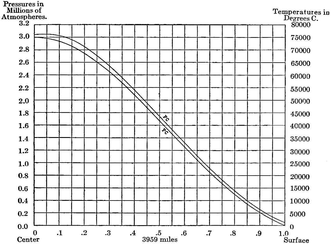
Fig.
451.—Diagram illustrating the internal temperatures of the earth when it first became solid, under the hypothesis that it solidified from the center outward, and assuming that the fusing-point rose directly as the pressure, in accordance with Barus’ experiments with diabase. The divisions of the base-line represent fractions of the earth’s radius. The divisions of the vertical lines represent pressures in atmospheres at the left, and temperatures in degrees
C.
at the right. The lower curve, PC, represents the interior pressures, ranging from one atmosphere at the surface to 3,000,000 atmospheres at the center, derived from Laplace’s law of density. The upper curve, FC, represents the fusion-points of diabase at the various depths and pressures, and hence the temperatures at which the interior would become solid at the various depths, or, in other words, the initial temperatures of the solid earth. The lower curve is derived from Slichter; the upper is formed by directly plotting the temperatures given by Barus (Am. Jour. Sci., 1893,
p.
7).
2. Thermal distribution on the hypothesis of central solidification.—When the previous conception was first formed, the effect of pressure on the melting-points of lavas was neglected, as little or nothing was known on the subject. Experiment, however, has shown that pressure, as a rule, raises the melting-points of lavas, and out of this has grown the doctrine that the earth solidified first at the center, where the pressure was greatest, and gradually congealed outwards. Barus has shown that the melting-point of diabase,[253] selected as a representative rock, rises directly with the pressure. If this rate holds good to the center of the earth, the melting temperature of diabase there would be 76,000° C. (136,800°F.). The range of the experiment is, however, very small compared with the range of the application, and little confidence can be felt in the special numerical result reached. The rate of rise of the fusion-point may be much changed as the extraordinary conditions of the deep interior are invaded. Still there is good ground for the hypothesis that solidification took place at some very high temperature at the center, because of the very great pressure there. The inference then is that when the temperature of the center of the supposed molten globe reached the appropriate point, solidification began there, and that it took place at lesser depths in succession as the appropriate temperatures were reached. This view excludes convection in the successive zones from the center outward after the time when their temperatures of solidification were reached, or after these were approached sufficiently near to develop prohibitive viscosity. Some loss of heat from these horizons would be suffered while the outer parts were solidifying, but on account of the exceedingly slow conductivity of rock, it is improbable that the amount of loss would be sufficient to change the general character of the internal distribution of heat previous to solidification at the surface, the time when the existing phase of the earth’s history by hypothesis began. Fig. 451 shows the theoretical distribution of heat under this view. The consequences of this assumption are very important to geological theory and, carried out to their logical consequences, lead to the conclusion that cooling and shrinkage affected the deep interior of the earth, for the high central heat must have been constantly passing out toward the surface. Instead, therefore, of the contraction being concentrated in and limited to the outer 200 miles or so, as under the preceding hypothesis, it was deeply distributed. The contraction within the outer zone would be less than under the preceding view, because the flow of heat from within would partially offset the flow outwards, and a corresponding part of the contraction would be distributed below.
COMPUTED PRESSURES, DENSITIES, AND TEMPERATURES WITHIN THE EARTH BASED ON LAPLACE’s LAW.
Distance from center in terms of radius. Pressure in megadynes per sq. cm.[254] Density. Temperature in degrees C.
1.00 0 2.80 0
.95 97,000 3.37 320
.90 215,000 3.95 1,110
.85 353,000 4.54 2,190
.80 510,000 5.13 3,470
.75 684,000 5.71 4,880
.70 874,000 6.28 6,350
.65 1,077,000 6.84 7,860
.60 1,289,000 7.38 9,360
.55 1,507,000 7.90 10,830
.50 1,727,000 8.39 12,250
.45 1,944,000 8.84 13,590
.40 2,154,000 9.26 14,840
.35 2,353,000 9.64 15,980
.30 2,535,000 9.98 17,000
.25 2,698,000 10.27 17,880
.20 2,836,000 10.51 18,610
.15 2,947,000 10.70 19,190
.10 3,029,000 10.84 19,610
.05 3,078,000 10.92 19,870
.00 3,095,000 10.95 19,950
3. Thermal distribution under the accretion hypothesis.—The accretion hypothesis assumes that the internal heat was gradually developed from the center outwards as the earth grew and the internal compression was progressively developed. The heat, therefore, continued to rise at the center as long as compression continued, or at least as long as the compression was sufficient to generate heat faster than it was conducted outwards. As the conduction of heat through rock is exceedingly slow, the central heat may be assumed to have continued to rise so long as the infall of matter caused appreciable compression. In the same way, heat was generated progressively in the less central parts, and these parts also received the heat that passed out from beneath. It is assumed under this hypothesis that the degree of interior compression stands in close relation to interior density, for while there would probably be some segregation of heavier matter toward the center and of lighter toward the surface by means of volcanic action and internal rearrangement under stress differences, the interior density is regarded as due mainly to compression. The distribution of internal pressure and density generally accepted is that of Laplace, who assumed that the increase of the density varies as the square root of the increase of the pressure. This law gives a distribution of density that accords fairly well with the phenomena of precession of the equinoxes, which require that the higher densities of the interior shall be distributed in certain proportions between the center and the equatorial protuberance whose attraction by the sun and moon causes precession. The increases in pressure, density, and temperature have been computed as follows by Mr. A. C. Lunn,[255] the average specific gravity of the earth being taken at 5.6, the surface specific gravity at 2.8, and the specific heat at .2.
The temperatures are shown graphically in Fig. 452, in which the curves of pressure and density are also given. The nature of the curve of temperature is such that, if the thermometric conductivity of the material is uniform at all depths, the temperature will fall in the deeper portions and rise in the outer ones, excluding the surface portions subject to outside cooling. The curve indicates that the rising temperature would affect somewhat more than 800 miles of the outer part of the spheroid, or about half its volume, i.e. the inner half during the initial period had a falling temperature and the outer half, except the immediate surface, a rising temperature. This introduces a very singular feature into the problem, for the outer zone must shrink to fit the inner portion that is losing heat, while its own material is expanding because of its increase of temperature. A double distortional effect must result.[256] If the conductivity of the dense interior is greater than that of the outer parts, the effect is intensified. The redistribution of heat resulting from this unequal flowage would in time change the curve so that more nearly equal flowage would result. It would probably take a very long period for this to be effected, on account of the very slow conductivity of rock.
The accretion hypothesis assumes that, during the growth of the earth, large amounts of heat were carried by volcanic action from deeper horizons to higher ones and to the surface, and that this still continues at a diminished rate. It assumes that whenever the interior heat raised any constituent of the interior matter above its fusing-point under the local pressure, it passed into the liquid state, and was forced outwards by the stress differences to which it was subjected, unless its specific gravity was sufficiently high to counterbalance them. It is conceived that the more fusible portions were liquefied first, and that in so doing they absorbed the necessary heat of liquefaction and began to work their way outward, carrying their heat into higher horizons and temporarily checking the development of more intense stresses in the lower horizons. They thus served to keep the temperature there below the fusion-point of the remaining more refractory substances. Meanwhile the extruded portions were raising the temperatures of the higher horizons into which they were intruded or through which they were forced to pass. There was thus, it is thought, an automatic action that tended to reduce the heat-curve to the fusion-curve. The actual curve of internal temperature may, therefore, be practically the fusion-curve. This is identical with the curve supposed to arise from solidification by pressure from the center outward under the molten hypothesis, except so far as the two would vary as the result of variations in the distribution of matter, which would not be quite the same under the two hypotheses. The curve of fusion deduced by an extension of the results of Barus’ experiment has been given. It is necessary to recognize that the rate of rise of the fusion-point may, and very likely does, change in the deep interior. The curve given represents much higher temperatures in the central parts than those given by Lunn’s computations from compression, which seem inherently more probable than the higher ones.
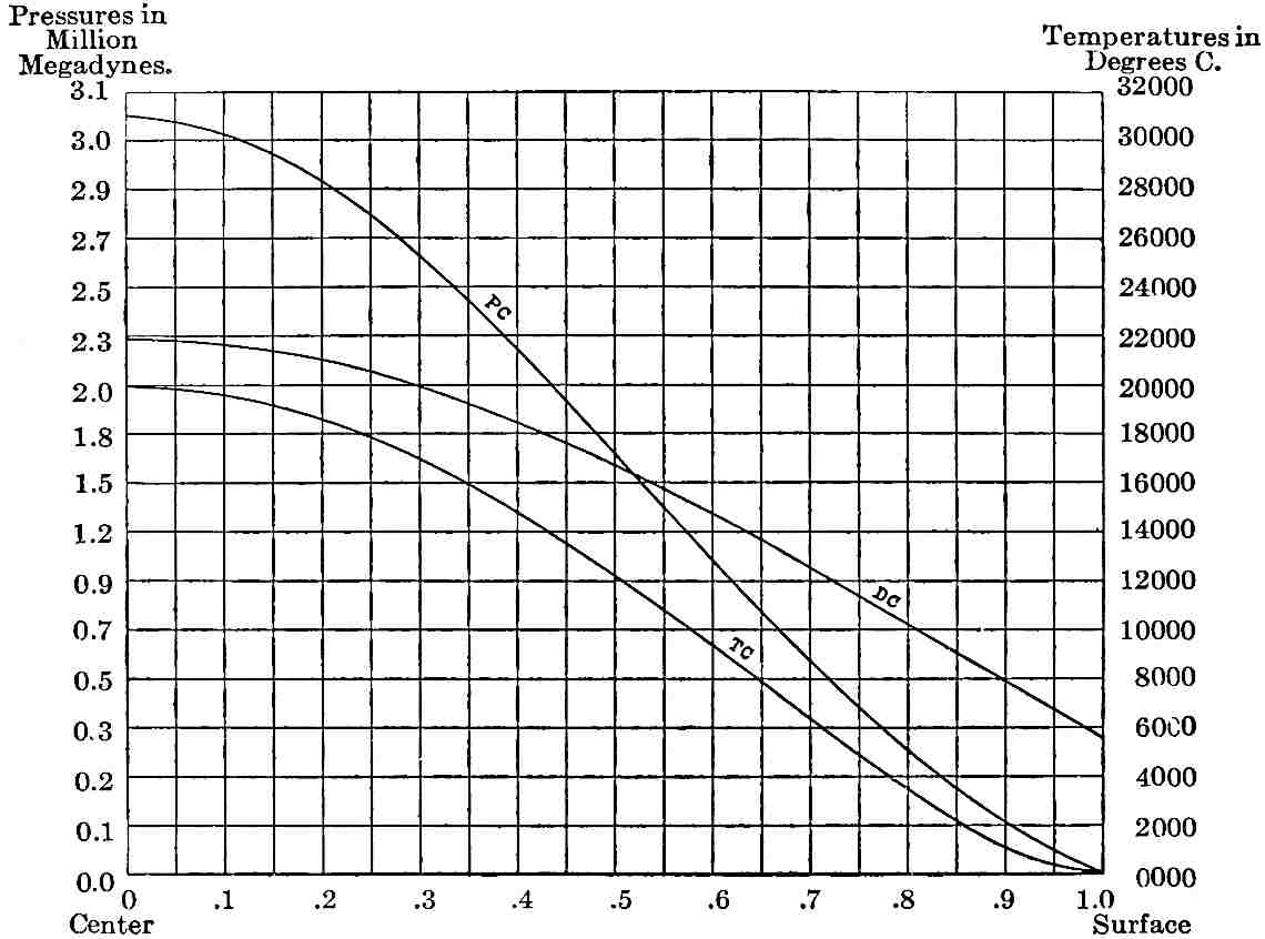
Fig.
452.—Diagram illustrating the distribution of temperature under the accretion hypothesis (neglecting the heat from infall and other external sources). The divisions of the base-line represent fractions of the earth’s radius. The vertical divisions represent both pressure in megadynes per sq. cm., nearly the same as atmospheres per sq. in., at the left, and temperatures in degrees
C.
at the right. It is to be noted that the temperature scale is 2000°
C.
per division, while that of
Fig.
451
is 5000°
C.
per division. The upper curve at the left, PC, is the pressure curve. The middle curve, DC, is the density curve, beginning at 2.8 at the surface and reaching nearly 11 at the center. The lower curve, TC, is the temperature curve, rising from the surface temperature, 0°
C.
, at the right, to 20,000°
C.
at the center. It is to be noted that the portion of this curve at the left representing the deeper part of the earth is convex upwards, while the portion at the right is concave. It will be seen that the gradient increases from the center to a point between .6 and .7 radius, and then decreases, and that between .8 radius and the surface, a distance of about 800 miles, the decrease is notable. This means that with an equal coefficient of conductivity the flow from the center outward to .6 or .7 radius will be faster than the flow from .8 radius to the surface, neglecting the immediate surface effects of external cooling. These curves were worked out by Mr. Lunn.
As astronomical and seismic evidences strongly favor the view that the earth is rigid throughout, they lend support to the view that the interior retains its rigidity by the extrusion of liquid matter practically as fast as it is formed, and that this progressive extrusion adjusts the temperature to that which is consistent with solidity.
The bearing of this conception becomes evident on consideration. The shrinkage of the earth from loss of heat by conduction and by the extrusion of molten rock, affects the deep interior as well as the more superficial zones. It is even possible that the shrinkage may originate chiefly in the deeper zones. The postulated transfer of fluid rock from the deeper parts to the more superficial ones lessens the heat in the former, and adds to that in the latter. The postulated greater flow of heat from the deeper half to the outer half, than from the latter outward, gives a concordant result. If the conductivity of the deeper and denser material is appreciably greater than that of the more superficial and less dense material, as seems probable, this effect is intensified. The distribution of compressibility at the existing state of condensation may possibly be such that more new heat is generated by shrinkage in the outer parts than in the inner. Neither of these conceptions can be affirmed as actually taking place. They merely lie within the range of reasonable hypothesis in the present state of experimental data. What the real truth is must be left to further research. Present effort may be regarded as temporarily successful if it forms consistent conceptions of the applicable hypotheses, and of their consequences.
Recombination of material.—One other peculiarity of the accretion hypothesis must be recalled here. The incoming bodies must probably be assumed to have fallen in promiscuous order, and hence to have been indiscriminately mingled in the growing earth. As they became buried deeper and deeper and their temperatures and pressures were raised, much recombination, chemical and physical, may be presumed to have followed. As already noted, these changes would probably give increased density in the main. The material being, however, in a solid state, the rearrangement would be slow and its persistence in time indeterminate, and it may yet be far from complete. It is not improbable, therefore, under this hypothesis, that some notable part of the recent shrinkage of the earth has been due to the continued rearrangement of its heterogeneous internal matter. This would not be equally so in an earth derived from a molten mass, for the required adjustments of the material should have taken place while in the fluid state before solidification.
Comparison of the hypotheses.—By comparing the three hypotheses of the early states of the earth’s temperature, it will be seen that there is a radical difference, thermally, between the first and the last two. The first assumes a nearly uniform distribution of internal temperature, and hence, owing to the exceedingly slow rate of conduction, limits the movements and deformations of the crust, so far as dependent on heat, to very superficial horizons. The second and third views agree in postulating changes of temperature in the deep portions, as well as in the superficial, and hence involve the central portion of the earth in the great movements and deformations. It is not to be supposed that this of itself necessarily increases the sum-total of the effects of contraction, for, given a certain loss of heat from the surface, it may be relatively immaterial whether this loss arose from a large reduction of temperature in a shallow zone, or a small reduction of temperature in a deep zone, for, except as the coefficient of expansion varies, the total shrinkage would be the same. But the difference in distribution makes a radical difference in the resulting movements, for, in the first case, the movements are in a weak superficial shell that cannot accumulate great stresses, and hence must yield practically as fast as the stresses arise, while, in the second case, the stress-accumulating power of the thick segments may be great, and the stresses may gather for long periods and give rise to great cumulative results at long intervals. In this respect the last two views have much in common, though they differ in other important particulars.
With this general background of hypothesis, we may now turn to the direct evidences of the distribution of internal temperature which observations near the surface afford. Unfortunately they are limited to a mere film, as it were, little more than ¹⁄₄₀₀₀ of the radius of the earth.
OBSERVED TEMPERATURES IN EXCAVATIONS.
As the earth is penetrated below the zone of seasonal changes by wells, mines, tunnels, and other excavations, the temperature is almost invariably found to rise. The rate of rise, however, is far from uniform. If we set aside as exceptional the unusually rapid rise near volcanoes and in other localities of obvious igneous influence, the highest rates are still six times the lowest. A large number of records have been collated by the Committee on Underground Temperatures, of the British Association for the Advancement of Science. These range from 1° F. in less than 20 feet to 1° F. in 130 feet, with an average of 1° F. in 50 to 60 feet, which has usually been taken as representative. The more recent deep borings that have been carefully measured with due regard to sources of error indicate a slower rate of rise. Some of the more notable records are as follows:[257]