Chapter III · (continued 3)
Reading edition
The history of the new cycle of erosion inaugurated by the uplift would differ from that of the preceding cycle in that the new one would begin with a drainage system already developed. Other things being equal, therefore, the reduction of the land would proceed more rapidly in a subsequent cycle than in the first.
The recognition of different cycles of erosion, separated by uplifts, is often easy. The principles involved are illustrated by Fig. 155 which represents an ideal profile of considerable length (say 50 miles). The points a, a′, and a″ reach a common level. Below them there are areas b, b′, and b″ which have a nearly common elevation, below which are the sharp valleys d, d′, and d″. The points a, a′, and a″ represent the cross-sections of ridges formed by the outcrops of layers of hard rock. If the crests of the ridges are level, the points a, a′, and a″ must represent remnants of an old base-level, since at no time after a ridge of hard rock becomes deeply notched does it acquire an even crest, until it is base-leveled.[60] At all earlier stages its crest is uneven. After the cycle represented by the remnants a, a′, and a″ was completed, the region suffered uplift. A new cycle represented by the plain b, b′, and b″ was well advanced, though not completed, when the region was again elevated, and the rejuvenated streams began to cut their valleys d, d′, and d″ in the plain of the previous incomplete cycle. The elevations, c and c′ (intermediate in elevation between a, a′, and a″, and b, b′, and b″) may represent either remnants of the first base-level plain which were lowered, but not obliterated, while the plane b, b′, b″ was developing; or they may represent a cycle intermediate between that during which a, a′, a″ and b, b′, b″ were developed. If the intermediate elevations (c, c′) have a common height and level crests, the presumption would be in favor of the latter interpretation. If they be numerous and of varying heights, as is possible, they may in the field obscure the planes (a, a′, a″ and b, b′, b″) developed in the different cycles, which, in the figure, are distinct.

Fig.
155.—Diagram to illustrate cycles of erosion where the beds are tilted.
If the strata involved be horizontal the determination of cycles is sometimes less easy. Thus in Fig. 156, it is not possible to say whether a and a′ represent remnants of an old base-level, or whether they represent the original surface from which degradation started. So, too, the various benches below a, such as b, b′, and b″ may readily be the result of the superior hardness of the beds at this level. For the determination of successive uplifts in the field it is necessary to consider areas of considerable size, and to eliminate the topographic effects of inequalities of hardness, and of certain other factors to be mentioned presently.

Fig.
156.—Diagram to illustrate cycles of erosion where the beds are horizontal.
The inequalities in the depths of the young valleys in Figs. 155 and 156 may be explained on the supposition that the deeper ones belong to main streams, and the shallower ones to tributaries. Such a valley as that shown at e, Fig. 155, suggests rejuvenation at this point; but farther up the stream which occupies this valley, rejuvenation might not be apparent. In this case, the main streams might be flowing in new valleys, d, d′, etc., while the heads of their tributaries are still flowing in the older valleys of the preceding cycle (compare Fig. 154 and Fig. 1, Pl. XIII).
It is by the application of the preceding principles that it is known that the Appalachian Mountains, after being folded, were reduced to a peneplain (p. 76), throughout their whole extent from the Hudson River to Alabama. The peneplain level is indicated by the level crests of the Appalachian ridges, shown in cross profile by the high points of Fig. 157. The system was then uplifted, and in the cycle of erosion which followed, broad plains were developed at a new and lower level, corresponding in a general way to the plains b, b′, and b″ of Fig. 155. The plains were located, for the most part, where the less resistant strata come to the surface. Above them rose even-crested ridges, the outcrops of the resistant layers, which had been isolated by the degradation of the softer beds between. They constitute the present mountain ridges (the high points of Fig. 157). The evenness of their crests, testifying to the completeness of the first peneplanation, is shown in Fig. 158, which represents, diagrammatically, a longitudinal profile of an Appalachian Mountain ridge. The evenness of the crest is interrupted by (1) notches (b, c, etc., Fig. 158) cut by the streams in later cycles, and (2) by occasional elevations above the common level (monadnocks, a, a′, Fig. 158). The monadnocks are generally rather inconspicuous, but there is a notable group of them in North Carolina and Tennessee. Mount Mitchell and Roane Mountain are examples. When long distances are considered, the ridge crests depart somewhat from horizontality. This is believed to be due, in part at least, to deformations of the old peneplain during the uplift which inaugurated the second cycle of erosion.

Fig.
157.—Cross-section of a portion of the Appalachian Mountains to illustrate the phenomena of erosion cycles. (After Rogers.)

Fig.
158.—A diagrammatic longitudinal profile of an Appalachian Mountain ridge.
The extent to which the second cycle of erosion recorded in the present topography had proceeded before its interruption by uplift, is indicated by the extent of the valley plains (Fig. 157) below the mountain ridges. While these plains were being developed on the weak rocks, narrow valleys only (Fig. 158) were cut in the resistant rocks which now stood out as ridges. In Fig. 158 some of these valleys are shallow (c, c′, c″, etc.), and but one of them deep. The former may be either (1) the valleys of streams which crossed the hard layer at the beginning of the cycle, and which were diverted before their valleys became deep; or (2) they may represent the heads of valleys now working back into the ridges. The deep valley (b) represents the work of a stream which has held its course across the hard layer while the latter was being isolated as a mountain ridge (compare Figs. 131 and 132). Deep narrows of this sort are often called water-gaps. Similar valleys, whether shallow or deep, from which drainage has been diverted, are sometimes called wind-gaps. The second cycle of erosion, while still far from complete, was interrupted by uplift (relative or absolute), and a new cycle inaugurated. This event was so recent that the new (third) cycle has not yet advanced far.
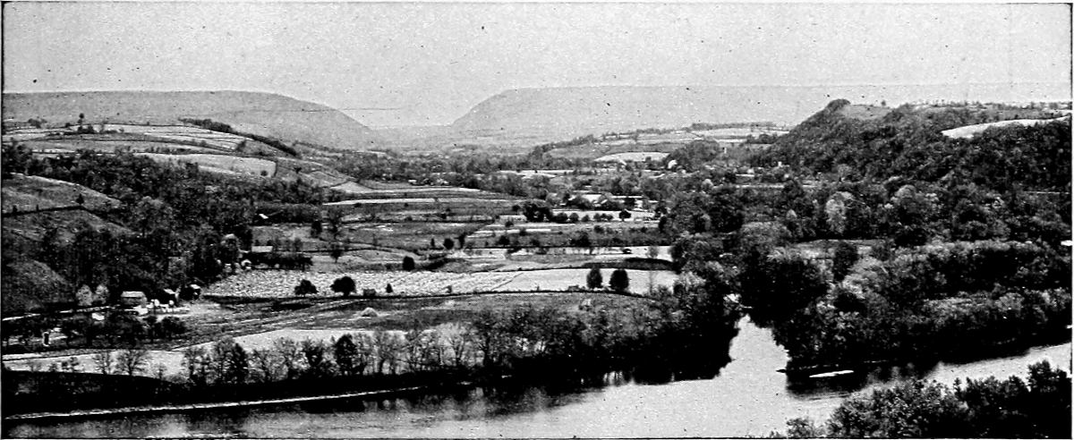
Fig.
159.—The Kittatinny Mountains and Delaware Water-Gap from Manunka Chunk. (
N. J.
Geol. Surv.
)
Recently it has been urged that another cycle, intermediate between the first and second, is to be recognized.[61]
Some of the features just described are illustrated by Fig. 159. The even mountain crest in the background is the Kittatinny Mountain of New Jersey and its continuation in Pennsylvania. In common with other corresponding crests it represents the oldest recorded base-level (or peneplain) of the region. The great gap in the mountain is the Delaware Water-Gap. Below the mountain crest there is another plain, developed in a subsequent cycle of erosion, while the valley plain in the foreground represents the work of a still later cycle.
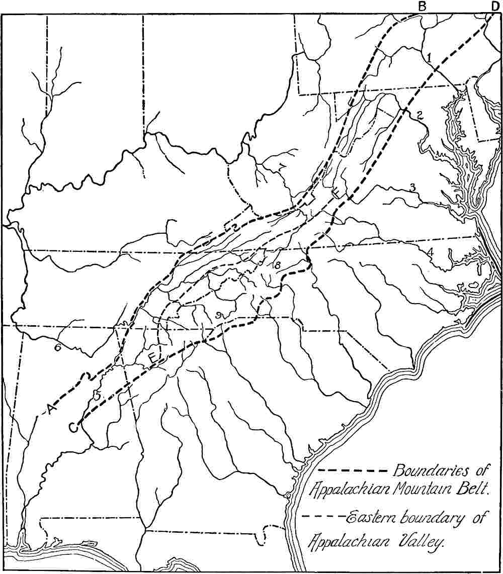
Fig.
160.—Showing certain peculiarities of Appalachian drainage. 1 = the Susquehanna; 2 = the Potomac; 3 = the James; 4 = the Roanoke; 5 = the Coosa; 6 = the Tennessee; 7 = the Kanawha; 8 = head of New River; 9 = head of the French Broad.
The oldest erosion plain of the Appalachian Mountains, the results of which are seen in the even-crested ridges so characteristic of the system, is sometimes called the Kittatinny base-level.[62] It was completed early in the Cretaceous period, and hence is sometimes known as the Cretaceous base-level. The next lower plain, imperfectly developed, has been called the Shenandoah Plain,[62a] from the Shenandoah Valley where it is well seen (Fig. 132 and Fig. 2, Pl. XII). It is to be noted that the terms base-level and peneplain have both been used in connection with these old plains. Graded plain is equally applicable. The truth is that the topographic types represented by these three terms grade into one another. It may be questioned whether definitions should be insisted on which differentiate these types more sharply than Nature has.
Many of the peculiarities of the drainage of the Appalachian Mountain system are intimately connected with the history just outlined. Thus three great rivers, the Delaware, the Susquehanna, and the Potomac, have their sources west of the Appalachians proper, cross the system in apparent disregard of the structure, and flow into the Atlantic. The James and Roanoke head far to the west, although not beyond the mountain system, and flow eastward, while the New River (leading to the Kanawha) farther south, heads east of the mountain-folds, and flows northwestward across the alternating hard and soft beds of the whole Appalachian system, to the Ohio (Fig. 160). The French Broad, a tributary to the Tennessee, has a similar course. Such streams are clearly not in structural adjustment, and afford good opportunities for piracy. Their courses were apparently assumed during the time of the Kittatinny base-level, when the streams had so low a gradient as not to be affected by the structure (p. 150). Elevation rejuvenated them, and they have held their courses in succeeding cycles across beds of unequal resistance, though smaller streams have become somewhat thoroughly adjusted. Crustal deformations have also helped them to hold their courses, for the Cretaceous peneplain seems to have been tilted to the southeast at its northern end, and to the southwest at its southern, when the succeeding cycle began.
Streams which hold their early courses in spite of changes which have taken place since their courses were assumed are said to be antecedent. They antedate the crustal movements which, but for pre-existent streams, would have given origin to a different arrangement of river courses. As a result of crustal movements, therefore, a consequent stream may become antecedent. Master streams are more likely to hold their courses, and therefore to become antecedent, than subordinate ones.
The uplift of base-leveled beds, especially if the beds are tilted so as to bring layers of unequal resistance to the surface at frequent intervals, affords conditions favorable for extensive adjustment. The numerous wind-gaps in the mountain ridges, representing the abandoned courses of minor streams, and the less numerous water-gaps, which indicate the resistance of large streams to structural adjustment, are instructive witnesses of the extent to which adjustment has gone. So extensive has been the adjustment among the streams of the Appalachian Mountains that there is probably no considerable stream in the whole system which has not gained or lost through its own or its neighbors’ piracy. The history of the rivers of the Appalachian Mountains has been further complicated by a considerable amount of warping during the periods of uplift.[63]
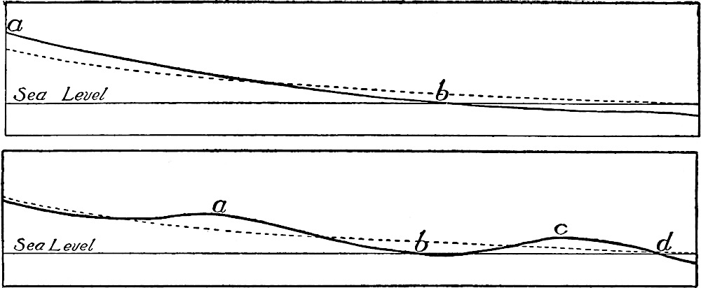
Fig.
161, 162.—Diagrams to illustrate the effect of crustal warping on stream erosion. The dotted lines represent the profiles of the streams before deformation; the full lines, after. Erosion will be stimulated between
a
and
b
in each case, and between
c
and
d
in
Fig.
162. Below
b
,
Fig.
161, the stream will be drowned, and erosion therefore stopped. Erosion will also be stopped or retarded above
a
, between
b
and
c
, and below
d
in
Fig.
162.
Sinking.—The land on which a river system is developed may be depressed relative to sea-level. In this case the sea would occupy the lower ends of valleys, converting them into bays and estuaries. A stream in this condition is said to be drowned. Of drowned rivers there are many examples along the Atlantic coast. Thus the St. Lawrence River is drowned up to Montreal, and the Hudson up to Albany. If the drowned portion of the latter valley were not so narrow, it would be a bay. Delaware and Chesapeake Bays, as well as many smaller ones, both north and south, are likewise the drowned ends of river valleys (see figures, Chapter VI). If all parts of a drainage basin sank equally, the velocities of the streams above the limit of drowning would not be changed, for the gradients would remain the same as before. The fact that a river’s channel is below sea-level is not to be taken as proof that the valley is drowned. Thus the bottom of the channel of the Mississippi is as much as 100 feet below the level of the Gulf, some 20 miles above New Orleans.[64]
Differential movement. Warping.—Where a land surface on which a river system is established suffers warping, some parts going up and others down, the opposite movements being either absolute or relative, various phenomena would result. This may be illustrated by the accompanying diagrams (Figs. 161 and 162), where the profiles of the streams are represented as warped from the positions represented by the dotted lines, to the positions shown by the full lines. The velocity will be accelerated below the points of differential elevation (between a and b, Fig. 161, and between a and b, and c and d, Fig. 162), but checked above (above a, and between b and c, Fig. 162). Above an elevation which notably checks its flow, a stream is ponded. If the ponding is slight, a marsh may develop above the obstruction; if more considerable, a lake is formed. Lakes of this class are likely to be short-lived, since the ponded waters are likely to soon overflow and lower their outlet so as to drain the lake. The elevation which ponds the stream may be great enough and rapid enough so that the resulting lake finds an outlet by some course other than that originally followed by the stream. Where a stream holds its course across an uplift athwart its valley, either with or without ponding, it becomes an antecedent stream (see p. 169), since it has a course assumed before the latest deformation of the crust and in apparent disregard of present surface configuration. Thus the Columbia River holds its antecedent course across areas which have been uplifted (differentially) hundreds and even thousands of feet.[65] Some of the striking scenic features of this noble valley are the result of these changes in the country through which it flows. A lesser stream would have been diverted, as many of its tributaries have been. Even its course across the Cascade ranges is believed to be antecedent.[66]
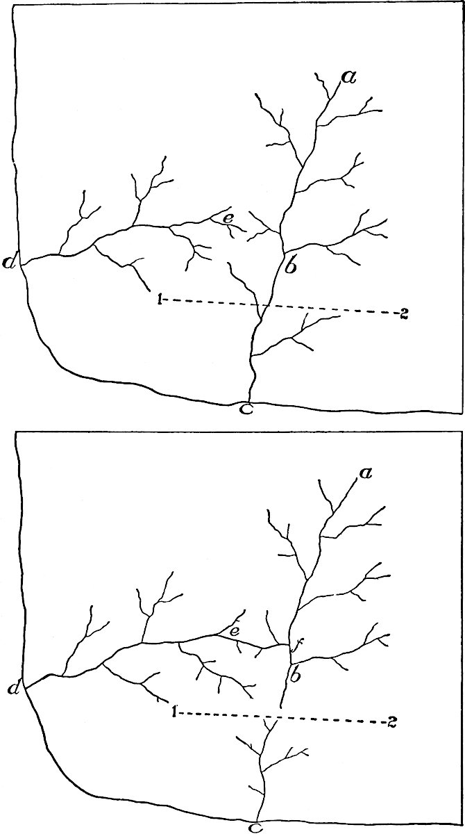
Fig.
163, 164.—Piracy stimulated by warping. Uplift along axis 1–2.
Another peculiarity of valleys and streams resulting from changes of level is illustrated in Fig. 2, Pl. XIV (southern California). The main valleys of this part of the coast were developed when the land stood considerably higher than now. Later the subsidence of the coast converted the lower ends of the valleys into bays or fiords. The bays were then transformed into lagoons by deposition. Subsequent rise of the land or depression of the sea allowed the drainage from the old lagoons to cut across the deposits which had converted the bays into lagoons. The result is an old, wide valley above, suggested by a young one below.
If the warpings were considerable, much more decisive changes in drainage would result. Suppose the drainage of a given region to be represented by the streams in Fig. 163. If there is uplift along the axis 1–2, that part of ac above the axis of uplift would be ponded, or at least have its velocity checked, while the flow of some of the tributaries of d would be accelerated, and might work back and capture the other stream (Fig. 164).
Crustal warping was one of the conditions under which the Tennessee achieved its present anomalous course, and its history[67] is illustrative of the complex changes which drainage suffers when warping affects the area where the rock structures are of unequal resistance. At the close of the Cretaceous cycle of erosion, when the Appalachian Mountains had been reduced to a peneplain, the waters falling in the area now drained by the upper course of the Tennessee flowed south-south-west to the Gulf in a stream (the Appalachian River, a, Fig. 165) the lower part of which had the general position of the Coosa and the Alabama.
To the west of the Appalachian River, shorter streams flowed west and southwest into the Mississippi embayment (Fig. 165) by courses which are not now definitely known. The succeeding cycle of erosion was inaugurated by uplift and deformation of the peneplain. The axis of greatest elevation (AB, Fig. 166) was nearly parallel to the Appalachian River, and the effect of the differential uplift was to impose a greater task on this river (a, Fig. 166), which flowed along the axis of uplift, than upon the rivers which flowed westward and southwestward to the Mississippi embayment. The result was that the strongest of the southwesterly flowing streams worked its head back into the drainage basin of the Appalachian River, and captured, one by one, the head-waters of its westerly tributaries, establishing some such drainage relations as are shown in Fig. 166. Still later, after the land area of the region had been considerably extended by the withdrawal of the sea, the Appalachian River itself was reached by the invading stream, and its waters carried away to the Mississippi Bay by a course the lower part of which is thought to have corresponded approximately with the course of the present Black River (b, Fig. 167).
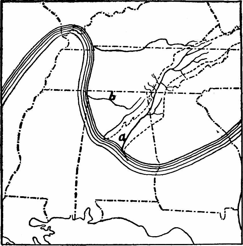
Fig.
165.—Shows the general position of the main drainage lines in the southern Appalachians at the close of the Cretaceous cycle of erosion. The lower part of stream
b
is made to follow the course of a portion of the present Tennessee.
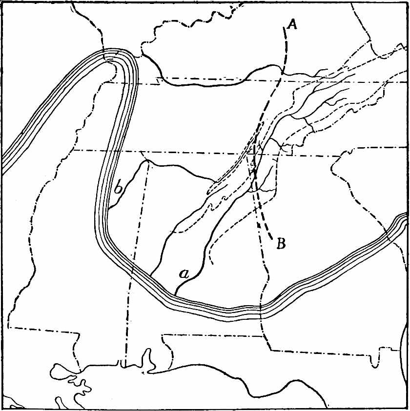
Fig.
166.—Shows the general position of the main drainage lines in the southern Appalachians, after the capture of the westerly tributaries of the Appalachian River by stream
b
. Compare
Fig.
165
.
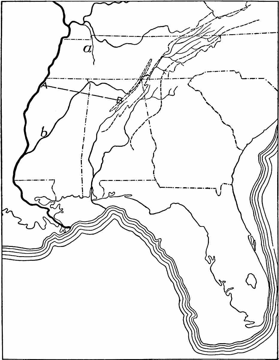
Fig.
167.—A stage later than that shown in
Fig.
166
. The sea is represented as having withdrawn from a considerable area which was submerged at earlier stages (
Figs.
165
,
166
).
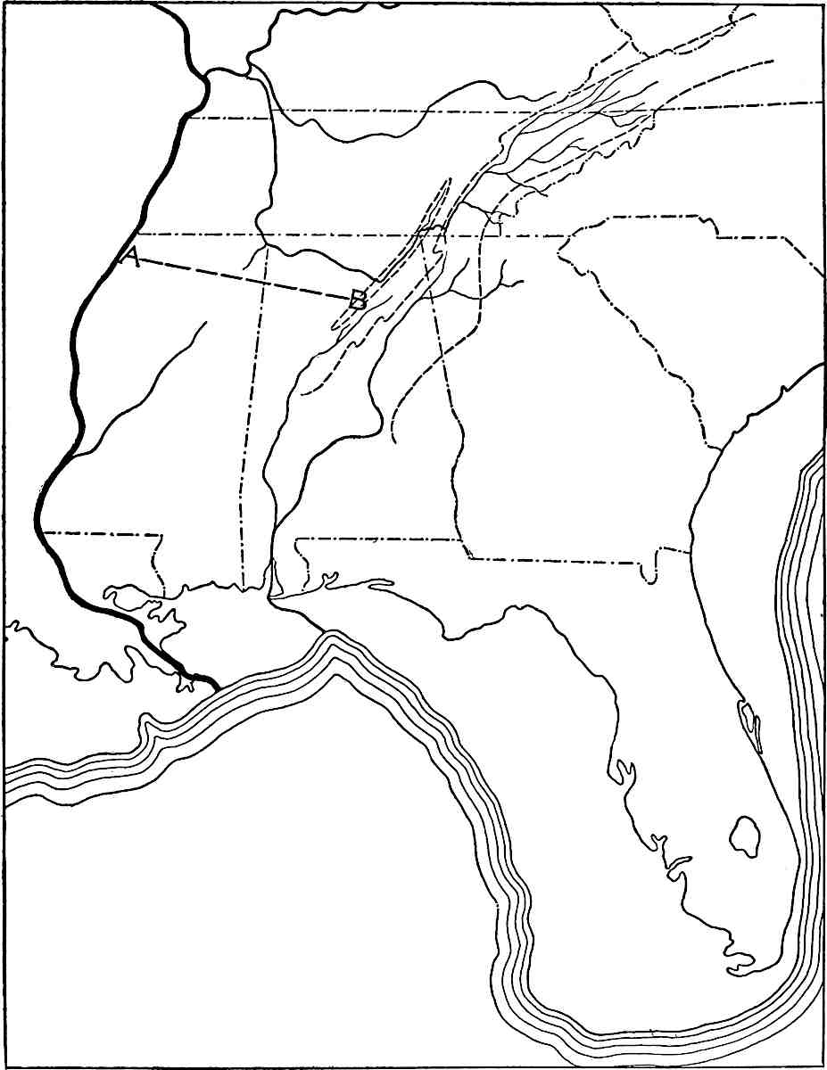
Fig.
168.—Shows the final change which resulted in the present course of the Tennessee. The land is represented as somewhat higher than now.
Still later there was further deformation which caused additional changes in the drainage. The whole region was uplifted, relatively if not absolutely, but the uplift was differential, being greatest along the axis represented by AB, Fig. 167. The effect of the deformation was to stimulate the tributaries of the Ohio flowing north from this axis. Their growth was further accelerated by the weakness of the strata over which they ran. At the same time, the uplift to the south led the southwesterly flowing stream (b, Fig. 167) to discover relatively hard beds of rock in its lower course, and these beds retarded its down-cutting. The result was that a tributary of the Ohio (a, Fig. 167) finally tapped the main stream flowing to the southwest (b, Fig. 167) and carried its upper part over to the Ohio (Fig. 168). This was the beginning of the present Tennessee.
THE AGGRADATIONAL WORK OF RUNNING WATER.
Principles involved.—Since deposition results from the failure of transportation, the factors which control transportation also influence deposition. Transportation by streams is determined largely by velocity, and the most important factors influencing velocity are slope, volume, and load (p. 115). Of these the first two are usually of greater importance than the third.
A stream is said to be loaded when it has all the sediment it can carry; it is loaded with fine material when it has all the fine material it can carry, and with coarse material when it has all the coarse it can transport. A stream loaded with coarse material flows more swiftly than one loaded with fine, for a larger percentage of a stream’s energy can be utilized in carrying fine material than coarse, and hence a larger percentage of the energy of a stream which carries a load of the latter will express itself in velocity.
Deposition takes place whenever a stream finds itself with more load than it can carry, and is an expression of the stream’s refusal to remain overloaded. A stream may become overloaded in various ways. It might at first seem unnecessary to inquire whether a stream may be overloaded at its source, but the question is not necessarily to be answered in the negative. The source of a stream is not always a definite point. In a general way it may be said that the source of the normal stream is at that point in its valley where the bottom is as low as the ground-water level of the region. But since the ground-water level is not constant (p. 71) the source of a stream is likely to be farther up its valley in a wet season than in a dry one (p. 72). After a heavy shower, the run-off descends to the axis of the valley from the slopes on all sides, and temporarily the stream begins above the point which marks even its wet-season source. If under such circumstances the slopes about the head of the valley are notably steeper than the slope of the valley itself, as they frequently are, the water flowing down them may gather an amount of material which it cannot carry after it reaches the bottom of the valley. This may be the case at, or even above, the point which marks the source of the permanent stream. It is, therefore, possible for a stream to be overloaded at its source, if we take the source to be the point whence the water permanently flows. Deposition may, therefore, be taking place in a valley at the head of its permanent stream, or temporarily even in the valley above it.
Streams issuing from glaciers sometimes have more load than they can carry after they escape from the ice. If the stream be regarded as beginning at the point where it issues from beneath the ice it may be overloaded at its source.[69]
Under certain circumstances, a stream may overload itself. Thus if a stream loaded with coarse detritus reaches a portion of its valley where fine material is accessible in abundance, some of the velocity which is helping to carry the coarse may be used in picking up and carrying the fine. This reduces the velocity, and since the stream already had all the coarse material it could carry, reduction of velocity must result in deposition. It follows that when a stream fully loaded with coarse material picks up fine, it becomes overloaded, so far as the coarse material is concerned.
Again, tributaries may overload their mains. While tributaries are usually smaller than their mains, they frequently have higher gradients, and the smaller stream of higher gradient may bring to the larger stream of lower gradient more material than the latter can carry away. Thus deposition may take place at the point of junction of tributaries with their mains. This may go so far as to pond the latter enough to cause its expansion into a river-lake. Lake Pepin, in the Mississippi River at the mouth of the Chippewa (in Wis.), is an example.
Streams may become overloaded by losing velocity or volume, or both. Decrease in velocity is brought about either by decrease in declivity or in volume. In general, streams have lower gradients and greater volumes in their lower courses than in their upper, and these two elements affect velocity in different ways. If the increase in volume be not enough to counterbalance the decrease in declivity, as is often the case, a stream which is loaded in its upper course will deposit in its lower. The decrease of velocity at the debouchure of a stream almost always leads to deposition.
Decrease in velocity as the result of decrease in volume is less common. When decrease in volume occurs, it may be the result of (1) evaporation, (2) the absorption of water into the bed of the stream, or (3) branching—the giving off of distributaries. While evaporation is going on everywhere, the diminution of a stream by this means is usually more than balanced by the increase from tributaries, rainfall, and springs; but in arid regions a very different condition of things sometimes exists. If mountains in an arid region be capped with snow, its melting supplies the streams during the melting season. As the streams flow out from the mountains through dry regions, they receive little or no increment from rainfall, tributaries, or springs, and evaporation reduces the volume of water, or even dissipates it altogether. Absorption of water into the bed of the stream often accompanies evaporation. Reduction of volume by evaporation and by absorption is especially common in arid regions. Wherever loaded streams are reduced in volume, whether by evaporation or absorption, deposition takes place.
The third way by which velocity is decreased as the result of decreasing volume is illustrated at the debouchures of many streams. Near the Gulf, for example, the Mississippi branches repeatedly (see Fig. 190). The same phenomena are often seen where one stream joins another (Fig. 169). Individually the distributaries are much smaller than the main stream before they separated from it, and because they are smaller their combined surfaces are greater, and the amount of energy consumed in the friction of flow is increased. The velocity of the water and its carrying power are, therefore, reduced. Thus the branching of streams gives rise to deposition, and where deposition takes place the gradient of the stream is reduced, and this occasions still further deposition. The sediment which fills up the channel and checks the flow finally compels the stream, or some part of it, to transgress its banks. Deposition, therefore, favors the development of distributaries, and the development of distributaries in turn favors deposition.
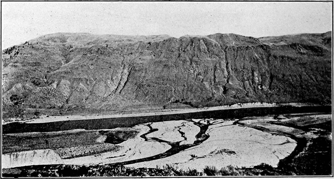
Fig.
169.—Delta of the Chelan River at its junction with the Columbia. Shows the tendency of streams to distribute where active deposition is in progress. (Willis,
U. S. Geol. Surv.
The foregoing statements make it clear that a stream may be eroding in one part of its valley while it is depositing in another, and that erosion may alternate with deposition in the same place, on account of fluctuations in volume, and, therefore, in velocity of the stream. It will be seen in the sequel that erosion and deposition may be taking place at the same time in the same part of the valley. The activities of a river are so nicely balanced that slight disturbance at one point causes disturbance at all points below.
The deposits.
Types.—Turning from the principles which underlie river deposition to the deposits themselves, they are found to occur in various situations. Running water usually descends from steeper slopes above to gentler slopes below, and ends at the sea, or in a lake or inland basin. Wherever there is a sudden decrease in its gradient, as at the base of a hill, ridge, or mountain, running water is likely to leave a large part of its load, building an alluvial fan or cone (Figs. 67, 68, and Pl. VI). Even where there is no sudden decrease in the gradient of a stream, there is likely to be a gradual one, and in spite of the fact that the increased volume of a stream in its lower course tends to overcome the effect of diminished gradient on velocity, deposition is likely to take place as the gradient is reduced. Deposits occasioned by the gradual reduction of a stream’s velocity often have great extent in the direction of a stream’s flow. They cover the flood plains of streams, making them alluvial plains (Fig. 73). When a stream reaches the sea or a lake its current is destroyed and its load dropped, unless taken in charge by the waves and currents of the standing water. Sediment accumulated in quantity at the debouchures of streams gives rise to deltas (Figs. 169, 187). Alluvial cones and fans, alluvial plains, and deltas, are the principal types of river deposits. Apart from these well-defined types there are bars in the channels of depositing streams, and much ill-defined alluvium which does not allow of ready classification.
Alluvial fans and cones.—The only distinction between the alluvial fan and the alluvial cone is one of slope, the cones (they are but half-cones at best) being steeper than the fans. Alluvial fans and cones have their most striking development where temporary torrents, occasioned by showers or the rapid melting of snow, issue from mountain ravines. Such streams usually carry heavy loads of detritus, the coarser part of which is likely to be deposited at the base of the mountain slope. Cones and fans built by such streams have a periodic rather than a steady growth.
At the beginning of its development the material of the alluvial cone is deposited much as in a talus cone (compare Fig. 170 with Figs. 67 and 68). Its deposition chokes the channel of the stream, and some of the water then seeks new courses to right and left of the apex of the deposit. This expands the area of deposition to right and left, while the water which flows over it lengthens it in the direction of flow.
The course and behavior of the water after reaching an alluvial cone is instructive. As its velocity is checked, deposition often takes place in the channel, diminishing its capacity. As the channel is filled up, the water tends to overflow on either side. The overflowing water, being shallow, has so little velocity that much of its load is dropped on either margin of the channel, building up levees. The water ever and anon breaks through the levees, giving rise to distributary streams, each of which aggrades its channel and builds its own miniature levees (Fig. 171). Not rarely this process of channel-filling and levee-building goes on until the channels of the little rivulets are above the general level of the cone on which they rest. The rivulet then runs in a groove on the crest of a little ridge. The channels on the surfaces of fans and cones are fewest and deepest at their heads, and more numerous and shallower below. In some cases the surface-water disappears altogether before the outer border of the fan is reached, by sinking into the débris.
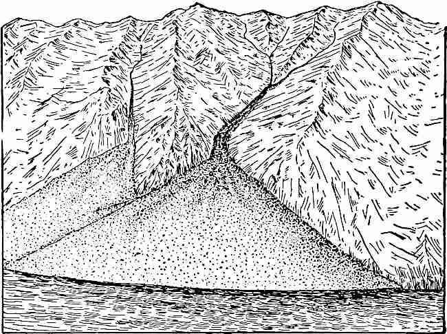
Fig.
170.—A talus cone. North Greenland Coast. The talus cone reaches the sea-level. Drawn from photograph.
Alluvial fans and cones have various forms, and often attain considerable dimensions. Their angles of slope depend on the amount of reduction of velocity which the depositing water suffers, and the amount and kind of load which it carries. The maximum slope of the cone is the angle at which the loose material involved will lie. The minimum slope of the fan, on the other hand, approaches horizontality. If many alluvial fans develop in proximity to one another, as at the base of a mountain range, they may expand laterally until they merge. A long succession of them may thus give rise to an extensive alluvial piedmont plain, or a compound alluvial fan. The lower edge of such a fan is often somewhat lobate. Such plains exist along the bases of many mountain ranges (Pl. VI), and may be seen in miniature even along low ridges.
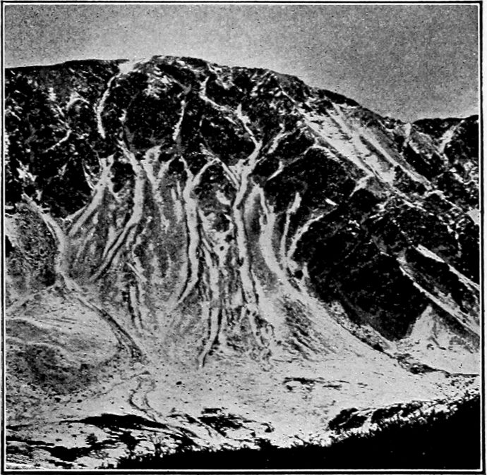
Fig.
171.—Miniature levees on an alluvial cone. Slope of Gray Peak,
Colo.
(R. T. Chamberlin.)
A permanent stream, as well as a temporary one, may develop an alluvial fan at the base of a mountain slope; but since the mountain course of the former is likely to be less steep than that of the latter, its waters suffer a correspondingly less reduction of velocity at any one point. The fan of the permanent stream is therefore likely to be relatively flat, and to stretch far down the valley. Such fans grade into valley plains. From the general principles already discussed, it is clear that well-developed fans go with relatively youthful stages of erosion, and belong normally to the upper parts of drainage lines.
Ill-defined alluvium.—There is a widespread mantle of alluvial material deposited by running water which was not organized into distinct streams. The water which runs down smooth slopes in sheets during showers carries fine earthy matter, as well as some that is coarser. These materials are largely deposited at the bases of the slopes, forming basal accumulations of greater or less extent, comparable in origin to alluvial fans. A relatively small amount of the slope wash is carried far out from the base of the declivities. It is not easy to realize the extent to which this process is taking place. There is hardly a slope without loose material, and there is hardly an acre of low land below a slope on which running water has not deposited sediment washed down from above. When it is remembered that this is as true of gentle slopes and their surroundings as of steep slopes, though perhaps not to the same extent, and that a very large part of the earth’s surface is made up of sensible slopes, or of flats at their bases, some idea of the aggregate effect may be gained.
There is another way of looking at the same question. Earthy matter is being continually transferred from land to sea, and chiefly from high land. Rarely does it start from any point distant from the shore and move uninterruptedly to it. It is transported a short distance and lodged, to be again picked up, carried forward another step in its journey, and lodged again. For a very large part of the earth’s surface it would be true to say that its mantle rock is material in transit from higher land to the sea.
Alluvial plains.—Most streams, whether heading in mountains or not, have gentler gradients in their lower courses than in their upper, and in spite of increasing volume are usually unable to carry to their debouchures all the material gathered above. The excess of load is dropped chiefly on the flood-plains of the streams and constitutes them alluvial plains.
The making of an alluvial plain usually involves both erosion and deposition. When a stream has cut its channel to grade, downward erosion ceases, or more exactly, downward cutting is, on the average, counterbalanced by deposition. So long as a stream is cutting downward rapidly, it carries away whatever débris descends the side slopes. When it approaches grade, the débris which descends the side slopes tends to accumulate at their bases, and the V-shaped cross-section of the valley becomes U-shaped (see Fig. 172). At about the same time the stream begins to meander, for, having lost something of its former velocity, it is more easily turned from side to side. As it begins to meander, it widens the bottom of its valley. This is the initial stage in the development of the valley flat (2 and 3, Fig. 172). In its meandering the stream encroaches on the talus accumulations at the bases of its valley’s slopes. The side-cutting may remove all the loose débris and even undercut the bluff as at a, Fig. 173. The stream’s meanders shift their positions from time to time so that the valley flat is successively widened at different points. By lateral planation, therefore, a stream tends to develop a flat as soon as it reaches grade. This is the initial part of erosion in the making of a river flat, but a flat developed by erosion alone is not an alluvial plain.
So soon as the flat developed by a stream exceeds the width of its channel, the water (except in times of flood) does not cover it all at the same time. On any part which it temporarily abandons, some débris (alluvium) is likely to be left. This deposit of alluvium constitutes the valley flat an alluvial plain (Fig. 174). It will be seen that the valley flat is commonly an alluvial plain from the beginning.

Fig.
172.—Diagram illustrating the transformation of a V-shaped valley into a U-shaped valley.

Fig.
173.—Diagram to illustrate the widening of a valley flat by erosion. Compare 3,
Fig.
172
.
Once the valley flat and alluvial plain are begun, their further development is easily followed. The stream in flood overflows the banks of its channel. The velocity of the overflowing water is reduced, and if it has much load a part of it will be dropped and the plain aggraded. Meantime meandering and lateral planation continue. Thus the flood-plain is widened by erosion, and aggraded by alluviation, the two processes going on simultaneously.

Fig.
174.—An alluvial plain. The diagram suggests the relative importance of lateral planation and alluviation in the development of the flat.
Flood-plains, chiefly the result of planation, but partly of aggradation, are a normal feature of river valleys, after a certain stage of development has been reached. This stage is that at which downward erosion becomes slight in comparison with lateral erosion. It follows that an alluvial plain normally begins its development where the valley is first brought to grade, that is, in its lower course. As the development of the valley goes on, the head of the flood-plain advances up-stream, and at the same time its older parts become wider.
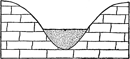
Fig.
175.—Diagrammatic representation of a flood plain developed by alluviation only.
Flood-plains due to alluviation only.—Exceptionally, an alluvial plain is developed by deposition only. Thus if a stream becomes overloaded while its valley is still narrow, as sometimes happens, deposition follows, and, as aggradation proceeds, the narrow valley acquires a progressively wider bottom (Fig. 175). Wide valley plains are sometimes developed in this way. Flood plains developed wholly by alluviation are sometimes formed under conditions which are independent of the stage of a valley’s development. Thus if a stream suddenly acquires an exceptional supply of detritus in its upper course, the development of an alluvial plain begins immediately below the point of overloading.
The overload might be acquired in various ways. (1) If a stream taps another (piracy) which carries a large quantity of sediment, carrying off both water and sediment to a channel with a lower gradient, deposition may take place where, under the earlier conditions, there was none. (2) Again, when a stream cuts through a barrier near its head waters, its velocity, and, therefore, its eroding power, may be so increased in its upper course that sediment enough is acquired to occasion deposition below, where none took place before. (3) In working back through formations of varying degrees of resistance, a stream’s head may presently reach a formation or a region which yields abundant sediment, even though there was no especial barrier below. (4) If an advancing glacier should reach the head waters of a stream, its discharge to the stream would greatly increase the load of the latter, and, although its volume would be augmented at the same time, deposition might result. As a matter of fact, streams carrying glacial drainage are usually aggrading streams. In general, anything which greatly increases the load of a stream near its head is likely to cause deposition, and so the development of a flood plain, at some point farther down the valley.
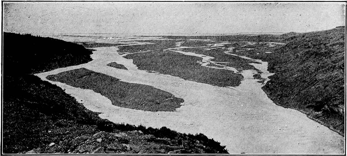
Fig.
176.—Anastomosing of a depositing stream. Yahtse River, Alaska. (Russell,
U. S. Geol. Surv.
)
Streams which are actively aggrading their valleys are likely to anastomose (Figs. 176, 177). This results from the filling of the channels until they are too small to accommodate all the water. The latter then breaks out of the channel at few or many points. The new channels thus established suffer the same fate.
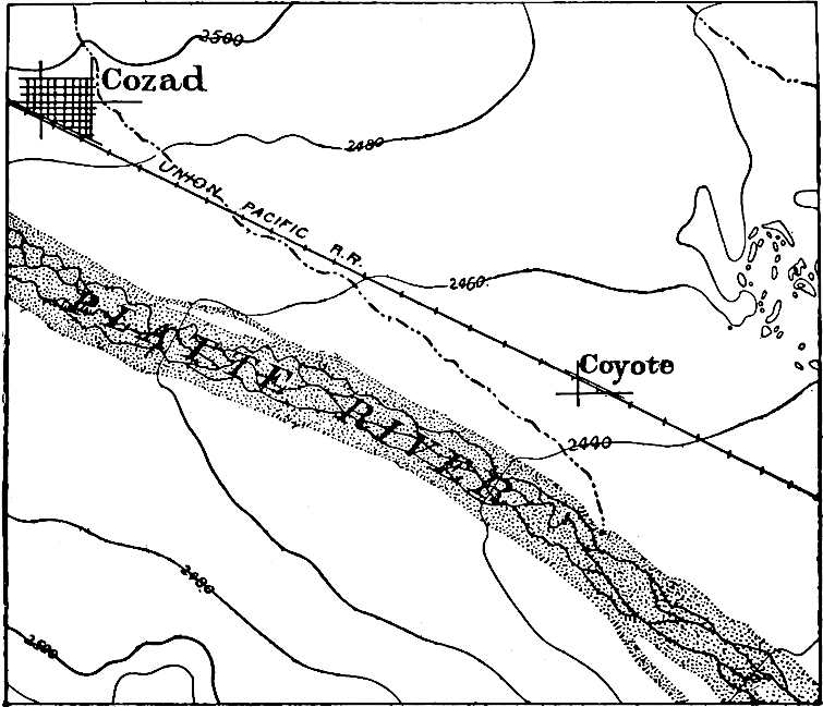
Fig.
177.—Anastomosing of the Platte River, Dawson
Co.
, Neb. (
U. S. Geol. Surv.
)
Flood-plains due to obstructions.—Again, any obstacle in a stream’s course is likely to cause deposition above. Thus dams built across rivers entail the deposition of sediment above. Where a stream flows over the outcropping edges of strata of different strength, the more resistant serve, in some sense, as dams. Above them the stream cuts its bed to a low gradient, and, becoming sluggish, drops more or less of the detritus brought down from above. Obstacles of any sort across a stream’s channel, therefore, favor the development of alluvial plains.

Fig.
178.—The levees of the Mississippi in cross-section, 4 miles north of Donaldsonville, La. Vertical scale ⨉50. The horizontal line in the diagram represents sea-level. The bottom of the channel at this point is far below sea-level.
Levees.—As the stream in flood escapes its channel and overspreads its plain, its immediate banks are the site of active deposition, for it is here that the velocity of the overflowing water is first notably checked. On the banks of the channel, therefore, low alluvial ridges, called natural levees, are built up (Fig. 178, and Pl. XV). They may be narrow, or hundreds of feet in width, and are often several feet above the plains behind them, giving the latter a slope away from the channel of the stream. They are sometimes high enough to control the courses of tributary streams, as shown by numerous tributaries to the Mississippi below the Ohio. The Yazoo, for example, flows some 200 miles on the flood-plain of the Mississippi before it joins that river near Vicksburg. The levees even become divides, directing drainage away from the streams they guard (Pl. XV). Streams sometimes build levees faster than their tributaries aggrade their channels. The latter are then ponded, giving rise to lakes. The lakes on the lower courses of the tributaries to the Red River of Louisiana are examples.[70] They are sometimes built up above their natural level and kept in repair by human agency so as to confine the streams in time of flood. This is a source of danger unless they be steadily maintained, for the breaking of such levees often occasions great destruction. A case in point is the breaking of the levees of the Mississippi near New Orleans in 1890. The water broke through the levees at the Nita and Martinez crevasses (Fig. 187) and flowed eastward (from the former) with a current of 15 miles per hour, spreading destruction in its path. The water flowed eastward through Lakes Pontchartrain and Borgne, and entered Mobile Bay with such volume, velocity, and load of mud, as to destroy for a time the oyster and fish industries of that locality.[71]
PLATE XV.
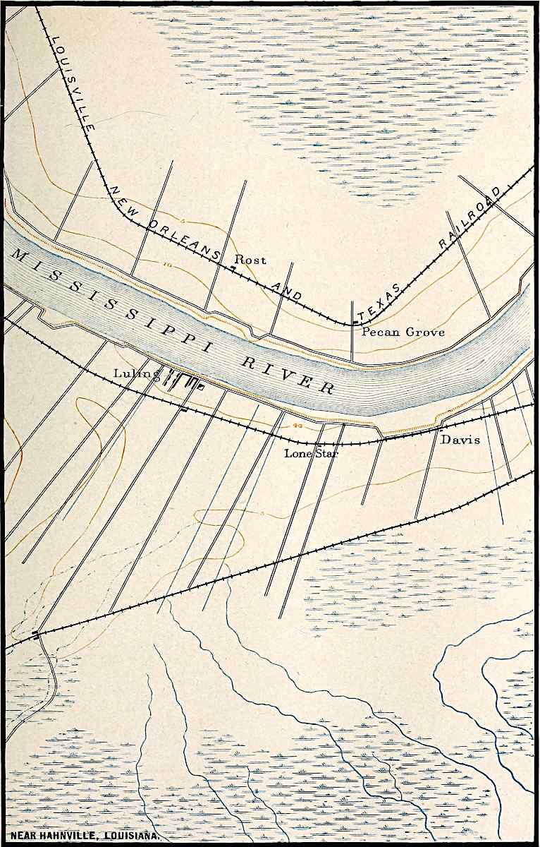
U. S. Geol. Surv.
Scale, 1+ mile per inch.
NEAR HAHNVILLE, LOUISIANA.
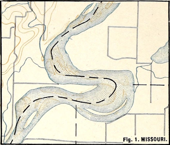
U. S. Geol. Surv.
Scale, 2+ miles per inch.
Fig.
1. MISSOURI.
PLATE XVI.
U. S. Geol. Surv.
Scale, 2 miles per inch.
Fig.
2. MISSOURI.
U. S. Geol. Surv.
Scale, 2+ miles per inch.
Fig.
3. MISSOURI.
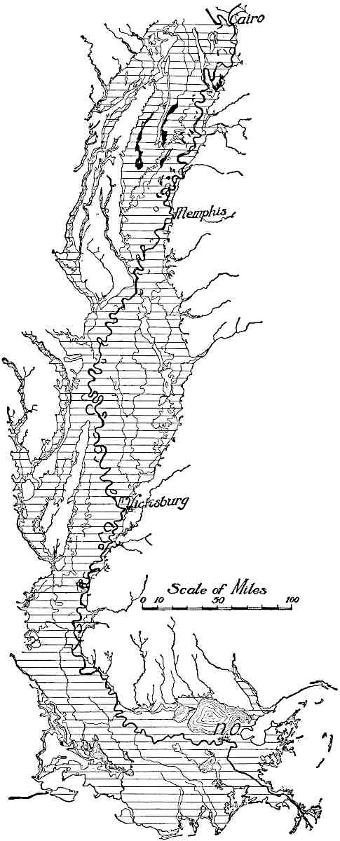
Fig.
179.—Flood-plain of the Mississippi River south of the mouth of the Ohio. (From charts of the
Miss.
Riv. Commission.)
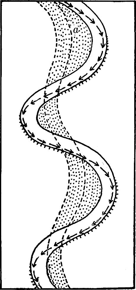
Fig.
180.—Diagram illustrating an early stage in the development of meanders. The shaded part represents the area over which the stream has worked.
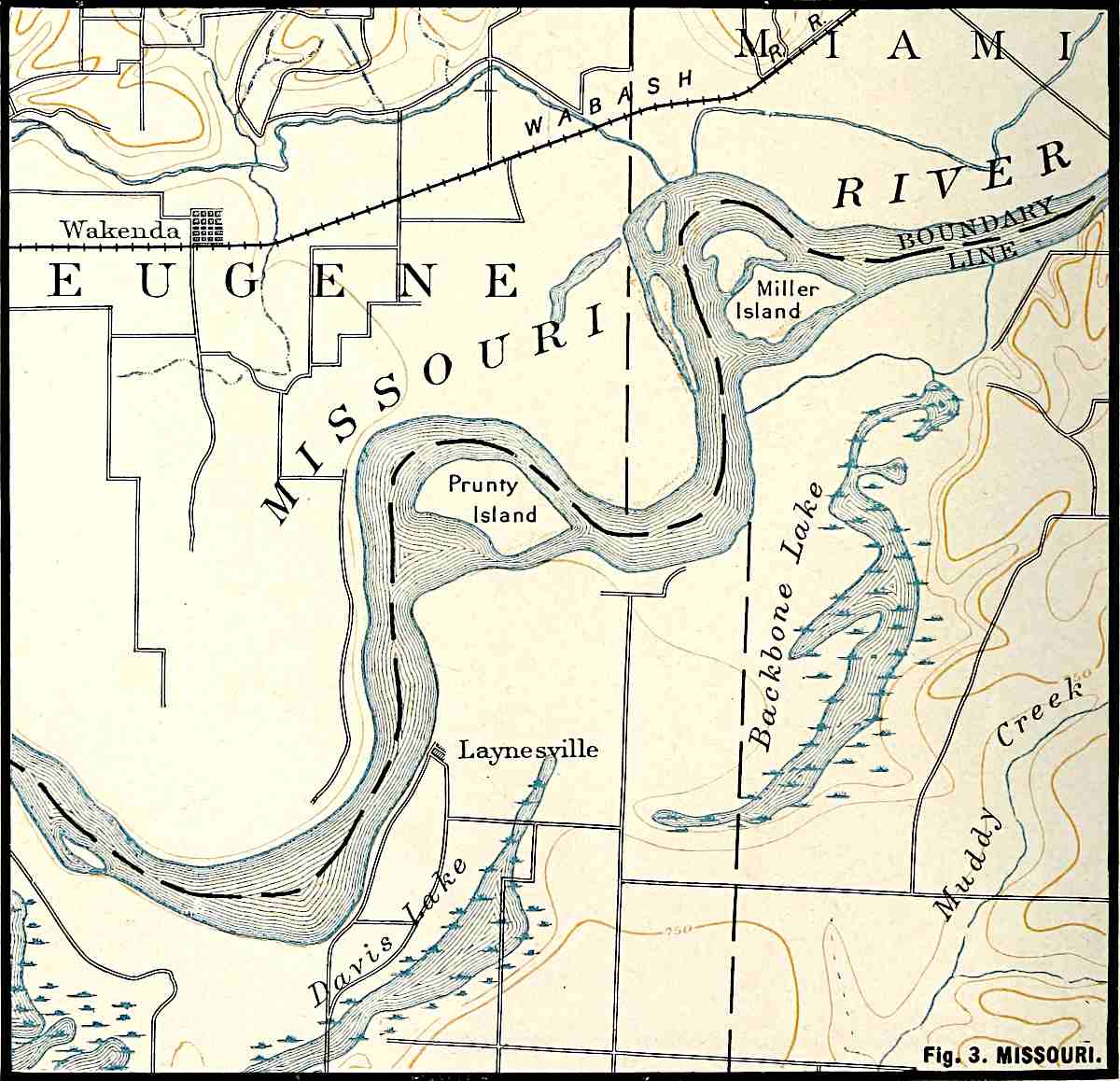
Flood-plain meanders. Cut-and-fill.—A stream with an alluvial plain is likely to meander widely (Pl. XVI). In general terms this may be said to be the result of low velocity, which allows it to be easily turned aside. Were the course of such a stream made straight, it would soon become crooked again. The manner of change is illustrated by Figs. 180 and 181. If the banks be less resistant at some points than at others, as is always the case, the stream will cut in at those points. If the configuration of the channel is such as to direct a current against a given point, a (Fig. 180), the result is the same, even without inequality of material. Once a curve in the bank is started, it is increased by the current which is directed into it. Furthermore, as the current issues from the curve, it impinges against the opposite bank and develops a curve at that point. The water issuing from this curve develops another, and so on.
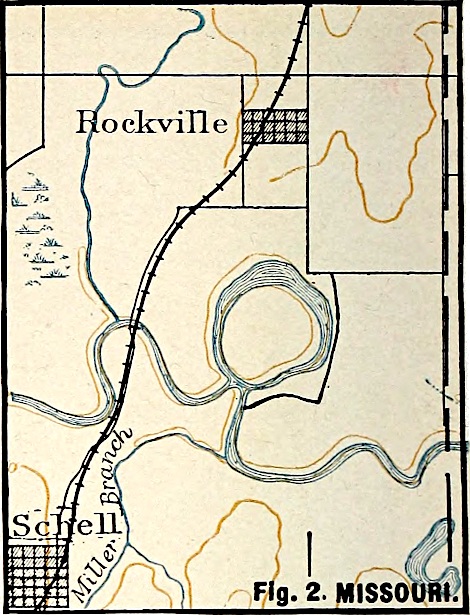
Once started, the curves or meanders tend to become more and more pronounced (compare Figs. 180 and 181). In the case represented by Fig. 1, Plate XVI (Missouri River near Brunswick, Mo.) the narrow neck of land between curves is almost cut through. When this is accomplished, the stream will abandon its wide curve. A later stage in the process is shown in Fig. 2, Plate XVI (the Osage River near Schell, Mo.).
The straightening of the channel is often accomplished in another way. Even before the meanders reach the stage represented by Fig. 1, Plate XVI, the position of the channel becomes unstable. In time of flood, the whole flat is covered with flowing water. The greater depth of water in the channel tends to give it a velocity greater than that of the water on the flat outside. But the distance from a to c via b (Fig. 181) is much greater than that in a direct line. It follows that the slope from a to c direct is greater than that by way of b. If the current between a and c in time of flood be strong enough to erode, it may deepen its bed, and thereby increase the volume of water following this course. The increased volume gives increased velocity, and the result may be the opening of a channel between a and c direct. The channel may be worn so deep that when the flood subsides, the stream will follow it. So long as the abandoned channel-curve remains unfilled with sediment, it is often called a cut-off. If it contains standing water and has the proper form, it is called an ox-bow lake (Fig. 182), or sometimes a bayou. The water-filled portions are not always bows (Fig. 183, Osage River, near Butler, Mo.). Cut-offs, with or without standing water, are of common occurrence along most rivers with wide plains. Meandering is not confined to streams which are near sea-level. Even small creeks at high altitudes may meander, if so situated as to have slight velocity. Trout Creek in the Yellowstone Park (Fig. 184) is an example.
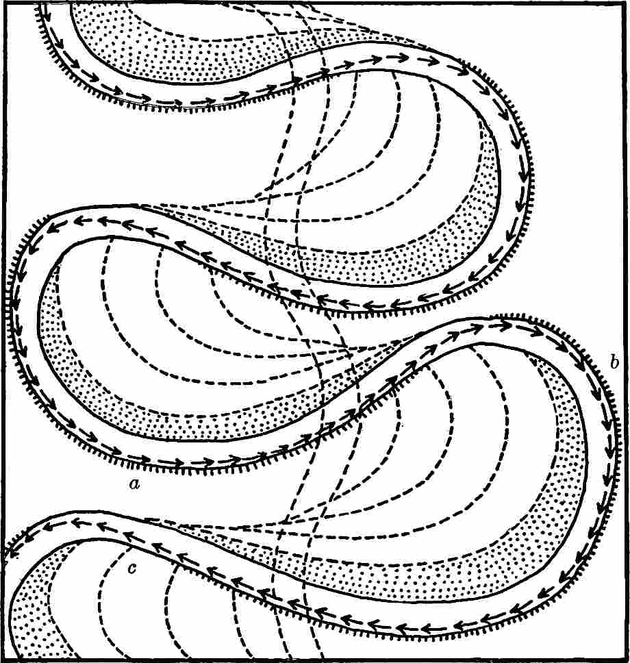
Fig.
181.—Diagram illustrating later stages in the development of meanders.
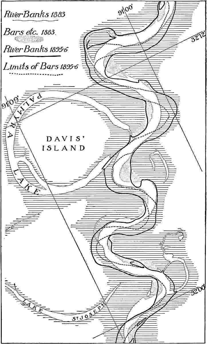
Fig.
182.—Meanders and cut-offs (ox-bow lakes) in the Mississippi Valley a little below Vicksburg. The figure also shows the migration of meanders down-stream, and their tendency to increase themselves. (From charts Nos. 18 and 19, Mississippi River Commission.)
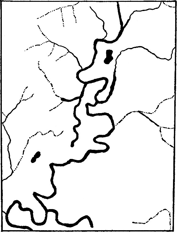
Fig.
183.—Bayou Lakes, Osage River, near Butler, Mo.
There seems to be some relation between the width of the belt within which a stream meanders, and the width of the stream itself. Recently it has been estimated that the ratio between them is 18:1.[72]
During the development of the meanders it is to be noted that lateral planation on the one side of a stream is accompanied by deposition on the other. This is cut-and-fill. The sediment eroded from the curve which is concave toward the stream is shifted down-stream, while that deposited in the curve which is convex toward the stream is brought down from above. Thus even in the development of meanders, the material which is dislodged is shifted down-stream. Since the current directed against the down-stream side of a growing meander is on the average stronger than that directed against the opposite side, the meander itself has a tendency to migrate down-stream (Fig. 182).
In their evolution, the curves of a stream’s channel often reach and undermine the valley bluff (Pl. VII). Since the meanders are, on the average, shifted down-stream individually, and since meanders are frequently developed in new places, it follows that a meandering stream tends to widen its valley throughout. Widening is also effected in other ways, for a stream with a flood-plain sometimes abandons its channel altogether for miles at a stretch, and the new course chosen may be against one of the bluffs of the valley. Such changes are most likely to take place where deposition along channel and levees has brought the part of the flood-plain (though not necessarily the bottom of the channel) adjacent to the stream above the level of that farther from it (Fig. 178). The change is likely to be effected in time of flood.
Flood-plains often attain great size. That of the Mississippi below the Ohio (Fig. 179) has a width ranging from rather more than 20 miles at Helena (Ark.), to something like 80 miles in the latitude of Greenville (Miss.).[73] Below the Ohio its area is something like 30,000 square miles, and its entire area has been estimated at about 50,000 square miles.[74]
Theoretically, the rotation of the earth should affect the erosion of streams, increasing it on the one bank (the right in the northern hemisphere and the left in the southern) and decreasing it on the other.[75] The streams doubtless accommodate themselves to the rotation of the earth in the original development of their gradation-plains and flood-plains, and the later effects of rotation are usually inconspicuous.
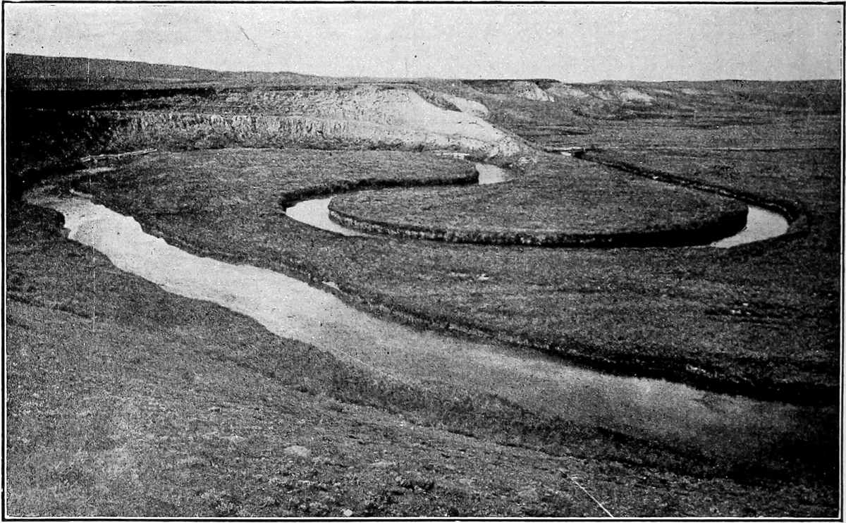
Fig.
184.—Meanders of Trout Creek, Yellowstone Park. (Walcott,
U. S. Geol. Surv.
)
Scour-and-fill.—It has already been shown that aggrading streams cut laterally at the same time that they build up their plains. It is now to be added that they periodically deepen their channels to a notable extent, and that the deepening of the channel takes place at the very time when the flood-plain is being aggraded. In other words, the stream in flood aggrades its plain, and degrades its channel. This follows from the fact that the current is sluggish in the former position, where the water is shallow, and rapid in the latter, where it is deep. When the flood subsides, the channel, deepened while the current was torrential, is filled again by the feebler current which follows. This alternate deepening and filling is known as scour-and-fill. It is well illustrated by the Missouri River. At Nebraska City, scour is believed to occasionally reach depths of 70 to 90 feet.[76] At Blair, about 25 miles above Omaha, the same river is believed to cut to bed-rock (about 40 feet below the bottom of the channel in low water) twice a year, that is, during floods.[77] Fig. 185 shows the changes recorded in the channel of the river at this point during the year 1883. It shows that the scour-and-fill during this year amounted to almost 40 feet. All streams similarly situated do a like work. The material thus eroded is shifted down-stream, some of it for short distances only, and some of it to the sea. Even an aggrading stream therefore is not without erosive activity; it is a stream whose fill exceeds its scour, not one which has ceased to erode.
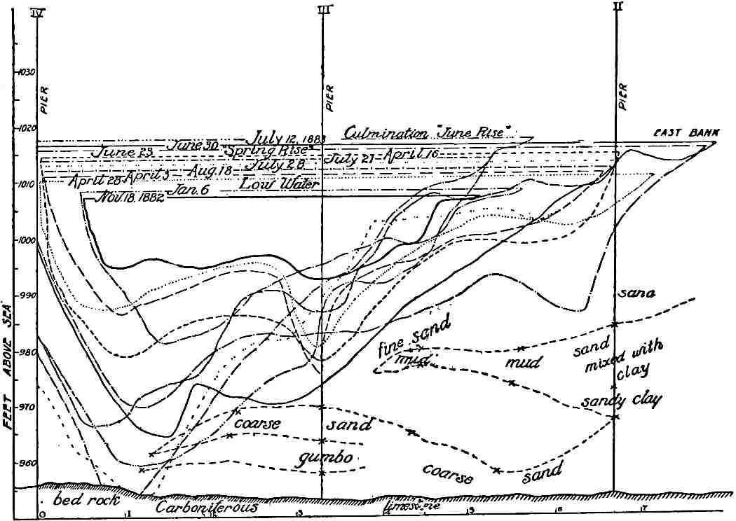
Fig.
185.—Diagram illustrating scour and fill in the Missouri River. A record of soundings at Blair Bridge (near Omaha), 1883. Shows also the cross-sections of the river at various rates. (Todd,
Bull.
158,
U. S. Geol. Surv.
)
Materials of the flood-plain.—As a result of its varying velocities in flood and low water, a stream may deposit coarse material at one time and fine at another. A similar sequence of deposits takes place in the flood-plain of a meandering stream, irrespective of floods. Flood-plain deposits are often therefore very heterogeneous, as shown in Fig. 186, which represents the constitution of the alluvium of the Missouri River at Omaha. The deposits of the streams range from the finest clay, through sand to gravel, and even bowlders. In general they become finer down-stream. In a given plain, they are usually coarser below and finer above.
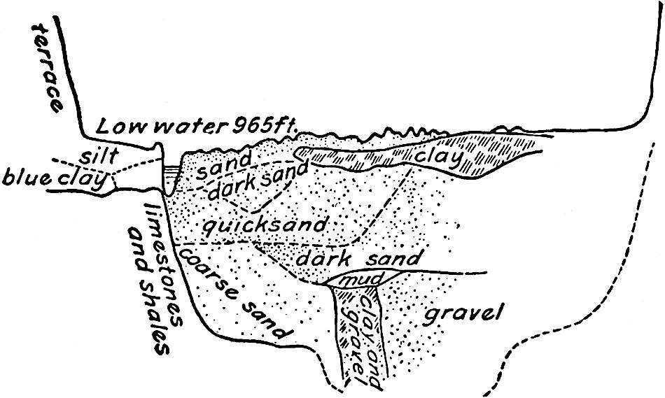
Fig.
186.—Diagram to show the heterogeneous character of alluvial deposits. (Todd,
Bull.
158,
U. S. Geol. Surv.
)
Topography of the flood-plain.—The flood-plain is nearly, but not altogether, flat. It has a gentle slope down-stream, and often for a distance from the sides toward the center (Fig. 174). This latter slope is the result of deposition by waters descending to the plain from the sides. It is destroyed wherever a meandering stream reaches its bluffs. When levees are well developed, there is a slope from them toward the sides of the valley (Fig. 178), but it rarely continues to the limiting bluffs. Since a stream with a well-developed flat frequently shifts its course, old levees and abandoned channels lend variety to the topography of the flood-plain.
The topographic adjustment of tributaries.[78]—The meandering and shifting of a main stream affects its tributaries. If a main stream swings against the bluff through which a tributary enters, the latter brings its channel into topographic adjustment by lowering its end to the level of the main. If now the main stream opposite the tributary swings to the other side of its valley, the tributary must make its way across the flat with a very low gradient. Not only this, but the flat of the main valley through which the tributary must flow is likely to be aggraded by the main in time of flood. The result is that the tributary stream becomes an aggrading stream at its debouchure, and topographic adjustment is not established until it has filled up the lower end of its valley to some notable extent. The filling of the lower end of the tributary likewise affects the lower ends of its lower tributaries.
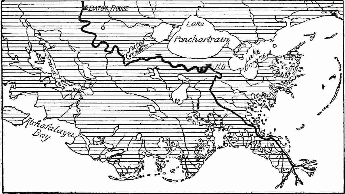
Fig.
187.—A general view of the Mississippi delta.
If the main stream again swings over to the point where the tributary issues from its valley, the tributary stream and all its affected tributaries again become eroding streams. Thus scour-and-fill are not confined to the valley of the main stream.
River-lakes.—While rivers are in general hostile to lakes, they sometimes give origin to them. Oxbow lakes (Fig. 182 and Pl. XVI), due to the cut-offs of meandering streams, have already been referred to. Lakes formed in the same way have other forms (Pl. XVI and Fig. 183). Rivers also give rise to lakes through the deposits they make. If a main stream obstructs its tributaries by deposition at their debouchures, their lower courses are ponded and converted into lakes. The lakes along the tributaries to the Red River of Louisiana have already been cited as examples. If a tributary brings more load to its main than the latter can carry away, the detritus constitutes a partial dam, ponding the river and causing it to expand into a lake above. Such is the origin of Lake Pepin already referred to. In mountain regions, the alluvial cones of tributary valleys sometimes pond their mains.
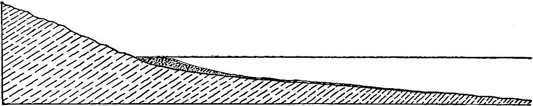
Fig.
188.—Longitudinal section of an incipient delta made of coarse material.
Rivers may be dammed in other ways, as by lava flows, by landslides, by glacial drift, etc. In all such cases, lakes may come into existence, but they are not due primarily to the activity of the river itself.
Deltas.[79]—Where a stream enters standing water, or a slower stream, a special form of plain, the delta, is sometimes built up (Figs. 169, 187, and 188). Deltas and alluvial fans have much in common, and their only notable differences are those imposed by the differences in the conditions of deposition. The current of the stream is checked, but not altogether stopped, at its immediate debouchure. If it carries abundant sediment, much of it will be promptly dropped where the decrease in velocity is first felt. Such flow as there is beyond the debouchure is not confined to a definite channel, and the deposits made are therefore spread more or less on either side of the line which represents the continuation of the stream’s course.
As the depth of the water into which the stream flows increases, the current diminishes. Out to the point where the depth of the standing water is less than the depth of the current, the latter affects the bottom, and the surface of the deposits made slopes gently seaward; but where the depth of the standing water is such that the projected stream current is ineffective at the bottom, all the load rolled along the bottom is dropped, and a depositional slope is established (Fig. 188), its upper edge being below sea-level by an amount corresponding roughly to the depth of the current which brings the detritus. The outer slope is relatively steep and well-defined where the detritus is coarse, and relatively gentle and ill-defined where it is fine. Thus the stream tends to construct a sort of platform in the water just beyond its debouchure. The successive deposits on the outer abrupt slope will dip conformably with its surface (Fig. 189). The finest sediment will be carried beyond the steep slope, and conform to the topography of the bottom beyond (c, Fig. 189).
At the beginning, the top of the delta platform is at the level of the bottom of the stream’s channel at the point of debouchure, but it is gradually aggraded as water continues to flow over it. Its landward margin is presently built up to sea-level and then above it, and as the delta grows the delta-land is extended seaward (compare Figs. 188 and 189). At the same time the channel of the stream above the original head of the delta is aggraded, for the current there is checked by the aggradation of the delta. Thus alluvial deposits continuous with the delta are extended landward.

Fig.
189.—Longitudinal section of the delta at a later stage of development.
The projection of the direction of the lower end of the stream may be said to be the axis of the extra-debouchure current. From this axis, where the flow is strongest, the movement diverges more or less to right and left. Since the velocity of the diverging water is reduced more rapidly than that of the water which follows the axis of flow, deposition is likely to take place faster on either side of the axis than along the axis itself. The result is that the extra-debouchure current tends to build up levee-like ridges on either side, making a sort of sluice-way for itself. This sluice-way is gradually extended seaward, and at the same time gradually filled. As its capacity is reduced, more and more of the water flows over its sides. Presently the escape of the water over the little side-levees will develop a break at some point, and a line of distinct flow then diverges from the main current. This distributary repeats the history of its main. Thus the processes of levee-building, channel-filling, and levee-breaking follow one another, until some such system of currents as shown in Fig. 190 is developed. The result is that a delta’s growth is not simply in the line of extension of the main stream, but in a more or less semicircular area, the center of the circle being a point slightly below the position of the debouchure of the stream when the delta began. At any stage in its development the margin of the delta is more or less crenate (Fig. 191), or characterized by delta fingers (Fig. 190), the projections corresponding to the positions of the debouchures of the latest streams flowing across it. The extreme ends of the delta lobes (Fig. 190), and of groups of the delta fingers, often have something of the shape of the Greek letter from which the name originated, but the resemblance in form between a well-developed delta and the Greek letter is not striking. Deltas are sometimes built in bays, and in such cases their forms are predetermined on all sides but one. The head of a delta is sometimes arbitrarily located at the point where the first distributaries are given off. Since this point shifts widely with time, the definition can hardly be accepted. On this basis the head of the Mississippi delta is about 200 miles above its lower end. In reality it is much farther north.
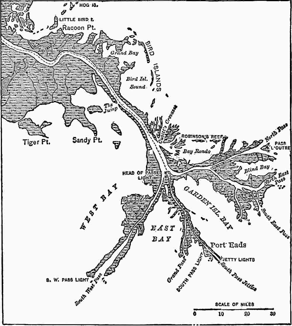
Fig.
190.—The terminus of the delta of the Mississippi. (C. and G. Survey.)
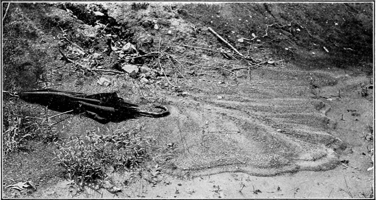
Fig.
191.—A miniature delta.
The structure of a delta, shown in Fig. 189, shows its history. At any stage in its growth the river discharges its sediment across that part of the platform already built. The sediment rolled at the bottom of the current is dumped on reaching the steep slope, and constitutes the inclined fore-set beds shown in Fig. 189. The material in suspension is carried farther, settles more gradually, and constitutes the bottom-set beds (c, Fig. 189). In time the bottom-set beds, originally deposited some distance beyond the debouchure, may come to be overlain by the fore-set beds, deposited at a later time. While the fore-set beds are being deposited on the steep slopes of the delta, and the bottom-set beds beyond, deposition is also taking place on the top of the delta. These top-set beds are laid down in a nearly horizontal position, and their seaward margin is gradually extended. Thus the delta comes to have the threefold structure shown in Fig. 189.
That part of the delta which is above the abrupt slope of its front corresponds in all essentials to an alluvial fan; but the delta as a whole differs from the fan in its abrupt and crenate or digitate margin.
It is to be noted that the delta is not wholly the product of a stream’s activity. The stream supplies the material, but the lake or sea renders at least passive assistance in its disposition. Not all rivers opening into the sea build deltas, and their failure is often the result of waves or shore currents which carry off the river sediment. Deltas are, however, sometimes formed in tidal seas, as at the debouchures of the Yukon; the Mackenzie, where the tidal range is three feet; the Niger, where the range is four feet; the Hoang-Ho, where the range is eight feet; and the Brahmaputra and Ganges, where the range is sixteen feet.[80] Since lakes, bays, gulfs, and inland seas have weaker waves and currents than the open sea, they are more favorable than the latter for the growth of deltas. Hence occur such deltas as those of the Mississippi, the Nile, the Po, and the Danube.
Deltas are likely to be absent, or confined to the heads of bays, on coasts which have recently sunk. Their general absence on the Atlantic coast of the United States is a case in point.
The following figures give some idea of the extent of deltas, and of their importance in land building. The Mississippi delta is advancing into the Gulf at the rate of about 100 yards per year, or a mile in 16 or 17 years. Its length is more than 200 miles, its area more than 12,000 square miles, and its depth at New Orleans has been estimated at 700[81] to 1000[82] feet. This great depth is believed to be the result of subsidence, and so of the superposition of one delta on another.[83] The delta of the Yukon has a sea margin of 70 miles, and extends more than 100 miles inland. The delta of the Rhône has also had a remarkable growth, considering the size and the history of the stream. Arles, near the debouchure of the stream, was 14 to 16 miles inland in the fourth century b.c., and is now 30 miles inland.[84] The Rhône has also built a great delta in Lake Geneva, and its lower delta is built of sediment gathered below the lake. The Po has built a delta 14 miles beyond Adria, the port which gave its name to the Adriatic Sea. The extension of this delta has been at the average rate of about 50 feet per year, but recently, on account of artificial embankments, the rate has been much more rapid.[85] The Ganges and Brahmaputra together have made a delta of great size. Its area is sometimes estimated to be as high as 50,000 or 60,000 square miles, and its head is more than 200 miles from the sea.[86] The head of the Nile delta is 90 miles from the sea, and it has a coastal border of 180 miles. The head of the delta of the Hoang-Ho is about 300 miles from the coast, and its seaward border has a length of about 400 miles, though with some highland interruptions.[87]
After a delta has been built into a lake, the lake may disappear, leaving the delta out of water. Such “fossil” deltas, if so recently exposed that erosion has not destroyed their distinctive features, are readily recognized by their flat tops, their abrupt and lobate fronts, and their characteristic structure. They are often a means of determining the former existence of extinct lakes,[88] or the former higher levels of lakes which still exist.[89] Elevated deltas on seashores show either a rise of the land or a depression of the sea-level.
The material which is carried along the coasts or shores from the mouths of rivers may take on various and peculiar forms, according to the strength, direction, and relations of waves and currents. The consideration of these forms belongs more properly to the work of the sea than to that of rivers, since rivers are not concerned in their construction except in supplying material.
Delta lakes.—Delta-building streams sometimes help to form lakes by throwing their deposits around an area which fails to be aggraded to sea-level. Lake Pontchartrain, and other lakes in the delta of the Mississippi are examples (Fig. 187).
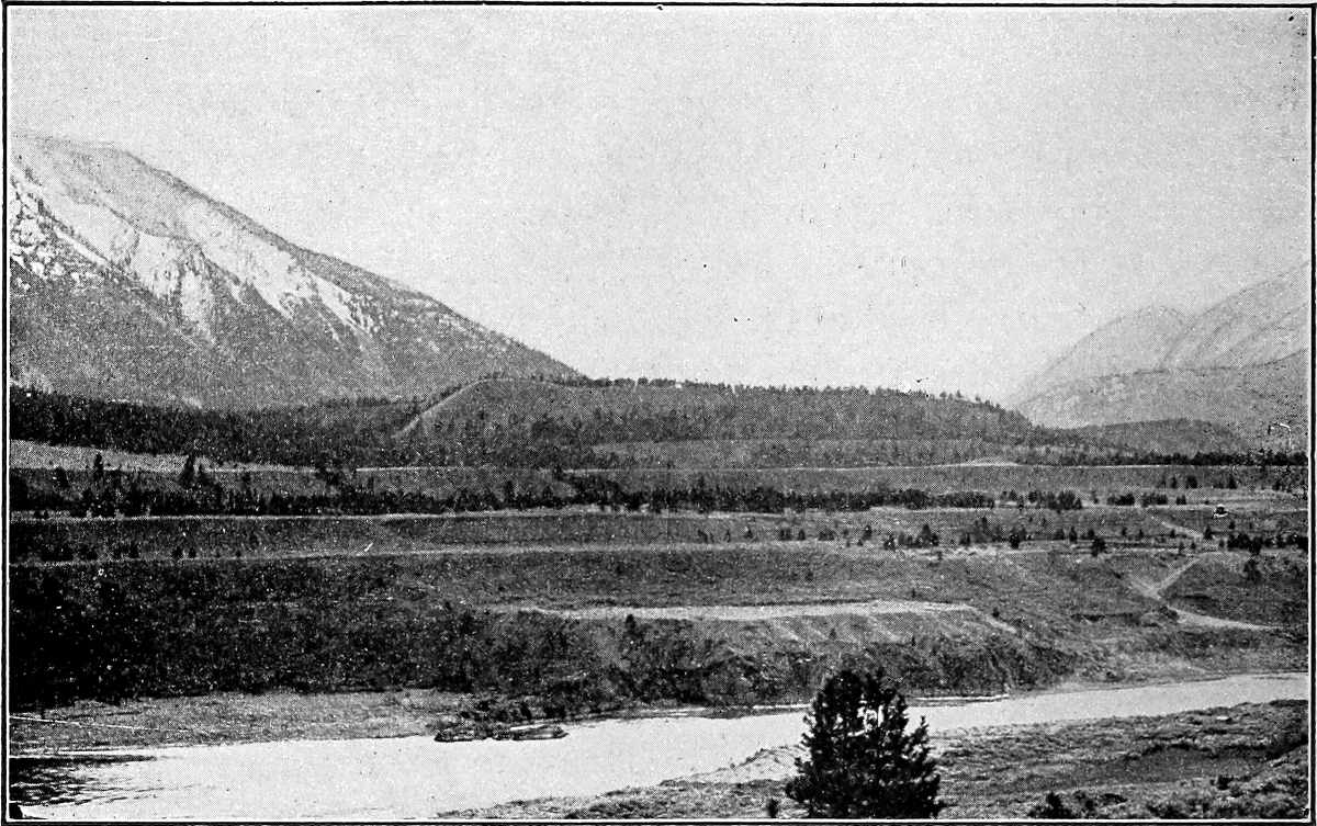
Fig.
192.—Terraces of the Frazier River at Lillooet, B. C. (Calvin.)
STREAM TERRACES.
Stream terraces[90] are bench-like flats or narrow plains along the sides of valleys (Fig. 192). They are usually narrow, but sometimes have great length in the direction of the axis of the valley. They originate in various ways.
Due to inequalities of hardness.—Reference has already been made (p. 140) to the effect of hard horizontal layers in the development of terraces and terraciform projections on the sides of valleys (Fig. 120). Such terraces are the result of differential degradation, and the upper surface of the hard layer marks the lower limit of the terrace, which commonly has a distinct slope toward the stream. Except where interrupted by tributary valleys, such terraces are likely to be continuous in a valley so long as the structure remains the same and the stream sustains the same relation to it. Such terraces would first show themselves in the older part of the valley. The effect of inclination of the hard stratum on the development of such terraces will be readily inferred. Terraces and benches of this sort are not equally distinct at all stages of a valley’s history. For great distinctness, the hard layer should have been exposed long enough to allow the general processes of erosion to have effected considerable differential wear, but not long enough to allow the topographic effects of unequal resistance to be obliterated.

Fig.
193.—Diagram illustrating a distinct terrace and a “second bottom (
b
),” which may be regarded as a low terrace.
Normal flood-plain terraces.—It has been seen that deposition in a river valley stands in more or less definite relationship to the stage of its development, and that the deposition which leads to the development of an alluvial plain is likely to take place where the higher gradient of the upper course gives place to the gentler gradient of the lower. It has also been seen that as a stream’s history advances, the stretch where the gradient is high recedes up-stream, and that the point which marks the head of active deposition follows. It follows that a river flat or flood-plain normally begins in the lower part of a valley, and works progressively headward, its upper end following, at some considerable distance, the head of the valley itself.
The commoner river terraces are remnants of former flood-plains, below which the streams which made them have cut their channels. It has already been pointed out (p. 184) that processes of erosion and deposition work together in the development of flood-plains, and that some flood-plains have but little alluvium (Fig. 174), while others owe their origin wholly to stream deposits (Fig. 175). It follows that terraces developed from flood-plains may be of rock, of alluvium, or of rock covered with alluvium.
The amount which a river channel must be deepened in order to change the remnants of its flood-plain to terraces cannot be definitely stated. When a channel is so deep that the remnants of a former flood-plain are no longer flooded, they would be called terraces, especially if a lower flood-plain has been developed. Even though not above the reach of floods, they are often called terraces if they are notably above the channel and separated from it by a lower plain. Thus the flat at b, Fig. 193, would be called a terrace, even though covered by water in exceptional floods; but the flat at c, but slightly above the channel, would hardly be called a terrace.
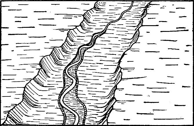
Fig.
194.—Diagram illustrating the beginning of the development of a terrace from a flood-plain.
The question now arises why a stream, having once developed a flood-plain, should sink its channel to a lower level, leaving parts of the old flood-plain as terraces. This may be brought about by the operation of various causes.
(1) In the first place, the head of the valley-plain where the first notable deposition takes place normally advances up-stream. After the advance has been considerable, the descending stream may, on reaching the head of its valley-plain, lose so much of its load as to be able to sink its channel into the flood-plain farther down the valley (Fig. 194).
(2) Ordinarily a stream does not drop all its load at the head of its plain, but only its excess; but it will always drop coarse sediment to take fine, if fine be available. For a relatively small amount of coarse material dropped, a relatively large amount of fine may be taken up (p. 179). Other things being equal, it follows that when a stream drops coarse material to take fine, its channel is degraded unless there is at the same time a great reduction in the stream’s energy. Such reduction is likely to go with the decreasing declivity down-stream; but this is partly, or sometimes wholly, counterbalanced by the increasing volume of water. By the exchange of load, therefore, a stream may ultimately sink its channel below the flood-plain which the earlier and perhaps smaller stream had developed.
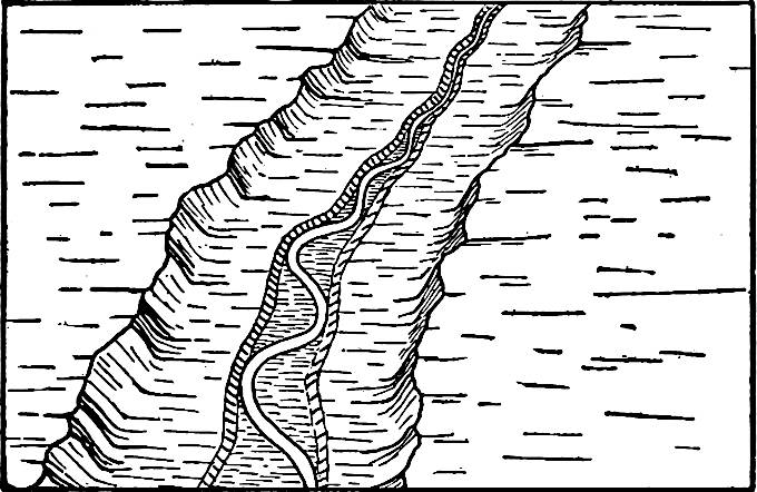
Fig.
195.—Diagram to illustrate the development of river terraces by the widening of a channel or meander belt. The valley flat above might not be called a terrace; but the same plain below, where the meander belt has some width, would be called a terrace.
(3) Again, so long as a stream is actively eroding at its head, there is likely to be some aggradation below. At a later stage in the stream’s history, when active erosion at the head has ceased because of the reduction of the surface, less material will be carried from the upper part of the valley, and the stream on the flood-plain below, formerly loaded with material from up the valley, is now free to take up and carry away material temporarily left on the flood-plain. The result is a deepening of the channel.
(4) Any stream which has reached the flood-plain stage is likely to meander. After the flood-plain has become wide, the width of the belt within which the stream meanders is less than the width of its plain. In the Lower Mississippi, for example, the meander belt is often no more than a third to a tenth of the width of the flood-plain. It has already been pointed out that the meanders migrate down the valley. In so doing they depress the meander belt, the tendency being to reduce it to the level of the channel, and, therefore, below the level of the flood-plain. As the meander belt widens, the depression which it develops becomes more and more capacious. Presently it may attain such dimensions as to hold the water of ordinary floods. At this stage, or even before, such parts of the earlier flood-plain as remain, are terraces.
These several tendencies conspire to partially destroy river flood-plains, and to transform such parts as remain into terraces in the normal course of a river’s history. They appear first in the lower part of the valley, and migrate headward, following the course of nearly every other phase of activity in a stream’s history. The heads of the terraces follow, at a respectful distance, the head of the flood-plain, just as the head of the flood-plain follows at a distance the head of the valley. The second and subsequent flood-plains and the terraces to which they give origin follow the same course.
Terraces developed by the normal activities of a stream are always low, and it is improbable that they would ordinarily be conspicuous. The vertical distance between the first (highest) and second is greater than that between the second and third. The principles developed on page 65 et seq., in connection with the erosion of the hypothetical island, are applicable here.
Flood-plain terraces due to other causes.—Certain other causes, accidental rather than normal to a stream, result in the development of terraces from flood-plains. (1) If there be uplift in a region where the rivers have flats, the streams are rejuvenated, and the remnants of their former flood-plains become terraces. (2) If an alluvial flood-plain has been built as the result of an excessive supply of sediment (p. 186), the exhaustion or withdrawal of the excessive supply would leave the stream again relatively clear, and free to erode where it had been depositing. It would forthwith set to work to carry away the material which it had temporarily unloaded on the plain. The plains built up in many valleys in the northern part of our continent during the glacial period, when the drainage from the ice coursed through them, have subsequently been partially destroyed by erosion, and their remnants have become terraces. A notable reduction in the amount of available sediment, even when the earlier supply was not excessive, produces a similar result. (3) A notable increase in the volume of a stream, without corresponding increase in load, as when one stream captures another, may occasion the development of terraces by allowing the stream to deepen its channel. (4) Above any barrier which dams a stream, a flood-plain is likely to be developed. When the barrier is removed the stream will cut more or less deeply into the plain above, leaving terraces. (5) The recession of a falls through a flood-plain converts such parts of it as remain, into terraces.
In conclusion, it may be stated that many river terraces, mostly very low, are normal features of valley development, coming into existence at definite stages in a valley’s history. They are generally composed, in large part, of river alluvium. Others result from more or less accidental causes, working singly or in conjunction, and to this class belong all of the more conspicuous terraces developed from flood-plains. The structure of a terrace often affords some clue to its origin (Fig. 196).

Fig.
196.—Terraces partly of rock and partly of alluvium. Such terraces indicate successive uplifts, or some other change which had a similar effect on the stream which made the valley.
Discontinuity of terraces.—When a stream sinks its channel into its flood-plain, it does not follow that a terrace remains on each side. Where the stream’s deepened channel is in the middle of its flood-plain, there is, temporarily, a terrace on either side; but wherever the deepened channel is at one margin of its flood-plain, a terrace remains on the other side only. Even where continuous at the outset, terraces soon become discontinuous, for all processes of subaërial erosion conspire to destroy them. A stream is likely to meander on its second and later flood-plains, as on its first and highest one. Wherever the meanders on its second flood-plain reach the borders of the first flood-plain, the terrace at that point disappears, and since the meanders are continually migrating, terraces are continually disappearing. The same would be true of the second terrace, if a second were developed. The removal of portions of a terrace by the sweep of meanders is likely to leave the remnants cuspate toward the stream.[91] Again, tributary streams, in bringing their channels into topographic adjustment with their mains, cut through the terraces of the latter. New gullies develop on the faces of the terraces and their heads work back across them, dissecting them still further. At the same time, sheet erosion and other phases of slope wash tend to drive the scarps of the terraces back toward the bluff beyond. By the time a second series of terraces is well developed, no more than meagre remnants of the first may remain.
From the foregoing considerations it is clear that the extent to which river terraces once developed, now remain, is dependent in part on the length of time which has elapsed since the river sank its channel below them. Other things being equal, the greater their age the more meagre their remnants.
Terraces developed from river plains formed chiefly by alluviation stand a better chance of long life than most other alluvial terraces. This is because of the configuration of the original valley, the aggradation of which gave origin to the plain. The principle involved is illustrated by Fig. 197. In developing the second flood-plain the river encounters the rock wall of the valley. This greatly retards lateral erosion, and the terrace above, defended[92] by the rock, is likely to be long-lived.

Fig.
197.—Diagram to show why certain terraces are longer lived than others.
Alluvial terraces, like rock shelves, are popularly thought to mark “old levels of the river.” In one sense this is true, but not in the sense in which the expression is commonly used. Every level, from the crest of the bounding bluffs to the bottom of a valley, is a level at which water ran for a longer or shorter time; but the terrace does not mean that the river was once so much larger than now as to fill the valley from its present channel to the level of the terraces.
Termini of terraces.—From the mode of development of terraces it will be seen that, traced up-stream, each terrace should theoretically grade into a flood-plain at its upper end (Fig. 194), and that the upper end of the second (from the top) terrace, where there are two, would not be so far up-stream as the upper end of the first (highest). This is represented diagrammatically in Fig. 198.
The down-stream termini of terraces are rarely distinct. This is partly because the notable meandering of the streams in their lower courses is antagonistic to the preservation of terraces. If all terraces once developed remained, and if delta-building proceeded without interruption from waves, the relations should be somewhat as follows: Traced down-stream, the cliff between the oldest (highest) terrace and the next younger becomes gradually lower until it finally disappears, and the continuation of the two is found in a common plain. The cliff between the second and third terraces should disappear in the same way, and below its disappearance the plain representing their continuation is continuous with that representing the continuation of the first and second. The cliff between the second and third terraces may or may not continue farther down-stream than that between the first and second. The plains below the terraces finally become continuous with the lowest flood-plain and with the delta. These relations can rarely be seen because of the destruction of the older terraces, and because of the erosion by waves along shore.
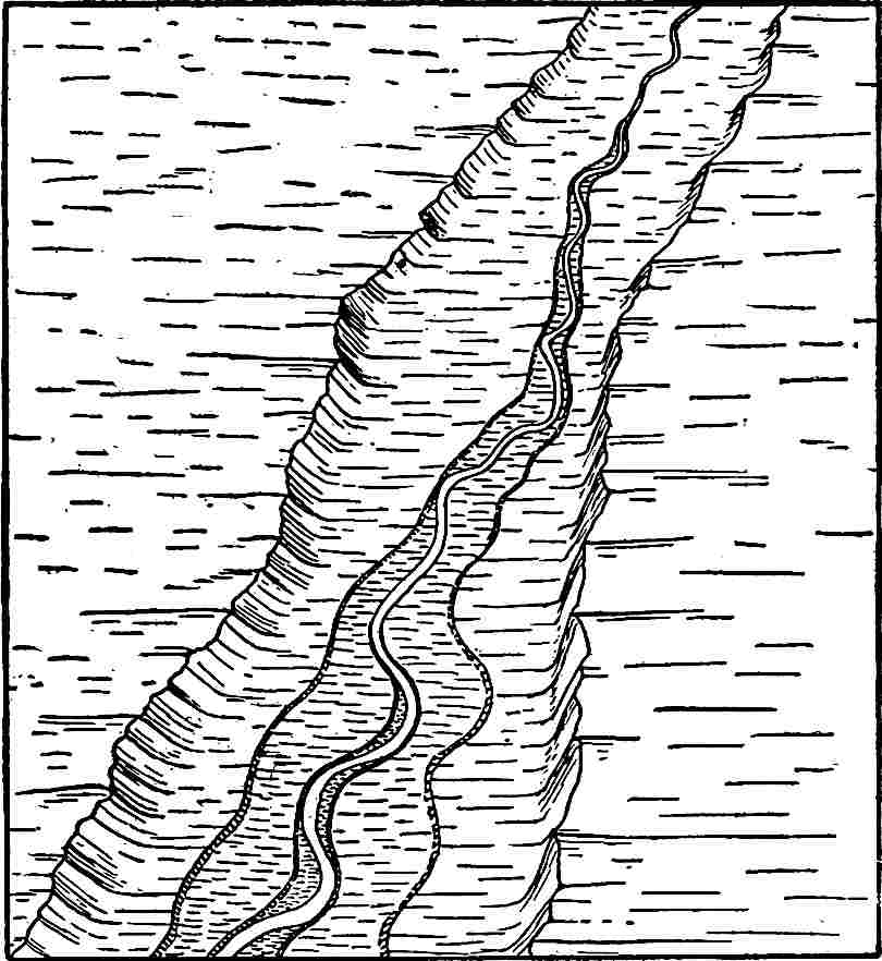
Fig.
198.—Diagram looking up the valley, showing two terraces below, one in the middle, and none above. The relations are purely diagrammatic.
The topography of terraces is similar to that of flood-plains, except in so far as modified by erosion. While flat in general, the terrace may slope either toward or from the valley bluff, and its surface may be marked by all the minor irregularities which characterize a flood-plain.