Chapter VI
Reading edition
THE WORK OF THE OCEAN.
The general facts concerning the depth of the ocean and the distribution of its water have been given on a preceding page (p. 8), and the origin of the ocean and the ocean basins is discussed in the second volume. This chapter has to do primarily with the processes now going on in the sea and its borders, in so far as they are of importance in the interpretation of geologic history. The study of these processes is prefaced by a few words concerning the amount and composition of the sea-water, the life of the ocean, and the topography of its bed.[138]
Volume and composition.—Every 1000 parts of sea-water contain about 34.40 parts by weight of mineral matter in solution. The principal solids, acids, and bases, combined according to the principles laid down by Dittmar, are shown in the following table:[2]
Chloride of sodium 77.758
Chloride of magnesium 10.878
Sulphate of magnesium 4.737
Sulphate of calcium 3.600
Sulphate of potassium 2.465
Bromide of magnesium 0.217
Carbonate of calcium 0.345
————
Total salts 100.000
Expressed in terms of tons per cubic mile of sea-water, the composition is as follows:[139]
Tons per Cubic Mile.
Chloride of sodium (NaCl) 117,434,000
Chloride of magnesium (MgCl2) 16,428,000
Sulphate of magnesium (MgSO4) 7,154,000
Sulphate of calcium (CaSO4) 5,437,000
Sulphate of potassium (K2SO4) 3,723,000
Bromide of magnesium (MgBr2) 328,000
Carbonate of calcium (CaCO3) 521,000
—————
For sea-water, total dissolved matter 151,025,000
Aside from the ingredients shown in the above tables, the presence of the following has been proved: iodine, fluorine, phosphorus, silicon, boron, silver, lead, copper, zinc, cobalt, nickel, iron, manganese, aluminum, barium, strontium, arsenic, lithium, cæsium, rubidium, and gold. Oxygen, nitrogen, and carbonic acid gas are also present in quantity. The amount of carbonic acid is estimated to be 18 times as great as in the atmosphere.[140]
The amount of sea-water is estimated by Murray at 323,722,150 cubic miles,[141] or about 15 times the volume of the land above sea-level. The volume and composition of the sea-water being known, the amount of mineral matter which it contains may be readily calculated. Assuming the average specific gravity of the mineral matter in solution to be 2.5, the 3.5% by weight becomes 1.4% by volume, and 1.4% of 323,722,150 cubic miles is 4,532,110 cubic miles. This then represents the aggregate volume of mineral matter in the sea if it were precipitated and compacted so as to have an average specific gravity of 2.5. Assuming the average depth of the sea to be 2076 fathoms (12,456 feet), as given by Murray, the mineral matter in solution, if precipitated, would cover the ocean bottom to a depth of about 175 feet. Assuming the area of the land to be to that of the sea as 28 to 72, this amount of mineral matter would make a layer about 450 feet deep over the land. Its amount is equal to about 20% of that of all lands above sea-level, and it falls but little short of that in all lands below 600 feet in altitude. If it were precipitated and concentrated in the shallow waters about the borders of the lands, it would fill the sea out to the depth of about 4000 feet, and would diminish its area by some 19,000,000 to 20,000,000 square miles, an area which is more than ⅓ of the present land surface. In other words, if the mineral matter in the sea-water were precipitated and concentrated in the shallow waters about the lands, it would restore the continental shelves to the land areas, and add an almost equal area beyond.
These comparisons may perhaps help to give some idea of the amount of mineral matter in solution in the sea, but they give no more than a hint of the importance of the solvent power of water in the general processes of rock decay, for most of the substances carried to the sea in solution by rivers are extracted from the water about as rapidly as they are supplied. Thus calcium carbonate is about twenty times as abundant as sodium chloride in river-water,[142] but is only ¹⁄₁₂₅ as abundant in sea-water.
The total river discharge into the sea is estimated at 6524 cubic miles of water per year.[143] This water is estimated to carry to the sea annually about half a cubic mile of mineral matter in solution. At this rate it would take about 9,000,000 years for the streams to bring to the sea an amount of mineral matter equal to that it now contains, but the proportions of the ingredients would be very different.
The sodium chloride makes up about 2.4% of the mineral matter in river-water and nearly 78% of the mineral matter of the sea. At this rate it would take nearly 300,000,000 years for the salt of the sea to have been contributed by the rivers. It is not to be understood, however, that this figure indicates the age of the ocean. The salt is not all brought in by the rivers; the rivers have probably not always contributed at the present rate; and much salt once in the sea has been precipitated. Nevertheless the above figure gives some suggestion as to the order of magnitude of the figures which represent the age of the ocean.
In contrast with the salt, the amount of calcium carbonate in the sea is so small that at their present rate of contribution, it would be brought to the sea by rivers in about 62,000 years.
Topography of bed.—The general relations of ocean basins to continents are suggested by Fig. 296. The borders of the continental platforms are covered by the epicontinental sea, while the abysmal sea occupies the ocean basins proper. From the figure it is seen that an ocean basin is pronouncedly convex upward, and so departs as widely as may be from the current notion of the homely utensil from which it is named. Only when it is remembered that a level surface (on the earth) is one which has the mean curvature of the earth, and that the deeper parts of the ocean basin are well below the mean sphere level, does the current name seem justified.[144] The figure also shows that the depth of an ocean basin is slight compared with the radius of the earth.
The bed of the ocean, like the face of the land, is affected by elevations and depressions, and its deepest points are about as far below its surface as the highest mountains are above it. There are areas of the sea bottom which, as a whole, may be compared to the plains of the land, and others which may be likened to plateaus, and the lines of gradation between them are as indistinct as they often are on the land. There are mountain peaks, chiefly of volcanic origin, and depressions comparable to the great basins on the land. But apart from these general features, there is little in common between the topography of the sea bottom and that of the land. Mountain systems are, for the most part, absent, though certain islands, like Cuba and some of its associates, may be regarded as the crests of systems which are chiefly submerged. If the water were drawn off from the ocean’s bed so that it could be seen as the land is, its most impressive feature would be its monotony. The familiar hills and valleys which, in all their multitudinous forms, give the land surface its most characteristic features are essentially absent. A large part of its surface would be found to be so nearly flat that the eye would not detect its departure from planeness.
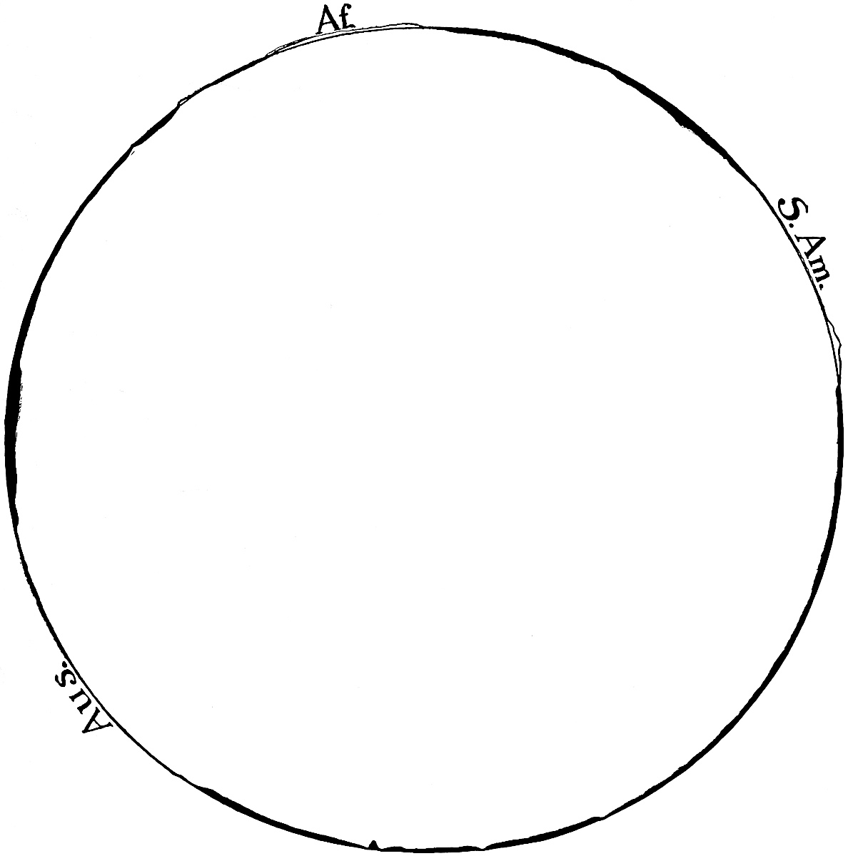
Fig.
296.—General relations of ocean basins to the lithosphere.
Lat.
20° S. Depth of the water (black) and height of land exaggerated ten times. (Data from Murray, Scot. Geogr. Mag.,
Vol.
XV, 1899.)
The reason for this profound difference is readily found. On the land, the dominant processes which shape the details of the surface are degradational, and though the final result of degradation is flatness (base-level), the immediate result is relief, and, most commonly, relief of the hill-and-valley type. In the sea, the dominant processes are aggradational, and tend to monotonous planeness.
Distribution of marine life.—Marine life has been of such importance in the history of the earth that the elementary facts concerning its distribution and the principles which control it are here recalled. The distribution of marine life is influenced by many factors, chief among which are temperature and depth of water. Not only is life more abundant in the warmer parts of the ocean than in the colder, but the species inhabiting cold waters are different from those in warm, and few species range through great variations. Many forms of life are restricted to shallow water. Many more, especially those which do not live on the bottom, swim about freely without reference to the depth of the water beneath them, while relatively few are restricted to great depths. Many species are also influenced by the salinity of the water, which varies notably along coasts where the fresh waters from the land are discharged; by the character of the sediment at the bottom, some species preferring mud, others sand, and others gravel; by the movement of the waters, some species preferring still waters and others rough; and some species by the abundance and nature of the food-supply, and by rival and hostile species.
Subject to the exceptions determined by temperature, etc., plant life abounds in shallow water out to depths of 100 fathoms or so, and is found in abundance at the surface where the depth is much greater. Animal life abounds in shallow water, both at the bottom and above it, out to depths of 200 or 300 fathoms, and occurs in great profusion in the surface-waters of temperate and tropical regions without regard to the depth. The great body of the ocean water lying below a depth of some few hundred fathoms is nearly tenantless, though life reappears sparingly at the bottom, even where the depth is great. For further discussion of this topic, see Chapter XI.
PROCESSES IN OPERATION IN THE SEA.
Within the area of the sea, as on the area of the land, three sets of processes are at work—diastrophism, vulcanism, and gradation.
Diastrophism (p. 2) affects the sea-bottom as the land, but the results are notably different in certain respects. So far as the lithosphere is concerned, the sea-level may be said to be the critical level. At and above it, many processes are in operation which do not appear below, and below it, many which do not take place above. Changes of level which do not involve the submergence of areas which were land, or the emergence of areas which were under water, are relatively unimportant, compared with those which effect such changes. The rise of the bottom of the sea from a depth of 500 fathoms to a depth of 200 fathoms would not lead to important consequences, so far as the area itself is concerned, while an equal rise of the bottom beneath 200 fathoms of water, or an equal subsidence of land 500 feet high, would be attended by more striking consequences. It follows that the changes effected by diastrophism are much more obvious along coasts than in the deep seas. Emergence or submergence shifts the zones of aggradation and degradation, shifts the zone of contact of ocean and land, and changes the region concerned from one appropriate for sea life to one appropriate for terrestrial forms, or vice versa.
Over the continental shelves the water is shallow and the bottom relatively smooth. If a coastal region be elevated evenly, or if the sea-level be drawn down, the new shore-line on the smooth surface of the former submerged shelf will be relatively regular, even though the coast was notably irregular before the change. Thus in Fig. 297 the coast-line is notably irregular. A sea-withdrawal or a land-uplift of 120 feet would change the coast-line to the position of the 20-fathom line, when it would be notably less irregular than now. If it were shifted to the 100-fathom line, few irregularities would remain. In so far as new coast-lines formed by the lowering of the sea (or rise of the crust) depart from straightness, it is usually by broad, smooth curves. Local uplifts of coastal lands, and especially uplifts along axes normal to the trend of the coast, would give rise to projections of land, and so to coastal irregularities; but such uplifts are rarely so localized as to give origin to minor projections. It follows that rising coasts, and those which have recently risen, or more likely, coasts along which the sea-level is sinking or has recently sunk, are likely to be regular so far as details of outline are concerned. Subsidence of a coast-line (or rise of the sea-level) tends to the opposite results, for in this case the sea advances on a surface which has more or less relief, and the water takes possession of every depression brought to its level. The lower parts of the valleys are converted into bays, the length and width of which depend on the slope and width of the valleys drowned. The numerous bays at the debouchures of the streams along the Atlantic coast of the United States, from Long Island Sound to Carolina, such as the Delaware, Chesapeake, (Fig. 297) and numerous smaller bays, are the results of recent sinking, which has allowed the sea to invade the lower ends of river valleys. The ragged coast of Maine is another example, though glaciation as well as subsidence has been operative here. From the present configuration of coast-lines, it has been inferred that the present is, on the whole, an era of continental depression.[145] River valleys, the lower ends of which are embayed, are sometimes found to be continuous with submerged valleys beyond the coast-line (Fig. 298). Submerged river valleys show that the surface in which they lie was once land.
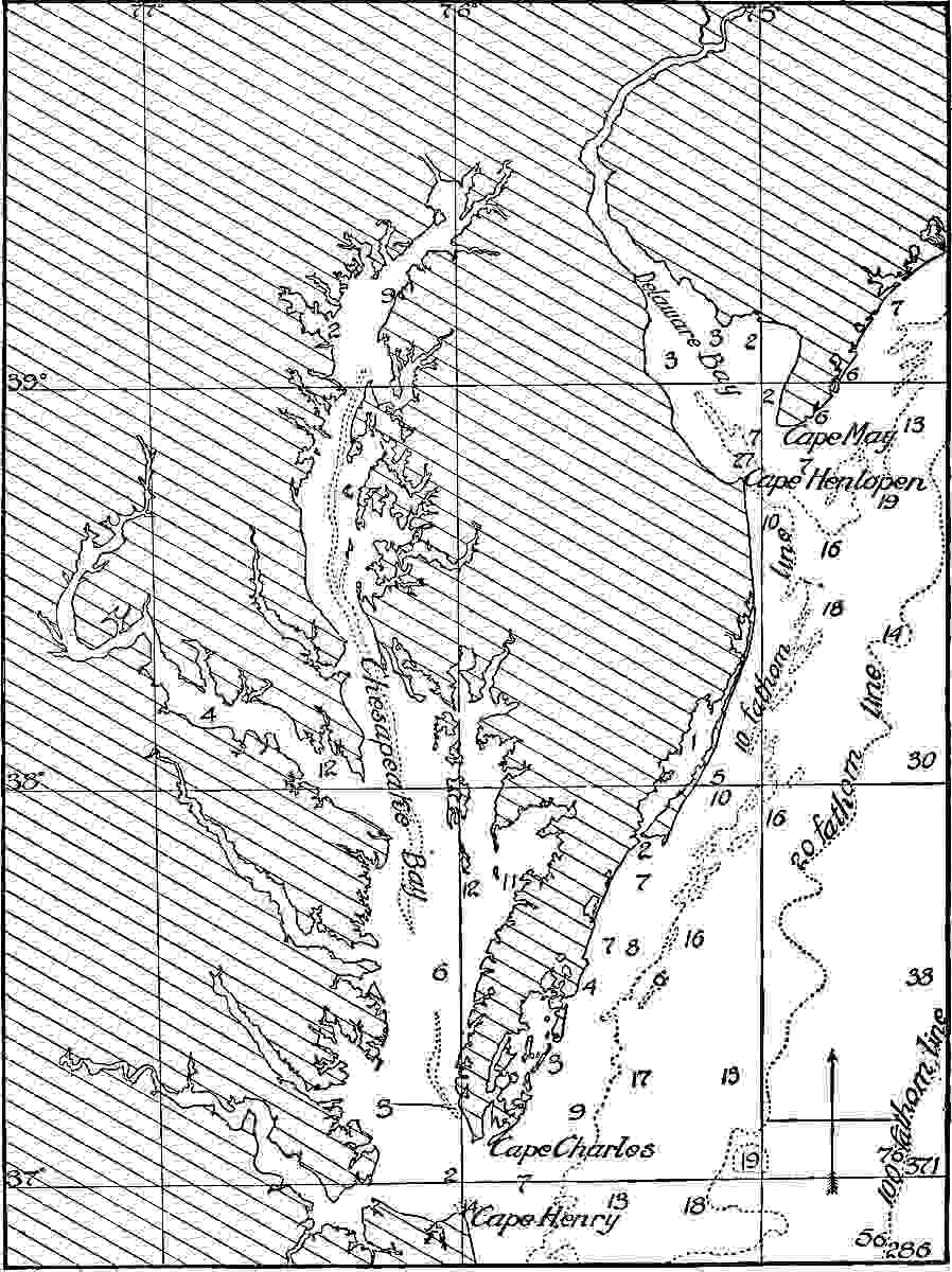
Fig.
297.—Sketch of the eastern coast of the United States from Cape May to Cape Henry, showing coastal irregularities. The figures represent the depths of water in fathoms. (From charts of C. and G. Surv.)
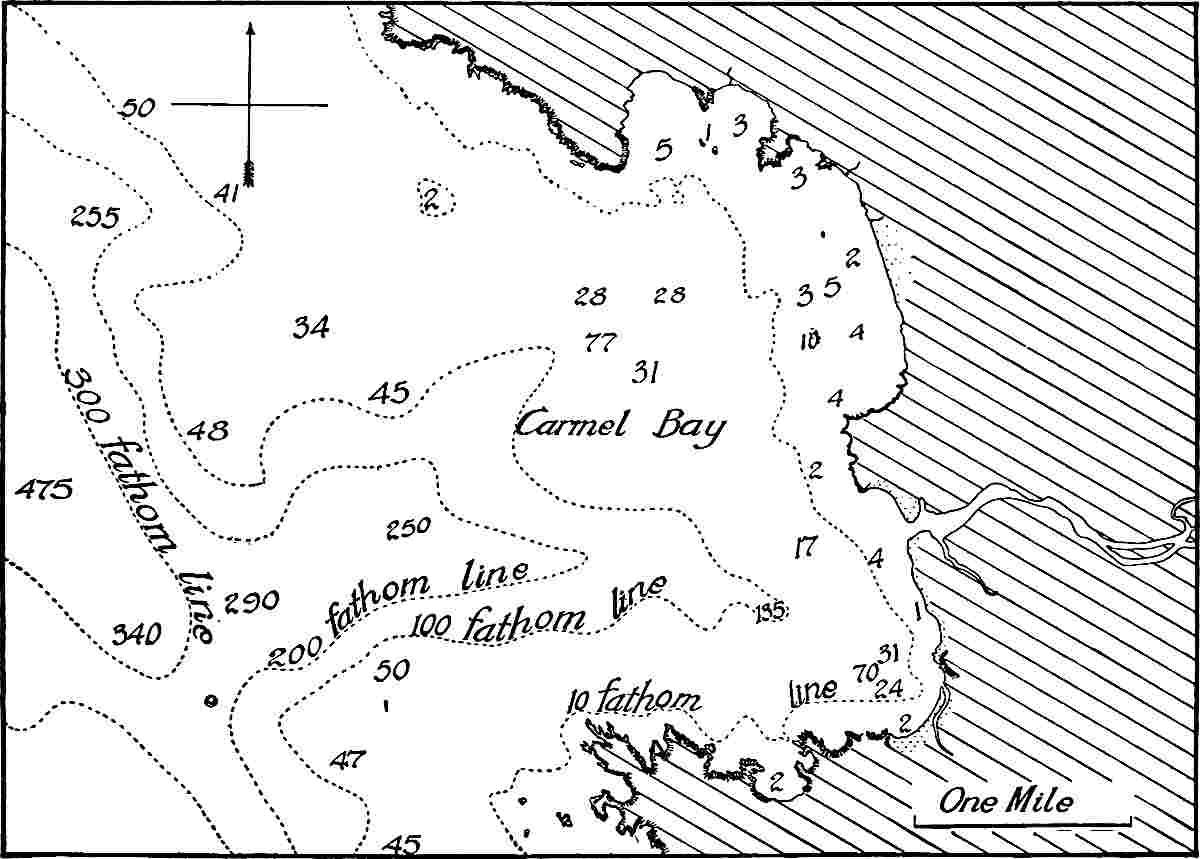
Fig.
298.—Sketch of Carmel Bay,
Cal.
The contours below sea-level show a deep submerged channel. (From charts of C. and G. Surv.)
Bays may be developed by local subsidence as well as by the submerging of valleys, though decisive examples are not readily cited. Bays may also be produced by uplift of the surface on either side of an area which does not change its level. For example, uplift on either side of the Gulf of California has probably been one element, though probably not the only one, in the development of this indentation. The general outline of a great bay produced by coastal warping might be regular, though it would be likely to be marked by small irregularities where the streams enter. It is not to be understood that all, or even most, bays are due to local diastrophism.
Diastrophism, then, as it affects the ocean-bottoms and the ocean-borders, may make the water of any ocean shallower or deeper; it may cause the emergence or submergence of land; it may make coast-lines regular or irregular; it may shift the habitat of life, and through these changes may greatly influence the processes of gradation, which are especially active along the contact of sea and land.
Vulcanism affects the sea-bottom much as it affects the land. At the volcanic centers, where the great body of extruded matter accumulates, mounds and mountains are built up. Most of the mountain peaks of the sea-bottom, whether their crests are islands, or whether they are wholly submerged, have had a volcanic origin. The rock material ejected from submarine vents is probably less widely distributed than that from vents on land, and so far forth, the volcanic cones in the oceans are steeper than those on land. Where volcanic cones are built up near the surface of the sea, they often furnish a home for shallow-water life, such as polyps. Wherever built up so as to be within the reach of waves, gradational processes are stimulated.
The processes of vulcanism do not commonly influence coasts of continents directly, for few volcanoes lie immediately on coasts. In places, however, as at various points in and about Italy, the configuration of the coast is influenced by the building of volcanoes. Indirectly, vulcanism influences the shape of coast-lines, for the resistance of igneous rock is often different from that of the rock with which it is associated, and under the influences of the forces of gradation it may come to form projecting points or reëntrants, as the case may be.
The number of active volcanoes on islands is about 200, or about two-thirds of all now known. Since the area of the sea is about three times that of the land, the known active volcanoes in the sea are rather less numerous per unit area than those on the land. The number of active vents beneath the sea is altogether unknown. A few submarine eruptions have been observed, and those observed are probably but a small percentage of those which have taken place in historic time. Slight eruptions in deep water might not manifest themselves at the surface in an unequivocal way, even were observers stationed near them. Volcanic cones which fail to reach the surface are known, and the forms of many sea-bottom mountain peaks are such as to make it probable that they are volcanic. These phenomena, as well as the numerous volcanic islands, give some indication of the importance of submarine eruptions in past time.
Ocean volcanoes, and especially submarine volcanoes, affect both the temperature and the composition of the sea-water. Both the increase of temperature and the solution of volcanic gases increase the capacity of the water for mineral matter, and both the change in temperature and composition affect the life of the adjacent waters. The destruction of life during eruptions occasions the generation of the products of organic decomposition, and these stimulate further chemical changes. The diffusion of affected waters occasions chemical changes wherever they go. The effects of oceanic volcanoes on the sea-water are, therefore, appreciable, when long periods of time are considered. The deposition of the finer parts of volcanic discharges will be considered in connection with the deposits of the deep sea.
Gradation.—The gradational processes of the land and the sea are in striking contrast. On the land, degradation predominates, and aggradation is subordinate. In the sea, aggradation predominates, and degradation is subordinate. On the land, degradation is, on the whole, greatest where the land is highest, while aggradation is of consequence only where the land is low, or where steep slopes give place to gentle ones. In the sea, degradation is virtually confined to shallow water, or to what might be called the highlands of the sea, while aggradation is nearly universal, but most considerable in shallow water, or where shallow water gives place to deep. Both the degradational and aggradational work of the sea are greatest near its shores. Opposed as the gradational work of the land and sea are, they yet tend to a common end—the leveling of the surface of the lithosphere.
The gradational processes which affect the sea-bottom may be divided into three categories: (1) Those effected by mechanical means, (2) those effected by chemical means, and (3) those effected by organic agencies.
The mechanical work of gradation in the sea is effected chiefly by the movements of the water, and, very subordinately, by the movements of the ice which the water carries. The results of these movements may be degradational wherever the water is sufficiently shallow for the motion to affect the bottom. Elsewhere it is aggradational.
The direct gradational work effected by chemical means is likewise partly degradational and partly aggradational. If at any time or place the water becomes supersaturated with any mineral substance, precipitation takes place, and the precipitate accumulates as sediment on the bottom. This sometimes happens in lagoons and other small inclosures, and perhaps in open water. On the other hand, wherever solution is effected, degradation is the result. Solution is most important where the bottom consists of relatively soluble rock, such as lime carbonate.
Organic agencies are, on the whole, aggradational. Accumulations of coral, coral débris, shells, etc., help to build up the sea-bottom, and most rapidly in shallow water where the proper forms of life are most abundant. Here also should be mentioned the accumulations of carbonaceous matter, especially in the form of plant bodies. In the aggradation effected directly by organic agencies, the sea is passive. Its only part is to support the life which gives rise to the solid matter, and incidentally to float a part of it in its currents.
MOVEMENTS OF THE SEA-WATER.
The movements of the sea-water fall into several categories. There is (1) a general circulation of sea-water, determined chiefly by three factors: differences in density in the sea-water, differences of level, and the general movements of the atmosphere; (2) periodic movements which are not primarily circulatory, brought about by the attraction of the sun and moon; and (3) aperiodic movements, due to occasional causes, such as earthquakes, volcanic explosions, landslides, etc., which determine local and temporary movements, often of exceptional strength.
Differences in density and their results.—Differences in density result from differences in temperature and salinity. Temperature alone considered, water would be densest where it is coldest, namely in the polar regions. Differences in salinity result from differences in evaporation and from inequalities in the supply of fresh water. Evaporation alone considered, the sea-water should be densest where evaporation is greatest; but the equatorial region, where evaporation is greatest, is also a region where precipitation is heavy, and precipitation, by freshening the water, opposes the effect of great evaporation. The greatest differences in density due to the unequal supply of fresh water are to be found near the borders of continents, where the precipitation on the land is discharged into the sea. In the polar regions, the great supply of fresh water, especially during the season when the ice is melting, opposes the effect of the low temperature, so far as the density of the water is concerned. The result of the operation of these factors affecting the density of the sea-water is to insure a general circulation, directed to the end of equalizing the densities; and since the disturbing factors are constantly in operation, equilibrium is never established, and the movements of the water are perpetual.
The pressure gradients resulting from differences of density are so slight that the resulting movements are scarcely more than a creep of the waters. In general they are far too slow to be of importance in gradational work; but the earth’s rotation deflects the creeping waters and tends to concentrate the equator-ward movement into currents on the east sides of the continents, and the pole-ward movement on the west sides. In favorable situations these currents may be competent to produce sensible mechanical results. Even where this is not the case the circulation helps to equalize the temperatures of the sea, and so of the air above and of the land about. Indirectly, therefore, the circulation of the ocean-waters affects every geological process which is sensitive to climate.
Differences in level and their results.—While the surface of the ocean is the common datum plane to which elevations and depressions are referred, it is to be remembered that the sea has “a very complicated undulating surface in consequence of the attraction which the heterogeneous and elevated portions of the lithosphere exercise on the liquid hydrosphere. In the opinion of geodesists, the geoid may in some places depart from the figure of the spheroid by 1000 feet.”[146] These variations in level would, however, not occasion circulation. The differences in level which determine circulation are much more trivial. Every stream which pours fresh water into the sea tends to raise the level of the water where it enters. The waters brought to the ocean by the Amazon, the Mississippi, and other great rivers would appreciably change the level of the sea at their debouchures, if the excess did not promptly flow away. The ready mobility of the water, however, prevents its accumulation, and the discharge of every stream generates widespread movement. This movement is strongest at the debouchure, and weakens with increasing distance from it, though in the case of great streams, such as the Amazon, the movement is traceable, by means of the sediment which the water carries, hundreds of miles out to sea.
Changes of level are also brought about by the winds, which pile up water along the shore against which they blow. The level of the water is said to have risen 24 feet at Calcutta on October 5, 1864, as the result of a severe storm. While this is exceptional, a rise of 2 feet is not rare. This piling up of the waters along shore insures a compensating movement (undertow, littoral currents, etc.) in some other direction. Unequal evaporation and precipitation likewise disturb the level of the sea and occasion movement. In the open sea the movements generated by differences of level, like those generated by differences of density, are chiefly slow, creeping movements, but movements which never cease. In bays and gulfs, on the other hand, the surface of the water may be so raised, either as the result of wind, river discharge, or heavy precipitation, as to give rise to strong outward currents. There is little doubt at the present time that the Gulf Stream owes its origin primarily to the difference of level between the Gulf of Mexico and the Atlantic.[147]
Movements generated by winds.—The circulation resulting from the tendency of the winds to change the level of the sea-water has already been mentioned, but the wind also works in other ways. Where the winds have a somewhat constant direction and are at the same time strong, they determine a general movement of the surface-waters in their own direction, the surface-water being dragged along at a rate somewhat less than that of the wind itself. The constant trades appear to be the chief generators of the equatorial ocean-currents. Once generated, these currents may be concentrated and their courses modified. The currents generated by trades are turned north and south when directed against a continent; they are modified by the configuration of the bottom if the water be shallow, and always and everywhere, except, at the equator, they are deflected by the rotation of the earth, in the northern hemisphere to the right, and in the southern to the left. The pole-ward currents generated in the equatorial region by the trades, and directed by the winds, the lands, the configuration of the bottom, and the rotation of the earth, determine compensating currents from high latitudes to low, and the same influences which control the course of the former direct the latter as well.
Since the atmospheric movements are so far constant that there is a prevailing direction of winds in all latitudes, the winds, as well as differences of density and differences of level, insure a general and continual circulation of sea-water. The geological effects of this circulation are direct and indirect; direct, by gradation of the bottom over which they flow, and indirect, by the modifications of climate they produce. Since rotation deflects the pole-ward currents to the east sides of the oceans (west sides of the continents) and the equator-ward movements to the west sides of the oceans (east sides of the continents), the east shores of the oceans are warmer than the west in corresponding latitudes, and the west sides of the continents are both warmer and moister[148] than the east sides.
The most obvious disturbance of sea-water resulting from the winds is the generation of waves. Waves are not primarily parts of the general oceanic circulation. Since they are generated in other ways than by winds, and since the gradational effects of waves are independent of their origin, the effects of wind-waves will not be considered separately.
Movements generated by attraction.—One of the movements of the sea-water which is not primarily circulatory results from the attraction of the moon and sun. The tide is really the result of the inequalities of the attraction of these bodies on different parts of the earth. The lunar tide is more important than the solar, not because the attraction of the moon is greater, for it is not, but because its differential attraction, the result of its lesser distance, is greater.
The distance of the moon from the earth is about 240,000 miles. If this be taken as the distance from the center of the moon to the center of the earth, 236,000 and 244,000 miles respectively are the distances from the center of the moon to the nearest and most distant points on the earth. The distance of the sun from the earth is about 93,000,000 miles. If this be taken as the distance between the centers of these bodies, then the distances from the center of the sun to the nearest and most distant points on the earth’s surface are 92,996,000 and 93,004,000 miles respectively. The ratio of 4000 to 236,000 or to 244,000 is much greater than the ratio of 4000 to 92,996,000 or to 93,004,000. Hence the tide-producing force of the moon is greater than that of the sun.
The tides show themselves along shores in the form of waves which, in shallow water, become translatory. They differ from the wind-waves in their periodicity, and locally in their greater height. The effects of the tidal waves on the shores of the sea, and on the bottom in shallow water, are the same as the effect of wind-waves of equal strength, and need not be separately considered in connection with the gradation of the sea-bottom. In passing through narrow straits or narrow passes of any sort, the tidal movement becomes a current which, under favorable conditions, abrades or “scours” the bottom effectively. The tidal currents in the narrow passes about New York harbor may serve as an illustration.
Aperiodic movements.—In addition to the wind-waves which are essentially constant and universal, and to the tidal waves, which are periodic, there are accidental waves which are locally and temporarily of importance. Such are earthquake-waves, which are sometimes extremely destructive. Thus an earthquake-wave on the coast of Peru in 1746 swept a frigate several miles inland and deluged Lima, seven miles from the shore. The havoc of most earthquakes affecting coasts, such as that of Lisbon in 1755, is greatly aggravated by accompanying sea-waves. Earthquake-waves differ from ordinary waves in being translatory, and so in being more effective on the bottom in deep water. Their greatest force, however, is felt in shallow water and on shores. Volcanic eruptions likewise give rise to exceptional aperiodic waves. The same is true of landslides where they affect the coast or any part of the sea-bottom. The fall of glacier ends and the capsizing of icebergs likewise generate strong waves. To the category of exceptional waves also belong those generated by the winds of exceptional storms, such as that which devastated Galveston in 1900.[149]
Summary.—From the point of view of their direct geological results in shallow water, all movements of the sea-water may be grouped into two main classes—(1) waves, with the undertow and the littoral currents they generate, and (2) ocean-currents.[150]
WAVES.
Wave-motion.[151]—The most common waves, and from the present point of view the most important, are those generated by winds. During the passage of a wave, each particle affected by it rises and falls, and moves forward and backward describing an orbit in a vertical plane. If the passing wave is a swell, the orbit of the particle is closed and is either a circle or an ellipse; but in the case of a wind-wave the orbit is not closed. In such a wave two things move forward, the undulation and the water. The velocity of the undulation is relatively rapid; that of the water, slow and rhythmic. On the crest of the wind-wave each particle of water moves forward, and in the trough it moves less rapidly backward, and the excess of the forward movement over the backward gives it a slight residual advance. This residual advance is the initiatory element of current. By virtue of it, the upper layer of water is carried forward with reference to the layer below, in the direction toward which the wind blows. The waves of any considerable or long-continued wind, therefore, generate a current tending in the same direction as the wind.
The agitation of which waves are the superficial manifestation is not restricted to the surface, but is propagated indefinitely downward. Near the surface the amount of motion diminishes rapidly with increasing depth (Fig. 299), but the rate of diminution itself diminishes, and there seems no theoretic reason for assigning any definite limit to the downward propagation of the oscillation.
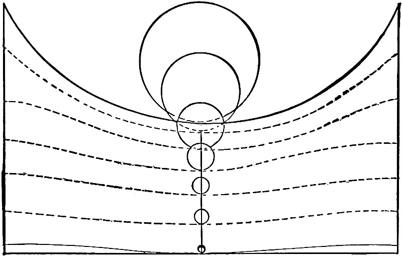
Fig.
299.—Figure illustrating the decrease in the amount of wave-movement with increase of depth. (Fenneman.)
At the surface, the radius of the circular orbit which a particle of water in a wave tends to describe is half the height of the wave. At a depth equal to one wave-length, the radius of the circle described by a particle is ¹⁄₅₃₅ as great as at the surface, and at a depth equal to two wave-lengths, ¹⁄₃₀₀₀₀₀. If the height of a wave be 43 feet, the radius of the circle described by a surface particle is 21½ feet. If the length of the wave be 300 feet, the radius of a particle at a depth of 300 feet is only about ⁴⁄₁₀ of an inch, and at 600 feet ¹⁄₁₂₀₀ of an inch.[152] These figures make it clear that effective agitation of the water does not extend to great depths.
So long as the velocity of the wind remains constant, the velocity of the current which the wind-waves generate is less than that of the wind, and there is always a differential movement of the water, each layer moving faster than the one beneath. The friction is thus distributed through the whole vertical column of the water in movement, and is even borne in part by the sea-bottom if the movement extends so far down. The greater the depth, the smaller the share of the friction each layer of water is called upon to bear, and the greater the velocity of the current generated by a given wind. But while the wave-motion extends indefinitely downward, the lower limit of agitation effective in erosion is soon reached. Engineering operations have shown that submarine structures are little disturbed at depths of five meters in the Mediterranean and eight meters in the Atlantic.[153] On the other hand, débris as coarse as gravel, which is transported by rolling on the bottom, is not infrequently carried out to depths of 50 feet, and sometimes even to 150 feet. Fine sediment, like silt, is disturbed at still greater depths, for ripple-marks, which indicate agitation of the water, are said to have been found at depths of 100 fathoms.[154]
When a wave approaches a shelving shore, its habit is changed. The velocity of the undulation is diminished, while the velocity of the advancing particle of water in the crest is increased; the wave-length, measured from trough to trough, is diminished, and the wave-height is increased; the crest becomes acute, with the front steeper than the back, and these changes culminate in the breaking of the crest, when the undulation proper ceases. Waves of a given height break in about the same depth of water, and the line along which incoming waves break is the line of breakers. The line of breakers is in deeper water and farther from shore when the waves are strong than when they are weak. Waves are reported to have broken in 100 fathoms of water,[155] but this must be regarded as very exceptional. The return of the water thrown forward in the crests of waves is accomplished by a current along the bottom called the undertow. The undertow is sensibly normal to the coast when uninfluenced by oblique waves, and is efficient in removing the products of erosion.
Since the incoming wave affects water which is at the same time under the influence of the undertow, it gives to that current a pulsating character, for the wave-motion sometimes supports and sometimes opposes the undertow, and thus endows it with a higher transporting power than belongs to its mean velocity. Near the breaker-line, the oscillations communicated by the wave may momentarily overcome and even reverse the movement of the undertow. Inside the breaker-line, irregular oscillation only is communicated. The broken wave-crest, dashing forward, overcomes the undertow and throws it back, and the water returns as a simple current descending a slope. The power of the undertow diminishes rapidly from the breaker-line outward as the depth of the water increases.
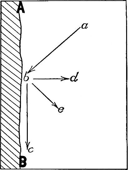
Fig.
300.—Diagram showing relative directions of wave, undertow, and shore-current.
When waves advance on the shore obliquely, a shore-current is developed as illustrated by Fig. 300, where ab represents the direction of the incoming wave, bc the direction of the littoral current, and bd the direction of the undertow. Where they strike the borders of land, the wind-waves, therefore, generate two other movements, the undertow and the littoral current. Any particle of water near shore may be affected by any two or by all three of these movements at the same moment. The effect of littoral current and undertow is to give a particle of water on which both are working a direction between the two, as be. The effect of other combinations can be readily inferred. These various combinations are of consequence in the transportation of débris.
WORK OF THE WAVES.
Erosion.
The general effects of the waves and the other movements to which they give rise along shores are (1) the wear of the shores; (2) the transportation for greater or less distances of the products of wear; and (3) the deposition of the transported materials.
By waves and undertow.—In the dash of the waves against the shore, the chief wear is effected by the impact of the water and of the débris which the water carries. Lesser results are accomplished in other ways.
When the land at the margin of the water consists of unconsolidated material, or of fragmental material but slightly cemented, the impact of the water is sufficient to displace or erode it. If weak rock be associated with resistant rock within the zone of wave-work, the removal of the former may lead to the disruption and fall of the latter, especially when weak rock is washed out from beneath the strong. The impact of the water is competent also to break up and remove rock which was once resistant, but which has been superficially weakened by changes of temperature. Rock affected by numerous open joints is likewise attacked with success, for by the dash of the waves the blocks between the joints may be loosened and literally quarried out. It may, however, be doubted whether the dash of waves of clear water, even when their force is many tons to the square foot, has any appreciable power to wear rock which is thoroughly solid.
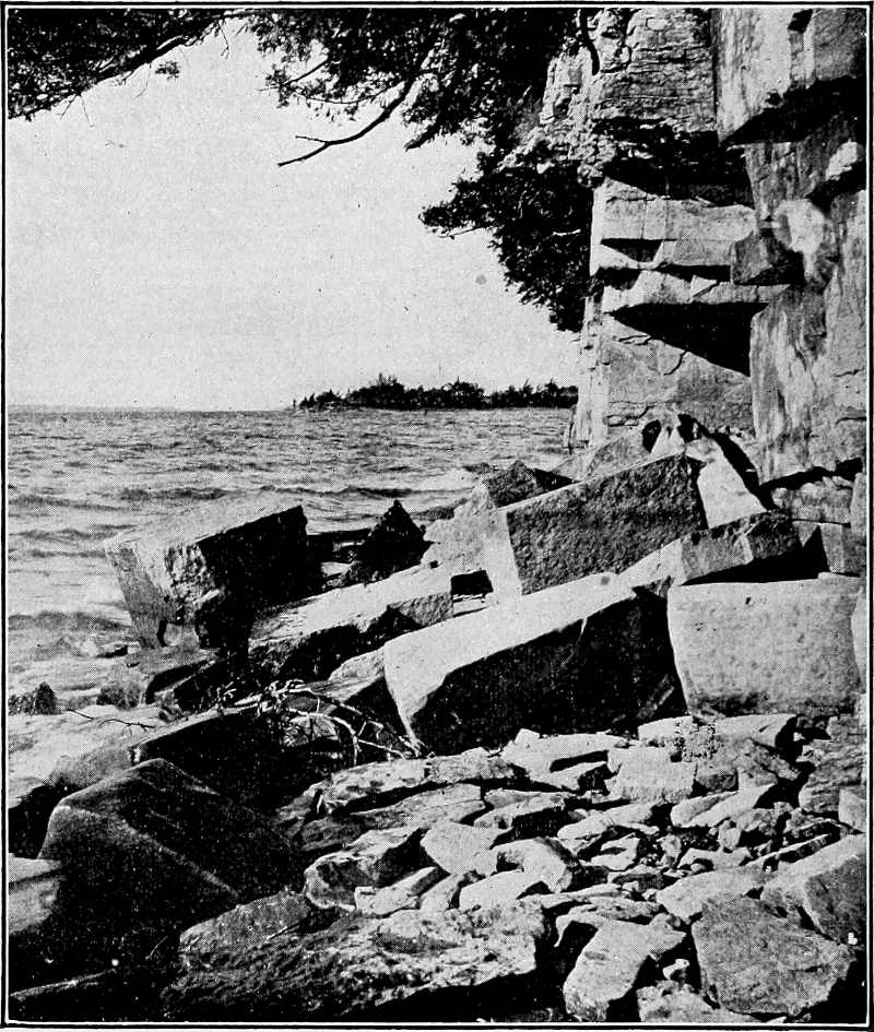
Fig.
301.—Angular blocks of rock which have fallen from the cliff above, as a result of undercutting by the waves. Grand Island, Lake Champlain. The rock is Black River limestone. Although from the shore of a lake instead of the sea, the principles illustrated are the same. (Perry.)
The impact of the waves is generally reinforced and made effective by the impact of the detritus they carry. The sand, the pebbles, and such stones as the waves can move are used as weapons of attack, being turned against one another and against the shore. Masses of rock too large for the waves to move (Fig. 301) are worn by the detritus
driven back and forth over them, and in time reduced to movable dimensions (Fig. 302). They then become the tools of the waves, and in use, are reduced to smaller and smaller size. Thus bowlders are reduced to cobbles, cobbles to pebbles, pebbles to sand, and sand to silt. The silt is readily held in suspension in agitated water, and thus is carried out beyond the range of breakers, and settles in water so deep as not to be effectively agitated to its bottom. Thus one generation of bowlders after another is worn out, and the comminuted products are carried out from the immediate shore and deposited in deeper water.
The effectiveness of waves, whether they work by impact of water alone, or by impact of water and detritus, is dependent on their strength and on the concentration of their blows.[156] The strength of waves is dependent on the strength of the winds (or other generating cause) and the depth and expanse of the water, and the concentration of their blows is conditioned by the slope against which they break. On exposed ocean-coasts the fetch of the waves is always great. The winds are variable. For a given coast they have an average strength, but the effectiveness of wave-erosion is determined less by the average strength of waves than by the strength of the storm-waves. This is often very great. On the Atlantic and North Sea coasts of Britain, winter breakers which exert a pressure of three tons per square foot are not infrequent.[157] So great is the force of exceptional storm-waves that blocks of rock exceeding 100 tons in weight are known to have been moved by them. Ground-swells, “even when no wind is blowing, often cover the cliffs of north Scotland with sheets of water and foam up to heights of 100 or even nearly 200 feet. During northeasterly gales the windows of the Dunnet Head lighthouse, at a height of upwards of 300 feet above high-water mark, are said to be sometimes broken by stones swept up the cliffs by sheets of sea-water.”[158] The average force of waves on the Atlantic coast of Britain has been found to be 611 lbs. per square foot in summer, and 2086 lbs. in winter.[159]
Where deep water extends up to the shore, the force of the wave is almost wholly expended near the water line; where shallow water borders the land, the force of the waves is expended over a greater area. Waves are, therefore, most efficient on bold coasts bordered by broad expanses of deep water.
The less familiar phases of wave-work are accomplished by hydraulic pressure, compressed air, the use of ice, etc. When the water of a wave is driven into an open joint or a cave, the hydraulic pressure is great, and if the structure be weak, the rock may be broken. When water is driven with force into a cave, the compression of the air may be great if the wave be high enough to close the entrance. When the water runs out of a cave, the air within may be greatly rarefied, while that above exerts its normal pressure. In either case the roof of the cave, if it be weak, may be broken. At certain seasons of the year, especially during the spring, waves make destructive use of the ice which is then breaking up, but it is only in high latitudes that sea-ice is of consequence in this way. In general, the effect of its presence in keeping down waves overbalances its effect as an agent of erosion.
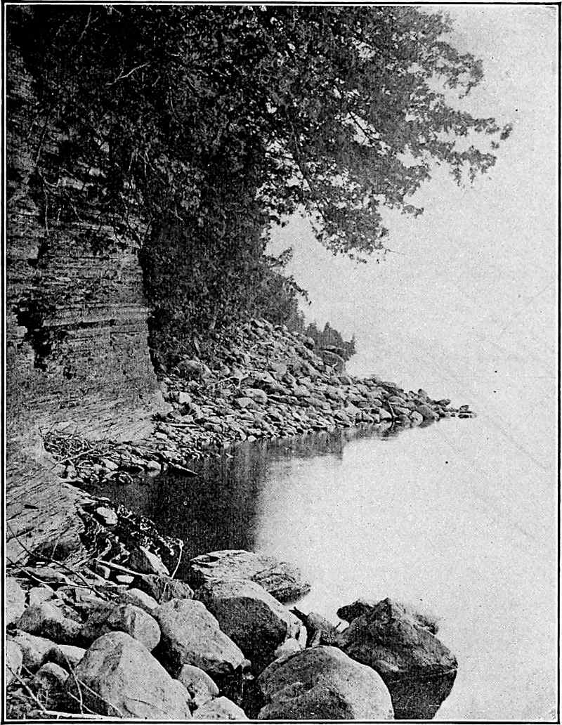
Fig.
302.—Showing blocks similar to those of
Fig.
306
, reduced and rounded by wave-action. Shore of Lake Champlain. The rock is Utica shale. (Perry.)
The direct effect of wave-erosion is restricted to a zone which is narrow both horizontally and vertically. There is no impact of breakers at levels lower than the troughs of the waves, though erosion may extend down to the limit of effective agitation (p. 341). The efficient impact of waves is limited upward by the level of the wave-crests, although the dash of the water produces feebler blows at higher levels. The rise and fall of the water during the flow and ebb of the tides gives the waves a greater vertical range than wind-waves alone would have. The vertical zone of direct wave-work is therefore limited above by the level of wave-crests, and below by the depth of wave-troughs (nearly). The indirect work of waves is limited only by the height of the shore, for as the zone of excavation is carried landward, masses higher up the slope are undermined and fall. The fallen rock temporarily protects the shore against the waves, but are themselves eventually broken up.
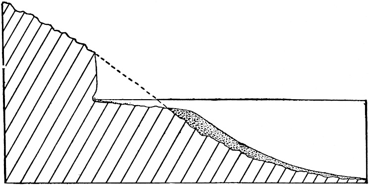
Fig.
303.—Diagram illustrating high sea-cliffs. It also shows a submerged terrace, due partly to wave-cutting (wave-cut terrace), and partly to building (wave-built terrace). (Gilbert.)
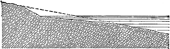
Fig.
304.—Diagram showing a low sea-cliff. (Gilbert.)
The pulsating current of the undertow (p. 341) has both an erosive and a transporting function. It carries the detritus of the shore to and fro, and dragging it over the bottom, continues downward the erosion initiated by the breakers. This downward erosion is the necessary concomitant of the shoreward progress of wave-erosion; for, if the land were merely planed away to the level of the wave-troughs, the incoming waves would break where shoal water was first reached, and become ineffective at the water margin. The rate of erosion by the undertow becomes less and less as the surface it affects is lowered. Littoral currents do little erosive work beyond that inflicted on the material which they transport.
The general result of wave-erosion is the advance of the sea on the land, the rate of advance being determined chiefly by the nature of the material attacked and the strength of the waves. Numerous as examples are of the retreat of coast-lines before the advance of the sea, it is not to be understood that the advance of the sea on the land is universal or uninterrupted. Numerous instances may be cited of the encroachment of the land on the sea. At Long Branch the advance of the sea, in spite of elaborate breakwaters, has been so rapid in recent years as to menace important buildings, while a few miles to the north and south, the land is advancing in the face of the waves. The low coast of the Middle Netherlands has retreated two miles or more in historic times,[160] but the opposite tendency is shown at other points in the same region. On the coast of England the sites of villages have disappeared by the advance of the sea within historic times,[161] but the coast of the same island affords illustrations of land advance. On the south side of Nantucket island, the sea-cliff has been known to retreat before the waves as much as six feet in a single year.[162] Almost every considerable stretch of coast affords illustrations both of the advance of the sea on the land and of land on the sea; but in the long run, the former must exceed the latter, diastrophic movements aside.
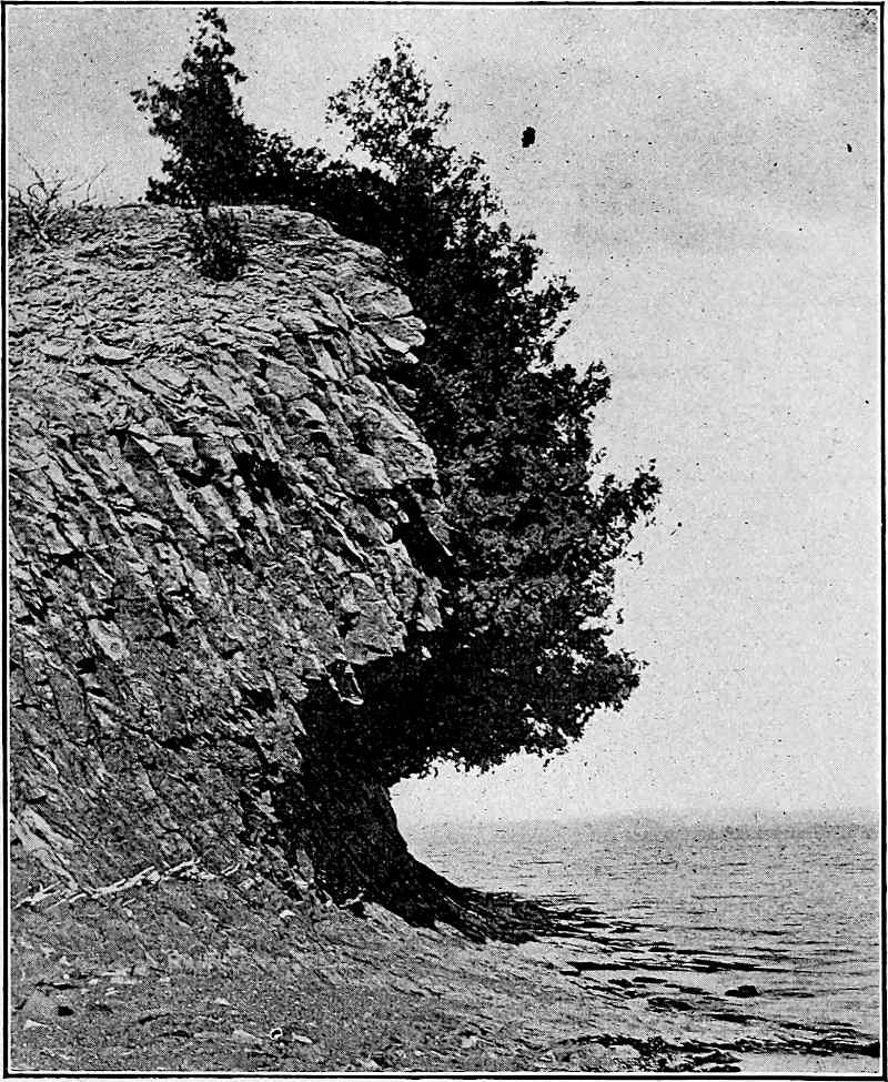
Fig.
305.—Steep cliff developed by waves. Allen Point, Grand Island, Lake Champlain. (Perry.)
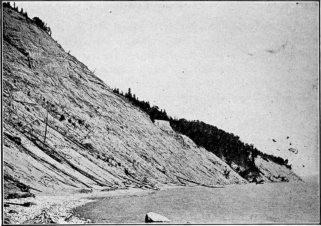
Fig.
306.—Cliff in unconsolidated material (bowlder clay), with lake-beach in foreground. South Manitou Island, Lake Michigan. (Russell,
U. S. Geol. Surv.
)
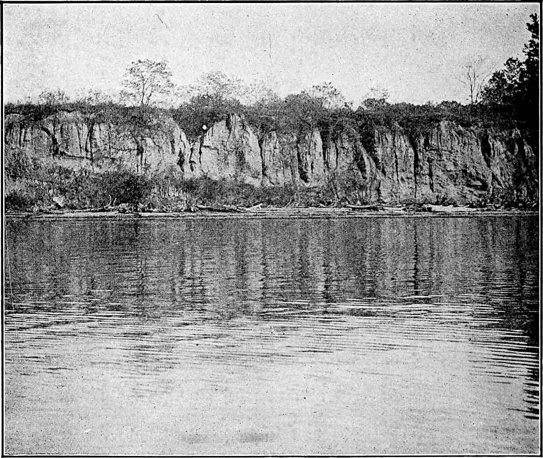
Fig.
307.—Steep cliff in unconsolidated material, the result of rapid cutting. Southeast extremity of Grove Point, Md.
Topographic Features Developed by Wave-erosion.
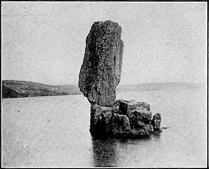
Fig.
308.—Standing Rock. A wave-erosion monument. West shore of Random Sound, south of Clarenville, N. F. (Walcott,
U. S. Geol. Surv.
)
The sea-cliff.—The action of the waves, cutting as they do along a definite horizontal zone, has been compared to the action of a horizontal saw. As the waves cut into the shore at and near the water-level, the material above, being unsupported, falls, leaving a steep face above the line of cutting. This steep face is known as the sea-cliff (Figs. 301 to 306). The same term is sometimes applied to the cliffs of lakes. The principles involved in the development of the sea-cliff are applicable to any broad stretch of water.
The height of the cliff depends on the height of the land on which the sea is advancing. Its slope may be steep or gentle (compare Figs. 303 to 306), according to the nature of the material of which it is composed and the rapidity of the cutting. Rapid cutting tends to produce steep cliffs and slow cutting gentle ones, for in the latter case weathering is more important relative to the cutting, and at sea-level (low altitudes) weathering generally tends to reduce the angle of slope. In general, the more resistant the material the steeper the slope of the cliff. Incoherent materials, such as sand and clay, are not likely to form steep cliffs; but if the cutting be very rapid, bold faces may be developed even in such materials (Fig. 307). If beds of slight resistance at sea-level underlie beds of greater resistance, the development of steep cliffs is favored. The structure of the cliff-rock also has an influence on the slope. The rock may be massive or bedded. If bedded, the beds may be horizontal, or they may dip at any angle, in any direction. The rock, whether stratified or not, may be abundantly or sparsely jointed. All these structures influence the slope and configuration of the sea-cliff (see Figs. 305 to 308).
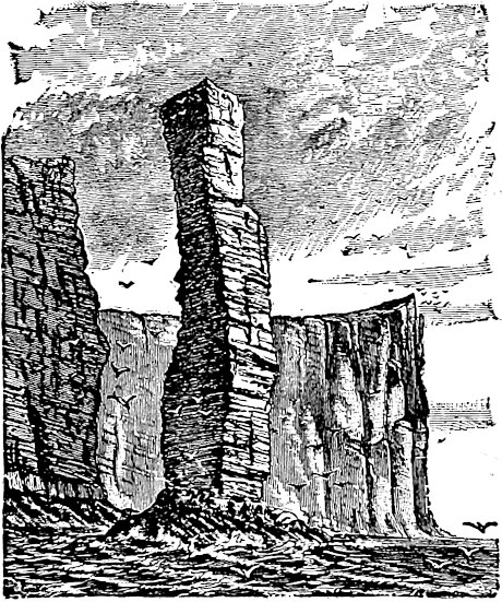
Fig.
309.—“Old Man of Hoy.” (Geikie.)
Chimney-rocks, etc.—By working in along the joints of the rock, widening them and quarrying out the intervening blocks, pillars of rock (“chimney-rocks,” “pulpit-rocks”) or even considerable islets are sometimes isolated by the waves. This is most readily accomplished where the joints converge back from the shore. A well-known example of this sort is the “Old Man of Hoy” (Fig. 309) on the coast of the Orkneys. A pulpit-rock or other island, or any jutting point of rock may be pierced, giving an arch or bridge. La Roche Percée, a steep-faced isle near Gaspé Harbor, is an example.
Sea-caves.—Waves sometimes excavate caves at the bases of cliffs. This is especially likely to occur where the rock is much jointed and where the joints are not continued to the surface in a single plane. The bottom and roof of a sea-cave usually have a pronounced inclination landward. If the cliff be low, the cave may be extended landward until its roof is pierced. Through such an opening in the top of the cliff the water of the incoming waves may be forced in the form of spray. On the New England coast such holes are sometimes known as “spouting horns.” Similar openings may be made, as already pointed out, by the compression or rarefaction of the air in the cave as the wave enters or retreats. If the roof of the cave be partially destroyed, the portion which remains may form an arch or bridge. Such a bridge occurs on Santa Cruz Island, California (Fig. 310).
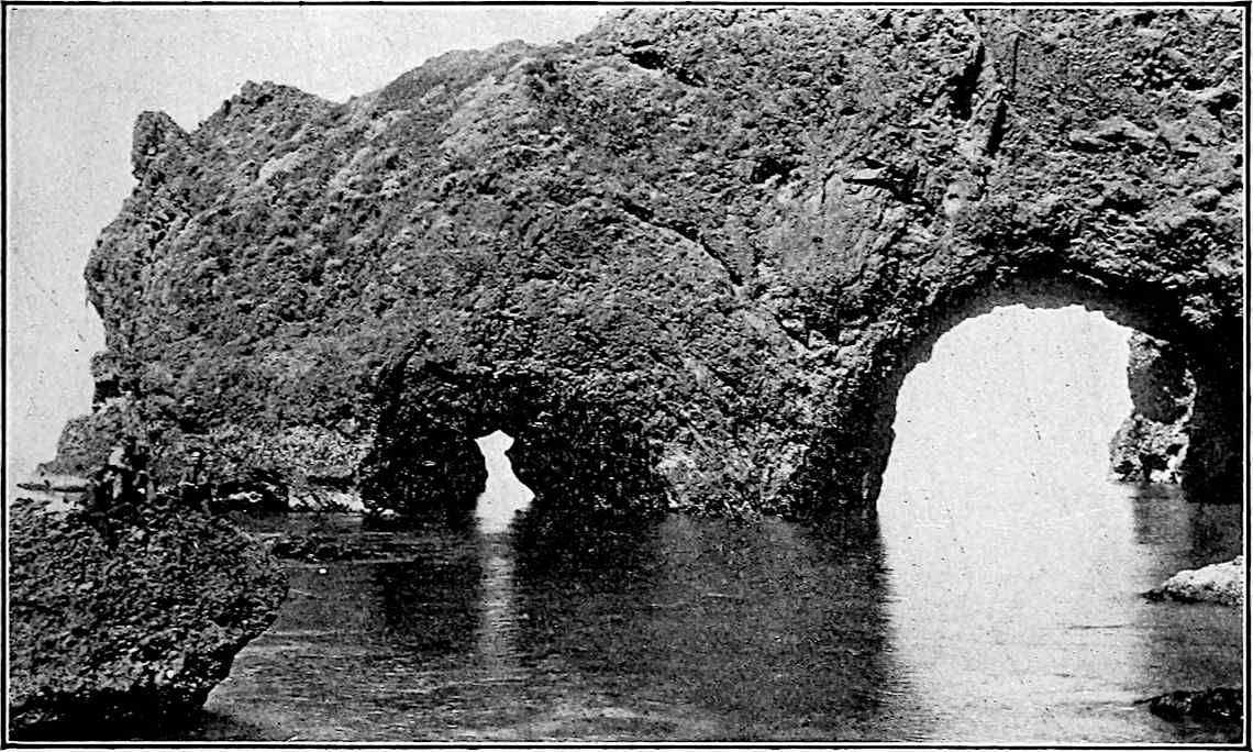
Fig.
310.—An arch developed by waves. Santa Cruz Island,
Cal.
(Law.)
The cave, the “spouting horn,” the “bridge,” the “pulpit-rock,” and other isolated islets, are all closely associated with the sea-cliff in origin.
The wave-cut terrace.—The bottom of the sea-cliff is bordered by a submerged platform over which the water is shallow. This platform, or at any rate its landward portion, represents the area over which the water has advanced as the result of wave-cutting, and is, therefore, known as the wave-cut terrace. From the method of cliff development it will be seen that the wave-cut terrace is its necessary accompaniment. Such a terrace has a gentle slope to seaward, for its outer and older edge has been degraded longer and more. Its slope is influenced by the strength of the waves, being greater where they are stronger. The outer edge of the wave-cut terrace is often marked by an abrupt descent. Fig. 303 represents the wave-cut terrace in its relation to the sea-cliff above.
Fig.
311.—An elevated cliff above Great Salt Lake. In this case the water-level has been lowered. (Gilbert,
U. S. Geol. Surv.
)
So long as wave-cut terraces are submerged, they do not appear on topographic maps of the land, though they appear on the charts of the coasts; but if a coastal tract with wave-cut terraces be elevated, or if the sea-level be drawn down, the terraces become land. Elevated sea-cliffs and wave-cut terraces are among the best evidences of change of relative level between water and land (Fig. 311).
Wave-erosion and horizontal configuration.—The structure of the rock along shore has as much to do with the horizontal configuration of the wave-shaped coast, as with its relief. In general, waves develop reëntrants in the less resistant portions of the shore, leaving the more resistant parts as headlands (San Pedro Point and Devil’s Slide, Pl. XX, Coast of California). It is to be noted that the resistance of rock to wave-erosion is not determined by its hardness alone. Every division plane, whether due to bedding, to jointing, or to irregular fracture, is a source of weakness to the rock, and rock of great hardness may be so broken as to offer relatively little resistance. Inequalities of resistance, whatever their cause, give origin to inequalities of coastal configuration where wave-erosion is in progress. Given a coast of marked regularity and equal exposure, but composed of unequally resistant material, the waves will make it irregular by cutting most where the material is least resistant. A regular coast of uniform material, but unequal exposure, will be made irregular by the greater cutting at the points of greater exposure. A coast of marked irregularity and homogeneous material will be made more regular by the cutting off of the projecting points, because they are most exposed. With a given set of conditions, waves tend to develop a certain sort of shore-line which, so far as its horizontal form is concerned, is relatively stable. Such a shore-line may be said to be mature[163] so far as wave-erosion is concerned. Since coastal lands are, in general, both heterogeneous and unequally exposed, a mature coast-line is somewhat irregular. Its maturity is attained when the lesser exposure in the reëntrants developed in the less resistant parts, balances the superior exposure of the projections of the more resistant portions.
Since the conditions of erosion along coasts are constantly, even if slowly, changing, maturity is constantly being approached, but rarely reached. Other forces and processes, such as those of aggradation, vulcanism, and diastrophism, are in operation along coasts, and their results are sometimes antagonistic to those of the waves. The horizontal configuration of coasts is, therefore, the result of many coöperating forces, of which waves are but one. It is, nevertheless, important to note the goal to which the waves are working, even though they are continually defeated in their attempt to reach it. Their immediate goal is an equilibrium of erosion-rate and maturity of configuration; their final goal is the destruction of the land and the deposition of its substance in the sea, that is, in a position nearer the center of gravity of the earth.
Transportation by Waves.
The material eroded from the shore by the waves in the shaping of the cliff and terrace is carried away by the joint action of the waves, undertow, and shore-currents.
The in-coming wave begins to shift material where it begins to drag bottom, that is, a little outside the line of breakers. From the line where transportation begins, to the line of breakers, bottom detritus is shifted shoreward by the waves, while the undertow tends to carry it back again. Between the breakers and the shore there is also a tendency for the on-shore movement to carry débris to the water’s edge, and for the ebbing wave to carry it back again. The result of these opposed tendencies is to keep sediment in transit between the shore and the line of breakers. If the in-coming waves have a direction normal to the shore, the advance and recoil of the water move particles toward and from the shore, but effect no transfer along the shore; but the results which waves normal to the shore would achieve are always modified by other waves and by littoral currents.
If the in-coming wave is oblique to the shore, it shifts material in its own direction. The transfer by undertow, taken alone, would be sensibly normal to the shore, but the effect of the oblique waves is to slightly modify this direction. There is thus a slow transportation along shore, even in the absence of steady currents. A great amount of transportation would be effected in this way, though it would be carried on at a slow rate. Oblique waves also tend to develop a definite shore-current (p. 342) which affects both the amount and direction of the transportation. Any particle in suspension, or in motion on the bottom as the result of the wave or undertow, is shifted along shore by the littoral current, which affects the same water (Fig. 300). By the coöperation of wave- and shore-current, more and heavier material can be moved than by either alone, and the direction of movement is more nearly parallel to the shore than that of the wave. Similarly, by the coöperation of undertow and shore-current, more and heavier material can be moved than by either alone. The direction of movement is readily inferred from Fig. 300. The direction in which débris is shifted by wave- and shore-current is modified by the undertow, and the direction which would result from undertow and current is modified by the wave. It is often the waves of storms, rather than those of the prevailing winds, which determine the direction of greatest shore transportation.
The waves, the undertow, and the littoral currents work together in assorting the detritus of the shore. The coarsest parts may be beyond the power of all but the strongest waves. They accumulate where agitation is great. Less coarse parts are shifted farther from the site of greatest agitation, but no materials which are classed as coarse are carried beyond the depth of sensible movement. The coarse material which covers the bottom where the agitation of the water at the bottom is effective, constitutes shore drift.
Shore drift is not all derived from the shore by the cutting of the waves. A part of it is brought to the sea by streams and mingled with that eroded from the cliffs. The material which is fine enough to be held in suspension is measurably independent of depth. This is shown during storms when the water becomes turbid far beyond the line of breakers, and clears only after the waves have died away.
This sorting of shore drift, effected while it is in transportation, is often very perfect. The conditions favoring assortment are (1) vigorous wave-action, (2) prolonged transportation, and (3) a moderate volume of sediment.[164] The effect of these several conditions will be readily understood.
Extensive transportation of shore drift of a given degree of coarseness is favored by (1) strong waves and undertow, (2) continuous currents, and (3) shallow water, deepening but gradually off shore.
Deposition by Waves, Undertow, and Shore-currents.[165]
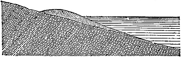
Fig.
312.—Cross-section of the beach. (Gilbert.)
The beach.—The zone occupied by the shore drift in transit is the beach. The lower margin is beneath the water, a little beyond the line where the great storm-waves break. Its upper margin is at the level reached by storm-waves, and is usually a few feet above the level of still water. To the beach, material is brought from seaward by the in-coming waves, and from it detritus is carried out by the undertow. The cross-section of a beach is shown in Fig. 312. In horizontal position the beach follows the general boundary between water and land, though it does not conform to its minor irregularities (Fig. 313). The beach or barrier ridge often causes the deflection of the lower courses of streams descending to it (Pl. XXI).
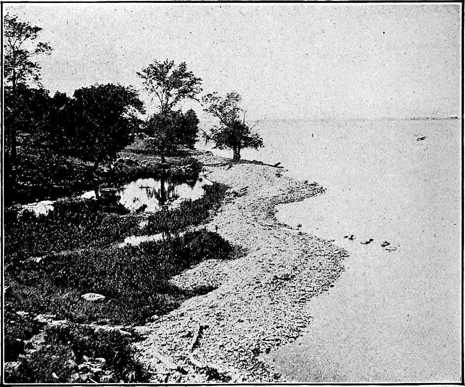
Fig.
313.—A lake-beach (barrier); Griffin’s Bay, Lake Ontario.
PLATE XXI.
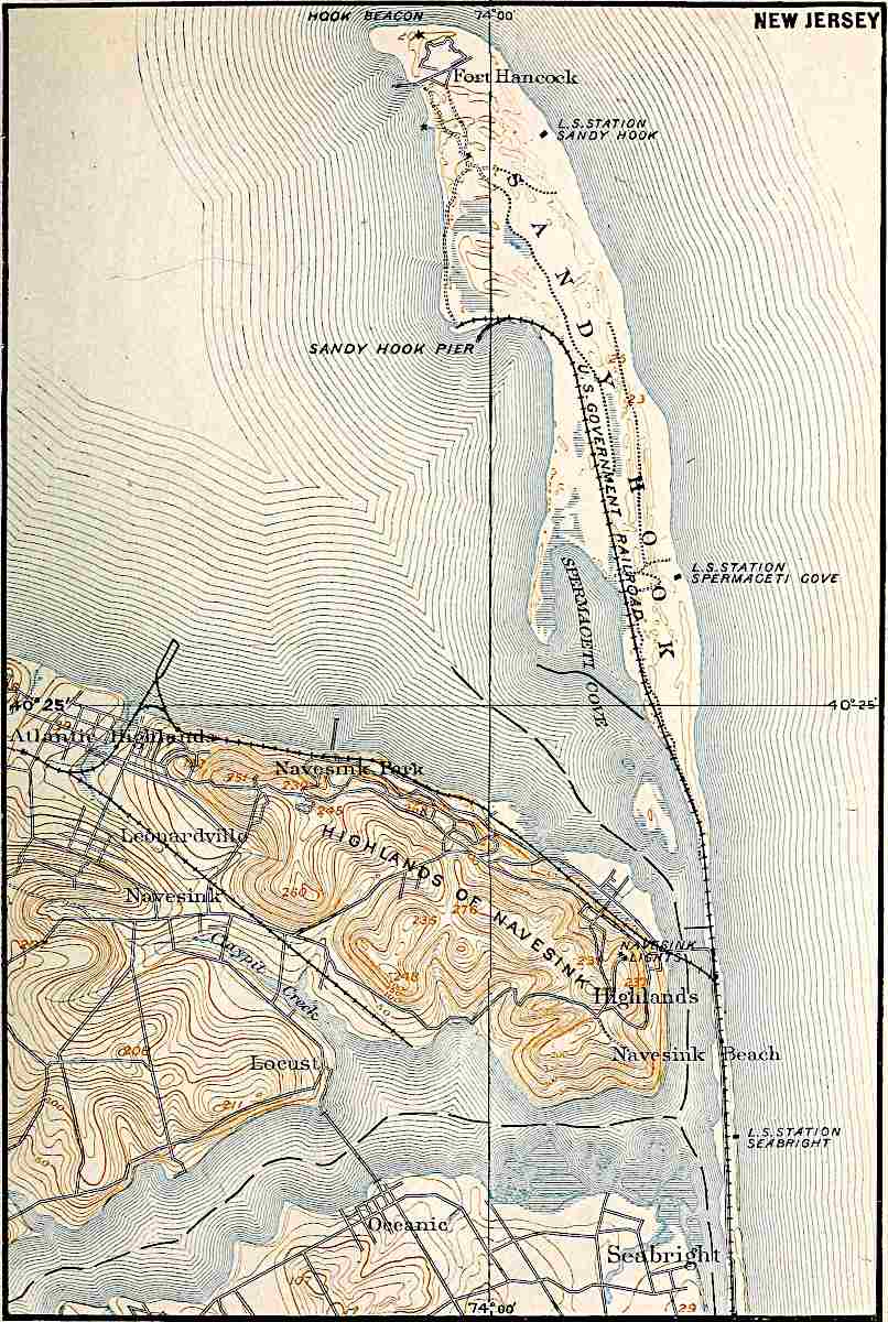
U. S. Geol. Surv.
Scale, 1 mile per inch.
NEW JERSEY.
PLATE XXII.
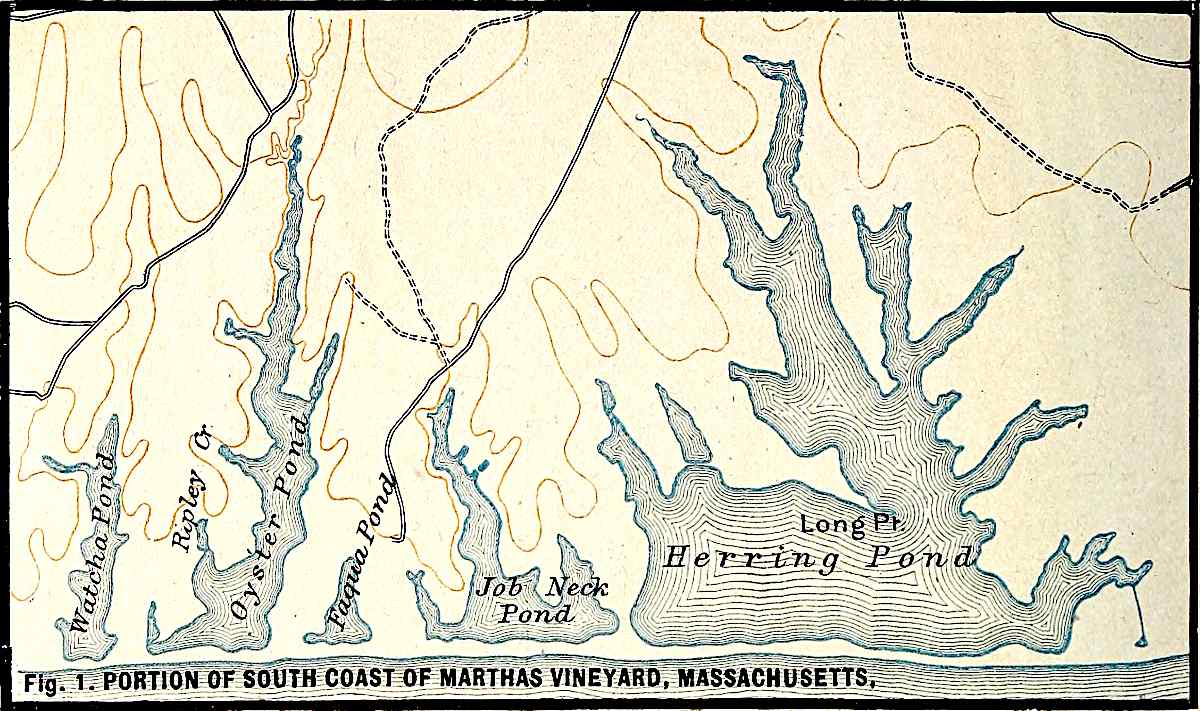
U. S. Geol. Surv.
Scale, 1 mile per inch.
Fig.
1. PORTION OF SOUTH COAST OF MARTHAS VINEYARD, MASSACHUSETTS.
U. S. Geol. Surv.
Scale, 1 mile per inch.
Fig.
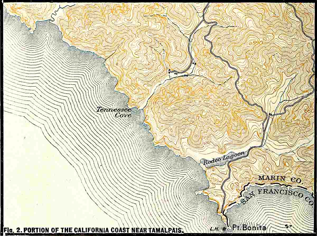
2. PORTION OF THE CALIFORNIA COAST NEAR TAMALPAIS.

Fig.
314.—Section of a barrier. (Gilbert.)
The barrier.—When the agitation of the water along shore becomes insufficient to carry the material, it is dropped. In its deposition it assumes various forms. Where the bottom of the lake or sea near shore has a very gentle inclination, the in-coming waves break some distance from the shore-line, and it is here that the most violent agitation occurs when the waves are strong. To this line of breakers, material is shifted from both directions: from shore by undertow, and from seaward by the waves. Accumulating here, it builds up a low ridge. This is a barrier (Fig. 314). If it is built up above the surface of the water by storm-waves, it may shut in a lagoon behind it, and this may ultimately be filled by sediment washed down from the land. At one stage in the filling, the lagoon becomes a marsh.[166] In the part which the barrier plays in the history of a coast, it is identical with the beach.
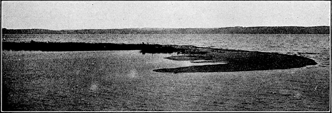
Fig.
315.—A recurved spit. Dutch Point, Grand Traverse Bay, Lake Michigan.
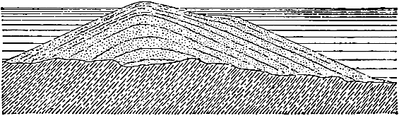
Fig.
316.—Cross-section of a bar. (Gilbert.)
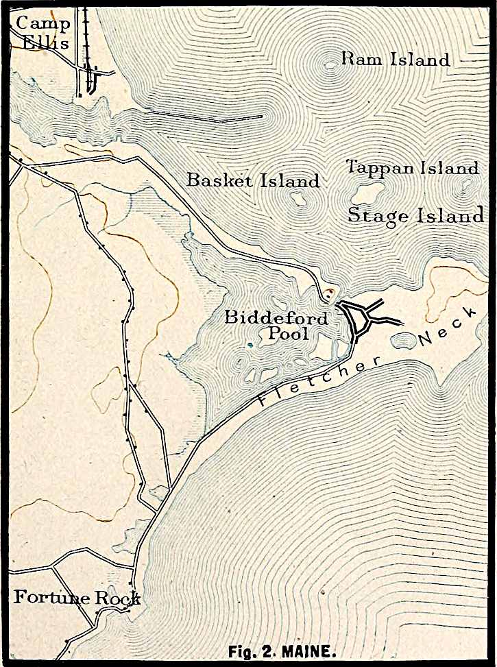
The spit, the bar, and the loop.—The disposition of shore-deposits depends largely on the currents at and near shore. If the coast-line is deeply indented, the littoral current usually fails to follow the reëntrants. In holding its course across the mouth of a small bay, a shore-current usually passes into deeper water. Here its velocity is checked because its motion is communicated to the water beneath it, and a larger amount of water being involved in the motion, the motion of each part is diminished. If sediment was being moved along its bottom before the current was checked, some part of it is dropped when and where the current is slackened. It follows that deposition commonly takes place beneath a littoral current as it crosses the mouth of a bay. The belt of deposition is often narrow, and the result is the construction of a ridge beneath the water in the direction of the current. The current would never build the embankment up to the water-level, but when its surface approaches the level of effective agitation, the waves may begin to work on it, as on a barrier, and may build it up to, and even above, the surface of the water. So long as the end of such an embankment is free, it is a spit (Fig. 315 and Pl. XXI). If the spit be lengthened until it crosses, or nearly crosses, the bay, shutting it off from the open water, it becomes a bar. Bars have shut in lakes (ponds) on the coast of Martha’s Vineyard, Mass. (Fig. 1, Pl. XXII), and lakes and lagoons at numerous points both on the Atlantic and the Pacific coasts (Fig. 2, Pl. XXII, Rodeo lagoon). The same phenomena are to be seen along many lake shores. Bars sometimes tie islands to the mainland (Pl. XXIII, Fig. 1, Nahant, Mass.; Fig. 2, near Biddeford, Me.). The structure of a bar as seen in cross-section is shown in Fig. 316.
The construction of a spit has been aptly compared to the construction of a railway embankment across a depression. The material is first carried out from the bordering upland (shallow water) and dumped where the slope to the depression (deep water) begins. The embankment thus begun is extended by the carrying out of new material, which is left at the end of the dump already made.
If the bay across which the bar is built receives abundant drainage from the land, the outflow from the bay may be sufficient to prevent the completion of the bar (Fig. 2, Pl. XXII), for when the growth of the spit has sufficiently narrowed the outlet of the bay, the sediment brought to the end of the spit by the littoral current will be swept out beyond the spit by the current setting out from the bay.
The completion of a bar may be interfered with by tidal currents, even without land-drainage. Currents generated by the tides may sweep in or out of the bay with increased force as the entrance is narrowed, carrying in or out the sediment which the littoral current would have left at the end of the spit. The scour of the tides often insures deep entrances (inlets) to bays, and maintains definite channels or “thorofares” in the lagoon marshes behind barriers and spits. The sediment brought down from the land, as well as that washed in by tidal currents and waves, tends to fill up the lagoon behind a barrier, a spit, or a bar, converting it into land (Fig. 317).
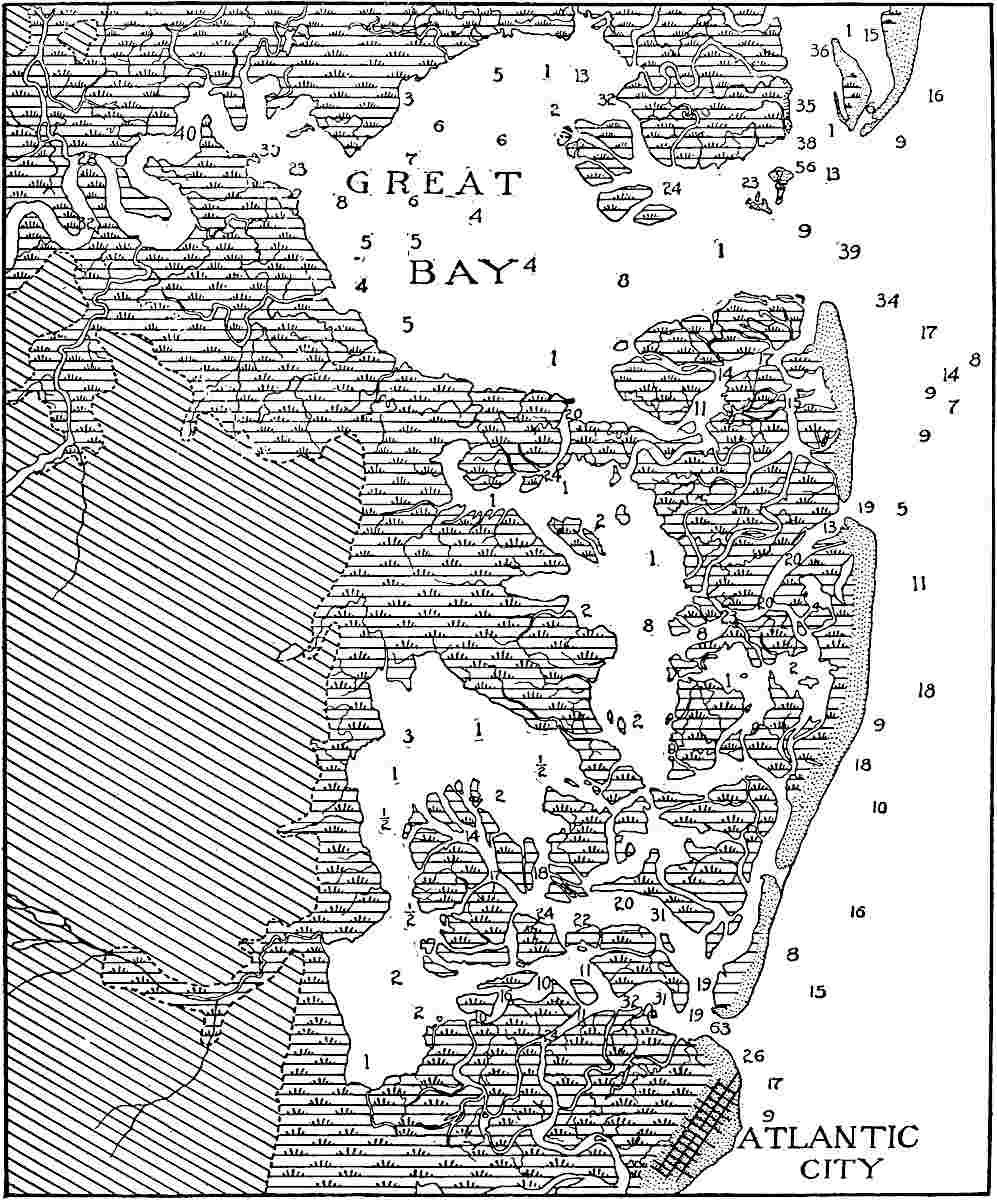
Fig.
317.—Sketch of a portion of the New Jersey coast. The dotted belt next the sea is the barrier, modified by the wind. The area marked by the diagonal lines is the mainland. In the marshy area between, there are numerous channels or “thorofares” kept open by the currents. The figures show the depths of water in feet. Scale about ⅜ inch = 1 mile.
Since spits and bars are built only where there is shore-drift in transit, they are always built out from a beach or barrier. The distal end of the bar may also join a beach or barrier. Traced back to its source, the beach from which a spit leads out is often found to terminate in the cliff from which the material of the beach and the spit were derived (Pl. XX and Fig. 2, Pl. XXII). In such cases the sediment of the beach has been shifted but a short distance; but in other cases it has traveled far.
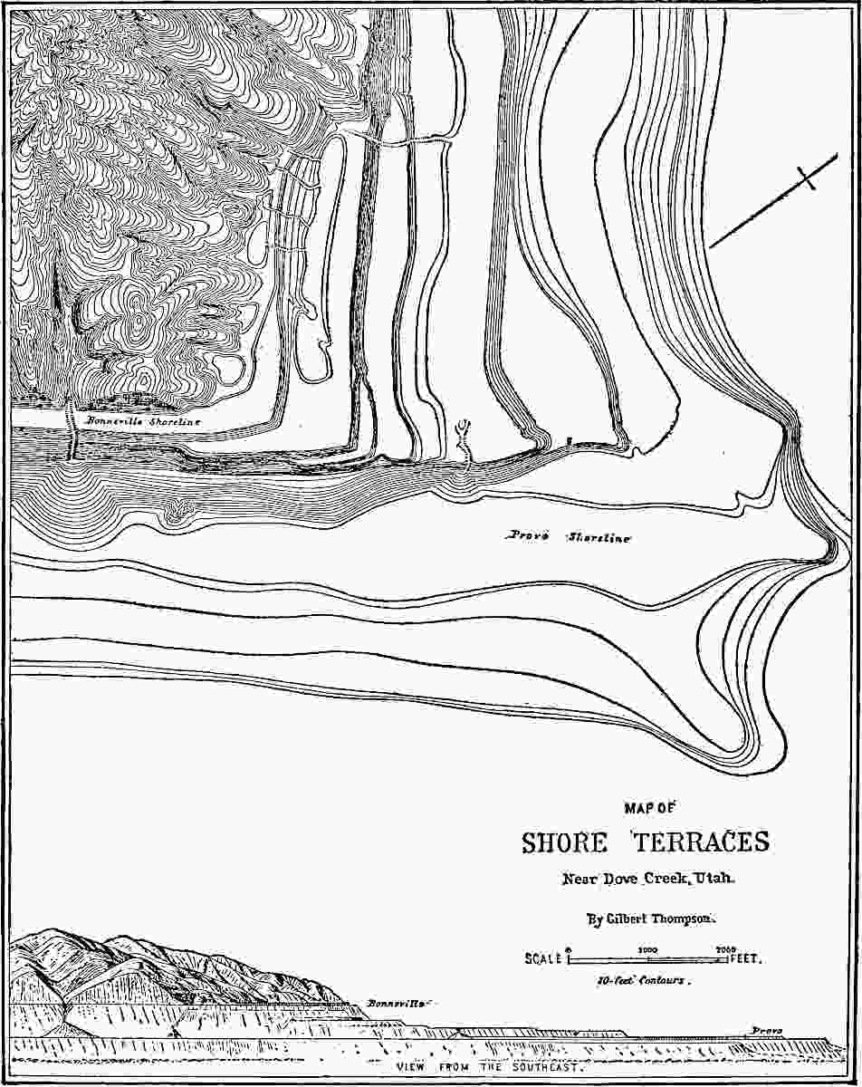
Fig.
318.—Map of shore-terraces, largely wave-built. Lake Bonneville. (Gilbert.)
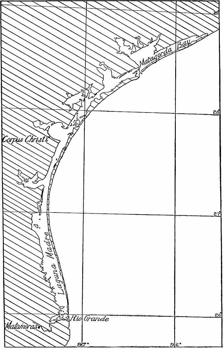
Fig.
319.—A portion of the Texas coast showing the tendency of shore-deposition to simplify the coast-line. The deposits (the narrow necks of land parallel to the coast) shut in the bays. (From chart of C. and G. Surv.)
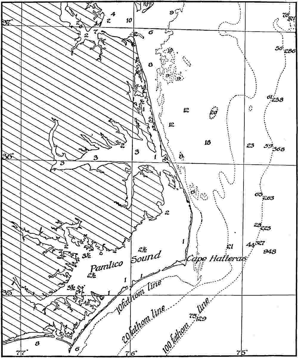
Fig.
320.—Map showing that in the early stages of the simplification of a shore-line the irregularities are increased. The numbers indicate the depth of water in fathoms. (From chart of C. and G. Surv.)
The spit is usually either straight or in conformity with the general course of the shore-current, but since the littoral current itself is subject to alteration as the result of shifting winds, the spit may depart from straightness. Winds which simply reverse the direction of the littoral current retard its construction, but may not otherwise affect it; but if a strong current be made to flow past the end of a spit, it may cut away its extremity and rebuild the materials into a smaller spit, joining the main one at an angle. This gives rise to a hook (Fig. 315). Successive storms may develop successive hooks along the side of a growing spit. The end of a hook may be so extended as to join the mainland, when it becomes a loop.
Wave-built terraces.—Under the influence of off-shore currents, littoral currents may be drawn from the coast-line. If such a current continues as a well-defined surface-current, it builds a spit, but if it spreads, it tends to build a terrace. The accumulation then is not at the end of a beach, as in the case of a spit, but on its side, and the result of the deposition is to carry the beach seaward. The undertow abets the process. The widened beach is a wave-built terrace. The wave-built terrace often borders the wave-cut terrace along its seaward margin (Figs. 303 and 318). With the help of waves, the surface of the terrace may be built up into land by the expansion of the crest of the beach. Terrace-cutting and terrace-building are both involved in the development of the continental shelves.
Beach ridges, spits, bars, etc., like sea-cliffs and wave-cut terraces, are often preserved after the relative level of sea and land has changed. If the shore has risen, relatively or absolutely, these features are relied on as evidences of the change. If shore features be submerged instead of elevated, they furnish less accessible, though not less real, evidence of the change of level. Similar features about lakes have a like significance, but in this case it is often demonstrable that it is the water rather than the land which has changed its level.
Effect of Shore-deposition on Coastal Configuration.
The tendency of shore-deposition is to cut off bays and to straighten and simplify the shore-lines. This is abundantly illustrated along the Atlantic and Gulf coasts of the United States (see Fig. 319 and Pl. XXII). It is to be noted, however, that in the simplification of the shore-line through deposition, the initial stages often result in great irregularity (Fig. 320 and Pl. XXIII). In some cases, the irregularities are not temporary. Thus deltas (p. 198), though not wholly the work of sea- (or lake-) water, often constitute irregularities of a more or less permanent nature. This is the case where they project beyond the general trend of the coast-line. Where, on the other hand, they are built at the heads of bays, they tend to simplify the coast-line by obliterating the indentation. The delta at the head of the Gulf of California is an example. So too is the delta of the Mississippi, the real head of which is far above the present debouchure of the stream. The form of the delta in ground-plan depends on the horizontal configuration of the coast where it is developed, on the strength of the waves and shore-currents, and on their relation to the amount of detritus contributed by the stream concerned. Good illustrations are furnished by the Gulf of Mexico where the deltas of the Mississippi and Rio Grande are in contrast.
So far as concerns the vertical configuration of coasts, erosion and deposition are in contrast, for while the former tends to develop steep, irregular, and often high slopes (p. 349) from the land to the sea, the latter tends to develop gentle, regular, and low ones. A partial exception to the latter part of this general statement comes about through the building of dunes, the material for which is furnished by the waves.
SUMMARY OF COASTAL IRREGULARITIES.
The horizontal irregularities of coasts are both large and small. Some of them, like Florida, Sandy Hook, etc., consist primarily of projections of land into the sea; others, like Chesapeake Bay, the Gulf of Mexico, and Puget Sound, are projections of the sea into the land; while still others, like the Gulf of California and its associated peninsula, cannot readily be put in either of the foregoing classes. Some of the irregularities of the land border, such as Yucatan, are more or less nearly normal to the general trend of the coast which they affect, while others, such as the “beaches” along the Atlantic and Gulf coasts of the United States (Figs. 319 and 320), are more or less nearly parallel with it. Some of the irregularities, especially some of the small ones, are more or less angular in their outline (Pl. XX and parts of Fig. 2, Pl. XXII), while others are bounded by curves instead.
In many cases more than one factor has been involved in the development of irregularities. In the case of great irregularities, diastrophism has generally been the dominant factor. The Gulf of Mexico and the Mediterranean Sea perhaps represent differential subsidence, while Florida and the Iberian peninsula represent differential uplift (relative, though perhaps not absolute). The narrow bays which indent many coasts generally represent the subsidence of a region previously affected by valleys (Fig. 297). Many of them, such as Narragansett, Delaware, and Chesapeake Bays, are primarily the drowned ends of river valleys, while others, such as Puget Sound,[167] are primarily structural valleys (synclines). Many of the long and narrow bays or fiords common in the high latitudes of North America and Europe (Fig. 266, p. 293) appear to be the drowned ends of valleys previously deepened by glaciers. The drowned ends of river canyons, and the submerged parts of valleys excavated (not sunk) beneath the sea by glaciers, would also be fiords.
PLATE XXIII.
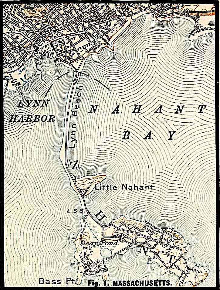
U. S. Geol. Surv.
Scale, 1+ mile per inch.
Fig.
1. MASSACHUSETTS.
U. S. Geol. Surv.
Scale, 1+ mile per inch.
Fig.
2. MAINE.
PLATE XXIV.
U. S. Geol. Surv.
Scale, 1+ mile per inch.
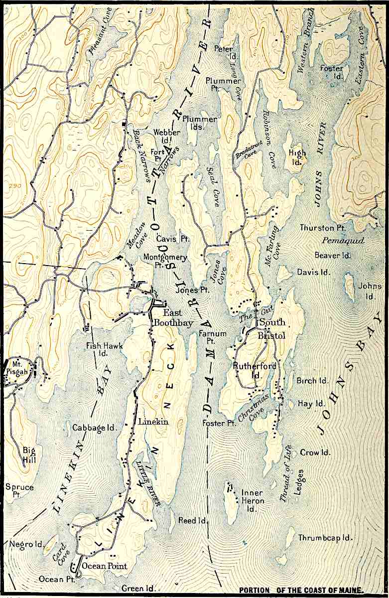
PORTION OF THE COAST OF MAINE.
The processes which develop coastal indentations, together with the antecedent subaërial and the subsequent wave gradation, account for most of the islands which affect indented coasts. Some of them are high and some low for reasons which will be readily understood. The long narrow belts of land constituting irregularities parallel to the general trend of the coast (Figs. 319 and 320) are usually the result of deposition in shallow water. They are usually sand or coral reefs, built up above water-level by waves. The deposits at the debouchures of streams give rise to projecting deltas. Most small irregularities of angular form, especially if high (Pl. XX), indicate wave-erosion, and their details of form are determined by the structure of the rock along shore, while most irregularities of curved outline involve something of shore-deposition, if not due wholly to it. Glaciation, or glaciation and subsidence, may also give rise to peninsulas, capes, and islands of curved outlines (Pl. XXIV, coast of Maine). Curving outlines may, however, be developed by erosion alone in weak rock structures. This is illustrated by the weak rock structures (clay, sand, etc.) of most of the Atlantic coastal plain. Thus inspection of the horizontal configuration of coasts will often indicate the processes which have been dominant there in recent times. On the other hand, the interpretations of many coastal irregularities, such as Hudson Bay, Puget Sound, the Gulf of California, the Baltic Sea, etc., are not to be read from the map. In such cases, diastrophism and gradation have usually coöperated, but the relative importance of the two processes can only be determined by detailed study in the field. When it is remembered that the tendency of shore-erosion is to reduce great irregularities of horizontal configuration, though not to obliterate small ones if the coast be heterogeneous in composition (p. 353), and that the tendency of shore-deposition is also to regularity, it is clear that the great irregularities of coast-lines are due neither to shore-erosion nor to shore-deposition, though minor ones may be due to either.
THE WORK OF OCEAN-CURRENTS.
As agents of erosion, ocean-currents are not, in general, of great importance. Currents which reach the bottom are comparable, in their effects, to rivers of the same velocity and volume; but most ocean-currents do not touch bottom, and, therefore, do not erode it. Where the current agitates the bottom sensibly, as it often does in shallow water, the bottom is abraded, and in the lee of such places it is doubtless aggraded. Since ocean-currents do not, for the most part, flow in shallow water, their erosive work is, on the whole, relatively slight; but where they are forced through narrow and shallow passageways, their abrasive work may be considerable. Thus the Gulf Stream, where it issues from the Gulf, has a velocity of four or five miles per hour, and its shallow and narrow channel is current-swept.
A rough test of the abrasive work of an ocean-current is found in the nature of the bottom beneath it. If this be hard, it indicates that the loose sediment on the floor of the ocean has been swept away, while the presence of fine detritus indicates that the current is not wearing. Thus the abrasive power of the Gulf Stream is known to continue somewhat beyond its narrow channel, for on the Blake plateau (between the Bahamas and Cape Hatteras), where the water is 600 fathoms and less in depth, “the bottom of the Gulf Stream ... is swept clean of lime and ooze and is nearly barren of animal life.”[168] Other illustrations of the erosive power of currents have been noted near Gibraltar in water 500 fathoms deep, and between the Canary Islands at depths of 1000 fathoms.[169] In spite of these examples, and of many others which probably exist in similar situations, it yet remains true that ocean-currents are on the whole but feeble agents of erosion.
As agents of transportation, ocean-currents are scarcely more important than as agents of corrasion, for they transport only what they erode, if the life which inhabits them be left out of consideration. This phase of their work has probably been exaggerated through a confusion of transporting energy and actual transportation. Ocean-currents which do not touch bottom roll no sediment and carry only what may be held in suspension. A river’s power of transporting sediment in suspension is due largely to the cross-currents occasioned by the unevenness of its resistant bottom (p. 117). If a particle of mud in suspension in a river drops to the bottom, as it frequently does, it may be picked up again and carried forward. If, on the other hand, a particle in suspension in an ocean-current once escapes the moving water by settling through it, the current which does not drag bottom has no chance to pick it up again. Very fine sediment may be carried by an ocean-current far beyond the point where it was acquired, but currents which do not touch bottom are rarely strong enough to hold any but the finest material for any considerable length of time. As transporters of sediment, therefore, ocean-currents are at a great disadvantage as compared with rivers.
How readily particles of extreme fineness may be kept in suspension, and how little agitation is necessary to keep them from sinking, is shown by the experiments of Sorby, who showed that while a sand grain ¹⁄₁₀₀ of an inch in diameter will settle one foot per second in still water, fine particles of clay require days to sink through the same distance. The Challenger found fine sediment derived from the land 400 miles from the coast of Africa, and that not opposite the debouchure of any large river. Sediment settles more readily in salt water than in fresh, despite the fact that the former is heavier. This is presumably because the salt diminishes the cohesion of the water.
Deposition by ocean-currents is limited by their transportation. Only where they erode their bottoms do they gather coarse materials, and only in the lee of such places are their deposits coarse. Since the material which they carry is generally fine, it is widely distributed before deposition.
Ocean-currents have little influence on the configuration of coast-lines.
DEPOSITS ON THE OCEAN-BED.
Something has already been said concerning the sediments which accumulate in the shallow waters along shores; but the area of marine sedimentation is as extensive as the ocean itself, and the deposits must now be reviewed from another point of view.
Oceanic deposits may be conveniently divided into two chief groups, dependent on the depth of the water in which they are made.[170] These groups are (1) shallow-water deposits, made in water less than some such depth as 100 fathoms, and (2) deep-sea deposits, laid down in water of greater depth. The selection of the 100-fathom line as the dividing depth is less arbitrary than it seems, for passing outward from the shore, it is at about this depth that the bottom ceases to be commonly disturbed by the action of currents and waves; that sunlight and vegetable life cease to be important at the bottom; and that the coarser sediments which predominate along shore give place, as a rule, to muds and oozes. Furthermore, the 100-fathom line (or some line very near it) is an important one in the physical relief of the globe, for it appears to mark, approximately, the junction of continental plateaus and ocean-basins. Only because the latter are a little over-full does the water run over their rims, covering about 10,000,000 square miles of the borders of the continents, converting them from land into epicontinental seas.
Aside from the deposits made by organisms, shallow-water deposits are divisible into two groups—(a) those immediately along the shore, the littoral deposits, and (b) those made between the littoral zone and the 100-fathom line. Both are terrigenous. The deep-sea deposits likewise are divisible into two groups, (a) terrigenous deposits formed close to land, and made up chiefly of materials derived immediately from the disintegration of land formations; and (b) the pelagic deposits, made up chiefly of the remains of pelagic organisms and the ultimate products arising from the decomposition of rocks and minerals. The former predominate in the less deep waters relatively near shore; the latter in the deeper water far from land. The shallow- and deep-water deposits grade into each other in a belt along the 100-fathom line.
Shallow-water Deposits.
Littoral deposits.—The littoral zone is the zone between high- and low-water marks. It is the zone in which bowlders, gravels, sands, and all coarser materials accumulate, though muds are occasionally met with in sheltered estuaries. Generally speaking, the nature of these deposits is determined by the character of the adjoining lands and the nature of the local organisms. “The heavier materials brought by rivers from high terrestrial regions, or thrown up by the tides and waves of the sea, are here arranged with great diversity of stratification through the alternate play of the winds and waves. Twice in the twenty-four hours the littoral zone is covered by water and exposed to the direct rays of the sun or the cooling effects of the night. There is a great range of temperature; mechanical agencies produce their maximum effects,”[171] and physical conditions in general are most varied. Still greater diversity is introduced by the fact that the zone is inhabited by both marine and terrestrial organisms, while the evaporation of the sea-water which flows over tidal marshes and lagoons leads to the formation of saline deposits. If the length of the coast-lines of the world be taken at 125,000 miles (about 200,000 kilometers), and the average width of this zone at half a mile, these deposits are now forming over an area of 62,500 square miles (about 160,000 square kilometers) of the earth’s surface.
Non-littoral, mechanical deposits in shallow water.—These deposits are laid down in the zone of the ocean between low-water mark and the 100-fathom line. They cover about 10,000,000 square miles.[172] Their composition is much the same as that of the littoral deposits, with which they are continuous, though on the whole they are finer. At their lower limit they pass insensibly into the fine deposits of the deep sea. Coarse material, such as gravel and sand, prevails, though in special situations, such as depressions and inclosed basins, muddy deposits are found. While some of the deposits are wholly composed of inorganic débris, organic remains are freely mingled with others. The mechanical effects of tides, currents, and waves are everywhere present, but become less and less well marked as the 100-fathom line is approached. The forms of vegetable and animal life are numerous, though the former decrease as depths which exclude the sunlight are approached.
Both littoral deposits and deposits in shallow water outside the littoral zone have already been referred to in connection with the work of waves and currents (pp. 355–66). A few additional points only need here be added.
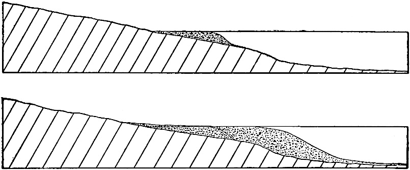
Figs.
321 and 322.—Diagrams showing how shallow-water deposits may attain considerable depth by the shifting of the zone of deposition seaward.

Fig.
323.—Diagram showing the interwedging of gravel-, sand-, and mud-beds.
In general the coarser sediments are lodged near shore and those farther from the land become progressively finer. Even the coarser part of the material carried in suspension by the undertow is partly left in the shallow water. On the other hand, waves of exceptional strength may carry coarse material into water of some depth. Thus coarse shingle (gravel) and even bowlders have been found at depths of 10 fathoms.[173] Coarse deposits may extend far out from land if the waves are strong, and especially if the water is shallow, and since the zone of shallow water may be extended seaward by the aggradation of the bottom, shallow-water deposits may cover extensive areas. They may become deep at the same time, for as the outer border of the shallow-water zone is shifted seaward by aggradation, the vertical space to be filled becomes greater (compare Figs. 321 and 322). Again, if the coast be sinking, new deposits of coarse material may be made on older ones. In this way also great thicknesses of sediment may be accumulated, all parts of which were deposited in shallow water. The great thickness of some of the conglomerate beds of the past shows how far this process may go.
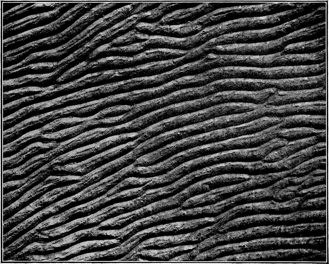
Fig.
324.—Ripple-marks.
Fig.
325.—Rill-marks resembling impressions of seaweeds. Beach at Noyes Point, R. I. (Walcott,
U. S. Geol. Surv.
)
Fig.
326.—Rill-marks. Same locality as 325. (Walcott.)
As a rule, no definite line marks the seaward terminus of the coarse detritus, since coarse material is carried farther out when the waves run high (and the undertow is strong) than when they are feeble. In calm weather, therefore, fine sediment may be deposited where coarse had been laid down in the preceding storm, only to be covered in turn by other deposits of a different character. Thus gravel grades off into sand, with more or less overlapping or interwedging, and sand grades off into silt in the same way. This is diagrammatically illustrated by Fig. 323.
Characteristics of shallow-water deposits.—Clastic sediments laid down in shallow water have several distinctive characteristics. While they are, in the aggregate, coarse, they are characterized by frequent variations in coarseness. The surfaces of successive beds are likely to be ripple- and rill-marked (Figs. 324, 325, 326), and cross-bedding (Fig. 327) is of common occurrence. Clayey sediments accumulated between high and low water are often sun-cracked (Fig. 328), and the tracks of land animals are sometimes preserved on their surfaces. Shallow-water deposits often contain fossils of organisms which live in waters of slight depth. These characteristics are sufficient to differentiate sedimentary formations made in shallow water from those made in deep water, even after they have been converted into solid rock and after the rock has emerged from the sea. Many of these characteristics are, however, shared by deposits made by streams on the land. Subaërial and lacustrine sediments are usually distinguishable from those made in the sea by their fossils, and sometimes by their distribution.

Fig.
327.—Cross-bedding. (Gilbert.)
Fig.
328.—Sun-cracks. These cracks were on the mud-flats of the Missouri a few miles above Kansas City, but the sun-cracks on shore-deposits are not essentially different. (Calvin.)
Topography of shallow-water deposits.—The shallow-water deposits have, on the whole, a rather plane surface, though there are some notable departures from flatness. The steep slopes of the delta fronts and of wave-built terraces have already been spoken of. Barriers often shut in depressions, and the disposition of the material deposited is sometimes uneven, owing to shore and tidal currents. The result is that the surface of the shallow-water deposits is often affected by low elevations and by shallow depressions. The elevations and depressions may be elongate, circular, or irregular in form. These general facts are shown in Figs. 319, 320, and 329. This topography is sometimes preserved on newly emerged lands, as at various points on the Coastal Plain of the United States.
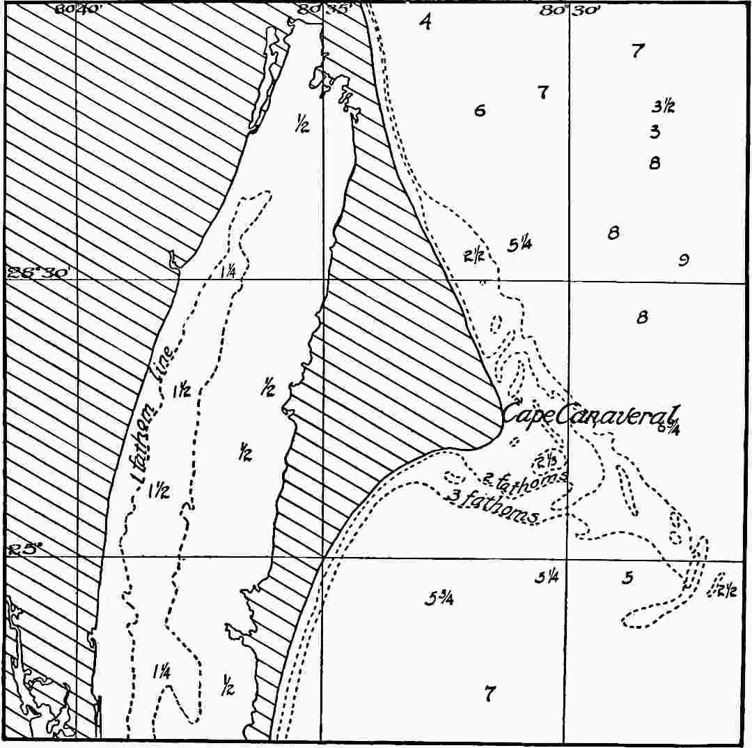
Fig.
329.—Irregularities of topography of shallow-water deposits. The depths of the water are shown in fathoms. (Chart of C. and G. Surv.)
Chemical and organic deposits.—There is no sharp line of distinction between the deposits usually classed as chemical and those regarded as organic. The latter are chemical in the broader sense of the term, but as they are immediately associated with life and are dependent upon it, it is a matter of practical convenience to separate them. Aside from the organic deposits, the chemical deposits made in shallow sea-water embrace (1) those due to reactions between constituents so brought together that new and insoluble compounds are formed and precipitated, and (2) those due to evaporation. The points of saturation for the various substances dissolved in sea-water are reached at different stages, and hence they are deposited more or less in succession.
The chemical deposits made in the shallow water of the sea, or in shallow bodies of water isolated from the sea, are chiefly simple precipitates resulting from evaporation; but new combinations are sometimes made in the process of concentration and precipitation. All substances in solution are necessarily precipitated on complete evaporation, but since the sea-water is in general far from saturation, so far as all its leading salts are concerned, only a few are thrown down in quantity sufficient to have geological importance where evaporation is incomplete. The leading deposits are lime carbonate (CaCO3), lime sulphate (gypsum, CaSO4,2H2O), common salt (rock-salt, NaCl), and the magnesium salts, usually the chlorides and sulphates, which are later changed to carbonates. In investigations on Mediterranean water[174] which had an initial density of 1.02, no deposit took place until concentration by evaporation had brought the water to a specific gravity of 1.05. Between this density and that of 1.13, lime carbonate and some iron oxide were deposited. Between 1.13 and 1.22, lime sulphate was the most abundant precipitate, while between 1.22 and 1.31, 95% of the deposit was common salt. With still further concentration, the remaining substances in solution, especially the magnesium salts, were thrown down.
While there is somewhat more than ten times as much lime sulphate as lime carbonate in the ocean (p. 324), the deposits of the carbonate (including the organic) have been very much greater than those of the sulphate. This is due partly to the fact that the sulphate is much more soluble in natural waters than the carbonate. Rivers bring much more carbonate than sulphate to the sea, so that the point of saturation for the sulphate would normally be reached much later than that of the carbonate. The more important fact, however, is that marine plants and animals use lime carbonate freely for skeletal and housing purposes. It is held by some that they get their lime from the sulphate, but if so they convert it into carbonate before it takes the form of shells, coral, etc., the sulphuric acid set free in the process reproducing, directly or indirectly, more sulphate. The secretion of lime carbonate by organisms is not dependent on the saturation of the water, but may be carried on when the amount in solution is very small.
There can be little doubt that the chief deposits of lime carbonate have been and are being made through the agency of plants and animals in the form of shells, coral, bones, teeth, and other devices for supporting, stiffening, housing, protecting, and arming themselves; but while it is agreed that the larger part of the lime carbonate deposited in the open sea is of organic origin, it is equally clear that in closed seas subject to concentration from evaporation, simple precipitation takes place freely. There is some difference of opinion as to the importance of these two classes of deposits, past and present. The debated point is whether simple precipitation takes place in any appreciable degree under the usual oceanic conditions. There is much more evidence of solution by sea-water than of precipitation from it. The ocean appears to be under-saturated with lime carbonate on the whole, though it is still possible that deposition may take place in favorable situations, as, for example, where the very calcareous waters of rivers are spread out in thin sheets on the surface of the heavier salt water, and thus exposed to exceptional evaporation, or where there is very exceptional agitation and aëration.[175]
Gypsum appears to be deposited in quantity only in the closed basins of arid regions where concentration reaches an advanced state.
Since normal sea-water is far from saturation with common salt, the latter is precipitated only in lagoons, closed seas, or other situations favorable to great concentration. This is usually achieved only in notably arid regions, and in basins that receive little or no drainage from the land.
Deposits of salt usually, therefore, signify highly arid conditions, and where they occur over wide ranges in latitude and longitude, as in certain periods of the past, unusual aridity is inferred. Where confined to limited areas, their climatic significance is less, for topographic conditions may determine local aridity. The total area where salt is now being precipitated is small, though on the whole the present is probably to be regarded as a rather arid period of the earth’s history. On the other hand, ancient deposits of salt preserved in the sedimentary strata show that the area of salt deposition has been much more considerable than now at one time and another in the earth’s history. The salt and gypsum deposits of the past seem, therefore, to tell an interesting tale of the climates of the past.
The magnesium salts are among the last to be thrown down as the sea-water is evaporated, and they most commonly take the form of sulphates and chlorides. They often form double salts with potassium, a relatively small and soluble constituent of sea-water. In the artificial evaporation of salt water to obtain common salt, the process is usually stopped before the saturation-point for the magnesium salts is reached, and the residue, the “mother-liquor,” or “bittern,” is drawn off to prevent these “bitter” salts from mixing with the common salt. The magnesium salts are among the last to be precipitated, not only because they are readily soluble, but because their quantity is small; yet in the original rock from which all the sea-salts came, there is at least as much magnesium as sodium, while in the sea there is about five times as much sodium as magnesium. Just what becomes of the remaining magnesium is not yet well understood. It has a notable disposition to form double salts with some other constituent, as noted above. In the earlier marine strata, dolomite, that is, limestone composed partly or wholly of the double carbonate of lime and magnesia, (CaMg)CO3, abounds. This appears to have been formed by a gradual substitution of molecules of magnesium for those of calcium, but just how and when and why it was done has not been fully worked out. It appears to be a case where the saline matter of the sea made its contribution to the sedimentary deposits by chemical reaction upon them, rather than by precipitation because of saturation.
The relatively small amount of potash in the sea-water is probably due to its disposition to remain united with the clays and earths of the mantle rock and of the shaley deposits.
To some extent the salts in solution act directly on the earthy matter brought down into the sea by rivers, but where sedimentation is rapid, as it often is in shallow water, this action is limited and obscure. In the main, the ocean-waters protect the sediments from weathering and similar changes, except as organic matter buried with them induces change.
While the lime deposits are by far the greatest of the chemical and organic deposits of the sea, plants and animals also secrete notable quantities of silica. Silica deposits of organic origin are relatively much more important in the deep sea than in shallow water, and will be mentioned in that connection.
Limestone.—Something concerning the origin of limestone has already been given in the preceding paragraphs, but because of the importance of this formation, it may be added by way of summary that shallow seas free, or nearly free, from terrigenous sediment, and abounding in lime-secreting life, furnish the conditions for nearly pure deposits of limestone, and that most of the limestone within the areas of the present continents appears to have originated under such conditions. The common notion that limestone is normally a deep-water formation is a serious error. Although limestones are formed in deep as well as in shallow waters, by far the more important classes of lime-secreting organisms are photobathic, i.e. are limited to the depths to which light penetrates. In the shallow waters, these plants and animals are in part free and in part attached. Within the areas of deep water they are free and at the surface, and their remains drop to the bottom, if not sooner dissolved. But few forms live on the deep, dark, cold bottoms of abysmal depths. Clear waters, free from abundant terrigenous sediments and abounding in lime-secreting life, rather than deep waters, are, therefore, the most favorable conditions for the origin of limestone.