Chapter IX · (continued 2)
Reading edition
Depth. Rate of rise.
Sperenberg bore (Germany) 3492 feet. 1° F. in 51.5 feet.
Schladeback bore (Germany) 5630 “ 1° F. in 67.1 “
Cremorne bore (N. S. Wales) 2929 “ 1° F. in 80 “
Paruschowitz bore (Upper Silesia) 6408 “ 1° F. in 62.2 “
Wheeling well (W. Va.) 4462 “ 1° F. in 74.1 “
St. Gothard tunnel (Italy-Switzerland) 5578 “ 1° F. in 82 “
Mt. Cenis tunnel (France-Italy) 5280 “ 1° F. in 79 “
Tamarack mine (N. Mich.) 4450 “ 1° F. in 100 “[257]
Calumet and Hecla mine (N. Mich.) 4939 “ 1° F. in 103 “[257]
Ditto, between 3324 feet and 4837 feet 1° F. in 93.4 “
It is to be noted that even these selected records vary a hundred per cent. Very notable variations are found in the same mine or well, and often much difference is found in adjacent records, especially those of artesian wells. Some of these are explainable, but the full meaning of other variations is yet to be found.
Explanations of varying increment.—Certain apparent variations are merely due to inequalities of topography. The isogeotherms, or planes of equal underground temperature, do not normally rise and fall with every local irregularity of the surface, but more nearly strike an average. A well on a bluff 500 feet high would probably reach nearly the same temperature at 1000 feet, as a well 500 feet deep in the adjacent valley, giving a gradient twice as great in the one case as in the other.
In interpreting the temperatures of artesian flows, regard must be had to the depths of rock under which the waters have passed, as well as the depths at the location of the wells. Darton has found[258] unusually high and varying temperatures in the artesian wells of the Dakotas, some part of which may be due to this cause, though a full explanation of their singular variations is not yet reached.
The permeation and circulation of water affect the temperature in two important ways: (1) wet rocks are better conductors than dry ones, and (2) the convective movement of water is a means of conveying heat from lower to higher horizons. As the circulation of underground water is very unequal, much irregularity of thermal distribution in the upper zones probably arises from this source. The general effect of water circulation is to reduce the thermal gradient where the circulation is relatively rapid, as it is near the surface and in the main thoroughfares of circulation, and hence to cause a relatively rapid rise in the gradient just below the zone of effective water influence. Some records conform to this theoretical deduction, but in general it is masked by other influences.
Chemical action, especially oxidation, carbonation, hydration, solution, and precipitation, modify the normal temperature gradient, but how effectively is not well determined. With little doubt the first three mentioned above raise the temperature, while solution and precipitation in some large measure offset each other.[259] The sum-total is probably an appreciable rise in temperature. It has even been conjectured that the heat of volcanic action is due to chemical combination in the lower reaches of water circulation, but this is obviously an over-estimate.
Differences in the conductivity of rock are an obvious source of varying underground temperature gradients. If an outer formation conducts heat more freely than those below, it tends to lower the gradient within itself and to cause a relative rise in the gradient just below. If a lower formation is more conductive than that above, it tends to lower the gradient within itself, and to raise it in the one above, because it carries heat to the outer one faster than the latter carries it away.
The compression to which rocks have been subjected affects their temperature. At the surface the variation from this source is chiefly dependent on the lateral thrust suffered.
When allowances are made for all these and other known causes of local variation of temperature, it is still not clear that a uniform average gradient remains as the true conception. If the earth were once a molten spheroid, there would be a strong presumption that, aside from local variations, there would be a normal curve applicable to all regions. On the other hand, if the internal heat has arisen chiefly from compression, and if the compression has varied in different regions, as the inequalities of the surface render probable, there would be no such definite normal curve in the accessible zone of the earth, but rather a varying rate in different regions. In either case, the later movements, compressions and strains of the crust, must modify the original thermal gradients.
Gradients projected.—It is not probable that these gradients, even when corrected for local variations, continue unmodified to the center of the earth. If they did, 1° F. in 60 feet continued to the earth’s center would give 348,000° F., and 1° F. in 100 feet would give 209,000° F. It is much more probable that the rates of rise fall away below the superficial zone. If water circulation in the fracture zone is the most efficient agency cooperating with conductivity in the outward conveyance of heat, as seems probable, the gradient in that zone should rise at an abnormal rate, and hence the average gradient in the deeper portions not affected by this circulation should be lower. It will be recalled that the central temperature deduced from an extension of Barus’ fusion curve is 136,800° F. (76,000° C.), which, high as it is, gives a lower average gradient than the surface observations. The computations from compression by Lunn, giving a central temperature of 36,000° F. (20,000° C.), imply a still lower average rate, while the convection hypothesis postulates no sensible increase at all below 200 or 300 miles.
Average material of crust (Clarke’s tables).[260] Norm minerals calculated from Clarke’s average. Mineral equivalent (C.I.P.W. system). Axis. Linear expansion. Volume expansion.
SiO2 58.59 Quartz 11.4 Quartz +.00001206 .00003618
Al2O3 15.04 Orthoclase 17.2 a +.00001906
Fe2O3 3.94 Albite 27.3 Anorthite b −.000002035
FeO 3.48 Anorthite 17.8 c −.000001495 .00001553
CaO 5.29 Diopside 6.8 a +.000008125
MgO 4.49 Hypersthene 10.2 Diopside b +.000016963 .0000234
K2O 2.90 Magnetite and Ilmenite 6.8 c −.000001707
Na2O 3.20 Augite (used for hypersthene) a +.000013856
TiO2 .55 Minor constituents omitted 2.5
Minor constituents omitted 2.52
——— b +.00000272 .0000245
100.00 Magnetite c +.00000791
——— +.000009540 .00002862
100.00
The amount of loss of heat.—The amount of loss of interior heat which the earth suffers may be estimated by that which is observed to be passing outward through the rock, or by computing the amount which should be conveyed outwards with the estimated gradients and with the conductivity of rock as determined by experiment. The latter method is usually employed in general problems. Taking the mean thermometric conductivity of rock as 0.0045, the gradient as 1° C. in 30 meters, the average specific heat of rock as 0.5 small calories per cubic centimeter, it is computed that in 100,000,000 years the loss of heat would amount to 45° C. (81° F.) for the whole body of the earth.[261] Tait makes the more conservative estimate of 10° C. (18° F.) in the same period.[262] This is an exceedingly small result, and emphasizes the low conductivity of rock.
The amount of shrinkage from loss of heat.—To compute the amount of shrinkage for a given amount of cooling, the average coefficient of expansion of rock is required. This has been experimentally determined by several investigators. By combining the determinations of others with his own, T. Mellard Reade found the linear coefficient to be .000005257 per 1° F., equivalent to .00002838 per 1° C. per volume. In this the proportions of the different rocks in the crust were roughly estimated. To secure an independent result from the best available estimate of what constitutes the average rock, W. H. Emmons has reduced Clarke’s average of the chemical constituents of the crust to the norm minerals under the new system of Cross, Iddings, Pirsson, and Washington (see p. 454) and made a weighted average of the conductivities of these, as shown in the following table:
Percentages of norm minerals. Sp. Gr. of norm minerals. Volume proportions of norm minerals. Volume proportions of temp. 1° C. higher.
Quartz 11.4 2.66 4.28 4.2801548504
Feldspars[263] 62.3 2.7 23.07 23.0703582771
Diopside 6.8 3.3 2.06 2.0600482040
Hypersthene 10.2 3.45 2.95 2.9500722750
Magnetite 6.8 5.17 1.3 1.3000372060
—— ——— ———————
Total 97.5 33.66 33.6606708125
Subtracting the stated volume from the volume at a temperature of 1° C. higher, the difference is found to be .0006708125, which divided by the volume gives .0000199, which is the coefficient of expansion of the theoretical, average, surface rock of the earth.
With this coefficient, the radial shrinkage resulting from an average loss of 10° C. (18° F.), (Tait’s estimate), is a little over a quarter of a mile (.2572); and for a loss of 45° C. (81° F.), (estimate of Daniell’s Physics), a little over a mile (1.1574). The shortening of the circumference for 10° C. loss is 1.6 miles, and for 45° C., 7.27 miles. Computations based on the coefficient of expansion adopted by Reade give 2.35 miles circumferential shortening for a loss of 10° C. and 10.5 miles for a loss of 45° C. In both these cases, the whole contraction is assumed to take a vertical direction, and hence these are maximum results. They are exceedingly small.
Unless there is a very serious error in the estimated rate of thermal loss, or in the coefficients of expansion, cooling would seem to be a very inadequate cause for the shrinkage which the mountain foldings, overthrust faults, and other deformations imply. This inadequacy has been strongly urged by Fisher[264] and by Dutton.[265] In view of the apparent incompetency of external loss of heat, the possibilities of distortion from other causes invite consideration.
OTHER SOURCES OF DEFORMATION.
Transfer of internal heat.—It is theoretically possible that deformation of the subcrust may result from the internal transfer of heat without regard to external loss. It has already been shown (p. 539) that under certain possible conditions more heat would flow from the inner parts to higher horizons than would be conveyed through these latter to the surface and there lost, and that, as a result, the temperatures of the inner parts might be falling, while those of the outer parts (except the surface) might be rising. With the more conservative coefficient of expansion previously given, a lowering of the average temperature of the inner half of the earth 500° C. and the raising, by transfer, of the outer half to an equal amount would give a lateral thrust of about 83 miles, which is about the order of magnitude thought to be needed. It is not affirmed that this takes place, but some transfer of this kind is among the theoretical possibilities under the accretion hypothesis. The process could not continue indefinitely; but, for aught that can now be affirmed, it may still be in progress.
Denser aggregation of matter.—As already noted, matter under intense pressure tends to aggregate itself in the forms that give the greatest density. If the earth were built up of heterogeneous matter arranged at haphazard, the material would probably readjust itself more or less, as time went on, into combinations of greater and greater density. This process may be one of the important sources of shrinkage, for an average change of density of 1 percent., affecting the matter of the whole globe, would probably meet all the demands of deformation since the beginning of the Paleozoic period.
Extravasation of lavas.—It is obvious that if lavas are forced out from beneath the crust and spread upon it, a compensating sinking of the crust will follow. This, however, is rather a mode than an ulterior cause, for a cause must be found for the extrusion of the lavas, and this cause may be one of the other agencies recognized, such as a transfer of heat, a reorganization of matter, or a change of pressure. The more practical question, however, relates to its competency. Can the amount of lava that has been extruded have had any very appreciable effect on the descent of the crust? The great Deccan flow is credited with an area of 200,000 square miles, and a thickness of 4000 to 6000 feet. Vast as this is for a lava-flow, it would form a layer only about 5 feet thick when spread over the whole surface of the globe, and hence the sinking to replace it would cause a lateral thrust, on any great circle, of about 31 feet only. It requires a very generous estimate of the lavas poured out between any two great mountain-making periods since the beginning of the well-known stratigraphic series to cause a horizontal thrust of any appreciable part of that involved in mountain-making. The case is different, however, if we go back to the Archean era, in which the proportion of extrusive and intrusive rocks is very high. Very notable distortion may then be assigned to the extravasation of lavas. The outward movement of lava must also be credited with some transfer of heat from lower to higher horizons, and this is probably one of the agencies that have produced the relatively high underground temperatures in the outer part of the earth.
If lavas are thrust into crevices of the crust they contribute to its extension, but causes for the crevices and for the intrusion must be found, and these are probably only expressions of one or another of the more general agencies.
Change in the rate of rotation.—As previously noted, the tide acts as a brake on the rotation of the earth. The oblateness of the present earth is accommodated to its present rate of rotation. It is assumed that such accommodation has always obtained, and that if the rotation has changed, the form of the earth has changed also. Now, the more oblate the spheroid, the larger its surface shell and the less the total force of gravity. Hence if the earth’s rotation has diminished, its crust must have shrunk, because the form of the spheroid has become more compact, and the increase of gravity has increased its density. There is at present a water-tide chiefly generated in the southern ocean, and irregularly distributed to more northerly waters. This irregularity interferes with its systematic action as a brake, and its average effects are difficult of estimation. The water-tides of past ages are still more uncertain, as they must have depended on the configuration and continuity of the oceans. There are geological grounds for the belief that the southern ocean was interrupted by land during portions of the past at least, and it is unknown whether there were elsewhere ocean-belts well suited to the generation of large tides. The ocean-tide, therefore, furnishes a very uncertain basis for estimating the retardation of rotation.[266] The theoretical case rests largely on the assumption of an effective body-tide. The earth doubtless has some body-tide, but whether it is sufficiently great to be effective, and whether its position, which depends on its promptness in yielding and in resilience, is favorable to the retardation of rotation, are yet open questions. The existence of an appreciable body-tide has not yet been proved by observation.
G. H. Darwin, assuming that the earth is viscous enough to give a body-tide of appreciable value and of effective position, has deduced a series of former rates of rotation of the earth and has computed the corresponding distances of the moon.[267] C. S. Slichter has shown that the lessening of the area of the surface and the increase of the force of gravity corresponding to these assigned changes of rotation are large, and that if the changes were actually experienced they must have involved much distortion of the crust.[268] These distortions would, however, be of a peculiar nature, and should thereby be detectible, if they were realized; for in passing from a more oblate to a less oblate spheroid, the equatorial belt shrinks, and the polar tracts rise and become more convex. Wrinkles should, therefore, mark the equatorial belts, and tension the high latitudes. Slichter has computed that in a change from a rotation period of 3.82 hours to the present one, the equatorial belt must shorten 1131 miles and the meridional circles lengthen 495 miles. If we take Heim’s estimate of the crust-shortening involved in forming the Alps—74 miles—as a standard, the 1131 miles of equatorial shortening would be sufficient for the formation of 15 mountain ranges of Alpine magnitude. If, as some geologists urge, the estimate of mountain folding is too great, the quotient would be still larger. These ranges should run across the equator and be limited to about 33° N. and S. latitude. The high-latitude tension would be sufficient to cause the earth to gape more than two hundred miles at the poles, if there were simple ideal shrinkage. The amounts and the distribution of thrust and shrinkage are shown in Fig. 453. If the change of rotation were no more than from 14 hours to the present rate, there would still be 52 miles of thrust in the equatorial belt, and 40 miles of shortage in the meridional circles. There are no clear signs of such a remarkable distribution of thrust and tension as this hypothesis requires. Mountains are about as abundant and as strong north of 33°, the neutral line, as south of it, and they extend to high latitudes. The Archean rocks, in which this agency should have been most effective because of their early formation, are crumpled and crushed in the high latitudes much the same as in low latitudes. Furthermore, if there had been appreciable change in the form of the earth to accommodate itself to a slower rotation, the water on the surface, being the most mobile element, should have gathered toward the poles, and the less mobile solid earth should have protruded about the equator, but the distribution of land and water, present and past, gives no clear evidence of this. The equatorial belt contains a less percentage of land than the area north of it and more than that south of it. It varies but slightly from the average for the whole globe.
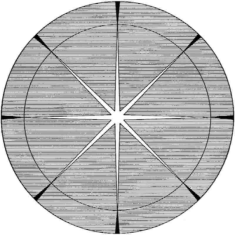
Fig.
453.—Polar projection of the earth’s hemisphere showing the theoretical high-latitude tension and low-latitude compression involved in a change of rotation from 3.82 hours to the present rate. The figure is drawn to true scale as seen from a point above the pole, and in consequence the equatorial tract is foreshortened. The black triangles show compression reduced in length by foreshortening; the white show tension in essentially true proportions to the high-latitude areas. The neutral line between the areas of compression and of stretching lies at 33° 20′ latitude.
While the doctrine of tidal retardation is theoretically sound, and while the relations of the moon to the earth have probably been appreciably affected by tidal action, geological evidence indicates that it has not been sufficiently effective in producing crustal deformations to be clearly detected by its own distinctive results. This may be due (1) to the fact that there are compensating agencies that tend to acceleration of rotation, and (2) to the probable fact that the central rigidity of the earth is too high to give a very effective body-tide. Hence the process of retardation may have been too slow to have been geologically appreciable in the known period. The recent estimates of the effective rigidity of the earth are greater than former ones, and they may need to be modified yet further in the same direction.
Distribution of rigidity.—An important consideration in this connection is the distribution of interior rigidity. It is certain that the rigidity of the outermost part, taken as a mass, is somewhat less than that of rock of an average surface type, for it is fissured, and there is no reason to suppose that the rigidity of the rock next below the fissure zone rises at once to the rigidity of steel, and hence if the average rigidity of the whole earth is equal to that of steel, a portion of the interior must have a rigidity much higher than steel. There is probably some law of increase from surface to center, and there are theoretical grounds for thinking that it is in some way connected with the laws of pressure, density, compressibility, and temperature. All of these factors probably affect rigidity, but in different ways. The modulus of rigidity of steel is about 770 × 106 grms. per sq. cm. Milne and Gray[269] found that of granite to be 128 × 106. The ratio of the rigidity of steel to that of rock is, therefore, about 6 : 1. If it be assumed that the rigidity increases in depth directly as the density, the rigidity will nowhere reach that of steel, being only about two-thirds as much at the center. If it be assumed that the rigidity increases as the squares of the density ratios, the following values are obtained:
Distances from center in terms of radius. Densities under Laplace’s law. Density ratios. Density ratios squared. Deduced rigidities.
1.00 2.8 1 1 0.16 Steel
.75 5.7 2 4 0.6 ”
.50 8.39 3 9 1.5 ”
.25 10.27 3.7 13.7 2.3 ”
.00 10.95 3.9 15.2 2.5 ”
These values seem fairly consistent with the apparent requirements of the case.
If the distribution of rigidity were of this nature, the average rigidity would be much less than that of steel, for more than half the volume lies in the outer division, between 1.00 and .75 radius, and yet the effective resistance to tidal deformation would be high, for, according to G. H. Darwin,[270] the tidal stress-differences are eight times as great in the center as at the surface. The rigidity would, therefore, be distributed so as to be much more effective in resistance than if it were uniform. The suggestion arises here that the tidal stresses and other analogous stresses arising from astronomical sources may be in themselves the causes of some such distribution of rigidity as this. The tidal stresses are rhythmical and give rise to a kind of kneading of the body of the earth, small in measure to be sure, but persistent and rapidly recurrent. Since these stress-differences at the center are eight times those at the surface, and since also the gravitative stress at the center is 3,000,000 times that at the surface, there is a series of persistently recurring stress-differences, greatest at the center and declining outwards, superposed on enormous static stresses, also intensest at the center and declining outwards. Now, if the earth material were once made up of a mixture of minerals of different fusibility, some of which became more mobile (whether fluid or viscous) than others under the rising temperature of the interior, it seems that the more mobile portion must have tended to move from the regions of greater stress-differences to those of lesser stress-differences. The persistence and the rhythmical nature of the tidal stress-differences seem well suited to aid the mobile parts in gradually working their way outwards. At the same time the more solid and resistant portions should remain behind, and thus come to constitute the dominant material of the central regions where stress-differences were greatest, and so, as it were, concentrate rigidity there. The process may still be in action.
If it be assumed that the rhythmical stresses have thus developed a resistance to deformation proportional to their intensity, we may combine this with density to form the basis of another hypothetical distribution of rigidity, as follows:
Distances from center in terms of radius. Densities under Laplace’s law. Density ratios. Ratios adjusted to stress-differences. 1:8) Deduced rigidities.
1.00 2.8 1 1 0.16 Steel
.75 5.7 2 3.5 0.58 ”
.50 8.39 3 5.4 0.90 ”
.25 10.27 3.7 7 1.16 ”
.00 10.95 3.9 8 1.33 ”
The average rigidity is here also much less than that of steel, but its distribution is such as to render it ideally fitted to resist tidal distortion.
These hypothetical distributions of rigidity have no claims to special value in themselves, for the grounds on which they are based are quite inadequate, but they are not without importance in giving tangible form to considerations that bear vitally not only on tidal problems, but on many others connected with the internal constitution and dynamics of the earth.
Sphericity as a factor in deformation.
It is obvious that if the earth shrinks, its crust must become too large for the reduced spheroid, and must be compressed or distorted to fit the new form. The amount of distortion required for any given shrinkage is easily computed from the ratio of the radius to the circumference of a sphere, which is approximately 1 : 6.28. If, for example, the radius shortens 5 miles, each great circle must on the average be compressed, wrinkled, or otherwise distorted to the extent of about 31 miles, or, in reversed application, if the mountain foldings on any great circle together show a shortening of 100 miles, the appropriate radial shortening is 16 miles. The ratio of 1 : 6+ furnishes a convenient check on hypotheses that assign specific thrusts to specific sinkings of adjacent segments. A segment 3000 miles across, for example, such as the bottom of the North Atlantic basin, sinking three miles, about the full depth of the basin, would give a lateral thrust of about 2.2 miles, a little over a mile on each side, a trivial amount compared with the foldings on the adjacent continental borders.
The influence of the domed form of the surface.—Because of the spheroidal form of the earth, each portion of the crust is ideally an arch or dome. When broad areas like the continents are considered, it is the dome rather than the arch that is involved, and in this the thrust is ideally toward all parts of the periphery. It is probably for this reason that mountain ranges so often follow curved or angulated lines, or outline rude triangles or polygons. The sigmoidal courses of the ranges of southern Europe, the looped chains of the eastern border of Asia, and the curved ranges of the Antillean region, are notable examples. The border ranges of the Americas, of the Thibetan plateau, and of other great segments, illustrate the polygonal tendency. The general distribution of the great ranges is such that a nearly equal portion of crustal crumpling is thrown across each great circle, as theory demands. The common generalization that mountain ranges run chiefly in oblique directions, as northeast-southwest, northwest-southeast, is but a partial view of the more general fact that the lines of distortion must lie in all directions to accommodate the old crust to the new geoid, if there be equable contraction in all parts.
Theoretical strength of domes of earth-dimensions.—As the domed form of the crust has played an important part in theories of deformation, it is important to form quantitative conceptions of the strength of ideal domes having the figure and dimensions of segments of the earth’s crust. According to Hoskins,[271] a dome corresponding perfectly to the sphericity of the earth, formed of firm crystalline rock of the high crushing strength of 25,000 pounds to the square inch, and having a weight of 180 pounds to the cubic foot, would, if unsupported below, sustain only 1⁄525 of its own weight.[272] This result is essentially independent of the extent of the dome, and also of its thickness, provided the former is continental and the latter does not exceed a small fraction of the earth’s radius. If this ideal case be modified by supposing the central part of the spherical dome to rise above the average surface, the supporting power will not be materially changed unless the central elevation is a considerable fraction of the radius of the dome. Assuming a central elevation of two miles—to represent the protrusion of the continental segments—the results for domes of different horizontal extent are as follows:[273]
THEORETICAL STRENGTH OF IDEAL DOMES ARCHED TWO MILES ABOVE THE AVERAGE SURFACE OF THE SPHERE.
Diameter of given dome arched 2 miles above sphere. Multiplier of 1/525 i.e. the supporting proportion of a spherical dome. Proportion of its own weight sustained by given dome arched 2 miles above sphere.
3,000 miles 1.006 1/522
400 ” 1.396 1/376
240 ” 2.11 1/249
160 ” 3.49 1/150
80 ” 10.97 1/48
From this table it will be seen that for domes of continental dimensions the supporting strength equals only a very small fraction of the dome’s own weight. Increasing the thickness of the shell increases its actual supporting power, but the proportion is somewhat less when the whole sphere is concerned. The problem has not been worked out for domes of limited extent. For rough estimates, where the dimensions of the dome are of continental magnitude, each mile of thickness may be taken as supporting a layer of about 10 feet of its own material. If the hypothetical level of no stress be placed at 8 miles depth, the shell above this, by reason of its domed shape, could relieve its own pressure on that below to an amount equal only to the weight of about 80 feet of rock over its surface, even if its form and structure were ideal. If the shell were thick enough (817 miles) to embrace one-half the volume of the earth, its supporting power would be a little more than the weight of one and one-half miles of rock. As the radius of the earth is less than 4000 miles, the extreme supporting power reckoned on this basis would be only about 8 miles of rock-depth. It is interesting, if not significant, to observe that this depth barely reaches the minimum shrinkage that will serve, according to current estimates, to account for the crustal shortening of the great mountain-making periods. It is as if the shrinkage stresses accumulated to the full extent of the stress-resisting power of the whole sphere, and then collapsed. It is not safe, however, to give much weight to this coincidence, for higher densities and probably higher resistances to distortion come into play in the deeper horizons. If these resistances are proportional to the higher densities of the interior, the deductions would remain the same. If the effective rigidity of the earth as a whole is that of steel, as deduced by Kelvin and Darwin from tidal and other observations, or twice that of steel, as inferred by Milne from the transmission of seismic vibrations, the supporting power of the body of the earth dependent on its sphericity would be appreciably higher.
It would seem clear from the foregoing considerations that something more than the mere crust of the earth has been involved in the great deformations. Indeed it is not clear that the fullest resources of stress-accumulation which the spheroidal form of the earth affords are sufficient to meet the demands of the problem, unless the rigidity of the earth be taken at a much higher value than that of surface-rock, and this is perhaps an additional argument for the high rigidities inferred from tides and seismic waves.
In view of the doubtful competency of even the thickest segments to accumulate the requisite stresses, there is need to consider modes of differential stress-accumulation other than those dependent on sphericity.
Stress-accumulation independent of sphericity.—The principle of the dome is brought into play whenever an interior shell shrinks away, or tends to shrink away, from an outer one which does not shrink. In this case, there is a free outer surface and a more or less unsupported under surface toward which motion is possible. The dome may, therefore, yield by crushing or by contortion. The computations given above are for cases of this kind. But where the thickness becomes great and the dome involves a large part or even all of a sector of the earth, freedom of motion beneath is small, and to readjust the matter to a new form, strains must be developed widely throughout the sector, and must involve regions where the pressure is extremely great on all sides, and crushing in the usual sense impossible. Assuming the correctness of the modern doctrine that such pressure increases rigidity, instead of the older doctrine that it gives plasticity, it becomes reasonable to assume that stress-differences would be distributed throughout the mass, and bring into play a large portion of its stress-accumulating competency. When the mass yielded, it would not be by crushing, but by “flowage,” which would be more or less general throughout the mass. It might, however, be partially concentrated, as, for example, on the borders of sectors of different specific gravity.
Stress-differences may arise from physical changes within the rock itself. Whenever there is a re-aggregation of matter, or a change of any kind which involves change of volume, a change of stress is liable to be involved. It may be of the nature of relief or of intensification. In an earth built up by the haphazard infall of matter, a very heterogeneous mass must result, and the subsequent changes may be supposed to be intimately distributed through the mass, being slight at any point, but present at innumerable points. An immeasurable number of small stress-differences may, therefore, be developed throughout the mass. Until these overmatch the effective strength of the mass, they may continue to accumulate. These are not necessarily connected with stresses that arise from sphericity, and may work more or less independently of them. It is not improbable that the great stress-accumulating power of the globe finds an essential part of its explanation in supplemental considerations of this kind, and not wholly in its spheroidal form.
The actual configuration of the surface.—The foregoing computations relative to the power of shells of the earth to sustain pressures are based on ideal forms and structures that are not realized in fact. How far the earth fails to conform to these conditions must now be considered. When compared with the earth as a whole, the inequalities of its surface are trivial. If the great dynamic forces acted through the whole or the larger part of the body of the earth, the configuration of the surface can be supposed to have done little more than influence the location of the surface deformations and their special phases. But if the forces were limited to a crust of moderate thickness, the configuration of the surface is a matter of radical importance.
Concave tracts.—There is need, therefore, to inquire if any considerable breadth of the crust is outwardly plane or concave, for the principle of the dome is obviously not applicable to a plane or concave surface. To be a source of fatal weakness, the concavity must be broad enough to cause the planes of equal cooling, the isogeotherms, to be concave to considerable depths. For example, if the hypothetical level of no stress is eight miles below the surface, as computed on certain assumptions, the concave portion must be so broad that the isogeotherms will also be concave outward at something near that depth; in other words, the main part of the zone of thrust must be concave. A narrow concavity at the surface, such as an ordinary valley in a portion of the crust that has the average convexity, would not seriously depress the isogeotherms, or affect the zone of thrust, but a valley several times eight miles (level of no stress) in breadth would. For inspecting the surface of the earth in this regard, it is convenient to know what amounts of fall below the level surface give a true plane for given distances. These are shown in the following table:[274]
Length of arc in miles. Length of normal to chord at middle point in Average fall of true plane from level plane per mile, in feet. Greater fall gives concavity.
Feet. Fathoms.
25 100.3 16.7 8.
50 432. 72. 17.3
75 913.4 152.2 24.3
100 1,684. 280.7 33.7
150 3,748.8 624.8 49.9
200 6,674. 1,112.3 66.7
250 10,369.9 1,728.3 82.9
300 14,942. 2,490.3 99.6
400 26,664. 4,444. 133.3
500 41,659. 6,943. 166.6
Applying these criteria to the surface of the lithosphere, it is found that concave tracts from 100 to 300 miles in breadth are not uncommon. The more notable of these are shown in black on the accompanying map, Fig. 454, and two typical ones are shown in cross-section in Figs. 455 and 456. It is to be observed that concave tracts border the continents very generally. They are connected with the descent from the continental shelf to the abysmal basins, and are unsymmetrical. Notable concavities are found in some of the great valleys on the continental platforms. The basins of Lake Superior, Michigan, Huron, and Ontario are in part concave; so are Puget Sound, the Adriatic, and the Dead Sea; so also are the valleys of California, of the Po, and of the Ganges, when the adjacent mountains are included. Some of the “deeps” of the bottom of the ocean are notably concave. Fig. 455, a cross-section of the Challenger Deep, drawn to true scale and convexity, shows the nature of the phenomenon. The breadth is here 300 miles, and the depression below a true plane is 11,400 feet. The lower line of the figure shows the approximate position and form of the normal isogeotherm about ten miles below the surface. Assuming equal conductivity in all parts, it is clear that the isogeotherms must be concave upwards for a considerable distance below ten miles. Unless the shell of thrust is much more than ten miles thick, these concave portions should yield as fast as cooling below them permits, and no stresses arising from convexity could be accumulated.
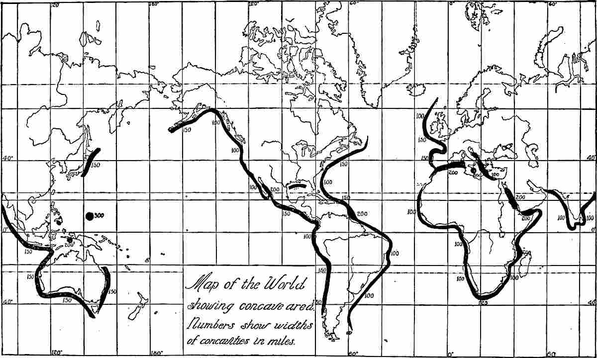
Fig.
454.—Map of the world, showing in black the chief submarine concavities of the lithosphere. (Prepared by W. H. Emmons.)

Fig.
455.—Section of the Challenger Deep from an island on the Caroline plateau,
a
, to an island on the Ladrone plateau,
b
,
drawn to a true scale
, showing the real concavity of the surface of the lithosphere for a breadth of 300 miles. The upper line represents the sea surface, a natural level. The next line below represents a true plane, eliminating the curvature of the sea surface. The third line represents the bottom of the deep. By comparison with the line above, its true concavity may be seen. The lowest line represents an isogeotherm at about 10 miles below the surface; i.e. appreciably below “the level of no stress,” as usually computed, showing that the whole thrust zone is concave outwards, if it is limited to surface cooling as usually computed. (Prepared by W. H. Emmons.)

Fig.
456.—Section through the Atlantic coastal plain, the continental shelf, and a portion of the abysmal bottom,
drawn to a true scale
, showing that the surface of the lithosphere drops below a true plane tangent to the continental shelf and the ocean-bottom. The upper line represents the surface of the coastal plain at the left and of the ocean at the right. The lower line represents the sea-bottom, and the middle line a true plane tangent to the shelf and the sea-bottom. The breadth of the concave tract varies from 100 to 150 miles. (Prepared by W. H. Emmons.)
These concavities of surface are so extensive and so widely distributed over the globe that no part of the outer shell can be supposed to be capable of accumulating notable stresses unless rigidly attached to the earth-body below. In other words, so far as sphericity is concerned, the crust must ease all its stresses nearly as fast as they accumulate, if, as usually assumed, it rests on a contracting or mobile substratum.
Surface cooling under these conditions should give only feeble thrusts, developed and eased nearly constantly. Such movements should be admirably adapted to give those gentle, nearly constant subsidences that furnish the nice adjustments of water-depth required for the accumulation of thick strata in shallow water, and those slow upward warpings that renew the feeding-grounds of erosion, the necessary complement of the deposition. These gentle, nearly constant movements mark every stage of geological history, and constitute one of its greatest though least obtrusive features. But if superficial stresses arising in this way are eased in producing these effects, they cannot accumulate to cause the great periodic movements.
Even where the crust is not concave, it is so warped and so traversed by folds and fault-planes that its resistance to thrust is relatively low, and it should, therefore, warp easily and at many points, if the thrust be confined to a superficial crust.
General conclusion.—When to the weakness of the crust, as computed under ideal conditions, there is added the weakness inherent in these concave and warped tracts, the conclusion seems imperative that while the crust is the pliant subject of minor and nearly constant warpings, such as are everywhere implied in the stratigraphic series, it is wholly incompetent to be the medium of those great deformations which occur at long intervals and mark off the great eras of geologic history. These great deformations apparently involve the whole, or a large part, of the body of the earth, and seem to require a very high state of effective rigidity.
General references on crustal movements.—Babbage, Jour. Geol. Soc., Vol. III (1834), p. 206 Lyell, Principles of Geology, Vol. II, p. 235; Mallet, Phil. Trans. (1873), p. 205; Reade, Origin of Mountain Ranges, and Evolution of Earth Structure; Fisher, Physics of the Earth’s Crust; Dutton, Greater Problems of Physical Geology, Bull. Phil. Soc. of Washington, Vol. XI, p. 52, also Amer. Jour. of Sci., Vol. VIII (1874), p. 121, and Geology of the High Plateaus of Utah (1880); Jamieson, Quar. Jour. Geol. Soc. (1882), and Geol. Mag. (1882), pp. 400 and 526; Heim, Mechanismus der Gebirgsbildung; Marjerie and Heim, Les Dislocations de l’Écorce terrestre (1888); Shaler, Proc. Boston Soc. Nat. Hist., Vol. XVII, p. 288; Dana, Manual of Geol., 4th ed., p. 345 et seq.; Woodward, Mathematical Theories of the Earth, Smithsonian Rept. for 1890, p. 196; Willis, The Mechanics of the Appalachian Structures, 13th Ann. Rept. U. S. Geol. Surv., Pt. II (1893), pp. 211–282; LeConte, Theories of Mountain Origin, Jour. Geol. Vol. I (1893), p. 542; Gilbert, Jour. Geol., Vol. III (1895), p. 333, and Bull. Phil. Soc. of Washington, Vol. XIII (1895), p. 31; Van Hise, Earth Movements, Trans. Wis. Acad. Sci., Arts and Let., Vol. II (1898), pp. 512–514; Estimates and Causes of Crustal Shortening, Jour. Geol., Vol. VI (1898), pp. 29–31; Relations of Rock Flowage to Mountain Making, Mon. XLVII, U. S. Geol. Surv. (1904), pp. 924–931; A. Geikie, Text-book of Geology, 4th ed., pp. 672–702.