Chapter III
Reading edition
THE WORK OF RUNNING WATER.
Familiar phenomena, both of land and sea, reveal the constant activity and importance of water as a geologic agent. Even when there is no precipitation the moisture in the air influences its activity in certain ways. Just as iron “rusts” more readily in moist air than in dry, so changes in other mineral substances are influenced by atmospheric humidity. Where precipitation takes place the results are more obvious. The passing shower works changes in the surface of the land, striking in proportion to the rate and amount of precipitation. The rains feed the streams, and every stream is modifying its bed, and with increasing rapidity as its current is swollen. Even the moisture which is precipitated as snow works its appropriate results. Before it melts it protects the surface against other agents of change; but if it accumulates in sufficient quantity in appropriate situations, it may give rise to avalanches and glaciers, which, like running water, degrade the surface over which they pass.
A part of the water which falls as rain, and a part of that which results from the melting of snow and ice, sinks into the soil and into the rock below, becoming ground water. It is this ground water which especially justifies the name hydrosphere, often applied to the waters of the earth, for it literally forms a spherical layer in the outer portion of the solid part of the earth. During the stay of the water beneath the surface it effects changes in the rocks through which it passes, dissolving mineral matter here and depositing it there, substituting one substance for another in this place, and effecting new chemical combinations in that. Slow as these processes are, they have worked wondrous changes in the course of the earth’s history.
When the waters are gathered together in ponds, lakes, and oceans, they are still active, and the results of their activity are seen along the shores, where winds and waves produce their chiefest effects. Even the ocean currents, far from land, and the processes of the deep sea, are not without their effect on the course of geological history.
The work of the surface waters, ground (underground) waters, standing waters, and ice will be considered in order.
RAIN AND RIVER EROSION.
Rain and river erosion began when the first rains fell on land surfaces. Neither the location nor the nature of the first land surface is known. There is little reason to believe that the ocean was ever universal, but there is reason to believe that most land areas have at some time or other been covered by the sea. The prevalent conception that land areas which were once submerged came into existence by being elevated above sea-level, should be supplemented by the alternative conception that submerged areas may have become land by the depression of the ocean basins, thus drawing off the water from the areas where it was shallow. Thus in Fig. 36 the sinking of the sea-bottom from a to b would lower the surface of the water from cc′, to dd′, and draw off the water from the surfaces cd and c′d′.

Fig.
36.—Diagram to illustrate the origin of lands by the lowering of the sea-level due to depression of the sea bottom. If the bottom is depressed from
a
to
b
the surface will be drawn down from
cc′
to
dd′
, and the surfaces
cd
and
c′d′
will become land.
Without attempting to picture the character of the original land our study of subaërial erosion may begin with an area which has just been changed from sea bottom to land. What is the nature of such a land surface? Of what material is it composed, and what is the character of its topography? Concerning its constitution something may be inferred from the nature of the deposits now found at the bottom of the sea. Near the shore and in shallow water they often consist of gravel and sand, though other materials are not wanting. Far from shore and in deep water they consist for the most part of fine sediments, some of which were washed or blown from the land, some of which came from the shells and other secretions of marine animals, some from volcanoes, and some from various other sources. The topography of the newly emerged land may have had some likeness to the topography of the sea bottom. The numerous soundings which have been made over large areas of the sea have shown that its bottom is, as a rule, free from the numerous small irregularities which affect the surface of the land. They seem to show that a large part of the ocean bottom is so nearly flat that, if the water were removed, the eye would hardly detect irregularities in the surface. This statement does not lose sight of the fact that the ocean bottom is, in certain places, markedly irregular. Volcanic peaks and striking irregularities of other sorts abound in some places. Nevertheless if the bottom of the sea could be seen as the land is, its most striking feature, taken as a whole, would be its apparent flatness.
With the topography of the sea bottom the topography of the land is, in its details, in sharp contrast. In order to get at the history of the latter, we may study the sequence of events which would follow the emergence of a portion of the former.
Subaërial Erosion without Valleys.
For the sake of emphasizing the fundamental principles involved in the work of running water, a hypothetical case will first be studied in some detail, even at the risk of elaborating processes already understood. The principles themselves will find application later in relations which are much less simple.
Let it be assumed that the area of newly emerged land is a circular dome-shaped island. The simplest possible condition is represented by assuming its slope to be the same in all directions from the center, and its materials to be absolutely homogeneous. Such an island would be subject to all the forces ordinarily operating on land surfaces. The chief agency tending to modify land surfaces is atmospheric precipitation. It will be assumed that the rain falls on the surface of the island with absolute equality at all points, and that all other forces which affect it operate equally everywhere.
The rain falling on a land area disappears in various ways; part of it evaporates, part of it sinks, and part of it runs off over the surface. If the island be composed of fine and unconsolidated materials, such as clay, the water which runs off over the surface will carry sediment down to the sea. If the island be composed of solid rock instead, exposure to the air will cause it to decay, and the products of decay, such as sand and mud, will suffer a like fate.
For the sake of a clear understanding of the processes involved, two cases may be postulated; one in which the waters of the sea remove the sediment washed down from the hypothetical island as fast as it reaches the shore, and one in which they allow it to accumulate without let or hindrance. In both cases the wear of the waves will be neglected.
1. In the first case the water flowing off over the surface (the run-off) will descend equally in all directions. It will constitute a continuous sheet of surface-water, and both its volume and its velocity will be the same at all points equally distant from the summit. Erosion accomplished by sheets of running water, as distinct from streams, is sheet (or sheet-flood) erosion.[26] Since the material of the surface is homogeneous, the wear effected by the water will be equal at all points where its velocity and volume are equal. For obvious reasons the depth of the run-off will increase from summit to base. The gradient (slope) also increases in the same direction, and the increase of volume and of gradient conspire to augment the velocity of the water, and therefore of the wear effected by it. If the thin sheet of water starting from the top of the island with relatively low velocity be able to wash off even a little fine material from the surface, the thicker sheet farther down the slope, moving with greater velocity, will be able to carry away more of the same sort of material, and the increase will be progressive from summit to base. It follows, therefore, that the surface will be worn equally at points equally distant from the summit, but unequally at points unequally distant from it. The first shower which falls on the island may be conceived to wash off from its surface a very thin sheet of material, but a sheet which increases in thickness from top to bottom. The run-off will not be stopped immediately on reaching the sea, but will displace the sea-water to some slight depth, and wear the surface some trivial distance below the normal level of the sea. The result of successive showers working in the same way through a long period of time will be to diminish the area of the island and to steepen its slopes. The results of a considerable period of erosion under these conditions are shown diagrammatically in Fig. 37, which illustrates both the diminution in area which the island has suffered, and the increase in the angle of its slopes. Immediately about it, at the stage represented by aa, Fig. 37, there is a narrow marginal platform, or submerged terrace, in place of the land area which has been worn away at or just below the level of the sea. Long successions of rains working in the same way will give the island steeper slopes, a smaller area, and a wider marginal terrace. Successive stages are shown by the lines bb and cc, Fig. 37.

Fig.
37.—Diagram to illustrate the effect of rain erosion on an island where there is no deposition or wave erosion about its borders. The uppermost curve represents the original surface, while
aa
,
bb
, and
cc
represent successive surfaces developed by sheet erosion, on the supposition that no material is deposited along the shores.
If rain falls on such an island until it completes the work which it is possible for running water to do, the island will be reduced essentially to the level of the sea, and in its place there will be a plain, the area of which will be equal to that of the original island. Its central point will be at the level of the sea, and its borders a trifling distance below it (Fig. 38). The island is gone, and in its place there is a plain as low as running water can wear it. Other agencies might come in to defeat the result just outlined, but if the island did not rise or sink after its formation, rain falling upon it would, under the conditions specified, finally bring about the result which has been sketched. The plain (Fig. 38) which succeeds the island is a base-level of erosion, though this term is also used in other ways. Under these conditions the slope of the land would remain convex at all stages, but the convex erosion profile of the land would meet a nearly straight line just below sea-level. The relative lengths of these two elements of the profile, the curve above and the straight line below, vary as erosion progresses, the convex portion becoming shorter and the other longer, The two parts of the profile taken together are concave upward at the lower end all the time, and for a greater distance from its lower end in all the advanced stages of erosion (Fig. 37).

Fig.
38.—Diagram to illustrate the final effect of rain erosion under the conditions specified in the text. The diagram expresses the final result of the processes suggested by
Fig.
37
.
In the destruction of the land under these conditions neither valleys nor hills would be developed, nor would the topography of the land be fashioned to correspond with the surfaces with which we are familiar.
It is to be distinctly borne in mind that the foregoing is a hypothetical case; it is not probable that such an island ever existed, or ever will; but that does not diminish the value of the illustration, since the principles involved are operating on every land mass, though in less simple relations.
2. The second case differs from the first in that the sediment washed down from the land is deposited about its borders. This results in the building up of a marginal platform, as shown in Figs. 39–41. As erosion goes on more sediment is washed down and deposited, partly on the narrow marginal shelf which has already been developed, and partly on its outer slope, as shown in the figures. The marginal flat is thus extended beyond the original shores of the island on the one hand, and toward its center on the other. As it develops, its inner portion, and indeed all except its outer edge (ab, Figs. 40 and 41), will be gradually built up above the level of the water. This marginal lowland is developed at a level as low as running water, under the conditions then and there present, can reduce the land. Such a surface may be said to be at grade, since running water neither wears it down nor builds it up. Its angle of slope is a function of (1) the volume of the water running over it, and (2) of the load which the water carries.
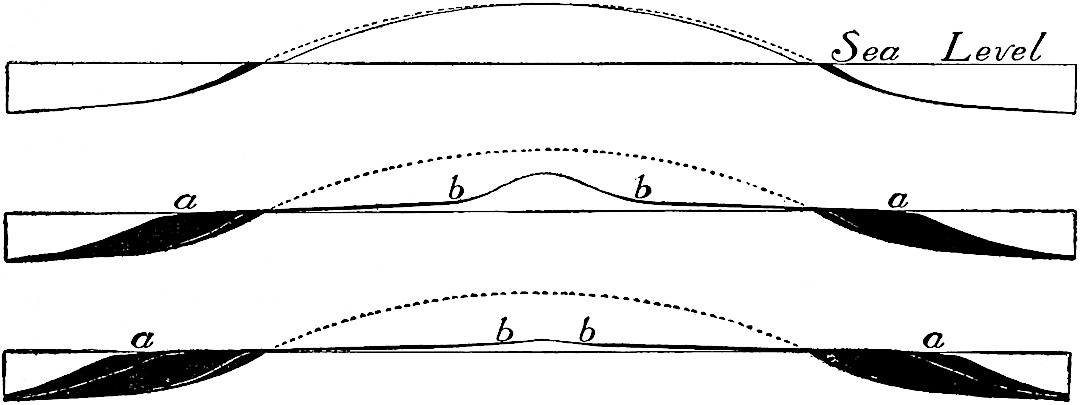
Fig.
39–41.—Diagrams to illustrate the effect of rain erosion on an island when all the eroded material is deposited about the shore. The black portions represent deposition. The dotted lines represent the original surface. The several diagrams represent successive stages in the process.
Since the marginal plain of the above illustration extends beyond the original shore of the island, the area of land is increased, though both its average elevation and its mass (above water) are reduced. In case destructive processes did not operate on the marginal graded plain the spreading and lowering suggested by Figs. 39 and 40 would go on until the central mass of the island was brought down to a gradient in harmony with that of the gently sloping border, as shown in Fig. 41. When this had been accomplished there would be a relatively large land area with low slopes (Fig. 41) in place of the smaller area with steeper ones (compare Figs. 39 and 40). The basal part of the larger island from the center to the original margin would be made up of the original material in its original position (unshaded part of Fig. 41). Its surface would be covered, least deeply near its center and most deeply near the original margin, with débris gradually shifted from higher levels, as shown in Fig. 41.
Were such an island as that shown in Fig. 41 once formed, the rain falling on it, and flowing off over its surface, would carry off its surface soil and spread it about the shores. Though the surface of the marginal flat of Fig. 40 was as low as running water could bring it at the time it was developed, the conditions of erosion have changed by the time the land reaches the conditions shown in Fig. 41, and the same amount of rainfall may now be effective in erosion. In the first case (Fig. 40) the water descending from the higher part of the land brought down sediment and started across the flat with a load. Its energy was consumed in transporting what it had, not in getting new material. In the second case (Fig. 41) the water flowing over the gently sloping surface has no initial load, and its energy is therefore available for erosion. Under continued rainfall, the area of the land shown in Fig. 41 would be increased as before by successive marginal deposits (see Fig. 42), and at the same time its average height would be reduced. The lowering and enlarging of the island would continue until the whole surface was brought so nearly to the level of the sea that water would cease to run over it with sufficient velocity to carry away even the fine material of its surface. Such a surface, brought down as low as running water can degrade it, is also (see p. 57) a base-level. It will be seen from the foregoing illustrations that a graded surface may pass into a base-level, with no sharper line of demarkation than that which separates a mature man from an old one. In this case, as in the preceding, the island has been base-leveled, but still without the formation of valleys or hills.

Fig.
42.—Diagram to illustrate the result of the continuation of the processes shown in
Figs.
39–41.
Both the preceding hypothetical cases make it clear that, from the point of view of erosion, every drop of water which runs off over the surface of the land has for its mission the getting of the land into the sea. Under ordinary conditions surface drainage must fail to bring a land area altogether to sea-level, the absolute base-level of subaërial forces; but it is not simply the water which runs off over the surface which degrades the land. That which sinks beneath the surface contributes to the same end by slowly dissolving mineral matter below the surface, and finally carrying it to the sea. In this way the reduction of land areas to sea-level may be completed.
The rain-water which evaporates from the surface without sinking beneath it does not effect much wear; but the water thus evaporated is subject to reprecipitation, so that, in the long run, it may assist in the work which has been sketched. Thus it is not simply the waters which run off over the surface of the land, but all which fall upon it, which unite to compass its destruction.
The Development of Valleys.
By the growth of gullies.—Had the slopes of the hypothetical island not been absolutely uniform the processes of erosion would have been different. Let the departure from uniformity be supposed to consist of a single slight meridional depression near the base of the island (Fig. 43). As the rain falls it will no longer run off equally in all directions. A greater volume will flow through the depression than over other parts of the surface having the same altitude, and the greater volume of water along this line will give greater velocity, greater velocity will occasion greater erosion, and greater erosion will deepen the depression. The immediate result is a gully or wash (Fig. 44). So soon as the gully is started it tends still further to concentrate drainage in itself, and is thereby enlarged. The water which enters it from the sides widens it; that which enters at its head lengthens it by causing its upper end to recede; and all which flows through it, so long as its bottom is above base-level, deepens it. The enlarged gully will gather more water to itself, and, as before, increased volume means increased velocity, and increased velocity increased erosion. As the gully grows, therefore, its increased size becomes the occasion of still further enlargement.

Fig.
43.—Diagram showing a slight meridional depression in the surface of an otherwise even-sloped island.
Continued growth transforms the gully into a ravine, though between a gully and a ravine there is no distinct line of demarkation. But growth does not stop with ravine-hood. Water from every shower gathers in the ravine, and, flowing through it, increases its length, width, and depth, until it reaches such proportions that the term ravine is laid aside, as childhood names are, and the depression becomes a valley.
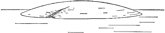
Fig.
44.—Diagram illustrating the development of a gully, starting from the condition shown in
Fig.
43
.
It was assumed in the preceding paragraphs that the single depression in the slope was meridional and low on the slope, but almost any sort of depression in almost any position would bring about a similar result, since it would lead to concentration of the run-off. Had the original surface been interrupted by ridges instead of depressions, the effect on valley development would have been much the same, for a ridge, like a depression, would, in almost any position, occasion the concentration of the run-off, and so the development of valleys. Under the conditions represented in Fig. 44 the lengthening of the drainage depression is effected chiefly at its upper end, the head of the valley working its way farther and farther back into the land. This method of elongation is known as head erosion. But the lengthening of the valley is not always wholly by head erosion. The gully normally begins where concentration of run-off begins, and if this were not at sea-level, the gully might be lengthening at both ends at the same time. This would have been the case, for example, had the original depression of Fig. 43 been half-way up the slope of the island.
If while the slopes of the island were absolutely uniform its surface material failed of homogeneity, the result would be much the same as if the slopes were unequal. If the material lying along a certain meridian of the island be slightly softer than that over the rest of the surface, the run-off, which would at the outset be equal on all sides, would effect more erosion along the line of the less resistant material than elsewhere. The result would be a depression along this line, and, once started, the depression would be a cause of its own growth. If the soft material were disposed in any way other than that indicated, the final result would be much the same, for it would quickly give origin to a depression which would lead to the concentration of the surface-waters, and this is the condition for the development of a gully, a ravine, and finally a valley.
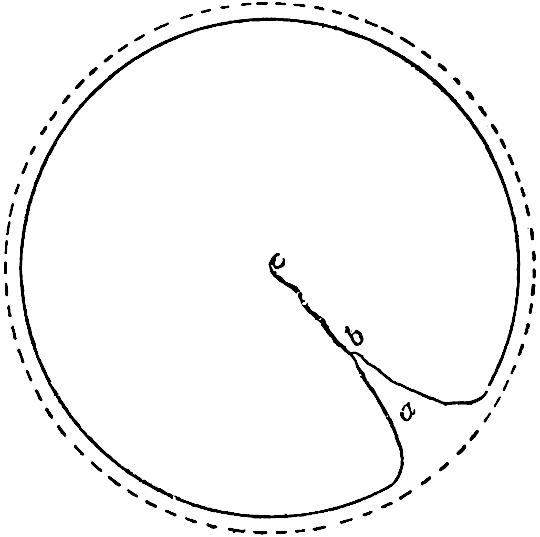
Fig.
45.—Diagram to illustrate the effect of sheet and stream erosion on the outline of an island when no deposition takes place about its borders. The dotted line represents the original outline of the island, the full line its border at a later time. The stream develops a reëntrant (bay) in the outline.
In the presence of sufficient rainfall, either heterogeneity of slope or of material will therefore occasion the development of valleys. If the lack of uniformity appears at but a single point there will be but a single valley. If it appears at many points the number of valleys will be large. Since it is incredible that a land mass of perfectly homogeneous material and of absolutely uniform slopes ever existed, it is believed that every land mass, affected for any considerable length of time by rain, has had valleys developed in it. The degree of heterogeneity of material and slope is usually so great as to lead to the development of many valleys, even on areas which are not large; but for the sake of emphasizing the simpler elements of the complex processes of stream work, the hypothetical case of an island with but a single valley, and that without tributaries, may first be studied. Under these conditions two cases may be considered, the one where there is no deposition about the island, and the other where deposition takes place.
1. If all the material eroded from the surface of such an island, both in and out of the valley, were carried well beyond the borders of the land before being deposited, the edge of the island would recede from its original position toward the center, as illustrated by Figs. 37 and 45; but the recession would be most rapid where the valley joins the sea (Fig. 45). At this point therefore a reëntrant would be developed (a, Fig. 45), and the island would lose its circular outline. Continued erosion would cause the shore-line to retreat on all sides, but fastest at the lower end of the valley, and the final result would be a base-level differing from that developed under the conditions specified on p. 60, in that the last part to be brought low would not be the center of the original island.
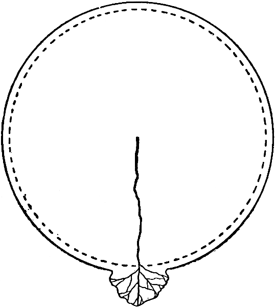
Fig.
46.—Diagram showing the outline of an island as modified by sheet and stream erosion where eroded material is deposited at the shore. The dotted line represents the original outline; the full line, a later one. The excess of deposition at the end of the valley causes a projection of land into the sea.
Under the foregoing conditions the profile of that part of the valley which is above sea-level (cb) would be convex, following the analogy of sheet erosion on a hypothetical island of uniform slopes and homogeneous material with no marginal deposition. Its side slopes, likewise developed under the influence of running water augmented in volume from top to bottom, would also be convex.
2. If the sediment washed down from the land is deposited about its borders, both the outline of the island and the profile of the valley will be altered. Deposition at the debouchure of the valley follows the same principles as deposition elsewhere; but if all the sediment brought to the sea be deposited at the shore, the seaward extension of the land by deposition would be more rapid opposite the valley than elsewhere, and the island would lose its circular outline, and develop some such form as is shown in Fig. 46. In this case the profile of the upper end of the valley, and the upper parts of its side slopes, as well as the upper parts of the extra-valley slopes of the island, are convex (compare Figs. 39 and 40); but the convexity above is exchanged for concavity below, the change beginning at the point where downward erosion of the descending waters is checked. As a valley lengthens, the larger part of its profile becomes concave (compare the profiles of Figs. 39 to 41), but the extreme upper end still remains convex. Since the side slopes of a valley are much shorter than its lengthwise slope, a larger proportion remains convex. Under the conditions here discussed the change from convexity above to concavity below would begin at about the point where deposition begins.[27]
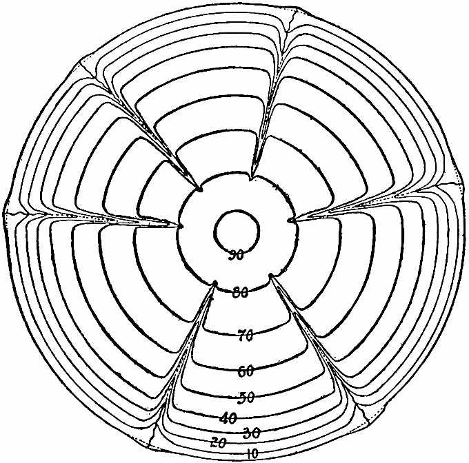
Fig.
47.—Diagram representing several meridional valleys developing in a circular island. The valleys are all young and narrow. All are making deposits at their debouchures.
The deposition at the debouchure of the valley, and later above the debouchure, will follow the same course as about the island under the conditions already discussed (pp. 61, 62).
Limits of growth.—In all cases there are limits in depth, length, and width, beyond which a valley may not grow. In depth it may reach base-level. At the coast, base-level is sea-level,[28] but inland it rises by a gentle gradient. In length, the valley will grow as long as its head continues to work inland. In the case represented by Figs. 45 and 46 the head of the valley would not cease to advance when the center of the island was reached, though beyond that point head erosion would not be more rapid than lateral erosion on either side. If but a single valley affected a land area the limit toward which it would tend, and beyond which it could never pass, would be the length of the land area in the direction of the valley’s axis. In width, a valley is increased by the side cutting of the stream, by the wash of the rain which falls on its slopes, and by the action of gravity which tends to carry down to the bottom of the slope the material which is loosened above by any process whatsoever. If there be but one valley in a land area its limiting width is scarcely less than the width of the land itself.
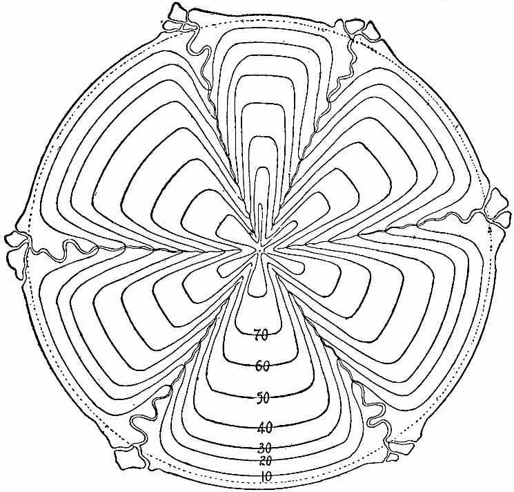
Fig.
48.—Same as
Fig.
47
, with the valleys more developed. The dotted line represents the original outline of the island. Its area is being extended by deposition everywhere, but most at the debouchures of the streams.
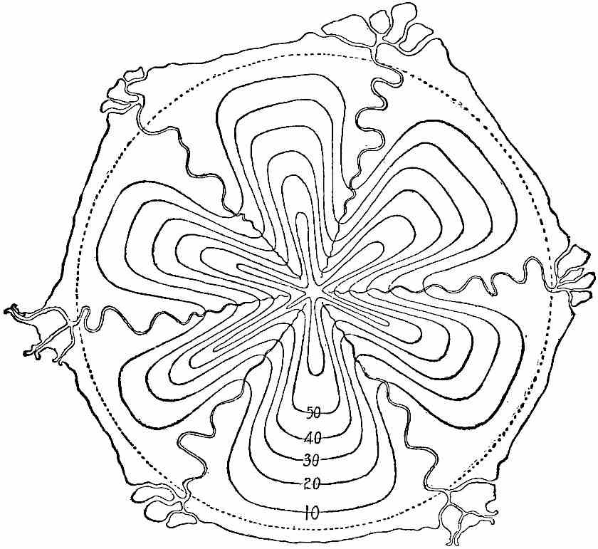
Fig.
49.—A later stage of the island shown in
Fig.
48
.

Fig.
50.—Diagram to illustrate the lowering of a divide without shifting it. The crest of the divide is at
a
,
b
, and
c
successively. If erosion were unequal on the two sides, the divide would be shifted.
Had there been several initial meridional depressions instead of one in the island, or had there been several meridional belts where the material of the surface was less resistant than elsewhere, several valleys would have been developed, converging toward the center (Fig. 47). If the conditions were such as to allow of the equal development of valleys on all sides of the island, each would be lengthened by head erosion until it reached the center of the island, where the permanent divide between their heads would be established. Each would be widened by all the processes which widen valleys, and their widening would narrow the intervening areas (Figs. 48 and 49). Under conditions of equal erosion the limits of width for each valley would be the centers of the ridges on either side, and here the divides between them would be permanently established. Though erosion would continue even after the crest of the ridge had been narrowed to a line, the permanence of the divide would follow from the fact that erosion would be equal on both sides of this line, and its effect would be to lower the divide, but not to shift it horizontally (Fig. 50). The limits in length and width are therefore not the same where there are several valleys as where there is but one. The limit in depth, however, remains the same, and the final result of erosion, proceeding along these lines, would be the base-leveling of the land, leaving a plain but slightly above sea-level. The plain would not be absolutely flat, though its relief would be very slight, and the higher parts would be along the lines of the divides between the streams (Fig. 51. Compare also Fig. 42). Many valleys would occasion more rapid degradation than few, and the period of base-leveling would be correspondingly shortened.
Had the initial depressions which gave origin to the valleys had positions other than meridional, the valleys would have had other and less regularly radial courses, but the final result of their development would have been the same.
It is not to be inferred that the method of valley development which has been sketched is the only one. The processes of valley development are complex, and the history of some valleys has run a different course; yet the processes outlined above are in operation in all cases, and they were probably the most important ones in the development of the first drainage system on any land surface. As will be seen in the sequel the history of valleys is subject to serious accidents, and they are often of such a nature as to mask the simplicity of the more normal processes.
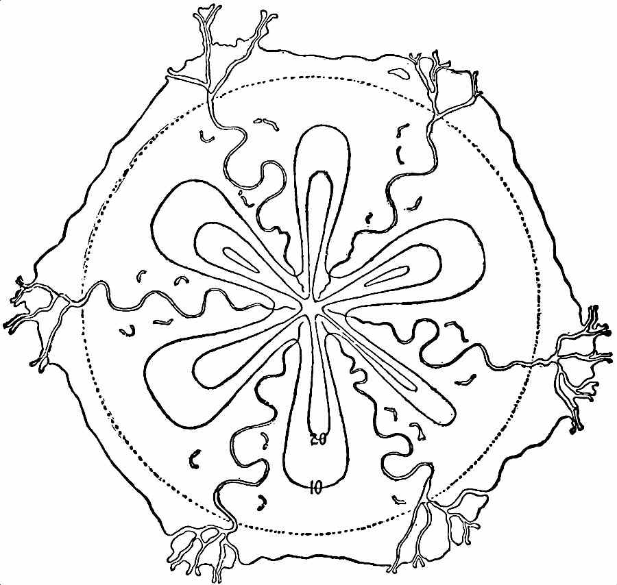
Fig.
51.—Diagram illustrating the further development of
Fig.
49
. The land here has been reduced greatly, though not yet to base-level.
The permanent stream.—From the foregoing discussion, it is seen that a valley may be developed by the run-off of successive showers. If supplied only from this source surface streams would cease to flow soon after the rain ceased to fall, and a valley might attain considerable size without possessing a permanent stream. How does the valley developed by the run-off of successive showers come to have a permanent stream? The answer to this question involves a brief consideration of that part of the rainfall which sinks beneath the surface.
If wells be sunk in a flat region of uniform structure and composition the water in them is generally found to stand at a nearly common level. The meaning of this fact is not far to seek. If a hole 60 feet deep fills with water up to a point 20 feet from the surface, it is because the material in which the well is sunk is full of water up to that level. When the well is dug the water leaks into it, filling the hole up to the level to which the rock (or subsoil) is itself full. This level, below which the rock and subsoil (down to unknown depths) are full of water, is known as the ground-water level, ground-water surface, or water-table.
The ground-water level fluctuates. In a wet season it rises, because more water has fallen and sunk beneath the soil; but several processes at once conspire to bring it down again. Where there is growing vegetation its roots draw up water from beneath, and evaporation also goes on independently of vegetation. The water is drawn out through wells and runs out through openings. It may also flow underground from one region to another where the ground-water surface is lower. All these processes depress the ground-water surface.
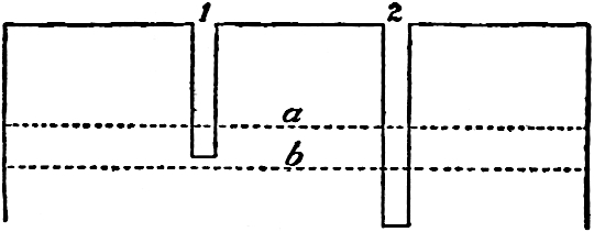
Fig.
52.—Diagram illustrating the fluctuation of a ground-water surface.
a
= wet-weather ground-water level;
b
= ground-water level during drought. Well No. 1 will contain water during the wet season, but will go dry in times of drought. Well No. 2 will be permanent.
A well sunk to such a level as to be supplied with abundant water in a wet season may go dry during a period of drought because the ground-water level is depressed below its bottom. Thus either well shown in Fig. 52 will have water during a wet season when the water-level is at a; but well No. 1 will go dry when the water surface is depressed to b.
The principles applicable to wells are applicable to valleys. When a valley has been deepened until its bottom reaches below the ground-water level, water seeps or flows into it from the sides. The valley is then no longer dependent on the run-off of showers for a stream. It will be readily seen that at some stage in its development, the bottom of a valley may be below the ground-water level of a wet season without being below that of a dry one. Thus the valley represented in cross-section by the line 2–2, in Fig. 53, will have a stream when the ground-water level is at aa, but none when this level is depressed to bb. If the rainfall of the year were concentrated in a single wet season, the intermittent stream would flow not only during that season, but for so long a time afterward as the ground-water level remained well above the valley bottom. In regions subject to frequent and short periods of heavy precipitation, alternating with droughts, the periods of intermittent flow may be many and short. Since the precipitation of many regions varies greatly from year to year, it follows that a stream may flow continuously one year and be intermittent the next. Many valleys in various parts of the earth are now in the stage of development where their streams are intermittent.
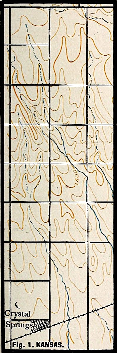
As a valley containing an intermittent stream becomes deeper, the periods when it is dry become shorter, and when it has been sunk below the lowest ground-water level, it will have a permanent stream (3, Fig. 53). Since a valley normally develops headward, its lower and older portion is likely to acquire a permanent stream, while its upper and younger part has only an intermittent one (Fig. 47 and Fig. 1, Pl. III, near Anthony, Kan. The intermittent part of the stream is indicated by the dotted blue line). For the same reason the head of a stream is likely to be farther up the valley in wet weather than in dry. So soon as a valley gets a permanent stream, the process of enlargement goes on without the interruption to which it was subject when the supply of water was intermittent.
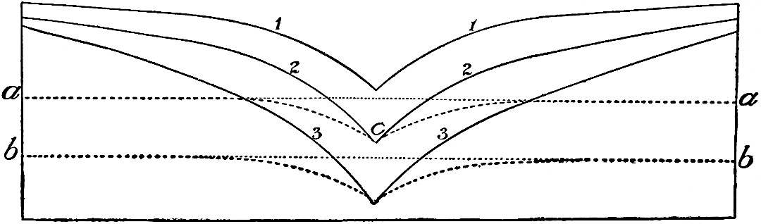
Fig.
53.—Diagram to illustrate the intermittency of streams due to fluctuations of the ground-water level. The water level
aa
would be depressed next the valley 2–2 by the flow of the water into the valley. The profile of the ground-water surface would therefore be
aca
rather than
aa
.
In general a permanent stream at one point in a valley means a continuous stream from that point to the sea or lake which the valley joins; but to this rule there are many exceptions. They are likely to arise where a stream heads in a region of abundant precipitation, and flows thence through an arid tract where the ground-water level is low, and evaporation great. In such cases, evaporation and absorption may dissipate the water gathered above, and the stream disappears (Fig. 2, Pl. III, near Paradise, Nev.).
PLATE III.
U. S. Geol. Surv. Scale, 2+ mile per inch. Fig. 1. KANSAS.
U. S. Geol. Surv. Scale, 4+ mile per inch. Fig. 2. NEVADA.
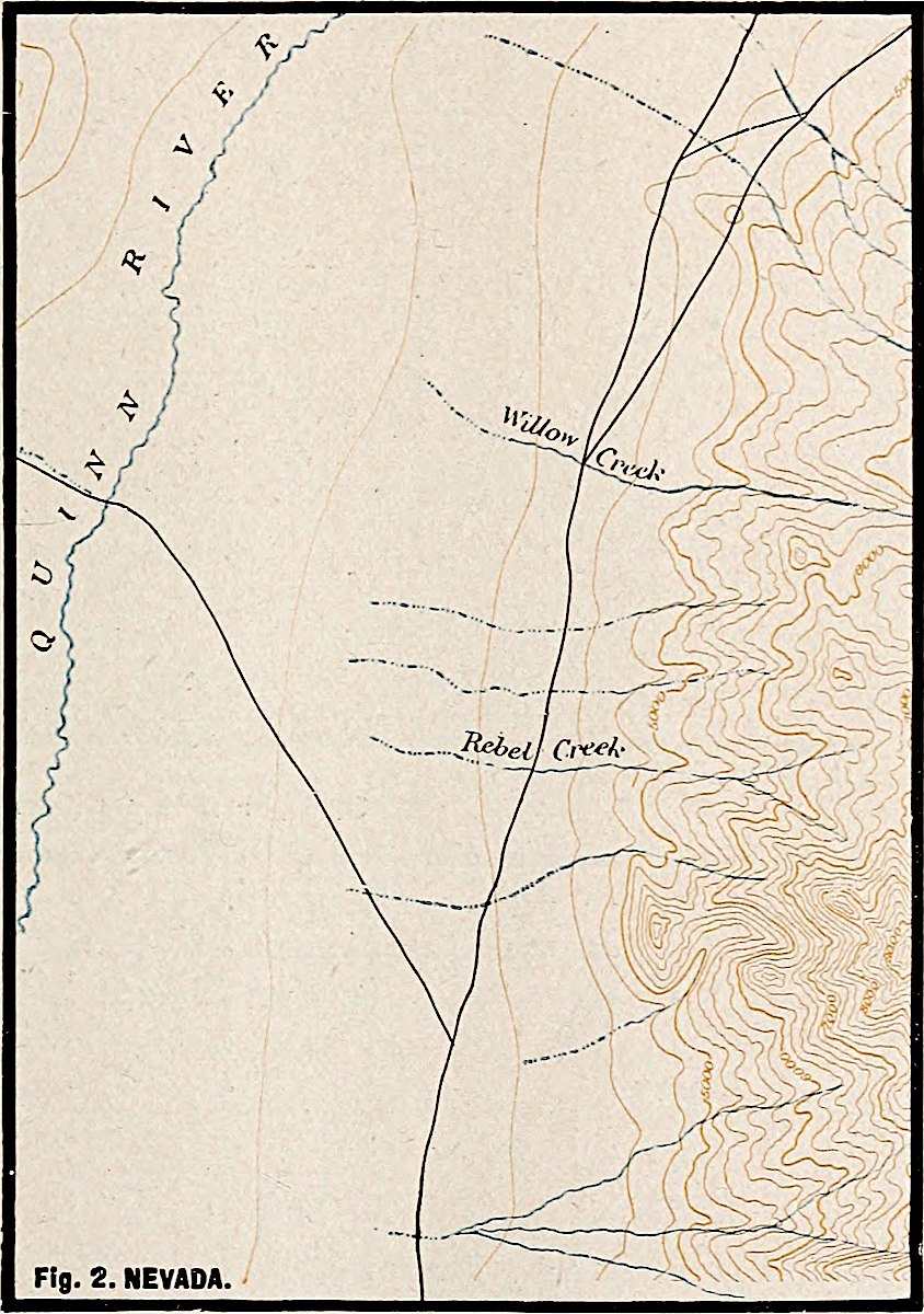
PLATE IV.
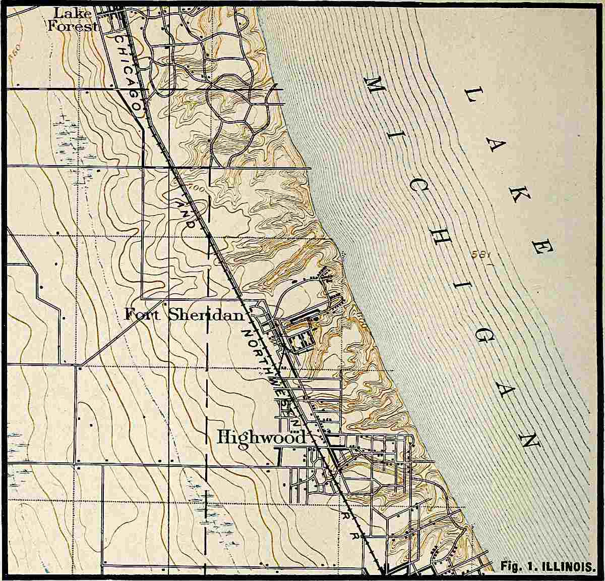
U. S. Geol. Surv.
Scale, 1+ mile per inch.
Fig.
1. ILLINOIS.
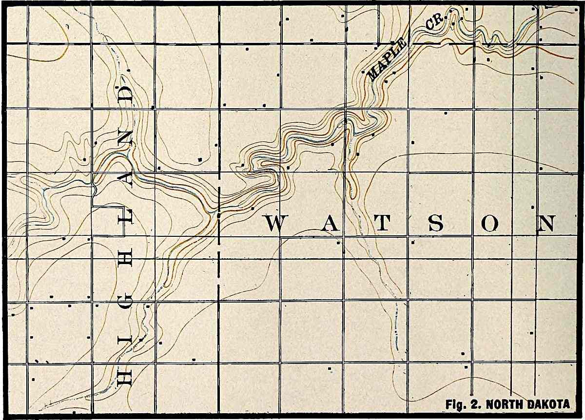
U. S. Geol. Surv.
Scale, 2+ mile per inch.
Fig.
2. NORTH DAKOTA.
Other modes of valley development.—If as a new area of land emerges from the sea its surface has a depression without an outlet, and such an assumption is by no means improbable, the depression would be filled with sea-water. The inflowing water from the surrounding land might fill the basin to overflowing, and the outflow, finding exit at the lowest point in the rim of the basin, would flow thence toward the sea. Such a stream would develop a valley, the history of which would be somewhat different from that which has been sketched. Instead of developing headward from the sea, the valley would be in process of excavation all the way from the initial basin to the sea at the same time (Fig. 54). The upper end of the valley might ultimately be cut to the level of the bottom of the basin, when the lake would disappear. The head of the valley might then work back across the former site of the lake into the territory beyond. Valleys might have developed above the lake before it was drained, and after this event, such valleys would make connections with the valley below (Fig. 55). A valley developed in this manner is not simply a gully grown big by head erosion, and the valley would not precede the stream.
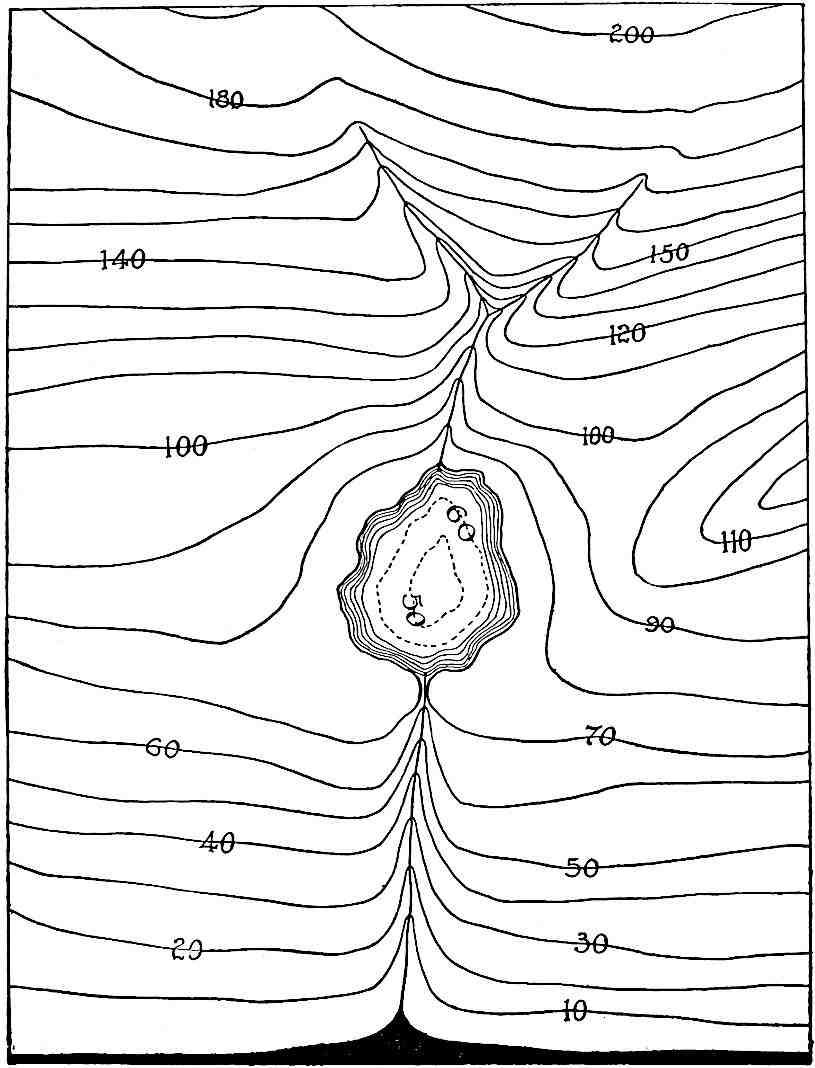
Fig.
54.—Diagram to show how a valley may be developing all the way from a water-filled basin (lake) to the sea at the same time. Small valleys leading to the lake are also developing. The black area = the sea.
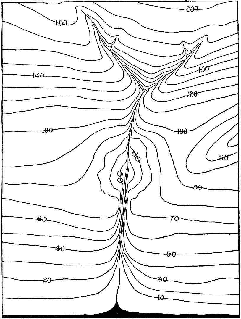
Fig.
55.—The stream leading out from the lake (
Fig.
54
) has drained the lake, and the valleys above and below the site of the former lake have united.
If a surface of land were notably irregular before valleys were developed in it, there might be many lakes, and the flow from a higher lake might pass to a lower. If the lakes were ultimately drained, the several sections of the valley would be joined to one another without intervening basins. In certain regions, especially those which have been affected by continental ice-sheets, this has been a common method of valley development in post-glacial time. In this case also the stream precedes its valley, and not the valley its stream. Many post-glacial valleys, on the other hand, antedated their permanent streams, as in the cases first described.
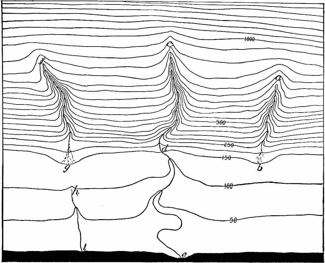
Fig.
56.—Diagram showing the phases of valley development described in the text.
If the gradient of a slope on which valleys are to develop is notably unequal, though without basins, the development of valleys may follow somewhat different lines. If on emergence the seaward part of a new land area assumes the form of a plain, bordered landward by a steeper slope (Fig. 56), the most notable early growth of the valleys would be on the latter. The run-off would develop gullies on the steep slope, but on reaching the plain below the velocity of the water would be checked, and it would drop much of the detritus washed down from above. This deposition would build up (aggrade) the surface, and much or even all the water might sink into and seep through the débris thus deposited, and disappear altogether from the surface, as at b, Fig. 56. This would be most likely to occur where the débris is abundant and coarse, and the precipitation slight. If the water disappears at the base of the mountain (see Fig. 2, Pl. III), the early growth of the valley may be confined to the steep slope remote from the sea (ab, Fig. 56); but on the slope where the valley is growing there will be headward lengthening, as in the general case already considered. If the surface drainage does not disappear at the base of the steep slope, the run-off will find its way over the plain along the lowest accessible route to the sea (de, Fig. 56). In this case the valley may be growing throughout its length at the same time.
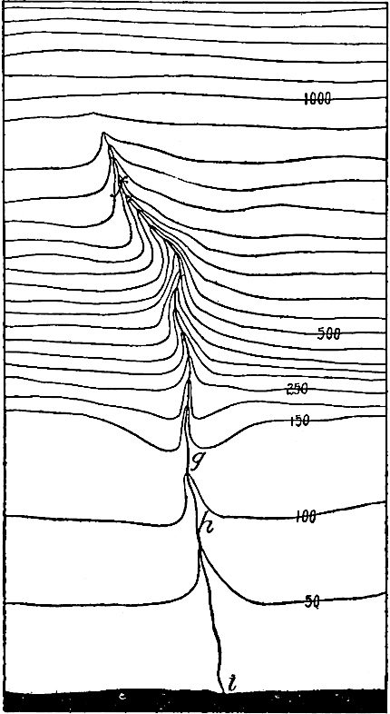
Fig.
57.—Diagram representing the further development of the valleys
fg
and
hi
in
Fig.
56
. The head of the latter (
Fig.
56
) has worked back until it has reached the lower end of the former.
The conditions represented by ab, Fig. 56, may be no more than temporary. Sooner or later a valley developing headward across the plain (hi, Fig. 56) may provide a channel for the water descending from the higher land beyond. In this case the valley develops in sections, the one on the slope above, the other on the plain below, and their union (compare fghi, Fig. 56, with Fig. 57) results from their growth.
The principles here sketched have been in operation wherever land areas were so elevated as to give rise to unequal slopes, and this has perhaps been the rule rather than the exception. The results effected by the operation of these principles would of course be dependent on the varieties of slope, on the abruptness with which a slope of one gradient gave place to another, on the texture of the rock, the amount and distribution of precipitation, etc., etc.
In the preceding paragraphs the lengthening of a valley at its upper end by head erosion has been repeatedly referred to. If all valleys began their development at the sea and lengthened headward, it might seem that their seaward ends should be their oldest parts; but since the development of valleys is begun somewhat promptly after the land appears above the sea, and since the emergence is generally gradual, that part of a valley which is at the seashore at one time may be far inland a little later, because the land has been extended seaward. On an emerging land area therefore the normal growth of a valley involves its lengthening at its lower end as well as at its upper. The lengthening of a valley, or at least the lengthening of a stream, also takes place at its lower end if the land in which it lies is being extended seaward by deposition.
Structural valleys.—In mountain regions valleys are sometimes formed by the uplift of parallel mountain folds, leaving a depression between (Fig. 58). Drainage will appropriate such a valley so that it becomes in some sense a river valley. But it is not a river valley in the sense in which the term has been used in the preceding pages. It is rather a structural valley. In its bottom a river valley may be developed (a, Fig. 58).
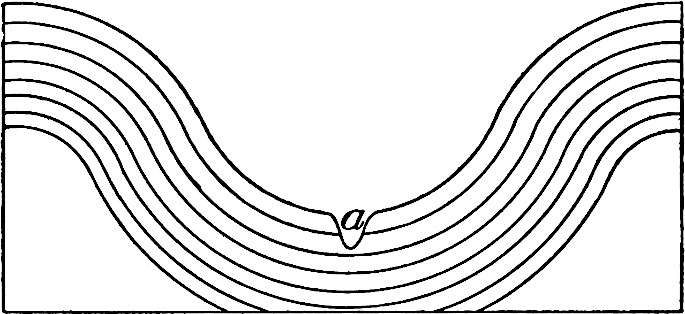
Fig.
58.—Structural valley with a river valley developing its bottom.
The foregoing illustrations by no means exhaust the list of conditions under which valleys develop, but they suffice for the present.
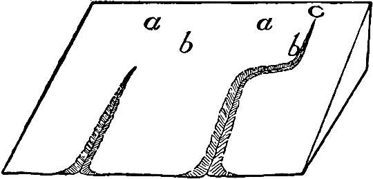
Fig.
59.
Fig.
60.
Figures to show why the head of a gully (and therefore a valley) departs from a direct course.
The courses of valleys.—River valleys are rarely straight. To understand why they are crooked it is only necessary to understand the methods by which they grow. In so far as a river valley is a gully grown big, that is, in so far as its length is the result of head erosion, its course was determined by the course of the antecedent gully. If in the case shown in Fig. 59 the slope of the surface above the head of the gully is uniform, its material homogeneous, and the rainfall everywhere equal, more water will come into the gully from the direction a than from any other. In this case there would be more wear in the direct line of its extension than elsewhere, and the head would advance in a straight line. But if there be inequalities of slope about the head of a gully at any stage of its development more water may come in from some direction other than that in the direct line of its extension. In Fig. 59, for example, more water may enter from the direction of b than from that of a. Since most wear is likely to be affected along the line of greatest inflow, the head of the gully will be turned in that direction (Fig. 60). Started in this course it will continue in the new direction so long as erosion in this line is greater than that elsewhere; but whenever the configuration of the surface causes more water to enter the head of the gully from some direction other than that in which it is headed, the line of axial growth is again changed, as toward c, Fig. 60. Since new land surfaces are probably more or less undulatory, crookedness should be the rule among valleys developed from gullies by head erosion. Streams and valleys the courses of which are determined by the original slope of the land are said to be consequent.
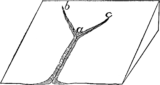
Fig.
61.—Diagram illustrating the development of two equal gullies from the head of one.
Inequalities of material, leading to unequal rates of erosion, effect the same result, in the absence of inequalities of slope. If at any stage of a valley’s development erosion were equal in two directions at its head, and at the same time greater than at points between, two gullies would result (Fig. 61) diverging from the point in question.
In the case of a valley developed by overflow from a lake its course is determined by the lowest line of flow to which the water has access. If this line be straight the valley will be straight; if it is crooked, as it generally is, the valley is crooked also.
The development of tributaries.—Thus far valleys leading immediately to the sea have been considered, and no account taken of tributaries. As a matter of fact most considerable valleys have numerous tributaries. It is now in order to inquire into their mode of development.
So soon as a gully is started, the water flowing into it from either side wears back the slopes. The least inequality of slope, or the least variation in the character of the material, is sufficient to make the lateral erosion unequal at different points, and unequal erosion in the slopes results in the development of tributary gullies. The oldest tributaries may be nearly as old as the main which they join, and from which they developed, for the possibilities of unequal side erosion exist as soon as a gully is opened. While the main gully is developing into a ravine, and the ravine into a valley, the tributary gullies are likewise developing into maturer stages. Tributary to a young valley, therefore, there may be gullies near its head, ravines in its middle course, and small valleys along its oldest portion. It is not to be understood, however, that the oldest tributaries are necessarily the largest, for because of more favorable conditions for growth the younger tributaries often outstrip the older.
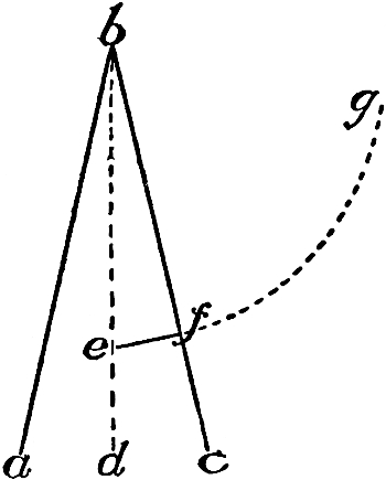
Fig.
62.—Diagram to illustrate the oblique position of a tributary gully at its inception, and its later normal change of direction.
The position of tributaries with reference to their mains is worthy of note. The water flowing down a slope follows the line of steepest descent. A gully is usually wider at its lower end, and narrower at its upper. Wherever this is true the line of steepest descent down its side is not a line perpendicular to its axis, but a line slightly oblique to it (ef, Fig. 62), and oblique in such a direction that it meets the axis with an obtuse angle below and an acute angle above. It is in the direction corresponding to this line that tributary gullies tend to develop. Thus at the inception of its history a tributary gully is likely to join its main with an angle slightly acute on the up-stream side. If the tributary did not begin until after its main was farther advanced this tendency would be less and less pronounced. Inequalities of material or slope would often counteract this tendency, which, at best, would cause the courses of tributaries to depart but little from perpendicularity to their mains.
After the head of a tributary has worked back from the immediate slope of its main every condition which determines the course of a gully is likely to affect it, and it is by no means certain that it will continue to lengthen in the direction in which it started. Since the general slope of the surface into which the tributary works is likely to be seaward, more water is likely to enter from the landward than from the seaward side of its head, so that, except where there are notable irregularities of slope, its tendency will be to turn more and more toward the direction of its main (efg, Fig. 62).
In depth the tributary is always limited by its main. The principles which determine the length and width of a main valley determine also the length and width of a tributary (see p. 67 et seq.).
A CYCLE OF EROSION. ITS STAGES.
From what has preceded it is clear that the topography of a region undergoing erosion will change greatly from time to time. The first effect of erosion is to roughen the surface by cutting out valleys, leaving ridges and hills. The final effect is to make it smooth again by cutting the ridges and hills down to the level of the valleys.
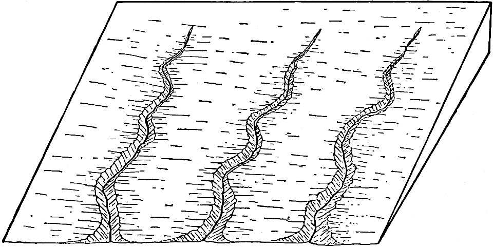
Fig.
63.—Diagram showing three parallel valleys in a land surface.

Fig.
64.—Diagram to illustrate the lowering of the surface by valley erosion. The successive cross profiles of the valleys are represented by the lines 1–1, 1–1′, 2–2, 2–2′, etc.
The base-level of erosion has already been defined; but the mode of its development may now be illustrated in the light of the preceding discussion. Suppose a land surface affected by a series of parallel young valleys without tributaries (Fig. 63). Between them there is a series of upland plateaus. The profile of the surface between two adjacent valleys is represented in section by the uppermost line in Fig. 64. As the valleys are widened from 1–1 and 1,′–1′, to 2–2 and 2′–2′, the intervening plateau is correspondingly narrowed. When the valleys have attained the form represented by 3–3 and 3′–3′, the intervening upland has been narrowed to a ridge, a, and the valley flats have become wide. With continued erosion the ridge will be lowered (to b and below), and in time the surface will approach a plain. In this condition it is known as a peneplain (an “almost-plain”). Finally, when running water has done its utmost, the ridges will be essentially obliterated and a base-leveled plain (e, e′, e″) results. The figure expresses the fact that the base-level develops laterally from the axis of the valley. It also develops headward from the seaward end of the valley. Similarly, taking into account all the valleys which affect it, the seaward margin of a base-leveled plain is developed first, and thence it extends itself inland.
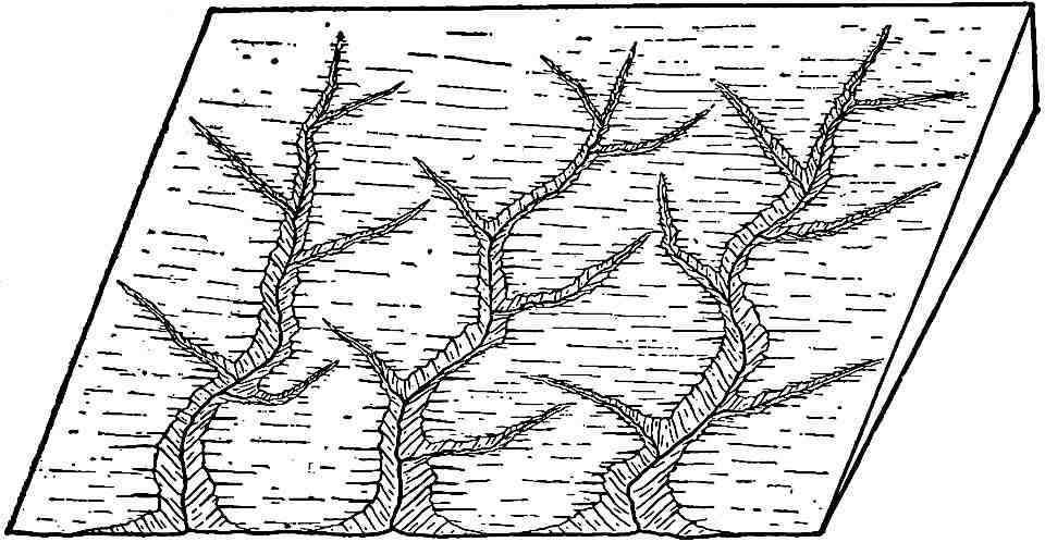
Fig.
65.—Diagram showing the dissection of the upland shown in
Fig.
64
by tributary valleys.
Tributaries are tolerably sure to develop along each main valley. The heads of the tributaries work back across the uplands between the main valleys, dissecting them into secondary ridges (Fig. 65). Tributaries will develop on the tributaries, and these tertiary valleys dissect the secondary ridges into those of a lower order. This process of tributary development goes on until drainage lines of the fourth, fifth, sixth, and higher orders are formed (Fig. 66). Since the process of valley development under such circumstances is also the process of ridge dissection, a stage is presently reached where the ridges are cut into such short sections that they cease to be ridges, and become hills instead. Even then the processes of erosion do not stop, for the rain-water falling on the hills washes the loose material from their surfaces, and starts it on its seaward journey. Thus the “everlasting hills” themselves are lowered, and, given time enough, will be carried to the sea. Under these conditions, as under those already discussed, the final result of stream erosion is the reduction of the land to base-level. The base-leveled surface, as before, would not be absolutely flat. The area reduced by each stream will have a slight gradient down-stream, and from each lateral divide toward the axis of the valley. The crests of the scarcely perceptible elevations which remain will be in the position of the former divides, and these will be highest where most distant from the sea by the course which this part of the drainage took. Even the insensible divides between streams flowing in a common direction may disappear, for when valleys have reached their limits in depth, their streams do not cease to cut laterally. Meandering in their flat-bottomed valleys, they often reach and undercut the divides (Pl. VII), whether they be high or low. By lateral planation, therefore, the divides between streams may be entirely eaten away.
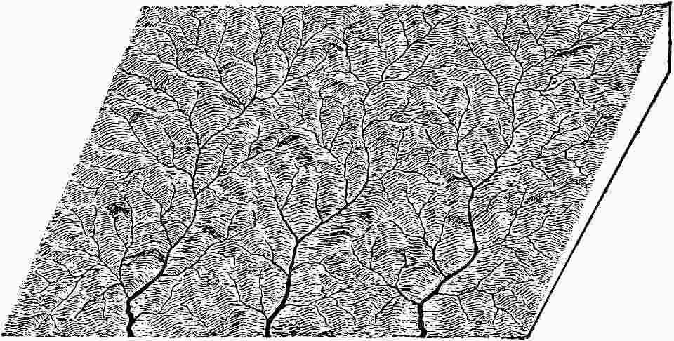
Fig.
66.—Diagram showing tributaries of several orders developed from the conditions sketched in the text.
It has now been seen that by whatever method erosion by running water proceeds, whether there be many valleys, or few or none, the final result of subaërial erosion must be the production of a base-level. It has also been seen that the base-level is first developed at the lower ends of the main streams, and that it extends itself systematically up the main valleys and up all tributaries. The time involved in the reduction of a land area to base-level is a cycle of erosion.
It will have been evident from the preceding pages that the terms “grade,” “graded plain,” and “base-level” and “base-leveled plain,” are somewhat variously, and therefore somewhat confusingly, used. “Grade is a condition of essential balance between corrasion and deposition.”[29] A graded valley is one in which deposition and corrasion are, in the vertical sense, balanced. Its angle of slope is most variable, and is dependent on the capacity of the stream for work, and on the work it has to do. A weak river must have a higher gradient than a strong one; a stream with much sediment must have a higher gradient than one with little, and a stream with a load of coarse material must have a higher gradient than one with a load of fine. Thus the graded valley of the lower Mississippi has an inappreciable angle of slope, but the graded valleys of many of its tributaries have slopes of hundreds of feet per mile. Since both the size of the stream and the amount and coarseness of its load at a given place vary from time to time, it is clear that the inclination of a graded valley must vary also, and further, that it must be in process of continual readjustment. With the changing conditions of advancing years the slope of a graded valley normally decreases. The same principles apply to graded surfaces outside of valleys.
In the continual readjustment of grades incident to a river’s normal history the land is brought nearer and nearer to sea-level without ceasing to be at grade. When the inclination of a graded surface becomes so low that it is sensibly flat, the surface may be said to be at base-level, although this does not mean that the surface can never be degraded further. If the term be used in this way, it is clear that there is no sharp line of distinction between a graded surface and a base-leveled surface, and as the terms are now commonly applied no such distinction exists.
If the term base-level were made synonymous with sea-level, as has been proposed,[30] the term might as well be discarded, for sea-level could always be used in its stead. Furthermore, streams often erode below sea-level. The bottom of the channel of the Mississippi is below sea-level for some 400 miles above its debouchure, and locally (Fort Jackson) it is nearly 250 feet below. This deep channel is the result of the erosive activity of the stream, not of subsidence. Again, the sea-level is itself inconstant. The extent of its changes cannot now be measured, but they have probably been more considerable in the course of geological history than has been commonly recognized. It is true that they take place slowly, as far as known, but it is also true that the duration of an erosion cycle is sufficiently long for even very slow changes to reach great magnitude. The sea-level, therefore, can hardly be accepted as the absolute base-level, unless (1) the absolute base-level is a variable, and unless (2) the absolute base-level be a surface below which rivers may cut to the extent of at least 250 feet.
The ocean may be looked upon as a barrier which in a general way limits the down-cutting of running water; for only very large streams cut much below its level. Other barriers, such as lakes, and the outcrops of hard rock in a stream’s bed, have a comparable, though more temporary, effect on the development of valley plains above. Plains thus developed have been called temporary base-levels. They differ from other graded plains in being controlled primarily by a barrier below, rather than by conditions which exist above.
Since river valleys have a beginning and pass through various stages of development before the country they drain is base-leveled, it is important to recognize their various stages of advancement. Nor is this difficult. An old valley and a young one have different characteristics, and the one would no more be mistaken for the other by those who have learned to interpret them, than the face of an aged man would be mistaken for that of a child.
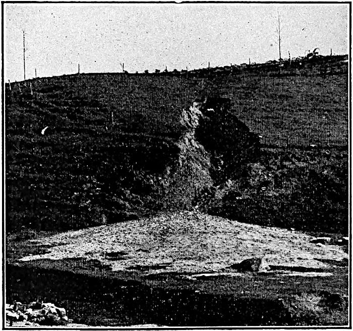
Fig.
67.—A gully developed by a single shower. (Blackwelder.)
The cycle begins with the beginning of valley development, and at that stage drainage is in its infancy. The type of the infant valley is the gully or ravine (Figs. 67 and 68). It has steep slopes and a narrow bottom. Fig. 1 of Plate IV represents similar, or rather older, ravines in contour (shore of Lake Michigan, just north of Chicago). With age, the valley widens, lengthens, and deepens, and passes from infancy to youth. In this stage also the valleys are relatively narrow, and the divides between them broad. They may be deep or shallow, according to the height of the land in which they are cut, and the fall of the water flowing through them; but in any case the streams flowing through them have done but a small part of the work they are to do before the country they drain is base-leveled. Figs. 69 and 70, respectively, represent youthful valleys in regions of moderate and great relief. Fig. 2, Plate IV, shows a youthful valley in a region of slight relief (near Casselton, N. D., Lat. 46° 40′, Long. 97° 25′). The uppermost line in Fig. 64 likewise represents topographic youth, as shown in cross-profile.
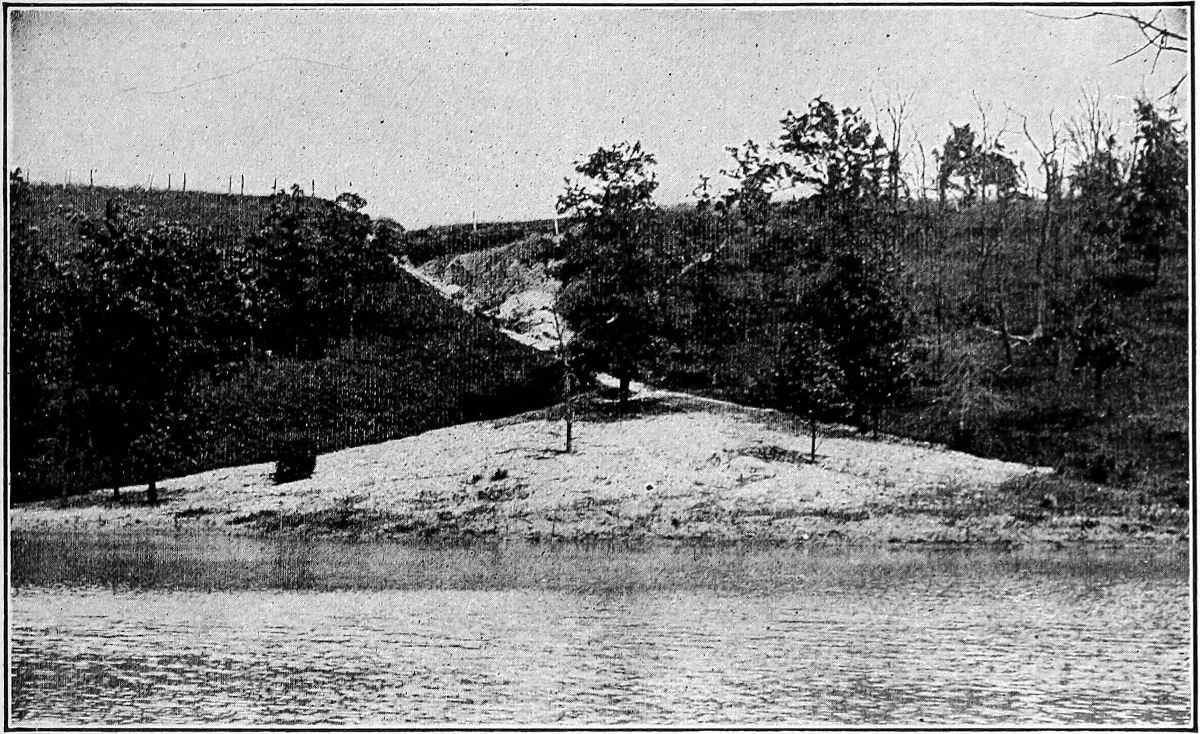
Fig.
68.—A gully somewhat older than that shown in
Fig.
67
. (Alden.)
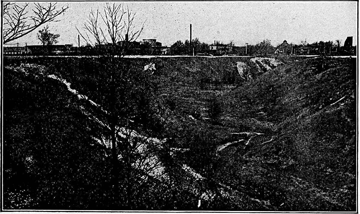
Fig.
69.—A young valley in a region of slight relief.
Not only are narrow valleys said to be young, but the territory affected by them is said to be in its topographic youth, since but a small part of the time necessary to reduce it to base-level has elapsed. An area is in its topographic youth when considerable portions of it are still unaffected by valleys. Thus the areas (as a whole), as well as the valleys, represented on Plate IV, are in their topographic youth. It is often convenient to recognize various sub-stages, such as early, middle, and late, within the youthful stage of valleys or topographies. The different parts of the areas shown on Plate IV, for example, represent different stages of youth.
Youthful streams, as well as youthful topographies, have their distinctive characteristics. They are usually swift; their cutting is mainly at the bottom rather than at the sides, and their courses are often marked by rapids and falls.
As valleys approach base-level they develop flats. As the valleys and their flats widen, and as their tributaries increase in numbers and size, a stage of erosion is presently reached where but little of the original upland surface remains. The country is largely reduced to slopes. In this condition the drainage and the topography which it has determined are said to be mature. Mature topography is shown in contours in the figures of Plate V, and in the northern part of Plate VI, where slopes, rather than upland or valley flats, predominate. Fig. 1 of Plate V represents an area in southeastern Kentucky (Lat. 37° 12′, Long. 83° 10′); Fig. 2, an area in western Virginia. Plate VI represents an area in southern California, somewhat west of San Bernardino. The three areas are alike in representing mature drainage, though not of equal stages of advancement. The striking differences of topography of the three areas are the result of differences in rock structure and altitude, and will be considered later. Mature topography is also shown in Fig. 71, where the relief is moderate, and in Figs. 72 and 73, where it is great. Figs. 72 and 73 illustrate clearly the universal tendency of rivers in regions of notable relief to develop new flats well below the old surface of the region. At the same time that these low-lying flats are developing, tributary drainage is dissecting and roughening the upper surfaces. This process is well shown in Fig. 73. In both Figs. 72 and 73 the summits of the mountains on either side of the valleys appear to have had about the same elevation. The new flat is therefore developed at the expense of the old flat. As will be seen in the sequel, the first flat which a stream develops along its course is usually somewhat above base-level. It is a graded flat.
PLATE V.
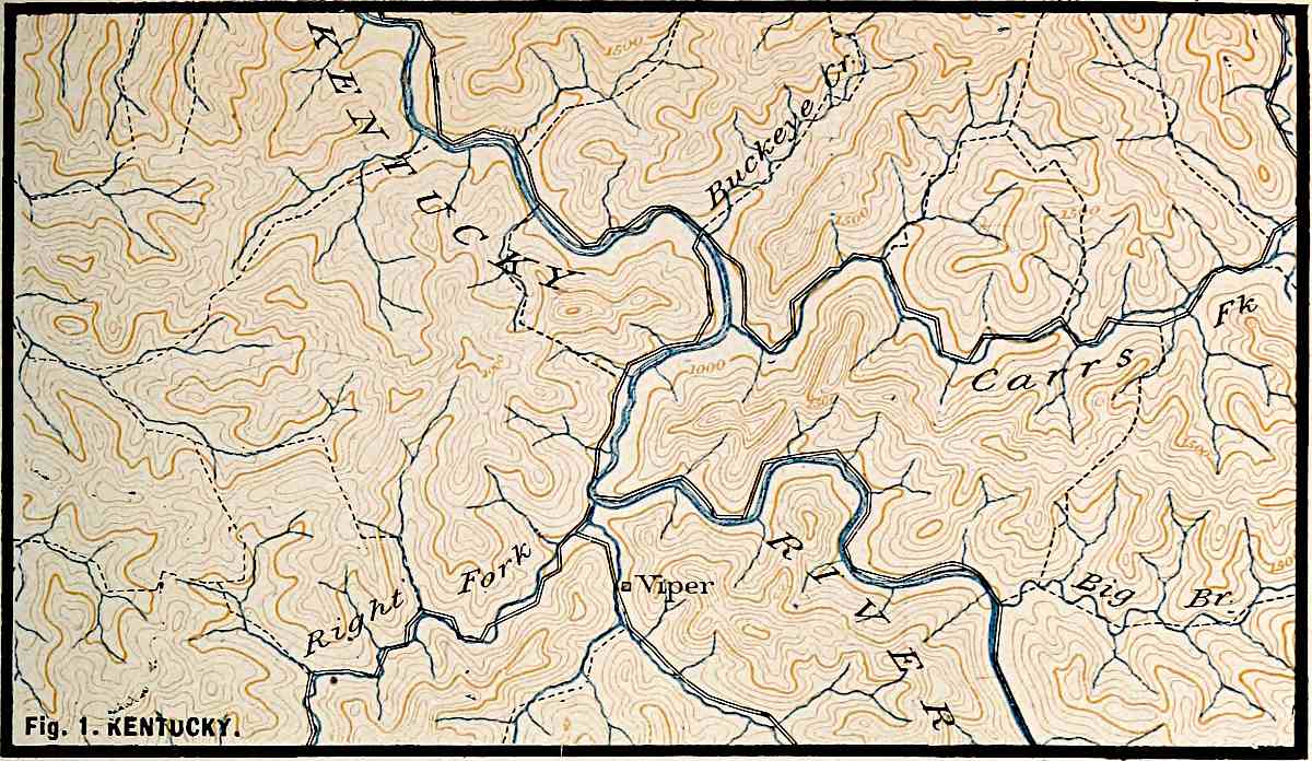
U. S. Geol. Surv.
Scale, 2+ mile per inch.
Fig.
1. KENTUCKY.
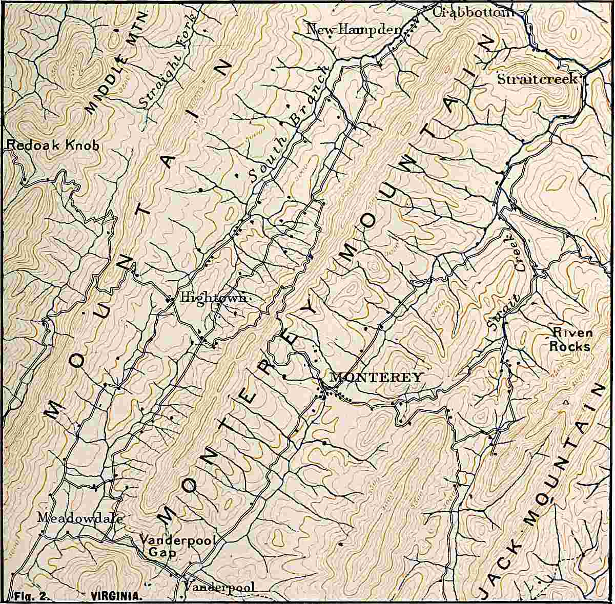
U. S. Geol. Surv.
Scale, 2+ mile per inch.
Fig.
2. VIRGINIA.
PLATE VI.
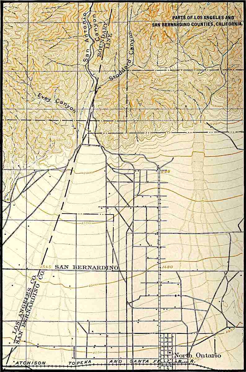
U. S. Geol. Surv.
Scale, 1+ mile per inch.
PARTS OF LOS ANGELES AND SAN BERNARDINO COUNTIES, CALIFORNIA.
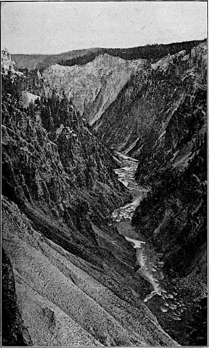
Fig.
70.—The valley (canyon) of the Yellowstone. A young valley in an elevated region.
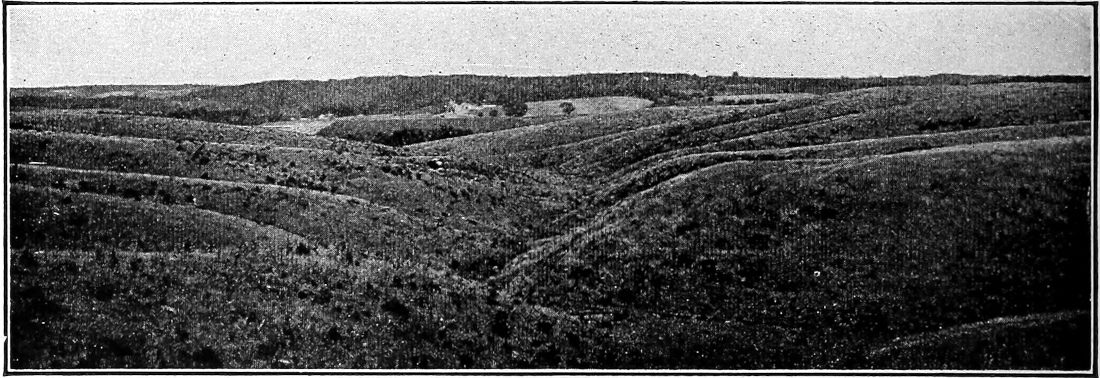
Fig.
71.—Mature erosion topography in a region of slight relief, Iowa. (Calvin.)
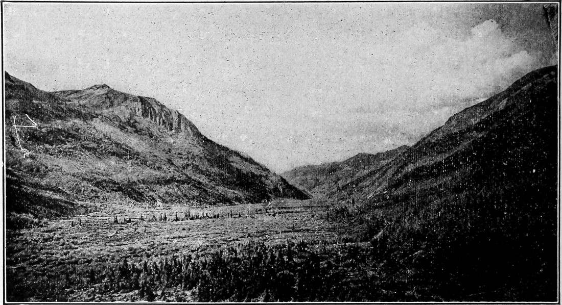
Fig.
72.—Mature erosion in a mountain region. From mouth of Gray Copper Gulch, Silverton,
Colo.
, quadrangle. (Cross,
U. S. Geol. Surv.
)
The same processes which have made young valleys mature will in time work further changes. When the gradients of the valleys have become low and their bottoms wide, and when the intervening ridges and hills have become narrow and small, the drainage and the drainage topography have reached old age, and the streams are in a condition of senility. This is illustrated by Fig. 1, Plate VII (central Kansas), and in section by the third and lower lines in Fig. 64. Topographic old age sometimes has a different expression; this is shown in Fig. 74, where most of the surface has been brought low. The elevations which rise above the general plain are small in area, but have abrupt slopes. This phase of old-age topography is usually the result of the unequal resistance of the rock degraded. The effects of unequal rock-resistance will be considered later.
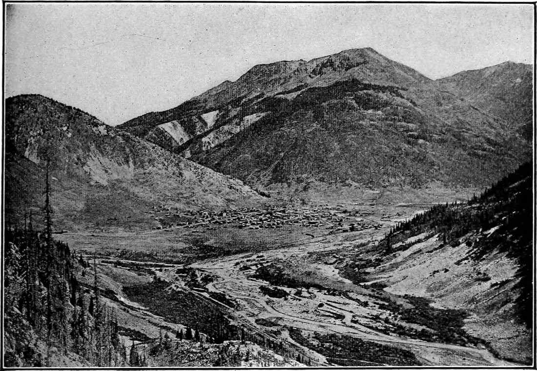
Fig.
73.—Mature erosion in a mountain region. Silverton,
Colo.
(Cross,
U. S. Geol. Surv.
)
The marks of old streams are as characteristic as those of young ones. They have low gradients and are sluggish. Instead of lowering their channels steadily they cut them down in flood, and fill them up when their currents are not swollen. They meander widely in their flat-bottomed valleys (Fig. 1, Pl. VII, Central Kansas) and their erosion, except in time of flood, is largely lateral.
If the processes of degradation were to continue until the land surface was brought to sea-level, and this might be done by solution though not by mechanical erosion of running water, the rivers would no longer flow, and the drainage system would have reached the end of its history—death.
Not only do valleys normally pass from birth to youth, from youth to maturity, and from maturity to old age, but a single river system may show these various stages of development in its various parts. Thus in the area shown in Fig. 2, Plate VII (north central Kansas), there is a tract (extreme southwest) where the erosion history is scarcely begun. The zone of land a little farther northeast, and just reached by the heads of the valleys (same figure), is in its youth. The well-drained and uneven tract southwest of the flat of the Solomon River is in maturity, while the flat of the main valley has the general characteristics of old age.
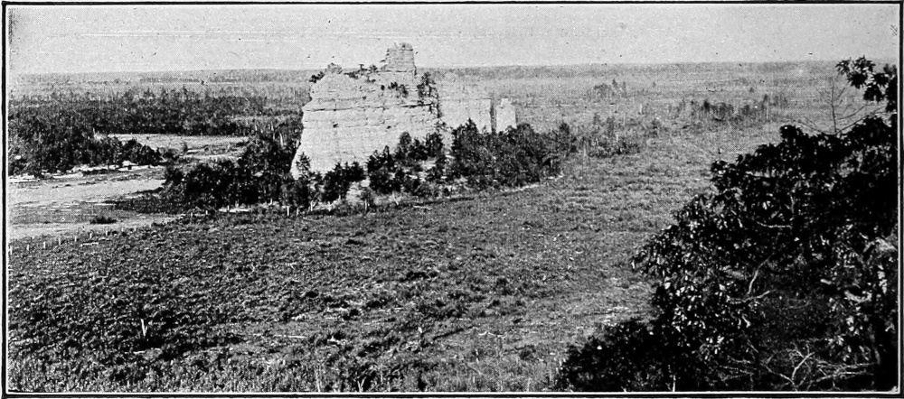
Fig.
74.—A peneplained surface where the elevations are small but steep-sided. Near Camp Douglas,
Wis.
(Atwood.)
The age of valleys in terms of erosion is also expressed more or less perfectly by their cross-sections. The line 1–1 (and 1′–1′) of Fig. 64 represents in cross-section a narrow V-shaped valley. Such a section is always indicative of youth. The stream which developed it cut chiefly at its bottom, not at its sides. It was therefore rapid, and rapid streams are young. The line 2–2, (2′–2′) (Fig. 64) shows the same valley at a later and maturer stage when downward cutting has nearly ceased. The widening of the valley by slope wash has become relatively more important than before, and the stream has so far lost velocity as the result of diminished gradient as to be unable to carry away all the detritus washed down from the sides. As a result of deposition at the bases of the side slopes, a concave curve has been developed. Up the valley from the point where such a section as is represented by 2–2 occurs, the valley may still have a section similar to that represented by 1–1.
PLATE VII.
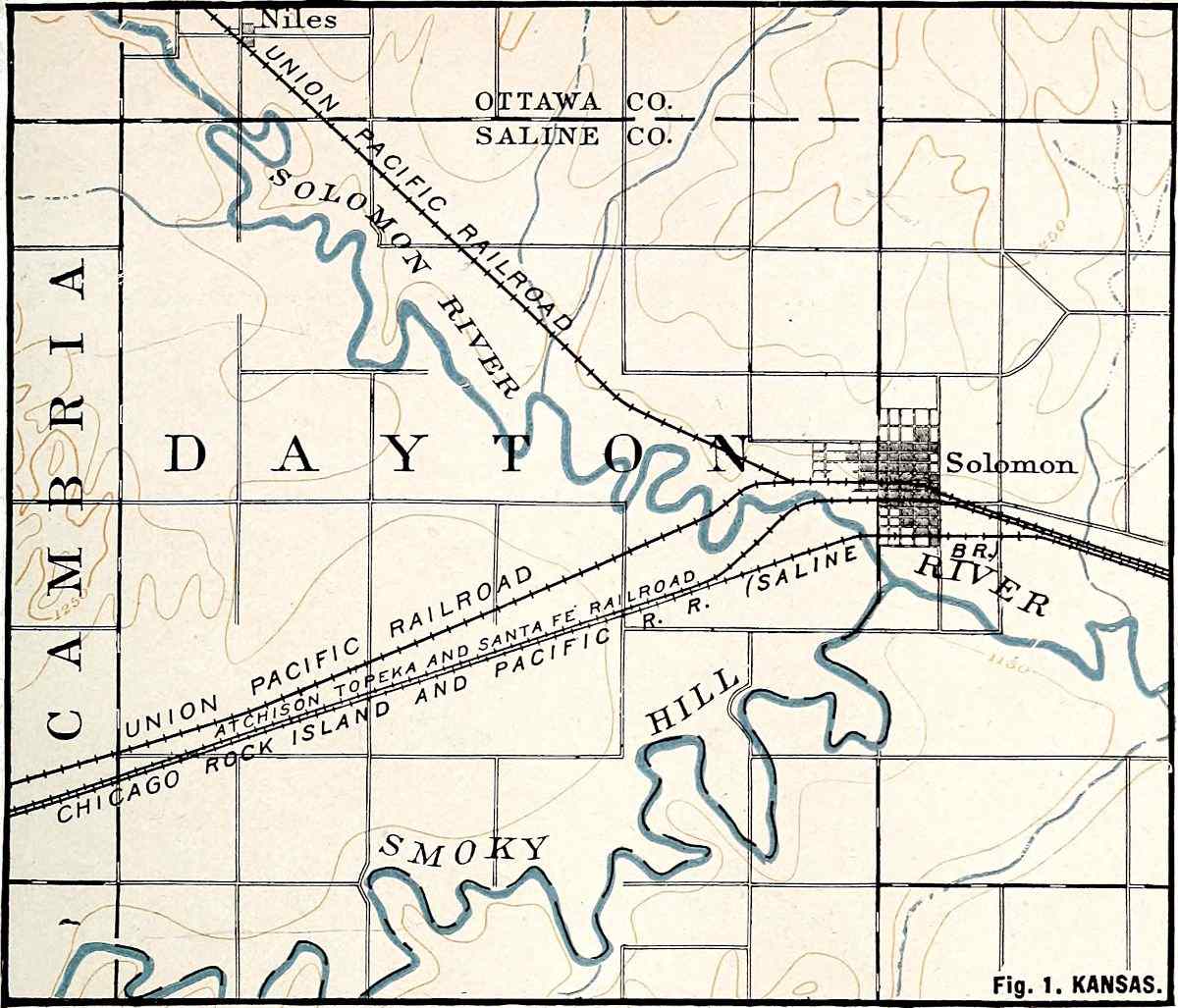
U. S. Geol. Surv.
Scale, 2+ mile per inch.
Fig.
1. KANSAS.
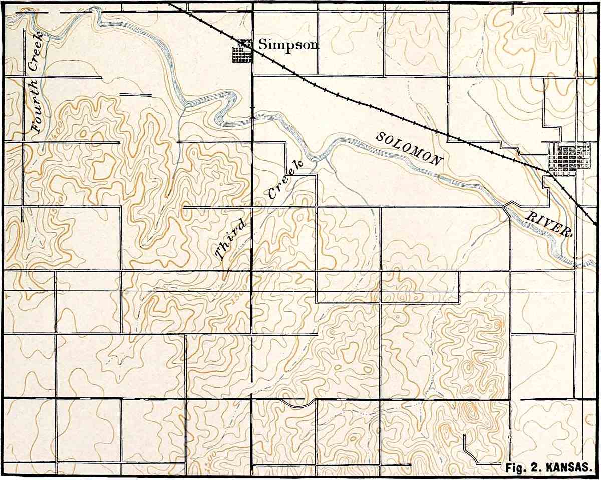
U. S. Geol. Surv.
Scale, 2+ mile per inch.
Fig.
2. KANSAS.
PLATE VIII.
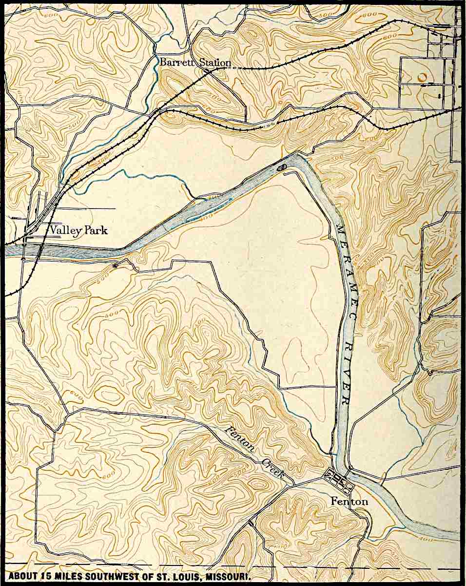
U. S. Geol. Surv.
Scale, 1+ mile per inch.
ABOUT 15 MILES SOUTHWEST OF ST. LOUIS, MISSOURI.
Still later stages of development are represented by the cross-sections 3–3 and 4–4. Not only has the valley become larger, but the stream has deposited detritus (not shown in the figure) in the bottom of its valley, developing an alluvial flat. On this flat the stream meanders, and the valley may be widened by the undercutting of the bluffs wherever the stream in its wanderings reaches them (Pl. VIII, near St. Louis). A valley might possess the characteristics shown by the cross-sections 3–3, 2–2, and 1–1, Fig. 64, in its lower, middle, and upper courses, respectively.
The preceding discussion, and the illustrations which accompany it, give some idea of the topography which characterizes an area in various stages of its erosion history. Whether the valleys are deep or shallow, and the intervening ridges high or low, depends on the original height of the land and its distance from the sea. The higher the land, and the nearer it is to the sea, the greater the relief developed by erosion. A plateau near the sea may become mountainous in the mature stage of its erosion history, while a plain in the same situation would only become hilly. A plateau in the heart of a continent would have less relief in its maturity than one of equal elevation near the sea, since the grade-plain in the former position is higher than in the latter. Plates IV and IX show youthful topography where the relief is relatively slight, and Plate X shows youthful topography where the relief is great. Similarly, Plates V and VI show mature topography where the relief is great, and Fig. 1, Plate III, shows mature topography where the relief is relatively slight.
Topographic youth, topographic maturity, and topographic old age are also indicated in other ways, and especially by the presence of features which rivers tend to destroy. If, for example, the surface of the land, well above the valley bottoms, is marked by numerous ponds and marshes, it is clear that drainage has not yet progressed beyond its early stages, for, unless the lakes be very deep, valleys working back into the land will find and drain them before topographic maturity has been reached. Their presence is evidence that the region where they occur has not yet been thoroughly dissected by erosion lines, and therefore has not reached maturity. Still other marks of topographic youth, such as rapids, falls, etc., as well as marks of topographic maturity and old age, will be mentioned in the following pages.
GENERAL CHARACTERISTICS OF TOPOGRAPHIES DEVELOPED BY RIVER EROSION.
With the characteristics of river valleys and the methods by which they grow clearly in mind it is easy to say whether rivers have been the chief agents in the development of a given topography. River valleys are distinguished from other depressions on land surfaces by their linear form and, leaving out of consideration the relatively insignificant inequalities in a stream’s channel, by the fact that any point in the bottom of a river valley is lower than any other point farther up the stream in the same valley, and higher than any point farther down the stream. The second point might be otherwise stated by saying that every valley excavated by erosion leads to a lower valley, or to the sea, or an inland basin. Streams which dry up, or otherwise disappear as they flow, constitute partial exceptions. If, therefore, the depressions on a land surface are linear, lead to other and deeper valleys, and finally to an inland basin, or the sea, and if the elevations between these valleys are such as might have been left by the excavation of the valleys, it is generally clear that rain and rivers have been the chief factors in the development of the topography. If, on the other hand, a surface is characterized by topographic features which streams cannot develop, such as enclosed depressions, or hills and ridges whose arrangement is independent of drainage lines, other agents besides rain and surface streams have been concerned in its development.
SPECIAL FEATURES RESULTING FROM SPECIAL CONDITIONS OF EROSION.
Many striking topographic and scenic features result from rain and river erosion. Some of them depend primarily on the conditions of erosion, such as climate, altitude, etc., while others depend largely on the structure and resistance of the rock. Between these two classes there is no sharp line of demarkation. Illustrations of two types, dependent largely but by no means wholly on conditions independent of the rock, are cited at this point. Others will be mentioned in other connections.
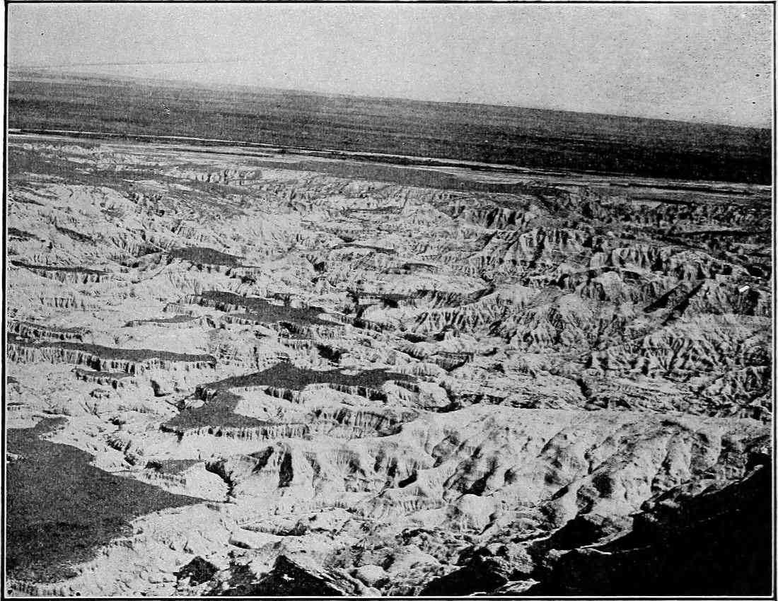
Fig.
75.—Bad-land topography. North of Scott’s Bluff, Neb. (Darton,
U. S. Geol. Surv.
)
Bad-land topography.—To a type of topography developed in early maturity in certain high regions where the rock is but slightly, though unequally, resistant, a special name is sometimes given. Such regions are termed bad lands. Some idea of bad-land topography is gained from Figs. 75 to 78. Bad-land topography is found in various localities in the West, but especially in western Nebraska and Wyoming, and the western parts of the Dakotas. The formations here are often beds of sandstone or shale, alternating with unindurated beds of clay. Climatic factors are also concerned in the development of bad-land topography. A semi-arid climate, where the precipitation is much concentrated, seems to be most favorable for its development. The bad-land topography is most striking in early maturity.
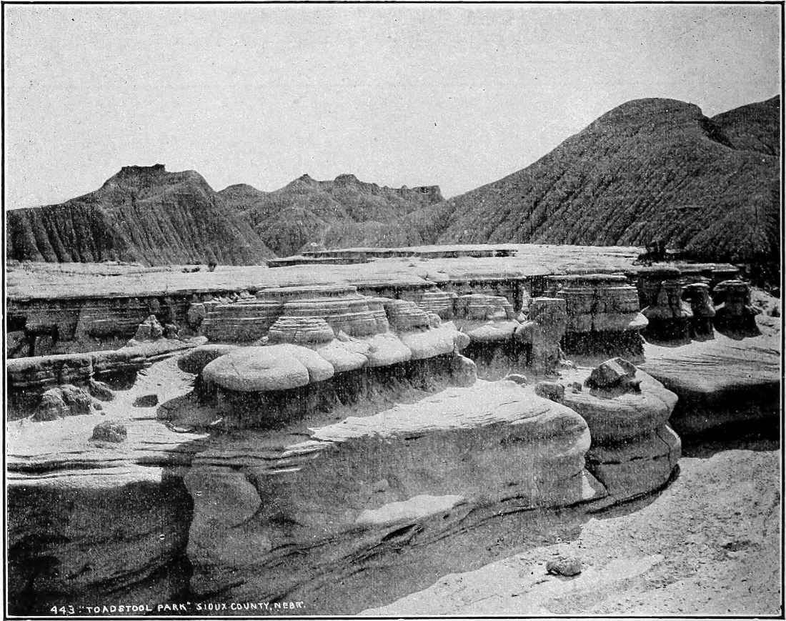
Fig.
76.—Toadstool Park, Sioux
Co.
, Neb. The peculiar topography is the result of erosion working on jointed rocks of unequal hardness in an arid region of considerable elevation where rainfall is unequally distributed. (Darton,
U. S. Geol. Surv.
)
Special forms of valleys; canyons.—Various conditions influence the size and shape of valleys, especially in the early stage of their development. If the altitude of the land be great, the gradient of the streams at this stage will be high. A high gradient means a swift stream, and a swift stream erodes chiefly at its bottom. High altitudes therefore favor the development of deep valleys. Such valleys will be narrow if the conditions which determine widening are absent or unfavorable. Since slope wash is one of the main factors in the widening of valleys, an arid climate favors the development of narrow valleys, if there be sufficient water to maintain a vigorous stream. Narrowness and steepness of slopes will also be favored if the valley is cut in rock which is capable of standing with steep faces. Thus a stream may develop a narrow valley in indurated rock where it would not do so in loose gravel, and, other things being equal, it will develop a narrower valley in rock which is horizontally bedded than in rock the beds of which are inclined. Aridity, high altitude, and the proper sort of rock structure therefore favor the development of canyons, and many of the young valleys in the western part of the United States where these conditions prevail, belong to this class.
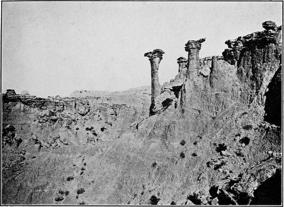
Fig.
77.—Detail of bad-land topography. Head of Indian Draw, Washington
Co.
,
S. D.
Protoceras sandstone on Oreodon clay. (Darton,
U. S. Geol. Surv.
)
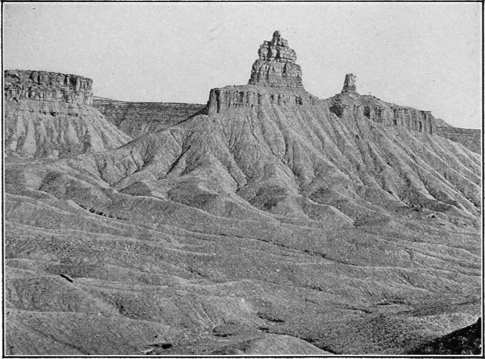
Fig.
78.—Detail of bad-land topography. Southwest foot of Mesa Verde,
Colo.
(Matthes,
U. S. Geol. Surv.
)
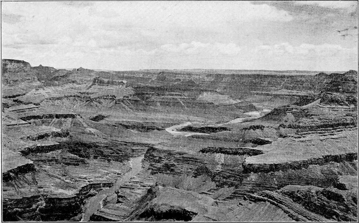
Fig.
79.—Grand Canyon of the Colorado. (Peabody.)
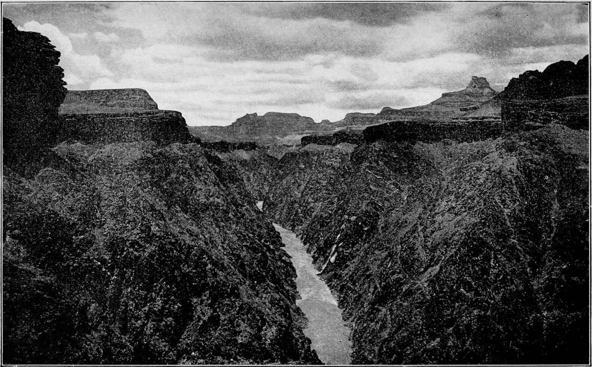
Fig.
80.—Grand Canyon of the Colorado. (Peabody.)

Fig.
81.—Diagram showing the relations of depth and width of a valley, the width of which is eight times the depth.
While all canyons are valleys, most valleys are not canyons. The distinction between a canyon and a valley which is not a canyon is not sharp. The canyon depends for its distinctive character on the relation of depth, width, and angle of slope to one another; but any definition of the depth, width, and angle of slope necessary to constitute a valley a canyon is arbitrary.[31] In popular usage the rule seems to be that if a valley is sufficiently deep, narrow, and steep-sided to be distinctly striking, it is called a canyon in regions where that term is in use. Whether a valley is deep, narrow, and steep-sided enough to be striking clearly depends on the observer. The Colorado Canyon (Figs. 79 and 80) is the greatest canyon known, but it is rarely more than a mile deep, and where its depth approaches this figure it is often eight, ten, or even twelve miles wide from rim to rim. Its width at bottom is little more than the width of the stream; that is, a few hundred feet. Its cross-profile throughout much of its course is therefore not in keeping with the conventional idea of a canyon. With a depth of one mile and a width of eight, the slope, if uniform, would have an angle of less than 15°. Such a valley is represented in Fig. 81. As a matter of fact the slopes of a canyon are not commonly uniform. The slopes represented in Fig. 82 correspond more nearly than those of Fig. 81, to the actual slopes of the Colorado Canyon. The inequalities of slope are occasioned by the inequalities of hardness. It is perhaps needless to say that to an observer on the rim of the canyon the slopes seem several times as steep as those shown in the diagrams.
Like all valleys which are narrow relative to their depth, the Colorado Canyon, great as it is, is a young valley; for it represents but a small part of the work which the stream must do to bring its drainage basin to base-level.
While aridity and altitude are conditions which favor the development of canyons, as shown by the fact that most canyons are high and dry regions, they are not indispensable. Niagara River has a canyon below its falls (Pl. IX), and the surrounding region is neither high nor arid. The narrow part of the valley has been developed by the recession of the falls, and is so young that side erosion has not yet widened the valley or lowered its angle of slope to such an extent as to destroy its canyon character. This canyon is often called a gorge, a term frequently applied to small valleys of the canyon type.

Fig.
82.—Cross-section of the Colorado Canyon. (After Gilbert and Brigham.)
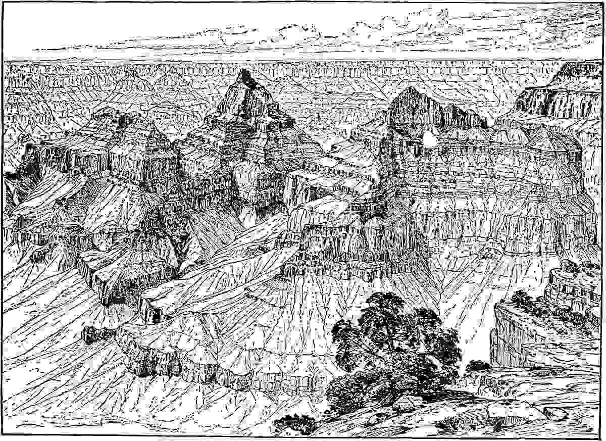
Fig.
83.—Detail of erosion in the Grand Canyon. The inequalities of slope are the result of unequal hardness. The vertical planes which give the architectural effect are the result of joints. (Holmes.)
Plate X shows portions of the canyons of the Yellowstone and the Colorado rivers respectively. In the first the contour interval is 100 feet, and in the second, 250 feet. The horizontal scale is ¹⁄₁₂₅₀₀₀ (about 2 miles to the inch) in the first, and ¹⁄₂₅₀₀₀₀ in the second. These scales should be borne in mind in interpreting the map.
Falls, rapids, narrows, and other peculiar features, due primarily to inequalities in the hardness of the rock affected by erosion, will be considered later.
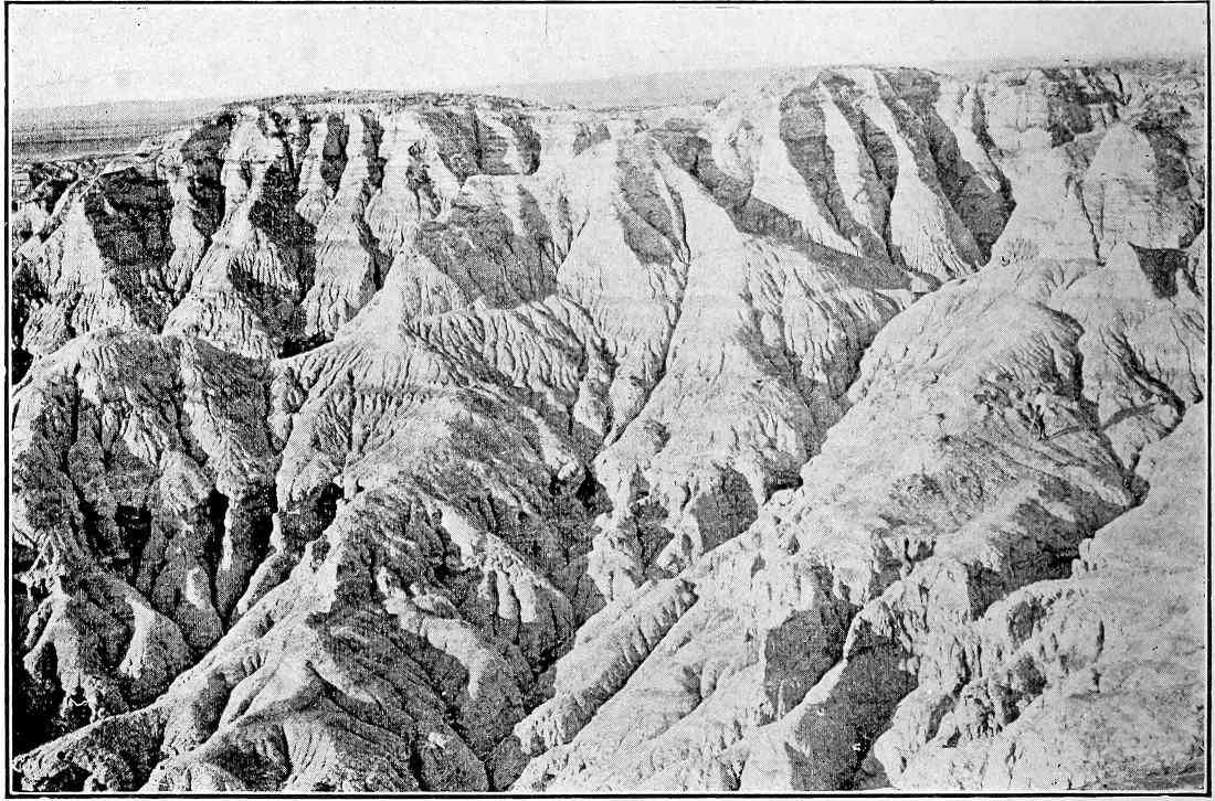
Fig.
84.—A surface illustrating the struggle for existence among gullies. Most of the smaller gullies shown on the slope can have but little growth before being absorbed by their larger neighbors. A type of erosion surface common in the Bad Lands. Scott’s Bluff, Neb. (Darton,
U. S. Geol. Surv.
)
THE STRUGGLE FOR EXISTENCE AMONG VALLEYS AND STREAMS.
It is not to be inferred that every gully becomes a valley, nor that every small valley becomes a large one. Among valleys, as among living things, there is a struggle for existence, and fitness determines growth and survival. At an early stage of its erosion history the number of small valleys in a given area is often great, while at a later stage the number is less and the size of the survivors greater.
PLATE IX.
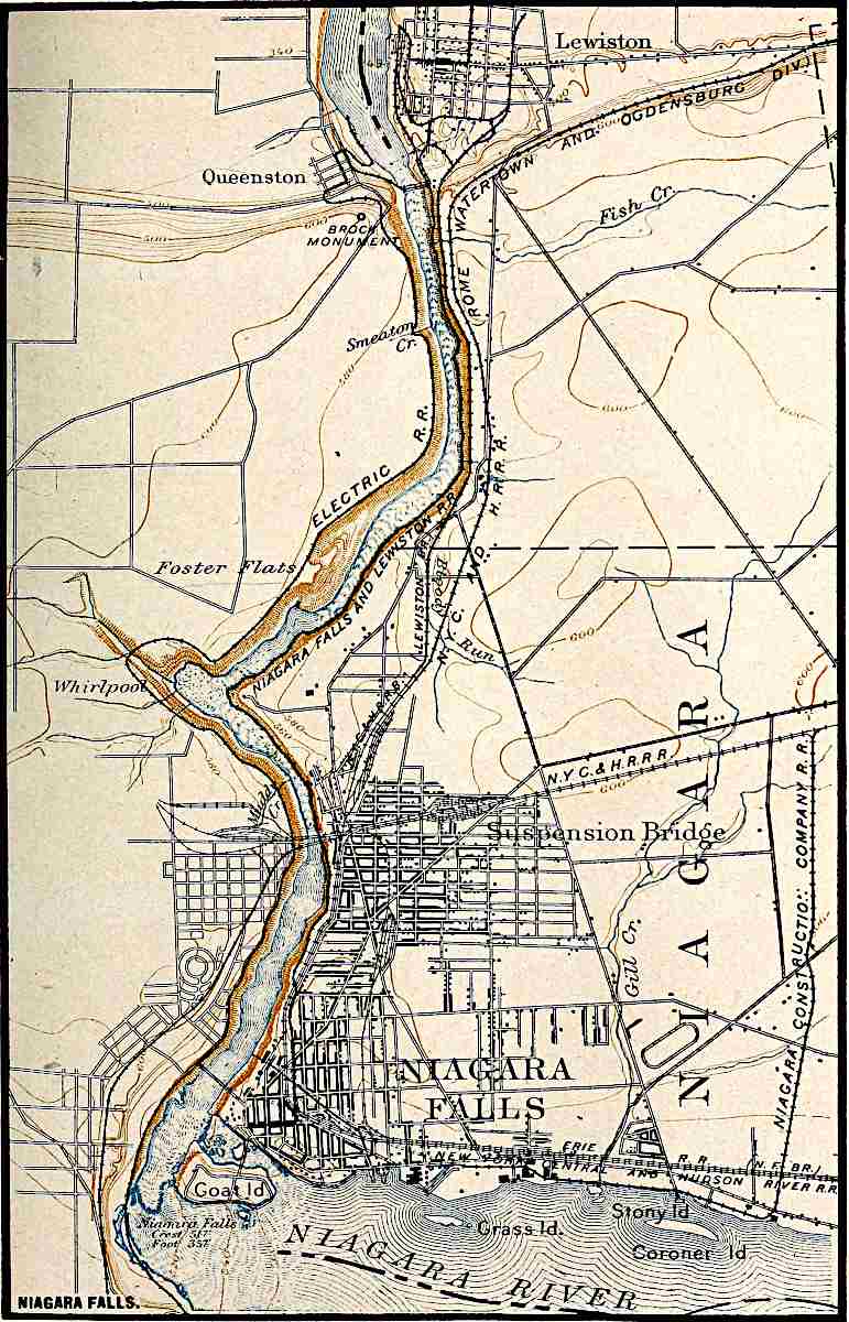
U. S. Geol. Surv.
Scale, 1+ mile per inch.
NIAGARA FALLS.
PLATE X.
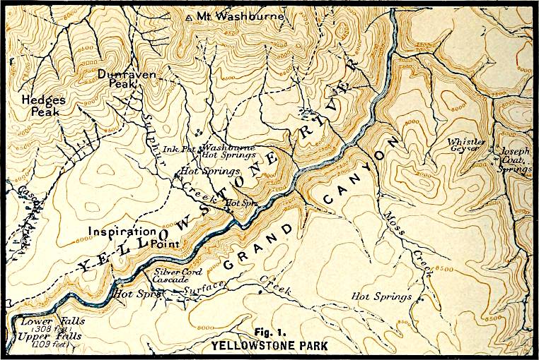
U. S. Geol. Surv.
Scale, 2+ mile per inch.
Fig.
1. YELLOWSTONE PARK.
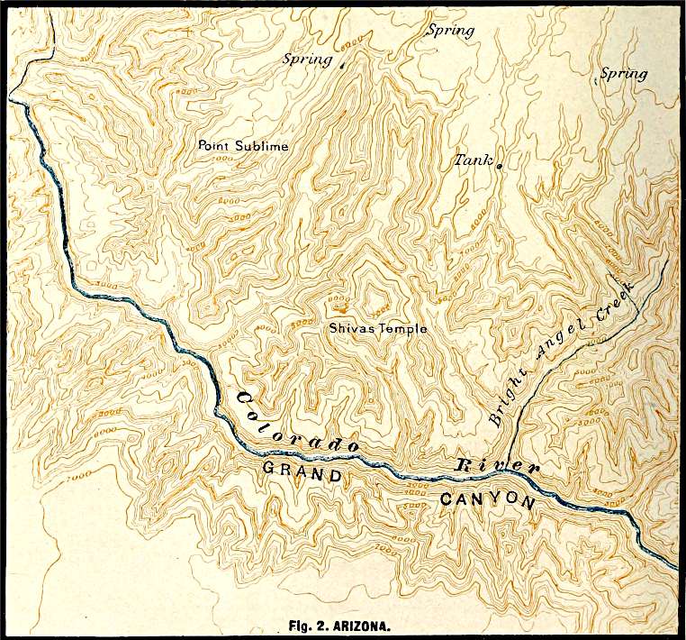
U. S. Geol. Surv.
Scale, 2+ mile per inch.
Fig.
2. ARIZONA.
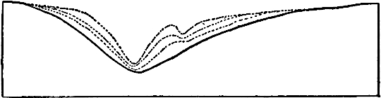
Fig.
85.—Diagram illustrating the absorption of one gully by another by lateral erosion. The successive lines represent successive cross-sections.
One phase of the struggle for existence is often well illustrated on a freshly exposed slope of clay. The number of miniature gullies which develop on such a slope, even in a single shower, may be very large (Fig. 84); but the history of many of them is ephemeral. If two adjacent ones are of unequal depth the widening of the deeper narrows and finally eliminates the divide between them, and the two become one (Fig. 85).
Another phase of the struggle for existence is shown in other situations. Examination of a good map of the north shore of Lake Superior or the west shore of Lake Michigan shows a large number of small streams and gullies (Fig. 1, Pl. IV). The valleys are short and narrow, and between and beyond them are considerable areas untouched by erosion. The drainage near the lake is therefore young, and each of the small valleys is growing. This condition of things is perhaps typical of that which has been, is, or will be along the average coast at a certain stage in its erosion history. No equal stretch of coast-line where erosion is far advanced can boast of a number of large rivers comparable to that of the many small ones along the coasts mentioned. It therefore seems evident that of these many small streams a few only will attain considerable size.
Some of the methods by which the growth of the many is arrested are easily understood. Some of the young valleys on a given coast will work their heads back into the land faster than others because of inequalities of slope and material. This will be true of the tributaries no less than of their mains. If valleys develop in ways other than by head erosion (see p. 73) the chances are also against their equality of growth. If two streams, such as a and c, Fig. 86, develop faster than the intermediate stream b, it is clear that their tributaries may work back into the territory which at the outset drained into b, so as to cut off the supply of water from the latter stream (compare a′b′c′, Fig. 87). As a result, the growth of b will be checked, and ultimately stopped. Similarly other valleys, such as f, will get the better of their neighbors, and many of the competitors, as b, d, e, and g will soon drop out of the race. Between the stronger streams competition still goes on. If a′ and f′ develop faster than c′ its prospective drainage territory will be preëmpted by its rivals (compare Figs. 87 and 88). Thus as the result of the unequal rate at which valleys are lengthened, the larger number of those which come into existence are arrested in their development. As a result of growth in the manner indicated, the basins of even the large streams remain narrow at their lower ends while they expand above. This is the usual form of a drainage basin the development of which has been normal.
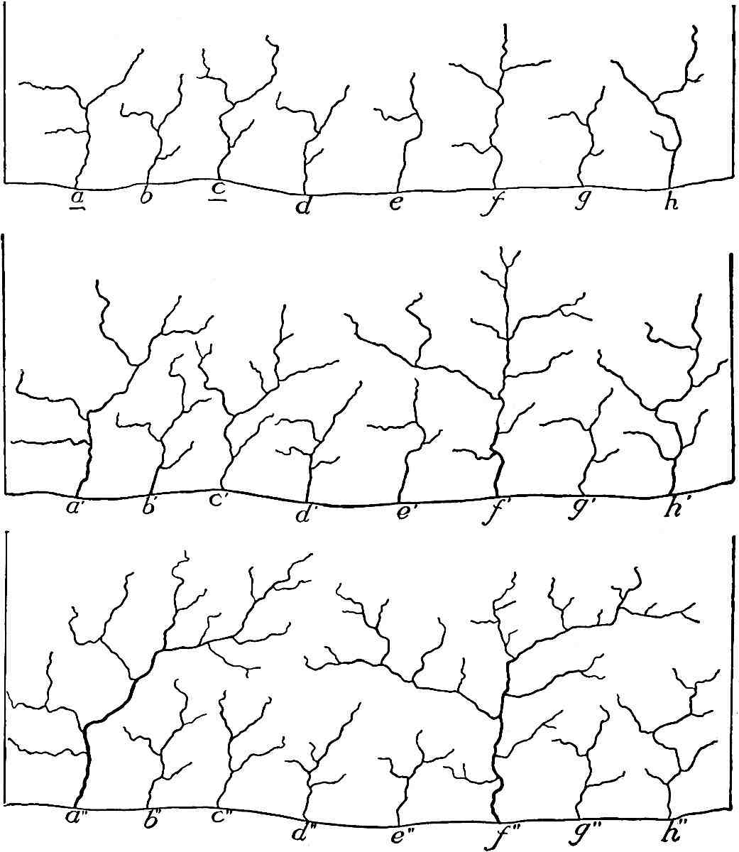
Fig.
86–88.—Diagrams to illustrate successive stages in the struggle for existence and dominion among streams.
Did valleys grow in length only, competition would not destroy the small ones; it would simply limit them. But valleys widen as well as lengthen, and by widening, adjacent valleys may eliminate the divide between them and become one. The elimination of the intervening ridge may be by lateral planation (p. 82), or, if the valleys be of unequal depth, by slope wash (see Fig. 85). By these and other processes many young valleys are dwarfed, and many others are destroyed.
Piracy.—Streams do not always hold the courses which they establish for themselves at the outset. If the valley occupied by the stream a, Fig. 89, is deepened more rapidly than the valley occupied by b, a tributary from the former, c, may work back across the inter-stream area to e and steal the head waters of that stream (Fig. 90). The tributary which does the stealing is known as a pirate. Stream f (Fig. 90) is said to be beheaded, and its upper portion, de, diverted. The beheaded stream is diminished in volume; or if its total supply of water came in above the point of tapping it would disappear altogether.
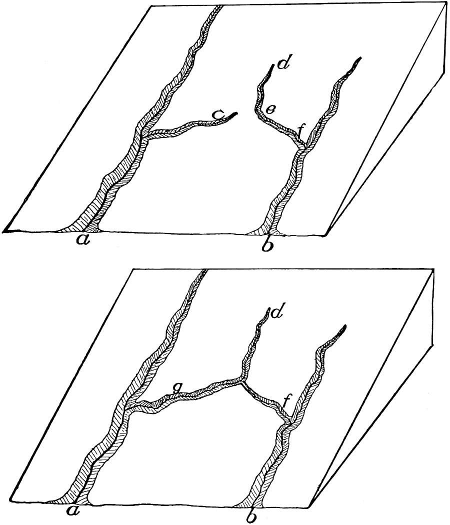
Fig.
89 and 90.—Diagrams to illustrate piracy.
The process may not end even here. If after the diversion of de the point in the channel to the left is lowered faster than the channel of the beheaded stream f, the divide between dg and the head of f (Fig. 90) will be shifted down the valley of the latter, as shown in Fig. 91. The shifting will go on until the divide reaches a position of stability, that is, until erosion on its opposite sides is equal.
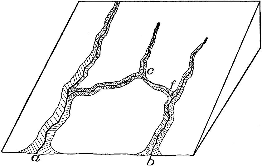
Fig.
91.—Diagram showing the shifting of a divide after piracy.
The foregoing case may be called foreign piracy because the valleys of different systems are concerned. Domestic piracy may also take place, as illustrated in the accompanying diagrams (Figs. 92 and 93). Here a tributary to a crooked river may develop, working back until it taps the main at a higher point, thus straightening the course of the stream. The change takes place only when the highest point in the tributary valley is brought below the surface of the water in the main stream at the point where the tapping takes place. This would be likely to occur only after the main stream had attained a low gradient, for so long as it is deepening its channel notably, the small amount of water flowing through the tributary valley would not be likely to bring it down to the level of the main. In any case the flow of water from the main stream through the new valley would be likely to be started during flood, and at such time the erosion in the new channel would be great. The complete and final diversion of the stream through the new channel might be a slow process.
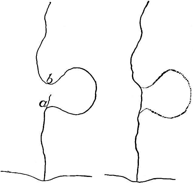
Fig.
92 and 93.—Domestic piracy. The tributary,
a
of
Fig.
92, develops headward until it taps the main stream at
b
, giving the result shown in
Fig.
93.
Piracy may occur where the material in which the valleys are cut is homogeneous; but, as will be seen later, heterogeneity of material, by determining unequal rates of erosion, stimulates the piratical proclivities of streams.
An actual case of piracy is shown on Plate XI. North and South Lakes formerly drained westward to the Schoharie Creek, the present head of which is in the extreme northwest corner of the map. The head of Kaaterskill Creek, which had a much higher gradient, worked back and captured the head of the westward-flowing stream, diverting the drainage from North and South Lakes to itself. Schoharie Creek was thus beheaded.
Plaatekill Creek, near the south limit of the map, appears to have beheaded the creek flowing west and northwest, similarly diverting its head waters. The Dells, Wis., quadrangle (U. S. Geol. Surv.) affords an illustration of domestic piracy.
RATE OF DEGRADATION.
The amount of mechanical sediment which the Mississippi River carries to the Gulf of Mexico is estimated to represent a rate of degradation for the Mississippi basin of about one foot in 5000 years. But the mechanical sediment carried to the Gulf does not really represent the total degradation of the basin, for the water which sinks beneath the surface is dissolving more or less rock substance, especially lime carbonate. This material is carried to the sea in solution, and does not appear in the sediment on which the above estimate is based. Taking into account the matter dissolved by the water and carried to the sea in solution, the average rate of degradation for the Mississippi basin is estimated at one foot in 3000 to 4000 years.
It is not to be inferred that this rate is uniform, or even that erosion at any rate whatsoever is taking place in all parts of the basin. Such is not the fact. On the whole the rate of erosion is doubtless greatest toward the margins of the basins where the land is in its topographic youth or early maturity. It is notably less in the middle courses of the valleys, and erosion is locally exceeded by deposition along the lower courses of the Mississippi and some of its main tributaries.
The average elevation of North America is not accurately known, but it is probably not far from 2000 feet. If the present rate of degradation, say one foot in 3500 years, were to continue, it would take something like 7,000,000 years to bring the continent to sea-level. But this rate of degradation could not continue to the end, for as the continent became lower streams would become sluggish and erosion less rapid. Long before the continent reached base-level the rate of degradation, so far as dependent on mechanical erosion, would become so slow that the time necessary to bring the continent to sea-level would be almost inconceivably prolonged. Furthermore, it is quite possible that the land is suffering, or is liable to suffer, uplift, relative or absolute. If the rate of rise were equal to the rate of degradation the average height of the continent would of course not be affected.
The amount of sediment carried by streams in suspension varies notably according to the stage of the water. During a year when the stream was under careful study the Mississippi at Carrollton (Miss.) was found to carry ¹⁄₆₈₁ of its weight of sediment during the high-water stage of June, and ¹⁄₆₃₈₃ during the low-water of October, the average for the year being ¹⁄₁₈₀₈. The average of a greater number of records gives about ¹⁄₁₅₀₀ as the average ratio between the weight of the sediment and the weight of the water. This corresponds to about ¹⁄₂₉₀₀ by volume, the average specific gravity being about 1.9. The amount of material carried in the upper part of the water was notably less than that carried at greater depths, but that carried midway between top and bottom was about the same as that carried at the bottom.[32]
The discharge of the Mississippi River is about 19,500,000,000,000 cubic feet of water per year, and the sediment it carries in suspension is estimated to weigh about 812,500,000,000 pounds. This is equivalent to about 6,714,694,400 cubic feet. It is estimated that about 750,000,000 cubic feet of sediment is rolled along the bottom, giving a total of 7,468,694,400 cubic feet as the aggregate annual load carried to the Gulf by the river. This would be adequate to cover an area one square mile in extent to the depth of 268 feet per year.
PLATE XI.
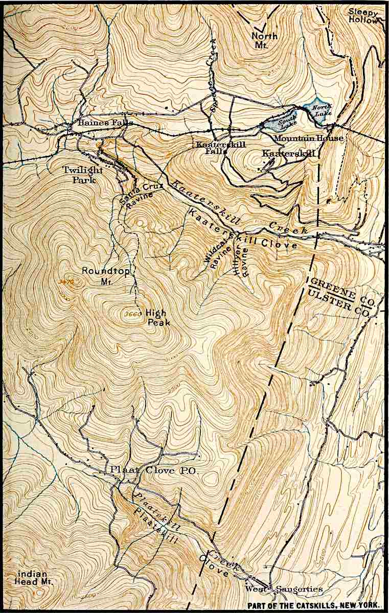
U. S. Geol. Surv.
Scale, 2+ mile per inch.
PART OF THE CATSKILLS, NEW YORK.
PLATE XII.
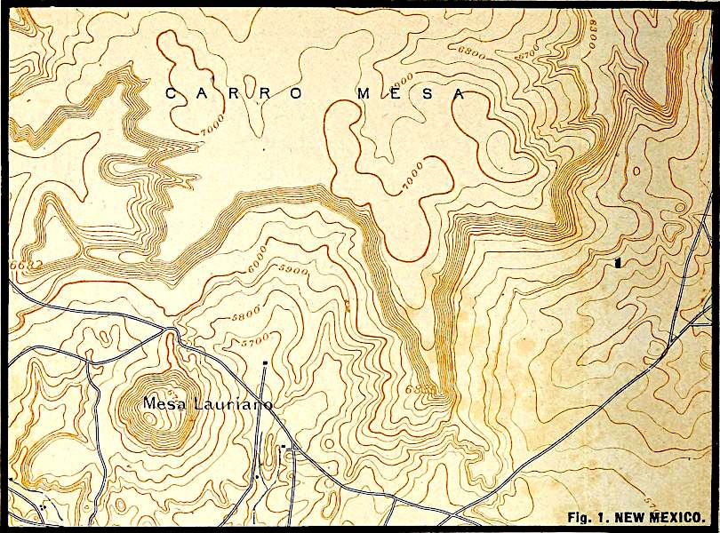
U. S. Geol. Surv.
Scale, 2+ mile per inch.
Fig.
1. NEW MEXICO.
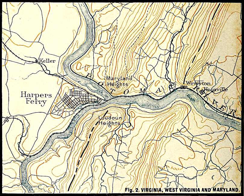
U. S. Geol. Surv.
Scale, 1+ mile per inch.
Fig.
2. VIRGINIA, WEST VIRGINIA AND MARYLAND.
ANALYSES OF AMERICAN RIVER-WATERS.
[Reduced to Parts per 1000 by Dr. H. J. Van Hoesen.]
Name of river Bear Croton Cumberland Delaware Hudson, N. Y. James
Collected at Evanston, Wy. Reservoir, New York City Reservoir at Nashville, Tenn. Reservoir at Trenton, N. J. ............ Richmond Water Works, Va.
Date Dec., 1873 1881 ............ ............ ............ Oct. 24. 1876, after light rain
Analyst F. W. Clarke E. Waller N. T. Lupton H. Wurtz C. F. Chandler W. H. Taylor
Reference Bulletin No. 9, U. S. Geol. Surv., p. 30 Water supply of New York City, 1881 Am. Chemist, July 16, 1876, p. 16 Geol. of N. J., 1868, p. 702 Public Health Papers, Vol. I, Am. Pub. Health Ass. Ann. Rept. Board of Health, Richmond, Va., 1876
Sodium, Na .0082 [34].00298 .01032 .00072 .00244 .00234
Potassium, K ...... .00154 .00050 .00178 .00058 .00251
Calcium, Ca .0432 .00905 .02987 .01104 .02220 .01284
Magnesium, Mg .0125 .00336 .00280 .00435 .00465 .00377
Chlorine, Cl .0049 .00213 .00299 .00121 .00581 .00105
Sulphuric acid, SO3 .0105 .00441 .00563 .00175 .01257 .00363
Phosphoric acid, H3PO ...... .00172 Trace
Nitric acid, HNO3 ...... ...... .00511 ...... ...... .00231
Silica, SiO2 .0070 .03360 Trace .00852 .00698 .01024
Alumina, Al2O3 .00047 .00041
Sesquioxide of iron, Fe2O3 ...... ...... ......
Sesquioxides of iron and alumina, Fe2O3 and Al2O3 ...... .00078 .00671 ...... .00120 ......
Sesquioxides of iron and manganese, Fe2O3 and Mn2O3 .00072
Carbonates of iron and manganese, FeCO3 and MnCO3
Oxide of iron, FeO ......
Oxide of manganese, MnO Trace ......
Hydrogen in bicarbonates, H .00121
Chloride and sulphate of sodium, NaCl, and Na2SO4 ......
Ammonia, NH4 ...... ...... .01087 ...... .00001
Organic matter .00400 .01666 .01197 .00299
Carbonates and sulphates of Na, K, and Mg ...... ...... ...... ...... ...... ......
.1845 .08433 .13786 .06795 .14238 .07246
ANALYSES OF AMERICAN RIVER-WATERS (continued).
[Reduced to Parts per 1000 by Dr. H. J. Van Hoesen.]
Name of river Los Angeles Maumee, O. Mississippi Ottawa Passaic Rio Grande del Norte Sacramento
Collected at Hydrant, City ater Works, New Orleans, La. St. Ann’s Lock, Montreal, Can. 4 miles above Newark, N. J. Fort Craig, New Mexico Hydrant, Sacramento, Cal. Hydrant at Los Angeles, Cal. ............
Date Sept. 8, 1878 ............ ............ Mar. 9, 1854 1851 1873 Sept., 1878
Analyst W. J. Jones C. F. Chandler W. J. Jones T. S. Hunt E. N. Horsford O. Loew W. J. Jones
Reference Rept. Cal. State Board of Health, 1878 Report of Toledo Water Works, 1881 Rept. La. State Board of Health, 1882, p. 370 Geol. of Canada, 1863, p. 567 Geol. of N. J., 1868, p. 708 U. S. Geog. Surv. west of 100th M., Vol. III. p. 576 Rept. Cal. State Board of Health, 1878
Sodium, Na .02968 .00162 .0310 .00239 .02357 .03220 .00200
Potassium, K ...... .00309 ...... .00139 .00163 .00063 ......
Calcium, Ca .01750 .02645 .0372 .00992 .01459 .01633 .01279
Magnesium, Mg .02097 .00443 ...... .00161 .00404 .00123 .00121
Chlorine, Cl .01044 .00250 .0480 .00076 .03192 .03604 ......
Carbonic acid, CO2 .05635 .04438 .0383 .02255 .02634 .01025 .00887
Sulphuric acid, SO3 .05724 .01401 .00194 .01716 .04700 .00397
Phosphoric acid, H3PO .02638 Trace Faint trace .0179
Nitric acid, HNO3 ...... ...... ...... Trace ......
Silica, SiO2 .02005 .00724 .02060 .01342 Trace .03167
Alumina, Al2O3 .00171 ...... Trace Trace .00120 Trace
Sesquioxide of iron, Fe2O3 .00100
Sesquioxides of iron and alumina, Fe2O3 and Al2O3 ...... ......
Sesquioxides of iron and manganese, Fe2O3 and Mn2O3 ...... ......
Carbonates of iron and manganese, FeCO3 and MnCO3 .00443 ...... ...... .01088
Oxide of iron, FeO Trace Trace
Oxide of manganese, MnO Trace
Hydrogen in bicarbonates, H ......
Chloride and sulphate of sodium, NaCl, and Na2SO4 ...... .02431
Ammonia, NH4 ...... Trace
Organic matter .00499 ...... .01392
Carbonates and sulphates of Na, K, and Mg ...... ...... .0154 ...... ...... ...... ......
.24475 .10971 .1699 .06116 .13287 .15760 .11484
ANALYSES OF AMERICAN RIVER-WATERS (continued).
[Reduced to Parts per 1000 by Dr. H. J. Van Hoesen.]
Name of river St. Lawrence Humboldt Truckee Walker Jordan Mohawk Genesee
South side Point des Cascades Collected at Battle Mt., Nev. Lake Tahoe, Nev. Mason Valley, Nev. Utah Lake Utica, N. Y. Rochester, N. Y.
Date Mar. 30, 1863 Dec., 1872 Oct., 1872 Oct., 1872 Nov., 1873
Analyst T. S. Hunt T. M. Chatard F. W. Clarke F. W. Clarke F. W. Clarke C. F. Chandler C. F. Chandler
Reference Geol. of Canada, 1863, p. 567 U. S. Geol. Surv., Monograph XI, p. 41 U. S. Geol. Surv., Monograph XI, p. 42 U. S. Geol. Surv., Monograph XI, p. 40 Bulletin No. 9, U. S. Geol. Surv., p. 29 Johnson’s Cyclopedia, Vol. IV Johnson’s Cyclopedia, Vol. IV
Sodium, Na .00513 .0467 .0073 .0318 .0178 .0036 .0044
Potassium, K .00115 .0100 .0033 Trace ...... .0009 .0023
Calcium, Ca .03233 .0489 .0093 .0228 .0558 .0318 .0417
Magnesium, Mg .00585 .0124 .0030 .0038 .0186 .0069 .00896
Chlorine, Cl .00242 .0075 .0023 .0131 .0124 .0023 .0024
Sulphuric acid, SO3 .00831 .0477 .0054 .0284 .1306 .0187 .0431
Phosphoric acid, H3PO Trace ......
Nitric acid, HNO3 ...... ...... ...... ...... ...... ......
Silica, SiO2 .03700 .0326 .0137 0.225 .0100 .0067 .0014
Alumina, Al2O3 .0013
Sesquioxide of iron, Fe2O3 ...... ......
Sesquioxides of iron and alumina, Fe2O3 and Al2O3 .0013 .0014
Sesquioxides of iron and manganese, Fe2O3 and Mn2O3
Carbonates of iron and manganese, FeCO3 and MnCO3 ......
Oxide of iron, FeO Trace ......
Oxide of manganese, MnO Trace ...... ......