Chapter III · (continued 2)
Reading edition
Hydrogen in bicarbonates, H ...... ...... ......
Chloride and sulphate of sodium, NaCl, and Na2SO4 ...... ...... ......
Ammonia, NH4 ...... ...... ......
Organic matter ...... ...... .0234 .0250
Carbonates and sulphates of Na, K, and Mg ...... ...... ...... ...... ...... ...... ......
.16055 .3615 .0730 .1800 .3060 .1525 019526
The following table[36] gives the percentage of material carried in suspension by various rivers:
River. Drainage Areas in Square Miles. Mean Annual Discharge (in Cubic Feet.) per Second. Total Tons Annually. Ratio of Sediment to Water by Weight. Height in Feet of Column of Sediment with a Base of One Square Mile. Thickness of Sediment in Inches if Spread over Drainage Area.
Potomac 11,043 20,160 5,557,250 1 : 3,575 4.0 .00433
Mississippi 1,244,000 610,000 406,250,000 1 : 1,500 241.4 .00223
Rio Grande 30,000 1,700 3,830,000 1 : 291 2.8 .00116
Uruguay 150,000 150,000 14,782,500 1 : 10,000 10.6 .00085
Rhone 34,800 65,850 36,000,000 1 : 1,775 31.1 .01075
Po 27,100 62,200 67,000,000 1 : 900 59.0 .01139
Danube 320,300 315,200 108,000,000 1 : 2,880 93.2 .00354
Nile 1,100,000 113,000 54,000,000 1 : 2,050 38.8 .00042
Irrawaddy 125,000 475,000 291,430,000 1 : 1,610 209.0 .02005
Mean 334,693 201,468 109,649,972 1 : 2,731 76.65 .00614
The composition of rain-water falling near London, as determined by analysis, was as follows:[37]
Organic carbon .99 part in 1,000,000 of water.
Organic nitrogen .22 “ “ “ “ “
Ammonia .50 “ “ “ “ “
Nitrogen as nitrates and nitrites .07 “ “ “ “ “
Chlorine 6.30 parts in“ “ “
Total solids 39.50 “ “ “ “ “
A comparison of the composition of rain-water with that of springs and rivers gives some idea of the solvent work of water. From a study of the water of nineteen of the principal rivers of the world Murray has compiled the following table[38] showing the amount of mineral matter in average river water:
MATERIAL IN SOLUTION IN ONE CUBIC MILE OF AVERAGE RIVER WATER.
Constituents. Tons in a Cubic Mile.
Calcium carbonate (CaCO3) 326,710
Magnesium carbonate (MgCO3) 112,870
Calcium phosphate (Ca3P2O8) 2,913
Calcium sulphate (CaSO4) 34,361
Sodium sulphate (Na2SO4) 31,805
Potassium sulphate (K2SO4) 20,358
Sodium nitrate (NaNO3) 26,800
Sodium chloride (NaCl) 16,657
Lithium chloride (LiCl) 2,462
Ammonium chloride (NH4Cl) 1,030
Silica (SiO2) 74,577
Ferric oxide (Fe2O3) 13,006
Alumina (Al2O3) 14,315
Manganese oxide (Mn2O3) 5,703
Organic matter 79,020
Total dissolved matter 762,587
Murray also estimates that the aggregate amount of water flowing into the sea annually is about 6528 cubic miles, which, on the above basis, would carry about 4,975,000,000 tons of mineral matter in solution.
A large number of analyses of waters of rivers from the United States and Canada give an average of about .15,044 part in a thousand of mineral matter in solution, more than one-third being CaCO3. The average amount of mineral matter in solution in 48 European streams cited by Bischoff[40] is .2127 part in a thousand, of which CaCO3 is rather more than half. The average mineral matter in solution in 36 rivers cited by Roth[41] (including some of those tabulated by Bischoff) is .2033 part in a thousand, of which CaCO3 is slightly less than one-half.
An average for American and European rivers, so far as determinable from data at hand, is about .1888 part in a thousand in solution, of which CaCO3 is slightly less than one-half. These last figures are probably not very far from an average for river water in general.
The following table shows the total amount of solids carried in solution by the rivers indicated:[42]
Rhine 5,816,805 tons per year.
Rhone 8,290,464 “ “ “
Danube 22,521,434 “ “ “
Thames 613,930 “ “ “
Nile 16,950,000 “ “ “
Croton 66,795 “ “ “
Hudson 438,000 “ “ “
Mississippi 112,832,171 “ “ “
ECONOMIC CONSIDERATIONS.
Certain considerations of human interest in connection with river erosion are worthy of note. When a drainage system has reached its mature stage its basin has the roughest topography which it will have at any time during that cycle of erosion. At that stage, therefore, road construction is relatively difficult. If the relief be great, roads must follow the valleys, or the crests of the ridges between them, if they would avoid heavy grades. In such regions roads are usually few and crooked.
The stage of development of valleys has an influence on the navigability of their streams. Streams well advanced in life are much more readily navigable than young ones, because their grades are lower and their volumes of water greater. Old streams, on the other hand, are sometimes depositing sand or silt along their lower courses to such an extent as to interfere with navigation.
At certain stages of their development the power of streams is more easily utilized than at others. Young streams, depending as they do for their supply on the rainfall of a limited area, are likely to be fitful in their flow, and therefore unreliable as a source of power. This is especially true where the precipitation is unequally distributed, and where the slopes are steep and free from forests. Because of their great volume, old and large streams, though sluggish, have great power, but it is less easily controlled. Where streams are large enough to be navigable industrial considerations often prevent the utilization of their power, the streams being more serviceable as highways than as sources of power. Other things being equal, it follows that streams are most available for water-power when they are large enough to have a moderately steady flow, and not so large as to be beyond ready control, or to be valuable for purposes of navigation.
Streams are subject to more disastrous floods in some stages of their development than in others. Floods resulting from heavy rains are likely to be greatest where the slopes above the drainage lines are on the whole greatest, for this is the condition under which the water is most quickly gathered into the drainage channels. The most disastrous floods, humanly speaking, are those which affect wide-bottomed valleys, where the flats are settled. In such cases a relatively slight rise may flood very extensive areas. In such valleys the most disastrous floods are generally in the spring, when the waters from the melting snows of the preceding winter are being discharged.[43] Many other considerations enter into the problem of floods. The presence of forests and other forms of vegetation on the slopes retards the flow of water into the valleys, and so tends to prevent floods, or at any rate to make them less severe. Porous soil and subsoil, or in their absence porous rock, absorb the rainfall, and prevent its prompt descent into the valleys and so tends to prevent or diminish floods.
The acreage of arable land within a given area stands in some relation to its drainage development. At an early stage in its erosion history, before an upland has been dissected by valleys, nearly all of it may be arable. Later, when drainage is at its maturity, and when hillsides and ridge slopes constitute a large part of the area, there is probably the least acreage of arable land. This is especially true if the slopes are so steep as to allow the soil to be readily washed away. At a still later stage, when the valley bottoms have become wide and the slopes of the ridges and hills so reduced as to be available, the area of cultivable land is again increased.
Marshes, ponds, and lakes have some bearing on the resources and industries of a region, and they stand in a more or less definite relation to the stage of erosion in which a region finds itself. In its youth ponds and lakes may occupy much of the surface; in its maturity they will have been largely drained.
These suggestions are sufficient to show that the topography of a region, even in so far as shaped by erosion, touches human interests at many points.
ANALYSIS OF EROSION.[44]
Erosion is the term applied to all the processes by which earthy matter or rock is loosened and removed from one place to another. It consists of three sub-processes, namely, weathering, transportation, and corrasion.
Weathering.
The term weathering is applied to nearly all those natural processes which tend to loosen or change the exposed surfaces of rock. The lettering of inscriptions on exposed marble becomes fainter and fainter as time goes by, and finally disappears, because the rock in which the letters were cut has weathered away. Some of it has crumbled off as the result of the expansion and contraction induced by changes of temperature, and some of it has been dissolved by the rain which has fallen upon it. In this case the weathering is effected partly by the atmosphere and partly by water. These are the chief, but not the only agents concerned in the general processes of weathering. Those phases of weathering which are the result of the activities of the atmosphere, whether physical or chemical, have been discussed in connection with the atmosphere (pp. 42 and 54).
The rain which falls upon the surface of exposed rock, and that which sinks through the soil to the solid rock below, dissolves, even if slowly, some of the rock constituents. Each constituent of a rock composed of several minerals may be looked upon as a binding material for the others. When one is dissolved the rock crumbles, much as mortar does when the lime which cements the sand is dissolved.
The solution of mineral matter by ground water, as well as the other chemical changes it effects, is greatly augmented by the impurities, especially carbonic and other organic gases, dissolved by the water from the atmosphere and the soil. The commonest chemical changes effected by the joint action of water and air, oxidation and carbonation, have been referred to in Chapter II. Hydration is more exclusively the work of water, and is one of the commonest processes of rock change, and often of rock disintegration. Numerous other less simple chemical changes resulting from the activities of ground water are constantly in progress, and in so far as they lead to the disintegration of rock are processes of weathering. Many chemical changes involve notable changes in volume of the mineral matter concerned. Merrill has calculated that in the conversion of the granitic rock of the vicinity of Washington, D. C., into soil, its volume has been increased 88 percent., largely as the result of hydration.[45] Even when the chemical changes do not themselves directly involve the disintegration of the rock, the accompanying increase of volume is sometimes sufficient to cause its physical disruption. This also may be regarded as a phase of weathering.
The weathering accomplished by water, or under its influence, proceeds at rates which vary with the composition of the rock, the amount and composition of the water, the temperature, and certain other factors less susceptible of brief statement. The weathering effected by ground water has a wider range both in area and depth than that due to changes of temperature, for while the latter is effective only where temperature changes are considerable, and where coherent material lies at the surface (p. 45), the former is operative to all depths to which water sinks.
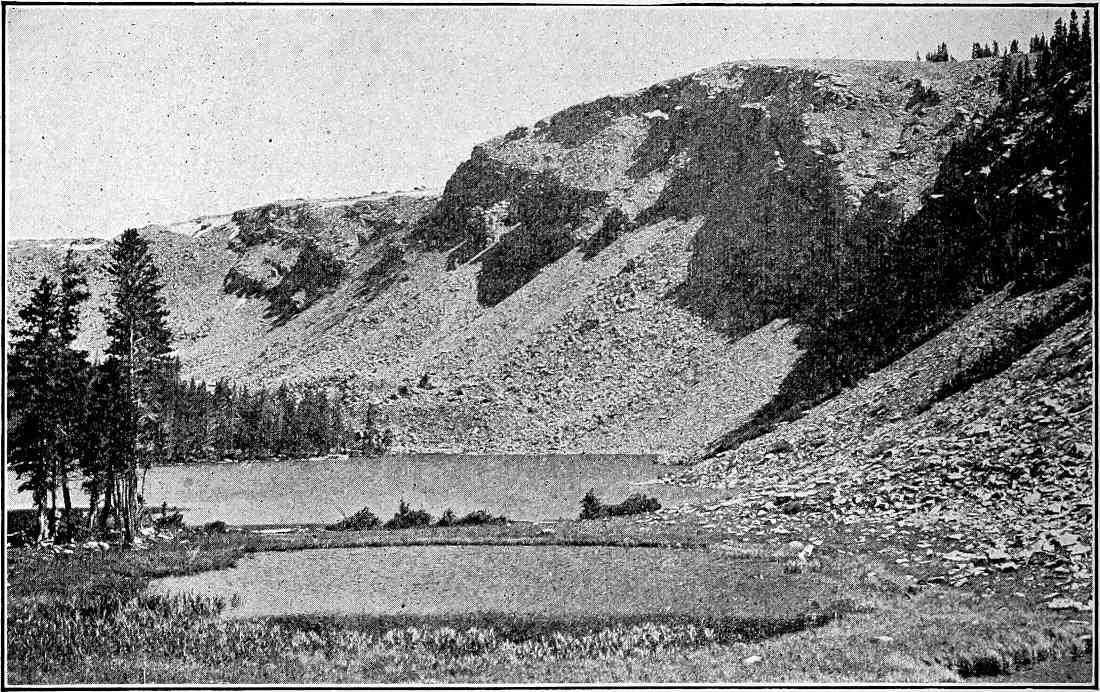
Fig.
94.—Talus accumulation at the base of a steep bluff. Weber Canyon, Uinta Mountains, Utah. The talus has accumulated since the last glaciation of the valley and is therefore of very recent origin. (Church.)
There are other processes of weathering not due directly either to the atmosphere or to water. The roots of trees and smaller plants frequently grow into cracks of rocks, and, increasing in size, act much like freezing water (p. 45) in similar situations. This wedge-work of roots is a phase of weathering.
From the faces of steep cliffs masses of rock frequently fall. However dislodged, their descent is effected by gravity. The quantities of débris at the bases of many cliffs, forming slopes of talus (Fig. 94), testify to the importance of the action of gravity in getting material from higher to lower levels. Another phase of gravity-work is shown in Fig. 95. Here, under the influence of gravity and expansion and contraction, due to freezing and thawing and wetting and drying, the surface material is creeping down slope. In the process the rock is being broken. The process illustrated by the figure involves weathering as well as other factors.
The foregoing are among the commoner processes of weathering, although they do not exhaust the list. The more active and tangible processes by which surface rocks are broken up, such as wave wear, river wear and glacier wear, are processes of corrasion. The mechanical wear effected by wind-driven sand might be considered either as corrasion or as weathering. It is more likely to be regarded as corrasion if the amount of wear is considerable enough to be obvious. Rock is sometimes decomposed by the chemical action of hot vapors, gases, and waters rising to the surface from considerable depths. This is often seen in volcanic regions. A conspicuous illustration is seen in the canyon of the Yellowstone in the National Park. Decay of this sort is perhaps not properly weathering, but is not always readily distinguished from it.
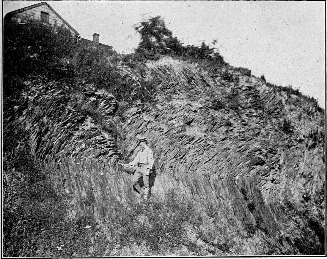
Fig.
95.—Shows the downward creep of soil and slaty rock under the influence of gravity.
The importance of weathering in the general processes of erosion is shown in many ways. In regions where the mantle rock is the product of the decay of the solid rock beneath, and such regions constitute a large portion of the earth’s surface, the soil and subsoil represent the excess of weathering over transportation. Since most of the earth’s surface is covered with soil to a greater or less depth, it is clear that, on the whole, weathering keeps ahead of transportation. Again, it is clear that the loosening of rock by weathering greatly increases the erosion which a given amount of moving water can accomplish. Not only this, but weathering plays a much more important rôle in the development of valleys than is commonly realized. This is best illustrated by the valleys of young swift streams. The valley which is not at its top ten times as wide as its stream is rare. The stream which has such a canyon has been cutting chiefly at its bottom. Ignoring its lateral corrasion, which is slight, the valley which it would cut would have a width equal to its own. This is illustrated by Fig. 96. Weathering in its broadest sense is largely responsible for the width of such a valley, in so far as it exceeds the width of the stream. The work of weathering, slope wash, etc., has been to get the material which originally lay between a, b, and c down to the stream. The stream has then carried it away. The above illustration would not apply to old and sluggish streams, for they, by their meandering, widen their valleys independently of weathering.
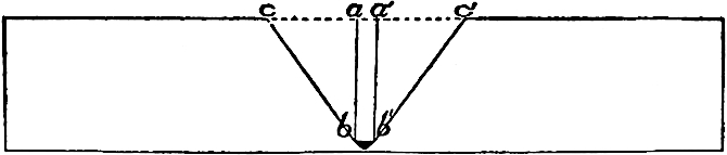
Fig.
96.—Diagram of a valley the top of which is ten times the width of the stream.
Weathering is a part of erosion, but only a part. In so far as it is effected by solution the process involves the transportation of that which is dissolved to some other point. Transportation is also involved to some extent in the other processes of weathering, but the central idea of the processes embraced under this term is the loosening and disrupting of rock by which it is prepared for transportation.
Transportation.
The second element of erosion is transportation. The transportation of mechanical sediment is to be distinguished from the transportation of materials in solution. In so far as mineral matter is dissolved it becomes, so far as flowage is concerned, a part of the stream. If the quantity dissolved were large it might influence the mobility of the water, but the amount is usually too slight to influence the flow sensibly.
The sediment transported by a stream is either rolled along its bottom or carried in suspension at some higher level. The coarser materials (gravel and sand) are carried chiefly in the former position, and the finer (silt and mud) largely in the latter.
Transporting power and velocity.—The transporting power of running water depends on its velocity. The formula expressing the relations between them is as follows: Transporting power, t, varies as the sixth power of velocity, v, (tαv6); that is, doubling the velocity of the stream increases its transporting power 64-fold. Strictly speaking, this means that if a stream of given velocity is just able to move a stone of a given size, a stream with double that velocity will be just able to move a stone of the same shape 64 times as large as the first. This may be graphically illustrated as follows: Let a current be supposed just able to move the cube a (Fig. 97). If the current be doubled, twice as much water will strike the same surface with twice the force in the same time; that is, the force exerted on the cube a will be quadrupled. It will, therefore, be able not only to move the one cube, but it will be able to move three other cubes (b, c, and d) besides (Fig. 98). The same current against any other equal surface would also be able to move four small cubes, and there are sixteen such surfaces on the face of the large cube (Fig. 99). It follows that the dimension of the cube which the stream with the doubled velocity can move is four times as great as that of the cube which the original current could move, and the cubical contents of such a cube is 64 times as great as that of the first (64 = 26) (Fig. 99). Swift streams, therefore, have enormously greater power of transportation than sluggish ones. It does not necessarily follow that transportation keeps pace with transporting power; that depends on the accessibility of materials suitable for transportation. A stream of great transporting power, like the Niagara at its rapids, may carry little sediment, because there is little to be had.
The velocity of a stream depends chiefly on three elements—its gradient, its volume, and its load, (i.e., the sediment it is moving). The higher the gradient the greater the volume, and the less the load the greater the velocity. The relation between gradient and velocity is evident; that between volume and velocity is illustrated by every stream in time of flood, when its rate of flow is greatly increased. The relation between velocity and load is less obvious, but none the less definite. Every particle of sediment carried by a stream makes a draught on its energy, and energy expended in this way reduces the velocity. The draught on a stream’s energy of a particle carried in suspension is measured by its mass into the distance it would fall in a unit of time in still water. It follows that a large particle makes a stronger draught on a stream’s energy than the same amount of material in smaller pieces. It follows also that the comminution of sediment facilitates transportation in much more than a simple ratio, for not only can a given amount of energy carry more fine material than coarse, but a larger proportion of a stream’s energy can be utilized in the transportation of the fine.
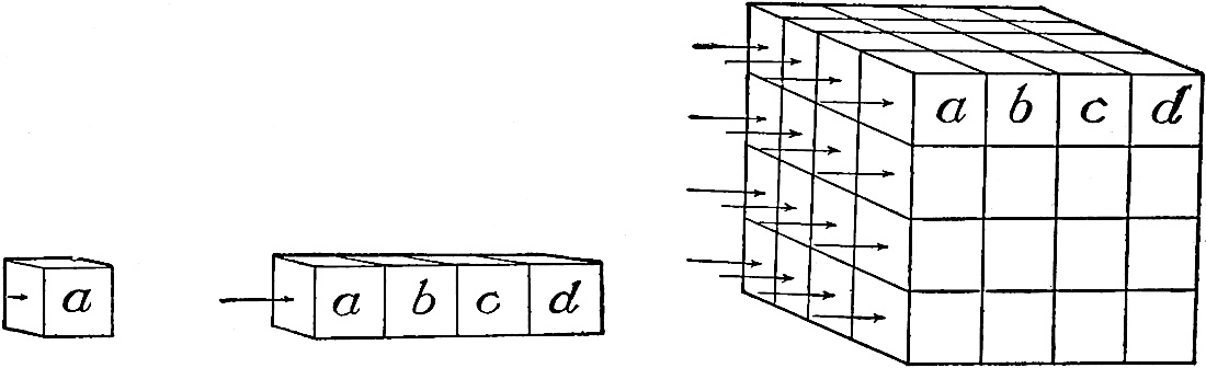
Fig.
97–99.—Diagrammatic representation of the effect of increased velocity on transporting power.
How sediment is carried.—Coarse materials, such as gravel stones, are rolled along the bottoms of the swift streams which carry them. Their movement is effected by the impact of water. The same is true to a large extent of sand grains, especially if they be coarse. So far as concerns the material rolled along the bottom it is to be noted that a stream’s transporting power is dependent on the velocity of the water at its bottom. This is much less than the surface, or even the average velocity. The particles of fine sediments, such as silt and mud, are frequently carried by streams quite above their bottoms, as shown by the roiliness of many streams. A particle of mud is usually a small bit of mineral matter, the specific gravity of which is two or three times that of water. Why does it not sink through the water and come to rest at the bottom of the stream, or suffer transportation as the gravel does?
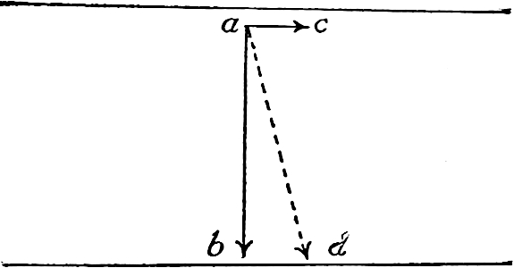
Fig.
100.—Diagram to illustrate the relative strength of the two forces acting on a particle in suspension. The arrows represent the relative strength of the two forces when the stream’s velocity is 5 miles per hour. No account is taken in the diagram of the viscosity of the water, or of the acceleration of velocity of fall.
A particle of sediment in running water is obviously subject to two forces, that of the current which tends to move it nearly horizontally down-stream, and that of gravity which tends to carry it to the bed of the stream. In Fig. 100, the arrows ab and ac represent respectively the relative force of gravity and a current of 5 miles per hour. As a result of these two forces the particle would tend to descend in the general direction of ad, a line which represents the resultant of these forces, though not the exact path which a particle acted on by them would take in water. If a river were the simple straightforward current which it is popularly thought to be, a particle in suspension would reach its bottom in the time it would take to sink through an equal depth of still water, for the descent would be none the less certain and none the less prompt because of the forward movement of the water. The current would simply be a factor in determining the position of the particle when it reached the bottom, not the time of reaching it. Very fine particles, like those of clay, though having the same specific gravity as grains of sand, would sink less readily than coarser ones, because they expose larger surfaces, relative to their mass, to the water through which they sink. But even such particles, unless of extraordinary fineness, would presently reach the bottom if acted on only by a horizontal current and gravity. Since even sediment which is not of exceeding fineness is kept in suspension it is clear that some other factor is involved. This is found, in part at least, in the subordinate upward currents in a stream.
Where a bowlder occurs in the bed of a stream (Fig. 101) the water which strikes it is in part forced up over it. If there be many bowlders the process is frequently repeated, and the number of upward currents is great. Any roughness will serve the same purpose, and every stream’s bed is rough to a greater or less extent. Where there are roughnesses at the sides of a channel, currents are started which flow from them toward the center. The varying velocities of the different parts of a stream serve a similar purpose. The curves in a river tend to give the water a rotatory movement. A river is therefore to be looked upon not as a single straightforward current, but as a multitude of currents, some rising from the bottom toward the top, some descending from top to bottom, some diverging from the center toward the sides, and some converging from the sides toward the center. The existence of these subordinate currents is often evident from the boiling and eddying readily seen in many streams. It is, of course, true that the sum of the upward currents is always less than the sum of the downward, so that the aggregate motion of the water is down slope; but it is also true that minor upward currents are common. Sediment in suspension is held up chiefly by such currents, which, locally and temporarily, overcome the effect of gravity. The particles in suspension are constantly tending to fall, and frequently falling; but before they reach the bottom many of them are seized and carried upward by the subordinate currents, only to sink and be carried up again. Even if they reach the bottom, as they frequently do, they may be picked up again. It is probable that every particle of sediment of such size that it would sink readily in still water is dropped and picked up many times in the course of any long river journey, and its periods of rest often exceed its periods of movement.

Fig.
101.—Diagram to illustrate the effect of bowlders,
a
and
b
, in a stream’s bed on the currents of water impinging against them.
Independently of the subordinate currents, the different velocities of the different parts of a stream tend to keep materials in suspension by exerting different pressures on the different sides of suspended particles.[46]
River ice sometimes facilitates the transportation of débris which the water alone could not carry. The ice freezes to bowlders in the banks of the streams, to those which are partially submerged, and sometimes to those altogether submerged beneath slight depths of water. When the ice breaks up in the spring such bowlders, buoyed up by the ice, may be floated far down the stream. The influence of ice in this connection is most considerable in high latitudes, but it is of consequence as far south as Virginia, where the river deposits sometimes contain bowlders which the unaided streams could not have carried. Ground ice sometimes forms about bowlders in the bottoms of streams, especially in the quiet pools of turbulent rivers, and floats them to the surface before the surface itself is frozen.[47] In the floods of spring rivers often spread their ice widely over their flood-plains. It is sometimes massed in constricted portions of valleys so as to form great dams, the breaking of which is attended with great destruction.
Corrasion.
Abrasion.—The wear effected by running water is corrasion. So long as the materials to be carried away are incoherent it is easy to see how running water picks them up and carries them forward. The water which gathers in the depressions on the slope of a cultivated field gathers earthy matter from the surface over which it passes, even before it is concentrated into rills, and the rills continue the process. Thus the loose materials of the surface are gathered at the very sources of the streams, and the amount of sediment in the water after a heavy shower, even at the head of the stream, may be great. The run-off from the slopes of any valley in any part of its course likewise brings sediment to the stream, which gathers more from its bed whereever it flows with sufficient velocity over incoherent material. Streams also undercut their banks, and receive new load from the fall of the overhanging material.
By far the larger part of the sediment acquired by a normal stream is made up of material loosened in advance by the processes of weathering. The stream, or the waters which get together to make the stream, find them ready-made; but rivers frequently wear rock which is not weathered, for the principal valleys of the earth’s surface are cut in solid rock, and many of them in rock of exceeding hardness. How does the stream wear the solid rock?
When a stream flows over a rock bed, the wear which it accomplishes depends chiefly on the character of the rock, the velocity of the stream, and the load it carries. If the rock be stratified and in thin layers, and if these thin layers be broken by numerous joints at high angles to the stratification planes, the impact of the water of a clear stream of even moderate strength may be effective in dislodging bits of the rock. This condition of things is often seen where streams run on beds of shale or slate. If the rock be hard and without bedding-planes and joints, or if its layers be thick and its joints few, clear water will be much less effective. If the surface of the rock be rough, the mechanical action of a swift stream of clear water might still produce some effect on it; but if massive hard rock presents a smooth surface to a clear stream, the mechanical effect of even a swift current is slight.
This general principle is illustrated by the Niagara River. Just above the falls the current is swift. When the river is essentially free from sediment, the surface of the limestone near the bank beneath it is sometimes distinctly green from the presence of the one-celled plants (fresh-water algæ) which grow upon it. The whole force of the mighty torrent is not able to sweep them from their moorings. Were the stream supplied with a tithe of the sand which it is capable of carrying, it would not take many hours, and perhaps not many minutes, to remove the last trace of vegetation. This illustration furnishes a clue to the method by which the erosion of solid rock in a stream’s bed is effected.
It has been seen that the ingathering waters which make a stream often have abundant sediment before they reach well-defined stream channels, and that the streams continue to gather sediment whereever their beds are composed of material which is readily detached. The sediments which the stream carries are the tools with which it works. Without them it is relatively impotent, so far as the abrasion of solid rock is concerned; with them, it may wear any rock over which it passes (Fig. 102).
We have next to inquire the methods by which running water uses its tools in the excavation of valleys. When gravel is rolled along in the channel of a stream there is friction between it and the bed over which it moves. If the pebbles be as hard as the bed over which they are rolled their movement must result in its wear, and even if they be softer more or less wear takes place. As the moving stones wear the rock of the stream’s bed they are themselves worn by impact with it and with one another. In all cases the softer material suffers the more rapid wear. The first effect of wear on materials in transportation is the reduction of their rugosities of surface. The projecting points and sharp angles are worn off, and the stones are reduced to rounded water-worn forms. The particles broken off make grains of sand, or, if very fine, particles of silt or mud. Even after a stone has been rounded it is subject to further wear and reduction, and in the course of time may be literally worn out.
The sediment carried in suspension, as well as that rolled along the bottom, may wear the rock bed of a stream. When a grain of sand in suspension escapes from an upward moving current it may not sink quietly. If it be caught by a downward current it may be made to strike a blow on the bed of the stream, and the effect of the blow is to wear the surface which receives it. The larger the grain and the stronger the current the greater the wear.
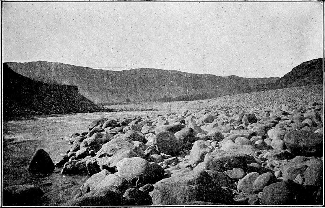
Fig.
102.—Some of the tools with which a stream works. The cobbles and bowlders have been shifted by the stream in its flow. Other stones and bowlders now in transit cause the ripples in the stream. The Chelan River, Wash., just above its junction with the Columbia. (Willis,
U. S. Geol. Surv.
)
The ceaseless repetition of the blows struck by the material in suspension, or rolled on its bottom, hour after hour, day after day, and year after year, will accomplish sensible results. In the long course of the ages this process has excavated deep valleys. Concomitant processes are largely concerned in making valleys wide, but the depth of valleys cut in solid rock is chiefly the result of the impact and friction of the sediment in transportation.
The wear effected in this way is not proportional to the number of blows struck. Since every pebble and every grain of sand carried diminishes the velocity of a stream, and since with diminished velocity the force of the blows struck is diminished, it follows that the blows may become so weak, as the result of their multiplication, as to be ineffective. The larger the load, therefore, which the stream carries, the more the tools with which it has to work, but the less effectively can it use them; and the load may be so far increased as to destroy its corrasive power altogether. On the other hand, the smaller the load of the stream the greater its velocity and the more effectively will its tools be used; but their number may be so far reduced that their aggregate effect is slight. To accomplish the greatest results on a bed of solid rock a stream must have tools to work with, but must not be so heavily burdened as to interfere with its effective use of them.
Whatever the cause of their unequal velocities swift and slow streams corrade their valleys differently. The erosion of a swift stream is chiefly at the bottom of its channel. The sluggish stream lowers its channel less rapidly, while lateral erosion is relatively more important. The result is that slow streams increase the width of their valleys more than the depth, while swift streams increase the depth more than the width. It follows that slow streams develop flats, while swift ones do not. Not only is a slow stream more likely to have a flat, and therefore a better chance to meander, but it is more likely to take advantage of opportunities in this line, for a slow stream gets out of the way for such obstacles as it may encounter, while a swift stream is much more likely to get obstacles out of its way.
Special phases of corrasion are introduced where waterfalls and other peculiarities dependent on inequalities of rock resistance occur.
Solution.—In most cases the solution effected by a stream is much less important than its mechanical work. Only when conditions are unfavorable to the latter, is solution the chief factor in the excavation of a valley. This may be the case where a stream’s bed is over soluble rock, such as limestone, and where the stream is clear, or its gradient so low that its current is sluggish. The solvent power of water is not influenced by the presence of sediment, though the presence of sediment offers the water a greater surface on which to work.
CONDITIONS AFFECTING THE RATE OF EROSION.
In considering the rate of erosion, both the work of the stream in its valley and that of the general run-off are to be considered. The conditions which favor the most rapid erosion in a stream’s channel are not necessarily those which determine most rapid degradation in the basin outside of the valley.
The Influence of Declivity.
In general the greater the declivity the more rapid the rate of erosion, whether in the stream’s channel or on the slopes above it. The truth of this conclusion is illustrated by the great erosive power of swift streams as compared with slow ones.
It does not follow, however, that high declivity favors each element of erosion. The effect of declivity on weathering is far from simple. For example, great declivity, by allowing more of the rainfall to flow off over the surface, and by causing it to flow off more promptly, restricts the work of solution, and therefore of decomposition, both at the surface and beneath it. High declivity is also unfavorable to the growth of vegetation, and so to the wedge-work of roots. On the other hand, a given amount of wedge-work of roots and ice is more effective where the slope is steep than where it is gentle, for such materials as are loosened descend the slopes more readily. The prompt removal of weathered materials, by exposing fresh surfaces of rock, accelerates weathering. The total amount of weathering may therefore not be diminished by the increase of slope, even though certain of its processes are hindered.
The effect of high declivity on transportation, the second element of erosion, is too patent to need explanation.
Corrasion likewise is favored by high declivity, for the abrasive power of a stream increases as the square of its velocity. With corrasive power increased, corrasion will also be increased if the water has tools to work with. Since high declivity greatly increases both the transporting and the corrasive power of running water, and favors certain elements of weathering, it is clear that the aggregate effect of high declivity is to favor erosion, whether in the channel of the stream or on the general surface of its drainage basin.
The Influence of Rock.
The physical constitution, the chemical composition, and the stratigraphy of a rock formation, influence the rate at which it may be broken up and carried away. Clastic or fragmental rocks are usually stratified and made up of cemented pebbles (conglomerate), sand grains (sandstone), or particles of mud (shale). Igneous rocks, such as granite, are massive instead of stratified, and are usually made up of great numbers of interlocking crystals which bind one another together. Some crystalline rocks, such as schists, though not stratified, possess cleavage, which has much the effect of stratification, so far as erosion is concerned. All rocks are affected by systems of more or less nearly vertical cracks called joints. All these structures have their influence upon the rate of degradation.
Physical constitution.—Clastic rocks may be firmly cemented, or their constituents may be loosely bound together. The less the coherence the more ready the disintegration, and the finer the particles the more easily are they carried away. When the particles in transportation are angular they effect more wear on the bed over which they move, and on one another, than when they are round. The difference is great where the particles are large, and little where they are very small. If the materials carried be harder than the bed over which they pass, corrasion of the latter is favored.
Chemical composition.—Something also depends on the chemical composition of the rock, since this affects its solubility, and therefore its rate of decomposition. The more soluble the rock the larger the proportion of it which will be taken away in solution; but it does not follow that the most soluble rock will be most rapidly eroded, since the rate of erosion depends on abrasion as well as solution, and a rock which is readily soluble, as rocks go, may be less easily abraded than a rock which is made of discrete and insoluble particles bound together by a soluble cement. In such rocks, for example a sandstone in which the grains are cemented together by lime carbonate, the solution of the cement sets free a considerable quantity of sand, so that a small amount of solution prepares a large amount of sediment for removal. A stream might cut its valley much more rapidly in such a sandstone than in a compact limestone, though the latter is, as a whole, the more soluble. The constituent minerals of crystalline rocks resist solution and decay unequally, and when any one is dissolved or decomposed the rock crumbles and the less soluble constituents are ready for removal by mechanical means. So long as the material loosened by disintegration is removed, chemical heterogeneity favors erosion; but if the loosened débris is not removed erosion is not favored by chemical heterogeneity. In such a case erosion would be most rapid where the rock was most soluble.
Structure.—The structure of the rock has much to do with the rate of its erosion. Other things being equal, stratified rock is more readily eroded than massive rock, since stratification-planes are planes of cleavage, and therefore of weakness. Taking advantage of these planes the water has less breaking to perform to reduce the material to a transportable condition. For the same reason a thin-bedded formation is more easily eroded than a thick-bedded one.
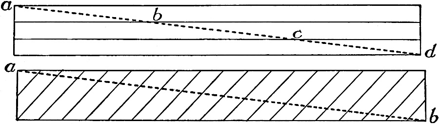
Fig.
103 and 104.—Diagrams to illustrate the fact that a stream crosses many more cleavage-planes when the beds of rock are inclined than when they are horizontal.
The beds of stratified rock may be horizontal, vertical, or inclined, and inclined strata may stand at any angle between horizontality and verticality. In indurated formations the rate of erosion is influenced both by the position of the strata and by the relation of the direction of the flowing water to their dip and strike. On the whole the strata which are horizontal, or but slightly inclined, are probably less favorable for rapid erosion than those which are vertical or inclined at considerable angles. This is at least true where the layers are of uniform hardness and the joints infrequent.
Horizontal strata expose fewer cleavage planes to the water flowing over them than strata in any other position. In Fig. 103 the stream which has the profile ad crosses bedding-planes at b and c. In Fig. 104, where the beds dip up-stream, many more division-planes are crossed in the same distance. Since bedding-planes are planes of weakness, it follows that horizontal and nearly horizontal strata are not, under ordinary conditions of erosion, in a position favorable for most rapid wear. When strata are horizontal, it makes no difference which way the stream runs, for the current sustains the same relation to the cleavage-planes whatever its course.
In the case of incoherent material the position of the beds, or even their existence, has little influence on the rate of erosion. Such formations are weak in all directions, not simply along bedding-planes.
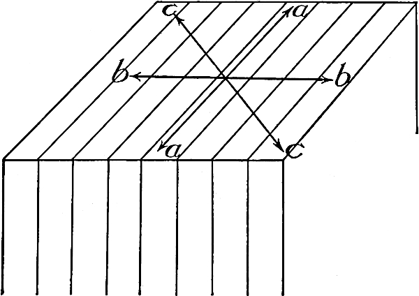
Fig.
105.—Diagram to illustrate the various relations a stream may sustain to the outcrop of vertical layers of rock.
When the strata are vertical, three distinct cases may arise (Fig. 105). The stream may flow (1) with the strike (aa); (2) at right angles to the strike (bb); or (3) oblique to it (cc) at any angle whatsoever. It is perhaps not possible to say which of these positions is most favorable for erosion, for the character of the rock, the thickness of its layers, its ability to stand with steep slopes, and the strength of the currents concerned, would influence the result. A stream which flows at right angles to the strike (bb, Fig. 105) would cross more cleavage-planes in a given distance than a stream flowing in any other direction, and would strike the outcropping edges of layers at the angle of greatest advantage. A stream flowing along the strike (aa), on the other hand, has better opportunity to sink its channel on cleavage-planes, and the current oblique to the strike (cc), has some of the advantages of each of the others.
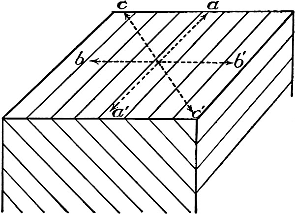
Fig.
106.—Diagram to illustrate the various relations a stream may sustain to the outcrops of inclined layers of rock.
When the strata are inclined five cases may arise. (1) The stream may be parallel to the strike (aa, Fig. 106), when it makes no difference which way the current flows; it may be at right angles to the strike (bb′), and (2) flowing with the dip (toward b′), or (3) against it (toward b); it may be oblique to the strike, and flowing (4) in the general direction of dip (toward c′); or (5) in the opposite direction (toward c). As before, the stream flowing at right angles to the strike would cross the largest number of layers in a given distance, and so have an opportunity to take advantage of more cleavage-planes than a stream in any other position. But in the case of inclined strata a new element enters into the problem. When the stream flows parallel to the strike, the valley which is in process of deepening is not sunk vertically, but is shifted more or less in the direction of the dip (Fig. 107). This is called monoclinal shifting. The result is that there is a constant tendency to undermine (sap) the valley bluff on the down-dip side, and this process of sapping will, according to its rate, accelerate the growth of the valley, especially in width. Monoclinal shifting is favored by the presence of a hard layer (H), as shown in Fig. 107, if this stratum is the bed of the stream.
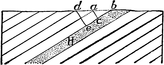
Fig.
107.—Diagram to illustrate monoclinal shifting. The valley
abc
, as seen in cross-section, becomes
deb
, as the stream lowers its channel.
In the second and third cases mentioned above, the only difference is in the angle at which the current strikes the outcropping edges of layers and laminæ. The mechanical advantage is with the stream which flows with the dip. In the fourth and fifth cases something will depend on the angle which the stream’s course makes with the strike. In all these cases, as in those where the strata are vertical, much will depend on the thickness and resistance of the layers and on the strength of the currents concerned.
The Influence of Climate.
Climate has both a direct and an indirect effect on erosion. Its direct influence is through precipitation, evaporation, changes of temperature, and wind; its indirect, through vegetation. Like declivity and rock structure, climate does not affect all elements of erosion equally.
The chief elements of climate are temperature, moisture, and atmospheric movements; the principal factors which influence it are latitude, altitude, distance from the sea, direction of prevailing winds, and topographic relations.
The effects of variations in temperature on rock weathering have already been discussed (p. 43). They are chiefly mechanical, and are seen at their best where the daily range is great.
High temperature favors chemical action, and the weathering of rock by decomposition is at its best in the presence of abundant moisture in regions where the temperature is uniformly high. Furthermore, a warm moist climate favors the growth of vegetation, the decay of which supplies the water with organic acids which greatly increase its solvent power. The climatic conditions favoring mechanical weathering are therefore different from those favoring chemical weathering. High temperature and abundant moisture and vegetation are found in many tropical regions, and here the rock is often decomposed to greater depths, on the whole, than in high latitudes. How far this is the result of rapid weathering, and how far of slow removal, due in part to the protective influence of the plants, cannot be affirmed. If the weathered material is not removed, it will presently become a mantle thick enough to retard the processes which brought it into existence.
So long as the water of the surface and that in the soil remains unfrozen, temperature affects neither corrasion nor transportation. But in middle and high latitudes the surface is frozen for some part of each year. During this time corrasion is at a minimum, for although the streams continue to flow there is relatively little water running over the surface outside the drainage channels, and that little is relatively ineffective. Under some conditions, therefore, temperature affects both corrasion and transportation.
The humidity of the atmosphere has an influence even more important than that of temperature on the rate of erosion, and its influence is exerted on each of the elements of that complex process. A moist atmosphere favors oxidation, carbonation, hydration, and the growth of vegetation, all of which promote certain phases of rock weathering. On the other hand, humidity tends to prevent sudden and considerable variations in temperature, thus checking the weathering effected by this means. Precipitation, the most important single factor in determining the rate of erosion, is dependent on atmospheric humidity. Its amount, its kind (rain or snow), and its distribution in time, are the elements which determine its effectiveness in any given place.
Other things being equal the greater the amount of precipitation the more rapid the corrasion and transportation. Much, however, depends on its distribution in time. A given amount of rainfall may be distributed equally through the year, or it may fall during a wet season only. The maximum inequality of distribution would occur if all the rainfall of a given period were concentrated in a single shower. With such concentration the volume of water flowing off over the surface immediately after the down-pour would be greater than under any other conditions of precipitation, and since velocity is increased with volume, and erosive power with velocity, it follows that the erosive power of a given amount of water would be greater under these circumstances than under any other. Furthermore, a larger proportion of the precipitation would run off over the surface under these circumstances than under any other, for less of it would sink beneath the surface and less would be evaporated. If erosive power and rate of erosion were equal terms, this would therefore be the condition for greatest erosion; but erosive power and rate of erosion do not always correspond. If the water falling in this way could get hold of all the material it could carry, extreme concentration of precipitation would be the condition favorable for most rapid erosion. But if the amount of available material for transportation is slight, a large part of the force of the water could not be utilized in erosion. It follows that if there were a large amount of disintegrated material on the surface, erosion would be greater the greater the concentration of precipitation. If, on the other hand, there were but little disintegrated material on the surface, frequent showers, with intervening periods when conditions were favorable for weathering, that is, for preparing material for transportation, might be more favorable for rapid erosion. While the total energy of running water available for erosion under these conditions would be less than before, there might in the long run be more material for transport; for weathering in the presence of moisture, and all that goes with it, might be more effective in preparing material for transportation, than weathering during the long periods of drought which would occur if the precipitation were concentrated to its maximum. Temperature favoring, the uniform distribution of moisture through the year would allow the growth of vegetation, which, although favoring some processes of weathering, retards erosion in general. While therefore it is not possible to say what distribution of rainfall favors most rapid erosion without knowing the nature of the surface on which it is to fall, enough has been said to show that the problem is by no means a simple one. Some of the most striking phases of topography developed by erosion, such as those of the Bad Lands (Figs. 75 to 78, and 108), are developed where the rainfall is unequally distributed in time, and too slight or too infrequent to support abundant vegetation.
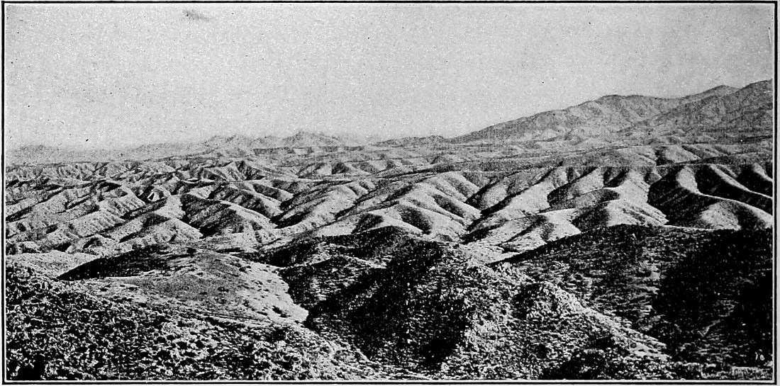
Fig.
108.—Bad-land topography developed under conditions of aridity and unequal distribution of rainfall. Slope of Pinal Mountains, Ariz. (Ransome,
U. S. Geol. Surv.
)
During its fall, and immediately after, rain is more effective than an equal amount of snow; but the snow may be accumulated through a considerable period of the year, and then melted rapidly, when it has an effect comparable to that which would be produced by the concentration of the rainfall into a limited period of the year. If the ground beneath be frozen when the snow melts (and this is often the case) the erosion accomplished by the resulting water will be diminished.
Except in dry regions, where wind-work sometimes exceeds water-work, the movements of the atmosphere are of less importance directly than precipitation in determining the rate of erosion. But even in regions which are not arid the winds have much to do with the rate of evaporation and the distribution of rainfall, so that their indirect effect is great. Even their direct effects in moist climates are not to be lost sight of, for even here the surface is sometimes dry enough to yield dust and sand, and the uprooting of trees so disturbs the surface as to make earthy débris more accessible to wind and water. Where trees gain precarious footholds on steep slopes, as they often do, they are likely to be overturned as soon as they are large enough to offer considerable resistance to the wind, and in the overturning, large quantities of rock are sometimes loosened and carried down the slope by gravity. This phase of destructive work is seen at its best on the walls of gorges, where trees often flourish until their tops project above the rim of the valley.
Through vegetation, climate influences erosion in ways which are easily defined qualitatively, but not quantitatively. Both by its growth (wedge-work of roots) and by its decay (supplying CO2, etc., to descending waters) it favors certain phases of weathering; but, on the other hand, it retards corrasion and transportation both by wind and water. This is well shown along the banks of streams and on the faces of cliffs, in clay, sand, etc. Its aggregate effect is probably unfavorable to erosion by mechanical means, and favorable to that by chemical processes.
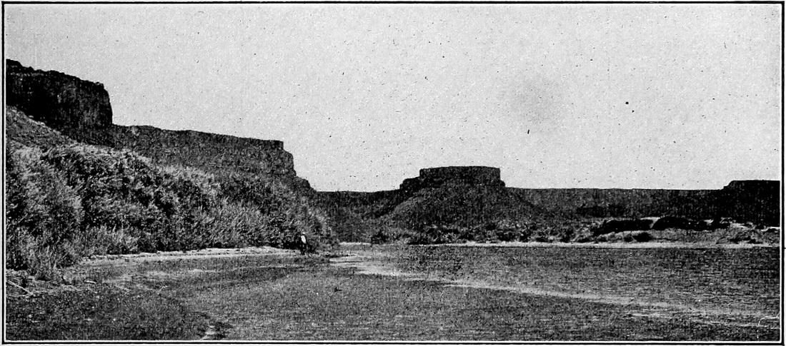
Fig.
109.—Characteristic cliffs of high arid regions. Right wall of Snake River canyon, nearly opposite the mouth of Salmon River, Id. Two spring-formed coves, with “Castle Rock” between. (Russell,
U. S. Geol. Surv.
)
Erosion in high arid regions differs from that in regions of abundant rainfall in several ways. It is obvious that the valleys will develop more slowly in the former, that they will remain young longer, that the period necessary for the dissection of the surface is greater, that the watercourses will be less numerous, and that fewer of them will have permanent streams. There are certain other differences which are less obvious. If the arid region be high and composed of heterogeneous strata, the topography which erosion develops is more angular (Fig. 83) than that of the humid region. This is because there is less rock decay, and less vegetation to hold the products of decay. The more resistant beds of rock therefore come into greater prominence, especially on slopes, where they develop cliffs (Figs. 109 and 110). These general principles find abundant illustration in the plateaus of the western part of the United States,[48] where the cliffs are by no means confined to the immediate valleys of the streams (Fig. 1, Pl. XII).
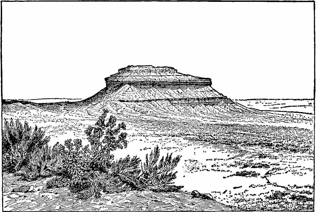
Fig.
110.—A Butte. A characteristic feature of the arid plateau region of the West. (Dutton, Mono. II,
U. S. Geol. Surv.
)
EFFECTS OF UNEQUAL HARDNESS.
In the preceding pages incidental reference has been made to the results of inequalities of rock resistance. This topic will now be considered more fully.
Rapids and falls.—Returning for a moment to the hypothetical island with which our study of erosion began, let a horizontal layer of hard rock be assumed to run through it (H, Fig. 111). As the rain falls on the land and runs off over it, wear will be less rapid where the hard layer comes to the surface than at the higher or lower levels. As a result, the slope will become steeper at and below the outcrop of the hard layer, and less steep immediately above it, as shown by ab in Fig. 111. Under these conditions the water passing over the hard ledge constitutes rapids. The increased erosion which accompanies the increased velocity makes the rapids more rapid. The process may continue until the water falls, rather than flows over the hard layer (cd, Fig. 111). With continued rainfall the edges of the hard layer, together with the slopes above and below, would continue to recede toward the center of the island. Under conditions of absolute homogeneity of material, save for the hard layer specified, no valley would be developed, and therefore no stream.
If the surface was so changed as to allow of the development of a valley (p. 63) the same principles would be applicable. As an active stream passes from a hard layer to one less resistant, the greater wear on the latter gives origin to rapids. At first the rapids would be slight (a, Fig. 112), but would become more considerable (b) as time and erosion go on. When the bed of the rapids becomes sufficiently steep, the rapids become falls[49] (cd). When the water falls rather than flows over the rock surface below the hard layer, erosion assumes a new phase. The hard layer is then undermined, and the undermining causes the falls to recede. This phase of erosion is sometimes called sapping.

Fig.
111.—Diagram representing a horizontal layer of hard rock in an island, and its effects on erosion.

Fig.
112.—Diagram illustrating the development of a fall where the hard layer dips gently up-stream.
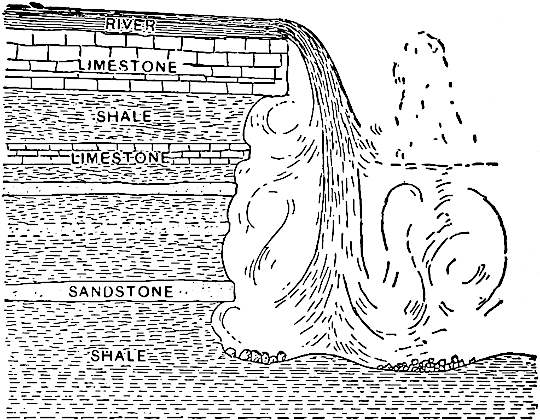
Fig.
113.—Diagram illustrating the conditions which exist at Niagara Falls. (Gilbert.)
If the hard layer which occasions a fall dips up-stream (Fig. 112), its outcrop in the stream’s bed becomes lower as the fall recedes (e). When it has become so low that the water passing over it no longer reacts effectively against the less resistant material beneath (f), sapping ceases, and the point of greatest erosion may be shifted from the soft material beneath the fall to the hard layer itself. The actual rate of erosion at this point may be no greater than before, though the relative rate is. Under these circumstances the vertical edge of the hard layer will presently be converted into an incline (f), and as this takes place the fall becomes rapids. The conversion of the falls into the rapids begins about the time the lower edge of the hard stratum in the channel reaches grade. By continuation of the process which transformed the falls into rapids, the rapids become less rapid, and when the upper edge of the hard layer has been brought to grade, the rapids disappear (h, Fig. 112). The history of rapids which succeed falls is the reverse of that which preceded. The later rapids are steepest at the beginning of their history, the earlier at their end. Stated in other terms, rapids are steepest when nearest falls in time. Slight differences in hardness in successive layers often occasion successive falls or rapids (Fig. 114).
If the hard layer which occasions the falls be horizontal, instead of dipping up-stream, the general result would be the same; but, other things being equal, the duration of the falls developed under these conditions would be greater, since they must recede farther before becoming rapids.
If the layers of unequal hardness in a stream’s bed be vertical and the course of the stream at right angles to the strike, rapids, and perhaps falls, will develop (Fig. 115). The chances for falls are greater, the greater the difference in hardness. Falls developed under these conditions, as well as the rapids preceding and following, would remain constant in position until the resistant layer was brought to grade, but they would ultimately disappear as in the preceding cases. Falls are not likely to develop where the strata of the stream’s bed dip down-stream, though they may develop even under these conditions if the gradient of the stream is greater than the dip of the strata (Fig. 116).
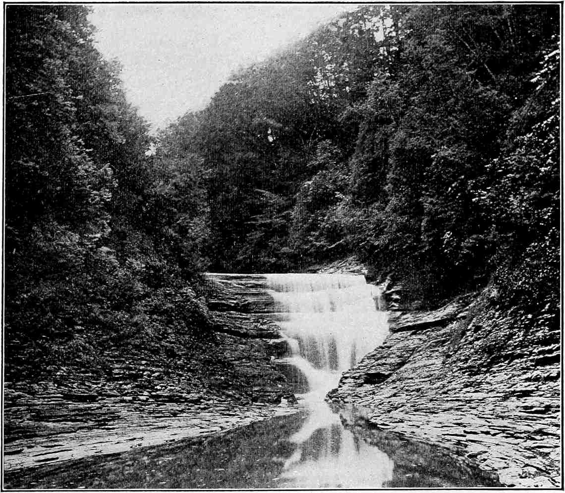
Fig.
114.—Falls in Utica shale, Canajoharie,
N. Y.
(Darton,
U. S. Geol. Surv.
)
The inequality of resistance in the rock which occasions a fall may be original or secondary. In the case of Niagara Falls[50] (Fig. 113) relatively resistant limestone overlies relatively weak shale. At the Falls of St. Anthony (Minneapolis) limestone overlies friable sandstone. The falls of the Yellowstone and the Shoshone Falls of the Snake River (Idaho), are in igneous rock. In the former case the unequal resistance is occasioned by unequal decay of the rock, due perhaps to the rise of hot vapors which have decomposed the rock along the lines of their ascent; in the latter, a more resistant sort of igneous rock overlies a less resistant.
Structural features, such as jointing, sometimes give rise to falls, or determine their distinctive features (Fig. 117), even where the formations involved are of uniform hardness. A joint plane has the effect of a weak vertical or highly inclined bed. If an open joint is discovered in a stream’s bed, the water enters it. If it finds an outlet below, a channel is worn along the new line of flow, with rapids or falls where the water descends. Rock originally homogeneous may be much fractured in some parts, while it remains unbroken in others. Where a stream passes from the solid to the broken portion rapids, or even falls, may develop.

Fig.
115.—Diagram illustrating the development of falls over a vertical hard layer.

Fig.
116.—Diagram illustrating the possibility of falls where the beds dip down-stream.
Falls may originate in still other ways. If for any reason a stream is forced out of its valley, it may in its flow find entrance to another valley, or to another part of its own valley, over a steep slope. If the structure of the slope favors, a fall may speedily develop. The Falls of St. Anthony are an example, the Mississippi having been turned out of its earlier course by deposits of glacial drift. Again, if an obstruction of any sort, such as a flow of lava, dams a stream, rapids or falls are developed where the water overflows the dam. When a main valley is notably deepened by glaciation the drainage from tributary valleys may fall into it, if the tributaries were not equally deepened. Falls which originated in this way are common in the western mountains of the United States, as well as in most mountain regions recently affected by local glaciers (Fig. 118).
One waterfall often breeds others. Thus where a fall recedes beyond the mouth of a tributary stream, the tributary falls. The Falls of Minnehaha, on a small tributary to the Mississippi, near Minneapolis, may serve as an illustration. In such cases the falls may not develop from rapids. Once in existence, the fall of a tributary follows the same history as that of a main stream.
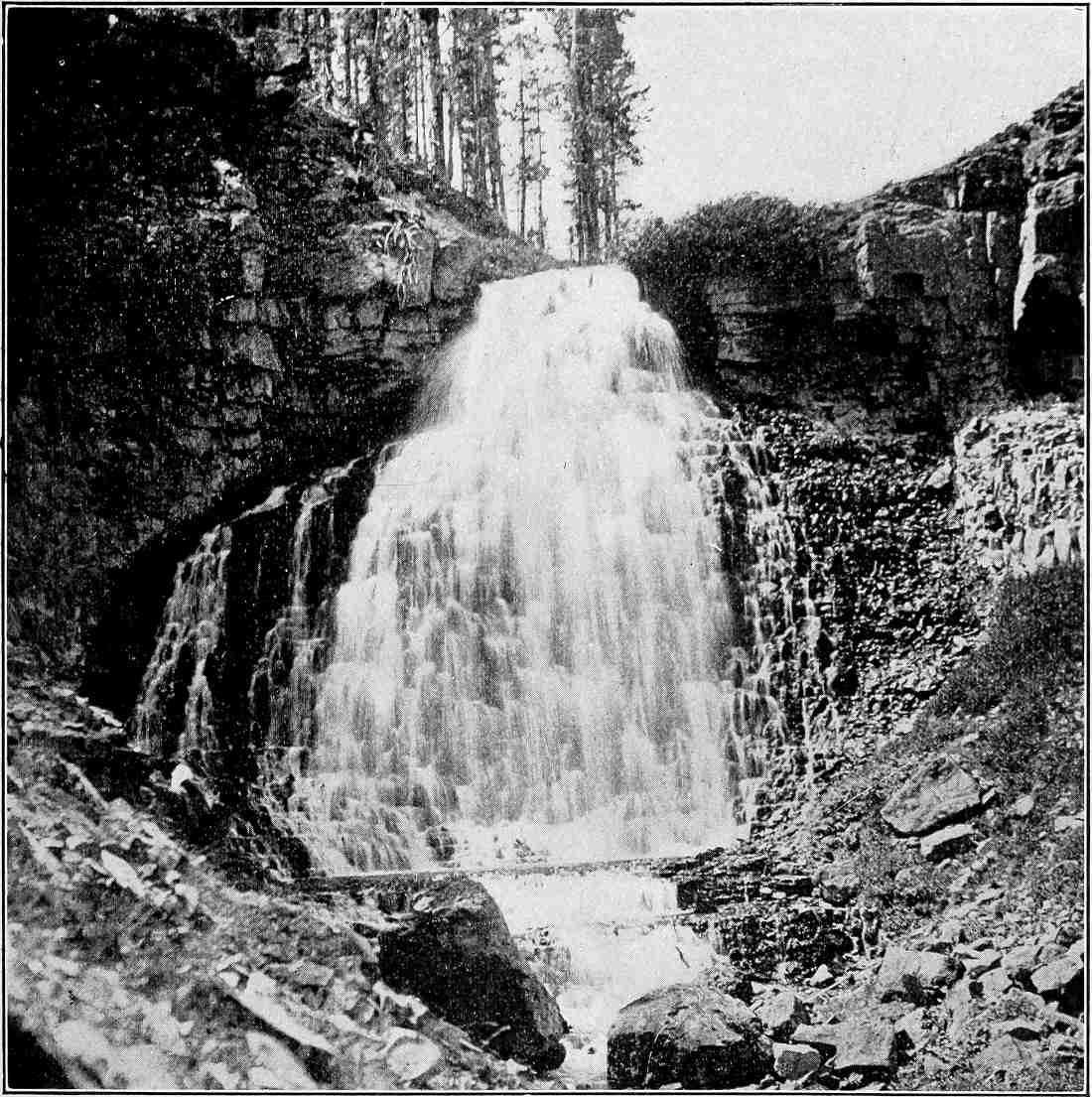
Fig.
117.—Kepler’s Cascade, in the Yellowstone Park. The jointed and fractured character of the igneous rocks occasions a series of falls and rapids. (Iddings,
U. S. Geol. Surv.
)
Streams which have falls are relatively clear.[51] If a stream favorably situated for the development of a fall carried a heavy load, deposition would take place below the rapids, and the tendency would be to aggrade the channel at that point and so to prevent the development of the fall. Falls occur only on streams which have relatively high gradients. This means that the streams which have falls are well above base-level, and streams well above base-level are young. Falls therefore are a mark of topographic youth.
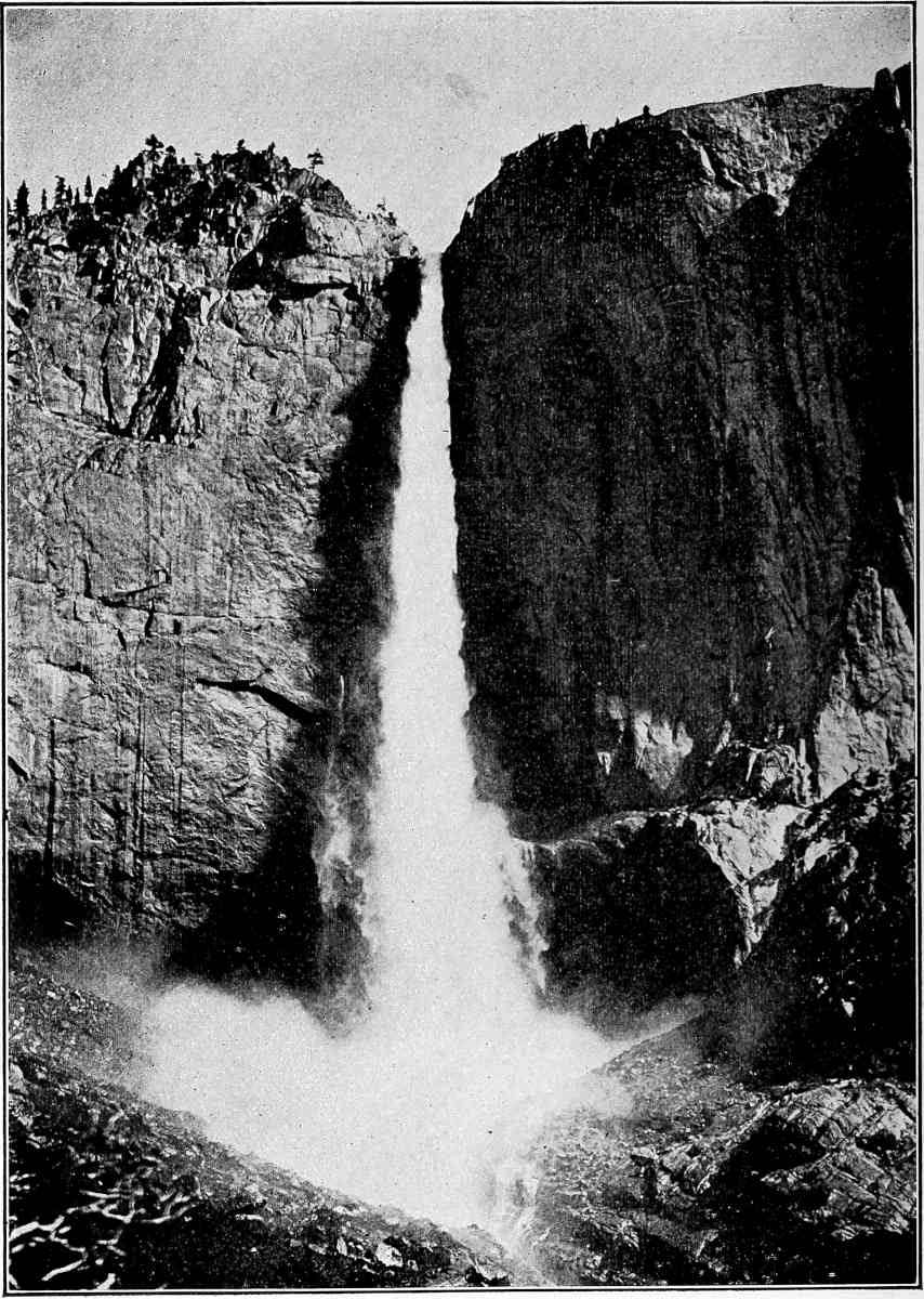
Fig.
118.—The Upper Yosemite Falls.
The fall of the Niagara[52] (Pl. IX) is one of the most remarkable known, both because of its large volume of water and its great descent, between 160 and 170 feet. The rate at which the fall is receding is a matter of interest not only in itself, but because, once determined, it may be made to serve as a unit of measurement for certain important events in geological history. It was formerly conjectured that this fall was receding at the rate of one to three feet per century, but it was not until recent years that its actual rate of recession was approximately fixed. By surveys executed in 1842 and 1890 it has been determined that its average rate of recession between those dates was something like 4½ feet per year, or about 150 times as great as the highest estimate stated above. It is to be noted that this is the average rate of recession, for all parts of the ledge over which the water falls are not receding at the same rate. The point of the “Horseshoe” has, during the same time, gone back at more than twice this rate.[53]
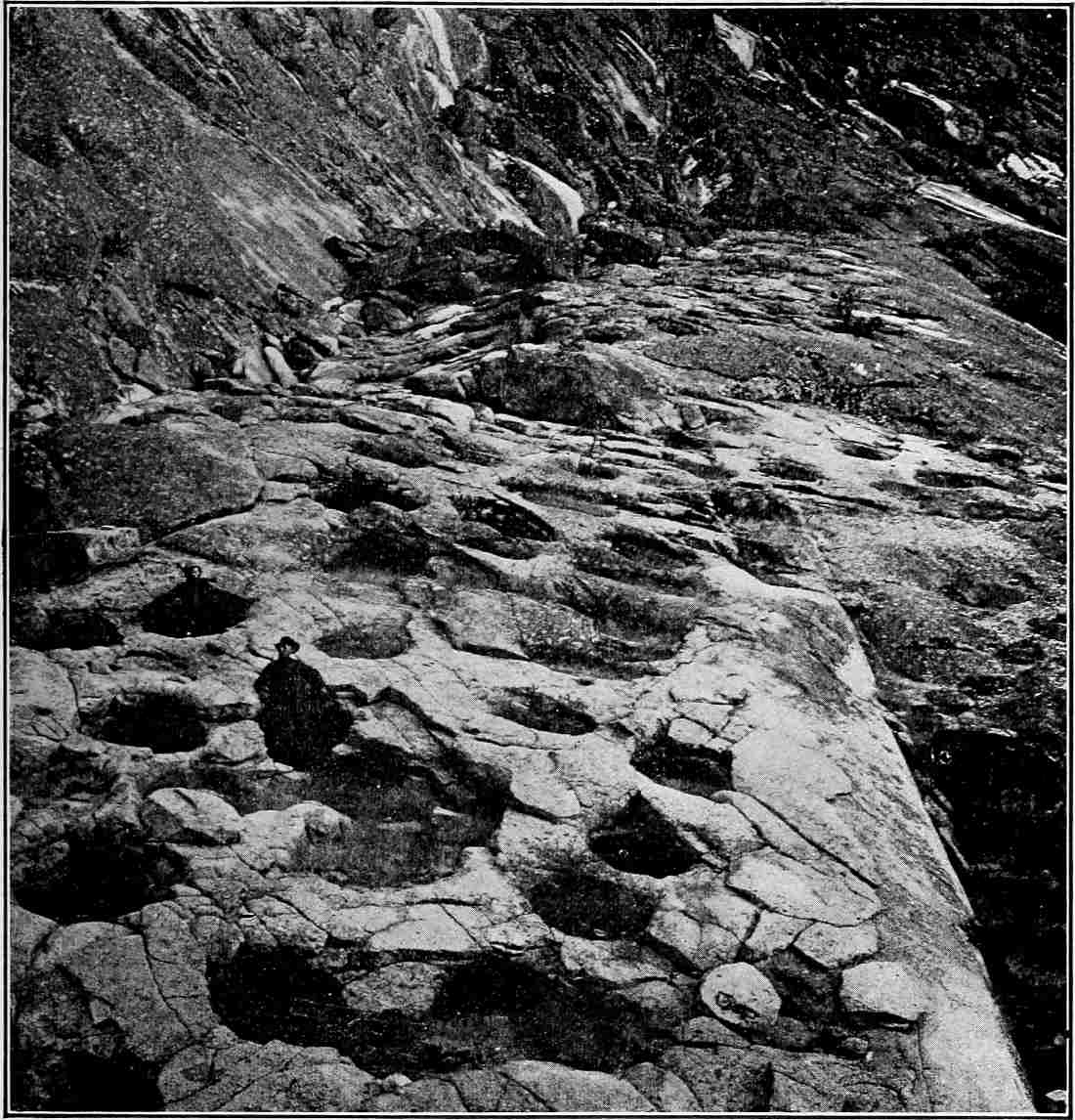
Fig.
119.—A group of pot-holes. (Turner,
U. S. Geol. Surv.
)
Rapids and falls sometimes occasion the development of pot-holes (Fig. 119), a peculiar rather than important erosion feature. The holes are excavated in part by the falling and eddying of silt-charged water, but chiefly by stones which the eddies move. Pot-holes which are not now in immediate association with rapids or falls often point to the former existence of rapids or falls.
Rock terraces.—The tendency to sapping shown in many waterfalls is also shown in the weathering and erosion of the sides of a valley where a hard layer outcrops above the bottom, and the profile of the side slopes of the valley simulates that of the stream; that is, the slope becomes gentle just above the hard layer, and steep, or even vertical, at and below its outcrop. This is illustrated by Fig. 120, where the hard layer through which the stream has sunk its valley stands out as a rock terrace on either side of the valley. Such terraces are not rare and are popularly believed to be old “water-lines”; that is, to represent the height at which the water once stood. In one sense this interpretation is correct, since a river has stood at all levels between that of the surface in which its valley started, and its present channel, but the shelf of hard rock does not mean that the river, after attaining its present channel, was ever so large as to fill the valley to the level of the terrace. Rock terraces may also result from changes of level.
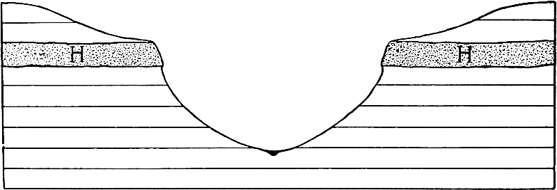
Fig.
120.—Diagram to illustrate the development of rock terraces.
Narrows.—Inequalities in hardness occasion another peculiarity common to valleys. If a stream crosses vertical or highly inclined strata of unequal hardness, its valley is usually constricted at the crossing of the harder layers. If such a constriction be notable it is called a narrows, or sometimes a water-gap (Figs. 121, 159, and Fig. 2, Pl. XII). The Appalachian Mountains afford numerous examples. The constriction arises because the processes which widen the valley are less effective on the hard layer than on the less resistant ones on either hand. Though most narrows are due to the superior resistance of the rock where they occur, they are sometimes the result of other causes.
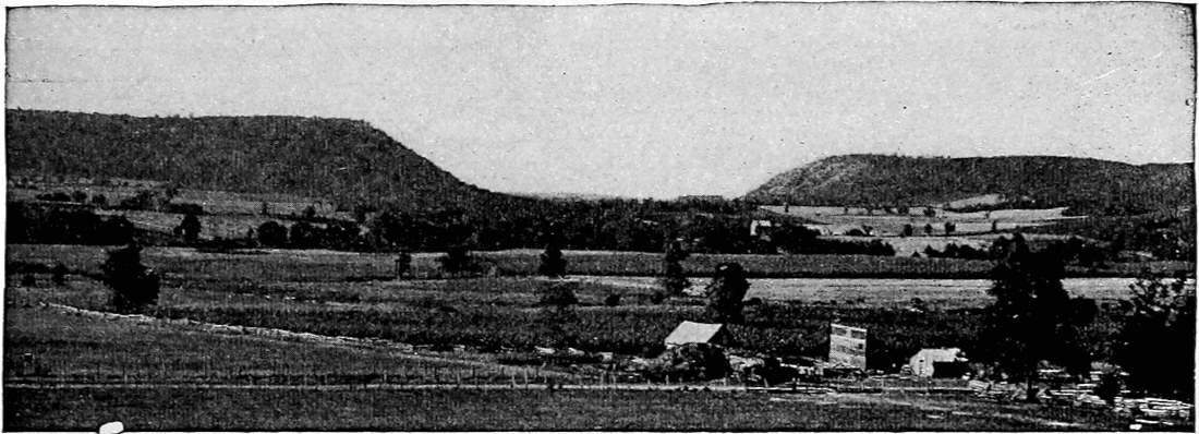
Fig.
121.—Lower narrows of the Baraboo River,
Wis.
The even-crested ridge is Huronian quartzite. The surroundings are of Cambrian sandstone. (Atwood.)
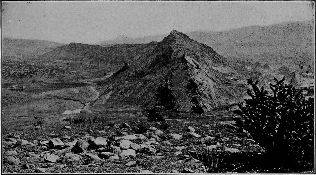
Fig.
122.—A hog-back, Jura-Trias. Colorado City,
Colo.
(Russell,
U. S. Geol. Surv.
)
Narrows are much more conspicuous in certain stages of erosion than in others. While a valley is still so young as to be narrow at all points, no narrows will be conspicuous; but at a later stage in its history, when the valley is otherwise wide, narrows are more pronounced. At a still later stage, when the hard strata themselves approach base-level, the narrows again become inconspicuous.
From what has preceded it is clear that rapids or falls are likely to occur at narrows, especially in the early part of their history.
Other effects on topography.—Inequalities in the hardness of rock develop certain peculiarities of topography other than those of valleys. The less resistant portions of a land area more or less distant from streams are worn down more readily than those which are more resistant. If great areas of high land be capped with hard rock they are likely to remain as plateaus after surrounding areas of less resistance are brought low. If the hard capping affects a small area instead of a large one, the elevation is a butte, a hill, or a mountain, instead of a plateau (Fig. 110). Many buttes and small mesas are but remnants of former plateaus (Mesa Lauriano, N. M., Fig. 1, Pl. XII). A feature of buttes and mesas capped by hard rock is the steep slope or cliff corresponding to the edge of the hard bed (Figs. 78 and 109).
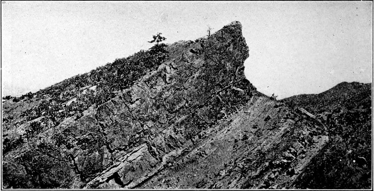
Fig.
123.—A ridge due to the outcropping edge of hard Jurassic rock. Wyoming.
If the rock of a region be stratified and the layers tilted, the removal of the softer beds leaves the harder ones projecting above the general level in the form of ridges or “hog-backs” (Figs. 122 and 123). Dikes of igneous rock, harder than the beds which they intersect, likewise become ridges after the degradation of their surroundings. The plugs of old volcanic vents and other igneous intrusions of limited area often constitute conspicuous hills or mountains after erosion has removed their less resistant surroundings (Fig. 124). Inequalities of hardness are therefore responsible for many hills and ridges. In the isolation of the hills and ridges picturesque coves are developed, where the attitude and distribution of the weak and strong rocks are propitious. The bottoms of the coves are located on the weak rocks, and above them rise the precipitous slopes of the resistant ones. Round valley (Fig. 1, Pl. XVII, High Bridge, N. J., quadrangle, U. S. Geol. Surv.) and the coves about the head of Hiawassee River (Dahlonega, Ga., quadrangle) are examples.
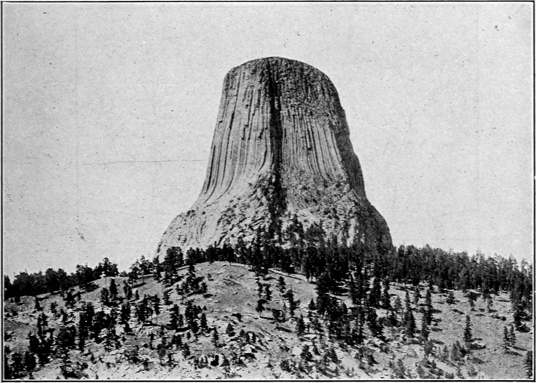
Fig.
124.—Matteo tepee,
Wyo.
Mass of igneous rock exposed by erosion, and preserved because of its superior resistance. (Detroit Photo.
Co.
)
Ridges and hills resulting from the unequal degradation of unequally resistant terranes are not equally prominent at all stages in an erosion cycle. In early youth the material surrounding the hard bodies of rock has not been removed; in early maturity considerable portions of their surroundings still remain about them; but in late maturity or early old age the outcropping masses of hard rock have been more perfectly isolated and are most conspicuous. Most of the even-crested ridges of the Appalachian system, as well as many others which might be mentioned, became ridges in this way. In the final stages of an erosion cycle the ridges of hard rock are themselves brought low. Isolated remnants of hard rock which remain distinctly above their surroundings in the late stages of an erosion cycle (Fig. 124) are known as Monadnocks, the name being derived from Mount Monadnock, N. H., an elevation of this sort developed in a cycle antedating the present.
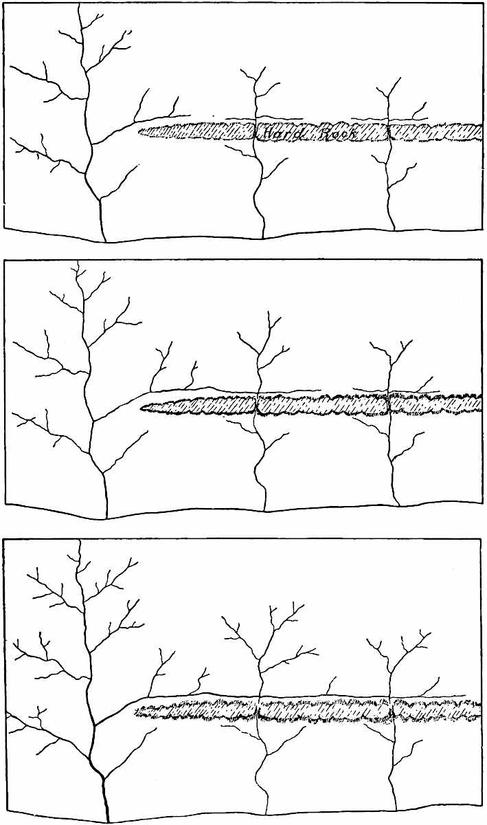
Fig.
125–27.—Diagrams illustrating piracy, where the stream which does not flow over rock of superior hardness captures those which do.
Fig.
126 represents a further development of the drainage shown in
Fig.
125, and
Fig.
127 represents a still later stage.
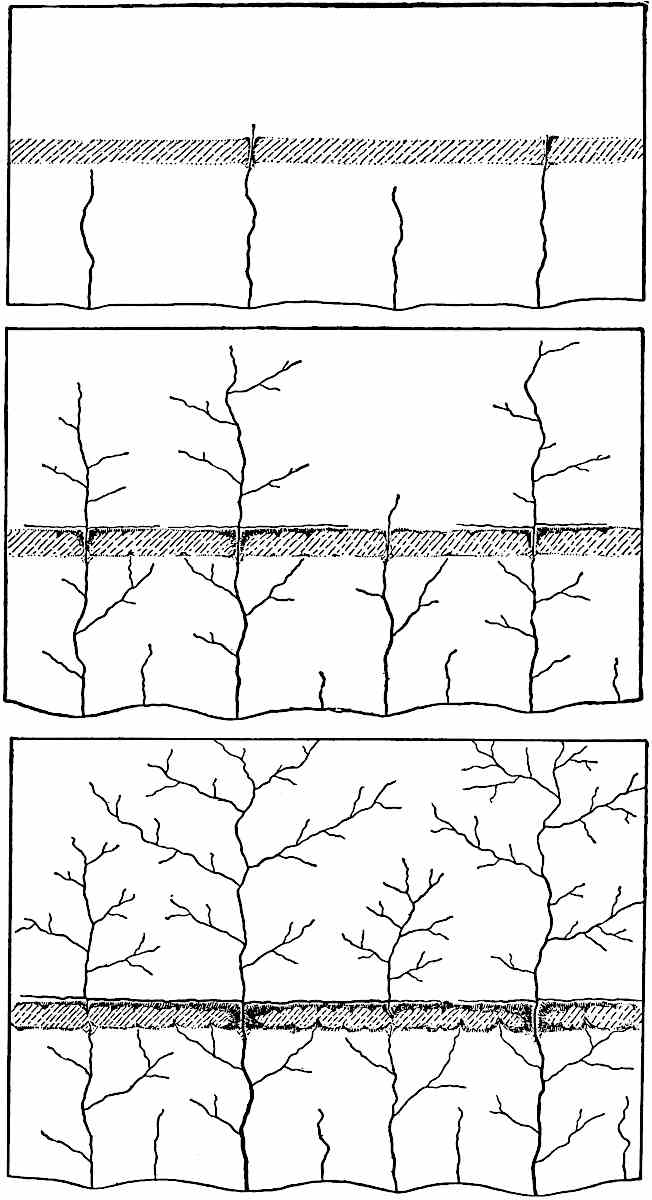
Fig.
128–30.—Diagrams to illustrate piracy, where the competing streams all cross a hard layer. The diagrams represent successive stages of development.
Adjustment of streams to rock structures.—Valleys (gullies) locate themselves at the outset without immediate regard to the hardness and softness of their beds. It is primarily the slope about the head of a gully which determines its line of growth, though relative hardness often determines the details of slope, even in the early stages of an erosion cycle. Once established, streams tend to hold their courses, even if this involves the crossing of resistant layers.
While a region where more and less resistant layers of rock come to the surface is in a youthful stage of erosion, some of the valleys (and therefore the streams) are likely to be located on the less resistant rock, some on the more resistant, and some partly on the one and partly on the other. The streams on the weaker rock will deepen their valleys more rapidly than the others, and those which flow across stronger and weaker rocks alternately will deepen their valleys more rapidly than those which run on hard rock all the time. The former conclusion is self-evident. The latter appears from the fact that rapids will be likely to develop at the crossing of each hard layer, thus accelerating erosion at those points. Such a stream therefore not only has less hard rock to erode than one which flows on resistant rock all the time, but it erodes that which it does cross much faster.
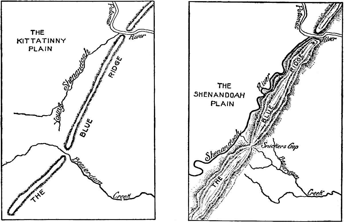
Fig.
131, 132.—The capture of the head of Beaverdam Creek by the Shenandoah
Va.
-
W. Va.
(After Willis.)
Streams which do not cross hard layers therefore have an advantage over those which do, and the tributaries to such streams, since they join deeper mains, have an advantage over the tributaries to the others. The valleys of the former may lengthen until their heads reach the latter, and capture their streams. This sequence of events is illustrated in the accompanying diagrams (Figs. 125–27). Even where several streams cross the same resistant bed, piracy is likely to take place among them, for some are sure to deepen their valleys faster than others, because of inequalities of volume, load, or hardness. This is illustrated by Figs. 128–30. An actual case is shown in Figs. 131, 132. Though piracy may take place when streams do not flow over rock of unequal hardness (p. 103), it is much more common where unequal resistance of the rock puts one stream at a disadvantage as compared with another.
The changes in the courses of streams, by means of which they come to sustain definite and stable relations to the rock structure beneath, are known as processes of adjustment.[54] Since streams and valleys adjust themselves to other conditions as well, this phase of adjustment may be called structural adjustment. Structural adjustment is not uncommon among rivers flowing over strata which are vertical or highly inclined, since in these positions the hard and soft strata are most likely to come to the surface in frequent alternation. The smaller streams suffer capture and adjustment first, since, as a rule, they have shallower valleys. It often happens that main streams, because of their deeper valleys, hold courses not in adjustment with structure (the Delaware, the Susquehanna, etc.), while tributary streams are captured, diverted, and adjusted. The capture of a tributary, however, leads both to the diminution of its main and to the increase of its captor, and the weakened stream may ultimately fall a prey to the one which is strengthened.
The processes of adjustment go on until the streams flow as much as possible on the weaker beds, and as little as possible on the stronger, when adjustment is complete. This amounts to the same thing as saying that the outcrops of the hard layers tend to become divides. In many cases an area is so situated that there is no escape for its drainage except across resistant rock. In this case its drainage is completely adjusted when as few streams as possible cross the resistant rock, and these by the shortest routes.
Adjustment has been carried to a high degree of perfection in most parts of the Appalachian system. Here, as in all other mountains of similar structure, strata of unequal hardness were folded into ridges. In this case, the folds have been truncated by erosion, exposing the more and the less resistant beds (H and S respectively) in alternate belts along the flanks of the truncated folds (ab and cd, Fig. 133). The streams, especially the lesser ones, now flow along the strike of the softer beds much more commonly than elsewhere, and where they cross the hard layers it is usually at right angles to the strike. This is shown in Fig. 134, where the arrows indicate the direction of strike. In the history of these rivers, however, a factor is involved which has not yet been considered, and these streams will be referred to later.
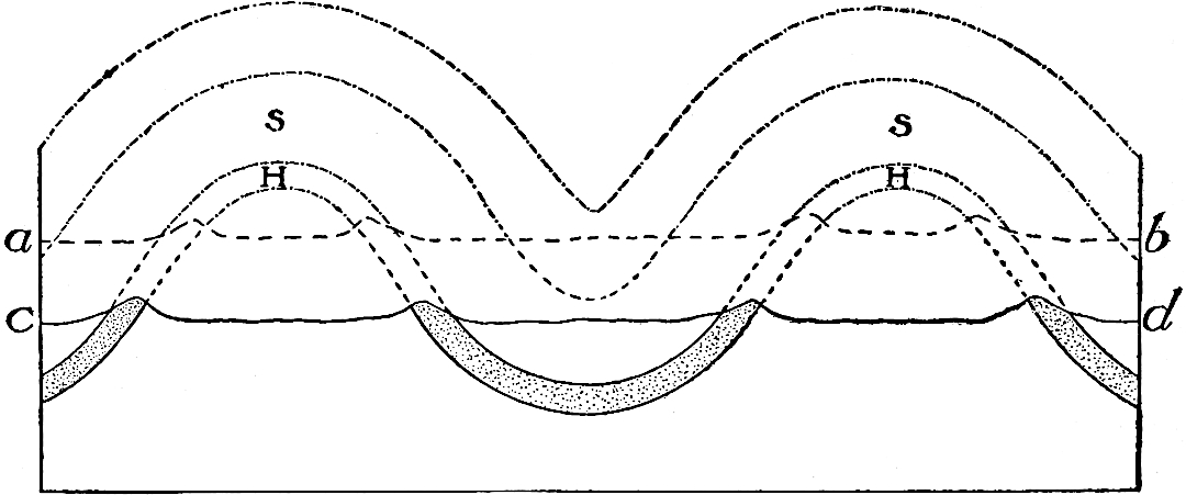
Fig.
133.—Diagram showing the outcrops of hard layers on the flanks of a truncated fold.
cd
represents th/e present surface; dotted lines above, earlier surfaces.
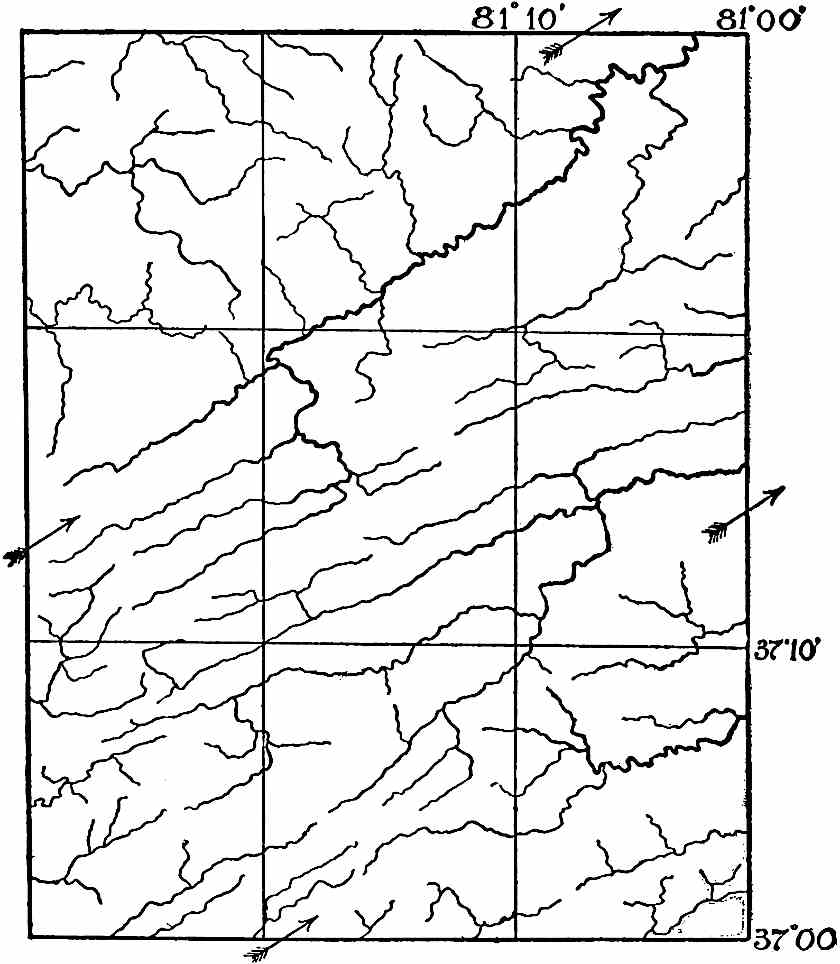
Fig.
134.—Example of adjusted drainage in a region of folded rocks,
Va.
-
W. Va.
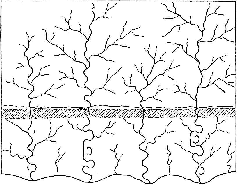
Fig.
135.—Diagram to illustrate readjustment of drainage, as base-level is approached.
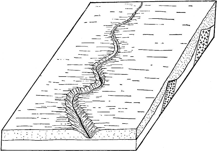
Fig.
136.—Diagram to illustrate superimposition. The consequent stream on the upper formation is superimposed on the underlying structures when the upper bed has been cut through.
As base-level is approached, the outcrops of hard rock are brought low. When they have been reduced to the level of their surroundings, the streams may flow without regard to the resistance of the rock beneath, for downward cutting has ceased. As this stage of erosion is approached, a readjustment of the drainage may take place, and the waters which had taken long and circuitous courses to avoid hard rock, may change their courses to more direct ones (compare Figs. 130 and 135). Adjustment is, therefore, a relative term, and streams which are adjusted at one stage of erosion, are not necessarily adjusted at another.
It sometimes happens that rocks of unequal resistance are covered by beds of uniform hardness. A consequent stream developed on the latter may find itself out of structural adjustment when it has cut its channel down to the level of the heterogeneous beds below. Such a stream is said to be superimposed (Fig. 136) on the underlying structure. Structural adjustment is likely to follow.
INFLUENCE OF JOINTS AND FOLDS.
Joints.—Various structural features of rock other than hardness influence its erosion. Apart from the stratification planes, most rock formations are affected by joints or fissures. The joints are often, but not always, nearly vertical. Two sets are generally present, and sometimes more. If but two, they usually meet at a large angle; if more than two, two are likely to be nearly perpendicular to each other, while the third and fourth sets have such directions as to cut the others at large angles. These joints allow the ingress of water, roots, etc., which help to weather and disrupt rocks. Occasionally there is notable sag of the beds of rock along joint planes, but this effect is usually superficial only (Fig. 137). Where the jointage planes are frequent and open, the columns bounded by them sometimes topple over on cliff faces, either by undercutting, or by the wedge-work of roots or ice.
The effect of joints on erosion may often be seen along a stream which flows in a rock gorge. In such situations, the outlines of the banks are sometimes angular, and sometimes crenate (Fig. 138), the reëntrants being located at the joints. By working into and widening joints, running water sometimes isolates masses of rock as islands (Fig. 139). In a region free from mantle rock, or where the mantle rock is meagre, joints often determine the courses of valleys by directing the course of surface drainage. This is shown in many parts of the arid west. In regions where the rocks are notably faulted, the courses of the streams are sometimes controlled by the courses of the fault planes. This is the case, for example, in central Washington.[55]
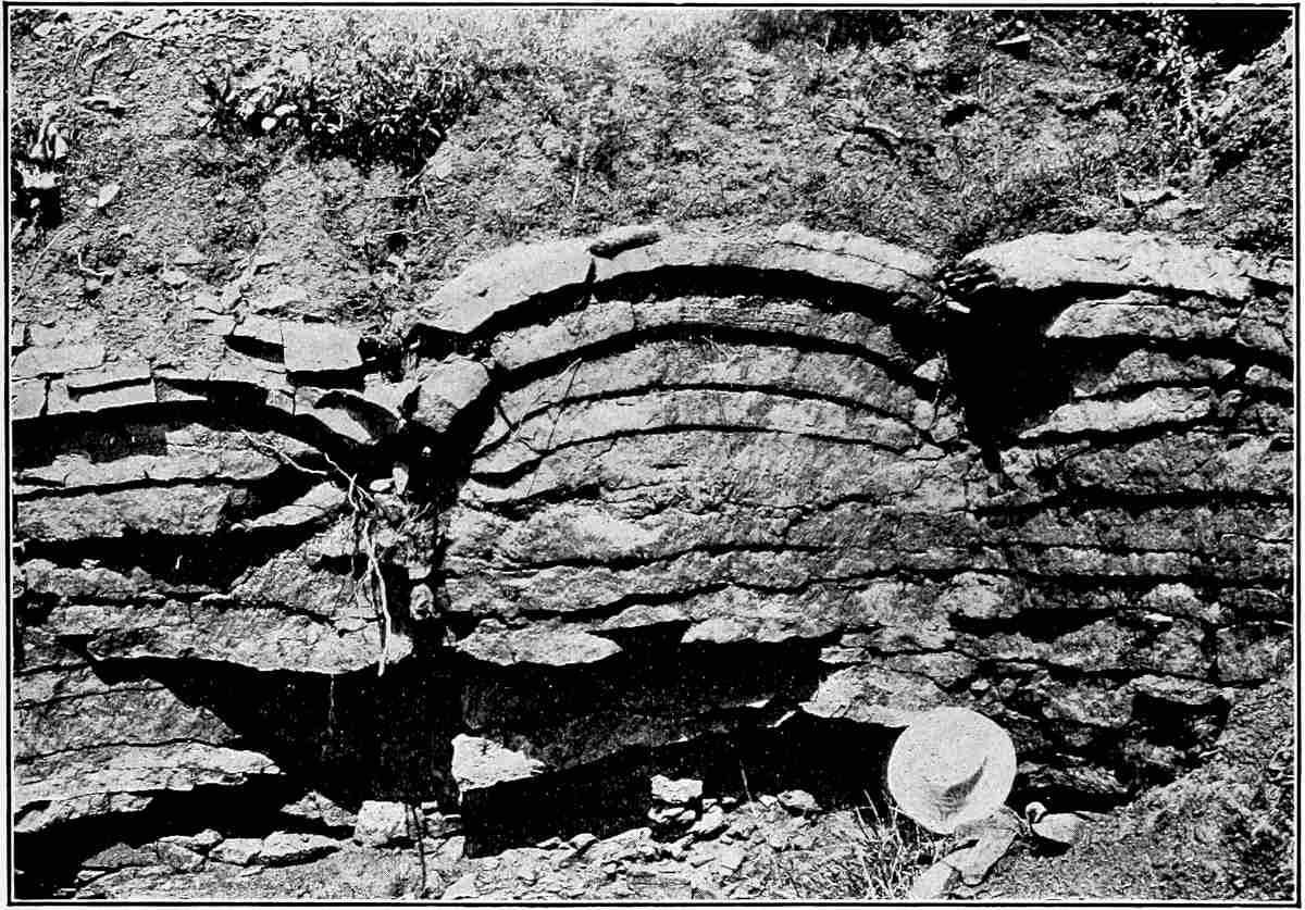
Fig.
137.—Shows the sagging of beds along joints. The disturbance does not extend far below the surface. Cook’s quarry (Niagara limestone) near La Salle, Niagara
Co.
,
N. Y.
(Gilbert,
U. S. Geol. Surv.
)
The jointing of rocks often shows itself distinctly in the weathered faces of cliffs (Figs. 140 and 141), especially in arid and semi-arid regions, or where the slope is too steep for the accumulation of soil and rock-waste on its surface.
If a stream flowing over jointed rock has falls, the conditions are sometimes afforded for the development of an exceptional and striking scenic feature. If above Niagara Falls, for example, there were an open joint in the bed of the stream (as at b, Fig. 142), some portion of the water would descend through it. After reaching a lower level it might find or make a passage through the rock to the river below the falls. If even a little water took such a course, the flow would enlarge its channel, making a passageway between the joint through which the water descended and the valley below the falls (bcde, Fig. 142). This passageway might become large enough to accommodate all the water of the river. In this case, the entire fall would be transferred from the position which it previously occupied (f) to the position of the enlarged joint (b). The fall would then recede. The underground channel between the old falls and the new would be bridged by rock (bf″ and f‴, Fig. 143), making a natural bridge. The natural bridge near Lexington, Va. (Fig. 144), almost 200 feet above the stream which flows beneath it, is believed to have been developed in this way. A similar bridge is now in process of development in Two Medicine River in northwestern Montana (Fig. 145). Once in existence, a natural bridge will slowly weather away.
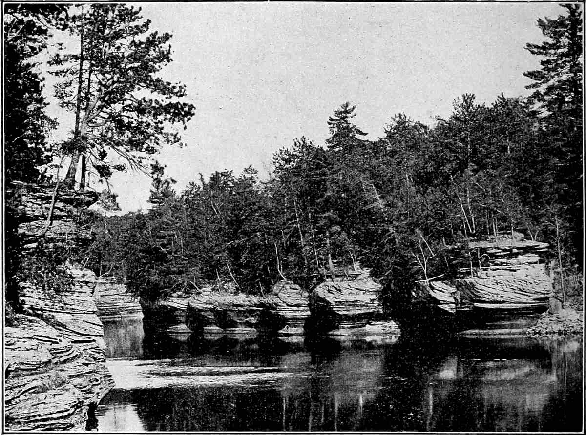
Fig.
138.—Figure showing crenate river bank, the reëntrants being determined by joints. Dells of the Wisconsin River, near Kilbourn,
Wis.
(Atwood.)
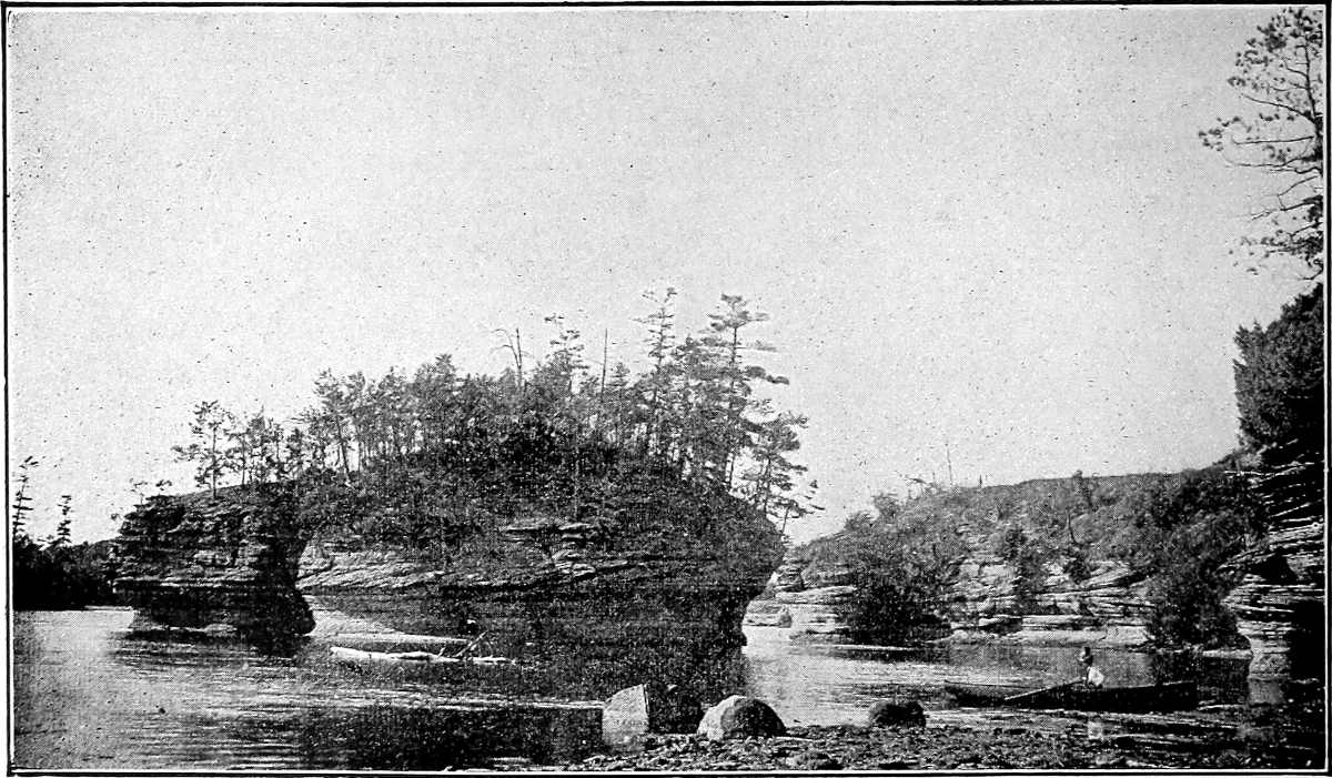
Fig.
139.—Lone Rock. An island isolated by the notable widening of a series of joints. The joints in the rock of the island have themselves been so widened that a rowboat may be taken through it in two directions. Lower Dells of the Wisconsin. (Meyers.)
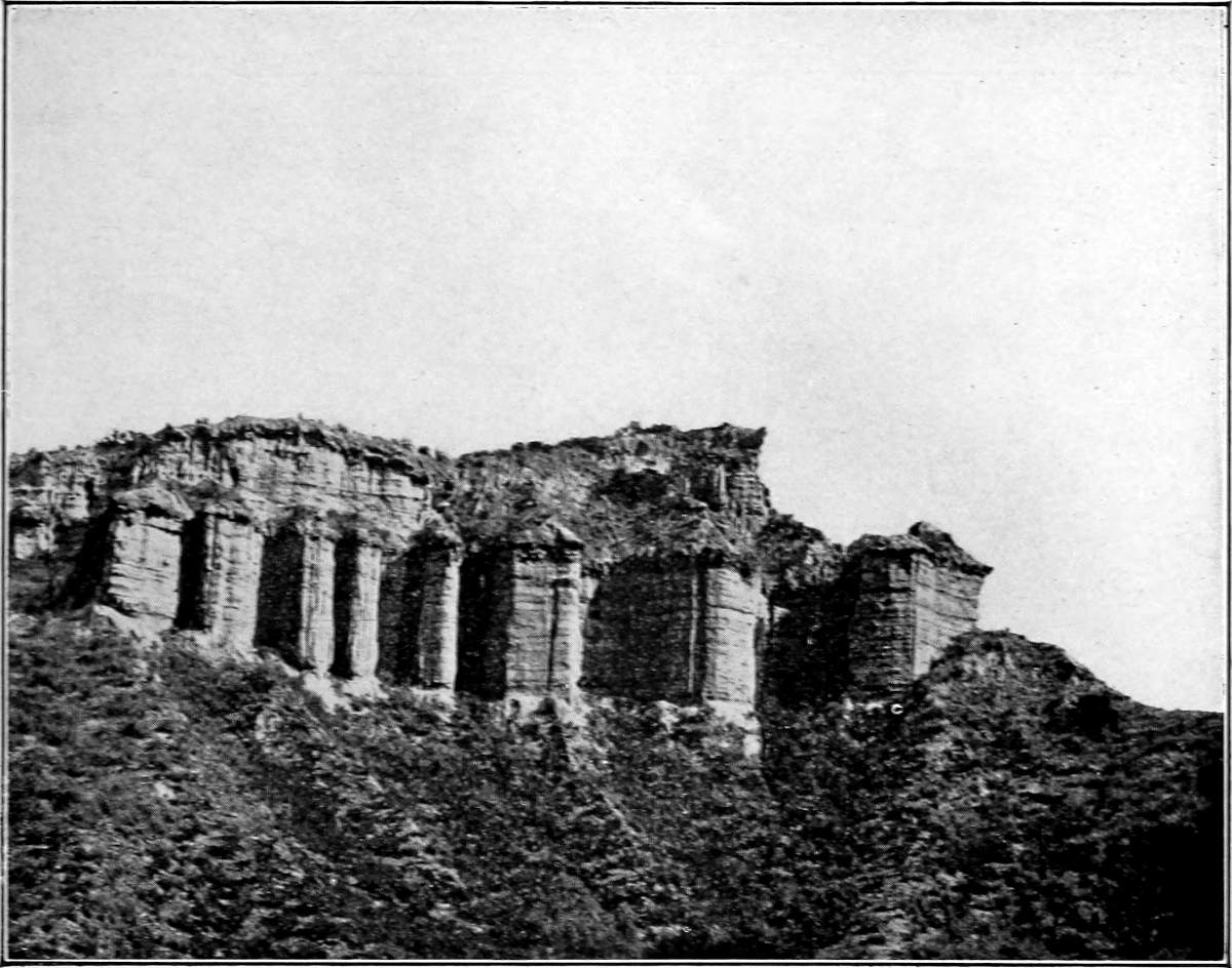
Fig.
140.—Effect of columnar structure on weathering. Material unconsolidated. Spur of south end of Sheep Mountain. (Lippincott,
U. S. Geol. Surv.
)
It is not to be understood that all natural bridges have had this history. They are sometimes developed from underground caves when parts of their roofs are destroyed, as well as in various other ways.
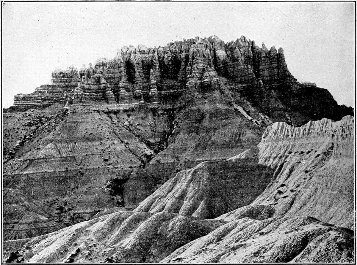
Fig.
141.—Effect of columnar structure on weathering. Big Bad Lands,
S. D.
(Darton,
U. S. Geol. Surv.
)
Folds.—The erosion of folded strata (anticlines and synclines) leads to the development of distinctive topographic features. So soon as a fold begins to be lifted, it is, by reason of its position, subject to more rapid erosion than its surroundings. For the same reason the crest of the fold is likely to be degraded more rapidly than its lower slopes, and must suffer more degradation before it is brought to base-level. Folds are usually composed of beds of unequal resistance, and as the degradation of a fold proceeds, successive layers are worn from the top, and the alternating hard and soft layers composing it are exposed. So soon as this is accomplished, adjustment of the streams is likely to begin, and the watercourses, and later the valley plains, come to be located on the outcrops of the less resistant layers, while the outcrops of the harder beds become ridges.
If the axis of an eroded anticline were horizontal, a given hard layer, the arch of which has been cut off, would, after erosion, outcrop on both sides of the axis. When the topography was mature these outcrops would constitute parallel ridges, or parallel lines of hills; when the region had been base-leveled, the outcrops would be in parallel belts, though no longer ridges or hills. The lower the plane of truncation, the farther apart would the outcrops be in the anticline, and the nearer together in the syncline (compare ab and cd, Fig. 133).

Fig.
142.—A natural bridge in process of development; longitudinal section at the left; transverse section, looking toward
e
, at the right.

Fig.
143.—The same as
Fig.
142
at a later stage of development.
If, on the other hand, the axis of the anticline or syncline to be eroded was not horizontal, that is, if it plunged, the topographic result would be somewhat different. Suppose a plunging anticline to be truncated at base-level. If either end of the fold plunged below the plane of truncation, the outcrops of a given layer on opposite sides of the axis would converge in the direction of plunge, and come together at the end. At a stage of erosion antedating planation (say late maturity) there would have been a ridge, or a succession of hills, in the position corresponding to the outcrop of a hard layer, with a canoe-shaped valley within. If two hard layers were involved, instead of one, there would be two encircling ridges, with a curved valley between them, and a canoe-shaped valley within the innermost (Fig. 146). If the anticline plunged both ways, the valley enclosed by the hard-layer ridge would be canoe-shaped at both ends (Fig. 147). In such a case there would be likely to be a low gap (water-gap) in the rim of the valley through which the drainage which degraded the surface escaped, but there would be likely to be but one, for if two or more streams had drained the area of the valley at an early stage of erosion, one would be likely to have captured the others (see p. 138) before late maturity. A succession of doubly-plunging anticlines and synclines might give rise to a very complex series of ridges and valleys. Illustrations of the above phenomena are found at various points in the Appalachian Mountains, especially in eastern Pennsylvania.[56]
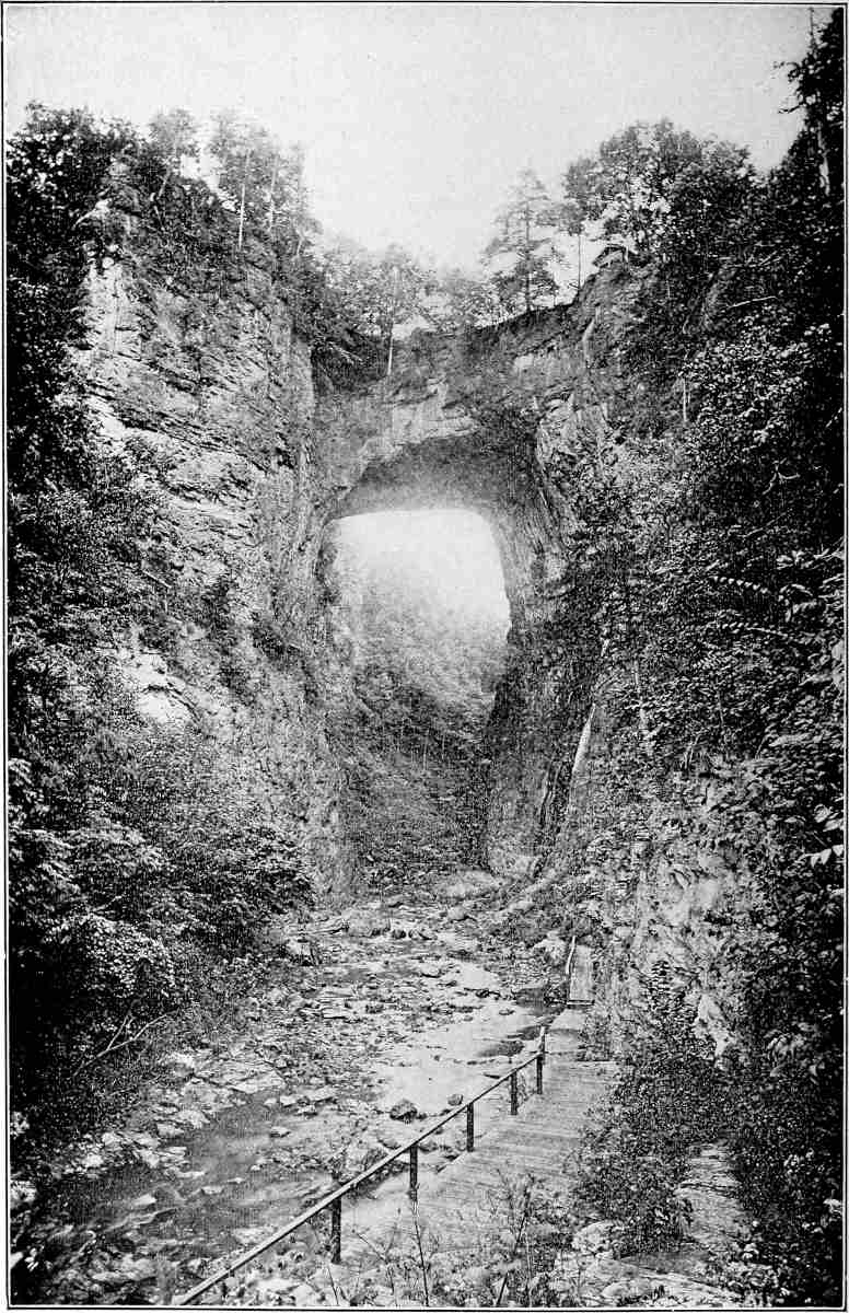
Fig.
144.—The Natural Bridge of Virginia, from the southeast (Walcott,
U. S. Geol. Surv.
)
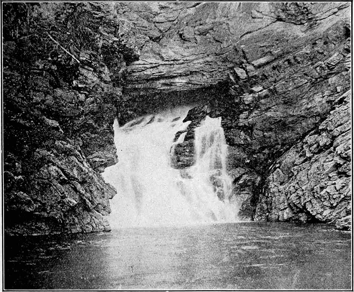
Fig.
145.—A natural bridge in development. Two Medicine River,
Mont.
Corresponds to the stage represented by
Fig.
142
, and the view corresponds to that shown diagrammatically at the right-hand end of the figure. (Whitney.)
In the structural adjustment which goes with the erosion of folds, it often happens that the valleys come to be located on the anticlines, while the outcrops of the hard layers on the flanks of the anticlines, or even in the original synclines, become the mountains. The adjustments by which valleys come to be located on anticlines are somewhat as follows:[57] Fig. 148 represents two doubly-plunging anticlines with a syncline between, the relative elevations being shown by contour lines. At the outset, the drainage of such a region must have followed the structural valley, and its initial course, consequent on the slope, must have been down the axial trough. Drainage from the anticlines into the synclines would have promptly developed valleys, and the valleys would soon have acquired streams.
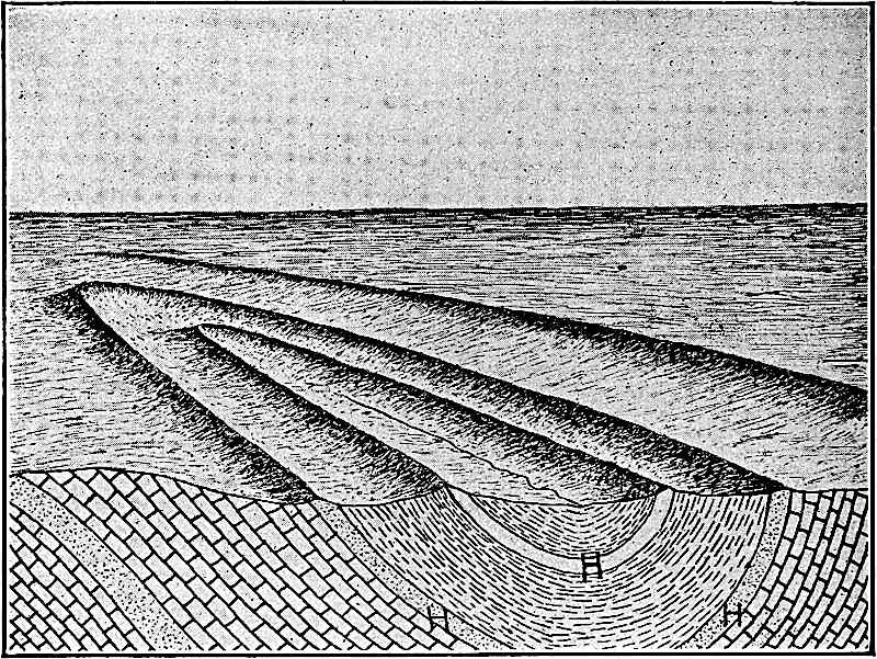
Fig.
146.—A canoe-shaped valley bordered by a ridge formed by the outcrop of a hard layer in a plunging syncline. The ridge bounding the canoe-valley is separated from an outer ridge by a curved valley underlain by relatively weak rock. (After Willis.)
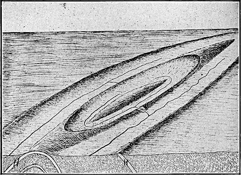
Fig.
147.—A diagram to illustrate the effects of erosion on a doubly-plunging anticline made up of beds of unequal hardness.
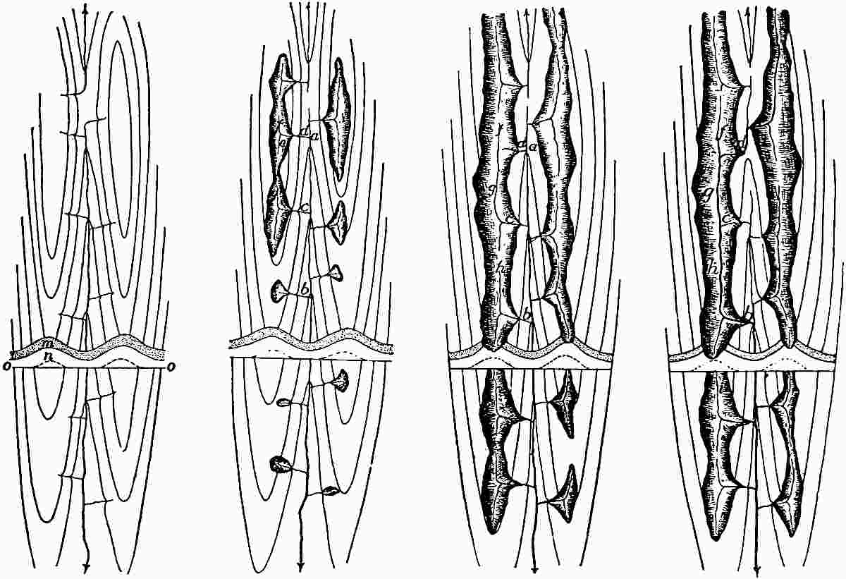
Fig.
148–51.—Diagrams to illustrate the shifting of rivers from a synclinal to an anticlinal position. (After Davis.)
The anticlines and synclines under consideration are assumed to have a thick hard layer at the surface, and softer beds below. This is shown in the cross-section introduced in the figure, the upper hard stratum (m) being indicated by the dots, while the softer one (n) is white. The line oo represents base-level, which is below the hard layer both in the syncline and anticline, but much farther below in the latter position than in the former. Because of their higher gradients, and because of the greater fracturing to which the region they drain was presumably subject at the time of folding, the tributary streams might cut through the hard layer sooner than the main stream which they join. This done, they would enlarge their valleys rapidly in the softer rock beneath, and secondary tributaries would be developed (Fig. 149). When the condition of things represented in Fig. 149 is reached, the streams c and d, tributary to the synclinal stream, come into competition. The former has the advantage over the latter, because it joins the main stream at a lower level. Stream c will therefore be likely to capture d. The incipient stages of the capture are stealthy, and the later bold. At first the divide between their head waters is shifted northward inch by inch, because the gradient toward g is higher than that toward e. The capture of the head waters of e is as slow as the migration of the divide, until the divide reaches the point where e joins f. The stream f is then diverted promptly into the valley of g, and is at once led away to c (see Fig. 150). Strengthened by its increased volume, the stream c (Fig. 150) lowers its valley across the hard layer more rapidly than before, and so holds the advantage it has gained. Not only this, but the beheaded stream d (Fig. 150), because of its diminished volume, sinks its valley into the hard layer less rapidly than before, and its decrease in power also works to the advantage of the stream leading to c. The result is that the divide between fg and d does not remain constant, but is driven back step by step toward a.
Similarly a tributary to the main stream at b (Fig. 150), may by means of its tributary h, capture the waters of fg, and lead them to the synclinal valley at b (compare Figs. 150 and 151). Deprived of its main source of supply (at c) the synclinal stream is greatly diminished above b, and cuts more and more slowly, while the stream fgh (Fig. 151), having greater volume and working mainly in softer rock, sinks its channel faster than the stream in the synclinal axis. Under these circumstances, the stream at f may cut its valley below the valley in the synclinal axis a (Fig. 150). In this event, the divide between f and a (Fig. 150) may be pushed back until the synclinal stream is beheaded at a and carried out of the syncline and over into the anticlinal valley (Fig. 151). Thus, the old anticlinal axis comes to be the course of the main stream. Similarly the stream entering the syncline at b (Fig. 151) might later be captured by i, thus lengthening its anticlinal course.
It is not to be understood that this sequence of events will take place in the degradation of every anticline, but the principles here set forth will always be operative. The result specified will be accomplished wherever hard and soft layers have the relations indicated in the diagrams; that is, where the stream in the syncline finds itself on a resistant layer as it approaches base-level, while at the same time the (original) tributary streams are working in softer beds. It is not to be understood, therefore, that streams migrate from synclines to anticlines for the sake of getting out of the former positions into the latter. If they shift their courses it is to find easier ones.
That these changes are not fanciful is shown by the fact that the adjustment described corresponds with that shown in many parts of the Appalachian Mountains, and in other mountains of similar structure.
If in a later stage of its history, the new main stream, fh, were to cut its bed down to a lower hard layer, while the original stream, ab, reached a softer bed beneath the hard one above, the latter would again have an advantage, and a new series of adjustments would be inaugurated which might result in re-establishing the main stream in its original synclinal position.
EFFECT OF CHANGES OF LEVEL.
Rise.—If after being base-leveled, or notably reduced by erosion, a region is uplifted so as to increase the gradients and therefore the velocities of the streams which drain it, the streams are said to be rejuvenated, and a new cycle of erosion is begun. If the rise of the area were equal everywhere, while the coast line remained constant in position, there would be an immediate increase in velocity only at the debouchures of the streams flowing directly into the sea. At the debouchures of such streams there would be rapids or falls. Each rapids or falls would promptly recede, and with the recession, the acceleration of velocity resulting from the uplift would be felt farther and farther up-stream, and ultimately to its source. The rejuvenated streams would cut new valleys in the bottoms of their old ones (Figs. 152 and 153). The new valleys would begin where the increase in velocity was first felt, and they would be lengthened by head erosion just as valleys of the first cycle were lengthened.
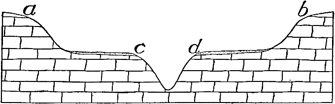
Fig.
152.—Cross-section of a wide valley,
ab
, in the bottom of which a younger valley,
cd
, has been excavated as the result of uplift.
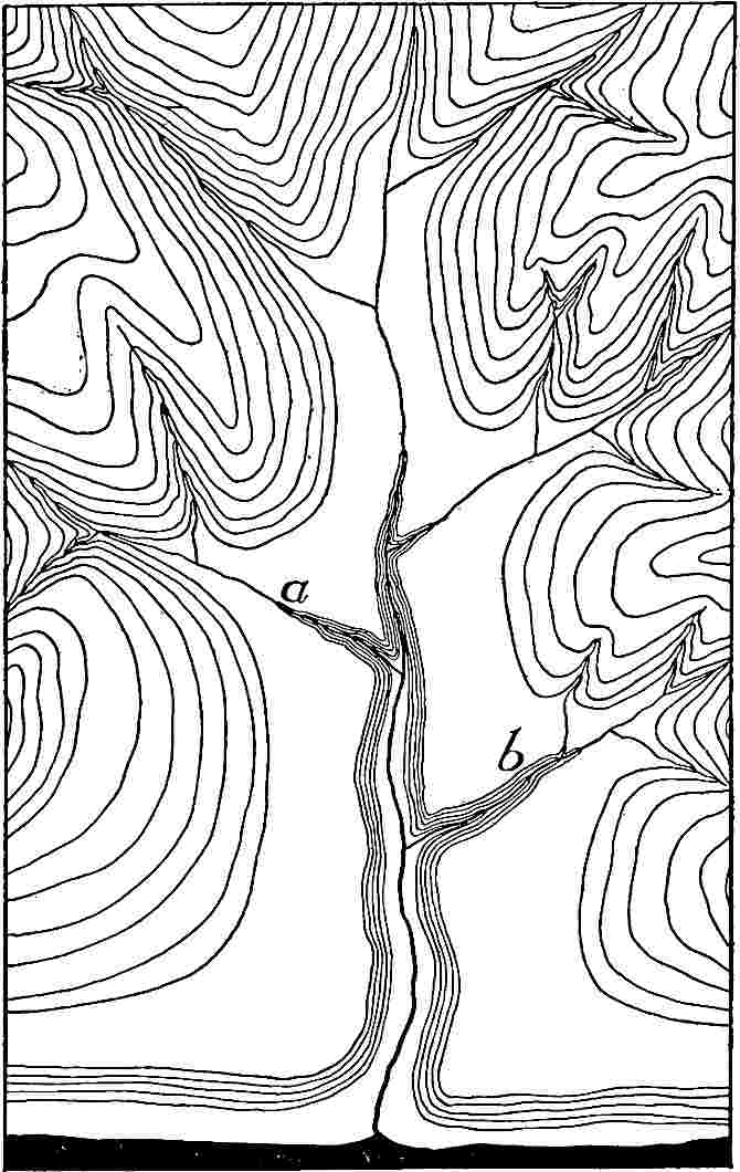
Fig.
153.—Diagram to illustrate in ground plan an ideal case of rejuvenation as the result of uplift.
When the head of the new part of a valley of a rejuvenated stream recedes past the mouth of a tributary adjusted[58] to the gradient of the main stream before rejuvenation, the velocity of the tributary is accelerated at its debouchure, and it begins to excavate a new valley in the bottom of its old one. The new valley commences at the lower end of the old one, and develops headward (a and b, Fig. 153). Good illustrations are furnished by the streams in the west central part of New Jersey. The Delaware has here a sharply defined valley, and its tributaries are essentially as deep as their main at the point of junction. Above this point they have high gradients for a short distance (three to six miles), beyond which they wind sluggishly in wide valleys with low gradients across a relatively high plateau. Their profiles are illustrated by Fig. 154. The flat, though high, surface in which their upper courses lie, appears to have been nearly base-leveled in an earlier cycle, and then to have been elevated. The date of the elevation is fixed, in terms of erosion, by the time necessary for the excavation of the Delaware gorge, and the narrow gorges along the lower courses of its tributaries. It was so recent that the effects of rejuvenation, proceeding from the debouchures of the tributaries toward their heads, have not yet advanced far from the Delaware. Similar relations are found elsewhere (Fig. 1, Pl. XIII, s. c. Col.). Another peculiarity of rejuvenated drainage is shown in Fig. 2, Plate XIII (s. Kan.). Here Elm Creek flows at a level 200 feet below that of Sand Creek, 4 miles distant. The valley of the former appears to have entered upon a new cycle as the result of uplift, while that of the latter, in the area shown on the map, is still unrejuvenated. Farther down-stream, the valley of Sand Creek shows signs of rejuvenation. It may be noted that a tributary of Amber Creek has good opportunity to capture Sand Creek, for the latter flows about 25 miles before reaching the level of Amber Creek at its junction with Elm Creek.
PLATE XIII.
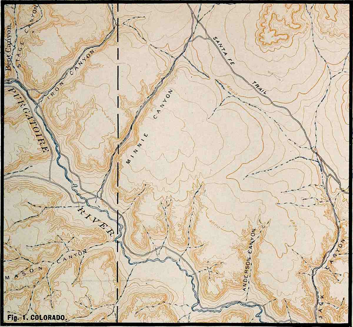
U. S. Geol. Surv.
Scale, 2+ mile per inch.
Fig.
1. COLORADO.
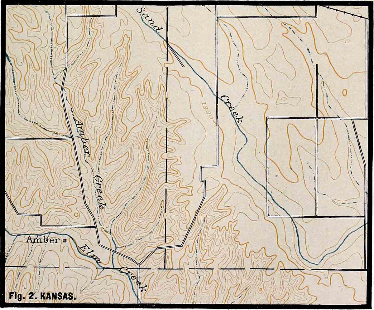
U. S. Geol. Surv.
Scale, 2+ mile per inch.
Fig.
2. KANSAS.
PLATE XIV.
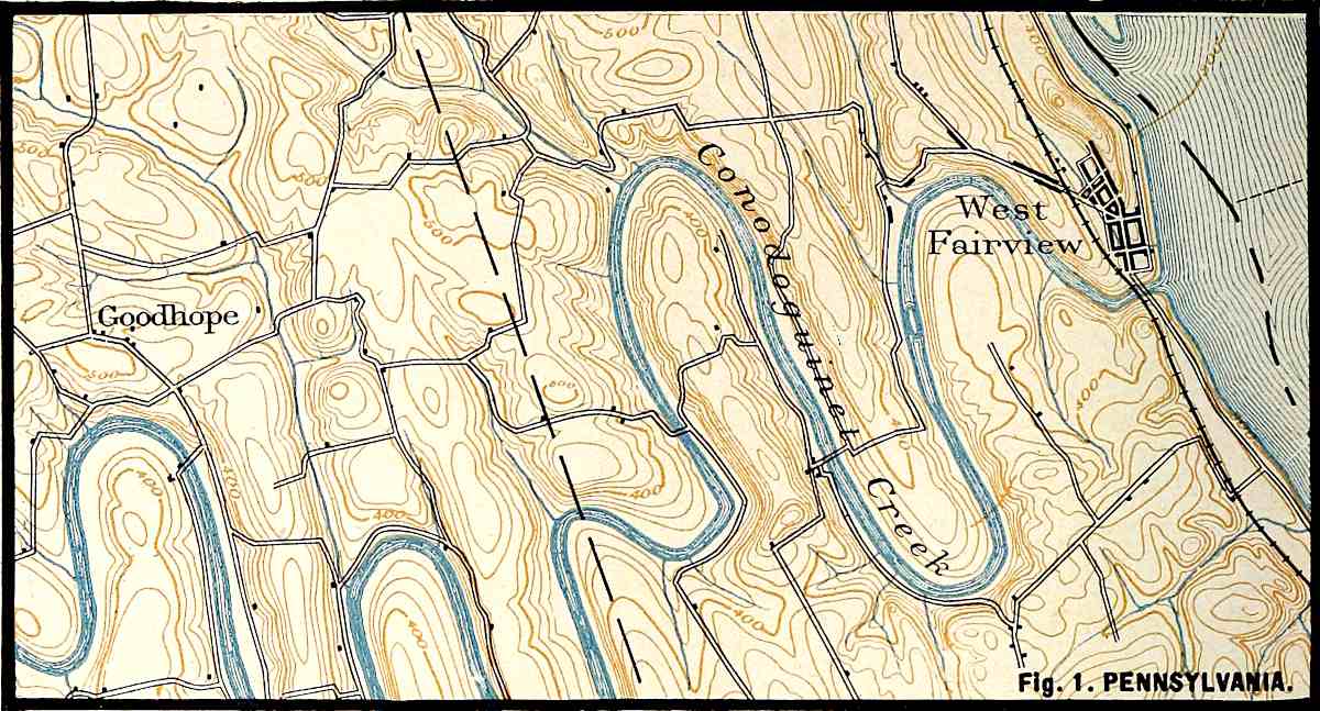
U. S. Geol. Surv.
Scale, 1+ mile per inch.
Fig.
1. PENNSYLVANIA.
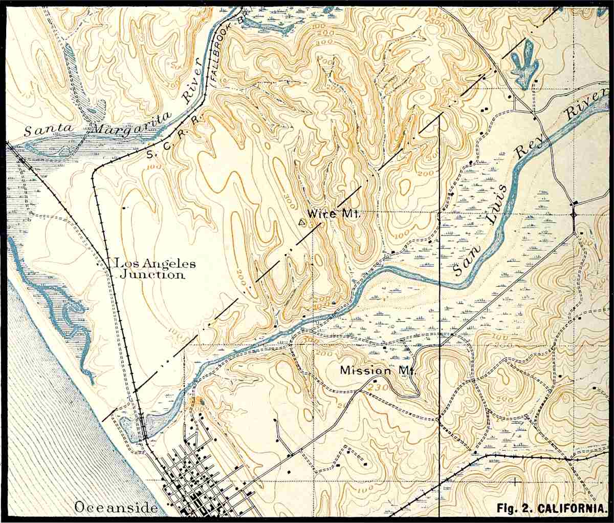
U. S. Geol. Surv.
Scale, 1+ mile per inch.
Fig.
2. CALIFORNIA.

Fig.
154.—Profile of a rejuvenated stream. The Lockatong River (
N. J.
) to the head of Mud Run.
Should the lower end of a tributary valley fail to be degraded as fast as the valley of the main at the point of junction, the tributary is out of topographic adjustment with its main. Falls or rapids may result. When the lower end of a tributary valley is distinctly above the level of its main, the former is called a hanging valley. Hanging valleys developed by stream erosion alone are not common except just after the recession of a falls past the mouth of a tributary. Hanging valleys, as well as the characters and relations illustrated by Figs. 152–154 are criteria of rejuvenation, but they must be applied with discretion. Such profiles, for example, as that shown in Fig. 154 may be developed when the rock of a stream’s bed is unequally resistant, and hanging valleys are generally a result of glaciation (see Chapter V).
Rejuvenated streams sometimes inherit certain peculiarities from their aged ancestors. Thus a rejuvenated stream may intrench the meanders possessed by the old stream which preceded (see Fig. 1, Pl. XIV, near Harrisburg, Pa.), and intrenched meanders are one of the marks of rejuvenated streams. They are not uncommon in the Appalachian Mountain regions, and are known in other parts of the world. The Seine and the Moselle furnish further illustrations.[59]