VOLUME VI SLICE VI Cockaigne to Columbus, Christopher (continued 9)
Reading edition
In 1904 the troubled term of President Marroquin came to an end, and by the narrowest of majorities General Rafael Reyes was elected in his place. He had been sent as a special envoy to Washington to protest against the recognition of Panama, and to attempt to revive the Hay-Herran treaty, and to secure favourable terms for Colombia in the matter of the canal. He failed to do so, but it was recognized that he had discharged his difficult task with great skill and ability. On his accession to office as president he found the country exhausted and disorganized, more especially in the department of finance, and the congress was on the whole hostile to him. Finding himself hampered in his efforts to reform abuses, the president dissolved the congress, and summoned a national constituent and legislative assembly to meet on the 15th of March 1905, and with its aid proceeded to modify the constitution.
Having personal acquaintance with the success of the rule of President Porfirio Diaz in Mexico, General Reyes determined to set about the regeneration of Colombia by similar methods. His tenure of the presidency was extended to a term of ten years from the 1st of January 1905, and the restriction as to re-election at the end of that term was withdrawn, other alterations being made in the constitution with the effect of placing General Reyes really in the position of a dictator. He soon proved that he had the ability and the integrity of purpose to use his great opportunity for the benefit of his country. His firm and masterful government and wise measures did much to allay the spirit of unrest which had so long been the bane of Colombia, and though an attempt at assassination was made in the spring of 1906, the era of revolution appeared to be over.
The chief foreign treaties entered into by Colombia in the last quarter of the 19th century were:—(1) A treaty with Great Britain, signed on the 27th of October 1888, for the extradition of criminals; (2) a treaty of friendship, commerce and navigation with Italy, signed on the 27th of October 1892; (3) two protocols with Italy, signed respectively on the 24th of May and on the 25th of August 1886, in connexion with the affair of the Italian subject Cerruti; (4) a consular convention with Holland, signed on the 20th of July 1881; (5) a treaty of peace and friendship with Spain, signed on the 30th of January 1881; (6) a convention with Spain for the reciprocal protection of intellectual property; (7) a concordat with the Vatican, signed on the 31st of December 1887; (8) an agreement with the Vatican, signed on the 20th of August 1892, in connexion with ecclesiastical jurisdiction; (9) an agreement with the republic of San Salvador, signed on the 24th of December 1880, in regard to the despatch of a delegate to an international congress; (10) a treaty of peace, friendship and commerce with Germany, signed on the 23rd of July 1892; (11) a treaty with the republic of Costa Rica, signed in 1880, for the delimitation of the boundary; (12) the postal convention, signed at Washington, on the 4th of July 1891; (13) a convention with Great Britain, signed on the 31st of July 1896, in connexion with the claim of Messrs Punchard, M‘Taggart, Lowther & Co.; (14) a treaty of friendship, commerce and navigation with Peru, signed on the 6th of August 1898; (15) an extradition treaty with Peru, signed on the 6th of August 1898; (16) a treaty of peace, friendship and defensive alliance with Venezuela, signed on the 21st of November 1896, and on the same date a treaty regulating the frontier commerce.
(G. E.)
Authorities.—C. E. Akers, A History of South America, 1854-1904 (New York, 1905); J. J. Borda, Compendio de historia de Colombia (Bogotá, 1890); Salvador Roldan Camacho, Notas de viaje (Bogotá, 1890), and Escritos varios (Bogotá, 1892); Dr Alfred Hettner, Reisen in den colombianischen Anden (Leipzig, 1888); Angel Lemos, Compendio de geografia de la Républica de Colombia (Medellin, 1894); Albert Millican, Travels and Adventures of an Orchid Hunter (London, 1891); J. M. Cordovez Mauro, Reminiscencias Santafé y Bogotá (Bogotá, 1899); Norris and Laird (Bureau of Navigation), Telegraphic Determination of Longitudes in Mexico, Central America, the West Indies, and on the North Coast of South America (Washington, 1891); R. Nuñez and H. Jalhay, La République de Colombia, géographie, histoire, &c. (Bruxelles, 1893); J. M. Q. Otero, Historia Patria (Bogotá, 1891); Lisimaco Palaü, La Républica de Colombia (1893); M. Paz and F. Perez, Atlas geográfico e histórico de la República de Colombia (1893); R. S. Pereira, Les États Unis de Colombia (Paris, 1883); Felipe Perez, Geografia general, fisica y politica de los Estados Unidos de Colombia (Bogotá, 1883); F. Loraine Petrie, The Republic of Colombia (London, 1906); Elisée Réclus, Geografia de Colombia (Bogotá, 1893); W. Reiss and A. Stübel, Reisen in Südamerika. Geologische Studien in der Republik Colombia (Berlin, 1893); Ernesto Restrepo, Ensayo etnografico y arqueologico de la provincia de los Quimbayas (Bogotá, 1892), and Estudios sobre los aborigines de Colombia (Bogotá, 1892); Vicente Restrepo, Estudio sobre las minas de oro y plata de Colombia (Bogotá, 1888, translated by C. W. Fisher, New York, 1886); W. L. Scruggs, The Colombian and Venezuelan Republics (London, 1899; Boston, 1900); W. Sievers, Reisen in der Sierra Nevada de Santa Marta (Leipzig, 1887); F. J. Vergara y Velasco, Nueva geografia de Colombia (Bogotá, 1892); Frank Vincent, Around and About South America (New York, 1890); R. G. Watson, Spanish and Portuguese South America during the Colonial Period (2 vols., London, 1884).
See also the diplomatic and consular reports of Great Britain and the United States; publications of the International Bureau of American Republics (Washington, D.C.); Bureau of Statistics, Commercial America in 1905 (Washington, 1906).
COLOMBIER, PIERRE BERTRAND DE (1299-1361), French cardinal and diplomatist, was born at Colombier in Ardèche. He was nephew and namesake of Cardinal Pierre Bertrand of Annonay. After a careful juristic education he was successively advocate at the parlement of Paris, intendant of the council of the count of Nevers (1321), and counsellor-clerk to the parlement (1329). Having taken holy orders, he became dean of St Quentin in 1330, and was employed to negotiate the marriage of the duke of Normandy, the future king John the Good of France, with the daughter of the king of Bohemia. In 1335 he became bishop of Nevers, in 1339 of Arras, and contributed to bring the county of Flanders into the kingdom of France. Created cardinal priest of St Susanna in 1344, he was employed by the pope on important missions, notably to negotiate peace or an armistice between France and England. Having become bishop of Ostia in 1353, he was sent next year to Charles IV. of Germany, and induced him to come to Italy to be crowned emperor at Rome, 1355. In 1356 he went to France to try to arrange a peace with England, and died in 1361 at the priory of Montaud near Avignon.
See A. Mazon, Essai historique sur l’état du Vivarais pendant la guerre de cent ans (Paris, 1889), with references there.
COLOMBO, the capital and principal seaport of Ceylon, situated on the west coast of the island. Pop. (1901) 154,691. Colombo stands to the south of the mouth of the river Kelani. The coast-land is here generally low-lying, but broken by slight eminences. The great artificial harbour, enclosed by breakwaters, is bounded on the south by a slight promontory. This is occupied by the quarter of the city known as the Fort, from the former existence of a fort founded by the Portuguese and reconstructed by the Dutch. In 1869 the governor, Sir Hercules Robinson (afterwards Lord Rosmead), obtained authority to demolish the fortifications, which were obsolete for purposes of defence, and required 6000 men to man them properly. The levelling of the walls and filling up of the moat made the Fort much more accessible and healthy, and since then it has become the business centre of the city. Here are situated Queen’s House, the governor’s residence; the secretariat or government offices, and other government buildings, such as the fine general post office and the customs house. Here also are most of the principal hotels, which have a peculiarly high reputation among European hotels in the East. A lofty tower serves as the principal lighthouse of the port and also as a clock-tower. On the south side of the Fort are extensive barracks. The old banqueting-hall of the Dutch governors is used as the garrison church of St Peter.
To the north-east of the Fort, skirting the harbour, are the Pettah, the principal native quarter, the districts of Kotahena and Mutwall, and suburbs beyond. In this direction the principal buildings are the Wolfendahl church, a massive Doric building of the Dutch (1749); the splendid Roman Catholic cathedral of St Lucia (completed in 1904); and St Thomas’s College (1851), which follows the lines of an English public school. Close to this last is the Anglican cathedral of Christ Church. The Kotahena temple is the chief Buddhist temple in Colombo.
To the north-east of the Fort is the Lake, a ramifying sheet of fresh water, which adds greatly to the beauty of the site of Colombo, its banks being clothed with luxuriant foliage and flowers. The narrow isthmus between this lake and the sea, south of the Fort, is called Galle Face, and is occupied chiefly by promenades and recreation grounds. The peninsula enclosed by two arms of the Lake is known as Slave Island, having been the site of a slave’s prison under the Dutch. South-east of this is the principal residential quarter of Colombo, with the circular Victoria Park as its centre. To the east of the park a series of parallel roads, named after former British governors, are lined with beautiful bungalows embowered in trees. This locality is generally known as the Cinnamon Gardens, as it was formerly a Dutch reserve for the cultivation of the cinnamon bush, many of which are still growing here. In the park is the fine Colombo Museum, founded by Sir William Gregory; and near the neighbouring Campbell Park are the handsome buildings of a number of institutions, such as Wesley College, and the General, Victoria Memorial Eye and other hospitals. South of Victoria Park is the Havelock racecourse. Among educational establishments not hitherto mentioned are the Royal College, the principal government institution, the government technical college and St Joseph’s Roman Catholic college. Most of the town is lighted by gas, and certain quarters with electric light, and electric tramways have been laid over several miles of the city roads. The water-supply is drawn from a hill region 30 m. distant.
Under British rule Colombo has shared in the prosperity brought to the island by the successive industries of coffee and tea-planting. At the height of the coffee-growing enterprise 20,000 men, women and children, chiefly Sinhalese and Tamils, found employment in the large factories and stores of the merchants scattered over the town, where the coffee was cleaned, prepared, sorted and packed for shipment. Tea, on the contrary, is prepared and packed on the estates; but there is a considerable amount of work still done in the Colombo stores in sorting, blending and repacking such teas as are sold at the local public sales; also in dealing with cacao, cardamoms, cinchona bark and the remnant still left of the coffee industry. But it is to its position as one of the great ports of call of the East that Colombo owes its great and increasing importance. A magnificent breakwater, 4200 ft. long, the first stone of which was laid by the prince of Wales in 1875, was completed in 1884. This breakwater changed an open roadstead into a harbour completely sheltered on the most exposed or south-west side; but there was still liability in certain months to storms from the north-west and south-east. Two additional arms were therefore constructed, consisting of a north-east and north-west breakwater, leaving two openings, one 800 ft. and the other 700 ft. wide, between the various sections. The area enclosed is 660 acres. A first-class graving-dock, of which the Admiralty bore half the cost, has also been added. These improvements caused Galle to be abandoned as a port of call for steamers in favour of Colombo, while Trincomalee has been abandoned as a naval station. The port has assumed first-class importance, mail steamers calling regularly as well as men-of-war and the mercantile marine of all nations; and it is now one of the finest artificial harbours in the world. The extension of railways also has concentrated the trade of the island upon the capital, and contributed to its rise in prosperity.
Colombo was originally known as the Kalantotta or Kalany ferry. By the Arabs the name was changed to Kolambu, and the town was mentioned by Ibn Batuta in 1346 as the largest and finest in Serendib. In 1517 the Portuguese effected a settlement, and in 1520 they fortified their port and bade defiance to the native besiegers. In 1586 the town was invested by Raja Singh, but without success. On its capture by the Dutch in 1656 it was a flourishing colony with convents of five religious orders, churches and public offices, inhabited by no fewer than 900 noble families and 1500 families dependent on mercantile or political occupations. In 1796 it was surrendered to the British.
COLON (formerly known as Aspinwall), a city of the Republic of Panama, on the Atlantic coast, in the Bay of Limon, and 47 m. by rail N.W. of the city of Panama. Pop. (1908) about 3000, consisting largely of Jamaica negroes and natives of mixed Spanish, Indian and African descent. It is served by the Panama railway, which crosses the Isthmus of Panama from ocean to ocean. Colon has a deep, though poorly sheltered harbour, and is either the terminus or a place of call for seven lines of steamships. It thus serves as an entrepôt for much of the commerce between Atlantic and Pacific ports, and between the interior towns of Central and South America and the cities of Europe and the United States. The city lies on the west side of the low island of Manzanillo, is bordered on the landward sides by swamp, and consists mainly of unimposing frame houses and small shops. The most attractive parts are the American quarter, where the employés of the Panama railway have their homes, and the old French quarter, where dwelt the French officers during their efforts to build the canal. In this last district, near the mouth of the old canal, stands a fine statue of Christopher Columbus, the gift of the empress Eugénie in 1870. Here also stands the mansion erected and occupied by Ferdinand de Lesseps during his residence on the isthmus. With the exception of railway shops, there are no important industrial establishments.
Colon dates its origin from the year 1850, when the island of Manzanillo was selected as the Atlantic terminus of the Panama railway. The settlement was at first called Aspinwall, in honour of William H. Aspinwall (1807-1875), one of the builders of the railway; but some years afterwards its name was changed by legislative enactment to Colon, in honour of Christopher Columbus, who entered Limon Bay in 1502. The original name, however, survived among the English-speaking inhabitants for many years after this change. With the completion of the railway in 1855, the town supplanted Chagres (q.v.) as the principal Atlantic port of the isthmus. Later it acquired increased importance through its selection by de Lesseps as the site for the Atlantic entrance to his canal. During the revolution of 1885 it was partly burned and was rebuilt on a somewhat larger plan. As the city has always been notoriously unhealthful, the United States, on undertaking the construction of the Panama Canal (q.v.), became interested in preventing its becoming a centre of infection for the Canal Zone, and by the treaty of November 1903 secured complete jurisdiction in the city and harbour over all matters relating to sanitation and quarantine, and engaged to construct a system of waterworks and sewers in the municipality, which had been practically completed in 1907. The United States government has also opened a port at Cristobal, within the Canal Zone.
COLON, a town of Matanzas province, Cuba, on the railway between Matanzas and Santa Clara, and the centre of a rich sugar-planting country. Pop. (1907) 7124.
COLON, (1) (Gr. κόλον, miswritten and mispronounced as κῶλον, the term being taken from κόλος, curtailed), in anatomy, that part of the greater intestine which extends from the caecum to the rectum (see Alimentary Canal). (2.) (Gr. κῶλον, a member or part), originally in Greek rhetoric a short clause longer than the “comma,” hence a mark (:), in punctuation, used to show a break in construction greater than that marked by the semicolon (;), and less than that marked by the period or full stop. The sign is also used in psalters and the like to mark off periods for chanting. The word is applied in palaeography to a unit of measure in MSS., amounting in length to a hexameter line.
COLONEL (derived either from Lat. columna, Fr. colonne, column, or Lat. corona, a crown), the superior officer of a regiment of infantry or cavalry; also an officer of corresponding rank in the general army list. The colonelcy of a regiment formerly implied a proprietary right in it. Whether the colonel commanded it directly in the field or not, he always superintended its finance and interior economy, and the emoluments of the office, in the 18th century, were often the only form of pay drawn by general officers. The general officers of the 17th and 18th centuries were invariably colonels of regiments, and in this case the active command was exercised by the lieutenant-colonels. At the present day, British general officers are often, though not always, given the colonelcy of a regiment, which has become almost purely an honorary office. The sovereign, foreign sovereigns, royal princes and others, hold honorary colonelcies, as colonels-in-chief or honorary colonels of many regiments. In other armies, the regiment being a fighting unit, the colonel is its active commander; in Great Britain the lieutenant-colonel commands in the field the battalion of infantry and the regiment of cavalry. Colonels are actively employed in the army at large in staff appointments, brigade commands, &c. extra-regimentally. Colonel-general, a rank formerly used in many armies, still survives in the German service, a colonel-general (General-Oberst) ranking between a general of infantry, cavalry or artillery, and a general field marshal (General-Feldmarschall). Colonels-general are usually given the honorary rank of general field marshal.
COLONIAL OFFICE, the department of the administration of the United Kingdom which deals with questions affecting the various colonial possessions of the British crown. The department as it now exists is of comparatively modern creation, dating only from 1854. The affairs of the English colonies began to assume importance at the Restoration, and were at first entrusted to a committee of the privy council, but afterwards transferred to a commission created by letters patent. From 1672 to 1675 the council for trade was combined with this commission, but in the latter year the colonies were again placed under the control of the privy council. This arrangement continued until 1695, when a Board of Trade and Plantations was created; its duty, however, was confined to collecting information and giving advice when required. The actual executive work was performed by the secretary of state for the southern department, who was assisted, from 1768 to 1782, by a secretary of state for the colonies. Both the Board of Trade and Plantations and the additional secretary were abolished in 1782, and the executive business wholly given over to the home office. In 1794 a third secretary of state was reappointed, and in 1801 this secretary was designated as secretary of state for war and the colonies. In 1854 the two offices were separated, and a distinct office of secretary of state for the colonies created.
The secretary of state for the colonies is the official medium of communication with colonial governments; he has certain administrative duties respecting crown colonies, and has a right of advising the veto of an act of a colonial legislature—this veto, however, is never exercised in the case of purely local statutes. He is assisted by a permanent and a parliamentary under-secretary and a considerable clerical staff.
As reorganized in 1907 the colonial office consists of three chief departments: (1) the Dominions Department, dealing with the affairs of the self-governing over-sea dominions of the British crown, and of certain other possessions geographically connected with those dominions; (2) the Colonial Department, dealing with the affairs of crown colonies and protectorates; (3) the General Department, dealing with legal, financial and other general business. In addition to these three departments, standing committees exist to take a collective view of such matters as contracts, concessions, mineral and other leases, and patronage.
COLONNA, a noble Roman family, second only to the Gaetani di Sermoneta in antiquity, and first of all the Roman houses in importance. The popes Marcellinus, Sixtus III., Stephen IV. and Adrian III. are said to have been members of it, but the authentic pedigree of the family begins with Pietro, lord of Columna, Palestrina and Paliano (about 1100), probably a brother of Pope Benedict IX. His great grandson Giovanni had two sons, respectively the founders of the Colonna di Paliano and Colonna di Sciarra lines. The third, or Colonna-Romano line, is descended from Federigo Colonna (1223). In the 12th century we find the Colonna as counts of Tusculum, and the family was then famous as one of the most powerful and turbulent of the great Roman clans; its feuds with the Orsini and the Gaetani are a characteristic feature of medieval Rome and the Campagna; like the other great nobles of the Campagna the Colonna plundered travellers and cities, and did not even spare the pope himself if they felt themselves injured by him. Boniface VIII. attempted to break their power, excommunicated them in 1297, and confiscated their estates. He proclaimed a crusade against them and captured Palestrina, but they afterwards revenged themselves by besieging him at Anagni, and Sciarra Colonna laid violent hands on His Holiness, being with difficulty restrained from actually murdering him (1303). In 1347 the Colonna, at that time almost an independent power, were defeated by Cola di Rienzi, but soon recovered. Pope Martin V. (1417-1431) was a Colonna, and conferred immense estates on his family, including Marino, Frascati, Rocca di Papa, Nettuno, Palinao, &c., in the Campagna, and other fiefs in Romagna and Umbria. Their goods were frequently confiscated and frequently given back, and the house was subject to many changes of fortune; during the reign of Pope Alexander VI. they were again humbled, but they always remained powerful and important, and members of the family rose to eminence as generals, prelates and statesmen in the service of the Church or other powers. In the war of 1522 between France and Spain there were Colonna on both sides, and at the battle of Lepanto (1571) Marc Antonio Colonna, who commanded the papal contingent, greatly distinguished himself. A detailed record of the Colonna family would be a history of Rome. To-day there are three lines of Colonna: (1) Colonna di Paliano, with two branches, the princes and dukes of Paliano, and the princes of Stigliano; (2) Colonna di Sciarra, with two branches, Colonna di Sciarra, princes of Carbagnano, and Barberini-Colonna, princes of Palestrina; and (3) Colonna-Romano. The Colonna palace, one of the finest in Rome, was begun by Martin V. and contains a valuable picture and sculpture gallery.
See A. von Reumont, Geschichte der Stadt Rom (Berlin, 1868), containing an elaborate account of the family; F. Gregorovius, Geschichte der Stadt Rom (Stuttgart, 1872); Almanack de Gotha. (L. V.*)
COLONNA, GIOVANNI PAOLO (circa 1637-1695), Italian musician, was born in Bologna about 1637 and died in the same city on the 28th of November 1695. He was a pupil of Filippuzzi in Bologna, and of Abbatini and Benevoli in Rome, where for a time he held the post of organist at S. Apollinare. A dated poem in praise of his music shows that he began to distinguish himself as a composer in 1659. In that year he was chosen organist at S. Petronio in Bologna, where on the 1st of November 1674 he was made chapel-master. He also became president of the Philharmonic Academy of Bologna. Most of Colonna’s works are for the church, including settings of the psalms for three, four, five and eight voices, and several masses and motets. He also composed an opera, under the title Amilcare, and an oratorio, La Profezia d’ Eliseo. The emperor Leopold I. received a copy of every composition of Colonna, so that the imperial library in Vienna possesses upwards of 83 church compositions by him. Colonna’s style is for the most part dignified, but is not free from the inequalities of style and taste almost unavoidable at a period when church music was in a state of transition, and had hardly learnt to combine the gravity of the old style with the brilliance of the new.
COLONNA, VITTORIA (1490-1547), marchioness of Pescara, Italian poet, daughter of Fabrizio Colonna, grand constable of the kingdom of Naples, and of Anna da Montefeltro, was born at Marino, a fief of the Colonna family. Betrothed when four years old at the instance of Ferdinand, king of Naples, to Ferrante de Avalos, son of the marquis of Pescara, she received the highest education and gave early proof of a love of letters. Her hand was sought by many suitors, including the dukes of Savoy and Braganza, but at nineteen, by her own ardent desire, she was married to de Avalos on the island of Ischia. There the couple resided until 1511, when her husband offered his sword to the League against the French. He was taken prisoner at the battle of Ravenna (1512) and conveyed to France. During the months of detention and the long years of campaigning which followed, Vittoria and Ferrante corresponded in the most passionate terms both in prose and verse. They saw each other but seldom, for Ferrante was one of the most active and brilliant captains of Charles V.; but Vittoria’s influence was sufficient to keep him from joining the projected league against the emperor after the battle of Pavia (1525), and to make him refuse the crown of Naples offered to him as the price of his treason. In the month of November of the same year he died of his wounds at Milan. Vittoria, who was hastening to tend him, received the news of his death at Viterbo; she halted and turned off to Rome, and after a brief stay departed for Ischia, where she remained for several years. She refused several suitors, and began to produce those Rime spirituali which form so distinct a feature in her works. In 1529 she returned to Rome, and spent the next few years between that city, Orvieto, Ischia and other places. In 1537 we find her at Ferrara, where she made many friends and helped to establish a Capuchin monastery at the instance of the reforming monk Bernardino Ochino, who afterwards became a Protestant. In 1539 she was back in Rome, where, besides winning the esteem of Cardinals Reginald Pole and Contarini, she became the object of a passionate friendship on the part of Michelangelo, then in his sixty-fourth year. The great artist addressed some of his finest sonnets to her, made drawings for her, and spent long hours in her society. Her removal to Orvieto and Viterbo in 1541, on the occasion of her brother Ascanio Colonna’s revolt against Paul III., produced no change in their relations, and they continued to visit and correspond as before. She returned to Rome in 1544, staying as usual at the convent of San Silvestro, and died there on the 25th of February 1547.
Cardinal Bembo, Luigi Alamanni and Baldassare Castiglione were among her literary friends. She was also on intimate terms with many of the Italian Protestants, such as Pietro Carnesecchi, Juan de Valdes and Ochino, but she died before the church crisis in Italy became acute, and, although she was an advocate of religious reform, there is no reason to believe that she herself became a Protestant. Her life was a beautiful one, and goes far to counteract the impression of the universal corruption of the Italian Renaissance conveyed by such careers as those of the Borgia. Her amatory and elegiac poems, which are the fruits of a sympathetic and dainty imitative gift rather than of any strong original talent, were printed at Parma in 1538; a third edition, containing sixteen of her Rime Spirituali, in which religious themes are treated in Italian, was published at Florence soon afterwards; and a fourth, including a still larger proportion of the pious element, was issued at Venice in 1544.
A great deal has been written about Vittoria Colonna, but perhaps the best account of her life is A. Luzio’s Vittoria Colonna (Modena, 1885); A. von Reumont’s Vita di Vittoria Colonna (Italian corrected edit., Turin, 1883) is also excellent; F. le Fèvre’s Vittoria Colonna (Paris, 1856) is somewhat inaccurate, but T. Roscoe’s Vittoria Colonna (London, 1868) may be recommended to English readers; P. E. Visconti’s Le Rime di Vittoria Colonna (Rome, 1846) deals with her poems.
(L. V.*)
COLONNADE, in architecture, a range of columns (Ital. colonna) in a row. When extended so as to enclose a temple, it is called a peristyle, and the same term applies when round an open court, as in the houses at Pompeii. When projecting in front of a building, it is called a portico, as in the Pantheon at Rome and the National Gallery in London. When enclosed between wings, as in Perrault’s façade to the Louvre, it is correctly described as a colonnade. Colonnades lined the streets of the towns in Syria and Asia Minor, and they were largely employed in Rome.
COLONSAY, an island of the Inner Hebrides, Argyllshire, Scotland, 10 m. S. of the Ross of Mull. It is 7½ m. long by 3 m. broad. The highest point is Carnan Eoin (470 ft.). Towards the middle of the island lies Loch Fada, nearly 2 m. long but very narrow, and there are two other small lakes and a few streams. The coast-line, with frequent beautiful sandy reaches, is much indented, the chief bays being Kiloran, Kilchattan and Staosunaig. On the north-western coast the cliffs are particularly fine. To the south, separated by a strait that is fordable at low water, lies the isle of Oronsay, 2¼ m. long by 2¾ m. wide. Both islands contain a number of ecclesiastical remains, standing stones, and some beautiful sculptured crosses. They are named after Columba and Oran, who are said to have stopped here after they left Ireland. There is regular communication between Scalasaig and Glasgow and the Clyde ports. The golf-course at Kilchattan lends a touch of modernity to these remote islands. Near Scalasaig a granite obelisk has been erected to the memory of Sir Duncan M‘Neill (1794-1874), a distinguished Scottish lawyer, who took the title of Lord Colonsay when he became a lord of appeal. The soil of both islands is fertile, potatoes and barley being raised and cattle pastured. Population: Colonsay (1901), 301; Oronsay (1901), 12.
COLONY (Lat. colonia, from colonus, a cultivator), a term most commonly used to denote a settlement of the subjects of a sovereign state in lands beyond its boundaries, owning no allegiance to any foreign power, and retaining a greater or less degree of dependence on the mother country. The founding and the growth of such communities furnish matter for an interesting chapter in the history as well of ancient as of modern civilization; and the regulation of the relations between the parent state and its dependencies abroad gives rise to important problems alike in national policy and in international economics.
It was mainly the spirit of commercial enterprise that led the Phoenicians to plant their colonies upon the islands and along the southern coast of the Mediterranean; and even beyond the Pillars of Hercules this earliest great colonizing race left enduring traces of its maritime supremacy. Carthage, indeed, chief of the Phoenician settlements, sent forth colonies to defend her conquests and strengthen her military power; and these sub-colonies naturally remained in strict subjection to her power, whereas the other young Phoenician states assumed and asserted entire independence.
In this latter respect the Greek colonies resembled those of the Phoenicians. From a very early period the little civic communities of Greece had sent forth numerous colonizing streams. At points so far asunder as the Tauric Chersonese, Cyrene and Massilia were found prosperous centres of Greek commercial energy; but the regions most thickly peopled by settlers of Greek descent were the western seaboard of Asia Minor, Sicily and the southern parts of the Italian peninsula. Nor were the least prosperous communities those which were sprung from earlier colonies. The causes that led to the foundation of the Greek colonies were very various. As in Phoenicia, pressure created by the narrow limits of the home country coincided with an adventurous desire to seek new sources of wealth beyond seas; but very many Greek emigrations were caused by the expulsion of the inhabitants of conquered cities, or by the intolerable domination of a hated but triumphant faction within the native state. The polity of the new community, often founded in defiance of the home authorities, might either be a copy of that just left behind or be its direct political antithesis. But wherever they went, and whether, as apparently in Asia Minor, Greek blood was kept free from barbaric mixture, or whether, as in Magna Graecia and Sicily, it was mingled with that of the aboriginal races, the Greek emigrants carried with them the Hellenic spirit and the Hellenic tongue; and the colonies fostered, not infrequently more rapidly and more brilliantly than at home, Greek literature, Greek art and Greek speculation. The relation to be preserved towards the mother states was seldom or never definitely arranged. But filial feeling and established custom secured a measure of kindly sympathy, shown by precedence yielded at public games, and by the almost invariable abstinence of the colony from a hostile share in wars in which the mother city was engaged.
The relation of Rome to her colonies was altogether different. No Roman colony started without the sanction and direction of the public authority; and while the Colonia Romano differed from the Colonia Latina in that the former permitted its members to retain their political rights intact, the colony, whether planted within the bounds of Italy or in provinces such as Gaul or Britain, remained an integral part of the Roman state. In the earlier colonies, the state allotted to proposing emigrants from amongst the needy or discontented class of citizens portions of such lands as, on the subjection of a hostile people, the state took into its possession as public property. At a later time, especially after the days of Sulla, the distribution of the territories of a vanquished Roman party was employed by the victorious generals as an easy means of satisfying the claims of the soldiery by whose help they had triumphed. The Roman colonies were thus not merely valuable as propugnacula of the state, as permanent supports to Roman garrisons and armies, but they proved a most effective means of extending over wide bounds the language and the laws of Rome, and of inoculating the inhabitants of the provinces with more than the rudiments of Roman civilization.
The occupation of the fairest provinces of the Roman empire by the northern barbarians had little in common with colonization. The Germanic invaders came from no settled state; they maintained loosely, and but for a short while, any form of brotherhood with the allied tribes. A nearer parallel to Greek colonization may be found in Iceland, whither the adherents of the old Norse polity fled from the usurpation of Harold Haarfager; and the early history of the English pale in Ireland shows, though not in orderliness and prosperity, several points of resemblance to the Roman colonial system.
Though both Genoese and Venetians in their day of power planted numerous trading posts on various portions of the Mediterranean shores, of which some almost deserve the name of colonies, the history of modern colonization on a great scale opens with the Spanish conquests in America. The first Spanish adventurers came, not to colonize, but to satisfy as rapidly as possible and by the labour of the enslaved aborigines, their thirst for silver and gold. Their conquests were rapid, but the extension of their permanent settlements was gradual and slow. The terrible cruelty at first exercised on the natives was restrained, not merely by the zeal of the missionaries, but by effective official measures; and ultimately home-born Spaniards and Creoles lived on terms of comparative fairness with the Indians and with the half-breed population. Till the general and successful revolt of her American colonies, Spain maintained and employed the latter directly and solely for what she conceived to be her own advantage. Her commercial policy was one of most irrational and intolerable restriction and repression; and till the end of Spanish rule on the American continent, the whole political power was retained by the court at Madrid, and administered in the colonies by an oligarchy of home-bred Spaniards.
The Portuguese colonization in America, in most respects resembling that of Spain, is remarkable for the development there given to an institution sadly prominent in the history of the European colonies. The nearness of Brazil to the coast of Africa made it easy for the Portuguese to supply the growing lack of native labour by the wholesale importation of purchased or kidnapped Africans.
Of the French it is admitted that in their colonial possessions they displayed an unusual faculty for conciliating the prejudices of native races, and even for assimilating themselves to the latter. But neither this nor the genius of successive governors and commanders succeeded in preserving for France her once extensive colonies in Canada or her great influence in India. In Algeria and West Africa the French government has not merely found practical training schools for her own soldiers, but by opening a recruiting field amongst the native tribes it has added an available contingent to the French army.
The Dutch took early a leading share in the carrying trade of the various European colonies. They have still extensive colonies in the East Indian Archipelago, as well as possessions in the West Indies. The Danish dependencies in the Antilles are but trifling in extent or importance.
It is the English-speaking race, however, that has shown the most remarkable energy and capacity for colonization. The English settlements in Virginia, New England, New York, New Jersey, Maryland, Pennsylvania, Delaware, South Carolina, North Carolina, and Georgia had, between the first decade of the 17th and the seventh decade of the 18th century, developed into a new nation, the United States of America. It is unnecessary here to deal with the development of what have since been the two great independent branches of the English-speaking people—those of the United States (q.v.) and of the British Empire (q.v.), as their history is given elsewhere. But the colonizing genius which, with the British Isles as centre, has taken up the “white man’s burden” in all quarters of the globe, is universally recognized. In the problems of government raised by the organization of the British dominions beyond the seas the system of colonization has been developed to an extent unknown under any other national flag.
COLOPHON, an ancient city of Ionia, situated inland about 15 m. N. of Ephesus. Its port was at Notium or New Colophon. The site, now called Tracha (only recognized towards the end of the 19th century), lies near Diermendere, 5 m. S. of Develikeui station on the Smyrna-Aidin railway, and about 2 m. from the farms and hamlet of Malkajik. It is almost entirely under cultivation, and there is little to be seen but remains of the walls and certain tumuli. Rich tombs, however, have been found beside the old roads leading to it, and the site is usually regarded as a particularly promising one for excavation, since Colophon was a very flourishing city in the great period of Ionia and had declined and been largely superseded by Notium before the Roman age. The common belief, however, that it had no existence after the time of Lysimachus is not borne out by the remains on the site. Founded by Andracmon of Pylos, it was at the acme of its prosperity in the 8th and 7th centuries B.C. up to the epoch of its sack by Gyges of Lydia in 665. It claimed to have produced Homer, but its greatest genuine literary name was Mimnermus. It seems to have been ruled by a rich aristocracy which provided a famous troop of horse; and, from the Greek saying, usually supposed to refer to the decisive effect of the final charge of this troop in battle, the word colophon has come to be used for the final note appended to old printed books, containing date, &c. In 287 Lysimachus transferred a part of the population to his new city at Ephesus. Though an Ionian colony Colophon did not share in the common festival of the Apaturia and seems to have been isolated for some reason among its neighbours, with one of whom, Ephesus, it was constantly at enmity. The forts by which Ephesus protected itself against Colophonian invasion are still to be seen on the hills north of the Caystrus.
Notium or New Colophon contained the important shrine of the Clarian Apollo, whose site has recently been identified with probability by Th. Makridy Bey during excavations conducted for the Ottoman museum.
See C. Schuchardt in Athen. Mitteil. (1886); W. M. Ramsay, Hist. Geog. of Asia Minor (addenda) (1890).
(D. G. H.)
COLOPHON, a final paragraph in some manuscripts and many early printed books (see Book), giving particulars as to authorship, date and place of production, &c. Before the invention of printing, a scribe when he had finished copying a book occasionally added a final paragraph at the end of the text in which he recorded the fact, and (if he were so minded) expressed his thankfulness to God, or asked for the prayers of readers. In the famous Bodleian MS. 264 of the Roman d’Alexandre there is an unusually full note of this kind recording the completion of the copy on the 18th of December 1338 and ending—
“Explicit iste liber, scriptor sit crimine liber, Christus scriptorem custodiat ac det honorem.”
Both in manuscripts and also in early printed books authors made use of such a final paragraph for expressing similar feelings. Thus the Guillermus who made a famous collection of sermons on the gospels for Sundays and saints’ days records its completion in 1437 and submits it to the correction of charitable readers, and Sir Thomas Malory notes that his Morte d’Arthur “was ended the ix yere of the reygne of Kyng Edward the fourth,” and bids his readers “praye for me whyle I am on lyue that God sende me good delyuerance, and whan I am deed I praye you all praye for my soule.” So again Jacobus Bergomensis records that his Supplementum Chronicarum was finished “anno salutis nostre 1483. 3º Kalendas Julii in ciuitate Bergomi: mihi vero a natiuitate quadragesimo nono,” and in the subsequent editions which he revised brings both the year and his own age up to date. Before printing was invented, however, such paragraphs were exceptional, and many of the early printers, notably Gutenberg himself, were content to allow their books to go out without any mention of their own names. Fust and Schoeffer, on the other hand, printed at the end of their famous psalter of 1457 the following paragraph in red ink:—Presens spalmorum (sic for psalmorum) codex venustate capitalium decoratus Rubricationibusque sufficienter distinctus, Adinuentione artificiosa imprimendi ac caracterizandi absque calami vlla exaracione sic effigiatus, Et ad eusebiam dei industrie est consummatus, Per Iohannem fust ciuem maguntinum, Et Petrum Schoffer de Gernszheim Anno domini Millesimo. cccc. lvii In vigilia Assumpcionis. Similar paragraphs in praise of printing and of Mainz as the city where the art was brought to perfection appear in most of the books issued by the partners and after Fust’s death by Schoeffer alone, and were widely imitated by other printers. In their Latin Bible of 1462 Fust and Schoeffer added a device of two shields at the end of the paragraph, and this addition was also widely copied. Many of these final paragraphs give information of great value for the history of printing; many also, especially those to the early editions of the classics printed in Italy, are written in verse. As the practice grew up of devoting a separate leaf or page to the title of a book at its beginning, the importance of these final paragraphs slowly diminished, and the information they gave was gradually transferred to the title-page. Complete title-pages bearing the date and name of the publishers are found in most books printed after 1520, and the final paragraph, if retained at all, was gradually reduced to a bare statement of the name of the printer. From the use of the word in the sense of a “finishing stroke,” such a final paragraph as has been described is called by bibliographers a “colophon” (Gr. κολοφών), but at what period this name for it was first used has not been ascertained. It is quite possibly not earlier than the 18th century. (For origin see Colophon [city].)
(A. W. Po.)
COLORADO, a state of the American union, situated between 41° and 37° N. lat. and 102° and 109° W. long., bounded N. by Wyoming and Nebraska, E. by Nebraska and Kansas, S. by Oklahoma and New Mexico, and W. by Utah. Its area is 103,948 sq. m. (of which 290 are water surface). It is the seventh largest state of the Union.
Physiography.—Colorado embraces in its area a great variety of plains, mountains and plateaus. It lies at the junction of the Great Plains—which in their upward slant to the westward attain an average elevation of about 4000 ft. along the east boundary of the state—with the Rocky Mountains, to the west of which is a portion of the Colorado Plateau. These are the three physiographic provinces of the state (see also United States, section Geology, ad fin., for details of structure). The last-named includes a number of lofty plateaus—the Roan or Book, Uncompahgre, &c., which form the eastern continuation of the high plateaus of Utah—and covers the western quarter of the state. Its eastern third consists of rich, unbroken plains. On their west edge lies an abrupt, massive, and strangely uniform chain of mountains, known in the neighbourhood of Colorado Springs as the Rampart Range, and in the extreme north as the Front Range, and often denominated as a whole by the latter name. The upturning of the rocks of the Great Plains at the foot of the Front Range develops an interesting type of topography, the harder layers weathering into grotesquely curious forms, as seen in the famous Garden of the Gods at the foot of Pike’s Peak. Behind this barrier the whole country is elevated 2000 ft. or so above the level of the plains region. In its lowest portions just behind the front ranges are the natural “parks”—great plateaus basined by superb enclosing ranges; and to the west of these, and between them, and covering the remainder of the state east of the plateau region, is an entanglement of mountains, tier above tier, running from north to south, buttressed laterally with splendid spurs, dominated by scores of magnificent peaks, cut by river valleys, and divided by mesas and plateaus. These various chains are known by a multitude of local names. Among the finest of the chains are the Rampart, Sangre de Cristo, San Juan, Sawatch (Saguache) and Elk ranges. The first, like the other ranges abutting from north to south upon the region of the prairie, rises abruptly from the plain and has a fine, bold outline. It contains a number of fine summits dominated by Pike’s Peak (14,108 ft.). Much more beautiful as a whole is the Sangre de Cristo range. At its southern end are Blanca Peak (14,390) and Old Baldy (14,176, Hayden), both in Costilla county; to the northward are Rito Alto Peak (12,989, Wheeler), in Custer county, and many others of almost equal height and equal beauty. The mountains of the south-west are particularly abrupt and jagged. Sultan Mountain (13,366, Hayden), in San Juan county, and Mt. Eolus (14,079), in La Plata county, dominate the fine masses of the San Juan ranges; and Mt. Sneffels (14,158, Hayden), Ouray county, and Uncompahgre Peak (14,289), Hinsdale county, the San Miguel and Uncompahgre ranges, which are actually parts of the San Juan. Most magnificent of all the mountains of Colorado, however, are the Sawatch and adjoining ranges in the centre of the state. The former (the name is used a little loosely) consists of almost a solid mass of granite, has an average elevation of probably 13,000 ft., presents a broad and massive outline, and has a mean breadth of 15 to 20 m. Mt. Ouray (13,956 ft.), in Chaffee county, may be taken as the southern end, and in Eagle county, the splendid Mount of the Holy Cross (14,170)—so named from the figure of its snow-filled ravines—as the northern. Between them lie: in Chaffee county, Mt. Shavano (14,239, Hayden), Mt. Princeton (14,196, Hayden), Mt. Yale (14,187, Hayden), Mt. Harvard (14,375, Hayden), and La Plata Peak (14,342); in Pitkin county, Grizzly Peak (13,956, Hayden); in Lake county, Elbert Peak (14,421), and Massive mountain (14,424), the highest peak in the state; on the boundary between Summit and Park counties, Mt. Lincoln (14,297, Hayden); and, in Summit county, Mt. Fletcher (14,265). The Elk range is geologically interesting for the almost unexampled displacement of the strata of which it is composed, and the apparent confusion which has thence arisen. Among the most remarkable of its separate summits, which rise superbly in a crescent about Aspen, are North Italian Peak (13,225), displaying the red, white and green of Italy’s national colours, White Rock Mountain (13,532), Mt. Owen (13,102), Teocalli Mountain (13,220), Snow Mass (13,970, Hayden) and Maroon (14,003, Hayden) mountains, Castle Peak (14,259), Capitol Mountain (13,997, Hayden), Pyramid Peak (13,885, Hayden), Taylor Peak (13,419), and about a dozen other summits above 12,000 ft. A few miles to the north and north-east of the Mount of the Holy Cross are Red Mountain (13,333, Wheeler), in Eagle county, Torrey Peak (14,336, Hayden) and Gray’s Peak (14,341, Hayden), in Summit county, Mt. Evans (14,330, Hayden), in Clear Creek county, and Rosalie Peak (13,575), in Park county; a little farther north, in Gilpin, Grand and Clear Creek counties, James Peak (13,283, Hayden), and, in Boulder county, Long’s Peak (14,271, Hayden). Many fine mountains are scattered in the lesser ranges of the state. Altogether there are at least 180 summits exceeding 12,000 ft. in altitude, more than 110 above 13,000 and about 40 above 14,000.
Cirques, valley troughs, numberless beautiful cascades, sharpened alpine peaks and ridges, glacial lakes, and valley moraines offer everywhere abundant evidence of glacial action, which has modified profoundly practically all the ranges. The Park Range east of Leadville, and the Sawatch Range, are particularly fine examples. Much of the grandest scenery is due to glaciation.
One of the most remarkable orographical features of the state are the great mountain “parks”—North, Estes, Middle, South and San Luis—extending from the northern to the southern border of the state, and lying (with the exception of Middle Park) just east of the continental divide. These “parks” are great plateaus, not all of them level, lying below the barriers of surrounding mountain chains. North Park, the highest of all, is a lovely country of meadow and forest. Middle Park is not level, but is traversed thickly by low ranges like the Alleghanies; in the bordering mountain rim are several of the grandest mountain peaks and some of the most magnificent scenery of the state. Estes Park is small, only 20 m. long and never more than 2 m. broad; it is in fact the valley of Thompson Creek. Its surface is one of charming slopes, and by many it is accounted among the loveliest of Colorado valleys. Seven ranges lie between it and the plains. South Park is similarly quiet and charming in character. Much greater than any of these is San Luis Park. The surface is nearly as flat as a lake, and it was probably at one time the bed of an inland sea. In the centre there is a long narrow lake fed by many streams. It has no visible outlet, but is fresh. The San Luis Park, which runs into New Mexico, is traversed by the Rio Grande del Norte and more than a dozen of its mountain tributaries. These parks are frequented by great quantities of large game, and—especially the North and Middle—are famous hunting-grounds. They are fertile, too, and as their combined area is something like 13,000 sq. m. they are certain to be of great importance in Colorado’s agricultural development.
The drainage system of the state is naturally very complicated. Eleven topographical and climatic divisions are recognized by the United States Weather Bureau within its borders, including the several parks, the continental divide, and various river valleys. Of the rivers, the North Platte has its sources in North Park, the Colorado (the Gunnison and Grand branches) in Middle Park, the Arkansas and South Platte in South Park—where their waters drain in opposite directions from Palmer’s Lake—the Rio Grande in San Luis Park. Three of these flow east and south-east to the Missouri, Mississippi and the Gulf; but the waters of the Colorado system flow to the south-west into the Gulf of California. Among the other streams, almost countless in number among the mountains, the systems of the Dolores, White and Yampa, all in the west, are of primary importance. The scenery on the head-waters of the White and Bear, the upper tributaries of the Gunnison, and on many of the minor rivers of the south-west is wonderfully beautiful. The South Platte falls 4830 ft. in the 139 m. above Denver; the Grand 3600 ft. in the 224 m. between the mouth of the Gunnison and the Forks; the Gunnison 6477 ft. in 200 m. to its mouth (and save for 16 m. never with a gradient of less than 10 ft.); the Arkansas 7000 ft. in its 338 m. west of the Kansas line. Of the smaller streams the Uncompahgre falls 2700 ft. in 134 m., the Las Animas 7190 ft. in 113 m., the Los Pinos 4920 ft. in 75 m., the Roaring Fork 5923 ft. in 64 m., the Mancos 5000 ft. in 62 m., the La Plata 3103 ft. in 43 m., the Eagle 4293 ft. in 62 m., the San Juan 3785 in 303, the Lake Fork of the Gunnison 6047 in 59. The canyons formed in the mountains by these streams are among the glories of Colorado and of America. The grandest are the Toltec Gorge near the Southern boundary line, traversed by the railway 1500 ft. above the bottom; the Red Gorge and Rouge Canyon of the Upper Grand, and a splendid gorge 16 m. long below the mouth of the Eagle, with walls 2000-2500 ft. in height; the Grand Canyon of the Arkansas (8 m.) above Canyon City, with granite walls towering 2600 ft. above the boiling river at the Royal Gorge; and the superb Black Canyon (15 m.) of the Gunnison and the Cimarron. But there are scores of others which, though less grand, are hardly less beautiful. The exquisite colour contrasts of the Cheyenne canyons near Colorado Springs, Boulder Canyon near the city of the same name, Red Cliff and Eagle River Canyons near Red Cliff, Clear Creek Canyon near Denver—with walls at places 1000 ft. in height—the Granite Canyon (11 m.) of the South Platte west of Florissant, and the fine gorge of the Rio de las Animas (1500 ft.), would be considered wonderful in any state less rich in still more marvellous scenery. One peculiar feature of the mountain landscapes are the mines. In districts like that of Cripple Creek their enormous ore “dumps” dot the mountain flanks like scores of vast ant-hills; and in Eagle River canyon their mouths, like dormer windows into the granite mountain roof, may be seen 2000 ft. above the railway.
Many parts of the railways among the mountains are remarkable for altitude, construction or scenery. More than a dozen mountain passes lie above 10,000 ft. Argentine Pass (13,000 ft.), near Gray’s Peak, is one of the highest wagon roads of the world; just east of Silverton is Rio Grande Pass, about 12,400 ft. above sea-level, and in the Elk Mountains between Gunnison and Pitkin counties is Pearl Pass (12,715 ft.). Many passes are traversed by the railways, especially the splendid scenic route of the Denver and Rio Grande. Among the higher passes are Hoosier Pass (10,309 ft.) in the Park Range, and Hayden Divide (10,780) and Veta Pass (9390); both of these across the Sangre de Cristo range; the crossing of the San Miguel chain at Lizard Head Pass (10,250) near Rico; of the Uncompahgre at Dallas Divide (8977) near Ouray; of the Elk and Sawatch ranges at Fremont (11,320), Tennessee (10,229), and Breckenridge (11,470) passes, and the Busk Tunnel, all near Leadville; and Marshall Pass (10,846) above Salida. Perhaps finer than these for their wide-horizoned outlooks and grand surroundings are the Alpine Tunnel under the continental divide of the Lower Sawatch chain, the scenery of the tortuous line along the southern boundary in the Conejos and San Juan mountains, which are crossed at Cumbres (10,003 ft.), and the magnificent scenery about Ouray and on the Silverton railway over the shoulder of Red Mountain (attaining 11,235 ft.). Notable, too, is the road in Clear Creek Canyon—where the railway track coils six times upon itself above Georgetown at an altitude of 10,000 ft.
Climate.—The climate of Colorado is exceptional for regularity and salubrity. The mean annual temperature for the state is about 46°. The mean yearly isothermals crossing the state are ordinarily 35° to 50° or 55° F. Their course, owing to the complex orography of the state, is necessarily extremely irregular, and few climatic generalizations can be made. It can be said, however, that the south-east is the warmest portion of the state, lying as it does without the mountains; that the north-central region is usually coldest; that the normal yearly rainfall for the entire state is about 15.5 in., with great local variations (rarely above 27 in.). Winds are constant and rather high (5 to 10 m.), and for many persons are the most trying feature of the climate. Very intense cold prevails of course in winter in the mountains, and intense heat (110° F. or more in the shade) is often experienced in summer, temperatures above 90° being very common. The locality of least annual thermometric range is Lake Moraine (10,268 ft. above the sea)—normally 91° F.; at other localities the range may be as great as 140°, and for the whole state of course even greater (155° or slightly more). The lowest monthly mean in 16 years (1887-1903) was 17.30. Nevertheless, the climate of Colorado is not to be judged severe, and that of the plains region is in many ways ideal. In the lowlands the snow is always slight and it disappears almost immediately, even in the very foothills of the mountains, as at Denver or Colorado Springs. However hot the summer day, its night is always cool and dewless. Between July and October there is little rain, day after day bringing a bright and cloudless sky. Humidity is moderate (annual averages for Grand Junction, Pueblo, Denver and Cheyenne, Wyo., for 6 A.M. about 50 to 66; for 6 P.M. 33 to 50); it is supposed to be increasing with the increasing settlement of the country. Sunshine is almost continuous, and splendidly intense. The maximum number of “rainy” days (with a rainfall of more than 0.01 in.) rarely approaches 100 at the most unfortunate locality; for the whole state the average of perfectly “clear” days is normally above 50%, of “partly cloudy” above 30, of “cloudy” under 20, of “rainy” still less. At Denver, through 11 years, the actual sunlight was 70% of the possible; many other points are even more favoured; very many enjoy on a third to a half of the days of the year above 90% of possible sunshine. All through the year the atmosphere is so dry and light that meat can be preserved by the simplest process of desiccation. “An air more delicious to breathe,” wrote Bayard Taylor, “cannot anywhere be found; it is neither too sedative nor too exciting, but has that pure, sweet, flexible quality which seems to support all one’s happiest and healthiest moods.” For asthmatic and consumptive troubles its restorative influence is indisputable. Along with New Mexico and Arizona, Colorado has become more and more a sanitarium for the other portions of the Union. Among the secondary hygienic advantages are the numerous mineral wells.
Flora and Fauna.—The life zones of Colorado are simple in arrangement. The boreal embraces the highest mountain altitudes; the transition belts it on both sides of the continental divide; the upper Sonoran takes in about the eastern half of the plains region east of the mountains, and is represented further by two small valley penetrations from Utah. Timber is confined almost wholly to the high mountain sides, the mountain valleys and the parks being for the most part bare. Nowhere is the timber large or dense. The timber-line on the mountains is at about 10,000 ft., and the snow line at about 11,000. It is supposed that the forests were much richer before the settlement of the state, which was followed by reckless consumption and waste, and the more terrible ravages of fire. In 1872-1876 the wooded area was estimated at 32% of the state’s area. It is certainly much less now. The principal trees, after the yellow and lodgepole pines, are the red-fir, so-called hemlock and cedar, the Engelmann spruce, the cottonwood and the aspen (Populus tremuloides). In 1899 Federal forest reserves had been created, aggregating 4849 sq. m. in extent, and by 1910 this had been increased to 24,528 sq. m. The reserves cover altitudes of 7000 to 14,000 ft. The rainfall is ample for their needs, but no other reserves in the country showed in 1900 such waste by fire and pillage. The minor flora of the country is exceedingly rich. In the plains the abundance of flowers, from spring to autumn, is amazing.
Large game is still very abundant west of the continental divide. The great parks are a favourite range and shelter. Deer and elk frequent especially the mountains of the north-west, in Routt and Rio Blanco counties, adjoining the reservations of the Uncompahgre (White River Ute) and Uintah-Ute Indians—from whose depredations, owing to the negligence of Federal officials, the game of the state has suffered enormous losses. The bison have been exterminated. Considerable bands of antelope live in the parks and even descend to the eastern plains, and the mule-deer, the most common of large game, is abundant all through the mountains of the west. Grizzly or silver-tip, brown and black bears are also abundant in the same region. Rarest of all is the magnificent mountain sheep. Game is protected zealously, if not successfully, by the state, and it was officially estimated in 1898 that there were then probably 7000 elk, as many mountain sheep, 25,000 antelope and 100,000 deer within its borders (by far the greatest part in Routt and Rio Blanco counties). Fish are not naturally very abundant, but the mountain brooks are the finest home for trout, and these as well as bass, cat-fish and some other varieties have been used to stock the streams.
Soil.—The soils of the lowlands are prevailing sandy loams, with a covering of rich mould. The acreage of improved lands in 1900 was returned by the federal census as 2,273,968, three times as much being unimproved; the land improved constituted 3.4% of the state’s area. The lands available for agriculture are the lowlands and the mountain parks and valleys.
Speaking generally, irrigation is essential to successful cultivation, but wherever irrigation is practicable the soil proves richly productive. Irrigation ditches having been exempted from taxation in 1872, extensive systems of canals were soon developed, especially after 1880. The Constitution of Colorado declares the waters of its streams the property of the state, and a great body of irrigation law and practice has grown up about this provision. The riparian doctrine does not obtain in Colorado. In no part of the semi-arid region of the country are the irrigation problems so diverse and difficult. In 1903 there were, according to the governor, 10 canals more than 50 m. in length, 51 longer than 20 m., and hundreds of reservoirs. In 1899 there were 7374 m. of main ditches. The average annual cost of water per acre was then estimated at about 79 cents. The acres under ditch in 1902 were greater (1,754,761) than in any other state; and the construction cost of the system was then $14,769,561 (an increase of 25.6% from 1899 to 1902). There are irrigated lands in every county. Their area increased 8.9% in 1899-1902, and 80.9% from 1890 to 1900; in the latter year they constituted 70.9% of the improved farm-land of the state, as against 48.8 in 1890. The land added to the irrigated area in the decade was in 1890 largely worthless public domain; its value in 1900 was about $29,000,000. As a result of irrigation the Platte is often dry in eastern Colorado in the summer, and the Arkansas shrinks so below Pueblo that little water reaches Kansas. The water is almost wholly taken from the rivers, but underflow is also utilized, especially in San Luis Park. The South Platte is much the most important irrigating stream. Its valley included 660,495 acres of irrigated land in 1902, no other valley having half so great an area. The diversion of the waters of the Arkansas led to the bringing of a suit against Colorado by Kansas in the United States Supreme Court in 1902, on the ground that such diversion seriously and illegally lessened the waters of the Arkansas in Kansas. In 1907 the Supreme Court of the United States declared that Colorado had diverted waters of the Arkansas, but, since it had not been shown that Kansas had suffered, the case was dismissed, without prejudice to Kansas, should it be injured in future by diversion of water from the river. The exhaustion, or alleged exhaustion, by irrigation in Colorado of the waters of the Rio Grande has raised international questions of much interest between Mexico and the United States, which were settled in 1907 by a convention pledging the United States to deliver 60,000 acre-feet of water annually in the bed of the Rio Grande at the Acequia Madre, just above Juarez, in case of drought this supply being diminished proportionately to the diminution in the United States. As a part of the plans of the national government for reclamation of land in the arid states, imposing schemes have been formulated for such work in Colorado, including a great reservoir on the Gunnison. One of the greatest undertakings of the national reclamation service is the construction of 77 m. of canal and of a six-mile tunnel, beneath a mountain, between the canyon of the Gunnison and the valley of the Uncompahgre, designed to make productive some 140,000 acres in the latter valley.
Apart from mere watering, cultivation is in no way intensive. One of the finest farming regions is the lowland valley of the Arkansas. It is a broad, level plain, almost untimbered, given over to alfalfa, grains, vegetables and fruits. Sugar-beet culture has been found to be exceptionally remunerative in this valley as well as in those of the South Platte and Grand rivers. The growth of this interest has been since 1899 a marked feature in the agricultural development of the state; and in 1905, 1906 and 1907 the state’s product of beets and of sugar was far greater than that of any other state; in 1907, 1,523,303 tons of beets were worked—more than two-fifths of the total for the United States. There are various large sugar factories (in 1903, 9, and in 1907, 16), mainly in the north; also at Grand Junction and in the Arkansas valley. The total value of all farm property increased between 1880 and 1900 from $42,000,000 to $161,045,101 and 45.9% from 1890 to 1900. In the latter year $49,954,311 of this was in live-stock (increase 1890-1900, 121.1%), the remaining value in land with improvements and machinery. The total value of farm products in 1899 was $33,048,576; of this sum 97% was almost equally divided between crop products and animal products, the forests contributing the remainder. Of the various elements in the value of all farm produce as shown by the federal census of 1900, live-stock, hay and grains, and dairying represented 87.2%. The value of cereals ($4,700,271)—of which wheat and oats represent four-fifths—is much exceeded by that of hay and forage ($8,159,279 in 1899). Wheat culture increased greatly from 1890 to 1900. Flour made from Colorado wheat ranks very high in the market. As a cereal-producing state Colorado is, however, relatively unimportant; nor in value of product is its hay and forage crop notable, except that of alfalfa, which greatly surpasses that of any other state. In 1906 the state produced 3,157,136 bushels of Indian corn, valued at $1,578,568; 8,266,538 bushels of wheat, valued at $5,373,250; 5,962,394 bushels of oats, valued at $2,683,077; 759,771 bushels of barley, valued at $410,276; 43,580 bushels of rye, valued at $24,405; and 1,596,542 tons of hay, valued at $15,167,149. The value of vegetable products, of fruits, and of dairy products was, relatively, equally small (only $7,346,415 in 1899). Natural fruits are rare and practically worthless. Apples, peaches, plums, apricots, pears, cherries and melons have been introduced. The best fruit sections are the Arkansas valley, and in the western and south-western parts of the state. Melons are to some extent exported, and peaches also; the musk-melons of the Arkansas valley (Rocky Ford Canteloupes) being in demand all over the United States. The fruit industry dates practically from 1890. The dairy industry is rapidly increasing. In the holdings of neat cattle (1,453,971) and sheep (2,045,577) it ranked in 1900 respectively seventeenth and tenth among the states of the Union; in 1907, according to the Yearbook of the Department of Agriculture, there were in the state 1,561,712 neat cattle and 1,677,561 sheep. Stock-raising has always been important. The parks and mountain valleys are largely given over to ranges. The native grasses are especially adapted for fodder. The grama, buffalo and bunch varieties cure on the stem, and furnish throughout the winter an excellent ranging food. These native grasses, even the thin bunch varieties of dry hills, are surprisingly nutritious, comparing very favourably with cultivated grasses. Large areas temporarily devoted to cultivation with poor success, and later allowed to revert to ranges, have become prosperous and even noted as stock country. This is true of the sandhill region of eastern Colorado. The grass flora of the lowlands is not so rich in variety nor so abundant in quality as that of high altitudes. Before the plains were fenced large herds drifted to the south in the winter, but now sufficient hay and alfalfa are cut to feed the cattle during the storms, which at longest are brief. An account of Colorado agriculture would not be complete without mentioning the depredations of the grasshopper, which are at times extraordinarily destructive, as also of the “Colorado Beetle” (Doryphora decemlineata), or common potato-bug, which has extended its fatal activities eastward throughout the prairie states.
Minerals.—Colorado is pre-eminently a mineral region, and to this fact it owes its colonization. It possesses unlimited supplies, as yet not greatly exploited, of fine building stones, some oil and asphalt, and related bituminous products, a few precious and semi-precious stones (especially tourmalines, beryls and aquamarines found near Canyon near the Royal Gorge of the Arkansas river), rare opalized and jasperized wood (in the eastern part of the El Paso county), considerable wealth of lead and copper, enormous fields of bituminous coal, and enormous wealth of the precious metals. In the exploitation of the last there have been three periods: that before the discovery of the lead-carbonate silver ores of Leadville in 1879, in which period gold-mining was predominant; the succeeding years until 1894, in which silver-mining was predominant; and the period since 1894, in which gold has attained an overwhelming primacy. The two metals are found in more than 50 counties, San Miguel, Gilpin, Boulder, Clear Creek, Lake, El Paso and Teller being the leading producers. The Cripple Creek field in the last-named county is one of the most wonderful mining districts, past or present, of America. Leadville, in Lake county, is another. The district about Silverton (product 1870-1900 about $35,000,000, principally silver and lead, and mostly after 1881) has also had a remarkable development; and Creede, in the years of its brief prosperity, was a phenomenal silver-field. From 1858 up to and including 1904 the state produced, according to the State Bureau of Mines (whose statistics have since about 1890 been brought into practical agreement with those of the national government) a value of no less than $889,203,323 in gold, silver, lead, copper and zinc at market prices. (If the value of silver be taken at coinage value this total becomes vastly greater.) The yield of gold was $353,913,695-$229,236,997 from 1895 to 1904; of silver, $386,455,463-$115,698,366 from 1889 to 1893; of lead, $120,742,674—its importance beginning in 1879; of copper, $17,879,446-$8,441,783 from 1898 to 1904; and of zinc, $10,212,045—all this from 1902 to 1904. Silver-mining ceased to be highly remunerative beginning with the closing of the India mints and repeal of the Sherman Law in 1893; since 1900 the yield has shown an extraordinary decrease—in 1905 it was $6,945,581, and in 1907 $7,411,652—and it is said that as a result of the great fall in the market value of the metal the mines can now be operated only under the most favourable conditions and by exercise of extreme economy. In Lake county, for example, very much of the argentiferous ore that is too low for remunerative extraction (limit 1903 about $12.00 per ton) is used for fluxes.1 The copper output was of slight importance until 1889—$1,457,749 in 1905, and $1,544,918 in 1907; and that of zinc was nil until 1902, when discoveries made it possible to rework for this metal enormous dumps of waste material about the mines, and in 1906 the zinc output was valued at $5,304,884. Lead products declined with silver, but a large output of low ores has continued at Leadville, and in 1905 the product was valued at $5,111,570, and in 1906 at $5,933,829. Up to 1895 the gold output was below ten million dollars yearly; from 1898 to 1904 it ran from 21.6 to 28.7 millions. In 1897 the product first exceeded that of California. In 1907 the value was $20,826,194. Silver values ran, in the years 1880-1902, from 11.3 to 23.1 million dollars; and the quantities in the same years from 11.6 to 26.3 million ounces. In 1907 it was 11,229,776 oz., valued at $7,411,652. Regarding again the total combined product of the above five metals, its growth is shown by these figures for its value in the successive periods indicated: 1858-1879, $77,380,140; 1879-1888, $220,815,709; 1889-1898, $322,878,362; 1899-1904, $268,229,112. From 1900 to 1903 Colorado produced almost exactly a third of the total gold and silver (market value) product of the entire country.
In addition, iron ores (almost all brown hematite) occur abundantly, and all material for making steel of excellent quality. But very little iron is mined, in 1907 only 11,714 long tons, valued at $21,085. Of much more importance are the manganiferous and the silver manganiferous ores, which are much the richest of the country. Their product trebled from 1889 to 1903; and in 1907 the output of manganiferous ores amounted to 99,711 tons, valued at $251,207. A small amount is used for spiegeleisen, and the rest as a flux.
The stratified rocks of the Great Plains, the Parks, and the Plateaus contain enormous quantities of coal. The coal-bearing rocks are confined to the Upper Cretaceous, and almost wholly to the Laramie formation. The main areas are on the two flanks of the Rockies, with two smaller fields in the Parks. The east group includes the fields of Canyon City (whose product is the ideal domestic coal of the western states), Raton and the South Platte; the Park group includes the Cones field and the Middle Park; the west group includes the Yampa, La Plata and Grand River fields—the last prospectively (not yet actually) the most valuable of all as to area and quality. About three-fifths of all the coal produced in the state comes from Las Animas and Huerfano counties. In 1901 about a third and in 1907 nearly two-fifths of the state’s output came from Las Animas county. The Colorado fields are superior to those of all the other Rocky Mountain states in area, and in quality of product. In 1907 Colorado ranked seventh among the coal-producing states of the Union, yielding 10,790,236 short tons (2.2% of the total for the United States). The total includes every variety from typical lignite to typical anthracite. The aggregate area of beds is estimated by the United States Geological Survey at 18,100 sq. m. (seventh in rank of the states of the Union); and the accessible coal, on other authority, at 33,897,800,000 tons. The industry began in 1864, in which year 500 tons were produced. The product first exceeded one million tons in 1882, two in 1888, three in 1890, four in 1893, five in 1900. From 1897 to 1902 the yield almost doubled, averaging 5,267,783 tons (lignite, semi-bituminous, bituminous, and a steady average production of 60,038 tons of anthracite). About one-fifth of the total product is made into coke, the output of which increased from 245,746 tons in 1890 to 1,421,579 tons (including a slight amount from Utah) in 1907; in 1907 the coke manufactured in Colorado (and Utah) was valued at $4,747,436. Colorado holds the same supremacy for coal and coke west of the Mississippi that Pennsylvania holds for the country as a whole. The true bituminous coal produced, which in 1897 was only equal to that of the lignitic and semi-bituminous varieties (1.75 million tons), had come by 1902 to constitute three-fourths (5.46 million tons) of the entire coal output. Much of the bituminous coal, especially that of the Canyon City field, is so hard and clean as to be little less desirable than anthracite; it is the favoured coal for domestic uses in all the surrounding states.
Petroleum occurs in Fremont and Boulder counties. There have been very few flowing wells. The product increased from 76,295 barrels in 1887 to above 800,000 in the early ’nineties; it fell thereafter, averaging about 493,269 barrels from 1899 to 1903; in 1905 the yield was 376,238 barrels; and in 1907, 331,851 barrels. In 1905 the state ranked eleventh, in 1907 twelfth, in production of petroleum. It is mostly refined at Florence, the centre of the older field. The Boulder district developed very rapidly after 1902; its product is a high-grade illuminant with paraffin base. Asphalt occurs in the high north rim of Middle Park (c. 10,000 ft.). Tungsten is found in wolframite in Boulder county. In 1903 about 37,000 men were employed in the mines of Colorado. Labour troubles have been notable in state history since 1890.
Mineral springs have already been mentioned. They are numerous and occur in various parts of the state. The most important are at Buena Vista, Ouray, Wagon Wheel Gap, Poncha or Poncho Springs (90°-185° F.), Canyon City, Manitou, Idaho Springs and Glenwood Springs (120°-140° F., highly mineralized). The last three places, all beautifully situated—the first at the base of Pike’s Peak, the second in the Clear Creek Canyon, and the third at the junction of the Roaring Fork with the Grand river—have an especially high repute. In 1904 it was competently estimated that the mineral yield and agricultural yield of the state were almost equal—somewhat above $47,000,000 each.2
In 1900 only 4.6% of the population were engaged in manufactures. They are mainly dependent on the mining industry. There are many large smelters and reduction plants in the state, most of them at Denver, Leadville, Durango and Pueblo; at the latter place there are also blast-furnaces, a steel plant and rolling mills. Use is made of the most improved methods of treating the ore. The cyanide process, introduced about 1890, is now one of the most important factors in the utilization of low-grade and refractory gold and silver ores. The improved dioxide cyanide process was adopted about 1895. The iron and steel product—mainly at Pueblo—is of great importance, though relatively small as compared with that of some other states. Nevertheless, the very high rank in coal and iron interests of the state among the states west of the Mississippi, the presence of excellent manganiferous ores, a central position for distribution, and much the best railway system of any mountain state, indicate that Colorado will almost certainly eventually entirely or at least largely control the trans-Mississippi market in iron and steel. The Federal census of 1900 credited the manufacturing establishments of the state with a capital of $62,825,472 and a product of $102,830,137 (increase 1890-1900, 142.1%); of which output the gold, silver, lead and copper smelted amounted to $44,625,305. Of the other products, iron and steel ($6,108,295), flouring and grist-mill products ($4,528,062), foundry and machine-shop products ($3,986,985), steam railway repair and construction work ($3,141,602), printing and publishing, wholesale slaughtering and meat packing, malt liquors, lumber and timber, and coke were the most important. The production of beet sugar is relatively important, as more of it was produced in Colorado in 1905 than in any other state; in 1906 334,386,000 ℔ (out of a grand total for the United States of 967,224,000 ℔) were manufactured here; the value of the product in 1905 was $7,198,982, being 29.2% of the value of all the beet sugar produced in the United States in that year.3
Railways.—On the 1st of January 1909 there were 5403.05 m. of railway in operation. The Denver Pacific, built from Cheyenne, Wyoming, reached Denver in June 1870, and the Kansas Pacific, from Kansas City, in August of the same year. Then followed the building of the Denver & Rio Grande (1871), to which the earlier development of the state is largely due. The great Santa Fé (1873), Burlington (1882), Missouri Pacific (1887) and Rock Island (1888) systems reached Pueblo, Denver and Colorado Springs successively from the east. In 1888 the Colorado Midland started from Colorado Springs westward, up the Ute Pass, through the South Park to Leadville, and thence over the continental divide to Aspen and Glenwood Springs. The Colorado & Southern, a consolidation of roads connecting Colorado with the south, has also become an important system.
Population.—The population of the state in 1870 was 39,864; in 1880, 194,3274; in 1890, 413,249; in 1900, 539,700; and in 1910, 799,024. Of the 1900 total, males constituted 54.7%, native born 83.1%. The 10,654 persons of coloured race included 1437 Indians and 647 Chinese and Japanese, the rest being negroes. Of 185,708 males twenty-one or more years of age 7689 (4.1%) were illiterate (unable to write), including a fourth of the Asiatics, a sixth of the Indians, one-nineteenth of the negroes, one in twenty-four of the foreign born, and one in 147.4 of the native born. Of 165 incorporated cities, towns and villages, 27 had a population exceeding 2000, and 7 a population of above 5000. The latter were Denver (133,859), Pueblo (28,137), Colorado Springs (21,085), Leadville (12,455), Cripple Creek (10,147), Boulder (6150) and Trinidad (5345). Creede, county-seat of Mineral county, was a phenomenal silver camp from its discovery in 1891 until 1893; in 1892 it numbered already 7000 inhabitants, but the rapid depreciation of silver soon thereafter caused most of its mines to be closed, and in 1910 the population was only 741. Grand Junction (pop. in 1910, 7754) derives importance from its railway connexions, and from the distribution of the fruit and other products of the irrigated valley of the Grand river. Roman Catholics are in the majority among church adherents, and Methodists and Presbyterians most numerous of the Protestant denominations. The South Ute Indian Reservation in the south of the state is the home of the Moache, Capote and Wiminuche Utes, of Shoshonean stock.
Administration.—The first and only state constitution was adopted in 1876. It requires a separate popular vote on any amendment—though as many as six may be (since 1900) voted on at one election. Amendments have been rather freely adopted. The General Assemblies are biennial, sessions limited to 90 days (45 before 1884); state and county elections are held at the same time (since 1902). A declared intention to become a United States citizen ceased in 1902 to be sufficient qualification for voters, full citizenship (with residence qualifications) being made requisite. An act of 1909 provides that election campaign expenses shall be borne “only by the state and by the candidates,” and authorized appropriations for this purpose. Full woman suffrage was adopted in 1893 (by a majority of about 6000 votes). Women have served in the legislature and in many minor offices; they are not eligible as jurors. The governor may veto any separate item in an appropriation bill. The state treasurer and auditor may not hold office during two consecutive terms. Convicts are deprived of the privilege of citizenship only during imprisonment. County government is of the commissioner type. There is a State Voter’s League similar to that of Illinois.
In 1907 the total bonded debt of the state was $393,500; the General Assembly in 1906 authorized the issue of $900,000 worth of bonds to fund outstanding military certificates of indebtedness incurred in suppressing insurrections at Cripple Creek and elsewhere in 1903-1904. The question of issuing bonds for all outstanding warrants was decided to be voted on by the people in November 1908. Taxation has been very erratic. From 1877 to 1893 the total assessment rose steadily from $3,453,946 to $238,722,417; it then fell at least partly owing to the depreciation in and uncertain values of mining property, and from 1894 to 1900 fluctuated between 192.2 and 216.8 million dollars; in 1901 it was raised to $465,874,288, and fluctuated in the years following; the estimated total assessment for 1907 was $365,000,000.
Of charitable and reformatory institutions a soldiers’ and sailors’ home (1889) is maintained at Monte Vista, a school for the deaf and blind (1874) at Colorado Springs, an insane asylum (1879) at Pueblo, a home for dependent and neglected children (1895) at Denver, an industrial school for girls (1887) near Morrison, and for boys (1881) at Golden, a reformatory (1889) at Buena Vista, and a penitentiary (1868) at Canyon City. Denver was one of the earliest cities in the country to institute special courts for juvenile offenders; a reform that is widening in influence and promise. The parole system is in force in the state reformatory; and in the industrial school at Golden (for youthful offenders) no locks, bars or cells are used, the theory being to treat the inmates as “students.” The state has a parole law and an indeterminate-sentence law for convicts.
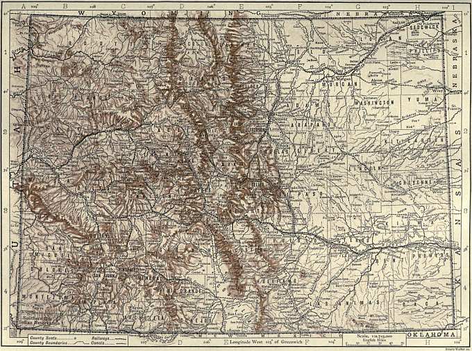
(Click to enlarge.)
The public school system of Colorado dates from 1861, when a school law was passed by the Territorial legislation; this law was superseded by that of 1876, which with subsequent amendments is still in force. In expenditure for the public schools per capita of total population from 1890 to 1903 Colorado was one of a small group of leading states. In 1906 there were 187,836 persons of school age (from 6 to 21) in the state, and of these 144,007 were enrolled in the schools; the annual cost of education was $4.34 per pupil. In 1902-1903, 92.5% of persons from 5 to 18 years of age were enrolled in the schools. The institutions of the state are: the University of Colorado, at Boulder, opened 1877; the School of Mines, at Golden (1873); the Agricultural College, at Fort Collins (1870); the Normal School (1891) at Greeley; and the above-mentioned industrial schools. All are supported by special taxes and appropriations—the Agricultural College receiving also the usual aid from the federal government. Experiment stations in connexion with the college are maintained at different points. Colorado College (1874) at Colorado Springs, Christian but not denominational, and the University of Denver, Methodist, are on independent foundations. The United States maintains an Indian School at Grand Junction.
History.—According as one regards the Louisiana purchase as including or not including Texas to the Rio Grande (in the territorial meaning of the state of Texas of 1845), one may say that all of Colorado east of the meridian of the head of the Rio Grande, or only that north of the Arkansas and east of the meridian of its head, passed to the United States in 1803. At all events the corner between the Rio Grande and the Arkansas was Spanish from 1819 to 1845, when it became American territory as a part of the state of Texas; and in 1850, by a boundary arrangement between that state and the federal government, was incorporated in the public domain. The territory west of the divide was included in the Mexican cession of 1848. Within Colorado there are pueblos and cave dwellings commemorative of the Indian period and culture of the south-west. Coronado may have entered Colorado in 1540; there are also meagre records of indisputable Spanish explorations in the south in the latter half of the 18th century (friars Escallante and Dominguez in 1776). In 1806 Zebulon M. Pike, mapping the Arkansas and Red rivers of the Louisiana Territory for the government of the United States, followed the Arkansas into Colorado, incidentally discovering the famous peak that bears his name. In 1819 Major S. H. Long explored the valleys of the South Platte and Arkansas, pronouncing them uninhabited and uncultivable (as he also did the valley of the Missouri, whence the idea of the “Great American Desert”). His work also is commemorated by a famous summit of the Rockies. There is nothing more of importance in Colorado annals until 1858. From 1804 to 1854 the whole or parts of Colorado were included, nominally, under some half-dozen territories carved successively out of the Trans-Mississippi country; but not one of these had any practical significance for an uninhabited land. In 1828 (to 1832) a fortified trading post was established near La Junta in the Arkansas valley on the Santa Fé trail; in 1834-1836 several private forts were erected on the Platte; in 1841 the first overland emigrants to the Pacific coast crossed the state, and in 1846-1847 the Mormons settled temporarily at the old Mexican town of Pueblo. John C. Frémont had explored the region in 1842-1843 (and unofficially in later years for railway routes), and gave juster reports of the country to the world than his predecessors. Commerce was tributary in these years to the (New) Mexican town of Taos.
Colorado was practically an unknown country when in 1858 gold was discovered in the plains, on the tributaries of the South Platte, near Denver. In 1859 various discoveries were made in the mountains. The history of Denver goes back to this time. Julesburg, in the extreme north-east corner, at the intersection of the Platte valley and the overland wagon route, became transiently important during the rush of settlers that followed. Emigration from the East was stimulated by the panic and hard times following 1857. During 1860, 1861 and 1862 there was a continuous stream of immigration. Denver (under its present name), Black Hawk, Golden, Central City, Mount Vernon and Nevada City were all founded in 1859; Breckenridge, Empire, Gold Hill, Georgetown and Mill City date from 1860 and 1861. The political development of the next few years was very complicated. “Arapahoe County,” including all Colorado, was organized as a part of Kansas Territory in 1858; but a delegate was also sent to Congress to work for the admission of an independent territory (called “Jefferson”). At the same time, early in 1860, a movement for statehood was inaugurated, a constitution being framed and submitted to the people, who rejected it, adopting later in the year a constitution of territorial government. Accordingly the Territory of Jefferson arose, assuming to rule over six degrees of latitude (37°-43°) and eight of longitude (102°-110°). Then there was the Kansas territorial government also, and under this a full county organization was maintained. Finally, peoples’ court, acting wholly without reference to Kansas, and with no more than suited them (some districts refusing taxes) to the local “provisional” legislature, secured justice in the mining country. The provisional legislature of the Territory of Jefferson maintained a wholly illegal but rather creditable existence somewhat precariously and ineffectively until 1861. Its acts, owing to the indifference of the settlers, had slight importance. Some, such as the first charter of Denver, were later re-enacted under the legal territorial government, organized by the United States in February 1861. Colorado City was the first capital, but was soon replaced by Golden, which was the capital from 1862 until 1868, when Denver was made the seat of government (in 1881 permanently, by vote of the people). In 1862 some Texas forces were defeated by Colorado forces in an attempt to occupy the territory for the Confederacy. From 1864 to 1870 there was trouble with the Cheyenne and Arapahoe Indians. A sanguinary attack on an Indian camp in Kiowa county in 1864 is known as the Sand Creek Massacre. In 1867 the Republican party had prepared for the admission of Colorado as a state, but the enabling act was vetoed by President Johnson, and statehood was not gained until 1876. Finally, under a congressional enabling act of the 3rd of March 1875, a constitution was framed by a convention at Denver (20th of December 1875 to 14th of March 1876) and adopted by the people on the 1st of July 1876. The admission of Colorado to the Union was thereupon proclaimed on the 1st of August 1876.
From this time on the history of the state was long largely that of her great mining camps. After 1890 industrial conditions were confused and temporarily set greatly backward by strikes and lockouts in the mines, particularly in 1894, 1896-1897 and 1903-1904, several times threatening civil war and necessitating the establishment of martial law. Questions of railways, of franchises, union scales and the recognition of the union in contracts, questions of sheep and cattle interests, politics, civic, legal and industrial questions, all entered into the economic troubles of these years. The Colorado “labour wars” were among the most important struggles between labour and capital, and afforded probably the most sensational episodes in the story of all labour troubles in the United States in these years. A state board of arbitration was created in 1896, but its usefulness was impaired by an opinion of the state attorney-general (in 1901) that it could not enforce subpoenas, compel testimony or enforce decisions. A law establishing an eight-hour day for underground miners and smelter employees (1899) was unanimously voided by the state supreme court, but in 1902 the people amended the constitution and ordered the general assembly to re-enact the law for labourers in mines, smelters and dangerous employments. Following the repeal of the Sherman Law and other acts and tendencies unfavourable to silver coinage in 1893 and thereafter, the silver question became the dominant issue in politics, resulting in the success of the Populist-Democratic fusion party in three successive elections, and permanently and greatly altering prior party organizations.