VOLUME II SLICE V Arculf to Armour, Philip (continued 10)
Reading edition
Fauna and Flora.—Within the borders of Arizona are areas representative of every life zone save the humid tropical. From the summit of the San Francisco Mountains one may pass rapidly through all these down into the Painted Desert. The Boreal-Canadian, Transition and Upper Sonoran embrace the highlands. Coyotes are very common; wild cats and mountain lions are fairly plentiful. Deer and antelope are represented by various species. Prairie-dogs, jack-rabbits, crows and occasional ravens, quail, grouse, pheasants and wild turkeys are also noteworthy in a rather scant animal life. Characteristic forms of the Upper Sonoran zone are the burrowing owl, Nevada sage-thrush, sage-thrasher and special species of orioles, kangaroo rats, mice, rabbits and squirrels. The Lower Sonoran covers the greatest part of southern and western Arizona, as well as the immediate valleys of the Colorado and Little Colorado rivers. Its animal life is in the main distinguished in species only from that of the Upper Sonoran belt, including among birds, the desert sparrow, desert thrasher, mocking-bird, hooded oriole; and among mammals small nocturnal species of kangaroo rats, pocket mice, mice and bats. Jaguars occasionally stray into Arizona from Mexico. Lizards and toads are conspicuous in the more desert areas. Snakes are not numerous. The Gila-monster, tarantula, the scorpion and thelyphonus, scolopender and julus occur in some localities in the rainy season. The Arid-Tropical zone is represented by a narrow belt along the lower Colorado river, with a short arm extending into the valley of the Gila. The country is so arid that it supports only desert birds and mammals. Camels were very successfully employed as pack animals on the Tule desert in the palmy days of Virginia City, Nevada, before the advent of railways.
The general conditions of distribution of the fauna of Arizona are shown even more distinctly by the flora. There are firs and spruces on the mountains, characteristic of the Boreal zone; pines characteristic of the Transition zone; piñon juniper, greasewood and the universally conspicuous sage-brush, characteristic of the Upper Sonoran zone. In the Lower Sonoran belt, soapweed, acacias (Palo Verde or Parkinsonia torreyana), agaves, yuccas and dasylirions, the creosote bush and mesquite tree, candle wood, and about seventy-five species of cactuses—among them omnipresent opuntiae and great columnar “Chayas”—make up a striking vegetation, which in its colours of dull grey and olive harmonizes well with the rigidity and forbidding barrenness of the plains. It has exercised profound influence upon the industries, arts, faiths and general culture of the Indians. In places the giant cactus grows in groves, attaining a height of 40 and even 50 ft. The mesquite varies in size from a tangled thorny shrub to a spreading tree as much as 3 ft. in diameter and 50 ft. high; it is normally perhaps half as high, and 6-8 in. in diameter. Enduring hardily great extremes of heat and moisture, it is throughout the arid South-west the most important, and in many localities the only important, native tree. From the great juicy, leafless, branchless stalk of the yucca, soap is prepared, and strong fibres useful in making paper, rope and fabrics. The fibre of the agave is also made into rope and its juice into pulque. The canaigre grows wild and is also cultivated. It is easy to exaggerate greatly the barrenness of an arid country. There are fine indigenous grasses that spring up over the mesas after the summer rains, furnishing range for live-stock; some are extraordinarily independent of the rainfall. In the most arid regions there is a small growth of green in the rainy season, and a rich display of small wild-flowers, as well as the enormous flower clusters of the yucca, and blooms in pink and orange, crimson, yellow and scarlet of the giant cactus and its fellows. Even in the Mexican border, desert oak, juniper and manzanita cover the mountains, and there is a vigorous though short-lived growth of grasses and flower from July to October. The cliff-dweller country supports a scant vegetation—a few cottonwood in the washes, a few cedars on the mesas.
Continuous forest areas are scant. A fair variety of trees—cottonwood, sycamore, ash, willow, walnut and cherry—grow in thickets in the canyons, and each mountain range is a forest area. Rainfall varying with the altitude, the lower timber line below which precipitation is insufficient to sustain a growth of trees is about 7000 ft., and the upper timber line about 11,500 ft. Oaks, juniper, piñon, cedars, yellow pine, fir and spruce grow on the mountains and over large areas of the plateau country.2 The Coconino forest is one of the largest unbroken pine forests (about 6000 sq. m.) in the United States. Since 1898 about 86% of the wooded lands have been made reservations, and work has been done also to preserve the forest areas in the mountains in the south-east, from which there are few streams of permanent flow to the enclosing arid valleys.
Soil.—The soils in the southern part of Arizona are mainly sandy loams, varying from light loam to heavy, close adobe; on the plateaus is what is known as “mesa” soil; and along the rivers are limited overflow plains of fine sediment—especially along the Colorado and the river Verde. These soils are in general rich, but deficient in nitrogen and somewhat in humus; and in limited areas white alkaline salts are injuriously in excess. Virgin soils are densely compact. By far the most useful crops are leguminous green manures, especially alfalfa, which grows four to seven cuttings in a year and as a soil flocculator and nitrogen-storer has proved of the greatest value. The greatest obstacle to agriculture is lack of water. Artesian wells are much used in the south-east. For the reservation of the water-partings—in the past considerably denuded by lumbermen and ranchmen—the increase of the forest areas, and the creation of reservoirs along the rivers, to control their erratic flow3 and impound their flood waste for purposes of irrigation, much has been done by the national government. The irrigated areas are only little spots along the permanent streams. In 1900 the farm area was only 2.7% of the total area of the state and only 0.31% was actually improved (including Indian reservations, 0.35%; in 1906, 0.92% was cultivated); of the land actually under crops, 88.5% was irrigated. The improved acreage more than quintupled from 1880 to 1900. The total irrigated area in 1900 was 185,000 acres and in 1902, 247,250 acres. The increase in land values by irrigation from 1890 to 1900 is estimated at $3,500,000. A reservoir was begun in 1904 just below the junction of the Tonto and the Salt with capacity to store 1,330,000 acre-ft. for irrigation, and develop also an electric power sufficient to pump underground water for an additional 50,000 acres at the lowest estimate4 of lands lying too high for supply by gravity. Another important undertaking begun about the same time was the throwing of an East Indian weir dam (the only one in the United States) across the Colorado near Yuma, and the confinement of both sides of the lower Gila and Colorado with levees.
Agriculture.—Strawberries and Sahara dates; alfalfa, wheat, barley, corn and sorghum; oranges, lemons, wine grapes, limes, olives, figs, dates, peanuts and sweet potatoes; yams and sugar beets, show the range of agricultural products. The date palm fruits well; figs grow luxuriantly, though requiring much irrigation; almonds do well if protected from spring frosts; sea-island cotton grows in the finest grades, but is not of commercial importance. The country about Yuma is particularly suited to subtropical fruits. Temperate fruits—peaches, pears, apples, apricots and small fruits—do excellently; as do all important vegetables. The fruit industry is becoming more and more important. Farming is very intensive, and crop follows crop in swift succession; in 1905 the yield of barley per acre, 44 bushels, was greater than in any other state or territory, as was the farm price per bushel on the 1st of December, 81 cents; the average yield per acre of hay was the highest in the Union in 1903, 3.46 tons, the general average being 1.54 tons, was fourth in 1904, 2.71 tons (Utah 3.54, Idaho 3.07, Nevada 3.04), the general average being 1.52 tons, and was highest in 1905, 3.75 tons, the general average for the country being 1.54 tons; and in the same three years the average value per acre of hay was greater in Arizona than in any other state of the Union, being $35.78 in 1903, $40.22 in 1904, and $46.39 in 1905, the general averages for the country being $13.93, $13.23 and $13.11 respectively, for the three years. Of the total farm acreage of the state 97.6% were held in 1900 by the whites; and of these 80.2% owned in whole or in part the land they cultivated.
Stock-raising is a leading industry, but it has probably attained its full development. The over-stocking of the ranges has caused much loss in the past, and the almost total eradication of fine native grasses over extended areas. Of the neat cattle (7,042,635) almost 98%, and of the sheep (861,761) almost 100%, were in 1900 pastured wholly or in part upon the public domain. The extension of national forest reserves and the regulations enforced by the United States government for the preservation of the ranges have put limits to the industry. In 1900 the value of live-stock represented 15.7% of the capital invested in agriculture; the value of animals sold or slaughtered for food ($3,204,758) was half the total value of all farm products ($6,997,097). Ostrich farms have been successfully established in the Salt river valley since 1893; in 1907 there were six farms in the Salt river valley, on which there were about 1354 birds; the most successful food for the ostrich is alfalfa.
Minerals.—Mining is the leading industry of Arizona. Contrary to venerable traditions there is no evidence that mining was practised beyond the most inconsiderable extent by aborigines, Spanish conquistadores, or Jesuits. In 1738 an extraordinary deposit of silver nuggets, quickly exhausted (1741), was discovered at Arizonac. At the end of the 18th century the Mexicans considerably developed the mines in the south-east. The second half of the 19th century witnessed several great finds; first, of gold placers on the lower Gila and Colorado (1858-1869); later, of lodes at Tombstone, which flourished from 1879-1886, then decayed, but in 1905 had again become the centre of important mining interests; and still later the development of copper mines at Jerome and around Bisbee. Several of the Arizona copper mines are among the greatest of the world. The Copper Queen at Bisbee from 1880-1902 produced 378,047,210 ℔ of crude copper, which was practically the total output of the territory till after 1900, when other valuable mines were opened; the Globe, Morenci and Jerome districts are secondary to Bisbee. Important mines of gold and silver, considerable deposits of wolframite, valuable ores of molybdenum and vanadium, and quarries of onyx marble, are also worked. Low-grade coal deposits occur in the east central part of the state and near the junction of the Gila and San Pedro rivers. Some fine gems of peridot, garnet and turquoise have been found. The mineral products of Arizona for 1907 were valued at $56,753,650; of which $51,355,687 (more than that of any other state) was the value of copper; $2,664,000, gold; and $1,916,000, silver. In 1907 the legislature passed an elaborate act providing for the taxation of mines, its principal clause being that the basis of valuation for taxation in each year be one-fourth of the output of the mines in question for the next preceding year.
Manufactures.—The manufacturing industries are of relatively slight importance, though considerable promise attends the experiments with canaigre as a source of tannin. The Navaho and Moqui Indians make woollen blankets and rugs and the Pimas baskets. Onyx marbles of local source are polished at Phoenix. The capital invested in manufacturing industries increased from $9,517,573 in 1900 to $14,395,654 in 1905, or 51.3%, and the value of products from $20,438,987 in 1900 to $28,083,192 in 1905, or 37.4%. Of the total product in 1905 the product of the principal industry, the smelting and refining of copper ($22,761,981), represented 81.1%; it was 9.4% of all the smelting and refining of copper done in the United States in that year. The other manufactures were of much less importance, the principal ones being cars and general shop construction, including repairs by steam railway companies ($1,329,308), lumber and timber products ($960,778), and flour and grist mill products ($743,124).
Two transcontinental railway systems, the Southern Pacific and Santa Fe, were built across Arizona in 1878-1883. They are connected by one line, and a feeder runs S. into Sonora. The railway mileage of Arizona on the 1st of January 1908 was 1935.35 m.
Population.—The population of Arizona in 1880 was 40,440; in 1890, 59,620; in 1900, 122,931 (including 28,623 reservation Indians not counted before); in 1910, 204,354. The native population is of the most diverse origin; the foreign element is equally heterogeneous, but more than half (in 1900, 14,172 out of 24,283 foreign-born) are Mexicans, many of whom are not permanent residents; after 1900, immigrants were largely mine labourers, and included Slavonians and Italians. The largest towns in 1900 were Tucson, Phoenix, which is the capital, Prcscott (pop. 3559), Jerome (pop. 1890, 250; in 1900, 2861); Winslow (pop. 1890, 363; in 1900, 1305), Nogales (pop. 1900, 1761), and Bisbee. The last was an insignificant mining camp in 1880, still unincorporated in 1900, but with an estimated population of 6000 in 1904. It is crowded picturesquely into several narrow confluent ravines. Railway connexion with El Paso was established in 1902. Douglas is another growing camp.
Over thirty Indian tribes are represented in the Indian schools of Arizona. The more important are the Hualapais or Apache-Yumas; the Mohaves; the Yavapais or Apache-Mohaves; the Yumas, whose lesser neighbours on the lower Colorado are the most primitive Indians of the United States in habits; the Maricopas; the Pimas and Papagoes, who figure much in early Arizona history, and who are superior in intelligence, adaptability, application and character; the Hopis or Moquis, possessed of the same good qualities and notably temperate and provident, famous for their prehistoric culture (Tusuyan); the Navaho, and the kindred Apaches, perhaps the most relentless and savage of Indian warriors. All the Indians of Arizona live on reservations save the few non-tribal Indians taxed and treated as active citizens. Even the Apaches after being whipped by relentless war into temporary submission have been bound by treaties which the gifts, vices and virtues of the reservation system have tempted them to observe. The Pimas and Papagoes were early converted by the Spaniards, and retain to-day a smattering of Christianity plentifully alloyed with paganism. Apaches, Pimas, Papagoes have been employed by the United States on great irrigation works, and have proved industrious and faithful labourers. In 1900 there were 1836 taxed Indians, 26,480 reservation Indians not taxed, and in addition many friendly Papagoes unenumerated.
In 1906 the Indian population was estimated as being 14% of the whole population of Arizona, and that they are singularly law-abiding is argued from the fact that in the same year the Indians furnished only 3% of the convicts in the territorial prison.
Government and Education.—Arizona became a territory of the first (or practically autonomous) class in 1863. Her organic law thereafter until 1910 consisted of various sections of the Revised Statutes of the United States. From the beginning she had a territorial legislature. Congress retained ultimately direct control of all government, administration being in the hands of resident officials appointed by the president and Senate. Special mention must be made of the secret police, the Arizona Rangers, organized in 1901 to police the cattle ranges; they are “fearless men, trained in riding, roping, trailing and shooting,” a force whose personnel is not known to the general public. The legislature repealed the law licensing public gambling in 1907; enacted a law requiring the payment of $300 per annum as licence fee by retail liquor dealers; and provided for juvenile courts and probationary control of children. In 1907 the total tax valuation of property was $77,705,251; the net debt of the territory $1,022,972, and that of counties and towns $3,123,275. The receipts of the territorial treasury for the year ending on the 30th of June 1907 were $687,386, and the disbursements for the same period were $601,568. A homestead provision (1901) exempts from liability for debts (except mortgages or liens placed before the homestead claim) any homestead belonging to the head of a family, existing in one compact body and valued at not more than $2500; such a homestead a married man may not sell, lease or put a lien on without his wife’s consent. Personal property to the value of $500 is exempt from the same liability. The public school system was established in 1871. A compulsory attendance law applies to children between 6 and 14 years of age, but it is not generally obeyed by the Mexican element of population. In 1907 there was an enrolment of 24,962 out of 33,167 children of school age; there were six high schools—three new in 1906; and the average number of school days was 128.4. In the fiscal year ending June 1907, the total receipts for schools were $697,762, and the expenditures were $701,102. Illiteracy is high, amounting in 1900 to 23.1% of native males, above 21 years of age, and 30.5% of foreign males, principally because of the large number of Indians, Chinese, Japanese and Mexicans in the state. There are two normal schools at Tempe (1886) and Flagstaff (1899), a university at Tucson with an agricultural experiment station that has done much for the industries of Arizona; there is a considerable number of Indian schools, the largest of which are maintained by the national government, and the funds of the university come largely from the same source. The first juvenile reform school, called the Territorial Industrial school, was opened in 1903 at Benson. The territorial prison, formerly at Yuma, was abandoned for a modern building at Florence, Pinal county; and a hospital for the insane is 3 m. from Phoenix.
History.—The history of the South-west is full of interest to the archaeologist. A prehistoric culture widely distributed has left abundant traces. Pueblo ruins are plentiful in the basins of the Gila and Colorado rivers and their tributaries. Geographical conditions and a hard struggle against nature fixed the character of this “aridian” culture, and determined its migrations; the onslaughts of nomad Indians determined the sedentary civilization of the cliff dwellers. A co-operative social economy is evidenced by the traces of great public works, such as canals many miles in length. The pueblos of the Gila valley are held to be older than those of the Colorado. Casa Grande, 15 m. S.E. of a railway station of the same name on the Southern Pacific railway, is the most remarkable of plain ruins in the South-west, the only one of its type in the United States. It resembles the Casa Grande ruin of Chihuahua, Mexico, with its walls of sun-dried puddled clay, and its area of rooms, courts and plazas, surrounded by a wall. It was already a ruin when discovered in 1694 by the Jesuit father Kino. John Russel Bartlett described it in 1854, and in 1889 Congress voted that it be protected as a government reservation; in 1892 it was set apart by the government. Excavations were made there in 1906-1907 by Dr J. Walter Fewkes. Migration was northward. The valleys of the Salt river and its affluents, the Agua Fria, Verde and Tonto, are strewn with aboriginal remains; but especially important in migrations of culture was the Little Colorado. A very considerable population must have lived once in this valley. It is represented to-day by the still undeserted habitats of Zuñi (in New Mexico) and Tusayan; the Moquis, after the Zuñis, are in customs and traditions the best survival of the ancient civilization.
Arizona north of the Gila, save for a very limited and intermittent missionary effort and for scant exploring expeditions, was practically unknown to the whites until well after the beginning of American rule. The Santa Cruz valley, however, has much older annals of a past that charms by its picturesque contrasts with the present. Arizona history begins with the arrival in Sonora in 1536 of Alvar Nuñez Cabeza de Vaca, who, although he had not entered Arizona or New Mexico, had heard of them, and by his stories incited the Spaniards to explore the unknown north in hope of wealth. Marcos de Niza, a Franciscan friar to whom the first reconnaissance was entrusted, was the first Spaniard to enter the limits of Arizona. He crossed the south-eastern corner to Zuñi in 1539, passing through the Santa Cruz valley; and F.V. de Coronado (q.v.) was led by Fray Marcos over the same route in 1540; while Hernando Alarcon explored the Gulf of California and the lower Colorado river. Members of Coronado’s expedition explored the Moqui country and reached the Grand Canyon, and after this a succession of remarkable and heroic explorations followed through the century; which however accomplished little for geography, further confusing and embellishing rather than clearing up its mysteries. All this has left traces in still living myths about the early history of the South-west. Early in the 17th century considerable progress had been made in Christianizing the Pimas, Papagoes and Moquis. Following 1680 came a great Indian revolt in New Mexico and Arizona, and thereafter the Moquis remained independent of Spanish and Christian domination, although visited fitfully by rival Jesuits and Franciscans. In 1732 (possibly in 1720) regular Jesuit missions were founded at Bac (known as an Indian rancheria since the 17th century) and at Guevavi. The region south of the Gila had already been repeatedly explored. In the second half of the century there was a presidio at Tubac (whose name first appears 1752) and some half-dozen pueblos de visita, including the Indian settlement of Tucson.
A few errors should be corrected and some credit given with reference to this early period. The Inquisition never had any jurisdiction whatever over the Indians; compulsory labour by the Indians was never legalized except on the missions, and the law was little violated; they were never compelled to work mines; of mining by the Indians for precious metals there is no evidence; nor by the Jesuits (expelled in 1767, after which their missions and other properties were held by the Franciscans), except to a small extent about the presidio of Tubac, although they did some prospecting. Persistent traditions have greatly exaggerated the former prosperity of the old South-west. The Spaniards probably provoked some inter-tribal intercourse among the Indians, and did something among some tribes for agriculture. Their own farms and settlements, save in the immediate vicinity of the presidio, were often plundered and abandoned, and such settlement as there was was confined to the Santa Cruz valley. From about 1790 to 1822 was a period of peace with the Apaches and of comparative prosperity for church and state. The fine Indian mission church at Bac, long abandoned and neglected, dates from the last decade of the 18th century. The establishment of a presidio at Tucson in 1776 marks its beginning as a Spanish settlement.
The decay of the military power of the presidios during the Mexican war of independence, the expulsion of loyal Spaniards—notably friars—and the renewal of Apache wars, led to the temporary abandonment of all settlements except Tubac and Tucson. The church practically forsook the field about 1828.
American traders and explorers first penetrated Arizona in the first quarter of the 19th century. As a result of the Mexican War, New Mexico, which then included all Arizona north of the Gila, was ceded to the United States. California gold discoveries drew particular attention to the country south of the Gila, which was wanted also for a transcontinental railway route. This strip, known as the “Gadsden Purchase” (see Gadsden, James), was bought in 1854 by the United States, which took possession in 1856. This portion was also added to New Mexico. The Mexicans, pressed by the Apaches, had, in 1848, abandoned even Tubac and Tamacácori, first a visita of Guevavi, and after 1784 a mission. The progress of American settlement was interrupted by the Civil War, which caused the withdrawal of the troops and was the occasion for the outbreak of prolonged Indian wars.
Meanwhile a convention at Tucson in 1856 sent a delegate to Congress and petitioned for independent territorial government. This movement and others that followed were ignored by Congress owing to its division over the general slavery question, and especially the belief of northern members that the control of Arizona was an object of the pro-slavery party. A convention held in April 1860 at Tucson undertook to “ordain and establish,” of its own motion, a provisional constitution until Congress should “organize a territorial government.” This provisional territory constituted all New Mexico south of 34° 40′ N. Officials were appointed and New Mexican legislation for the Arizona counties ignored, but nothing further was done. In 1861 it was occupied by a Texan force, declared for the Confederacy, and sent a delegate (who was not admitted) to the Confederate congress. That body in January 1862 passed a formal act organizing the territory, including in it New Mexico, but in May 1862 the Texans were driven out by a Union force from California. By act of the 24th of February 1863 Congress organized Arizona territory as the country west of 109° W. long. In December an itinerant government sent out complete from Washington crossed the Arizona line and effected a formal organization. The territorial capital was first at Prescott (1863-1867), then at Tucson (1867-1877), again at Prescott (1877-1889), and finally at Phoenix (since 1889).
There have been boundary difficulties with every contiguous state or territory. The early period of American rule was extremely unsettled. The California gold discoveries and overland travel directed many prospecting adventurers to Arizona. For some years there was considerable sentiment favouring filibustering in Sonora. The Indian wars, breeding a habit of dependence on force, and the heterogeneous elements of cattle thieves, Sonoran cowboys, mine labourers and adventurers led to one of the worst periods of American border history. But since about 1880 there is nothing to chronicle but a continued growth in population and prosperity. Agitation for statehood became prominent in territorial politics for some years. In accordance with an act of Congress, approved on the 16th of June 1906, the inhabitants of Arizona and New Mexico voted on the 6th of November 1906 on the question of uniting the territories into a single state to be called Arizona; the vote of New Mexico was favourable to union and statehood, but these were defeated by the vote of Arizona (16,265 against, and 3141 for statehood). In June 1910 the President approved an enabling act providing for the admission of Arizona and New Mexico as separate states.
Bibliography.—For the Colorado river and the Grand Canyon see those articles; for the Sonoran boundary region, Report of the Boundary Commission upon the Boundaries between the United States and Mexico (3 vols., Washington, 1898-1899, also as Senate Document No. 247, vols. 23-25, 55 Congress, 2 Session); for the petrified forest of the Painted Desert, L.F. Ward in Smithsonian Institution Annual Rep., 1899; for the rest of the area, various reports in the U.S. Geological Survey publications, bibliography in Bulletin Nos. 100, 177.—Fauna and Flora: U.S. Department of Agriculture, North American Fauna, No. 3 (1890), No. 7 (1893); U.S. Biological Survey, Bulletin No. 10 (1898); publications of the Desert Botanical Laboratory at Tucson; also titles under archaeology below, particularly Bandelier’s “Final Report.”—Climate, Soil, Agriculture: U.S. Department of Agriculture, Climate and Crop Service, Arizona, monthly reports, annual summaries; Arizona Agricultural Experiment Station, Bulletins.—Mineral Industries: U.S. Geological Survey publications, consult bibliographies; The Mineral Industry, annual (New York and London).—Government: Arizona Revised Statutes (Phoenix, 1887); Report of the Governor of Arizona Territory to the Secretary of the Interior, annual.—Archaeology: An abundance of materials in the Annual Report, U.S. Bureau of Ethnology for different years; consult also especially A.F.A. Bandelier, “Contributions to the History of the South-western Portion of the United States,” in Archaeological Institute of America, Papers, American Series, vol. 5 (Cambridge, 1890); “Final Report of Investigations among the Indians of the South-western United States,” ib. vols. 3 and 4 (Cambridge, 1890-1892); other material may be found in Smithsonian Institution, Annual Report, 1896, 1897, &c., and many important papers by J.W. Fewkes, F.W. Hodge, C. Mendeleff and others in the American Anthropologist and Journal of American Ethnology.—History: H.H. Bancroft, History of Arizona and New Mexico (San Francisco, 1887); A.F.A. Bandelier, “Historical Introduction to Studies among the Sedentary Indians of New Mexico,” in Archaeological Institute of America, Papers, American Series, vol. 1 (Boston, 1881); The Gilded Man (El Dorado) and other Papers (New York, 1893); G.P. Winship, “The Coronado Expedition,” in U.S. Bureau of Ethnology, 14th Annual Report (1892-1893), pp. 339-613, with an abundant literature to which this may be the guide. The traditional errors respecting the early history of the Spanish South-west are fully exposed in the works of Bancroft and Bandelier, whose conclusions are supported by E. Coues, On the Trail of a Spanish Pioneer, Francisco Garcés (2 vols. New York, 1900).
1 At Yuma, Phoenix and Tucson, the records of twenty-six, eighteen and fifteen years respectively show a rate of evaporation 35.2, 12.7, and 7.7 times as great as the mean annual rainfall, which was 2.84 in., 7.06 in. and 11.7 in. for the places named.
2 The San Francisco yellow pine forest, with an area of some 4700 sq. m., is the finest forest of the arid south-west.
3 The combined flow of the Salt and Verde varies from 100 to more than 10,000 cub. ft. per second.
4 The dam locks a narrow canyon. The height is 284 ft., the water rising 230 ft. against it. The storage capacity is exceeded by probably but one reservoir in the world—the Wachusett reservoir near Boston.
ARJUNA, in Hindu mythology, a semi-divine hero of the Mahabharata. He was the third son of Pandu, son of Indra, His character as sketched in the great epic is of the noblest kind. He is the central figure of that portion of the epic known as the Bhagwad-gita, where he is represented as horrified at the impending slaughter of a battle and as being comforted by Krishna.
ARK (a word common to Teutonic languages, cf. Ger. Arche, adapted from the Lat. arca, chest, cf. arcere, to shut up, enclose), a chest, basket or box. The Hebrew word tebah, translated in the A.V. by “ark,” is used in the Old Testament (1) of the box made of bulrushes in which Pharaoh’s daughter found the infant Moses (Exodus ii. 3), and (2) of the great vessel or ship in which Noah took refuge during the flood (Genesis vi.-ix.).
Noah’s Ark.—According to the story in Genesis, Noah’s ark was large enough to contain his family and representatives of each kind of animal. Its dimensions are given as 300 cubits long, 50 cubits broad and 30 cubits high (cubit = 18-22 in.). It was made of “gopher” wood, which has been variously identified with cypress, pine and cedar. Before the days of the “higher criticism” and the rise of the modern scientific views as to the origin of species, there was much discussion among the learned, and many ingenious and curious theories were advanced, as to the number of the animals and the space necessary for their reception, with elaborate calculations as to the subdivisions of the ark and the quantities of food, &c., required to be stored. It may be interesting to recall the account given in the first edition of the Encyclopaedia Britannica (1771), which contained a summary of some of these various views (substantially repeated up to the publication of the eighth edition, 1853). “Some have thought the dimensions of the ark as given by Moses too scanty ... and hence an argument has been drawn against the authority of the relation. To solve this difficulty many of the ancient Fathers and the modern critics have been put to miserable shifts. But Buteo and Kircher have proved geometrically that, taking the cubit of a foot and a half, the ark was abundantly sufficient for all the animals supposed to be lodged in it. Snellius computes the ark to have been above half an acre in area ... and Dr Arbuthnot computes it to have been 81,062 tuns ... if we come to a calculation the number of species of animals will be found much less than is generally imagined, not amounting to a hundred species of quadrupeds, nor to two hundred of birds.... Zoologists usually reckon but an hundred and seventy species in all.” The progress of the “higher criticism,” and the gradual surrender of attempts to square scientific facts with a literal interpretation of the Bible, are indicated in the shorter account given in the eighth edition, which concludes as follows:—“the insuperable difficulties connected with the belief that all the existing species of animals were provided for in the ark, are obviated by adopting the suggestion of Bishop Stillingfleet, approved by Matthew Poole, Pye Smith, le Clerc, Rossenmüller and others, that the deluge did not extend beyond the region of the earth then inhabited, and that only the animals of that region were preserved in the ark.” The first edition also gives an engraving of the ark (repeated in the editions up to the fifth), in shape like a long roofed box, floating on the waters; the animals are seen in separate stalls. By the time of the ninth edition (1875) precise details are no longer considered worthy of inclusion; and the age of scientific comparative mythology has been reached.
For a comparative study of the occurrence of the ark in the various deluge myths, in the present edition, see Deluge; Cosmogony; Babylonia And Assyria.
The Ark of the Law, in the Jewish synagogue, is a chest or cupboard containing the scrolls of the Torah (Pentateuch), and is placed against or in the wall in the direction of Jerusalem. It forms one of the most decorative features of the synagogue, and often takes an architectural design, with columns, arches and a dome. There is a fine example in the synagogue at Great St Helens, London.
(X.)
Ark of the Covenant, Ark of the Revelation, Ark of the Testimony, are the full names of the sacred chest of acacia wood overlaid with gold which the Israelites took with them on their journey into Palestine. The Biblical narratives reveal traces of a considerable development in the traditions regarding this sacred object, and those which furnish the most complete detail are of post-exilic date when the original ark had been lost. The fuller titles of the ark originate in the belief that it contained the “covenant” (bĕrīth) or “testimony” (‘ēdūth), the technical terms for the Decalogue (q.v.); primarily, however, it would seem to have been called “the ark of Yahweh” (or “Elohim”), or simply “the ark.” The word itself (ārōn) designates an ordinary chest (cp. Gen. i. 26; 2 Kings xii. 10), and the (late) description of its appearance represents it as an oblong box 2½ cubits long, 1½ cubits in breadth and height (roughly 1.2 by .75 metres). It was lined within and without with gold, and through four golden rings were placed staves of acacia wood, by means of which it was carried. A slab of the same metal (the so-called “mercy-seat,” kappōreth, Gr. hilastērion) covered the top, and this was surmounted by two Cherubim (Ex. xxv. 10-22, xxxvii. 1-9). The latter, however, are not mentioned in earlier passages (Deut. x. 1, 3), and would naturally increase the weight of the ark, which, according to 2 Sam. xv. 29, could be carried by two men.
The ark was borne by the Levites (Deut. x. 8), and the latest narratives amplify the statement with a wealth of detail characteristic of the post-exilic interest in this order. (See Levites.) An interesting passage relating the commencement of an Israelite journey vividly illustrates the power of the sacred object. As the ark started, it was hailed with the cry,”Arise, Yahweh, let thine enemies be scattered, let them that hate thee flee from before thee,” and when it came to rest, the cry again rang out,”Return, O Yahweh, to the myriads of families of Israel” (Num. x. 33-36). This saying appears to imply a settled life in Canaan, but both affirm the warlike significance of Yahweh and the ark. Thus it is the permanent pledge of Yahweh’s gracious presence; it guides the people on their journey and leads them to victory. It is no mere receptacle, but a sacrosanct object as much to be feared as Yahweh himself. To presume to fight without it was to invite defeat, and on one notable occasion the Israelites attempted to attack their enemy north of Kadesh without its aid, and were defeated (Num. xiv. 44 sq.). There are many gaps in its history, and although at the crossing of the Jordan and at the fall of Jericho the ark figures prominently (Josh. iii. sq., vi. sq.), it is unaccountably missing in stories of greater national moment. Once it is found at Bethel (Judges xx. 27 sq.). It is met with again at Shiloh, where it is under the care of Eli and his sons, descendants of an ancient family of priests (1 Sam. ii. 28; cp. Josh. xviii. 1). After a great defeat of Israel by the Philistines it was brought into the field, but was captured by the enemy. The trophy was set up in the Philistine temple of Ashdod, but vindicated its superiority by overthrowing the god Dagon. A plague smote the city, and when it was removed to Ekron, pestilence followed in its wake. After taking counsel the Philistines placed the ark with a votive offering upon a new cart drawn by two cows. The beasts went of their own accord to Beth-shemesh, where it remained in the field of a certain Joshua. Again a disaster happened through some obscure cause, and seventy of the sons of Jeconiah were smitten (1 Sam. vi. 19, R.V., margin). Thence it was removed to the house of Abinadab of Kirjath-jearim, who consecrated his son to its service (1 Sam. iv.-vii. 1). For many years the ark remained untouched—apparently forgotten. Shiloh disappears from history; neither Saul nor even Samuel, whose youth had been spent with it, takes any further thought of it. After a remarkable period of obscurity, the ark enters suddenly into the history of David (2 Sam. vi.). Some time after the capture of Jerusalem the ark was brought from Baal-Judah, but at the threshing-floor of Nacon (an unintelligible name) Abinadab’s son Uzzah laid hands upon it and was struck down for his impiety. On this account the place is said to have received the name Perez-Uzzah (“breach of Uzzah”). It was taken into the house of Obed-edom the Gittite (i.e. of Gath), and brought a blessing upon his house during the three months that it remained there. Finally the king had it conveyed to the city of David, where a tent was prepared to shelter it. Once at Jerusalem, it seems to have lost its unique value as the token of Yahweh’s presence; its importance was apparently merged with that of the Temple which Solomon built. The foundation of the capital would pave the way for the belief that the national god had taken a permanent dwelling-place in the royal seat. The prophets themselves lay no weight upon the ark as the central point of Jerusalem’s holiness. The real Deuteronomic code does not mention it, and to Jeremiah (iii. 16) it was a thing of no consequence. Later, in the age of the priestly schools, the ark received much attention, although it must obviously be very doubtful how far a true recollection of its history has survived. But nowhere is any light thrown upon its fate. The invasion of Shishak, the capture of Jerusalem by Joash (2 Kings xiv. 13, 14), the troublous reign of Manasseh, the destruction of Jerusalem by Nebuchadrezzar, have found each its supporters. The wild legends of its preservation at the taking of Jerusalem (2 Macc. ii. and elsewhere) only show that the popular mind was unable to share the view that the ark was an obsolete relic. More poetical is the tradition that the ark was raised to heaven, there to remain till the coming of the Messiah, a thought which embodies the spiritual idea that a heavenly pledge of God’s covenant and faithfulness had superseded the earthly symbol.1
A critical examination of the history of the Israelite ark renders it far from certain that the object was originally the peculiar possession of all Israel. Many different traditions have gathered around the story of the Exodus, and the ark was not the only divinely sent guide or forerunner which led the Israelites. Its presence at Shiloh, and its prominence in the life of Joshua, support the view that it was the palladium of the Joseph tribes, but the traditions in question conflict with others. The account of the commencement of the ark’s journey associates it with Moses and his kin (Num. x. 29 sqq.)—that is, with the south Palestinian clans with which the term “Levites” appears to be closely connected. (See Levites.) A distinct movement direct into Judah is implied by certain old traditions (see Caleb), but this is subordinated to the more comprehensive account of the journey round by the east of the Jordan. (See Exodus, The.) The narratives in 1 Sam. iv.-vi. stand on a plane by themselves, and the gap between them and 2 Sam. vi. has not been satisfactorily fixed. But it is not certain that the two belong to the same cycle of tradition; Kirjath-jearim and Baal-Judah are identified only in later writings, and the behaviour of Saul’s daughter (2 Sam. vi. 15 sqq.) may conceivably imply that the ark was an unknown object to Benjamites. It is of course possible that the ark was originally the sacred shrine of the clans which came direct to Judah, and that the traditions in 1 Sam. iv.-vi., Josh. iii. sqq. are of secondary origin, and are to be associated with its appearance at Shiloh, the fall of which place, although attributed to the time of Samuel, is apparently regarded by Jeremiah (xxvi. 6) as a recent event. Of these two divergent traditions, it would seem that the one which associates it with the kin of Moses and David may be traced farther in those late narratives which connect the ark closely with the Levites and even attribute its workmanship to Bezalel, a Calebite (Ex. xxxi. 2; 1 Chron. ii. 19 sqq.). The tradition in Psalms cxxxii. 6 of the search for the ark at Jaar (Kirjath-jearim) and Ephratah is not clear; but a comparison with 1 Chron. ii. 50 seems to show that it recognized the “Calebite” origin of the ark.
See, on this, S.A. Cook, Critical Notes on 0. T. History (Index s.v.), and, for other views, Kosters, Theol. Tijd. xxvii. 361 sqq.; Cheyne, Encyc. Bib. “Ark”; G. Westphal, Yahwes Wohnstätten, pp. 55 sqq., 85 sqq. (Giessen, 1908).
Whether the ark originally contained some symbol of Yahweh or not has been the subject of much discussion. Thus, it has been held that it contained stone fetishes (meteoric stones and the like) from Yahweh’s original abode on Sinai or Horeb. As the palladium of the Joseph tribes, it has even been suggested that the bones of Joseph were treasured in the ark. Others have regarded it as an empty portable throne,2 or as a receptacle for sacred serpents (analogies in Frazer, Pausanias, iv. pp. 292, 344). That it contained the tables of the law (Deut. x. 2; 1 Kings viii. 9) was the later Israelite view, and the subsequent development is illustrated in Heb. ix. 4. It is enough to decide that the ark represented in some way or other the presence of Yahweh and that the safety of his followers depended upon its security (analogies in Frazer, Paus. x. p. 283). The Semitic world affords many examples of the belief that a man’s religion was part of his political connexion and that the change of nationality involved change of cult. He who leaves his land to enter another, leaves his god and is influenced by the religion of his new home (1 Sam. xxvi. 19; Ruth i. 16 sqq.), but strangers know not “the cult of the God of the land” (2 Kings xvii. 26). No nation willingly changes its god (Jer. ii. 11), and there are means whereby the follower of Yahweh may continue his worship even when outside Yahweh’s land (2 Kings v. 17). When a people migrate they may take with them their god, and if they conceive him to be a spiritual being who cannot be represented by an image, they may desire a symbolical expression of or, rather, a substitute for his presence. Accordingly the conception of the ark must be based in the first instance upon the beliefs of the particular clans or tribes whose sacred object it was.
See further, W.R. Smith, Religion of the Semites, p. 37; Schwally, Kriegsaltertümer, i. p. 9; Revue biblique (1903), pp. 249 sqq.; and on the ark, generally, in addition to the literature already cited, Kautzsch, Hastings’ Dict. Bible, v. p. 628; A.R.S. Kennedy, Century Bible: Samuel (Appendix); E. Meyer, Die Israeliten, Index s.v. “Lade,”; and R.H. Kennett, Enc. of Rel. and Ethics.
(S. A. C.)
1 Cp. Rev. xi. 19, and W.R. Smith, Old Test. in Jew. Church, Index. For later traditional material, see Buxtorf, De Arca Foederis (Basel, 1659).
2 But see Budde, Expos. Times (1898), pp. 398 sqq.; Theolog. Stud. u. Krit. (1906), pp. 489-507. The possibility must be conceded that there were several arks in the course of Hebrew history and that separate tribes or groups of tribes had their own sacred object.
ARKANSAS, a river of the United States of America, rising in the mountains of central Colorado, near Leadville, in lat. 39° 20′ N., long. 106° 15′ W., and emptying into the Mississippi, at Napoleon, Arkansas, in lat. 33° 40′ N. Its total length is about 2000 m., and its drainage basin (greater than that of the Upper Mississippi) about 185,000 sq. m. It is the greatest western affluent of the Missouri-Mississippi system. It rises in a pocket of lofty peaks at an altitude of 10,400 ft. on a sharply sloping plateau, down which it courses as a mountain torrent, dropping 4625 ft. in 120 m. At Canyon City it passes out of the Rockies through the Grand Canyon of the Arkansas; then turning eastward, and soon a turbid, shallow stream, depositing its mountain detritus, it flows with steadily lessening gradient and velocity in a broad, meandering bed across the prairies and lowlands of eastern Colorado, Kansas, Oklahoma and Arkansas, shifting its direction sharply to the south-east in central Kansas. The Arkansas ordinarily receives little water from its tributaries save in time of floods. In topography and characteristics and in the difficulties of its regulation the Arkansas is in many ways typical of the rivers in the arid regions of the western states. The gradient below the mountains averages 7.5 ft. per mile between Canyon City and Wichita, Kansas (543 m.), about 1.5 ft. between Wichita and Little Rock (659 m.), and 0.65 of a foot from Little Rock to the mouth (173 m.). The shores are sand, clay or loam throughout some 1300 m., with very rare rock ridges or rapids, and the banks rise low above ordinary water. The waters are constantly rising and falling, and almost never is the discharge at any point uniform. Every year there are, normally, two distinct periods of high water; one an early freshet due mainly to the heavy winter rainfall on the lower river, when the upper river is still frozen hard; the other in the late spring, due to the setting in of rains along the upper courses also, and to the melting of the snow in the mountains. The lowest waters are from August to December. In the summer there are sometimes violent floods due to cloud-bursts. Everywhere along the river there is a never-ending variation of velocity and discharge, and an equally ceaseless transformation of the river’s bed and contour. These changes become revolutionary in times of flood. All these characteristics are accentuated below Little Rock. The depth of water at this point has been known to vary from 27 ft. to only half-a-foot, and the discharge to fall to 1170 cub. ft. per second. There is often no more than 1.5 ft. of water, and far below Little Rock a depth of 3 ft. on crossings is not infrequent. In many places there are different channels for high and low water, the latter being partly filled by each freshet, and recut after each subsidence; and the river meanders tortuously through the alluvial bottom in scores of great bends, loops and cut-offs. It is estimated that the eating and caving of the shore below Little Rock averages 7.64 acres per mile every year (as against 1.99 acres above Little Rock). By way of the White river cut-off the Arkansas finds an additional outlet through the valley of that river in times of high water, and the White, when the current in its natural channel is deadened by the backwaters of the Mississippi, finds an outlet by the same cut-off through the valley of the Arkansas. This backwater, where it meets and checks the current of the Arkansas, occasions the precipitation of enormous alluvial deposits, and vast quantities of snags. The banks are disintegrated along this part of the river and built up again on the opposite side to their original height in the extraordinarily short time of two or three years, the channel remaining all the while narrow. At the mouth of the White, the Arkansas and the Mississippi the level of recurrent floods is 6 or 8 ft. above the timber-bearing soil along the banks, and all along the lower river the country is liable to overflow; and as the land backward from the stream slopes downward from the banks heaped up by successive flood-deposits, each overflow creates along the river a fringe of swamps. These features, although exaggerated in the portion of the river now in question, are qualitatively characteristic of its entire course below the mountains.
Up to the 30th of June 1907 the government of the United States expended $2,384,557 on improvements along the Arkansas. Almost half of this sum was required for snagging operations alone. There is a considerable traffic on the river within the borders of Arkansas in miscellaneous freights, and a slight passenger movement. The river is rarely navigable above Fort Smith, and during a considerable part of the year not above Pine Bluff. Steamer service is maintained the year round between this point and Memphis. Ordinarily there are some 400 m. of channel open to steamers part of the year, and in time of high flood considerably more. To the mouth of the Grand river (460 m.) the river is open about four months in a year for vessels of 4 ft. draft and about eight months for vessels of 2 ft. draft.
Bibliography.—General descriptions of different portions of the river are indicated in the Index to the Reports of the Chief of Engineers, U.S. Army (many volumes, 1879-1900). See also H. Gannett, Profiles of Rivers in the U.S. (U.S. Geolog. Survey, 1901); Greenleaf, “Western Floods,” in Engin. Mag. xii. 945-958; U.S. Geolog. Survey, Bull. 140; I.C. Russell, Rivers of North America (1898); T.J. Vivian, Transportation, Rivers of the Miss. Valley (U.S. Census, 1890, special Rp.).
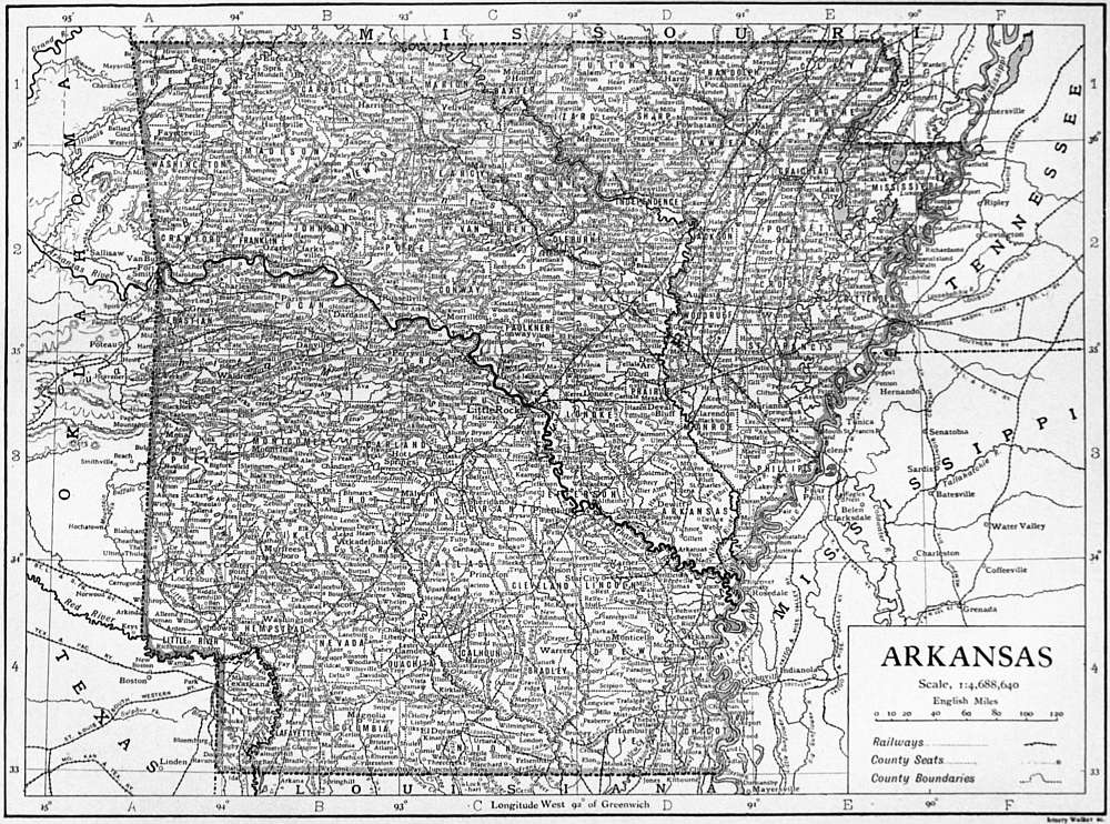
ARKANSAS, one of the South Central states of the United States of America, situated between 89° 40′ N. and 94° 42′ W., bounded N. by Missouri, E. by the Mississippi river, separating it from Tennessee and Mississippi, and W. by Texas and Oklahoma. Its area is 53,335 sq. m., of which 810 are water surface.
Arkansas lies in the drainage basin of the lower Mississippi, and has a remarkable river system. The Arkansas bisects the state from W. to E.; along its valley lie the oldest and largest settlements of the state. Nine other considerable streams drain the state; of these, the Red, the Ouachita, the White and the St Francis are the most important. There are a number of swamps and bayous in the eastern part.
Physical Features.—The surface of Arkansas is the most diversified of that of any state in the central Mississippi valley. It rises, sloping upward toward the N.W., from an average elevation of less than 300 ft. in the south-east to heights of 2000 ft. and more in the north-western quarter. There are four physiographic regions: two of highlands; one of river valley plain separating the two highland areas; while the fourth is a region of hills, lowlands and scanty prairie. The last covers the E. half of the state, and is part of the Gulf or coastal plain province of the United States. If a line be drawn from the point where the Red river cuts the western boundary to where the Black cuts the northern, E. of it is the Gulf plain and W. of it are the highlands (over 500 ft.) and the mineral regions of the state. They are divided by the valley of the Arkansas river into two regions, which are also structurally different. South of the river are the Ouachita Mountains, and north of it are the Boston Mountains. The Ouachita Mountains are characterized by close folding and faulting. Their southern edge is covered with cretaceous deposits, and their eastern edge is covered as well with the tertiary deposits of the Gulf plains. The Arkansas valley is marked by wide and open folding. The Boston Mountains are substantially a continuation of the Ozark dome of Missouri. Their northern border is marked by an escarpment of 500 to 700 ft. in height. The trend is from E. to W. between Batesville and Wagoner, Oklahoma. In structure they are monoclinical, their rocks—sandstones and shales—being laid southward and blending on that side with the Arkansas valley region. The entire region is very much dissected by streams, and the topography is characteristically of a terrace and escarpment type. In the highlands N. of the Arkansas the country is very irregularly broken; S. of the river the hills lie less capriciously in short, high ranges, with low, fertile valleys between them. The Ouachitas extend 200 m., from within Oklahoma (near Atoka) to central Arkansas, near Little Rock. They are characterized by long, low ridges bearing generally W.-E., with wide, flat valleys. Near the western boundary of the state they attain a maximum altitude of 2900 ft. above the sea, and 2000 ft. above the valleys of the Arkansas and Red river; falling in elevation eastward (as westward) to 500-700 ft. at their eastern end. Five peaks rise above 2000 ft. Magazine Mountain, 2833 ft. above the sea-level and 2350 ft. above the surrounding country, is the highest point between the Alleghanies and the Rockies. Altitudes of 2250 ft. are attained in the Boston Mountains, which are the highest portion of the Ozark uplift, and the most picturesque. The streams are vigorous, and in their lower courses flow in deep-cut gorges, 500 to 1000 ft. deep, almost deserving the name of canyons. The main streams are tortuous, and their dendritic tributaries have cut the region into ridges. The mountains do not fill the N.W. quarter of the state, and are separated from a lower, greatly eroded highland region on their N. by a bold escarpment 500 to 1000 ft. in height. Along the upper course of the White river in the Bostons and in the country about Hot Springs in the Ouachitas is found the most beautiful scenery of the highlands; few regions are more beautiful. The valley region embraces the bottom-lands along the Mississippi, and up the Arkansas as far as Pine Bluff, and the cypress swamp country of the St Francis.
Climate.—The climate of the state is “southern,” owing to the influence of the Gulf of Mexico. The mean temperatures for the different seasons are normally about 41.6°, 61.1°, 78.8° and 61.9° F. for winter, spring, summer and autumn respectively. The normal mean precipitations are about 11.7, 14.5, 10.5 and 10.2 in. for the same seasons. The extreme range of the monthly isotherms crossing the state is from about 35° in winter to 81° F. in summer, and the range of annual isotherms from about 54° to 60° F. That is, the variation of mean annual temperatures for different parts of the state is only 6° F. The variation of the mean annual temperature for the entire state is only 4° (from 59° to 63° F.). The variation of precipitation is as great as 30 in. (from 34 to 64 in.) according to locality. There is little snow, no severe winter cold, and no summer drought. Sheltered valleys in the interior produce spring crops three or four weeks earlier than is usual in Kansas. The climate is generally healthy.
Flora.—Arkansas lies in the humid, or Austroriparian, area of the Lower Austral life-zone, except the highlands of the Ozark uplift and Ouachita Mountains, which belong to the humid, or Carolinian, area of the Upper Austral. The state possesses a rich fauna and flora. From an economic standpoint its forests deserve special mention. The forest lands of the state include four-fifths of its area, and three-fourths are actually covered by standing timber. Valuable trees are of great variety: cottonwood, poplar, catalpa, red cedar, sweet-gum, birch-eye, sassafras, persimmon, ash, elm, sycamore, maple, a variety of pines, pecan, locust, dogwood, hickory, various oaks, beech, walnut and cypress are all abundant. There are one hundred and twenty-nine native species of trees. The yellow pine, the white oak and the cypress are the most valuable growths. The northern woods are mainly hard; the yellow pine is most characteristic of the heavy woods of the south central counties; and magnificent cypress abounds in the north-east. Hard woods grow even on the alluvial lands. “The hard-wood forests of the state are hardly surpassed in variety and richness, and contain inestimable bodies of the finest oak, walnut, hickory and ash timber” (U.S. Census, 1870 and 1900). The growth on the alluvial bottoms and the lower uplands in the E. is extraordinarily vigorous. The leading species of the Appalachian woodland maintain their full vigour of growth nearer to the margin of forest growth in this part of the Mississippi valley than in any other part of the United States; and some species, such as the holly, the osage orange and the pecan, attain their fullest growth in Arkansas (Shaler). There are two Federal forest reserves (4968 sq. m.).
Soil.—The soils of Arkansas are of peculiar variety. That of the highlands is mostly but a thin covering, and their larger portion is relatively poorly fitted for agriculture. The uplands are generally fertile. Their poor soils are distinctively sandy, those of the lowlands clayey; but these elements are usually found combined in rich loams characterized by the predominance of one or the other constituent. Finally the alluvial bottoms are of wonderful richness.
Agriculture.—This variety of soils, a considerable range of moderate altitudes and favourable factors of heat and moisture promote a rich diversity in agriculture. Arkansas is predominantly an agricultural state. The farm area of 1860 was only 28.2% of the whole area of the state, that of 1900 (16,636,719 acres) was 49%; and while only a fifth of this farm area was actually improved in 1860, two-fifths were improved in 1900; thus, the part of the state’s area actually cultivated approximately quadrupled in four decades. The value of products in 1900 ($79.6 millions) was 44% of the total farm values ($181.4 millions). The rise in average value of farm lands since 1870 has not been a fifth of the increase of the aggregate value of all farm property.
The Civil War wrought a havoc from which a full recovery was hardly reached before 1890. The economic evolution of the state since Reconstruction has been in the main that common to all the old slave states developing from the plantation system of ante-bellum days, somewhat diversified and complicated by the special features of a young and border community. The farms of Arkansas increased in number 357.8%, in area 73.7% and in total true (as distinguished from tax) valuation about 53.8% between 1860 and 1900; the decade of most extraordinary growth being that of 1870-1880. Thus Arkansas has shared that fall in the average size of farms common to all sections of the Union (save the north central) since 1850, but especially marked since the Civil War in the “Cotton States,” owing to the subdivision of large holdings with the introduction of the tenant system. The rapidity of the movement has not been exceptional in Arkansas, but the size of its average farm, less in 1850 than that of the other cotton states, was in 1900, 93.1 acres (108.8 for white farmers alone, 49.0 for blacks alone), which was even less than that of the North Atlantic states (96.5 acres, the smallest sectional unit of the Union). The percentage of farms worked by owners fell from 69.1% in 1880 to 54.6% in 1900; the difference of the balances or 14.5% indicates the increase of tenant holdings, two-thirds of these being for shares.
It is interesting to compare in this matter the whites and the negroes. In actual numbers the white farmers heavily predominate, whether as owners, tenants for cash or tenants on shares; but if we look at the numbers within each race holding by these respective tenures (65.0, 8.7 and 26.3% respectively for whites; 25.6, 33.7 and 40.7% for negroes, in 1900), we see the lesser independence of the negro farmer. The cotton counties, which are the counties of densest coloured habitancy, exemplify this fact with great clearness. The few negroes in the white counties of the uplands are much better off than those in the cotton lowlands; more than three times as large a part of them owners; the poorer element is segregated in the cotton region. In Arkansas, as elsewhere in the south, negro tenants, like white tenants, are more efficient than owners working their own lands. The black farmer is in bondage to cotton; for him still “Cotton is King.” He gives it four-fifths of his land; while his white rival allows it only a quarter of his, less by half than the area he gives to live-stock, dairying, hay and grains. At Sunnyside, on the west bank of the Mississippi, negro tenant farmers have been practically forced out of business by Italians, who produced in 1899-1904 more than twice as much lint cotton per working hand, and 70% more per acre. The general place of the negro in agriculture is shown also by the fact that more than four-fifths of the farm acreage and farm values of the state are in the hands of the whites. The white farmer gives an outlay in labour and fertilizers on his farm greater by 61.4% than the black, gathers a produce greater by 22.5%, and possesses a farm of a value 53.5% greater (Census, 1900).
Cotton is the leading product. It absorbs about a third of the area under crops, and its returns ($28,000,000 in 1899) are about a half of the value of all crops. A part of the cotton lands of Arkansas are among the richest in the south. Other distinctively southern products (tobacco, &c.) are of no importance in Arkansas. Cereals are given more than twice as much acreage as cotton, but yield only a third as great aggregate returns, Indian corn being much the most remunerative; about three-fourths of the cereal acreage are given to its cultivation, and it ranks after cotton in value of harvest.1 For all the other staple agricultural products of the central states the showing of Arkansas is uniformly good, but not noteworthy. But its rank as a fruitgrowing country is exceptional. Plums, prunes, peaches, pears and grapes are cultivated very generally over the western half of the state (grapes in the east also), but with greatest success in the south-west; apples prosper best in the north-west. Small berries are a very important product. All fruits are of the finest quality. For apples the state makes probably a finer showing than that of any other state except Oregon. About ninety varieties are habitually entered in national competitions. The fruit industry generally has developed with extreme rapidity.
Manufactures.—Although Arkansas is rich in minerals and in forests, in 1900 only 2% of its population were engaged in manufacturing. But the development has been rapid; the value of products multiplied seven times, the wages paid nine, and the capital invested twelve, in the years 1880-1900; and the increase in the same categories from 1900-1905 was 35, 42.8 and 82.4% respectively.2 It must be noted as characteristic of the state that of the total manufactures in 1905, 80.3% were produced in rural districts (83.7 in 1900). About two-thirds of the increase between 1890 and 1900 was in the lumber industry which was of slight importance before the former year; it represented more than half the total value of the manufactures of the state in 1905 (output, 1905, $28,065,171 and of mill products $3,786,772 additional); in the value of lumber and timber products the state ranked sixth among the states of the United States in 1900, and seventh in 1905. After the lumber and timber industry ranked in 1905 the manufacture of cotton-seed oil and cake ($4,939,919) and flour and grist milling. Cotton ginning increased 739% from 1890 to 1900.
(Click to enlarge.)
Minerals.—The progress of coal-mining has been a striking feature of the state’s economy since 1880. The field extends from Oklahoma eastward to central Arkansas, along both sides of the Arkansas river. A production of 5000 tons (short) in 1882 became 542,000 tons in 1891 and 2,229,172 tons in 1903—a maximum for the state up to 1905; in 1907 the yield was 2,670,438 tons, valued at $4,473,693; the value of the product increased more than eight-fold in 1886-1900. The United States Geological Survey estimates that three-fourths of the coal area (over 1700 sq. m.) can made commercially productive. Apart from coal the great and varied mineral wealth of the state has been only slightly utilized. The great zinc and lead area along the northern border in the plateau portion of the Ozark region has proved a disappointment in development; the iron areas have hardly been touched, and the product of the exceptionally promising deposits of manganese lost ground after 1890 before the output of Virginia and Georgia. Among the products of the rich stone quarries of the state, only that of abrasive stones is important in the markets of the Union; the novaculites of Arkansas are among the finest whetstones in the world. Deposits of true chalk are utilized in the manufacture of Portland cement for local markets. The chalk region lies in the S.E. part of the state, S. of the Ouachita Mountains. Bauxite was discovered in the state in 1887, and the product increased from 5045 long tons in 1899 to 50,267 long tons in 1906, the production for the whole country in 1899 being 35,280 long tons and in 1906 75,332 long tons. The only other states in which bauxite was produced during the period were Alabama and Georgia, which in this respect have greatly declined in importance relatively to Arkansas. Extremely valuable and varied marls, kaolins and clays, fuller’s earth, asphaltum and mineral waters show special promise in the state’s industry. In 1906 diamonds were found in a peridotite dike in Pike county 2½ m. S.E. of Murfreesboro; this is the first place in North America where diamonds have been found in situ, and not in glacial deposit or in river gravel.
Communications.—The rivers afford for light craft (of not over 3 ft. draft) about 3000 m. of navigable waters, a river system unequalled in extent by that of any other state. The labours of the United States government have much extended and very greatly improved this navigation, materially lessening also the frequency and havoc of floods along the rich bottom-lands through which the rivers plough a tortuous way in the eastern and southern portions of the state. As a result of these improvements land and timber values have markedly risen, and great impetus has been given to traffic on the rivers, which carry a large part of the cotton, lumber, coal, stone, hay and miscellaneous freights of the state. The greatest of these internal improvements is the St Francis levee, from New Madrid, Missouri, to the mouth of the St Francis, 212 m. along the Mississippi; an area of 3500 sq. m., of exceptional fertility, is here reclaimed at a cost of about $1500 per sq. m. (as compared with $10,000 per sq. m. for the 2500 sq. m. reclaimed by the Nile works at Assuan and Assiut). Whether with regard to area or population, Arkansas is also relatively well supplied with railways (4,472.8 m. at the end of 1907). A state railway commission controls transportation rates, which are also somewhat checked by the competition of river freights. There is also a considerable passenger traffic on the Arkansas.
Population.—The population in 1910 was 1,574,449. The growth in 1880-1900 is shown by the following table:—
Census Year. Total Pop. % White Pop. % Negro Pop. Average per sq. m. % Increase by decades
Total White Negro
1880 802,525 73.7 26.3 15.1 65.6 63.3 72.4
1890 1,128,211 72.6 27.4 21.5 40.6 38.4 46.6
1900 1,311,561 72.0 28.0 25.0 16.3 15.4 18.7
In 1900 the rank of the state in total population was twenty-fifth, and in negro population tenth. The proportion of the coloured element steadily rose from 11% in 1820 to 28% in 1900, at which time there were more than a dozen counties along the border of the Mississippi and lower Arkansas in which the negroes numbered 50 to 89% of the total. They have never been a large element in the highland counties; it was these counties which were most strongly Unionist at the time of the Civil War, and which to-day are the region of diversified industry. About a ninth of the state’s population is gathered into towns of more than 2000 inhabitants. Fort Smith (pop. 11,587 in 1900), Little Rock, the state capital (38,307), and Pine Bluff (11,496) lie in the valley of the Arkansas. In 1900 a dozen other towns had a population exceeding 2500, the most important being Hot Springs (9973), Helena (5550), Texarkana (4914), Jonesboro (4508), Fayetteville (4061), Eureka Springs (3572), Mena (3423) and Paragould (3324). Foreign blood has only very slightly permeated the state; negroes and native whites of native parents make up more than 95% of its population. Immigration is almost entirely from other southern states. The strongest religious sects are the Methodists and Baptists.
Government.—The present constitution of the state dates from 1874 (with amendments). Few features mark it off from the usual type of such documents. The governor holds office for two years; he has the pardoning and veto power, but his veto may be overridden by a simple majority in each house of the whole number elected to that house (a provision unusual among the state constitutions of the Union). There is no lieutenant-governor. The legislature is bicameral, senators holding office for four years, representatives (about thrice as numerous) for two. The length of the regular biennial legislative sessions is limited to sixty days, but by a vote of two-thirds of the members elected to each house the length of any session may be extended. Special sessions may be called by the governor. A majority of the members elected to each of the two houses suffices to propose a constitutional amendment, which the people may then accept by a mere majority of all votes cast at an election for the legislature (an unusually democratic provision); no more than three amendments, however, can be proposed or submitted at the same time. The supreme court has five members, elected by the people for eight years; they are re-eligible. The population of the state entitles it to seven representatives in the national House of Representatives, and to nine votes in the Electoral College (census of 1900). Elections of members of the state legislature and of Congress are not held at the same time—a very unusual provision. Elections are by Australian ballot; the constitution prescribes that no law shall “be enacted whereby the right to vote at any election shall be made to depend upon any previous registration of the elector’s name” (extremely unusual). The qualifications for suffrage include one year’s residence in the state, six months in the county, and one month in the voting district, next before election; idiots, insane persons, convicts, Indians not taxed, minors and women are disqualified; aliens who have declared their intention to become citizens of the United States vote on the same terms as actual citizens. An amendment of 1893 requires the exhibition of a poll-tax receipt by every voter (except those “who make satisfactory proof that they have attained the age of twenty-one years since the time of assessing taxes next preceding” the election). There is nothing in the constitution or laws of Arkansas with any apparent tendency to disfranchise the negroes; there are statutory provisions (1866-1867) against intermarriage of the races and constitutional and statutory (1886-1887) provisions for separate schools, a “Jim Crow” law (1891) requires railways to provide separate cars for negroes, and a law (1893) provides for separate railway waiting-rooms for negroes. Giving or accepting a challenge to a duel bars from office, but this survival of the ante-bellum social life is to-day only reminiscent. Declared atheists are similarly disqualified. There is no constitutional provision for a census. Marriage is pronounced a civil contract. A law for compulsory education was passed in 1909.
Finance.—The constitution makes 1% on the assessed valuation of property a maximum limit of state taxation for ordinary expenses, but by an amendment of 1906 the legislature may levy three mills on the dollar per annum for common schools; and may “authorize school districts to levy by a vote of the qualified electors of such district a tax not to exceed seven mills on the dollar in any year for school purposes.” The state debt in 1874 was $12,108,247, of which about $9,370,000 was incurred after the Civil War for internal improvement schemes. This new debt was practically repudiated in 1875 by a decision of the supreme court, and completely set aside in 1884 by constitutional amendment. Until 1900, when an adjustment of the matter was reached, there was also another disputed debt to the national government, owing to the collapse in 1839 of a so-called Real Estate Bank of Arkansas, in which the state had invested more than $500,000 paid to it by the United States in exchange for Arkansas bonds to be held as an investment for the Smithsonian Institution, on which bonds the state defaulted after 1839. If the unacknowledged debt be included (as it often is; and hence the necessity of reference to it), very few states—and those all western or southern—have a heavier burden per capita. But the acknowledged debt was in 1907 only $1,250,500, and this is not a true debt, being a permanent school fund that is not to be paid off; of this total in 3% bonds, $1,134,500 is held by the common schools and $116,000 by the state university. In net combined state and local debt, Arkansas ranks very low among the states of the Union. The hired labourer suffers from the “truck” system, taking his pay in board and living, in goods, in trade on his employer’s credit at the village store; the independent farmer suffers in his turn from unlimited credit at the same store, where he secures everything on the credit of his future crops; and if he is reduced to borrow money, he secures it by vesting the title to his property temporarily in his creditor. His legal protections under such “title bonds” are much slighter than under mortgages. Homesteads belonging to the head of a family and containing 80 to 160 acres (according to value) if in the country, or a lot of ¼ to one acre (according to value), if in town, village or city, are exempt from liability for debts, excepting liens for purchase money, improvements or taxes. A married man may not sell or mortgage a homestead without his wife’s consent.
Education.—The legal beginnings of a public school system date from 1843; in 1867 the first tax was imposed for its support. Only white children were regarded by the laws before Reconstruction days. There are now separate race schools, with terms of equal length, and offering like facilities; the number of white and coloured teachers employed is approximately in the same proportion to the number of attending children of the respective races; in negro districts two out of three school directors are usually negroes. “The coloured race as a whole go to the schools as regularly and as numerously in proportion as do the whites” (Shinn). Of the current expenses of the common schools about three-fourths is borne by the localities; the state distributes its contribution annually among the counties. There is also a permanent school fund derived wholly from land grants from the national government. The total expenditure for the schools is creditable to the state; but before 1909 hardly half the school population attended; and in general the rural conditions of the state, the shortness of the school terms and the dependence of the schools primarily upon local funds and local supervision, make the schools of inadequate and quite varying excellence. The average expenditure in 1906 for tuition per child enrolled was $4.93, and the average length of the school term was only eighty-one days. In June 1906 there were 1102 school houses in the state valued at $100 or less. In 1905-1906 the Peabody Board gave $2000 to aid rural schools, and in general it has done much for the improvement of country public schools throughout the state. In 1906 an amendment to the state constitution, greatly increasing the tax resources available for educational work, was passed by a large popular vote. The University of Arkansas was opened at Fayetteville in 1872. The law and medical faculties are at Little Rock. A branch normal school, established 1873-1875 at Pine Bluff, provides for coloured students, who enjoy the same opportunities for work, and are accorded the same degrees, as the students at Fayetteville; they are about a fourth as numerous. In 1905-1906 there were 497 students in the college of liberal arts, sciences and engineering, 548 in the preparatory school and 26 in the conservatory of music and arts, all in Fayetteville; 171 in the medical school and 46 in the law school in Little Rock; and 240 in the branch normal college at Pine Bluff. The university and the normal school are supported by the Morrill Fund and by state appropriations. The state still suffered in 1906 from the lack of a separate and special training school for teachers; but in 1907 the legislature voted to establish a state normal school. Of the Morrill Fund (see Morrill, Justin Smith), three-elevenths goes to the normal school. The agricultural experiment station of the university dates from 1887. The financial support of the university has been light, about three-fifths coming from the United States government. Besides the university there are about a score of denominational colleges or academies, of which half-a-dozen are for coloured students. Among the large denominational colleges are Philander Smith College, Little Rock (Methodist Episcopal, 1877); Ouachita College, Arkadelphia (Baptist, 1886); Hendrix College, Conway (Methodist Episcopal, South, 1884); and Arkansas College, Batesville (Presbyterian, 1872). There are few libraries in Arkansas. In this matter her showing has long been among the very poorest in the Union relatively to her population. Daily papers are few in number. The state charitable institutions—insane asylum, deaf-mute and blind institutes—and the penitentiary, are at Little Rock.
Local government is of the ordinary southern county type, without noteworthy variations. Municipal corporations rest upon a general state law, not upon individual charters. The liquor question is left by the state to county (i.e. including “local,” or town) option, and prohibition is the most common county law, the alternative being high-licence.
History.—The first settlement by Europeans in Arkansas was made in 1686 by the French at Arkansas Post (later the residence of the French and Spanish governors, important as a trading post in the earlier days of the American occupation, and the first territorial capital, 1819-1820). In 1720 a grant on the Arkansas was made to John Law. In 1762 the territory passed to Spain, in 1780 back to France, and in 1803 to the United States as a part of the “Louisiana Purchase.” Save in the beginnings of western frontier trade, and in a great mass of litigation left to the courts of later years by the curious and uncertain methods of land delimitation that prevailed among the French and Spanish colonists, the pre-American period of occupation has slight connexions with the later period, and scant historical importance.
From 1804 to 1812 what is now Arkansas was part of the district (and then the territory) of Louisiana, and from 1812 to 1819 of the territory of Missouri. Its earliest county organizations date from this time. It was erected successively into a territory of the first and second class by acts of Congress of the 2nd of March 1819 and the 21st of April 1820. By act of the 15th of June 1836 it was admitted into the Union as a slave state.
There is little of general interest in the history of ante-bellum days. Economic life centred in the slave plantation, and there was remarkable development up to the Civil War. The decade 1819-1829 saw the first newspaper (1819), the beginning of steamboating on Arkansas rivers, and the first weekly mail from the east. Trade was largely confined to the rivers and freighting for Sante Fé and Salt Lake before the war, but the first railway entered the state in 1853. Social life was sluggish in some ways and wild in others. An unhappy propensity to duelling, the origin in Arkansas of the bowie-knife,—from an alleged use of which Arkansas received the nickname, which it has always retained, of the “toothpick state,”—and other backwoods associations gave the state a reputation which to some extent has survived in spite of many years of sober history. The questions of the conduct of territorial affairs do not seem to have been contested systematically on national party lines until about 1825. The government of Arkansas before the Civil War was always in the hands of a few families closely intermarried. From the beginning the state has been unswervingly Democratic, save in the Reconstruction years, though often with heavy Whig or Republican minorities.
In February 1861 the people of Arkansas voted to hold a convention to consider the state of public affairs. The convention assembled on the 4th of March. Secession resolutions were defeated, and it was voted to submit to the people the question whether there should be “co-operation” through the Lincoln government, or “secession.” The plan was endorsed of holding a convention of all the states to settle the slavery question, and delegates were chosen to the proposed Border State Convention that was to meet at Frankfort, Kentucky, on the 27th of May. Then came the fall of Fort Sumter and the proclamation of President Lincoln calling for troops to put down rebellion. The governor of Arkansas curtly refused its quota. A quick surge of ill-feeling, all the bitterer on account of the divided sentiments of the people, chilled loyalty to the Union. The convention reassembled on call of the governor, and on the 6th of May, with a single dissentient voice, passed an ordinance of secession. It then repealed its former vote submitting the question of secession to the people. On the 16th of May Arkansas became one of the Confederate States of America.
In the years of war that followed, a very large proportion of the able-bodied men of the state served in the armies of the Confederacy; several regiments, some of coloured troops, served the Union. Union sentiment was strongest in the north. In 1862-1863 various victories threw more than half the state, mainly the north and east, under the Federal arms. Accordingly, under a proclamation of the president, citizens within the conquered districts were authorized to renew allegiance to the Union, and a special election was ordered for March 1864, to reorganize the state government. But meanwhile, a convention of delegates chosen mainly at polls opened at the army posts, assembled in January 1864, abolished slavery, repudiated secession and the secession war debt, and revised in minor details the constitution of 1836, restricting the suffrage to whites. This new fundamental law was promptly adopted by the people, i.e. by its friends, who alone voted. But the representatives of Arkansas under this constitution were never admitted to Congress.
The Federal and Confederate forces controlled at this time different parts of the state; there was some ebb and flow of military fortune in 1864, and for a short time two rival governments. Chaotic conditions followed the war. The fifteenth legislature (April 1864 to April 1865) ratified the Thirteenth Amendment, and passed laws against “bush-whacking,” a term used in the Civil War for guerilla warfare, especially as carried on by pretended neutrals. Local militia, protecting none who refused to join in the common defence, and all serving “not as soldiers but as farmers mutually pledged to protect each other from the depredations of outlaws who infest the state,” strove to secure such public order as was necessary to the gathering of crops, so as “to prevent the starvation of the citizens” (governor’s circular, 1865). Struggling in these difficulties, the government of the state was upset by the first Reconstruction Act. The governor in these years (1865-1868) was a Republican, the caster of the single Union vote in the convention of 1861; but the sixteenth legislature (1866-1867) was largely Democratic. It undertook to determine the rights of persons of African descent, and regrettable conflicts followed. The first Reconstruction Act having declared that “no legal state government or adequate protection for life or property” existed in the “rebel states,” Arkansas was included in one of the military districts established by Congress. A registration of voters, predominantly whites, was at once carried through, and delegates were chosen for another constitutional convention, which met at Little Rock in January 1868. The secessionist element was voluntarily or perforce excluded. This convention ratified the Fourteenth Amendment, and framed the third constitution of the state, which was adopted by a small majority at a popular election, marred by various irregularities, in March 1868. By its provisions negroes secured full political rights, and all whites who had been excluded from registration for the election of delegates to the convention were now practically stripped of political privileges. The organization of Arkansas being now acceptable to Congress, a bill admitting it to the Union was passed over President Johnson’s veto, and on the 22nd of June 1868 the admission was consummated.
Arkansas now became for several years Republican, and suffered considerably from the rule of the “carpet-baggers.” The debt of the state was increased about $9,375,000 from 1868 to 1874, largely for railroad and levee schemes; much of the money was misappropriated, and in a case involving the payment of railway aid bonds the action of the legislature in pledging the credit of the state was held nugatory by the state supreme court in 1875 on the ground that, contrary to the constitution, the bond issue had never been referred to popular vote. An amendment to the constitution approved by a popular vote in 1884 provided that the General Assembly should “have no power to levy any tax, or make any appropriation, to pay” any of the bonds issued by legislative action in 1868, 1869 and 1871. The current expenses of the state in the years of Reconstruction were also enormously increased. The climax of the Reconstruction period was the so-called Baxter-Brooks war.
Elisha Baxter (1827-1899) was the regular Republican candidate for governor in 1872. He was opposed by a disaffected Republican faction known as “brindletails,” or as they called themselves, “reformers,” led by Joseph Brooks (1821-1877), and supported by the Democrats. Baxter was irregularly elected. The election was contested, and his choice was confirmed by the legislature, the court of last resort in such cases. He soon showed a willingness to rule as a non-partisan, and favoured the re-enfranchisement of white citizens. This would have put the Democrats again in power, and they rallied to Baxter, while the Brooks party now assumed the name of “regulars,” and received the support of the “carpet-bag” and negro elements. After Baxter had been a year in office Brooks received a judgment of ouster against him from a state circuit judge, and got possession of the public buildings (April 1874). The state flew to arms. The legislature called for Federal intervention (May 1874), and Federal troops maintained neutrality while investigations were conducted by a committee sent out by Congress. As a result, President Grant pronounced for Baxter, and the Brooks forces disbanded.
The chief result was another convention. In 1873 the article of the constitution which had disfranchised the whites was repealed, and the Democrats thus regained power. By an overwhelming majority the people now voted for another convention, which (July to October 1874) framed the present constitution. It removed all disfranchisement, and embraced equitable amnesty and exemption features. It also took away all patronage from the governor, reduced his term to two years, forbade him to proclaim martial law or suspend the writ of habeas corpus, and abolished all registration laws: all these provisions being reflections of Reconstruction struggles. The people ratified the new constitution on the 13th of October 1874. After Reconstruction the state again became Democratic, and the main interest of its history has been the progress of economic development.
The following is a list of the territorial and state governors of Arkansas:—
Territorial.
James Miller3 1819-1825
George Izard 1825-1828
John Pope4 1829-1835
William S. Fulton 1835-1836
State.
James S. Conway 1836-1840 Democrat
Archibald Yell5 1840-1844 ”
Thomas S. Drew6 1844-1849 ”
John S. Roane 1849-1852 ”
Elias N. Conway 1852-1860 ”
Henry M. Rector7 1860-1862 ”
Harris Flannigan8 1862-1865 ”
Isaac Murphy9 1864-1868 Republican
C.H. Smith10 1867-1868 ”
Powell Clayton 1868-1871 ”
Ozra A. Hadley11 1871-1873 ”
Elisha Baxter 1873-1874 ”
August H. Garland 1874-1877 Democrat
William R. Miller 1877-1881 ”
Thomas J. Churchill 1881-1883 ”
James H. Berry 1883-1885 ”
Simon P. Hughes 1885-1889 ”
James P. Eagle 1889-1893 ”
William M. Fishback 1893-1895 ”
James P. Clarke 1895-1897 ”
Daniel W. Jones 1897-1901 ”
Jefferson Davis 1901-1907 ”
John S. Little 1907-1908 ”
X.O. Pindall, Acting Gov 1908 ”
George W. Donaghey 1909 ”
Bibliography.—Information regarding the resources, climate, population and industries of Arkansas should be sought in the volumes of the United States Census, United States Department of Agriculture and the United States Geological Survey (for the last two there are various bibliographical guides); consult also the publications of the Arkansas (Agricultural) Experiment Station (at Fayetteville), the reports of the state horticulturist, the biennial reports of the state treasurer, of the auditor, and of the Bureau of Mines, Manufactures and Agriculture (all published at Little Rock).
The constitutional documents may best be consulted in the latest compiled Statutes of the state. See also J.H. Shinn, Education in Arkansas (U.S. Bur. of Education, 1900); W.F. Pope, Early Days in Arkansas (Little Rock, 1895); and F. Hempstead, Pictorial History of Arkansas (St Louis, 1890). Similar to the last in popular character, vast in bulk and loose in method, are a series of Biographical and Pictorial Histories, covering the different sections of the state (1 vol. by J. Hallum, Albany, 1887; four others compiled anonymously, Chicago, 1889-1891). For the Reconstruction period see especially the Poland Report in House Rp. No. 2, 43 Cong. 2 Sess., vol. i. (1874), and John M. Harrell’s The Brooks and Baxter War: A History of the Reconstruction Period in Arkansas (St Louis, Missouri, 1893), which is frankly in favour of Baxter; also a paper by B.S. Johnson in vol. ii. (1908) of the Publications of the Arkansas Historical Association.
1 For 1906 the Yearbook of the U.S. Department of Agriculture reported the following statistics for Arkansas:—Indian corn, 52,802,659 bu., valued at $24,817,207; oats 3,783,706 bu., valued at $1,589,157; wheat, 1,915,250 bu., valued at $1,436,438; rice, 131,440 bu., valued at $111,724; rye, 23,652 bu., valued at $19,631; potatoes, 1,666,960 bu., valued at $1,116,863; hay, 113,491 tons, valued at $1,123,561.
2 The special census of the manufacturing industry for 1905 was concerned only with the establishment conducted under the so-called “factory system”; for purposes of comparison the figures for 1900 have been reduced to the same standard, and this fact should be borne in mind with regard to the percentages of increase given above.
3 During this period Robert Crittenden, the secretary of the territory, was frequently the acting governor.
4 Robert Crittenden was acting governor in 1828-1829.
5 Samuel Adams was acting governor from the 29th of April to the 9th of November 1844.
6 R.C. Byrd was acting governor from the 11th of January to the 19th of April 1849.
7 Thomas Fletcher was acting governor from the 4th to the 15th of November 1862.
8 Confederate governor.
9 Union governor.
10 United States military (sub) governor.
11 Acting governor.
ARKANSAS CITY, a city of Cowley county, Kansas, U.S.A., situated near the S. boundary of the state, in the fork of the Arkansas and Walnut rivers. Pop. (1890) 8347; (1900) 6140, of whom 302 were negroes; (1905) 7634; (1910) 7508. The city is served by the Atchison, Topeka & Santa Fé, the Missouri Pacific, the St Louis & San Francisco, the Midland Valley and the Kansas South-Western railways. To the south is the Chilocco Indian school (in Key county, Oklahoma), established by the U.S. government in 1884. A canal joining the Arkansas and Walnut rivers furnishes good water power. The manufactories include flour mills, packing establishments, a creamery and a paint factory. The city is situated in the midst of a rich agricultural region and is a supply centre for southern Kansas and Oklahoma, with large jobbing interests. The municipality owns and operates the waterworks. Arkansas City, first known as Creswell, was settled in 1870, was chartered as a city under its present name in 1872 and was rechartered in 1880.
ARKLOW, a seaport and market town of Co. Wicklow, Ireland, in the east parliamentary division, 49 m. S. of Dublin, by the Dublin & South-Eastern railway. Pop. (1901) 4944. Sea-fisheries are prosecuted, and there are oyster-beds on the coast, but the produce requires to be freed from a peculiar flavour by the purer waters of the Welsh and English coast before it is fit for food. The produce of the copper and lead mines of the Vale of Avoca is shipped from the port. There are cordite and explosives works, established by Messrs Kynoch of Birmingham, England. In 1882 an act was passed providing for the improvement of the harbour and for the appointment of harbour commissioners. The town hall and the Protestant church (1899) were gifts of the earl of Carysfort, in whose property the town is situated. There are slight ruins of an ancient castle of the Ormondes, demolished in 1649 by Cromwell. On the 9th of June 1798 the Irish insurgents, attacking the town, were defeated by the royal troops near Arklow Bridge, and their leader, Father Michael Murphy, was killed.