Chapter XXI · GEOGRAPHICAL
Reading edition
In the present chapter I shall invite my reader to make good his advantage over the traveller, and to realise, before proceeding further with the journey, the true meaning and wider connection of those natural features which have composed the landscape day by day. At the same time I shall endeavour to trace the limits of north-eastern or Russian Armenia, extending our view for awhile to comprise the whole of Armenia, and again narrowing it to the area of the Russian provinces.
But at the outset we are prompted to examine the conception so vaguely expressed by the metaphors of tableland and frame of mountain ranges which, with slight variations in the figure, have in the foregoing pages so often been employed. The pursuit of this analysis carries us beyond the sphere of our particular survey, compelling us to consider the structure of Asia as a whole.
From the Mediterranean to the Pacific the Asiatic continent is traversed by a zone of elevated country, which, flanked on the north and south by great chains of mountains, breaks off on the west to the Ægean Sea and to the lowlands of China on the east. Extensive areas of land with considerably lesser altitude are outspread on either side of this gigantic system: in the north the plains of Russia and Siberia, in the south the peninsulas of Arabia and India. The mountain chains which confine the zone of elevated country have been reared during different geological periods; yet they are subject to common laws. They are disposed in extensive arcs, of greater or lesser curvature, which are festooned across the continent on either side of the plateau region with a general direction from east to west. The plateau region is in general synclinal or, in other words, of slightly hollow surface, and, in comparison with the flanking ranges, is flat.
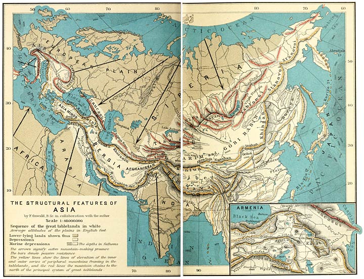
THE STRUCTURAL FEATURES OF ASIA
Engraved and printed by Wagner & Debes, Leipzig.
If we enquire of the geologist the origin of these phenomena, we receive an answer which, while it leaves many points obscure and doubtful, still enables us to trace the operation of fixed principles in the mighty work unfolded before our eyes. Our globe sails through the wan expanse of æther, diffusing the heat with which it is charged. The cooling crust shrinks and gathers inwards towards the centre; but the material of which it consists is inelastic and is thrown into gigantic wrinkles or folds. Radial contraction induces tangential stresses at the surface, colossal forces which bend over and invert the folds, and even thrust the strata one beneath another, causing them to be disposed like the tiles upon a roof. This lateral tension finds most relief where the crust is weakest; and it is at such points, or along such zones, that the process of mountain-making has been developed on the largest scale. It is the tendency of such folded ranges to form arcs of large curvature, which are drawn inwards, where the lateral pressure meets with most resistance, and expand outwards, where it is withstood in a lesser degree.
In Asia the operation of this process of mountain-making has been accompanied by, or has produced, the elevation in mass of large portions of the earth’s crust. The intensely folded regions, or, in other words, the great chains of mountains, are found along the inner and the outer margins of the elevated mass. Between these zones the stratified rocks have no doubt been subjected to the folding process; yet they have escaped the immense contortions that have taken place on either side.
Throughout the continent the lateral force which has been most operative in mountain-making has proceeded from the north. The fact may perhaps be explained by supposing that this force is the result of the active pressure exerted by the hard, unyielding material of which the steppes of Siberia and the basin of the Arctic Ocean are composed. The great arcs which are described by the mountain ranges are in general convex to the south. Thus in western Asia the chains on the inner and outer margins of the elevated area are disposed in two roughly parallel series of arcs bulging towards the south. Of these series the inner arcs have less curvature than the outer, to which they are roughly parallel.
The inner series may be traced with greatest singleness of feature on the west of Hindu Kush—that natural centre of the mountain systems of Asia which at once supplies the most convenient standpoint for a general survey of the structure of the continent, and is placed at the junction of the two great divisions, western and eastern, into which geographers have partitioned this vast area. The Hindu Kush inclines over into the Paropamisus; and the southern portion of the latter range is continued, on the north of Persia, by the mountains of Khorasan. A sharp bend in the belt, just east of the Caspian, turns southwards into the Elburz range, and the beautiful curve of the chain along the margin of the shore may be admired from the waters of that inland sea. The line of Elburz is protracted across the depression of the Araxes valley into the peaks of Karabagh; while the Karabagh system unites with the bold and lofty ridges which in full face of their gigantic neighbour, the Caucasus, overtower the right bank of the Kur. These ridges again connect with the chain we have ourselves crossed between Kutais and Akhaltsykh—a chain which joins the mountains on the southern shore of the Black Sea. The Pontic range forms a bow of wide span and gentle curvature, ending in the hump of Anatolia, where it meets the arc of the Bithynian border hills.
It can scarcely fail to impress the most casual of observers that this double series of arcs, from Hindu Kush to Mediterranean, meet or almost meet at three distinctly traceable and widely separated points. Such approximations occur in Hindu Kush, in Armenia, and in the mountainous districts which border the Ionian seaboard. We can scarcely doubt that they are due to the incidence of a strong opposing force, moving from the south and causing the arcs to be constricted, the ranges to be piled up one behind another, and mountain development to assume its grandest forms. It is probable that the resisting pressure has been furnished in the first two cases by the Indian and Arabian peninsulas. Another feature, less obvious but not less noteworthy, is furnished by the fact that in Armenia and Asia Minor the arcs have been fractured in the process of bending over at or near the points where the approximations between the two series have taken place. The closer the constriction, the sharper, of course, becomes the curve, and the greater the tendency to split. In Asia Minor the union of the series has resulted in complete fracture; the folded area sinks beneath the waters of the Ægean to be represented by the islands which stud the Archipelago, and, further west, by the mountains of the Dalmatian coast.
On the east of Hindu Kush we are as yet in want of sufficient material for so convincing an analysis as the researches of geologists have rendered possible on the west. We know that in eastern Asia a vast area of elevated land is bounded both along the inner and the outer margins by mountain systems of wide extension and great height. Such are the systems of Altai and Tian-shan upon the north, and the mighty bow of the Himalayas on the south. Probably the Kuenlun range carries over the inner series of western Asia, extending eastwards from the Pamirs and serving as a buttress to the immensely elevated plateau of Tibet. If this view be correct, then the Tian-shan and Altai systems may perhaps be regarded as minor earth-waves, following close upon the heels of the Kuenlun, and supporting the highlands of the Tarim basin and the desert of Gobi, the Han-hai or Dry Sea of the Chinese. The plain reader may be content to observe the echelon of mountain ranges which extends from Hindu Kush towards Behring Sea; to note the constant curvature of the arcs towards the south, until, in the Altai group, the eastern arms of the bows are protracted ever further towards the north; to contrast the low-lying plains along the western ends of the echelon with the lofty highlands of Mongolia on the east. The necks of the valleys issue upon the depression of Siberia and the low country through which the Oxus and Jaxartes flow.
But, if Armenia be closely linked with her neighbours on the west and east, she is divided by some of the most effective of natural barriers and natural distinctions from the countries which lie to the north and south. The zones of mountains which on the one side separate her from the coast of the Black Sea and the Georgian depression, and on the other from the lowlands of Mesopotamia, possess in an equal degree the rugged character due to intense folding and are both of considerable width. Sharp ridges with serrated outlines rising one behind another, narrow valleys in which the shadows lie, hissing rivers and bush-grown rocks, grassy uplands or stretches of forest determine the scenery both of the northern and of the southern zone. The alpine region has a breadth of some fifty miles more or less in the direction of the Black Sea, while the corresponding zone, facing the lowlands about Diarbekr, extends, on the whole, over a smaller span. Both zones are practically unlimited in length. They have been factors of paramount influence in the history of the peoples, not only screening the territories they confine from those which lie outside, but also investing them with distinct climatic conditions. For these parallel belts of peripheral mountains do in fact perform the function of supports or buttresses to a series of elevated plains; the valleys in the alpine region are but the succession of terraces which rise to the margin of a lofty platform. A difference in level of several thousands of feet is productive of marked features in the habits and character of the inhabitants; while the alps themselves must necessarily determine the mode of life of the dwellers within them, constraining them to follow the vocation of shepherds rather than that of agriculturists. Thus along the section between Diarbekr and the Armenian highlands three strongly-contrasted types of people will be met. The nomad Arabs or Arabic-speaking cultivators of the lowlands are succeeded by the pastoral Kurds with their tribal organisation, and these again by the Armenian tillers of the soil.
I have already indicated the intimate connection of these peripheral mountains with the structural system of the Asiatic continent. The northerly belt belongs to the inner series of arcs, and that on the south to the outer series. The compression of these arcs—a phenomenon which has engaged our attention—has been effected in the greatest degree within the section of country between Diarbekr and Trebizond. You see the two opposite arcs, one bent to the south and the other to the north, endeavouring to meet under the stress of contending pressures; while on either side of the section the curves diminish in intensity and the spines of the ranges have been allowed to expand like the spokes of a wheel. The northern boundary of Armenia is constituted by the mountains of the northern peripheral region, which enter the country on the west in the Gumbet Dagh. The line may be followed on the map on the north of Shabin Karahisar through the Giaour Dagh and the Kuseh Dagh to the pass over the Vavuk Dagh, lying to the north-west of the town of Baiburt. From the Vavuk pass the spine of the chain confines the valley of the Chorokh by a well-defined and regular parapet; until just east of the town of Ispir it commences to lose this singleness of feature, and to favour a tendency towards bifurcation and branching out. The ridges stretch across the valley in an east-north-easterly direction, the direction which the spine has so long pursued; and their course may be traced through the mountainous country on the north of Olti until they become buried beneath the volcanic accumulations of the plateau country in the districts of Göleh and Ardahan. It is most interesting to trace their probable emergence from this canopy on the further side of the tableland, and to recognise in the elevations of Shishtapa (north of Alexandropol) and of Madatapa ridges that have survived the splitting and fracture of the Pontic chain. But this is a feature of greater interest to the geologist than to the geographer; and the latter will follow the Black Sea range through the heights of the Khachkar and Parkhal mountains to the Kukurt Dagh on the west of Artvin. The ridge which stretches thence in a north-north-easterly direction towards the seaboard, giving passage to the Chorokh and determining the Russian frontier, has been deflected by the mass of the Karchkhal mountains, the radial system to the north-east of Artvin. It crosses the river close to the coast behind Batum, and may be traced through the peaks of Taginaura, Gotimeria and Nepiszkaro along the plains of Imeritia to the passage of the Kur through the gorge of Borjom. These last-named peaks belong to the Akhaltsykh-Imeritian border range, which my reader has crossed with me by the pass of Zikar, and of which the direction is almost due east and west.
It is impossible to delimit the northern frontier of Armenia by a slavish insistence upon the boundary of the Black Sea range. That system is the natural boundary for a distance of very many miles, as it extends along the course first of the Kelkid Su, the ancient Lycus, and then along that of the Chorokh. But the fracture of the arc which has taken place in the country watered by the uppermost branches of the Kur and Arpa Chai, and the eating back of the more easterly affluents of the Chorokh, which have carved out the intricate country in the neighbourhood of Olti, have resulted in the interruption of the normal sequence until it is again resumed in the Akhaltsykh-Imeritian range. It is consonant with the natural conditions to take the frontier across the valley of the Chorokh in the vicinity of Ispir, and to lead it by the heights which contain the sources of the Chorokh and the Serchemeh Chai to the Dümlü Dagh, the parent mountain of the Western Euphrates. It will then follow, first in an easterly and then in a north-easterly direction, the elevated water-parting between the basins of the Araxes and the Black Sea; and, after effecting a union through the Chamar Dagh with the volcanoes of the Soghanlu Dagh, will be protracted along the meridional and volcanic elevation which confines the highlands of Göleh and Ardahan on the west. The junction of these vaulted heights with the Akhaltsykh-Imeritian range may be traced through the ridge of the Sakulaperdi Dagh to the peak of Gotimeria. All the rivers on the northern slopes of this section of the Armenian frontier drain into the Black Sea.
The passes across this zone are of considerable elevation, though a good number are open all the year round. I have been unable to ascertain the height of the pass over the Gumbet Dagh between Karahisar and Kerasun. But the valleys of the Upper Kelkid and the Upper Chorokh may be reached from Trebizond without encountering a greater altitude than something less than 7000 feet. To this figure must be added another 600 to 1000 feet before the traveller will have crossed the block of elevated tableland interposed between those valleys and the great Armenian cities, Erzinjan and Erzerum. East of Baiburt the spine of the Pontic range becomes more lofty: and the track which leads from Rizeh to Ispir in the Chorokh valley surmounts it at a height which has been estimated at 9000 feet above the sea. Where the frontier has become coterminous with the northern border heights of Erzerum and Pasin the roads are taken by passes of over 7000 feet (Erzerum-Bar-Olti) and 8500 feet (Hasan Kala-Olti) into the basin of the Black Sea; while during its protraction northwards through the Soghanlu Dagh to the Sakulaperdi Dagh it may be traversed by well-beaten paths or tolerable roads at elevations which range between 6085 feet (Eshak-Meidan Pass) and about 7000 feet. The principal avenues of communication across the mountainous region are those of Erzinjan-Gümüshkhaneh, Baiburt-Gümüshkhaneh, Erzerum-Olti, Kars-Olti, Ardahan-Olti and Ardahan-Ardanuch. A road has been constructed from Kutais to Abastuman, and is gaining traffic every year.
Copious rainfall and abundant vegetation are characteristic of the northern peripheral mountains. In some of the valleys the clouds settle for several months in the year, seldom lifting to disclose a view of the sun. It may often happen that during several weeks or even months crests and depressions alike will be shrouded in mist. In summer there is produced the likeness of a succession of forcing houses, the slopes and hollows being covered with a bewildering tangle of trees and creepers and scarcely passable undergrowth. From the branches are festooned the lichens, grey-white streamers like human hair; the crimson stools of a fungus shine out from the gloomy brakes, and the pointed pink petals of the Kolchian crocus clothe each respite of open ground. Such conditions are most prevalent in the narrow valleys near the Pontic coast, while the slopes which face the Rion and the opposite Caucasus are distinguished by magnificent forests. Several peoples, distributed over fairly distinct zones, inhabit these fastnesses. On the west we have the Greeks, inclined to commerce and close to a seaboard; they may be found struggling upwards to the spine of the range and even in a sporadic manner upon its southern slopes. Further east dwell the Lazis, a wild people; and their neighbours, the Ajars, in the mountains behind Batum. These are succeeded by a population of Georgian shepherds and small cultivators, whose picturesque chalets are surrounded with Indian corn.
It remains to follow the extension of the mountains of the northern border during their progress eastwards from the Borjom gorge. The comparative narrowness of the belt in the neighbourhood of that great cleft is explained by the fracture of the arc to the south of this region and the covering up of its more southerly members by volcanic emissions. But this decrease in width is to some extent balanced by the propinquity of the Caucasus. It is in this neighbourhood that the single link connecting the belt with Caucasus stretches across the Georgian depression, dividing the Rion from the Kur; it may be known as the Meschic linking chain. East of this barrier the vegetation diminishes in luxuriance. The Akhaltsykh-Imeritian range is continued beyond the gorge by the latitudinal Trialethian chain—a system of which the backbone is formed by the Arjevan ridge, and which is bounded on three sides by the course of the Kur. A branch of this system is seen to continue the direction of the Pontic range, inclining off at a sharp angle from the principal elevation to form the valley of the Gujaretis. It culminates in the peaks of the Sanislo group at an extreme height of 9350 feet, and sinks beneath the lavas of the plateau region. The Trialethian mountains have undergone a process of uptilt, which has caused them to fall away abruptly towards the north and to form terraces of plateau-like character on the south.
We have now pursued the northern border of the Armenian highlands from the coast of the Black Sea to that of the Caspian, where the belt passes over into the mountains framing Persia upon the north to be protracted into the Hindu Kush. The corresponding southern zone is much more simple of feature; but it lies outside the province of the present chapter, being included, throughout its entire extension along these highlands, within Turkish territory. Between the northern and southern zones of peripheral mountains several distinct but minor members of the orographical system we have been examining furrow the surface of the tableland. These will receive their proper attention in the companion chapter of the second volume, situated as they are for the most part beyond the limits of our present survey. But one of them may be traced to the commanding elevation which determines the valley of the Araxes during its passage through Chaldiran to the confluence of the Arpa Chai; and it is this range—for it deserves to be described as a range—that not only constitutes the present frontier between the Russian and Turkish Empires, but in fact divides the area of Armenia into two parts. You must either cross the spine of this chain, which describes a symmetrical curve, or follow along the plains at its northern or southern flanks, should you desire to pass from the plateau region on the north and east to the corresponding districts on the south and west. In the preceding chapter we have become familiar with some of its interesting features; and we have been introduced to it under the general name of the Ararat system or Aghri Dagh. Shatin Dagh is another name under which its westerly portion is designated by some writers, and which is scarcely less well qualified to express its ruggedness. This range carries the natural frontier between the two divisions from the Kuseh Dagh (11,262 feet) in the west to Little Ararat (12,840 feet) in the east.
It will thus be seen that the present area of Russian Armenia corresponds in a remarkable manner with the limits assigned by Nature to the more north-easterly of the two extensive regions into which she has parcelled Armenian soil. The Russian frontier is drawn from the coast of the Black Sea along the water-parting of the tributaries to the western bank of the Lower Chorokh through the peripheral region, and west of the town of Olti, to the Armenian border at the Chakhar Dagh. Thence it is taken across the Araxes to the spine of the Aghri or Shatin Dagh just north-west of the dome of Kuseh Dagh. It follows the spine of the range to the neighbourhood of Great Ararat, whose hallowed summit it embraces within the dominions of the Tsar. From the crest of the Little Ararat, whose south-eastern slopes are left to Persia, it reaches across the plain to the right bank of the Araxes a little below the famous monastery of Khor Virap. The Araxes forms the boundary between the Russian and Persian Empires from this point to near its confluence with the Kur.
My reader has journeyed with me from the Zikar Pass to Akhaltsykh and Akhalkalaki; from the cañon of the Toporovan river and the basin of the Kur to the streams which constitute the most northerly sources of the Araxes. We have crossed the country from Alexandropol to Erivan, from Erivan to Kars, from Kars to Kagyzman. What an impressive unity underlies the pleasing diversity of the landscapes, which melt into one another as you pass! The partings of the waters are formed by slopes which you perceive with difficulty, so gradual has been the rise and the decline. The territories of Akhaltsykh, Akhalkalaki, Alexandropol, Kars and Ardahan are all bound up together in the distribution of the space, and share features in common to a much greater extent than they are distinguished by local idiosyncrasies. The mountains, of which the outlines are never absent from the landscape—soft, long-drawn, convex shapes—stand on the floor of the tableland, like pieces upon a chessboard, which one may move from square to square. Such are the radial mass of Dochus Punar near Akhaltsykh (over 9500 feet), the two considerable elevations which enclose Lake Chaldir (Akhbaba Dagh, 9973 feet; Kisir Dagh, 10,472 feet), and even the colossal Alagöz (13,436 feet). All are due to volcanic action, quite recent in geological time; and a similar origin belongs to the minor shapes which stud the country like bubbles upon a cooling body. Mountains of this character perform the function of boundary columns between the various districts, great and small. They determine but do not separate. How different in form and function from the folded ridges of the peripheral region, among which a single example of such recent volcanic fabrics could seldom be observed.
If we desire for convenience to partition the plateau region which is Russian Armenia, it falls most naturally into two spheres. The one will comprise a rectangular area, of which the limits on the west and east are the meridional volcanic water-partings from the Soghanlu Dagh to the heights of Sakulaperdi on one side and from the Karakach Dagh to Tawkoteli on the other. The southern boundary of this area will be the cañon of the Araxes from its entrance into Russian territory to below the confluence of the Arpa Chai. Towards the north it includes the districts as far as the Sanislo extension of the Trialethian mountains and the Akhaltsykh-Imeritian border chain. The vast circumference of Alagöz is placed on its south-eastern confines, sending out long feelers towards the left bank of the Arpa Chai, pushing back the mountains of the eastern border and, as it were, propping up the highlands on the north-west. This volcano may be said to lead over to the second sphere, which is for a great part an area of considerable depression, and, as compared with the longitudinal axis and symmetrical shape of its companion, is of irregular form with the greatest length from north-west to south-east. These two spheres are distinguished by features which are sufficiently contrasted to suggest a double image to the mind.
I. I have invited attention to the characteristics which Armenia shares in common with her neighbours in the series of the Asiatic tablelands, Persia on the east and Asia Minor on the west. In the brief survey to which I proceed of the plateau region within the Russian frontier it is necessary at the outset to remark upon some of the idiosyncrasies which distinguish Armenia as a whole from the other members of the series. There is in the first place the far greater elevation, investing her territory with the attributes of a roof to the adjacent countries, from which the waters gather to be precipitated in different directions, and to find their way not only to the Black Sea and the Caspian but also by almost endless stages to the Persian Gulf. The prominent part which has been played by recent volcanic action is another and not less impressive phenomenon. Which of her neighbours could compete with her in this respect? Where could one meet with an Ararat, a Sipan and a Nimrud, to say nothing of an Alagöz and a Bingöl? Both these manifestations are exemplified in a striking manner by the surface features of the rectangular area of the more northerly sphere.
The higher levels of this region are situated at an altitude of some 7000 feet above the sea. I am speaking not of the mountains but of the plains. The uplands which give rise to the Kur in the district of Göleh must come very near to this level. The parting of the waters of the Kur and Araxes near the village of Shishtapa, in an open landscape which may be compared to rolling downs, lies at about 7000 feet. Lake Chaldir has an elevation of 6522 feet; while of the smaller sheets of water Lake Toporovan, with 6876 feet, and the Arpa Göl, with 6706 feet, slightly better this already considerable figure. Where the plateau falls away to the abysmal cañon of the Araxes its edge is nearly 6500 feet high. The town of Ardahan stands at a level of 5840 feet and Kars of 5700 feet. Alexandropol, the principal city, occupies the hollow of a vast basin-like plain; yet it is over 5000 feet above the sea. These elevations are much greater than the average even in Persia, though they are to a certain extent maintained in the frontier province of Azerbaijan and along the edge of the southern peripheral mountains (Tabriz, 4650 feet; but Tehran, 3800 feet; Ispahan, 5070 feet).
The distribution of such shapes due to volcanic agency may often appear arbitrary to an unpractised traveller. Here a group of stately forms resembling the giants of a forest, there a number of insignificant eminences representing the small fry. All will be found to be subject to definite and ascertainable principles, the nature of which becomes clearer at each step forward of scientific research. Perhaps the most interesting principle which we see operative in this region is the outcrop of volcanoes along meridional lines. Such groups pursue a course at right angles to the strike of the rocks within the area of the peripheral mountains. In this connection we may recall the fact that the plateau region with which we are dealing occupies the apex of the bend over of the inner arc. Lines of fracture have been thrown out at right angles to the folding, and eruptive agency has fastened upon these weakened zones of the earth’s crust. Not only may these lines be traced on the west and east of the plateau, of which, indeed, they have largely determined the shape, but also well inside of the marginal districts. In the west we have the Soghanlu group stretching north to Allah Akbar (10,218 feet), whence the direction is continued through the Ueurli Dagh (9055 feet) and the Arzian Dagh to the Chibukh-Naryn-Bashi Dagh. There the volcanic water-parting effects a junction with the Akhaltsykh-Imeritian chain in the ridge of the Sakulaperdi Dagh. In the east we have already followed the row of marginal volcanoes from Tawkoteli to Karakach. Inside these series we recognise this same north-south direction in the Abul-Samsar system, in the mountains on either side of Lake Chaldir, and, lastly, in the connection which we can scarcely err in assuming between the Kisir Dagh, overlooking the westerly shore of this lake, and its neighbour on the north, the Dochus Punar.
Compared with Alagöz and Ararat even the absolute height of these mountains may be termed insignificant. The lofty level of the plains from which their slopes gather robs them of several thousand feet. Great Abul, with an altitude of nearly 11,000 feet, rises from a plain which itself lies at an elevation of 5500 feet. The dome-shaped vaultings of the Soghanlu Dagh near some of the sources of the Kars river are almost entirely shorn of their considerable stature by the height of the adjacent downs. In such surroundings the mountains appear to the eye as little more than hills.
The rivers as a rule flow in deep cañons which they have eroded in the volcanic soil. Their head waters meander over grassy downs. Temperately they thread their way over the uplands or in the cañons, except where blocks of lava may have tumbled into the trough, causing the stream to wreathe and hiss. You pass from district to district either along such natural avenues, with the towering cliffs, for the most part bare, on either hand; or, emerging from the weird scene within the hollow, over the surface of almost limitless plains. Not a tree in the landscape, and only patches of fallow and stubble, without a boundary, with rarely a village discernible from afar.
From time to time you may obtain a glimpse of the peripheral mountains—serrated summits, bush-grown slopes. These contrast to the soft convexities of the forms about you and the vaultings of the volcanic eminences. The surface of the friable soil is devoid of wood and almost of vegetation; and the volcanic matter of which it is composed produces tints of pink and ochre upon which the shadows lie transparent and thin. The rarefied atmosphere of these high regions braces the faculties and sharpens the senses; and whatever clouds may have climbed the barrier of the peripheral ranges are suspended high in the heaven, seldom obscuring the brilliant sun. During winter the land is covered with snow.
Other effects of the violent disturbance to which the region has been subjected are manifest on a large scale. Thus all the way from the Soghanlu Dagh on the south to the neighbourhood of the mountains of the Ajars on the north the ground has fallen away to the labyrinth of valleys which feed the Chorokh by what geologists would call an extensive fault. The edge of the plateau region stands up boldly upon that side from the levels adjacent on the west. A still more recent earth movement may be represented by the uptilt towards the north-east of a considerable block of country lying between Kars and the junction of the Arpa with the Araxes. This phenomenon, which recalls a similar occurrence in the Trialethian district, has occasioned the curious course of the stream of Kars, which, rising in close vicinity to the flood of the same river to which ultimately it becomes tributary, pursues a course almost at right angles to that of the Araxes for a distance of thirty miles. To the same cause is in part due the extraordinary elevation of the levels along the left bank of the Araxes between Armutli and the confluence of the Arpa Chai.
II. A traveller coming from Alexandropol down the stream of the Arpa or along the valley of the Abaran, further east, can scarcely fail to become sensible of an appreciable change in climate and scenery by the time he shall have rounded the colossal pile of Alagöz. It is not, indeed, a new country or a new clime. The shapes which rise on the skyline are due to the same volcanic agency which has imprinted its character upon the northern landscapes. The shelving away of the ground to the basin-like depression which receives the Araxes recalls similar surface features in the northern districts. The rays of the sun fall from a heaven which remains blue. Clouds are still floating upon the azure, or are suspended upon the higher outlines. What has changed is the scale and intensity of the phenomena. The hills have given place to great mountains, the down-like expanses to one vast area of sloping ground. Into those dreamy spaces sweep the forms of the landscape, circled round them for a visible distance of some sixty miles.
The valley of the Araxes from the neighbourhood of Sardarabad to that of Julfa—a space of over a hundred miles—composes nearly one-half of the more southerly sphere of north-eastern Armenia. We are already so familiar with its overpowering individuality that it would be turning finished ground to describe it anew. For many a mile it is only confined at an immense interval by the fabric of Ararat and the pile of Alagöz. But, even when the river—a ribbon in the expanse—has already distanced the Little Ararat, the folds of the landscape are ample into which it descends. Volcanoes on such a huge scale as these two Armenian giants could scarcely be expected to rise save on the margins of a great depression, whether subsidence may have been the cause or the effect. To the 7000 feet of the plateau region on the north this basin-like plain opposes a maximum elevation of 3000 feet and a minimum of something over 2000 feet.
The area of the country comprised within the two spheres of which I have been speaking is about 20,587 square miles. With the exception of a narrow strip on the right bank of the Araxes, measuring 1518 square miles, the entire territory—more than commensurate with that of Servia—lies within the dominions of the Tsar.