Part 2 — CHAPTER XII REGIONAL GEOGRAPHY
Reading edition
We shall not attempt the thankless and impossible task of giving a complete conspectus of Western regional lore in the twelfth and early thirteenth centuries. This chapter, like its predecessors, consists largely of illustrative examples.
GENERAL CHARACTER OF REGIONAL KNOWLEDGE OF THE PERIOD
Geography of Tradition and Geography of Observation
We explained in the Introduction that there were two kinds of geographical information available in the Middle Ages—information derived from earlier literature and information derived from contemporary tradition and observation. In the period we are studying, these were found among men of very different interests and activities, and hence they usually failed to blend. It is true that now and then in a work of erudition of the time we come across a report of some original observation made by the writer himself or learned by him from a contemporary; but these data were seldom really assimilated into the body of the text, seldom used as a check on the assertions of older authorities. They seem to float like drops of oil on the deep, or shallow, waters of authoritative learning. Conversely, in works recording contemporary events—histories, chronicles, letters—we often come across facts and theories that were taken from older books; but these were infrequently subjected to critical examination in the light of contemporary knowledge. On the contrary, they were usually treated with indulgence or respect merely because they were old, even when observed phenomena seemed to prove them false.
In the present as in the foregoing parts of this book the attempt is made to distinguish between these two distinct types of geographical lore. For many regions the geographical ideas are 256indicated that were derived from Pliny, Solinus, Isidore, Bede, and other encyclopedists and that found expression in treatises like the De imagine mundi, the Otia imperialia, and the Image du monde. In contrast to these there is set forth the kind of information that was being gathered by contemporary eyewitnesses.
Gradations of Accuracy of Knowledge
Maps are sometimes drawn at the present day to show the state of progress of geographical knowledge. Upon these by various tints or shadings are indicated tracts that are accurately surveyed, partially surveyed, known only through route traverses, known only through reports from natives, or totally unknown. No such map could be constructed to show the character of regional knowledge in the Middle Ages, because our sources of information are not sufficiently complete and because the knowledge both actually and potentially available varied from country to country, from community to community, even from individual to individual. The printing press and facility of communication between the peoples of the world has rendered scientific knowledge or, at any rate, the possibility of obtaining scientific knowledge the common property of all modern civilizations. An Australian student, for instance, if he is willing to take the time and trouble, can learn through research virtually all that is known to Danish or Icelandic scholars about the geography of Greenland. In the Middle Ages, on the contrary, we may feel certain that the Danes and Norwegians had at hand much detailed information on Greenland and the Arctic shores of Europe that the Italian had no means whatever of obtaining. Correspondingly, the Italian trader of Genoa or Venice unquestionably knew a great deal about remote parts of Asia and North Africa that could never reach the ears of an author of a De imagine mundi or of a Lambert of St. Omer, writing in quiet cloisters of France or Belgium.
Yet if, for these reasons, we cannot show on a map the gradations in the character and accuracy of Western geographical knowledge in the age of the Crusades, such gradations nevertheless existed. From the point of view of Western Europe as a 257whole they might be grouped in a broad way as follows. First there were the well-known regions about which knowledge was derived and kept fresh through active commercial, diplomatic, ecclesiastical, military, and scholarly enterprise. These regions may be said to have included most of Europe west of the Elbe and Hungary. They also included the overland routes to Constantinople, the shores of the Mediterranean, and the Holy Land. From the point of view of the Scandinavian peoples, who were great travelers, they took in not only the foregoing regions but also the Baltic coasts, southern Norway and Sweden, and Iceland. Beyond the bounds of the well-known areas lay a second group of areas about which a fair amount of reasonably trustworthy information was at hand, derived from one of three sources: (1) reports of occasional travelers; (2) more or less reliable hearsay; (3) classical descriptions drawn from literary sources. Much of Western Asia and North Africa fell within this category and, for the Scandinavians, Greenland. Beyond lay the third group of regions known only through the vaguest of rumors—the domains of fabulous monsters and legendary men. To some writers India was such a land, to others Russia and northern Scandinavia, to still others the legendary isles that lay concealed in the Western Ocean. Finally, beyond them came those regions lying without the known world, about which the men of the Middle Ages themselves would have acknowledged that they knew nothing: the austral continent, the countries of the antipodeans, antoikoi, antichthones, which have been discussed in an earlier chapter. No boundaries could be drawn setting off these various tracts from one another; the well-known shaded off imperceptibly into the less well-known, and the vaguely known merged into fairyland; within each well-known tract were islands of doubt and mystery, and fabulous stories were told of even the most commonplace features of the landscape.
THE “OIKOUMENE” AS A WHOLE
Before turning to the various regions of the known world—the oikoumene, as the Greeks called it; the orbis terrarum or habitatio of the Romans—something must be said concerning theories 258about the oikoumene as a whole, about its center, and about Paradise and the four rivers of Paradise. It was usually supposed that the oikoumene itself occupies a relatively restricted part of the surface of the globe. The words of Seneca to the effect that there is only a short distance from Spain to India imply that the known world must stretch out over much more than a half of the circumference of the sphere.[1175] Though these words were often read in our period, scant attention was paid either to them or to the Arabic interpretation of Aristotle’s similar theory until a later date. Roger Bacon’s specific explanation that the habitatio extends around much more than half the earth’s circumference represents an opinion that was exceptional.[1176] The majority of the thinkers of the twelfth and early thirteenth centuries who speculated on the subject at all were probably under the spell of the theory fostered by Macrobius, which made our habitable portion of the earth one of four similar regions separated from each other by two oceans.[1177] This undoubtedly was the view most widely accepted, but in addition the idea was perhaps already being propounded early in the twelfth century that the lands of the known world form merely a small portion of the surface of the terrestrial sphere emerging above the surface of a larger, enveloping sphere of water.[1178]
The “Oikoumene” Divided into Three Parts
The writers of the Crusading age were unanimous in dividing the oikoumene itself into three parts, Asia, Libya (or Africa), and Europe. Bernard Sylvester said: “In two parts the ether, and likewise in two parts the air, but in three parts you are to understand that the land is divided,”[1179] almost as if a tripartite division of the lands were in accord with a law of nature. This division was inevitable in view of what was known of the arrangement of lands and seas. Orosius,[1180] however, had spoken of certain writers who would split the known world in two, making Africa a part of Europe “because of its small size” and making Asia as large as Africa and Europe together. Those who had preferred to conceive of Africa as a separate continent, he had said, did so not on account of its size but because it is cut off from Europe by an 259arm of the sea. These words of Orosius were quoted by Otto of Freising[1181] and by Gervase of Tilbury.[1182] The theory that Asia is equal in size to Europe and Africa put together is reproduced by the author of the De situ terrarum,[1183] and upon it was based that symmetrical division of the world’s surface which we find depicted on the so-called T-O maps of the early Middle Ages.[1184]
Isidore of Seville drew largely from Orosius in writing his chapters on geography. Theoretically he accepted the tripartite division,[1185] but in his actual treatment of the countries of the world he appended a discussion of islands to his discussion of the continents. In this he was followed by the author of the De imagine mundi and by many other writers of the time,[1186] all of whom declared that the earth’s surface is divided in three, but added chapters on the islands after their descriptions of Asia, Africa, and Europe.
THE CENTER OF THE “OIKOUMENE”
Jerusalem as the Center
During the Middle Ages the idea that Jerusalem is at the center of the oikoumene seems gradually to have gained ground. Arculf, a bishop of an unknown see in Gaul and pilgrim to the Holy Land, so described it as early as the close of the seventh century;[1187] but the tradition does not appear to have become established in the cartography of the West until the twelfth or even the thirteenth century.[1188] To place Jerusalem at the center was to recognize the preëminence given that city in Scripture, not only in the New but also in the Old Testament.[1189] It is natural for primitive peoples to think that the most holy of all places occupies a central position:[1190] the Greeks believed that either Delphi or Olympus was the navel of the earth;[1191] the Scandinavians thought the same was true of Asgard; the Hindus, of Mount Meru; the Babylonians, of Nippur.[1192] Gervase of Tilbury argues in a confused, semi-theological manner on the position of Jerusalem:[1193] Augustus, he believed, had thought that Judea was the heart of the earth because that Emperor had begun a survey of the provinces of the empire there; in addition, from texts of the 260Bible Gervase attempted to demonstrate that Jerusalem is halfway between the North and the South, that by “antithesis” it must be halfway between the East and the West, and consequently must be at the center of the known world.
The Exact Position of the Earth’s Center
There seems to have existed in the minds of writers some confusion as to the exact spot that marks the navel of the earth. A map of the year 1110 identifies it with Mount Zion.[1194] The pilgrim Saewulf, who was in the Holy Land in 1102 and 1103, says:[1195] “At the head of the Church of the Holy Sepulchre, in the wall outside, not far from the place called Calvary, is the place called Compas, which our Lord Jesus Christ himself signified and measured with his own hand as the middle of the world, according to the words of the Psalmist, ‘For God is my king of old, working salvation in the midst of the earth.’ But some say that this is the place where our Lord Jesus Christ first appeared to Mary Magdalene, while she sought him weeping and thought he had been a gardener, as is related in the Gospels” (Thomas Wright’s translation).[1196]
In certain astronomical notes of the early twelfth century an anonymous writer (possibly Adelard of Bath) asserts that Mount “Amor reorum” is the center of the earth and that he proved this to be the case by experiment.[1197] It would seem that upon this mountain (possibly Mount Moriah) he hung a log, twelve cubits long by three in diameter, suspending it vertically in the air by means of a rope, and that at the time of the summer solstice he observed that the shadow of the log was directly beneath and circular in shape. This, he asserted, showed that Mount “Amor reorum” was the center of the earth. To clinch the veracity of his observation, he added that he had not been drinking wine and that his eyes were not satiated with sleep. Although the sun is not directly overhead at the summer solstice in Palestine, the same idea reappears in the Otia imperialia of Gervase of Tilbury.[1198] Gervase seems to favor, as the center of the earth, the well where Christ spoke to the Samaritan woman.[1199] He adds that this well has the characteristic that philosophers 261attribute to wells on the Tropic of Cancer at Syene in Africa, that is to say, that the sun shines directly into it at the summer solstice every year.
THE TERRESTRIAL PARADISE
Paradise in the East
Most medieval maps include in the eastern part of the world a picture of the Terrestrial Paradise,[1200] surrounded by a high wall or mountain range and containing within it figures of Adam and Eve and the serpent[1201] (see above, Fig. 2, p. 69). “The first place in the East is Paradise, a garden famous for its delights, where man can never go, for a fiery wall surrounds it and reaches to the sky. Here is the tree of life which gives immortality, here the fountain which divides into four streams that go forth and water the world.”[1202] “Around Paradise extends a savage, trackless waste, infested with wild beasts and serpents.”[1203]
This was the orthodox medieval view, to be found in Peter Abelard’s commentary on the Works of the Six Days,[1204] in the De situ terrarum,[1205] and in the Image du monde.[1206] Gervase of Tilbury copies it word for word from the De imagine mundi[1207] but gives additional details in another connection,[1208]where he tells us that Paradise was the seat of the first of the four universal monarchies, that of Adam; that it was so called because of its delights, for “delight” is the meaning of the word “Eden,” and that the Garden makes a spot of marvelous deliciousness, separated from our inhabited earth by a long tract of land and sea and elevated so high that it reaches the sphere of the moon, so high that the waters of the Deluge failed to disturb it.[1209] Peter Lombard explained why it is thought that Paradise is in the East:[1210] Scripture, he said, teaches us that God made man outside of Paradise and placed him ready-fashioned in the Garden of Delights which had been planted by the divine power at the beginning of time (a principio). In an old translation, Peter explained, instead of this phrase, a principio, the words ad Orientem were given, and consequently the earlier translator would have had us believe that Paradise was to be found in the eastern parts of the earth. Peter added that a long stretch of land and sea cut Paradise off 262from the regions inhabited by men and that it was situated on a height touching the circle of the moon’s orbit, whence it came about that the waters of the Deluge could not penetrate thither.
It was generally agreed that Paradise is in Asia,[1211] although this was not a universal belief. Hermann the Dalmatian in 1143 asserted that there was “no mean opinion” that Paradise lies beyond “Amphitrites,” the ocean which encircles the earth from north to south, and that indications of its presence had been found both to eastward and to westward.[1212] Gervase said that it could be forcibly argued that the Garden lies beyond the Torrid Zone and is inaccessible to man, though he did not commit himself either for or against this theory.[1213] Robert Grosseteste speaks of theologians who would place Paradise under the equator.[1214] Otto of Freising’s words[1215] also seem to imply indirectly that the Garden is not in Asia, for Otto tells us that Alexander the Great conquered the entire Orient from Scythia to the ends of the earth. The same idea may be gathered from the De situ terrarum,[1216] which places the Seres and not Paradise in the farthest East, and also from the cycle of romances of Alexander, which relate how the Macedonian hero conquered all those Oriental regions where Paradise was usually supposed to be. The mappaemundi of Henry of Mayence[1217] and of Lambert of St. Omer[1218] place Paradise on an island beyond the easternmost limits of the habitable world; but St. Brandan found the Saint’s Land of Promise (probably no other than Paradise) far out in the Western Ocean.[1219] As a matter of fact there was no uniformity of opinion regarding the geographical position of the Happy Land: St. Augustine, whose works were read during our period, had even gone so far as to state that Paradise had no real existence at all but was merely an allegorical conception.[1220] A child is not worried about the latitude and longitude of fairyland, and the average man of the Middle Ages was just as little worried about the exact whereabouts of the Garden of Eden.
Nevertheless, in one version of the Romance of Alexander a logical outcome of the conqueror’s travels in the Far East was recognized. In the Iter ad Paradisum[1221] Alexander is actually brought to the gates of Paradise. When he had subjugated 263India he came to a broad river which he understood to be the Ganges; embarking with five hundred men on a ship that happened to be at hand, he arrived at the end of a month before an immense city surrounded by a wall on all sides. Here, after various adventures, he learned from a Jew that this city was the place where the souls of the just were sojourning until the Last Judgment or, in other words, that it was the Terrestrial Paradise.
Journeys to Paradise
The Iter ad Paradisum and the various versions of the legend of St. Brandan’s voyage are examples of a type of story very common in the Middle Ages, the story of actual journeys to Paradise by mortal men.[1222] Among these we should include the account of the visit there of Adam’s son, Seth, who brought back seeds from the tree of knowledge which were planted in Adam’s mouth after the latter’s death; the seeds ultimately sprouted into a great tree, the wood of which was used to make Christ’s cross.[1223] Tales were told of the sojourns of pious monks in Paradise and of how on their return to the homes of men they found that what had seemed only three days in the Garden of Delights was in reality a period of three hundred years. Godfrey of Viterbo in his Pantheon[1224] relates a tale of a hundred brothers who, like St. Brandan, made widespread explorations in the ocean before coming to Paradise, a golden mountain redolent with wonderful odors and adorned with an image of the Virgin and Child. Another story, dating from an earlier time but undoubtedly well known during our period, was that of the fabulous St. Macarius.[1225] Three brothers from a convent between the Tigris and Euphrates set out to find the place where “the earth joins the sky.” After crossing Persia they entered India—a land of wonders, of cynocephali and of pygmies, of serpents and of darkness. Here they came upon the altars set up by Alexander the Great to mark the limits of his wanderings,[1226] and beyond them reached miraculous countries filled with giants and birds that talked. At last, about twenty miles from the Terrestrial Paradise, they found Macarius, a man of hoary age, dwelling in a cave on friendly terms with two lions. Macarius told them 264a romantic story, in the course of which he described the wonders of Paradise but, alas, emphasized the fact that this long-sought-for garden was absolutely inaccessible to human beings.
The Rivers of Paradise
The account of the four rivers of Paradise, like other passages in Scripture, was interpreted both allegorically and literally. In the religious art of our period these streams were often depicted in stone, glass, or miniature as symbolizing the four evangelists spreading the gospel throughout the world.[1227] Neckam, after mentioning Paradise and the rivers, goes on to explain that, just as the world is watered by the four streams, so “by the gift of the Holy Ghost the garden of the Holy Church is irrigated by the four virtues, Justice, Temperance, Fortitude, and Prudence.”[1228] Literal interpretation of the passage, on the other hand, would present difficulties to the modern hydrographer, but these difficulties were easily overcome in the Middle Ages by appeal to the familiar theory of subterranean watercourses.[1229]
The author of the De imagine mundi,[1230] copying from Isidore,[1231] makes the four rivers disappear into the ground, whence they spring forth in lands far distant; and some of the maps of our period represent all four rivers as rising from a central source within the Garden and vanishing into the earth at its walls or not far beyond. The Psalter map,[1232] on the other hand, shows no less than five rivers issuing from an aperture leading out of Paradise and spreading out like a fan over the interior of Asia. Abelard[1233] explains carefully that if we interpret the Bible correctly there can be but one river within Paradise, that this divides into four outside of the Garden, and that the names given to each of the four are applied to those parts only “which flow from their sources to the sea.” We may assume that he refers here to the portions of the rivers between points where they issue from their subterranean passages and their mouths. Some writers would seem to imply, Abelard continues, that we cannot take literally the words of the Bible because the sources of some of the four streams are known and those of others are not. But, he asks, may not those streams, whose sources are supposedly known, in 265reality arise elsewhere far away and pass through numerous countries before issuing forth to the knowledge of mankind? There is no question but that this is the case with many streams, as is shown, he adds, by the statement in Boethius’ De consolatione philosophiae (a famous work of the sixth century much read throughout the Middle Ages) that “the Tigris and the Euphrates spring from one source.”
One version of the legend of Prester John informs us that the four rivers of Paradise all arise in a spring in the mountains of India and water the two Indias.[1234] Like most rivers of Prester John’s realm, they give forth quantities of gold and precious stones at regular intervals three times a year.
Discussion of the individual characteristics of each of the four rivers falls more logically with the treatment of the ideas concerning the countries through which they flow and will be reserved until later. In most of the geographical works of our period, however, the rivers receive special consideration immediately after the remarks on Paradise and before the description of the regions of Asia. Their unusual origin and character, as described in Scripture, entitled them to particular distinction: they were holy streams to Jew and Christian alike. It is, then, a peculiarly eloquent commentary on the paganism of Bernard Sylvester to find that he mentions and describes the Euphrates, Tigris, and Nile in his De mundi universitate[1235] without referring to Paradise in connection with any of these three streams. To his thinking they would seem to have occupied no higher or holier place among streams than Tiber, Rhone, or Seine.
ASIA
There are no more absorbing chapters in the history of geography than those connected with the growth of European knowledge of Asia in antiquity and during the Middle Ages [1236] and with its converse, the growth of Oriental knowledge of the Occident.[1237] Of late years the historical and archeological investigations of Albert von Le Coq, Sir Aurel Stein, Edouard Chavannes, Paul Pelliot, and Albert Herrmann have thrown a flood of light on the connections that existed in the earlier medieval period between 266eastern and western Asia. While these early connections may have brought some vague information regarding the Far East to the Byzantine world, they probably exerted almost no influence upon the conceptions of Asia prevalent in Western Europe before the middle of the thirteenth century.
The Opening of Asia in the Thirteenth Century
Relations between the Far East and Far West, however, were profoundly modified by certain events that took place during the first half of the thirteenth century. As a result of these events, Farther Asia for the first time in history was opened to Occidental travelers. Beginning with the year 1245 no inconsiderable number of European missionaries and traders made their way overland through the hitherto unknown heart of the continent and penetrated to the mysterious region of Cathay (China) at the ultimate point of the world. For somewhat more than a century the veil of the Extreme Orient was drawn aside, but drawn aside only again to be closed when the disruption of the Mongol empires and the rise of the Ottoman Turks barred the overland routes. It remained for Portuguese and Spanish seafarers of the great age of maritime exploration to rediscover the Far East. The history of the earlier relations of eastern and western Asia and of the opening of that continent in the thirteenth and fourteenth centuries, however, falls outside our province and cannot be discussed in detail in the present volume. A few words, nevertheless, must be said on this subject in order that the traditional geographical lore of Asia in our period may be seen in its proper perspective.
The Mongol Conquests
The events that led to the overland journeys sprang from the establishment of what was probably the most extensive military empire the world has ever known.[1238] Toward the end of the twelfth century, Temujin, chief of a small tribe dwelling near the headwaters of the Amur, consolidated his dominion over the neighboring Mongol peoples of the steppes north and northwest of China. Proclaimed “Chinkkis Khan” (Jenghiz Khan), or 267“Inflexible Emperor,” in 1206, he soon conquered northern China and turned his hordes to the west; Turkestan was subjugated, Persia was invaded, and in 1222–1224 a detachment overran southern Russia in the course of a great whirlwind raid that completely encircled the Caspian Sea. Jenghiz Khan died in 1227, but under his successors the wave of conquest swept still farther westward. Toward the close of the thirties the steppes of Russia were again overwhelmed, in 1240 Poland was devastated, and the Christian army of Henry of Silesia was defeated in 1241 at Liegnitz, near Breslau. Meanwhile another Mongol army was ravaging Hungary and had even driven the king of that country to seek refuge in an island off the Dalmatian coast. Relief to the stricken people of Central Europe came, however, in 1243 when news of the death of the Great Khan caused the invaders to withdraw to the plains of Russia, there to maintain their hold for many centuries to come.
These visitations of the Tatars, as the Mongols were called, took Europe unaware. “Barely a rumour” of the invasion of Russia in 1222 had “reached western Europe,” writes Rockhill,[1239] “and contemporary writers have left us but few brief references to it.” The first full description of the Tatars is given in Matthew Paris’ Chronica maiora[1240] for the date 1240, the following extracts of which, as translated by Rockhill, are worth quoting: “That the joys of mortal men be not enduring, nor worldly happiness long lasting without lamentations, in this same year (i.e. 1240) a detestable nation of Satan, to wit, the countless army of the Tartars, broke loose from its mountain-environed home, and piercing the solid rocks (of the Caucasus), poured forth like devils from the Tartarus, so that they are rightly called Tartari or Tartarians. Swarming like locusts over the face of the earth, they have brought terrible devastation to the eastern parts (of Europe), laying it waste with fire and carnage.... They are inhuman and beastly, rather monsters than men, thirsting for and drinking blood, tearing and devouring the flesh of dogs and men, dressed in ox-hides, armed with plates of iron, short and stout, thickset, strong, invincible, indefatigable, their backs unprotected, their breasts covered with armour.... They 268are without human laws, know no comforts, are more ferocious than lions or bears, have boats made of ox-hides, which ten or twelve of them own in common: they are able to swim or to manage a boat, so that they can cross the largest and swiftest rivers without let or hindrance, drinking turbid or muddy water when blood fails them (as beverage).... They know no other language than their own, which no one else knows; for until now there has been no access to them, nor did they go forth (from their own country); ... They wander about with their flocks and their wives, who are taught to fight like men.... It is believed that these Tartars, of cursed memory, are of the ten tribes who, having forsaken the Mosaic law, followed after the golden calves, and whom Alexander the Macedonian endeavoured at first to shut up in the rugged mountains of the Caspians with bitumen-covered rocks.[1241] When he saw that the undertaking exceeded the power of man, he invoked the might of the God of Israel, and the tops of the mountains came together, and an inaccessible and impassable place was made.... It is written in sacred history that they shall come out toward the end of the world, and shall make a great slaughter of men. There arises, however, a doubt whether the Tartars now coming from there be really they, for they do not use the Hebrew tongue, neither do they know the laws of Moses, nor have they laws, nor are they governed by them....”
Despite the impression of extreme ferocity reflected in this passage, after the warlike ardor of conquest had somewhat subsided, the Mongols showed themselves not intolerant in their attitude toward strangers and not unreceptive of foreign influence. The immediate result of their withdrawal from Hungary to Russia and the consequent removal of the direct menace to Central Europe was the dispatch of Christian ecclesiastics as ambassadors to the Mongol lords. Rumors had come to Europe that these nomads from the Far East were monotheists, and hope sprang up that they might be converted to Roman Catholic Christianity and used to offset the reviving Moslem power menacing the Christian states of the Holy Land.[1242] The origin of the rumors which gave rise to this elusive hope is to be sought in the 269fact that the Nestorian form of Christianity had been firmly established among some of the Mongol tribes north of the Great Wall of China and was represented even in their ruling dynasty. Furthermore, these rumors seemed to confirm and be confirmed by the reports that had been in circulation since the twelfth century of the existence of a great Christian kingdom of Prester John in the remote interior of Asia.[1243]
Thirteenth-Century Journeys
The journeys of the diplomatic missions sent out by Pope Innocent IV and by Louis IX, King of France, in 1245 and the years immediately following have often been described.[1244] The Pope’s envoy, John of Pian de Carpine,[1245] and Louis’ representative, William of Rubruck,[1246] reached the Mongol capital at Karakorum, near Lake Baikal, and on their return wrote graphic narratives of their journeys, which have been preserved and which give full account of the Tatars and their customs. Many of the observations made by John of Pian de Carpine and by Simon of St. Quentin (who took part in an expedition under Friar Ascelin, or Anselm, sent by the Pope to a Mongol ruler in Persia in 1247) are included in the Speculum historiale of Vincent of Beauvais.[1247] The geographical information acquired by Rubruck, although it was ignored by other writers of the period, found its way to Roger Bacon, who incorporated much of it in the Opus majus.[1248]
The way shown by Pian de Carpine and Rubruck was soon followed by Nicolo and Maffeo Polo, whose incentive was commercial, and by their far more famous son and nephew, Marco.[1249] Marco Polo’s amazing wanderings were succeeded by the journeys of others, among them the wonderful missionary enterprises of John of Monte Corvino, Riccold of Monte Croce, and Orderic of Pordenone. The story of these and other travels of the period,[1250] fascinatingly told in the third volume of Beazley’s Dawn of Modern Geography, falls far beyond the limits of our subject. Suffice it to remark, however, that the wanderings of the adventurous traders and friars were generally forgotten in the West during the centuries that followed and were largely ignored, even in the 270literature of the time itself. Marco Polo was branded as an impostor, and the traditional lore of eastern Asia that had come down from the days of the Roman Empire, together with its accretions of legend and romance, was held to be more worthy of credence than the observations of eyewitnesses. We must now turn to this traditional lore as expressed in the writings of the time of the Crusades.
The Great Mountain System of Asia
Asia, the author of the De imagine mundi[1251] tells us, quoting from Isidore,[1252] derived its name from a queen of that name.
The great system of mountains which runs eastward through the heart of the continent—the Caucasus, the ranges of northern Persia, the Hindu Kush, the Himalayas—was well known to the Greek geographers, and the men of our time had acquired some hazy notions about it through reading Orosius and Isidore.[1253] Gervase of Tilbury,[1254] copying Orosius,[1255] tells how the Caucasus, joined by the “Imabus” (Imaus), divides India from Scythia and extends the entire length of Asia as far east as the Seric Ocean, though bearing different names in its eastern parts. Several of the maps show a straight range of mountains running east and west across the continent and labeled with various names (Taurus, Caucasus, Ceraunius, Paropamisus).[1256] The Jerome map[1257] reveals, on the other hand, many mountains in Asia but does not make them continuous.
According to the De imagine mundi, the Caucasus divides the countries of southern from those of northern Asia. Among the former were India, Parthia, Mesopotamia, and Palestine, reaching in a straight line from the Far East to the Mediterranean.[1258] Egypt, which was regarded as belonging to Asia by the Greek geographers and by Isidore, was held to adjoin Palestine on the west, and to be part of this southern tier of countries. North of the Caucasus were the lands of the Seres, Bactria, Hyrcania, and Scythia, in the east, and in western Asia, Armenia, the country of Mount Ararat, Cappadocia (“where mares conceive through the wind alone and give birth to foals that live only three years”), and finally Asia Minor, almost completely surrounded by the sea.[1259]
271 The Land of the “Seres”
At the eastern end of Asia, Gervase, following the Roman geographers, had placed the Seres on the shores of an ocean named after them.[1260] “Seres” was a classical designation of the people of China in so far as that country was the terminus of the overland route toward the Far East described by Pliny and Ptolemy. Beyond vast solitudes, the former had said,[1261] you come to this remote land, where the people comb silk from the trees; though they carry on an extensive trade in this commodity, they avoid all personal dealings with strangers (whose commercial morality must have been high) by leaving the silk on the banks of streams to be picked up by those who wish to procure it. Solinus [1262] copied Pliny’s account, but Isidore,[1263] followed by the author of the De imagine mundi,[1264] gives us less detail, merely stating that Seres is a city of the East, from which were named the Seric region, the people, and a kind of cloth. Pausanias first among classical writers had understood that silk comes from a worm. The silk manufacture was introduced into the Byzantine Empire in 552 A. D., and it may well be from Byzantine sources that there originated the more or less correct understanding of its production revealed in the Letter of Prester John,[1265] where we are informed that the salamander is a worm which makes a sort of capsule (pellicula) around him, “as do the other worms that make silk.”
China
If the land of the Seres lay at the end of the overland route eastward, the sea route ended, according to the Periplus of the Erythraean Sea, at the land of “Thin” (China), and according to Ptolemy’s Geography at the country of the “Sinae.”[1266] Here we have the first use in the West of the word “China,” knowledge of which had probably reached the Occident through Arabic channels, though not until the sixteenth century was it recognized that the land of the “Seres” (Cathay) and “China” were the same.[1267] An indication of the Ptolemaic “Sinae” is found in Plato of Tivoli’s translation of Al-Battānī’s Astronomy:[1268] here a branch of the Indian Ocean is described as reaching to the furthest point of India where lies “Thiema” (China).
272Benjamin of Tudela also speaks of the country of “Zin,” or China, in the uttermost East near the reputed Sea of Nikpa, where violent and stormy winds blow—possibly the typhoons of Far Eastern waters. Ships carried into this sea by the winds stick fast there; their supplies of food give out, and the crews often die of starvation. In order to avoid this fate, some of the men, armed with knives, throw themselves into the sea and are carried to shore in the talons of an enormous bird, the griffon. By slaying the griffon with their knives they are able to escape.[1269] This story reminds us, on the one hand, of Western reports of the congealed sea[1270] and, on the other, of Arabic tales of the Rukh, which reappear in Marco Polo’s travels.[1271]
India
Subdivisions
More abundant and somewhat more accurate information was to be had regarding India. This name was applied loosely to cover all of Farther Asia: the anonymous report of the visit of the Patriarch John of India to Rome in 1122 calls India the ultimate border of the world. The Pseudo-Abdias[1272] had quoted “certain historiographers” as asserting that there are three Indias, the first facing Ethiopia, the second facing the country of the Medes, and the third occupying the end of the earth, with the realm of darkness on one side and the ocean on the other. The threefold division of India was found on many of the maps.[1273] It was adopted by Ordericus Vitalis in his Historia ecclesiastica.[1274] It undoubtedly inspired the declaration in the Letter of Prester John[1275] that that potentate rules over the “three Indias,” and probably with it in mind Gervase of Tilbury[1276] spoke of “India superior,” where St. Bartholomew, “India inferior,” where St. Thomas, and “India meridiana,” where St. Matthew preached. On the other hand, there is evidence of a twofold division of India in the Elysaeus[1277] account of Prester John’s kingdom. The broad and loose medieval usage of the term “India” is especially well shown in the Image du monde, where it comprises not only what we now know as Hindustan but also Persia.[1278]
Limiting ourselves to the narrower definition of India, the 273tract between the Himalayas and the ocean, let us see what was believed to exist there.
Facts Known About India
A few facts were known, many half-facts, and a great many more fables. This knowledge and misinformation was based to a very large extent on classical authority, for little new had been learned about these parts of the world since the days of Pliny. First let us examine the facts and half-facts.[1279] It was known that much of India lies beyond the tropic so that the shadows fall south in summer and north in winter. It was known that a giant range of mountains encloses India on the north, and perhaps there was a hint of familiarity with the Himalayan forests in the old story of trees so lofty that they touch the skies. It was likewise known that the Ganges takes its rise in the mountains to the north and is joined by many streams. According to Isidore, who was followed by the De imagine mundi, Peter Abelard, Gervase of Tilbury, Peter Comestor, and a host of other plagiarizers,[1280] the Ganges is no other than the Pison, one of the rivers of Paradise, which springs from Mount Orcobares and flows eastward to the ocean. Peter Comestor explains[1281] that “Phison” may mean “flock,” because ten rivers join to make this stream,[1282] an interpretation in which we see perhaps a reflection of the true characteristics of the great stream of India, so strikingly different from the other three “rivers of Paradise” by reason of its multitude of tributaries. The same idea, or possibly even a suggestion of the Ganges delta with its many outlets, is found in the Letter of Prester John[1283] where the river Ydonus is mentioned as one of the streams of Paradise, flowing across a pagan province of the realm of the great Christian potentate and spreading its branches throughout the entire area. The “Ydonus” doubtless means the Pison, or Ganges. It was also known in the time we are studying that there are other mighty rivers of India, among them the Indus, sweeping into the ocean.[1284] Likewise it was appreciated that India supports an immense population and enormous riches; that many of the people are Brahmins—though little 274enough was understood about their religion; and that some of them practiced the custom of suttee, which prescribed that wives burn themselves on the funeral pyres of their husbands.
Benjamin of Tudela acquired (probably in Mesopotamia) some information about Khulam, or Quilon, a great medieval seaport on the Malabar coast. He comments briefly on the honesty and dark complexions of the natives, the intense heat of the summer, the practices connected with the cultivation of pepper, the customs of embalming the dead, and the superstitions of sun worship.[1285]
Marvels of India
But India was above all else a land of marvels (Fig. 8). Here were pygmies who fight with storks and giants who combat with griffons; here were “gymnosophists” who contemplate the sun all day, standing in the hot rays first on one leg and then on the other; here were men with feet turned backward and eight toes on each foot; cynocephali, or men with dogs’ heads and claws, who bark and snarl; people whose women give birth to but one child and that one with white hair; races whose hair is white in youth but turns dark with age; one-eyed men; people who shade themselves from the sun by lying on their backs and holding up a single huge foot (skiapodes); persons who live on the smell of food alone; headless men with eyes in their stomachs; forest peoples with hairy bodies, dogs’ teeth, and terrific voices; and a variety of horrible non-human monsters combining the parts of several animals.[1286]
These marvels and more still are related by nearly all the Western writers of our period who concern themselves with India and the Orient. They originated, as we have seen, early in classical times. Collected by Ctesias,[1287] Pliny, Solinus and others, they were passed on to our age, when we find them faithfully retold by the author of the De imagine mundi, by Gervase of Tilbury, by Rudolf of Hohen-Ems,[1288] and in the Image du monde. They made their way into the Romance of Alexander as exemplified by the Pseudo-Callisthenes and the Letter from Alexander to Aristotle. In short, the “marvels of India” were a 275stock feature of medieval geography.[1289] They figure on maps and in miniatures and even in architectural sculpture—a skiapod helps adorn the façade of Sens cathedral.
Two mythological personages and one historical character, the story of whose exploits became mythological in the Middle Ages, were supposed to have visited India. These were Bacchus (Liber Pater), Hercules, and Alexander the Great. The Altar of Liber and the Column of Hercules are shown on the Psalter map in the region between the Red Sea and Paradise.[1290] On the Jerome map of Palestine two columns mark the ultimate limits of the journeys of Alexander and of Hercules.[1291] The Letter of Alexander to Aristotle mentions the miraculous trees of the sun and moon, which spoke oracular words to the Macedonian conqueror and figured widely in the medieval geography of the Far East, appearing prominently on many of the maps.[1292]
Legend of St. Thomas in India
Though classical antiquity was the main source of medieval knowledge and fancy concerning India, it was not the only source. The mysterious Ophir, whence came the gold and jewels of Solomon, was placed in India on the Lambert map [1293] and on the Jerome map of the world.[1294] There also early came into existence a well-rooted idea that this country was the home of a large and flourishing Christian colony. The origins of the latter belief are to be found in reports which had filtered through to Europe at an early date of St. Thomas the Apostle’s preaching of the gospel in India and of the existence of Nestorian Christianity in southern Hindustan.[1295] The story of St. Thomas contains some elements of geographical interest.[1296] Christ was said to have sold Thomas to the merchant Habban in order that he might be taken to India to convert the people. Once arrived there by ship, having landed at a port of Sandaruk, or Andrapolis, he succeeded in gaining for the Christian religion the king, Gundophorus, and his brothers. The saint built for the king a palace in heaven. According to the original story, this palace was not a real structure but merely the symbol of a heavenly habitation for the monarch. As the legend was subsequently 276developed, St. Thomas was represented as an architect whom Gundophorus summoned to his court to build an actual dwelling, and one of the miracles by which the saint succeeded in converting the Indian potentate to Christianity was his almost instantaneous construction of the palace. The legend then proceeds to relate how St. Thomas was conducted by one Siphorius to the kingdom of a certain Mazdeus, of his martyrdom at the hands of the latter, and of the subsequent removal of his body to Edessa in Syria.
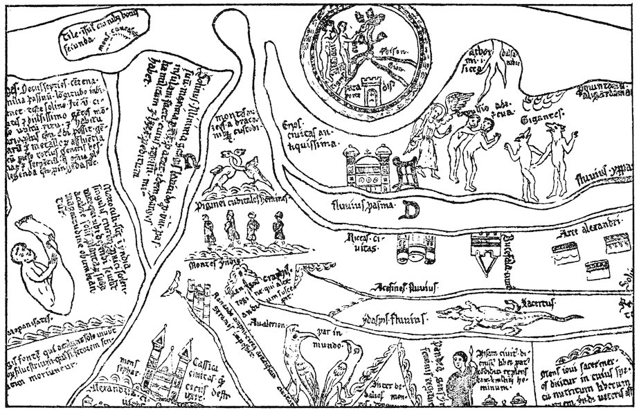
Fig. 8—Two sections from the Hereford map to illustrate the marvels of India. (From the reproduction accompanying Miller, Mappaemundi, vol. iv, 1896.) In this first section are shown, among others, a skiapod, or sunshade-footed man (to the left), and cynocephali, or men with dogs’ heads.
277
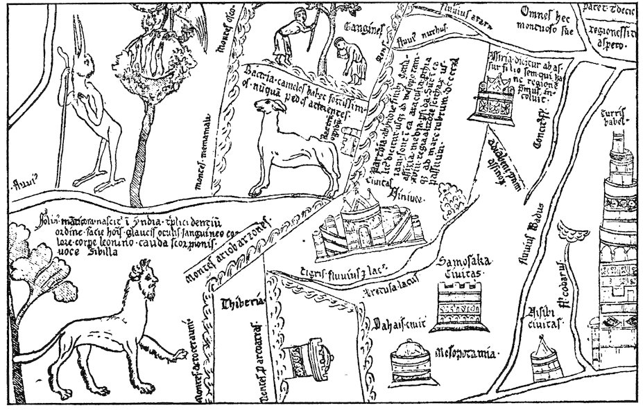
Fig. 8 (second section)—In this section is shown a mantichora, or beast with a man’s head and a lion’s body.
278The stories of St. Thomas and St. Bartholomew were often retold during our period, notably, for instance, in the Historia ecclesiastica of Ordericus Vitalis.[1297] The Osma Beatus map[1298] shows heads representing the twelve apostles in the various countries of the world; that of St. Thomas is placed in India (see Fig. 4, p. 123, above). The unknown writer of the Letter of Prester John was undoubtedly familiar with the legend of St. Thomas, because he makes Prester John’s palace correspond exactly to the palace built by the saint.[1299] This legend was a favorite subject for representation in the sculptures of cathedrals and stained glass windows of the twelfth and thirteenth centuries.[1300]
Visit of Patriarch John of India to Rome
Belief in the existence of a large Christian population in Asia was reënforced by an obscure event that took place in Rome in 1122. We have an anonymous account[1301] of the visit of a certain Patriarch John of India in that year and of the stupendous sensation which it created in the Roman curia and throughout the whole of Italy. The narrator informs us that in the course of countless ages no native was ever known to have come from those distant and barbaric Oriental regions, nor had any one ever before been seen in Italy who had actually been there.[1302] The purpose of the patriarch’s visit to the West originally was to procure at Byzantium the pallium and the confirmation of his office, which he had recently assumed on the death of his predecessor. At Byzantium, however, being told that Rome was in reality the capital of the world,[1303] he proceeded thither along with some homeward-bound Roman ambassadors and while in Rome gave a 279lecture about his native country before the papal curia. The principal city, he said, was Hulna, on the river Pison, one of the four rivers of Paradise; the city was of huge size, surrounded by gigantic walls and inhabited by faithful Christians. Outside the walls there was a mountain encircled by a very deep lake and on the top of the mountain was situated the Church of St. Thomas. Surrounding the lake were twelve monasteries erected in honor of the twelve apostles. The Church of St. Thomas was inaccessible except once a year, when the waters of the lake disappeared, allowing pilgrims to approach. The Patriarch John then went on to explain in considerable detail the marvels and miracles connected with the church.
We should be inclined—and justifiably—to reject the story of Patriarch John’s visit as wholly fanciful, did it not seem to be confirmed by a letter[1304] to a certain Count Thomas written by Odo, abbot of St. Remi in Rheims (1118–1151), who happened to be in Rome at the time John was there. The report of Odo about this event was probably not derived from the anonymous account, from which it differs in several minor details. Among other matters, according to Odo, John speaks of a river, not a lake, surrounding the shrine of St. Thomas and of how its waters diminished as a result of drought and became passable to a boy of seven years during eight days before and eight days after the festival of the apostle. The whole clergy and (Christian) people of India were said to gather here on this occasion.
We shall see shortly that these stories contributed to the formation of the curious medieval belief in the existence of a great Christian kingdom in the heart of Asia. First, however, we must consider what notions were current regarding the seas and islands to the south of India and the vast tracts to the northward beyond the Himalayan barrier.
Indian Ocean
A very brilliant feature on the maps of our period is the Red Sea, almost invariably colored red. This name was given to the entire Indian Ocean, and the red color was applied to the Persian Gulf as well as to the “Arabian Gulf,” or Red Sea proper. The 280name “Indian Ocean” was also occasionally used, as, for example, on the Jerome map of the East.[1305]
The Greeks had acquired some fairly correct information about the northwestern shores of the Indian Ocean and had heard vague rumors of the great peninsula and islands east and south of India: Malaya, Ceylon, Sumatra. Confused reports of the geography of Taprobane, or Ceylon, are found in classical works as far back as the time of the expedition of Alexander. Pliny, Solinus, Ptolemy, and others described Taprobane in some detail but exaggerated its dimensions to enormous proportions. Pomponius Mela had spoken of the islands of Chryse, lying off the eastern promontory of Asia, and Argyre, off the mouth of the Ganges. Perhaps these represented some vague knowledge of the Andamans or Nicobars or the Malay Peninsula; and certainly we recognize the last-named in the Aurea Chersonesus of Ptolemy.
Islands of the Indian Ocean
Some relics of this classical knowledge of Indian seas and isles was retained in the Middle Ages. Isidore[1306] had spoken of “Chrisa” and “Argare” as full of gold and silver and perpetually blooming flowers, with mountains of gold guarded by dragons and griffons. This account found its way into the De imagine mundi[1307] and was copied by Gervase of Tilbury;[1308] the islands themselves, together with the “Island of the Sun” of Pliny, Mela, Solinus, and others, figured on many contemporary maps.[1309] Orosius had said that in Taprobane there were ten cities.[1310] Isidore, whom Gervase of Tilbury copied, added that the dimensions of the island were 875 by 625 miles, that it has two summers and two winters each year, and that the vegetation always remains green.[1311] Solinus had described[1312] Taprobane as being divided in two by a river; one half, he said, was full of wild beasts, but the other was inhabited by men. This division of the island is perpetuated on the Henry of Mayence,[1313] Jerome,[1314] Hereford,[1315] and Ebstorf maps.[1316]
Al-Battānī on the Indian Ocean
The geographical chapter in Al-Battānī’s Astronomy, probably compiled from a redaction of Ptolemy’s Geography and translated 281by Plato of Tivoli in our period, gave a description of the seas of the world.[1317] The Indian Ocean, Al-Battānī said, extends from the land of the negroes to the extreme limits of India, a distance of 8000 miles. Its width was 2200 miles, of which 1900 (Plato of Tivoli mistakenly translated this 3900) reach south of the equator. What lands lay beyond are not specified. From this sea four gulfs run into the land: first the Barbaric Sea, which extends into the “land of the negroes,” or Ethiopia, and may be the Gulf of Aden or possibly even Mozambique Channel; second, the Green Sea (Mare Viride), or our Red Sea, which reaches towards Hyla (Ailah?); third, the Persian Gulf (Mare Persicum); and, fourth, a second Green Sea, running out to the east towards China (“Thinae”) and representing the Bay of Bengal or possibly the China Sea. In the Indian Ocean there are some 1370 islands, among them a very large one called “Tibiariae” (Taprobane), or Sarandib (Ceylon), opposite the eastern coast of India, 3000 miles in circumference, full of great mountains and rivers, quantities of rubies and hyacinths, and surrounded by fifty-nine lesser isles. The traditional account of the many isles of the Indian seas so persistent in Arabic literature arose unquestionably from familiarity with the vast Malay Archipelago or at least with its western portion. On the other hand, whether we may assume, as some have done, that the exaggerated classical and Arabic estimates of the size of Ceylon had their origin in rumors of the existence of Australia[1318] is an obscure problem which we cannot attempt here to solve.
Scythia and Central Asia
North of the mountain barrier enclosing India lay lands about which Western medieval knowledge was equally vague. “Upper Scythia, stretching from the Caspian Sea to the Seric Ocean and southward to the Caucasus, includes much habitable land but also much that is sterile: gold and gems abound there, but men avoid them on account of the griffons. Lower Scythia adjoins Hyrcania, so called from the Hyrcanian Forest, where a marvelous bird is found whose plumage glows in the dark. Iranea, or Iran, is next to Scythia on the west: a region of nomads who 282wander widely because of the sterility of the soil and who are horrible and ferocious (portentuosi ac truces), eaters of human flesh and drinkers of human blood.” In about these terms the author of the De imagine mundi and Gervase of Tilbury, borrowing from Isidore,[1319] summed up very nearly all that was known of Central Asia before the great overland journeys of the thirteenth century to which brief reference has already been made.[1320] Several of the maps show large rivers—Araxes, Oxus, Oscorus, and even Acheron, the stream of Tartarus—rising in the Caucasus and flowing northward into the Caspian.[1321] The latter, in accordance with the usual classical tradition, is represented as a gulf of the encircling Ocean Stream.
Benjamin of Tudela on Central Asia
Benjamin of Tudela, who himself journeyed at least as far east as Baghdad, had opportunities for gaining information about Central and Northern Asia more favorable than those of his less traveled contemporaries. Samarkand he mentions briefly as a “great city on the confines of Persia” inhabited by 50,000 Jews. “Thence,” he adds, “it is four days’ journey to Tibet, the country in whose forests the musk is found” (Adler’s translation).[1322] He quotes the reports of Persian Jews that four of the lost ten tribes of Israel dwell in the mountains of Naisabur (in eastern Persia). These people were said to be independent and to dwell in a broad tract of land twenty days’ journey in extent, with cities and large villages among the mountains.[1323] Others associated the lost tribes with the abhorrent hordes of Gog and Magog.[1324] Benjamin goes on to tell us that these Jews were in league with the “Kufar-al-Turak, who worship the wind and live in the wilderness and who do not eat bread nor drink wine but live on raw, uncooked meat. They have no noses, and in lieu thereof they have two small holes through which they breathe” (Adler’s translation).[1325] He relates the confused story of wars between these undeniably Turanian tribes of the steppes of Turkestan and the “King of Persia” (the Seljuk Sultan, Sanjar), events which perhaps gave rise to a legend that became widespread in twelfth-century Europe and to which we must now turn.
283 Prester John
The legend was the romantic story that in these far regions there lay a vast and powerful Christian kingdom ruled by a mighty potentate, Prester John. This tradition was the most important contribution of our period to regional geography, for, false as it was, it long persisted, became an integral part of late medieval geographical theory, and exerted in subsequent centuries a powerful influence on the course of exploration. The thirteenth-century Oriental travelers were constantly on the lookout for Prester John’s kingdom and, when it finally became obvious that there was no such kingdom in Asia, Prester John was transferred to Africa, where he was sought for by the Portuguese navigators of the fourteenth and fifteenth centuries. How did this strange legend come into existence, and what did it contribute to Western notions of Asia?
Origins of the Legend
Various elements seem to have given rise to it. Perhaps rumors of the existence of a Christian nation in Abyssinia may at a very early period have fostered belief in the existence of a great Christian potentate in Asia. India in Asia and Ethiopia in Africa were often confused both in antiquity and during the Middle Ages. Furthermore, the story of the visit of the Indian archbishop or patriarch, already referred to, encouraged belief in a numerous Asiatic Christian population. Some of the elements of the patriarch’s report became an integral part of one of the twelfth-century versions of the story of Prester John.
Then again, we have echoes of actual events in the East in Benjamin of Tudela’s Itinerary, as we have just seen, and in Otto of Freising’s Chronicon. Otto relates[1326] that in 1145 the bishop of Gabala in Syria had come to Viterbo to report to Pope Eugenius III, among other things, the fall of Edessa. Here Otto met the bishop, and what he learned is recorded in the Chronicon. This was to the effect that, not very long before, a certain John, king and priest, who dwelt in the Far East beyond Persia and Armenia and who, together with his tribe (gens), was a Christian, waged war with the Samiards (Saniards), two 284brothers who were kings of the Medes and Persians. John captured Ecbatana, the capital of the Samiards’ realm, defeated the brothers in battle, and put them to flight. He then proceeded to advance to the aid of the church at Jerusalem but was hindered from going very far by the river Tigris. Turning northwards in hope that the river would freeze over and thereby enable him to cross, he was finally constrained, after several years had elapsed, to give up the enterprise because continued warm weather prevented ice from forming. This John, Otto added, was said to have come of very ancient lineage, in fact, to have been one of the progeny of the Magi. The tribes under his command were perhaps the same as the “Kufar-al-Turak” of Benjamin of Tudela.[1327]
Though the attempt has been made to identify the Christian potentate of the legend with a chieftain of the Caucasus,[1328] the weight of evidence would seem to favor belief that the story in its more specific thirteenth-century form grew out of rumors of some Christian Mongol lord of Central Asia.[1329] It is certain that the Nestorian form of Christianity was strongly represented in Central Asia during this period and that two powerful tribes of these distant regions, the Keraïts and the Onguts, formed outposts of this faith. But, as Pelliot writes, “whatever may have been the origin of the famous legend of Prester John, ... it was to a prince of the Keraïts that the tradition was applied during the first half of the thirteenth century. All the Keraïts spoken of in the history of the Mongol dynasty seem to have been Christians; in any case this is true of the majority of them. In fact it was through marriage with Keraït princesses that Christianity penetrated even into the family of Jenghiz Khan.”[1330] Many of these Asiatic Christians bore Christian names preserved in Chinese forms, such as Yao-su-mu for Joseph or K’wo-li-ki-ssö for George.[1331] We learn from Marco Polo and other thirteenth-century travelers that Mongol princes often submitted to baptism, though this was probably done out of indifference to religion rather than as the expression of any deep-seated convictions.
On such slender foundations as the report in Otto’s Chronicon or the anonymous account of the visit of the Patriarch John to 285Rome or on other rumors of events in the heart of Asia of which no record has been preserved, there was erected an elaborate, detailed, and wholly fanciful series of descriptions of Prester John and his realm, embellished by borrowings from the Romance of Alexander, from the legend of St. Thomas, and from that world of fable which constituted the medieval European conception of the Orient.
Prester John’s Kingdom As Described in His “Letter”
The most important description of Prester John’s kingdom is contained in the famous Letter, addressed in some manuscripts to Manuel, the Byzantine Emperor, in others to Frederick, the Roman Emperor; in still others, to the Pope. In this letter,[1332] the earliest version of which dates from before 1177, John tells that he is superior in wealth and power to all the kings of the world. His realm includes the three Indias and St. Thomas’ shrine. It extends across the desert of Babylon to the tower of Babel and contains seventy-two provinces, each ruled over by a king. Prester John is lord of the Amazons and Brahmins. In one direction his territory reaches out four months’ journey. In the other, no one can tell how far. “Only if you could count the stars of the heaven and the sands of the sea would you be able to form an estimate of our dominion and our power.” Many are the extraordinary features of this realm which abounds in milk and honey: here is one of the rivers of Paradise; here are streams that give forth gold and jewels; here pepper is gathered; here is the fountain of youth; and here a mysterious sea of sand fed by a river of rocks, beyond which dwell the ten tribes of the Jews, who, although they have their own kings, are nevertheless subject to the mighty Christian ruler. In one of the provinces near the torrid zone the salamander thrives, a “worm” which cannot live without fire and which makes a chrysalis about himself as do the silkworms (an interesting and unexpected bit of natural history embedded in the midst of fable). Prester John takes particular delight in expatiating on the enormous wealth of his country, on the virtues of its inhabitants—for among them there are neither liars nor adulterers nor indeed vice or crime of 286any description—and on their clemency and Christian piety. Every year the king makes a pilgrimage with his army across the serpent-infested Babylonian desert to the shrine of the prophet Daniel. A large part of the Letter is taken up with a minute description of the royal palace—exactly like that which St. Thomas built for the King Gundophorus, of the king’s household, the grandees who wait upon him, the officials of the kingdom, etc., etc. In an early Latin version of the Letter, written probably in England, we are informed that there are people from all countries of the world at Prester John’s court;[1333] among the personal servants of the king there are Englishmen who wait upon him at table. No less than eleven thousand Englishmen are in his bodyguard, and every Englishman who comes to the court, whether clerk or knight, is invested with the order of knighthood. The French and Italian versions of the Letter, which were probably translated from this Latin text, substitute “François” and “Franceschi” for “Anglici.”
Alliance With Prester John Desired
During the thirteenth century it was the vain hope of the Popes and of the Christian kings of Europe to gain the alliance of some great power in the East—either the Mongols or Prester John—as an offset to Turkish encroachments on the Crusaders’ frontiers.[1334] Perhaps we may detect the beginnings of this policy in a letter of Pope Alexander III (1177) to John, “Magnificus rex Indorum sacerdotum sanctissimus.”[1335] The Pope informs the great king that he has heard of his piety through a certain Master Philip, papal physician, who had held conversation with distinguished and honorable persons of his realm. Consequently Alexander was sending this Philip to expound to him the tenets of Western Christianity and to convert him to the true Catholic faith. It seems probable that Alexander was acquainted with the supposed letter of Prester John to the Byzantine Emperor, though there is also strong probability that he had confused the stories of the Asiatic Prester John with reports regarding the Christian kingdom of Abyssinia—a source of much confusion at a later period than ours.
287 Gog and Magog
The northern part of Asia was the reputed seat of the terrible tribes of Gog and Magog, whose eruption at the Last Day was destined to bring about the destruction of the human race. We have seen that Biblical prophecies were combined with the story of Alexander the Great’s enclosing of these tribes behind great walls. The legend appears in our period under various forms. Most of the maps show Gog and Magog, usually surrounded by a wall; some add disparaging epithets, such as “gens immunda.” Matthew Paris on his map of Palestine indicates in the north the walls whereby King Alexander the Great shut in Gog and Magog and states in the explanatory legend that from this same direction came the Tatars.[1336] In the De imagine mundi[1337] we find a simple statement that between the Caspian Mountains and the sea of that name dwelt those tribes who had been walled in by Alexander the Great, Gog and Magog, the fiercest of all peoples, eaters of the raw flesh of wild beasts and of human beings. The Moslems had placed Gog and Magog in the farthest corner of northeastern Asia: and in John of Seville’s translation of Al-Farghānī’s Astronomy we find the land of Gog at the easternmost extremity of the sixth and seventh “climates” (those farthest north).[1338] Lambert li Tors speaks in the Romance of Alexander of “Gos et Magos” among the vassals of Porus: though they came forth with four hundred thousand men, Alexander, after he had defeated Porus, chased them back into the defiles of the mountains, where he shut them in with a great wall.[1339] In a later part of the Romance, the subdivision of Alexander’s kingdom at his death is explained: to Antigonus was given Syria and Persia as far as Mount Tus, together with the duty of standing guard over Gog and Magog.[1340] Otto of Freising also mentions these tribes.[1341] He derived his information from Frutolf’s Chronica,[1342] whence, in turn, it had come from the version of the Romance of Alexander known as the Historia de praeliis. In the days of Heraclius, Otto says, the “Agareni” (Saracens) devastated the lands of the empire and destroyed part of the army of Heraclius. In revenge the latter opened the Caspian Gates and let out those most savage tribes, which Alexander the 288Great had enclosed along the Caspian Sea on account of their heinousness, and inaugurated a war against the Saracens. By night, as a punishment sent by the Deity for this sacrilegious act, fifty-two thousand of Heraclius’ army were struck down by lightning, and, as a result of this terrible visitation, Heraclius himself died in the twenty-seventh year of his reign.
There were many variations of the legend of Gog and Magog. Elsewhere in Otto of Freising’s Chronicon[1343] we find an account, taken from Orosius, of the way in which Artaxerxes forced many of the Jews to dwell in Hyrcania near the Caspian Sea. It was believed that these people had multiplied greatly,[1344] and they were expected to burst forth on the world in the days of Antichrist. Though not here expressly called Gog and Magog, the connection is plain; and Godfrey of Viterbo relates how Alexander enclosed Gog and Magog, the “eleven [sic] tribes of the Jews.”[1345] We have already quoted[1346] Matthew Paris’ description of the Tatars who, he said, might be the same as the tribes whom Alexander enclosed—the ten tribes of Israel.
Western Asia
When we turn from the remote parts of the Orient to Western Asia we find ourselves in regions much better known to the Western world, though the traditional geography of these regions, founded on classical and Biblical authority, persisted in encyclopedic writings hardly influenced at all by the contacts that in reality had been established. The De imagine mundi, Gervase of Tilbury’s Otia imperialia, and other similar works add little to what Isidore and Orosius had written. Between the Indus and Tigris lie many countries, Arachosia, Parthia, Assyria, Persia, Media, all forming a harsh and mountainous tract called in Scripture “India” but more generally known as Parthia. Fire had been discovered in Persia.[1347] The Tigris, so called because it is as swift as a tiger, rises from a common source with the Euphrates in the mountains of Armenia.[1348] Thence the two rivers separate, leaving a long space between them known as Mesopotamia; the Tigris encircles Assyria and empties into the Dead Sea! Peter Comestor and the author of the De imagine 289mundi accepted the views of Isidore regarding the source of the Tigris in the highlands of Armenia,[1349] but the latter adds to the already prevailing confusion by stating that both rivers of Mesopotamia debouch into the Mediterranean Sea. Gervase, on the other hand, corrects the error of the author of the De imagine mundi by making them flow into the Red Sea (or Indian Ocean),[1350] as was depicted on most maps.
Mesopotamia
Mesopotamia was said to be famous as the site of Nineveh and of Chaldea, where astronomy was discovered;[1351] and Gervase of Tilbury dilates on the immense size of the walls of Babylon.[1352] Regarding Babylon, it is refreshing to find in Otto of Freising’s Chronicon some really up-to-date information which he had derived from Frutolf.[1353] In the first place, he makes a careful distinction between Babylon and Cairo, to which the name of Babylon was commonly given. “Old Babylon,” he added, “as we learn from reliable men from across the seas, is partly inhabited at the present day and now called Baldach [Baghdad]. Part, however, as you would expect from the words of prophecy, is a desert waste extending for ten miles as far as the tower of Babel. The part which is inhabited and called Baldach is very large and populous.” He explains that here is the seat of the greatest priest of the Persians, whom they call “Caliph,” and who holds in some respects a position among these pagans parallel to that which the Pope at Rome holds among Christians.
With Baghdad we have at last come to a city that was actually visited and described during our period by Western Europeans whose descriptions have come down to us. The Jewish travelers, Benjamin of Tudela and Petachia of Ratisbon, appear to have sojourned in the Mesopotamian city in the seventh and ninth decades of the twelfth century respectively.
Benjamin of Tudela on Baghdad
Benjamin’s personal familiarity with Baghdad saved him from making Frutolf’s and Otto’s mistake of confusing the Abbasid capital with old Babylon. We gather from Benjamin’s Itinerary that 290the latter is three days’ journey distant and that “the ruins of the palace of Nebuchadnezzar are still to be seen there, but people are afraid to enter them on account of serpents and scorpions” (Adler’s translation).[1354]
Baghdad, Benjamin writes (our quotations are from Adler’s translation), “is on the River Tigris,” which “divides the metropolis in two parts.” The city “is twenty miles in circumference, situated in a land of palms, gardens, and plantations, the like of which is not to be found in the whole land of Shinar. People come thither with merchandise from all lands. Wise men live there, philosophers who know all manner of wisdom, and magicians expert in all manner of witchcraft.”[1355] Benjamin was particularly interested in the Caliph, of whose palace, park, family, and widespread authority he writes in no little detail and in highly commendatory terms,[1356] for it seems that the Caliphs were more tolerant toward the Jews than were most Christian monarchs of the age. Besides treating of the Caliph, Benjamin tells about the “Head of the Captivity,” another powerful ruler whose headquarters were Baghdad and in whom the Caliph had vested authority over all the Jewish communities throughout the eastern Moslem world. A descendant of David, King of Israel, he was a man of great dignity and rank, held high in the esteem of the Mohammedans. His power extended “over all the communities of Shinar, Persia, Khurasan, and Sheba, which is El-Yemen, and Diyar Kalach (Bekr) and the land of Aram Naharaim (Mesopotamia) and over the dwellers in the mountains of Ararat and the land of the Alans, which is a land surrounded by mountains and has no outlet except by the iron gates which Alexander made but which were afterwards broken. Here are the people called Alani. His authority extends also over the land of Siberia [Sikbia?] and the communities in the land of Togarmim[1357] unto the mountains of Asveh and the land of Gurgan, the inhabitants of which are called Gurganim who dwell by the river Gihon (Oxus?); and these are the Girgashites who follow the Christian religion. Further it extends to the gates of Samarkand, the land of Tibet, and the land of India. In respect of all these countries the Head of the Captivity gives the communities power to appoint Rabbis and Ministers who come 291unto him to be consecrated and to receive his authority. They bring him offerings and gifts from the ends of the earth.”[1358]
Whether or not Benjamin was personally presented to the Head of the Captivity we are not informed. In any case he undoubtedly came into contact at Baghdad with Jews from all over Central and Western Asia and from them was able to gather those details regarding the Jewish communities which form such an important and interesting part of his Itinerary. Most striking in this connection are the data which he furnishes us about the Jews of Arabia.
Benjamin of Tudela on Arabia
The interior of that great peninsula until recently has remained very vaguely known to Western Christians, and in the Middle Ages there reigned almost complete ignorance regarding it. Gervase of Tilbury tells us (from Orosius) that Arabia lies between two seas and is the country of Mount Sinai, of the Queen of Sheba, and of frankincense.[1359] Beyond this and a few details about the Bedouins picked up by the Crusaders, nothing was known. Hence the information which Benjamin gives on the Jewish communities is of exceptional importance. If we may trust his figures, it would seem that there was at this time a large Jewish population both in Yemen and farther north. Benjamin’s conception of the geography of the peninsula, however, is remarkably confused. He tells us that at a distance of twenty-one days’ journey through the deserts from Hillah in Mesopotamia one comes to the land of Saba, or El-Yemen. Here he places the great Jewish cities of Tanai, Tilmas, Teima, and Kheibar. Neither Tilmas nor Tanai have been definitely identified. To the former Benjamin assigned a population of 100,000 Jews; to the latter, with the district surrounding, a population of no less than 300,000 Jews. They may represent Jewish settlements in Yemen, though Benjamin’s statement that Tilmas is only three days from Kheibar would seem to preclude this possibility. Tanai, on the other hand, has been thought to be Sanaa. Kheibar (to which Benjamin assigns 50,000 Jews) and Teima have long been well-known towns of northern Arabia not far from Medina. Now inhabited by half-breed negroes, these places were the centers of a Jewish 292population from before the times of Mohammed until as late as the sixteenth century.[1360]
Ina totally different connection Benjamin refers to Jews of the “land of Aden,” which he believed to be part of India, taking India to include southern Arabia and Ethiopia. Their country he describes as mountainous. The Jewish element in the population, he adds, “are not under the yoke of the Gentiles but possess castles on the summits of the mountains from which they make descents into the plain country called Libya, which is a Christian empire” (Adler’s translation).[1361] This is indeed confusing. If by Libya Abyssinia is meant—which is likely, for Abyssinia was a Christian kingdom from very early times—it seems peculiar that Benjamin makes no mention of the Red Sea intervening between the land of Aden in Arabia Felix and the African coasts which would have to be crossed by Jews of the Aden highlands in making war on the Abyssinians. Possibly Benjamin, like Marco Polo a century later, conceived of Aden as lying in Africa.[1362]
Syria and Palestine
Unlike all the rest of Asia, Syria and Palestine were well known at first hand to many European Christians. Yet, in writing about them, the makers of compilations like the De imagine mundi and the Otia imperialia were content to do little more than copy Isidore’s dry catalogue of the names of places rendered famous through Scriptural associations.[1363] The Dead Sea with its sinister neighborhood was the only natural feature of this part of the world which seems to have made a strong enough appeal to the imagination of these writers to impel them to add anything to what Isidore had said long before.[1364]
Geographical Knowledge Enlarged by the Crusades
On the other hand, the Levantine countries were familiar through the journeys of Western travelers, though their observations were not incorporated into the works of the scholarly compilers. Many were the motives that induced men of the West to visit the Nearer East. Religious enthusiasm and the desire for commercial gain, however, were paramount. The Crusades 293contributed more than any great series of events between the time of Claudius Ptolemy and the middle of the thirteenth century to the broadening of man’s geographical horizon, and, with it, the broadening of the whole range of human activity. We cannot attempt to discuss these wider aspects of the Crusading movement in any detail, but a few words must be said about the dissemination of regional knowledge that resulted from it. Feudal nobility, soldiers, pilgrims, and adventurers of all sorts and from all parts of the West were joined by Italian merchants in the great enterprise, the object of which was not only to redeem the holy places from the infidel but also to profit from the Levantine trade. Men of all ranks and callings, coming from every part of Christendom, made their way by land and sea to the Holy Land. Peasant, serf, and petty townsman, as well as powerful noble and church dignitary, were torn from old and familiar environments to wander through countries about which they had hitherto known next to nothing. In some cases the stories of their travels and adventures were preserved in chronicles and poems, but in most no permanent record was left. Nevertheless, the geographical knowledge of the average man was widened to an extent which we can scarcely appreciate at the present day. Before the Crusades communities throughout the greater part of Europe had lived very much to themselves, in limited contact with the outside world; but by the year 1200 it is safe to infer that practically every town and village of France, England, Germany, and Italy held someone who had visited the East and was not unready to tell about what he had seen there and on his way out and back. Just as the War of 1914–1918 has taught the world much European geography, so the Crusades taught all classes of Europe about the Holy Land and the routes thither. But the Crusades did more than give the people a wider knowledge of places: they brought them into contact with new customs, new religions, new ideals and modes of life, as well as with new types of landscape and terrain. All this tended to displace men from habitual and local modes of thought; Europe became more cosmopolitan, and the way was prepared for that profound change in man’s entire attitude towards life which we now call the Renaissance.
294 Occidental Population of the Levant
We can merely hint at these general results of the extension of geographical contact with the Levantine world and turn to the more specific problem of the limits to which Western penetration was actually pushed. The Occidental population of the states established after the First Crusade along the eastern border of the Mediterranean was composed primarily of the Frankish nobility and soldiery and of Italian traders.[1365] The former had established themselves in castles and garrisons, from which they ruled over widespread manorial estates tilled by native Syrians. The traders occupied large foreign quarters in such commercial centers as Acre, Jaffa, Ascalon, Tyre, and Tripoli on the coasts, and in the interior at Jerusalem. Trading privileges and the right to build up commercial colonies in the towns were granted to Genoese, Pisans, Venetians, and others in return for services rendered the Crusading armies by the Italian navies in the conquest of the coast towns and in the transportation of military forces. Through the reports brought back to Europe by returning soldiers, adventurers, and merchants, Syria and Palestine became more widely and accurately known in the West than most parts of Europe itself.
European Occupation of Syria
First-hand acquaintance with the Levant, however, did not, either in the twelfth or in the thirteenth century, necessarily lead to first-hand acquaintance with the neighboring countries that still lay under the domination of the Turk. At the time of its greatest extent the Kingdom of Jerusalem reached eastward to the edge of the desert plateau beyond the Jordan and Dead Sea and southward to Ailah on the Gulf of Akaba. Northeastward the upper Tigris marked the frontier of the County of Edessa. Beyond these restricted borders lay Saracen territory into which traders from the West did not dare to venture. Southern Mesopotamia was virtually terra incognita; and the men who held the small garrison posts along the eastern border of the states of the Crusaders were not prone to undertake rash enterprises in the enemy’s country.
The danger of such enterprises is illustrated by the fate of a 295Christian naval expedition sent down the Red Sea from Akaba in 1182–1183.[1366] A small fleet, fitted out by Reynauld of Châtillon, lord of the castle of Kerak beyond the Jordan, succeeded in getting almost as far as Yembo, the port of Medina. We are not told of its true purpose by the Arabic historians, who alone seem to have recorded this adventure, though the Arabs certainly believed that the Crusaders were bent upon plundering the tomb of the prophet at Medina. Perhaps its leaders harbored a fanatic hope of attacking the holy cities of Islam. At all events, the navy of Saladin, hastily summoned from Egypt, soon overtook and defeated the little squadron at Haura, and those of the Crusaders who escaped ashore were either killed by the Bedouins or sold into slavery.
But though, with a few exceptions, Europeans themselves did not go beyond these bounds of the Crusaders’ states, commercial relations were established with the more eastern regions.[1367] Antioch and Laodicea were the termini of two trade routes from Aleppo, whence came merchants from Rakka on the Euphrates and ultimately from Mesopotamia, Persia, and Central Asia. Asiatic goods were also sold at a great open fair in the Hauran country, at one time in the territory of the Kingdom of Jerusalem and undoubtedly frequented by Westerners. And the harbors of the kingdom were the entrepôts of an extensive traffic from Arabia Felix and India by the Red Sea and across the Isthmus of Suez. At all of these points the Italians established connections with the Oriental merchants and learned from them much about Oriental lands and their products.
Asia Minor
During the early thirteenth century Asia Minor also became familiar ground to the men of the West.[1368] The establishment of the Latin Empire at Constantinople in 1204 during the Fourth Crusade was mainly responsible for this; but even before the close of the twelfth century the Venetians had become preponderant from a commercial point of view in the districts that had hitherto formed parts of the Byzantine Empire, and after 1204 they were in a position to conclude advantageous treaties with their Anatolian neighbors, Greek, Seljuk, and Armenian. Venetian merchants 296were to be seen in the important towns and along the highways of the peninsula. Italians, with Provençaux in their train, exploited the trade of the small Christian kingdom of Little Armenia (the ancient Cilicia) and penetrated from the Mediterranean into and across the Seljuk sultanate of Iconium, whose rulers were disposed to look with fairly friendly eyes on the Frankish trader. Even the Empire of Nicaea, a small remnant of the Greek dominions which had managed to preserve its independence after the Fourth Crusade, was constrained in 1219 to grant extensive trading privileges to the Venetians.
Western Asia As Described by the Crusaders
The knowledge of Western Asia acquired in these various ways was naturally enough reflected in the works of the historians, chroniclers, and poets of the Crusades, many of whom had themselves visited the places they describe. Their fresh and realistic accounts contrast strikingly with the sort of geographical writings we have so far been discussing in this chapter. From Dreesbach’s study of the Orient as described in the early French Crusading literature we may gain a concise idea of the sort of thing that impressed itself on the mind of the Occidental.[1369] His impressions of climate and landscape need not detain us here, as they have already been explained in early chapters.[1370] Of the natural resources, the wealth of the fruits of Syria, grapes, figs, pomegranates, almonds, olives, and locusts, were often the subject of wonder and admiration, and William of Tyre speaks enthusiastically of the great sugar plantations at Sur.[1371] Of the animals,[1372] the Arab horse and the camel attracted most attention; and the usefulness of the latter was known both as a beast of burden and as a swift traveler through the desert. A lively sketch of a man leading a camel laden with a large cask figures prominently on one variant of the Matthew Paris map of Palestine, and a legend reads: “Here abound camels, buffaloes (bubali), mules, and asses, which are used by the merchants trading between the peoples of the Orient and of the Occident.”[1373] Bears and lions, serpents and tarantulas, and carrier pigeons also invited notice; and the mosquito is mentioned by Ambroise, who says that though very 297small it has a terribly poisonous bite, bad enough to make every one, old and young alike, appear to be leprous:
“Que chescons, vielz ou damoisels,
Sembloit a estre tut mesels.”[1374]
Concerning the people[1375] of the Levant we find that the distinction between the nomadic desert-dwelling Bedouins and the bearded turban-wearing Saracens (townsfolk) was well understood. The Bedouins—contrary to their present reputation—were looked down upon as cowards in battle, and William of Tyre relates with some disgust that it was their custom to hang about on the outskirts of a fight until they saw which side was going to win and then to join the victors.[1376]
In commenting on the religion[1377] of the Saracens the medieval Christians made the fundamental error of supposing that Islam is an idolatrous cult and that Mohammed was worshipped as a god. Nevertheless they were far from inaccurate in their remarks on the various customs, habits, and minor beliefs of the Moslems, on such matters, for example, as the pilgrimage to Mecca, the prohibited eating of pork and drinking of wine, the importance of ablutions, polygamy, and the customs of divorce. William of Tyre describes[1378] the division of the Mohammedans into two great groups, Shiah and Sunni, and explains how the former held that Ali (“Haly”) was the only true prophet and the latter that Mohammed was the one messenger of God. Baghdad was referred to as the seat of the great “apostle” of the Saracens, or caliph, whom William of Tyre spoke of as a sovereign prince and chieftain whom all must obey; Cairo in Egypt was recognized as the capital of the caliphs of the rival Shiah persuasion.
Benjamin of Tudela also acquired some fairly clear ideas of Islam during his visits to Baghdad and to Egypt. He states that the Abbasid Caliph at Baghdad “is head of the Mohammedan religion, and all the kings of Islam obey him” and likens his position to that of the Christian Pope.[1379] In writing about Cairo he tells us that the subjects of the Emir were followers of Ali (hence Shiites), that they rose against the Abbasid Caliph of Baghdad, and that a lasting feud was kept up between the two factions.[1380]
298Particular terror was inspired in the hearts of the Crusaders by that strange sect of Assassins,[1381] whose principal seat was at Alamut in Persia, the stronghold of the notorious Old Man of the Mountain, though most of the Crusaders mistakenly thought that the outlying fortress of Massiat in Syria was the abode of the Old Man. William of Tyre dilates[1382] on the treachery and murderous nature of this people; and in Ambroise’s Estoire we find[1383] a vivid account of how the children of the Assassins were brought up to do the bidding of the Old Man in every detail and in particular to bring about the murder of his enemies.[1384]
AFRICA
Egypt As Part of Asia
Both the author of the De imagine mundi and Gervase of Tilbury include an account of Egypt with their descriptions of the countries of Asia. They then take up the remainder of Asia and Europe before finally returning to Africa toward the close of the geographical parts of their books. This order of treatment, which accorded with classical traditions, usually included Egypt with Asia or at least, as in the De imagine mundi, made the Nile rather than the Red Sea the boundary between Asia and Africa.[1385] Certainly from an historical and cultural point of view Egypt has been more closely related to the Asiatic than to the African continent, even though geographically it forms a portion of the latter.[1386]
The description of Egypt in the Otia imperialia[1387] was copied in large part from the De imagine mundi,[1388] and this in turn had closely followed the words of Isidore.[1389] It ran somewhat as follows. Surrounded by the course of the Nile, which forms a letter delta,[1390] Lower Egypt comprises five thousand country estates; these are not watered by rainfall but by the floods of the river alone, for the skies of Egypt are never obscured by clouds. The capital of Egypt is Babylon (Cairo), built by Cambyses. Close to Thebes—a city founded by Cadmus, Agenor’s son and founder of Boeotian Thebes as well—are vast solitudes where there used to dwell a great company of hermits. The De imagine mundi speaks of the island of Meroë and of Syene on the tropic in 299Upper Egypt, the latter famous for the well built there by the philosophers, into which the sun shines directly in the month of June.[1391] The Jerome map of Palestine also shows Egypt in considerable detail, one of the most important features being the lighthouse at Alexandria.[1392]
Descriptions of Egypt
Egypt, like the Holy Land, was frequently visited by Western merchants throughout our entire period. Benjamin of Tudela testifies to the enormous trade carried on there with the West. Alexandria was the principal port whence the spices and luxuries of the Far East were transshipped to Europe. Benjamin spoke with high appreciation of the wide straight streets of the city and of the architectural beauty of its buildings. He was much impressed by the swarm of merchants from all over the world who congregated in its streets and markets.[1393] William of Tyre enlarged on the commercial importance of the great port and explained that the peppers, spices, ointments, drugs, lectuaries, precious stones, and silks of the Orient were brought first to Aden on the Red Sea and thence transported direct to Alexandria. He pointed out that Alexandria was also important as the meeting place of the river and maritime trades, and he gave a description of the local topography of the city.[1394] Merchants from various Occidental nations and city states of Italy had fondachi, or trading stations, in this cosmopolitan metropolis, which was, as Schaube says, more subjected to European influences than any other city of Islam.[1395] The Church endeavored to place severe restrictions on commerce with the infidel, in particular by the prohibition of the importation into Egypt of wood and iron, two materials of vital importance to the Saracens and much in demand. The restrictions, however, were disregarded, and trade flourished between Southern Europe and Egypt throughout nearly the entire twelfth and early thirteenth centuries, except for a short interruption at the time of the Third Crusade. In 1215–1216 there were said to be no fewer than three thousand Frankish merchants in Alexandria.[1396] Egypt was the objective of the Crusaders of the Fifth Crusade, who seized and held the city of Damietta from 3001219 to 1221, and again under Louis IX of France, who held it from 1248 to 1249; but in the interval between these two Crusades the Emperor Frederick II was on friendly and even intimate terms with the sultans.[1397]
William of Tyre, who knew Egypt at first hand, gives a vivid picture of the fertile strip of country, hemmed in on either side by two deserts “in which the land is so burned and sterile that it supports no herb and no manner of tree, except where the river Nile waters the ground when it is in flood; in these parts alone a great abundance of wheat can grow.”[1398] He speaks of the flood of the Nile, between the months of June and September, and how it leaves a rich deposit of silt; of the palm gardens like a forest along the banks of the stream; and of the extensive orchards of fruit trees in the neighborhood of Alexandria.[1399] He also fully describes the caliph’s palace at Cairo and the Mamelukes, or sultan’s bodyguard, recruited from the children of captured enemies.[1400]
Benjamin of Tudela also marveled at the agricultural wealth of the flood plain of the Nile. The river alone, he said, irrigates and fertilizes the land, for “no rain falls, neither is ice or snow ever seen” (Adler’s translation). Among other curiosities he described the Nilometer, which measured the height of the flood waters, and he gave details regarding the agricultural crops and fruits. Benjamin quoted the correct explanation of the flood: “The Egyptians say that up the river, in the land of Al-Habash (Abyssinia), which is the land of Havilah, much rain descends at the time of the rising of the river, and this abundance of rain causes the river to rise and to cover the surface of the land” (Adler’s translation).[1401]