Part 2 — CHAPTER XII REGIONAL GEOGRAPHY (continued 2)
Reading edition
Africa West of Egypt
To the west of Egypt, according to the De imagine mundi, lies Africa, stretching from the Nile to the ocean. Here in order are the provinces of Libya, named from a queen of that name; Cyrenaica, called from the city of Cyrene; Pentapolis, from the five cities of Berenice, Arsinoë, Ptolemaïs, Apollonia, and Cyrene; Tripolis, from the three cities of Occasa, Berete, and Leptis Magna; Heusis, containing the site of Carthage; Getulia; Numidia, with Hippo, the home of St. Augustine; and Mauretania.[1402] The two 301Syrtes (Major and Minor), or shallow bays of the north coast of Africa, are shown on the Henry of Mayence map immediately to the west of Egypt.[1403] In the extreme west of Africa the De imagine mundi, with characteristic confusion, places Gades (Cadiz), from which the adjacent sea is called the Sea of Gades; and, on the borders of the ocean, Mount Atlas, a mountain of immense height, named after Atlas, once a king of Africa.[1404] These mountains also appear prominently on the St. Sever Beatus map as a long range running parallel to the Atlantic[1405] (see Fig. 2, p. 69, above). Other maps of the same group[1406] show two great peaks on the western coast of Africa, which seem to represent a confusion of the Atlas Mountains with the famous Pillars of Hercules. A legend on the St. Sever Beatus map in the neighborhood of Tangier (Tingi) draws attention to the fact that “this region produces monkeys and ostriches,”[1407] true certainly at the present day in regard to the former.
In the fourth and fifth decades of the twelfth century the Norman king of Sicily, Roger II, the patron of Edrisi, conquered many of the seaport towns along what is now the coast of Tunis; and, though the Latins were expelled from this region by the powerful Moroccan dynasty of the Almohads,[1408] who during the following decade came to supersede the Almoravids in the domination over North Africa and Spain, close commercial relations were maintained between the northern and southern coasts of the Mediterranean Sea throughout the century and a half with which we are concerned.[1409] The Genoese held the foremost place in the North African trade; but Pisan, Venetian, Massiliot, and Catalan merchants also frequented the markets of the seaboard towns. Under the Almohads, Ceuta and Bugia were important entrepôts of Genoese trade; and when the Almohad dominions split up in the early years of the thirteenth century (1212–1238), these two towns fell into the hands of Genoa.[1410] Genoese fleets also ventured through the Strait of Gibraltar and not only tapped the commerce of the western coasts of the Iberian Peninsula but penetrated as far as Saleh on the Moroccan shore. Christians also found their way in various capacities into the interior of Maghreb, as the Moslems termed these western territories 302of Islam. During the Crusading epoch many Christians were taken captive in the wars in Spain and by pirates on the high seas; most of these were sold into slavery in the markets of the sea ports of Morocco, Algeria, and Tunis and sent to drag out lives of suffering in the towns of the interior. Towards the close of the twelfth century a Christian religious order was formed for the purpose of ameliorating the sufferings of the captives and of bringing about their redemption by exchange with Moslem captives held in Christendom.[1411] We have evidence that these “Redemptorists,” and the Franciscan and Dominican friars who were soon to follow them in the same work and who also served as ministers of the Christian religion to the European merchants engaged in business in Moslem countries, were not at all inhospitably received.[1412] Their work was facilitated by almost uniformly friendly relations between the papacy and the rulers of Morocco, and the number of Christians in this part of the world became so great by the fourth decade of the thirteenth century that an episcopal see was established in Fez (1233), subsequently to be removed to Morocco City.[1413] Another tie between Morocco and the Latin West was created by the maintenance at the court of the Almohads and their successors of a mercenary force composed for the most part of Spanish Christians from Catalonia and Aragon.[1414]
On certain of the Beatus maps a “sandy desert” is shown between Egypt, western Africa, and Ethiopia;[1415] and on the Psalter map it appears as a well-defined strip of territory labeled “sandy and sterile land.”[1416] This of course is no other than the Sahara,[1417] of which little or nothing was known, except that the Henry of Mayence map shows,[1418] far back in the desert, the Temple of Jupiter (Ammon), in the oasis of that name, known since antiquity, and the St. Sever Beatus map represents certain immense salinae, or salt pits (the two squares west of the Nile on Fig. 2, p. 69, above), said to wax and wane with the moon.[1419]
Ethiopia
South of Egypt and the Sahara lies Ethiopia. In the minds of medieval writers this name was not restricted to the region 303beyond Upper Egypt but was applied to the entire southern part of the known world, just as “India” sometimes was applied to the entire Far East. Indeed, from early classical times Ethiopia had itself been confused with India, and some of the writers whose works we are studying believed that the two regions were coterminous.
Nearly all the maps of the period carried the extremities of Ethiopia far to the east and minimized the size of the Red Sea and Indian Ocean in such a way as to bring Central Africa within no great distance of India. On the Jerome map of Palestine two tracts called “India Egyptii” and “India Ethiopie” were placed along the shores of the Red Sea opposite the mouths of the Indus.[1420] Gervase of Tilbury speaks of three peoples inhabiting Ethiopia: the Hesperi in the west, the Garamantes in the center, and the “Indians” in the east,[1421] and adds that there are one hundred and twenty provinces “from India into Ethiopia.”[1422] The De imagine mundi places Saba, the city of the Queen of Sheba, in the easterly part of Ethiopia.[1423] It was conceded that Ethiopia is terribly hot on account of the proximity of the sun and that the soil there for the most part is dry and desert. Gervase speaks of the mighty Mount Climax of Ptolemy, Orosius, and other ancient writers in the midst of Ethiopia, a home of bearded women and similar marvels.
Some of the Beatus maps designate Ethiopia as a country “where there are races horrible on account of their strange faces and monstrous appearance. It extends as far as the borders of Egypt. It also abounds in wild beasts and serpents; and precious stones, cinnamon, and balsam are found there.”[1424] In fact, all remote parts of the world were made the habitats of marvels in the Middle Ages, and few parts of the known world were more remote than Ethiopia. In addition, the intimate connection between India and Ethiopia, which had persisted in the minds of men throughout so many ages, seems to have brought about a transference thither of many of those marvels and monsters that originally had been placed in the Far East. A most entertaining example of the peopling of Ethiopia by monstrous creatures is provided by the Psalter map and by the Ebstorf map of a period 304later than ours.[1425] On these the entire shore of the equatorial ocean along the southern border of the known world is lined with men that are tongueless, earless, noseless, or men that have four eyes or mouths and eyes on their breasts, and with cannibals, cynocephali, snake-eating troglodytes, and the like.
Sources of the Nile
The main interest in Ethiopia, however, lay in the fact that from this country comes that great river the problem of whose sources has puzzled mankind from the earliest ages down nearly to our own day. In classical times three theories had prevailed concerning the headwaters of the Nile.[1426] The correct theory, that of Eratosthenes and of Ptolemy, that the river rises in Ethiopia itself but far to the south, met with no recognition in our period. The second theory placed the sources in India and was closely allied with the very old belief that tended to confuse Ethiopia itself with India and can be traced back to Homeric or even pre-Homeric times.[1427] The third theory, which probably originated in vague rumors that reached the Carthaginians and later the Romans and still later the Moslems, of the eastward-flowing course of a great river south of the Sahara (a river which we now know to be the Niger), placed the headwaters of the Nile either in a great lake or else in the Atlas Mountains in western Africa close to the ocean.
Traces of each of the last two theories are to be found in the writings of our period. According to the accepted interpretation of Scripture, the Nile was the same as the Gihon, one of the four rivers of Paradise, and its ultimate source must therefore have been in the east, where Paradise was nearly always thought to be. It is also possible that early Christian monks in Abyssinia may have learned of the course of certain of the eastern tributaries of the Atbara which rise close to the Red Sea, and this information, in the devious course of its transmission to Western Europe, may have been confused in such a way as to foster belief that one of these minor streams was the headwaters of the main river itself.[1428] In any case, Orosius,[1429] whose words were copied by Gervase of 305Tilbury,[1430] made the Nile spring from the ground near Mossylon Emporium on the shores of the Red Sea and, after flowing westward for some distance, turn north to enter Egypt. But he also said that other authorities state that the river rises far in the west and that, after an underground course through the sands and thence through a great lake, it runs eastward across the Ethiopian desert even as far as the ocean and then turns to the left into Egypt. In any case, he adds, it is true that there is a large river which has exactly such a source and produces all the monsters that the Nile does. The barbarians who dwell near its source call this latter river the Dara, but other natives name it the Nuchul. The Dara is mentioned by Pliny and the Nuchul by Mela; perhaps they represent a reminiscence of the generally eastward-flowing Niger. Orosius suggested that this river, coming from the west, may well contribute by an underground channel to the westward-flowing stream that springs from the earth near the Red Sea. Isidore seems to have derived from Orosius the idea of a West African origin of the Nile, its disappearance under ground, and subsequent emergence on the shores of the Red Sea and thence of its encircling of Ethiopia before flowing down into Egypt,[1431] and in this idea he was followed by the author of the De imagine mundi.[1432]
Orosius’ and Isidore’s theories are graphically represented on the maps. Several of the Beatus maps simply show the river springing from mountains in the western part of the continent and swinging east and north into the Mediterranean.[1433] The symbols and legends on the St. Sever Beatus[1434] indicate (see Fig. 2, p. 69, above) that the river originates in the neighborhood of the Atlas Mountains; thence, passing beneath the sands, it expands into a vast lake, whence it flows toward the east through an immense swamp, like the Maeotic Swamp, but surrounded by mountains. After this it turns to the left, envelops the Isle of Meroë, and flows down into Egypt. Other maps, like the Cotton, Henry of Mayence (inset on Fig. 6, p. 245, above), and Jerome map of Palestine are even more faithful to the Orosian description. The sources of the Nile proper are shown near 306the Red Sea in the eastern part of Ethiopia, but another large river is also depicted, coming from the far west near the Atlas range and emptying into a large lake not far from the sources of the Nile, with which the lake may communicate. The Cotton map[1435] splits this river into two sections and calls the upper section “Dara” and the lower “Fluvius Nilus.” On the Jerome map of Palestine[1436] it is called “Nuchul” and made to flow into a lake of the same name. Henry of Mayence[1437] names it “fl. Gion.”
Traditional View of Central Africa
As a matter of fact, no new information about Central Africa was brought to light during our entire period or had been during many centuries before, and no new theories were propounded. Old and hackneyed notions were handed down from one writer to another. Simar, in a recent admirable study of the geographical ideas regarding Central Africa in antiquity and in the Middle Ages, trenchantly sums up the whole matter with the following words, which might equally well be applied to ideas regarding many other parts of the world: “These meager notions soon became stereotyped and were repeated by the scholars of the Middle Ages, who vied with each other in their unalterable ardor. From Martianus Capella in the fourth century to Honorius of Autun [here the author of the De imagine mundi is meant] in the twelfth, passing by Macrobius, Priscian, Saint Avitus, Gregory of Tours, Jornandes, the Venerable Bede, Raban Maur, Dicuil, Alfred the Great, Alfric, Adelbold, Richer, Asaph, Hermann Contractus, Robert of St. Martin of Auxerre, Otto of Freising, Hugh of St. Victor, and even, later, the historian Joinville, men copied Solinus, Orosius, and Isidore and adopted like them a round oikoumene separated from the terra incognita by an impassable equatorial ocean, the uninhabitability of the torrid zone, the limit of Africa this side of the equator, the sources of the Nile in Mauretania, its course through Ethiopia from west to east, its ultimate origin in the Terrestrial Paradise situated to the east of India, and its submarine course as far as its emergence in the western part of Libya.”[1438]
307
THE MEDITERRANEAN SEA
The Name “Mediterranean”
To the great chain of inland seas that lies between Africa, Asia, and Europe the Romans had applied the name of mare internum or mare nostrum. Solinus was probably the first to describe these as mediterranean seas, and Isidore the first to convert the term “mediterranean” into a proper name.[1439] The authority of Isidore was sufficient to make this designation familiar to future ages; and it was used by the author of the De imagine mundi and by Gervase of Tilbury with the same connotation that it enjoys at the present day.[1440] The term, however, was not firmly established in popular use in our period and is conspicuously absent from most of the maps, which as a rule either give no name at all for the sea as a whole or else employ some vague designation like mare nostrum or mare magnum.[1441]
Gervase of Tilbury says[1442] that the Mediterranean is shaped like a letter Y with two branches, a longer one extending from the entrance (Strait of Gibraltar) to the Hellespont, and a shorter one forming the Sea of Alexandria or of Syria. This comparison suggests that Gervase must have had before him a typical medieval map of the world with east at the top. More detailed is the account of the Mediterranean in Plato of Tivoli’s translation of Al-Battānī’s Astronomy.[1443] Here the “Roman Sea” is described as extending a distance of 5000 miles [!] from the Isle of Gadir (Cadiz) to Tyre and Sidon; it has various branches, one running off towards the Narbonnese, one called Adriatic, another called Pontus; and it contains a total of one hundred and sixty-two inhabited islands, of which five are especially noteworthy on account of their size.
The Mediterranean During the Crusades
During the Crusades the Mediterranean served as one of the main highways from the West to the Holy Land, and hence the men of Europe were enabled to learn much of its waters and coasts. Though the principal armies of the First Crusade had proceeded overland, in the years that followed the establishment 308of the states of the Crusaders there was constant coming and going by sea between the Levant and the ports of Italy, France, and England. The sea route was the way taken by the armies of Philip Augustus and Richard Coeur-de-Lion in 1190; by the cosmopolitan army that captured Constantinople in 1204; by Frederick II and the ill-starred expedition of St. Louis to Egypt; as well as by innumerable pilgrims, soldiers, merchants, and other individuals unconnected with any definite Crusading enterprise.
Instructions for Navigation in the Mediterranean
Perhaps the most attractive account of the Mediterranean derived from the literature of the Crusaders is to be found in the chronicles and histories recording the expedition of Richard Coeur-de-Lion. The Gesta regis Ricardi, mistakenly attributed to Benedict of Peterborough, and the Chronica of Roger of Hoveden contain descriptions of routes and coasts, parts of which were undoubtedly drawn from manuals of navigation. Here we find much the same sort of data that at the present time is incorporated in our Coast Pilot books, a combination of practical advice to sailors with useful and interesting information about the waters, islands, and shores. Great care is taken to inform the navigator of the best and most practicable routes for him to follow. For example, two ways are mentioned of going from Marseilles to Acre, one through the open sea and the other near the coast.[1444] If the wind is favorable you can proceed by the first, leaving Sardinia and Sicily out of sight to the left, though you must constantly be on your guard against running too far to the right and falling afoul of the barbarian shores.[1445] With a good breeze this journey can be made in fifteen days,[1446] and vessels are safer on it from the menace of pirates than when they follow the coastwise route. On the other hand, the navigation is more difficult, and under no circumstances should this route be attempted by galleys, which might easily be sunk if a storm should come up. In the account of the coastwise route various menaces and dangers to ships are carefully pointed out. For instance, off the coast of Greece, about twenty miles from 309land and fifty from Modon, there is a low round rock called Triffar; and in order to avoid it ships are warned not to stand too far out to sea. West-bound vessels, however, are advised, instead of passing through the channels between “Chefeline” (Cephalonia), “Fale de Campar” (Ithaca), and the neighboring islands to keep out to sea, placing these islands on the right. Navigators are cautioned to beware of a sand bar in Corfu harbor with only four and a half ulnae of water upon it. The dangers of the narrow and crooked channel between Corfu and the mainland make it advisable for vessels en route to Italy to avoid taking this passage and, by steering out to sea, to leave Corfu on the right. The harbor of Karentet (Santa Quaranta) is said to be a fine one, except for submerged reefs at the entrance and extending under about half of its area; the best approach for ships is not far from the Corfu side.
We find also many full and practical details regarding the distances between various points along the coasts, the width of straits, the length of islands; the names of seaport towns and now and then their products and other distinguishing features are mentioned, for example, the fact that Marseilles has an excellent harbor surrounded on all sides by hills, or that Almeria in Spain is far-famed for its manufacture of silk. Prominent landmarks are carefully pointed out: great mountains making promontories on the coast of Spain, sand banks, the mouths of rivers (like the Ebro, or the Salef in Asia Minor, “in which Frederick Barbarossa was drowned and from the neighborhood of the sources of which the three wise men were said to have come”), the high peaks in the interior of Crete, or the volcanoes of Sicily and the Lipari Isles. Marine life, such as the flying fish of the waters near Corsica and Sardinia as well as less credible monstrosities of the Gulf of Satalia on the southern coast of Asia Minor, also seems to have aroused the curiosity of the navigator and chronicler.[1447]
Islands of the Mediterranean
Most medieval maps show the islands of the Mediterranean scattered about with scant respect for their actual locations and relative sizes. The Guido map of the world, for instance, indicates 310but one island by name in the entire Mediterranean, and that is “Baleares.”[1448] The most important islands are fairly well represented on the St. Sever Beatus[1449] (Fig. 2, p. 69, above), but the draftsman of the Osma Beatus did not have room enough for Tenedos and Rhodes in the Mediterranean (Fig. 4, p. 123, above), and hence placed then in the circumambient ocean to the east of Taprobane![1450] In the De imagine mundi and in the Otia imperialia the islands are described in a dull and catalogue-like manner from the data given by Orosius and other classical authorities.[1451] The accounts of the Mediterranean in the chronicles which we have just been discussing also add little beside scattering details on Corfu and Cyprus and a significant observation that, owing to the danger from pirates, a large number of the islands of the Greek archipelago had been deserted by their inhabitants.[1452]
Guy of Bazoches, who journeyed overseas with the Crusaders to Syria in 1190, told in a letter to his nephews[1453] that on the third morning out from Marseilles they were in sight of Corsica and the many and varied inlets and promontories of its broken coast. The following day Sardinia was visible, likewise on the left. Sardinia, Guy wrote, might almost have been called free from poisonous serpents, were it not for one variety, the solifuga, which took the place of all the others, since the poisonous virulence of all serpents was concentrated in this one. Besides this there was a violently poisonous plant in Sardinia. On the other hand, these pests were compensated for by the presence of hot springs in several parts of the island which prevailed against the solifuga and were good for broken bones and for the eyes. We have already spoken[1454] of Guy’s description of Sicily, which was reached soon after Sardinia was left behind. From Sicily Guy came to Crete, “a famous island and once powerful with a hundred cities.” Crete was blessed with an absence of all kinds of serpents, though the place of serpents was taken by a small animal called a spalangius, the bite of which was deadly. In the sea where Crete lay were the Cyclades, forming a circle around Delos, and Cyprus, more pleasing to the eye because of the richness of its fields, the delights of its vineyards, and its far-famed fertility.
311 Sicily
The critical position of Sicily on the routes between East and West and North and South, its peculiar volcanic phenomena, as well as the establishment of a Norman kingdom there, brought that island to the attention of the outside world.[1455] Sicily came inevitably to figure in the poetry and legend of the period both in France and in the isle itself. The song of Roland and the Breton cycle of legends of King Arthur were sung and related on Sicilian soil, and echoes of these popular romances found their way into the Latin literature of our age. One story had it that the peers of Charlemagne had passed through Sicily on their return from Jerusalem and had named mountains after Roland and Oliver. Godfrey of Viterbo wrote: “There stands a great mountain which was called Roland and another similarly called Oliver, and these names were applied by the bold dukes as memorials.”[1456] Gervase of Tilbury was inclined to treat skeptically the report of how, in his own day, King Arthur, said to have been enclosed within Mongibel (Etna), had appeared miraculously on the outside of the mountain.[1457] King Arthur also was associated in a French poem, Florian et Florete, with a distinctively Sicilian fairy, Morgain—who gave her name to the fata morgana, or mirage, over the Strait of Messina, and with Mongibel, an abode of supernatural beings. French poets writing of Sicily from far away often revealed an amazing ignorance of the geography of the isle, as is well shown by the Dolopathos of Jean of Haute Seille, in which not only is the city of Mantua placed in Sicily but the insular character of the latter is entirely overlooked.[1458]
The travelers Conrad of Querfurt and Guy of Bazoches both discuss the phenomena of Etna[1459] and Scylla and Charybdis and refer to the stories of Arethusa and of the rape of Proserpina.[1460] Conrad identifies Taormina with the home of the minotaur.[1461] These twelfth-century travelers were well read in the classical mythology of the places they chose to visit.
With this mythical lore of the Mediterranean island should be contrasted a few excellent and graphic accounts given by eyewitnesses. The troubadour Ambroise, who sings of the expedition of Richard Coeur-de-Lion, tells us something of the contemporary 312population of Messina, consisting of Lombards, “Griffons” (or Greeks), and “persons of Saracen extraction.”[1462] The latter, he complained, treated the French pilgrims abominably, insulting them with evil gestures, calling them dogs, and acting in an especially objectionable manner when the Frenchmen tried to take liberties with the Saracens’ wives, a naïve admission not to the credit of the Frenchmen. We have already alluded to the graphic descriptions of Etna in the letters of Guy of Bazoches and in the second redaction of the Image du monde.[1463]
EUROPE
Northeastern Europe
Eastern and northeastern Europe were quite as shadowy and unfamiliar to the men of the West during our period as Central Asia or the heart of Africa. Classical tradition had placed in the northern part of Europe a range of mountains not far from the Ocean Stream, the Rhipaeans—perhaps an echo of some very early acquaintance with the Urals.[1464] Between these and the Ocean, so Gervase of Tilbury[1465] affirmed, there was a land in the vicinity of the “septentrional” circle (called thus from the “seven stars” and known to the Greeks as the “Arctic circle”) so cold as to be constantly frozen and uninhabitable. Another tradition dating back to remote antiquity placed the Hyperboreans far north in a region of temperate climate. Robert Grosseteste and Roger Bacon tried to prove that such a climate might be produced by the character of the mountains at very high latitudes.[1466] The rivers of Scythia, among them the Lentulus and the Tanaïs (Don), were said to have their sources in the Rhipaean Mountains, and of these the Tanaïs, which was the largest, after flowing past the altar of Augustus, constantly poured an immense volume of water into the Euxine (Black Sea) near Theodosia.[1467]
Russia
More recent information about Russia had been acquired by men of the West, though it had not been widely disseminated. In regard to northern Russia the Northmen were in possession of 313much valuable knowledge. We have already mentioned their adventurous voyagings in the Baltic and around the North Cape into the White Sea to a region which they had called Biarma.[1468] There is evidence that their trade with Biarmaland was maintained throughout our period, although only three actual voyages after the tenth century are recorded: one in 1090, one in 1217, and one in 1222.[1469] A member of the expedition of 1217, however, crossed Russia to the Black Sea and penetrated ultimately to the Holy Land before returning to Norway.
Of southern Russia and the northern coasts of the Black Sea some slight knowledge had undoubtedly filtered into the West through the medium of the Italian merchants. Though Genoese, Pisans, and Venetians penetrated these regions in the twelfth century,[1470] the great expansion of Occidental commerce into the steppes and thence into the heart of Asia came only after the establishment of the Latin Empire in Constantinople in 1204 and after the conquest of the Ukraine and Crimea by the Mongols, whose relatively tolerant rule was favorable to the presence of European colonies and mercantile enterprise. Otto of Freising mentions the tribes dwelling to the north and east of Hungary on the plains of Russia, Petchenegs and Komans, devourers of raw and foul meats, such as those of horses and cats—tribes who inhabited a land which, though rich in game, had never felt the plow or rake.[1471] The Komans were also spoken of by Robert de Clari (died 1216) in his Prise de Constantinople as a tent-dwelling folk, living on cattle, cheese, and milk and possessed of large herds of horses.[1472] We have already quoted from Matthew Paris’ graphic description of the Mongols,[1473] who swept into Russia in 1222–1224 and later, in 1240–1243, menaced Central Europe itself.
Poland
Northwest of these tribes lay Poland, of which Ragewin gave a brief description in his continuation of Otto’s Gesta Friderici.[1474] Dwelling in a country bounded by the Oder on the west, the Vistula on the east, the Ruthenians and the Scythian Ocean on the north, and the Bohemian Forest on the south, the Poles, he tells us, are well protected by the character of the land on which 314they live. They are almost a barbaric people and are very quick to fight, partly because of their own inherent ferocity but partly too because of contact with more ferocious neighbors on the shores of the sea that washes their coasts.[1475]
Slavic Europe As Described by Benjamin of Tudela and Petachia of Ratisbon
The Hebrew travelers Benjamin of Tudela and Petachia of Ratisbon also wrote of Slavic Europe, the former from hearsay, the latter from personal observation. Benjamin stated that Russia was “a great empire stretching from the gate of Prague to the gates of Kieff, the large city which is at the extremity of that Empire. It is a land of mountains and forests, where there are to be found animals called vair [a species of marten], ermine, and sable”[1476] (Adler’s translation). It seems that Benjamin would include in Russia much of Bohemia, Galicia, and Poland, together with the Carpathian Mountains. Petachia, who traversed Russia, Caucasia, and Armenia on his way from Prague to Baghdad, was one of the few Occidental travelers of the Middle Ages who ventured into the land of the steppes before the overland journeys of John of Pian de Carpine, William of Rubruck,[1477] and others to the Mongol court during the middle and closing years of the thirteenth century. Petachia commented on the absence of mountains in Russia. He described accurately the tent-dwellers of Kedar, or the Ukraine (Petchenegs and Komans), noting especially the horsehide rafts on which they cross the great rivers; their diet of rice and millet boiled in milk and of raw flesh which they warm under the saddles of their horses; their custom of drinking from vessels of copper cast in the shape of a human face; their government in the hands of princes and nobles rather than of kings. He gave some details about that portion of the Sea of Azov now known as the Putrid Sea, telling us that when the wind blows from its foul surface in the direction of the Black Sea it causes the death of many people![1478]
Hungary
With Pannonia, or Hungary, Western Europe was in much more intimate contact than with Russia and Poland. Gervase 315of Tilbury, to be sure, adds little to what Orosius had told about this country,[1479] but in Otto of Freising’s Gesta Friderici there is a description of both land and people.[1480] Otto writes that Pannonia is enclosed by woods and mountains, particularly by the range of the Apennines (sic); it forms a wide and well-watered plain, fed by springs and rivers; there are a great many woods stocked with game of every variety, and the land abounds in fields so rich and fertile that they can be likened either to the Paradise of God or else to Egypt. The aspect of the country is beautiful but rendered so rather by nature itself than by the work of man, for, owing to the barbaric state of civilization in which the people remain, walls and buildings are very rare. Boundaries are marked by the courses of great rivers and not by woods and hills. The names which Otto assigns to the borders of Pannonia have a distinctly modern sound, contrasting with the classical geographic nomenclature used by Gervase for all this part of the world. “Eastward, where the famous river Sawa (Save) is received by the Danube, Pannonia borders on Bulgaria; westward on Moravia and the eastern marches of the Teutons; southward on Croatia, Dalmatia, Hystria (Istria), or Carinthia; and northward on Boemia (Bohemia), Polimia (Poland), Ruthenia, etc.; to the northeast are the Pecenati (Petchenegs) and Falones (Komans), and to the southeast is Rama.” Otto also describes rather fully the tent-dwellers of the Hungarian plain. The country, he says, has suffered much through the invasions of barbarians, and hence no wonder it remains a land where the people are of rough speech and little culture. First the Huns overran this region, then the Avars, eaters of raw and unclean meat, and finally the Hungarians from Scythia. The latter have deep-set eyes, are ugly and small, wild and barbaric in speech and customs; and one is constrained to wonder at the injustice of fate, or, even more, at the patience of God, for giving such a beautiful country to such a monstrous folk. Otto then adds further details about the customs of the people: their deliberation in council, their unlimited obedience to the tyrannical and arbitrary authority of their kings, the rigid requirements of their military system. Their dwellings in the villages and towns are primitive to an extreme, the houses nearly always 316built of reeds, rarely of wood, and almost never of stone. As a matter of fact, the majority of the people lived both winter and summer in tents.
Relations between France and Hungary were fairly close in the twelfth century.[1481] Intermarriages between members of the reigning houses had induced many of the Hungarian nobles to imitate French manners and customs. French teaching monks and military orders (Templars and Hospitalers) had established themselves in the Danubian plain before the close of the century, and during the Crusades many Frenchmen found occasion to visit the eastern kingdom in one capacity or another.[1482] In the thirteenth century the Gallic colonies in Hungary became even more numerous than previously, and French merchants and architects were well known among the Magyars.[1483] Conversely, this French infiltration led to the dissemination of some knowledge of Hungary in France and to frequent mention of that country in the chansons de geste, though the phrase “to go to Hungary” was held to be synonymous with visiting any extremely distant and unknown region.[1484] It was not in the nature of the chansons de geste to supply detailed geographical information, least of all about a remote country; and consequently the presence of any testimony at all of a geographical nature in them justifies our belief that the troubadours knew more of Hungary than their songs at first glance would seem to indicate. We are told that among the products of the Magyar kingdom were horses, mules, and donkeys, which were exported to France; that the gold of Hungary was well known in the West; and that there were many cities in this realm, though only one of these, Striguus, is mentioned by name.
Balkan Peninsula
Quite characteristically, in dealing with Hungary and the Balkan Peninsula, such writers as the author of the De imagine mundi[1485] and Gervase of Tilbury [1486] merely copied from Isidore and Orosius, who in turn had derived their knowledge from much earlier sources. The accounts of this part of Europe in these standard authorities of our period, though fairly full, were nearly a thousand years out of date. Even so, it comes as 317something of a shock to find that on the Jerome map of the East, drawn as late as 1150, a legend near the Ister (Danube) informs us that in this locality “the pygmies fight with the cranes.”[1487]
More recent information seems to have been gathered by Arnold of Lübeck. In the Chronica Slavorum[1488] he speaks of a city of Ravenelle,[1489] where the river Ravana flows into the Morava. This city, he says, lies in the midst of a wood, and its inhabitants are called Servi. They are sons of the devil, heathens, ravenous for meat, and worthy of their name, for they are the slaves of all low and foul passions and live like beasts but are even wilder than beasts. In such uncomplimentary terms Arnold describes the ancestors of the modern Serbians and adds that they were subjects of the kings of the Greeks, i. e. the Byzantine emperors.
In regard to the Balkan Peninsula as well as to Hungary, however, much knowledge had undoubtedly been gained through the Crusaders. The main route from the West to Constantinople by way of the Morava and Maritsa valleys was taken in the First Crusade by Godfrey of Bouillon; in the Second by Louis VII and Conrad III (1147); and, in the Third, Frederick Barbarossa followed it as far as Adrianople, whence he made his way into Asia Minor through Gallipoli and across the Dardanelles. Other leaders of the First Crusade had traveled overland from the Adriatic at Durazzo and Avlona to Thessalonica and thence eastward along the shore to the Bosporus. During the Fourth Crusade the Latin fleet coasted Dalmatia, Greece, and the Archipelago; and the founding of the Latin Empire, with its petty Frankish principalities in Greece and among the isles, inevitably established a connection between those parts of the world and Europe beyond the Alps.
Knowledge of Balkan countries was also derived from trade as well as from the enterprise of the Crusaders. In the twelfth century, Occidental colonies were to be found in practically all the important cities of the Byzantine Empire. Heyd in his Histoire du commerce du Levant[1490] gives a summary of the evidence on this subject, which shows that before the Fourth Crusade (1203–1204) there were in existence colonies, mostly of Italians from Genoa, Venice, and Pisa. Thessalonica harbored in its foreign quarter 318not only Italians, but Spaniards, Portuguese, and French. As commerce went mainly by sea, an important traffic had sprung up among the islands of the Archipelago and especially between Euboea, Crete, Rhodes, Lemnos, and the West, though prior to the Fourth Crusade Western merchants avoided penetrating the interior of Greece.
Constantinople
Constantinople was a great meeting place of merchants from all quarters of the known world and consequently a very important center for the dispersal of geographical knowledge. During the twelfth century Pisan, Venetian, and Genoese colonies flourished together there unharmoniously and vied with each other for trade privileges, but after 1204 the Venetians had matters very much in their own hands. Eustathius, archbishop of Thessalonica, says[1491] that in 1180 there were no fewer than 60,000 Latins in Constantinople and that the majority of these were Italians. Benjamin of Tudela[1492] and other writers also tell of merchants here from Babylon, Mesopotamia, Media, Persia, Armenia, Iberia (in the Caucasus), Egypt, Palestine, Russia, Hungary, the country of the Petchenegs, Bulgaria, Spain, France, and Germany, though the Latins were by all odds the most numerous among this multitude. After the establishment of the Latin Empire in 1204 we hear of the presence of Provençaux, Spaniards, citizens of Ancona, and even Danes and English,[1493] though the latter were probably mercenaries rather than traders. With this motley population Constantinople was preëminently the great cosmopolitan city of the world and as such served as a vast clearing house for geographical information brought thither from all four corners of the earth.
Benjamin of Tudela described the Constantinople of his day in graphic terms,[1494] alluding especially to the busy activity of its merchants, the costly magnificence of its buildings (notably the Church of Santa Sophia and the Palace of Blachernae), as well as to the wealth of its Greek inhabitants, who “go clothed in garments of silk with gold embroidery and ride horses and look like princes” (Adler’s translation). He was impressed by the great shows given annually on Christmas Day at the Hippodrome, the 319like of which were to be seen in no other land; here, in accord with the old Roman custom, lions, leopards, bears, and wild asses were made to engage in combat. The Jews of Constantinople were segregated in the quarter of Pera, where their condition was very miserable, and they were subjected to many indignities. “Yet,” Benjamin adds, “the Jews are rich and good, kindly and charitable, and bear their lot with cheerfulness.”
Italy
Otto of Freising’s Gesta Friderici[1495] probably contains one of the best general descriptions of Italy dating from the time of the Crusades.[1496] Otto says that the Italian peninsula as a whole is divided into three parts. The districts that once constituted the Roman colonia form ulterior Italia, which consists of Venetia, Emilia, and Liguria, with Aquileia, Ravenna, and Milan respectively as capitals. The part “within” the Apennines, where Rome and Tuscany are situated, is known as interior Italia. Beyond these mountains (to the south) are the fields from which Campania derives its name. This part of the peninsula extends as far as the Faro, or strait cutting off Sicily from the mainland—Sicily itself being counted with Sardinia and other neighboring isles as a part of Italy—and is known as citerior Italia, or Magna Graecia. In Otto’s day this third portion was more commonly called Apulia or Calabria. In conclusion Otto adds that some authorities preferred to divide Italy into two parts only, ulterior and citerior, the latter consisting of the above-mentioned middle and southern districts together.[1497]
Otto waxes particularly enthusiastic about Northern Italy, a region which he conceived of as bordered or hedged in by the high and craggy ranges of the Apennines and “Pyrenean” (sic) Alps, stretching out in either direction, enclosing the region in their midst. Like a “garden of delights” (the term frequently used to describe Paradise), this district is bounded by the Pyrenean Alps on the north, the Apennines (vulgarly called Mount Bardo) on the south, the Tyrrhenian Sea on the west, and the Adriatic on the east. Watered by the course of the great river Po, or Eridanus (which topographers considered one of the three most 320famous streams of Europe, says Otto), and by other rivers, blessed with a rich soil and a temperate climate, this land is most fertile in grain, in the vine and olive, and produces such a variety of fruit trees—especially chestnuts, figs, and olives—that it resembles an immense grove.[1498]
To the world beyond the Alps, Lombardy was the best-known part of Italy. Godfrey of Viterbo[1499] dilates on its immense potential strength, with thirty cities, the equal of any one of which could scarcely be found elsewhere in the world. The population of Lombardy is thicker than the hair on a woman’s head, and rare are the times when a ship cannot be seen on the Po. Otto of Freising[1500] gives an account of the Lombard invasion of Northern Italy, of the founding of Milan and its neighboring cities, and of the free government and liberal democratic institutions of the Italian city states.
Gunther of Pairis amplified and made more picturesque Otto of Freising’s description of Italy, but it is doubtful whether he added any observations resulting from first-hand acquaintance with the peninsula. Whatever the sources from which he derived his descriptions of Lombardy and Apulia—his own imagination, personal experience, the inspiration of classical poetry, or the Gesta Friderici—if we compare them, we find that the differences between the inhabitants of the northern and southern parts of the peninsula were fully appreciated in the twelfth century. The Lombards, Gunther says,[1501] are a keen, skillful, and active people, foresighted in counsel, expert in justice, strong in body and spirit, full of life and handsome to look upon, with light, supple bodies that give them great powers of endurance, economical and always moderate in eating and drinking, masters of their hands and mouths, honorable in every business transaction, mighty in the arts and always eagerly striving for the new. Lovers of freedom and ready to face death for freedom’s sake, these people have never been willing to submit to kings.
Apulia in the south, Gunther goes on to say, is also a fair country, rich in all the blessings of this earth:[1502] fruit trees, vineyards, pasture lands, towns and cities, all of which make a gloriously beautiful prospect. But what a contrast its people 321present to the Lombards, dirty, lazy, weak, good-for-nothing idlers that they are!
Rome
Rome must have been in a sad state of decay and dilapidation, if we can place any trust in the picturesque accounts of the city given by Otto and Gunther.[1503] From our period there also dates a little booklet on the topography and monuments of Rome, which exerted wide influence and enjoyed great popularity during the thirteenth and later centuries. This work, the Mirabilia urbis Romae, contains a discourse on the antiquities and architecture of the Eternal City. It is in three parts. Part One treats of “the foundation of Rome and of her chief monuments, with chapters on the town walls, gates, arches, hills, baths, palaces, theaters, bridges, cemeteries, places where the saints suffered martyrdom,” and so on; Part Two contains “divers histories touching certain famous places and images in Rome,” that is legends of both classical and Christian origin; and Part Three is a “perambulation of the city,” like Baedeker in its fullness of topographical and architectural detail. Though this book is a dry catalogue, its very existence and popularity are significant of the fact that antiquities aroused interest in the twelfth century and that the archeological tourist was not altogether a product of the days of the Renaissance. Gregorovius, the historian of medieval Rome, says of the Mirabilia: “In this curious composition ... Roman archeology, which has now attained such appalling proportions, puts forth its earliest shoots in a naïve and barbarous form and in a Latin as ruinous as its subject.”[1504]
Another contemporary writer on Roman monuments, an unknown Master Gregory, includes a description of six out of the seven wonders of the world in his short tract on the marvels of the Eternal City![1505]
Antiquities
In a letter of the traveler Conrad of Querfurt describing a journey through Italy[1506] we also find a strongly antiquarian interest in evidence. Conrad’s primary concern was for the mythological and historical associations of the places he visited, and he took a 322genuine tourist’s pride in being able to say that he had seen with his own eyes spots made famous by the poets. His route carried him over the Alps to Mantua, thence down the length of the peninsula to the Strait of Messina and into Sicily. He tells us that he would have been amazed at the smallness of the famous Rubicon and that such a paltry stream could have presented any kind of obstacle to Caesar, had not a native informed him that in rainy weather the river was much wider. In the vicinity of Naples he noted, besides the baths of Virgil at Baiae, certain natural features: Mount “Veseus” (Vesuvius), which every ten years sends out flames and stinking ashes, and the subterranean passages under Monte Barbaro. Calabria, he says, is a rough and trackless country through which it is necessary to pass in order to reach Sicily.
Spain
Gervase of Tilbury[1507] adds little besides a list of the archiepiscopal sees and their suffragans to the dry details which Orosius[1508] and the De imagine mundi[1509] had furnished concerning Spain. In the Chronica[1510] of Roger of Hoveden the story of the passage of Richard Coeur-de-Lion’s fleet around the coasts of the Iberian Peninsula was the occasion for a discussion of the geography of that part of the world, together with a list of the towns of the coast. Roger[1511] enumerates the bishoprics of Spain and, in his description of Castile, mentions Toledo as the seat of the primate, under whom there were twenty-one bishops. He says that there were two hundred castles in Castile and, furthermore, that Castile contained a mountain from which were taken daily many thousand camel-loads of earth. No matter how big an excavation was made, if rain fell it was always filled up again on the following day. This earth was sold in the surrounding countries for washing the heads and garments of Christians and pagans alike. Roger also is careful to bring out the distinction between Christian Spain, consisting of Navarre, Castile, Portugal, Aragon, and the “lands of the kings of St. James” (Leon), on the one hand, and Saracenic Spain, comprising the kingdoms of Cordova, “Gahang” (Jaén), Murcia, and Valencia, on the other.
323 The Alps
Otto of Freising asserted that the Alps and Apennines join near Tortona,[1512] though he was not inclined to dispute a prevalent belief that these two mountain systems form in effect one continuous range.[1513] In order to demonstrate this, he says people assert that, as viewed from the deck of a vessel lying off Genoa, the two systems appear to be continuous and to constitute the same mountain range and that, according to Isidore, Pannonia was enclosed by the Apennines, from which it took its name. He argues that the portion of the Apennines which encloses Pannonia certainly cannot be the same as that part which is to be found in peninsular Italy and is there called Mount Bardo, but must be a continuation of the “Pyrenean Alps.”
The Alps themselves not only are a great, wall-like barrier—broken, to be sure, by relatively low breaches—between Italy and the North, but themselves constitute a broad band of territory which until comparatively recent times has been difficult of access and during the Middle Ages was for the most part virtually terra incognita to the outside world. The existence of thickly populated centers of civilized life on either side had, however, long before our age led to familiarity with the main routes through the mountains. There were four or five motives which induced men to cross the Alps in the Middle Ages. Ecclesiastics traversed them when bound to and from Rome on official missions. German emperors en route to Italy to be crowned and to attempt to regulate Italian affairs led their armies over their defiles. Pilgrims and Crusaders toiled painfully through their passes towards Rome and the East; and merchants brought their wares across the snows back and forth from the busy cities of Northern Italy. Taking it all in all, there must have been a large number of men scattered throughout Germany, France, England, and the Scandinavian countries who were acquainted with the appearance of Alpine scenery and the difficulties of Alpine travel. Between 1100 and 1250 seven emperors made no less than thirty-nine journeys over Alpine passes.[1514] The size of their armies varied greatly. The numbers given for the immense concourse (30,000) which Henry V is said 324to have mustered in 1110 at Roncaglia after conducting them through the mountains were undoubtedly exaggerated.[1515] At all events, the army was so great that Henry had to divide it and send part over the Brenner Pass and part over the Great St. Bernard. The numbers of Frederick Barbarossa’s armies probably ranged from 10,000 to 15,000. The time of year chosen for undertaking the journey by those among the medieval travelers who were free to make their own plans—notably the pilgrims—was usually the month of August. Albert of Stade near Hamburg, writing in his chronicle early in the thirteenth century, says that the journey should be undertaken “about the middle of August, since the air is then temperate, the roads dry, there is no excess of water, the days are sufficiently long for traveling and the nights for rest, and you will find at this time the storehouses full of fresh fruits.”[1516] Political exigencies, however, forced the emperors to conduct their hosts across at all seasons and under all conditions of weather.[1517]
Of the many Transalpine routes, the Mont Cenis, Great St. Bernard, Septimer, and Brenner were the most frequented during our period. These were the passes over which trade flowed back and forth between Italy and the North.[1518] English and North German pilgrims made frequent use of the Mont Cenis route because it offered an easy way, a long and simple ascent to and descent from the crest of the ridge, and no subsidiary passes to surmount.[1519] Pilgrims from Iceland, though they also used the Mont Cenis, seem to have preferred the Great St. Bernard;[1520] but when bound for the Holy Land they would sometimes traverse the Carnic Alps and embark from Venice.[1521] The Brenner Pass was, of course, most used by the Germans and formed the grand highway of the imperial expeditions. Out of the thirty-nine imperial crossings between 1100 and 1250 nearly half were made by the Brenner, four by the Great St. Bernard, six by the Septimer, three by the Mont Cenis, two by the Lukmanier, and six by other passes.[1522]
Use of Terms “Transalpine” and “Cisalpine”
In classical times the terms trans Alpes and transalpinus always referred to Gaul, Germany, and regions north of the 325mountains, for these countries were beyond the Alps as viewed from Italy. This usage was continued in the Middle Ages by writers who themselves dwelt north of the Alps, and we find in our period that Otto of Freising speaks of Germany as trans Alpes and of Italy as cis Alpes.[1523] Ragewin, Otto’s continuator, wrote more avowedly from the Germanic point of view and on several occasions refers to Italy as trans Alpes.[1524]
“Alemannia”
The name “Alemannia” as applied to the whole of Germany was also in use in our period, although in the opinion of Otto it ought not to have been so used. Otto says that the city of Turegum (Zurich) is situated on a lake from which the river Lemannus flows and that from this river the province of Swabia is sometimes called Alemannia. “From this circumstance, some have come to think that the whole Teutonic land is called ‘Alemannia,’ whereas this province only [i.e. Swabia] should be called Alemannia, and its inhabitants only should be spoken of as ‘Alemanni.’”[1525] The question of the true etymology of the word Alemanni is one that lies beyond our field.
Germany
Though the author of the De imagine mundi[1526] follows Isidore and classical tradition in dividing Germany into two parts, “Germania superior” and “Germania inferior,” in the description of this part of the world he departs from his usual slavish habit of copying the words of Isidore and actually gives us a little information derived from a later source or, perhaps, even representing the result of personal and original observation. “Germania superior,” he says, extends between the Danube and the Alps and westward to the Rhine. Called also Rhaetia, it is the land in which the Danube takes its rise (a river which, enlarged by the junction of sixty great streams, discharges its waters into the Pontic Sea through seven mouths, as does the Nile). Suevia (Swabia), Alemannia (so called from Lake Leman), and Noricum (or Bavaria), in which is the city of Ratisbon, are all parts of “Germania superior.” It would almost seem as if the author of the De imagine mundi goes out of his way to mention Ratisbon, a fact that has 326been cited[1527] as evidence (very slender evidence, it is true) that he may have been a native of this city or was at least personally acquainted with Germany. He carefully refrained from placing Isidore’s marvelous bird with luminous plumage in the Hercynian Forest, but removed it to Hyrcania in Central Asia, which seems to show that he was skeptical about the possibility of such a bird being found in Germany.[1528] Yet, though less lacking in originality than other parts of the work, the chapters on Germany in the De imagine mundi can hardly stand comparison with the information to be found in Otto of Freising’s Gesta Friderici and in Gunther of Pairis’ Ligurinus, both of which bespeak undeniable personal familiarity with the country. We have already noticed Otto’s description of the local topography in the vicinity of Freising.[1529] Elsewhere he mentions such matters as the good hunting and fishing in the neighborhood of Worms, enjoyed by the Italian princes who came over the Alps to take part in a diet held there.[1530] This territory, he said, was divided by the Rhine, with Gaul on one bank and the confines of Germany on the other. On the Gallic side stood the Vosges and Ardennes; on the German, forests of considerable extent, which to Otto’s day retained their barbaric place names (“barbara adhuc nomina retinentes”). Godfrey of Viterbo[1531] also enlarges on the beauties of the region about Worms, the wealth and numbers of its population, the fields and the fish-filled streams which water them, flowing down from wooded places.
Gunther’s description of the Main, Rhine, and Moselle country show that he probably was better acquainted with this district than with any of the other territories described in his poem.[1532] He cites, among specific details concerning Mayence, the fact that the city is situated on the Rhine a few leagues below the junction of the Main with that stream and not at the junction, as had usually been stated previously.[1533]
Hildegard of Bingen includes in her Subtilitates[1534] remarks about the rivers of her native country, with cautions regarding their use. Her introductory statement in this connection, that the sea sends forth rivers by which the land is irrigated as is the human body by the blood in the veins, should be interpreted in the 327sense we have already explained in Chapter VIII.[1535] She writes of the Seh (possibly the Selz, a stream that flows into the Rhine near Bingen), Rhine, Main, Danube, Moselle, Glan, Nahe, and other rivers, repeating in each case the assertion that the river arises from the sea. The bed of the Seh and its sands, she says, are polluted like a swamp because the stream rises and falls with the storms. Its waters should not be taken raw, nor even cooked in food, for, since they come from the foam of the sea, they are bad for the digestion and generally unsanitary. The Rhine is clear and flows through sandy country; but its water, when drunk unboiled, causes noxious blue fluids in the body. The sands of the Danube are clean and beautiful, its waters clear and harsh but not very good for drinking; the waters of the Main are insipid (pinguis); those of the Moselle light and transparent; and so on.
We find in the German chronicles of the time of the Crusades and of the century immediately preceding, some detailed notices about the northern parts of Germany and the shores of the Baltic not to be found in earlier works. In the middle of the eleventh century Adam of Bremen had described Saxony as a generally flat, low region of roughly triangular shape, lying between the lower Elbe and Rhine.[1536] The rivers Elbe and Oder, he said, rise near each other in the forested mountains of Moravia but flow off in opposite directions, the former to the northern sea, the latter to the Scythian swamp, or Baltic.[1537] Saxo Grammaticus in the geographical introduction to his Gesta Danorum gives some fairly full remarks on the configuration of the German Baltic coast and on the peninsulas and islands of Denmark. The latter country, he says, is so intersected and broken by arms and channels of the sea that it contains few continuous tracts of land of any great size.[1538] Frisia Minor, adjacent to Denmark, is so low that it is often swept by violent storms and inundations which ruin the fields and destroy the houses.[1539]
Baltic Regions
Adam of Bremen’s foremost interest was not Germany, however, but the Scandinavian North and the wilder and little-known lands beyond the Elbe, into which the frontier of Teutonic 328civilization was at this time gradually being pushed eastward. Adam mentions Jumna,[1540] at the mouth of the Oder, a great commercial city and gathering place of heathens and Greeks, and adds that according to some authorities Jumna was the largest city in Europe.[1541] Farther east lay various nations of Slavonia—Pomeranians and Prussians—and beyond them other “islands,” Samland, Kurland, and “Ehstland” (Esthonia), peopled by heathens. Traveling still more remotely in this direction one came to Russia and the fabulous regions of the North. Adam speaks well of the Prussians,[1542] for though heathen, he said, they were good men, ready to come to the aid of ships beset by pirates or in danger from the sea. Blue-eyed, with red skins and thick hair, eaters of horseflesh and drinkers of mare’s blood, they dwell in the midst of almost impenetrable swamps. Helmold, a chronicler of the twelfth century, copies extensively from Adam but adds many details regarding the religion and customs of the Slavs and, in particular, describes their worship of a great idol of the God Svantevith.[1543]
Saxo Grammaticus was better informed than Adam on the countries bordering upon the southern and southeastern coasts of the Baltic, and about them he supplies more or less extensive details.[1544] Though the Greeks and Romans alike had believed that on the north of Germany lies the ocean, in the midst of which are various islands—including Scandia and Scandinavia, about which little was known—they certainly had no adequate conception of the peninsular nature of Norway and Sweden. In the ninth century Einhard had described the Baltic as a bay, and Adam of Bremen quoted Einhard to this effect[1545] and it is also possible that Adam may have learned something of the Gulf of Bothnia.[1546] Adam, however, had no clear knowledge of the geography of this part of the world for “he speaks of the countries of the North as islands, and he seems to draw no sharp distinction between island and peninsula.”[1547] Saxo, on the other hand, writing over a century later, harbored no doubts whatever of the peninsular character of Scandinavia. He maintained that the sea swings around the north side of Norway and with constantly increasing breadth ends finally in a curved shore. 329This sea was here called by the ancients Gandvic (the White Sea). A narrow isthmus separates Gandvic from the sea to the south (the Baltic), and if the isthmus did not exist, Saxo said, Norway and Sweden would be an island.[1548]
Scandinavia
Adam of Bremen enjoyed peculiar opportunities for gathering information about the lands immediately to the north of Denmark through his association with archbishop Adalbert of Bremen.[1549] Beyond Denmark, he wrote, a new world was opened up. Norway, he believed, extended northward to the limits of the known world, to the Rhipaean Mountains.[1550] Through a second of his patrons, King Svend Estridsson of Denmark, who had spent no less than twelve years in these parts, Adam was enabled to learn something of the remote land of Sweden: a rich country, the principal towns of which were Birka and Upsala, the latter possessing a heathen temple, the scene of human sacrifices. Northward of Sweden were regions inhabited by tribes of Finns of marvelous swiftness of foot. These so-called “Finns”—probably in reality Lapps—are frequently mentioned in medieval literature on Scandinavia and the North.[1551] They are sometimes called “Scritefinns,” “Skritofinns,” or “Skridfinns.” Saxo Grammaticus spoke of them as great hunters who can climb over the rocky crags of the mountains to the very summits.[1552] In the Historia Norwegiae we are told that they “fasten smoothed pieces of wood [literally, balks, stakes] under their feet, which appliances they call ‘ondrer,’ and, while the deer [i.e. reindeer] gallop along carrying their wives and children over the deep snow and precipitous mountains, they dash on more swiftly than the birds” (Nansen’s translation).[1553] Here we have one of the earliest accounts of the use of skis.
Beyond the Finns Adam of Bremen placed the realm of fable that encircled the medieval world,[1554] where were to be found a race of dwarfs and bearded women inhabiting the Rhipaean Mountains; where were also Amazons, Cyclopes, and monsters like those which other writers of our age placed in the heart of Asia or of Africa.
330Adam of Bremen, Saxo Grammaticus, and the author of the Historia Norwegiae, though they included much that is fanciful in their geographical chapters, also provided reliable data regarding the peoples of the North. Ragewin, on the other hand, in the continuation of the Gesta Friderici, and Gunther of Pairis give an account which undoubtedly represented a more usual idea of these people in the minds of Western Europeans. These northern folk aroused Ragewin’s disgust, for, he said, they devour each other in time of famine. Owing to perpetual frosts, agriculture is impossible in their country, and their lives consequently are given over to hunting and killing. Well versed in the arts of piracy, these treacherous tribes infest the shores and isles of the ocean, Hibernia, Britain, Denmark, and other coasts.[1555] Gunther in the Ligurinus[1556] enlarges and amplifies this uncomplimentary description by drawing on his own imagination. He says that the inhabitants of the isles of the “Scythian Sea” are strong in the arm but weak in the head. They neither plow a soil made sterile by the perpetual cold nor harrow their uncultivated fields. Neither do they couple the vine to the elm, nor gather in the fruits of the trees, autumn’s gifts, but seek their food by the chase and by frequent forays and grow old in piracy on the tireless waves of the sea. And when long privation aggravates a famine—horrible to relate and scarce to be believed, though report would have it so!—these miserable creatures bite and lacerate their own limbs. Father does not know enough to spare his son, nor brother his brother, and the daughter finds refreshment by devouring the boiled body of her mother!
We certainly must not take this effusion as a literally exact account of the customs of the Scandinavians at a time when they were far from being sunk in the abject state of savagery which Gunther pictures; but it shows the terror which the Vikings had instilled into the consciousness of Europe and also the very vague and hazy kind of reports which an intelligent German of the twelfth century received in regard to regions not very distant from his home. Furthermore, it is not at all improbable that the story of cannibalism among these people may have arisen from an 331actually existing practice of human sacrifice coupled with cannibalistic rites at an earlier date.[1557]
France
Otto of Freising regarded the Rhine as the boundary between Germany and Gaul. Though he had studied at Paris, he used Orosius as the main source for the description of Gaul in his Chronicon[1558] and discussed the various parts of this country and the proper manner in which it ought to be subdivided in a way that reminds us of Caesar. Authorities, he said, declare that there are two main subdivisions; Gallia Cisalpina and Gallia Transalpina. The former lies in Italy between the Po and the Alps; the latter—our France—in turn may be divided into three parts (the three parts made famous by Caesar), Belgian, Lugdunensian, and Aquitanian. Otto then proceeds to a dry and technical discussion of how these parts should be properly grouped in relation to an ill-defined Celtic Gaul.
Paris
More full of color than the pedantic discussion of Otto is a picturesque description of the Paris of the last half of the twelfth century in one of the letters of Guy of Bazoches.[1559] “The city,” Guy writes, “lies in the lap of a delightful valley crowned on both sides by hills which Ceres and Bacchus make beautiful, striving with one another in their eagerness. The Seine, by no means a humble stream among a host of rivers, takes its rise in the east and in mid-course divides its proud current into two branches, thus making an island out of the center of the city. Two suburbs stretch forth on either side, and even the lesser of these arouses the envy of many an envious town which it surpasses. Connecting each suburb with the island is a bridge of stone, the name of which is derived from the amount of traffic that falls to its lot. The bridge facing the north, the sea, and England is styled the ‘great bridge’ and the one which faces the Loire on the opposite side is called the ‘little bridge.’” The so-called great bridge—
332“Densely crowded with a wealthy, bargaining throng,
· · · · ·
Swarms with boats, groans under riches, overflows
With merchandise: for lo! there is nowhere its equal!”
The little bridge, on the other hand, is given over to walkers, strollers, and disputers of logic. On the narrow strip of land that forms the island the royal palace towers up to lofty heights and audaciously overlooks with its shoulders the roofs of the whole city. Reverence for it is commanded not so much by the marvelous structure of the building as by the noble authority of its rule.
“This is that house, the glory of the Franks, whose
Praises the eternal centuries will sing.
This is that house which holds in its power
Gaul mighty in war, Flanders magnificent in wealth.
This is that house whose scepter the Burgundian,
Whose mandate the Norman, and whose arms the Briton fears.”
The description of Paris closes with a tribute to the island, from ancient times the home of philosophy and of the seven sisters—the liberal arts.
Alsace
Godfrey of Viterbo seems to have known something of Alsace, whose attractions and beauties he highly praised.[1560] The Rhine, he said, is enlivened with shipping. Flowing into Alsace from Basel it laves with its waters wide fields through varied stretches of landscape and traverses a rich countryside. To cross this region takes a traveler three beautiful days’ journey, and such vineyards as flourish there the poet sees nowhere else in the world, and the grainfields are marvelous in their fertility. It is a land that can be aptly compared with “Liguria” (Lombardy), for in like manner it is naturally defended by rivers and mountains. The Lord, in his special love for Alsace, had made its plain stand preëminent in beauty among the plains of the world. The population is extremely numerous, and so great are the riches of 333the people that England and Denmark look thither for markets. Dominating the whole country is the city of Argentina (Strasburg), through which flows the river Ill, rushing to pour forth its water into the Rhine.
Southern France
We find various passages in the Otia imperialia of Gervase of Tilbury revealing his familiarity with the south of France. On two different occasions Gervase speaks of the three mouths of the Rhone, which enclose the Sucades (or Sicades) Islands, “commonly called the Camargae.”[1561] The earth here is rich in salt of a high quality, and the region as a whole is incomparable for its sea and pond fishing, for the hunting of game and birds, and for its pastures.[1562] Orosius[1563] and Isidore[1564] had mentioned the Sicades, undoubtedly having in mind the Stoechades of the ancient geographers, or what are now either the Iles d’Hyères or else, possibly, the small islets just outside the harbor of Marseilles. Gervase, on the other hand, identifies them undeniably with the flat alluvial islands of the Rhone delta, the largest of which is now called Camargue, as in Gervase’s day. He also mentions the famous church of Saints Martha and Mary Magdalene on this isle, then, as at present, a much frequented shrine of pilgrimage.[1565]
Gervase knew something of the Narbonnese.[1566] On the authority of the De imagine mundi[1567] he states that this province was called togata because of the length of the togas worn there, but adds that the description was no longer apt, because in his time the natives wore shorter garments.
Concerning Provence, Gervase made observations intended to impress on the Emperor Otto some idea of the strategic importance of this territory to his empire.[1568] We have here an example of medieval political and strategic geography, based in this case not on classical authority but on what the writer actually had observed and thought. The argument, curiously enough, arose out of the discussion we have already mentioned[1569] of the effects of the mistral on the character of the people of the lower Rhone valley. Gervase concluded that not only does the atmosphere 334exert an influence on everything upon which it bears down but also that every weight, whether material or spiritual, affects in some manner the objects upon which it rests. This led him to warn Otto that it would be advisable to moderate his imperium over Provence in order to propitiate the people. This should be done because the strategic position of that country—the old Kingdom of Arles—is of such nature that it might prove either a great menace or else a great benefit to the unity of the empire. Though admirably situated to threaten France, Gervase explained that Provence is subject to easy invasion by land from Spain, by sea from Africa, or across the Alpine passes from Italy. The character of the people, furthermore, makes it particularly important that they should be handled with circumspection. The Provençaux are shrewd in council and effective in whatever enterprise they undertake but false to their promises and without military strength; owing to their poverty largely dependent on charity (pro sua paupertate in cibando larga); insidious in crime (nocenda); but calm in the face of trouble. If they have a stable ruler whom they honor, no race is more quickly turned by good impulses, but no other race is more prone to evil when not blessed by such a ruler. In addition, their land is worth holding for its own sake, fruitful as it is above all countries in its seas, fish, meats, and all kinds of hunting, precious stones, swamps, lakes, mountains, rivers, springs and groves, and delicious in its woods and pastures.[1570]
ISLANDS OF THE ATLANTIC OCEAN
The Romans had discovered the Canary and Madeira groups and, owing to the mild climate and favorable conditions, had associated them with the “Islands of the Blest” of Greek mythology and hence had come to call them the “Fortunate Isles.” In the Middle Ages these isles passed again into the realm of the unknown, though their memory lingered on to adorn the Western Ocean on the Beatus maps, together with more fabulous isles and to serve as the datum point for the western prime meridian. The Cape Verde group and the Azores were utterly unknown.
335On most of the maps of the world of our period the islands are arbitrarily squeezed within narrow confines of the encircling ocean, and no attempt is made to represent them in their relative positions or to indicate their distinctive shapes. On the St. Sever Beatus map[1571] all islands are shaped like sausages (see Fig. 2, p. 69, above), whether in the Mediterranean or in the ocean. Ireland lies off the coast of Spain and is designated as “Insula Hibernia ab Scotorum gentibus colitur;” Britain, separated from the coasts of Frisia, Gaul, Aquitania, and Gascony by an “Oceanus Britannicus,” is said to be 800 miles long by 200 broad—figures taken from Orosius,[1572] who got them from Pliny.[1573] Five cities are equally spaced from north to south, London, Lincoln, Wroxeter, Seaton, and “Condeaco” (?). Indeed, among the maps of the world the only one which represents the British Isles in recognizable outline is the Cotton,[1574] and this probably dates from long before our period. Here we may note, in pleasing contrast to the absurdities we find elsewhere, such features as the westward extension of Cornwall and Devon and of Scotland; Ireland in its correct position and approximately its correct size; the Orkneys to the north of Scotland, and even Man and the Scilly Isles.
British Isles
The medieval reader of the De imagine mundi could certainly have gained no very accurate impression from the chapter devoted to the British Isles. This is worth translation in order to demonstrate the utter futility and antiquated character of this much-quoted and at one time, perhaps, unduly popular work:[1575]
“Over against Spain toward the setting sun are the following islands in the ocean: Britain, England, Hibernia, Thanet—the earth of which, wherever it may be carried, will destroy serpents—the thirty-three Orkneys on the Arctic Circle where the solstice occurs, Scotia and Chile (Thule)....” This is all the De imagine mundi tells us of the British Isles!
For more ample data we must look to such native authorities as Giraldus Cambrensis, Alexander Neckam, Gervase of Tilbury, Matthew Paris, and the various British historians and chroniclers.
336Gervase of Tilbury adds some details from Geoffrey of Monmouth to the brief notices which he took from Orosius on the dimensions of Britannia Major.[1576] His account, though not thoroughly up-to-date in any sense of the term, is fuller and less misleading than that of the De imagine mundi; and we certainly do not gain from it any impression like the one we derive from the latter work, that Britain, England, and Scotland are three distinct islands. Geoffrey of Monmouth had told how Great Britain—as distinguished from Britannia Minor, or Armorica (Brittany) on the Gallic side of the Britannic sea—was divided in ancient times into four parts: Cornwall (Cornubia) to the west; Cambria, called vulgarly Wallia, to the north of this; Albania, called also Scotia, in the far north; and Loegria, or Loegrino, called also Anglia, in the middle and south; and that the rivers dividing these provinces were the Waja (Wye), Sabrinus (Severn), Boecura (?), and Deia (Dee).
Cities of Britain
Alexander Neckam, in the De laudibus divinae sapientiae, also regales us with a rambling poetical description of the marvels of Britain and of its principal cities.[1577] Fame, he says, rejoices in placing Exeter before all other cities: but as for himself he would give New Troy (London) the first place, on account of its glory, wealth, customs, charm, and situation. The walls of London, he adds, would be worthy to hold a Helen. Among other famous cities he mentions Winchester, known in early times for its wealth, and also Canterbury, York, Lincoln, Durham (famous for its associations with the Venerable Bede), Gloucester, Verolamia (St. Albans), where took place the martyrdom of St. Alban, and Colchester. In the same poem Neckam discourses on the streams of England and Ireland when discussing the principal rivers of the world.[1578] In connection with the Thames, he retells the mythological story of the founding of London. The Severn, he says, delights in the cities of Worcester and Gloucester on its banks, and its waters are augmented by those of the Usk. He points out that Britain contains several streams named Avon besides the one upon which Bath stands; that the Trent sends its 337fish to London; and that the Humber, unsafe for shipping on account of its tides, disdains to see a city but flows through the open fields.
Giraldus Cambrensis on Ireland and Wales
Gervase of Tilbury and Alexander Neckam give us more or less hackneyed and stereotyped descriptions of the British Isles. Far greater originality is revealed in the works of Giraldus Cambrensis. In many other connections we have spoken of the Topographia Hiberniae and Descriptio Kambriae, which are the most complete and satisfactory geographical descriptions of limited regions dating from our period. The introduction of a long series of fables into the treatise on Ireland tends to blind us to the merits of those parts of the work that have real scientific or historical value. In the beginning of the second “Distinctio” of the Topographia Hiberniae, Giraldus says that, as the prodigies of the East have long since been made familiar by the writings of diligent authors, he proposes to throw some light on the prodigies of the West. This he proceeds to do in a highly competent manner, wholly in keeping with the style of Solinus, that master among the “diligent authors” to whom he refers. The Englishman of the time who sat down with Giraldus’ work on Ireland before him gathered from it quite as much fabulous and fantastic lore as he could have gathered from the pages of Solinus, but in this case it was lore of countries near at hand. It would almost seem that Giraldus, like a novelist, deliberately set out to throw a glamour of romance over familiar scenes and places. But, however this may be, Giraldus, unlike his model, Solinus, was more than a mere spinner of yarns. His works show that in many respects he was a close and accurate, if not always critical, observer; and certainly he had a vivid and lively interest in nature and mankind.
Ireland
Ireland, he writes, after Britain is the largest of islands. It lies one rather short day’s journey to the west of Wales. Between Ulster and Galloway in Scotland the intervening arm of the 338sea narrows to about half its average width, and the promontories on either side can be seen across the straits in clear weather. South of Ireland, at three days’ sailing, is Spain; and northward at an equal distance, Iceland, the greatest of the northern isles.[1579] Cut off by the sea, Ireland is almost like another world and contains many phenomena not found elsewhere.[1580]
After discussing in detail various earlier theories about the dimensions of Ireland—what Solinus, Orosius, Isidore, and Bede had said[1581]—Giraldus proceeds to give some observations of his own on the healthful qualities of the climate, the character of the terrain,[1582] and the fertility[1583] and products of the soil. Ireland is a land full of pastures and of rich meadows flowing with milk and honey; wine is drunk there, but, as there are no vineyards, it has to be imported from Poitou in exchange for ox-hides and the skins of other cattle and of wild beasts. Owing to the presence of a certain poisonous wild yew tree and also to the violence of the rainy winds, not nearly so many bees are kept in Ireland as one would expect.[1584] Giraldus also remarks that there are more lakes in Ireland than in any other country,[1585] a statement which, though perhaps not true literally, shows that he was aware of one of the differences, if not of the reasons for the difference, between glaciated and nonglaciated countries. These lakes and the rivers abound in fish, many of which are peculiar to the island.[1586]
Giraldus gives a legendary account of the clearing of the Irish forests in the days of Partholan,[1587] who was supposed to have come there only three hundred years after the Deluge. At that time the whole landscape—with the exception of a few mountains—was covered by an immense forest; and even in his own time, Giraldus adds, the area under cultivation was very restricted in comparison with the woodlands.
His attitude toward the Irish people is neither sympathetic nor complimentary.[1588] A rude and inhospitable race, he says, they live like beasts and have scarcely advanced beyond a primitive pastoral stage of civilization. Their fields are used only to a limited extent for pastures, even less for raising of flowers, and less still for the sowing and cultivation of crops. What cultivated fields there are, are very poor; but this condition is the 339fault of the farmers rather than the result of defects in the soil, which is extremely fertile. There are few fruit trees, the metallic veins of the country are not worked, and there are neither manufacturing, trade, nor mechanical arts. But the people are great musicians![1589]
We ought not to place too much faith in the accuracy of this account of the Irish people. As Dimock points out in his introduction to the “Rolls Series” edition of the Topographia, Giraldus’ acquaintance with them was in all probability limited to a few clergy and to those elements of the population who could still submit “to exist in degradation under the grinding rule of the English invaders.”[1590] Giraldus was also prejudiced by the feeling of contempt for a supposedly “inferior race” which nearly always results from the conquest of one people by another.
Though his travels in Ireland were not extensive, the Welshman had acquired a superficial and inexact acquaintance with the topographical features of the island and, in particular, with its river systems.[1591] The existence of nine principal rivers, he says, dates back to the earliest times, although more recently other streams of no less size had sprung into being. The Shannon is by far the most important. Rising in a large and beautiful lake which divides Munster from Connaught, it separates into two branches that run off in opposite directions. One turns south and, forming the border between the two parts of Munster, flows into “St. Brandan’s Sea.” The other divides Meath and Connaught from Ulster and after a winding course debouches into the Northern Ocean. The western quarter of the island is thus separated from the other parts by this “mediterranean river” (mediterraneum flumen) from sea to sea. Giraldus was accused in the seventeenth century by a violent Irishman[1592] of either “raving or dreaming” when he made the Shannon divide Ulster from Connaught. It has nevertheless been shown that, though the Welshman’s hydrographic theories were false, there was some justification for his mistaken statements. Certainly, from very near the headwaters of the Shannon other rivers flow away to the north, and a hasty observer might easily have believed them to arise from the same source.[1593]
340 Wales
Giraldus was far better acquainted with his native country, Wales, about which his two treatises give us much accurate information regarding the mountain ranges and river systems, the types of terrain, and the character and customs of the people. He brings out the contrast between North and South Wales.[1594] South Wales, he says, is pleasanter by reason of its flat plains, but North Wales is stronger in its defenses, more productive of powerful men, and also more fertile. Merioneth, however, and the land of Canani are the roughest and most inaccessible of all parts of Wales.[1595] The Welsh people dwell for the most part in sequestered isolation and not in cities, villages, or castles.[1596] Their houses are of the simplest construction. They possess neither gardens nor orchards, and the land is little used for aught else than pasturage. The inequalities and natural defensive strength of the ground make Wales a very difficult region to conquer.
The character of the topographic detail which Giraldus gives reveals his extensive personal acquaintance with the country. We have already had occasion to mention[1597] his graphic description of the mountains around the Lake of Brecknock, of the valley of Ewyas, of the quicksands and submerged forests along the southern coast, and of the pasturage on Snowdon. His knowledge of the Welsh rivers (Severn, Wye, Usk, Dee), the mountains in which they take their source, and their courses seaward was far more accurate than his knowledge of the streams of Ireland. Certainly among the works of our period there is none that vies with the Descriptio Kambriae either in richness and correctness of detail or in vividness of presentation.
We must say a few words about a chapter which Giraldus introduces on the dialects spoken in Wales,[1598] the only discussion of linguistic geography that the writer has found in the literature of the time.[1599] The Welshman points out that the British tongue spoken in North Wales is more delicate, beautiful, and generally more praiseworthy than that spoken elsewhere, because this region had been subjected to the intermixture of foreign peoples. The speech of Cardiganshire, however, though 341this province lies in the heart of South Wales, was also said to be very distinguished and praiseworthy. The natives of Cornwall and Brittany made use of tongues much alike and nearly always comprehensible to the Welsh, because originally the language of all these people was the same. Cornish and Breton, however, in so far as they were more lacking in delicacy and form than Welsh, approached more closely to the ancient British idiom. Similarly the English spoken in southern England, and especially in Devonshire, seemed to Giraldus to be far less correct and more archaic than the tongue of the northern parts of the island, which had been modified by the incursions of the Danes and Northmen. We thus see that Giraldus was broad-minded enough to grant that a language could be materially enriched by contact with alien speech and by the infusion of foreign expressions.
William Fitzstephen on London
Any discussion of the medieval geographical lore of the British Isles would be inadequate without some mention of a famous account of London that forms part of the preface of William Fitzstephen’s life of Thomas à Becket.[1600] The highly colored picture that William draws surpasses in superlatives Guy of Bazoches’ contemporary description of Paris.[1601] Even in the twelfth century local pride might lead to the innocent exaggeration of merit. William tells us that “among the noble cities of the world celebrated by Fame, the city of London in the kingdom of the English is the one seat that pours out its fame more widely, sends to farther lands its wealth and trade, lifts its head higher than the rest.” He goes on to specify how fortunate is London in its mild climate, piety, fortifications, site, manners and customs, and the character of its citizens. London’s piety is shown by the presence not only of an episcopal church but of no less than thirteen “larger conventual churches besides one hundred and twenty-six lesser parish churches.” “Above all other citizens,” he says, “the citizens of London are regarded as conspicuous and noteworthy for handsomeness of manners and of dress, at table and in the way of speaking. The city matrons are true Sabine 342women.” The city is very well organized so that the different businesses are distributed in different quarters. In the suburbs are “spacious and beautiful gardens” “planted with trees.” To the north lie pastures and meadowland with streams flowing through them, “where the turning wheels of mills are put in motion with a cheerful sound.” “The tilled lands of the city are not barren gravel but fat plains of Asia that make crops luxuriant and fill their tillers’ barns with Ceres’ sheaves.” Nevertheless “very near lies a great forest with woodland pasture, coverts of wild animals, stags, fallow deer, boars, and wild bulls” (Morley’s translation).[1602] In the long account of the sports of the London youth with which William Fitzstephen closes we see that even at this early period the English were devoted to outdoor athletics and games. Besides shows and cockfights we are told in detail of ball games, gymnastics, wrestling, dancing, and more strenuous horseback exercises, sham battles, tourneys, and combats in the water with lances. In winter, when the “great fen or moor which waters the walls of the city on the north side” was frozen, boys and girls engaged in sports upon the ice. Nor were young people alone interested in athletics, for in the twelfth, as in the twentieth century, “the ancient and wealthy men of the town came forth to see the sport of the young men and to take part of the pleasure in beholding their agility” (Stow’s translation).[1603]
Matthew Paris’ Maps of Britain
If Giraldus Cambrensis’ treatises are the best descriptions of regional geography in the literature of our period, the best regional maps were also the work of a native of the British Isles. In their relative accuracy and fullness of detail, as well as in their freedom from servile dependence on acknowledged authorities, Matthew Paris’ three maps of Britain occupy a place by themselves in medieval cartography. By far the best way to gain an idea of what they are like is to examine them in reproduction[1604] (one herewith in Fig. 9). It will not be amiss, however, to point out a few significant details.
343
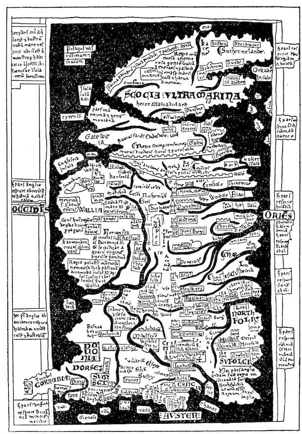
Fig. 9—One of the three maps of Britain by Matthew Paris, that on London Codex Claud. D VI, folio 8 vo. (From Miller, Mappaemundi, vol. iii, 1895, fig. 23).
On one map a legend in the middle informs us that “Britain, 344which includes Scotia, Galloway, and Wales, is now called England.”[1605] Another legend on a different map gives the dimensions (800 miles in length from St. Michael in Cornwall to Caithness, and 300 miles from St. David’s to Dover)[1606] and says that there are two archiepiscopal and thirty-two episcopal sees. The outlines of the coasts are in general admirably shown, especially the west coast, with the westward-reaching promontories of Galloway, Wales, and Cornwall. The east coast is less satisfactory, for neither the indentation of the Wash nor the broad eastward projection of Norfolk appear, and by some confusion a point on the coast of Suffolk is taken as the southeastern corner of Britain, with the result that the Thames is shown as debouching into the English Channel. In the far north, the sketchy outlines of Scotland show that relatively little was known of this remote part of the island. Indeed, on two of the maps the Firths of Clyde and Forth join in such a way as to cut off “Scocia Ultramarina” from the remainder of Britain, with which it is connected by a bridge (see Fig. 9). The courses of the main rivers, Severn, Humber, Avon, Thames, on the whole are well delineated. A large tract in the east is labeled mariscus to designate the Fen country, and the mountains Snowdon, Plynlimon, and Cheviot appear in their correct positions.[1607] The northern Scottish Highlands are described by long legends as mountainous and woody regions which generate an uncultivated and pastoral people, inasmuch as a great part of this area is boggy and full of reeds.[1608] Argyll is a “trackless and watery district well adapted to cattle and pasturage,”[1609] and South Wales is spoken of in much the same terms.[1610] Among the islands off the coast we notice Sheppey, Thanet, Wight, possibly some of the Channel Islands, Portland Head, Scilly, Lundy, Anglesey, Man, Tiree, Iona, and, to the east of Scotland, the Orkneys.[1611] The Hebrides are conspicuously absent, and in their place a legend reads “immense and trackless sea.” A large number of cities are placed more or less in their proper positions, together with the names of counties and other territorial divisions; and finally the Roman walls from Forth to Clyde and from Carlisle to Newcastle make the most prominent feature among the works of man.
345 Orkneys and Shetlands
Returning to Giraldus, we find that among the islands in the neighborhood of Britain he mentions Man, Mona (or Anglesey), the Orkneys, and the Shetlands. Man, he remarks, should be considered as belonging to Britain and not to Ireland. His criterion for so assigning it was the fact that its earth does not resemble the earth of Ireland in the property of killing venomous reptiles.[1612] The Orkneys and Shetlands,[1613] in the northern ocean beyond Ulster and Galloway, were subject to the Norwegian king, through whose piracy and prowess at sea they were held in submission even though geographically they lay nearer the coasts of other countries. Giraldus quotes Orosius and Isidore to the effect that, of the thirty-three Orkneys, thirteen were inhabited and twenty deserted, and he added that in his day, also, the greater part of these isles were uninhabited.
Iceland and Thule
Giraldus writes of Iceland, three days’ sail to the north of Ireland, and gives a few details regarding its people.[1614] The speech of the Icelanders was brief and truthful and they rarely made oath; their king was the equivalent of a priest; and government was in the hands of a bishop. Though thunder and lightning were rare in this distant isle, there was another curse far more terrible: volcanic eruptions and lava flows.