Volume 2 — CHAP. XXV. A NAVAL STUDY—continued.
Reading edition
FRENCH HYDROGRAPHIC CHARTS.—ONE TENDERED BY ME TO THE COURT.—REJECTED BY THE PRESIDENT.—GROUNDS FOR ITS REJECTION.—THE OBJECT OF THE REJECTED CHART.—WOULD HAVE PROVED TOO MUCH, IF ADMITTED.—REJECTION OF OTHER CHARTS TENDERED BY ME.—MR. STOKES’S CHART.—ITS FALLACY AT FIRST SIGHT.—JUDGE ADVOCATE’S REASONS FOR ADOPTING IT.—ITS ERRORS DETECTED BY THE PRESIDENT, AND EXPOSED HERE.—PROBABLE EXCUSE FOR THE ERROR.—IMAGINARY SHOAL ON THE CHART.—FALSIFICATION OF WIDTH OF CHANNEL.—LORD GAMBIER’S VOUCHER FOR STOKES’S CHART.—STOKES’S VOUCHER FOR ITS WORTHLESSNESS.—STOKES’S CHART IN A NATIONAL POINT OF VIEW.—TAKEN ADVANTAGE OF BY THE FRENCH.
The charts to which the reader’s attention is invited are those alluded to in the last chapter, as having, after the lapse of fifty-one years, been traced for me by Captain Washington, by the order of his Grace the Duke of Somerset. The subject being no longer of personal but of historical interest, there can be no impropriety in laying before the naval service, for its judgment, materials so considerately supplied by the present First Lord of the Admiralty.
Chart A
is a correct tracing of Aix Roads from the Neptune François, a set of charts issued by the French Hydrographical Department—bound in a volume, and supplied for the use of the French navy previous to 161809[7]; copies from the same source being at that period supplied under the auspices of the Board of Admiralty for the use of British ships on the French coasts—these, in fact, forming the only guides available at that period.
Chart A shows a clear entrance of two miles, without shoal or hindrance of any kind, between Ile d’Aix and the Boyart Sand; the soundings close to the latter marking thirty-five feet at low water, with from thirty to forty feet in mid-channel. The chart shows, moreover, a channel leading to a spacious anchorage between the Boyart and Palles Sands, marking clear soundings at low water of from twenty to thirty feet close to either sand, with thirty feet in mid-channel. In this anchorage line-of-battle-ships could not only have floated, without danger of grounding, but could have effectively operated against the enemy’s fleet, even in its entire state before the attack, wholly out of range of the batteries on Ile d’Aix, as will hereafter be corroborated by the logs and evidence of experienced officers present in the attack, and therefore practically acquainted with the soundings. To a naval eye, it will be apparent that, by gaining this anchorage, it would not at any time have been difficult for the British force to have interposed the enemy’s fleet between itself and the fortifications on Ile d’Aix in such a way as completely to neutralise the fire of the latter.
Further inspection of the chart will indicate an inner 17anchorage, called Le Grand Trousse, to which any British vessel disabled by the enemy’s ships—two only of which, out of thirteen, remained afloat,—might have retired with safety to an anchorage capable of holding a fleet—the soundings in Le Grand Trousse marking from thirty to forty feet at low water. Between these anchorages it will be seen on the chart that there is no shoal, nor any other danger whatever.[8]
The rise of tide marked on the chart was from ten to twelve feet[9], consequently amply sufficient on a rising tide for the two-deckers and frigates to have been sent to the attack of the enemy’s ships aground on the Palles Shoal, as testified by the evidence of Captains Malcolm and Broughton.[10] The flood-tide making about 7·0 A.M. gave assurance of abundant depth of water by 11·0 A.M., which is the time marked in the Commander-in-chief’s log[11] as that of bringing the British ships to an anchor! in place of forwarding them to the attack of ships on shore!
This chart was tendered by me to the Court, in explanation of my evidence. It was, however, rejected, 18because I could not produce the French hydrographer to prove its correctness! though copies of a similar chart, as has been said, were furnished to British ships for their guidance! Being thus repudiated, my chart was flung contemptuously under the table, and neither this nor any other official chart was afterwards allowed to corroborate the facts subsequently testified by the various officers present in the action, they being imperatively ordered to base their observations on the chart of Mr. Stokes alluded to in the last chapter, as having been—eight years after the court-martial—pronounced by the Court of Admiralty so incorrect as to require material alteration before it could be put in evidence in a court of law! To this point we shall presently come.
A singular circumstance connected with the rejected chart should rather have secured its reception, viz. that it was taken by my own hands out of the Ville de Varsovie French line-of-battle ship shortly before she was set fire to, and therefore its authenticity, as having been officially supplied by the French government for the use of that ship, was beyond doubt or question. I also produced two similar charts, on which were marked the places of the enemy’s ships aground at daylight on the 12th of April, as observed from the Impérieuse, the only vessel then in proximity. The positions of the grounded vessels are marked on Chart B.
The manner of the rejection by the Court—at the suggestion of the Judge-Advocate—of the chart tendered by me, is worthy of note.
President.—“I think your lordship said just now, that you 19thought there was water enough for ships of any draught of water?”
Lord Cochrane.—“Yes.”
President.—“Have you an authenticated chart, or any evidence that can be produced to show that there is actually such a depth of water?”
Lord Cochrane (putting in the charts).—“It was actually from the soundings we had going in, provided the tide does not fall more than twelve feet, which I am not aware of. I studied the chart of Basque Roads for some days before. The rise of the tide, as I understand from that, is from ten to twelve feet. It is so mentioned in the French chart. I have no other means of judging.”[12]
Judge-Advocate.—“This chart is not evidence before the Court, because his lordship cannot prove its correctness!!”
President.—“No! It is nothing more than to show upon what grounds his lordship forms his opinion on the rise and fall of the tide!!”[13]
It was not put in for any purpose of the kind—for I had expressly said that I had no opinion as to the rise and fall of the tide, except as marked on the French official charts. The object of my putting in those charts was to show the truth of the whole matter before the Court. The president, however, flung the chart under the table with as much eagerness as the Judge-Advocate had evinced when objecting to its reception in evidence.[14]
The object of the chart was in fact to prove, as indeed was subsequently proved by the testimony of eminent officers, and would have been proved even by the ships’ logs had they been consulted, that there was plenty of channel room to keep clear of the batteries on Ile d’Aix, together with abundant depth of water[15]; and that the commander-in-chief, in ordering all the ships to come to an anchor, in place of sending a portion[16] of the British 21ships to the attack of the enemy’s vessels aground on the north-west part of the Palles Shoal, on the morning of the 12th of April, had displayed a “mollesse”—as it was happily termed by Admiral Gravière—unbecoming the Commander-in-chief of a British force, superior in numbers, and having nothing to fear from about a dozen guns on the fortifications of Aix; which, had the ships been sent in along the edge of the Boyart, could have inflicted no material damage, either by shot or shell.[17]
These were precisely the points which the ministry did not want proved, and which—as will presently be seen—the Court was no less anxious to avoid proving. Had the French chart been received in evidence, as it ought to have been—I do not say mine, but those on board the flagship itself, or indeed any copy supplied by the Admiralty to the fleet—a vote of thanks to Lord Gambier would have been impossible, and with the impossibility would have vanished the Government prestige of a great victory gained by their commander-in-chief, under their auspices.[18]
The French official chart being thus adroitly got rid of by the Judge-Advocate, the other charts tendered by me to mark the positions of the enemy’s ships 22aground shared the like fate, though not open to the same objection. The exactness of the positions was moreover confirmed by the evidence of Mr. Stokes, the master of the Caledonia, Lord Gambier’s flagship; though his chart, substituted for those in use amongst the British ships, was in direct contradiction to his oral evidence.
The positions, of the ships aground as marked on my charts, were as follows.
The Ocean, three-decker, bearing the flag of Admiral Allemand, and forming a group with three other line-of-battle ships close to her, lay aground on the north-west edge of the Palles Shoal, nearest the deep water, where even a gun-boat, had it been sent whilst they lay on their bilge, could have so perforated their bottoms, that they could not have floated with the rising tide. All were immoveably aground, and were therefore incapable of opposition to an attacking force[19]; whilst each of the 23group of three lay so much inclined towards each other as to present the appearance of having their yards locked together.[20] They had, in fact, drifted with the same current, into the same spot, and being nearly of the same draught of water, had grounded close to each other. The one separate was a vessel of less draught than these, and had gone a little further on the shoal.
The correctness of these positions, as marked on my chart, was completely confirmed by Mr. Stokes, master of the flag-ship, in his oral evidence as subjoined.
Question.—“State the situation of the enemy’s fleet on the morning of the 12th of April.”
Mr. Stokes.—“At daylight I observed the whole of the enemy’s ships, except two of the line, on shore. Four of them lay in group, or lay together on the western part of the Palles Shoal. The three-decker (L’Océan, flagship) was on the north-west edge of the Palles Shoal, with her broadside flanking the passage; the north-west point nearest the deep water.”[20]—(Minutes, page 147.)
This was the truth as to the positions of the grounded ships which escaped; these being referred to in Mr. Stokes’s evidence precisely as marked on my rejected chart. That is, his evidence showed, in corroboration of my chart, the utter helplessness of an enemy which a British admiral refrained from attacking, though aground!
24The French charts produced by me being thus rejected, those in the possession of the Commander-in-chief not produced, and those connected with the fleet not being called for, the court decided to rely upon two charts professedly constructed for the occasion by the master of the Caledonia, Mr. Stokes, and the master of the fleet, Mr. Fairfax, neither of whom was present in the attack.[21]
* * * * * * *
Chart C
was tendered to the Court by Mr. Stokes, the master of Lord Gambier’s flag-ship Caledonia.
CHART C.
Constructed by Mr Stokes for the purposes of the Court Martial, and exclusively adopted, though it narrows the channel to Aix Roads to one mile only, the official French Charts marking two miles.
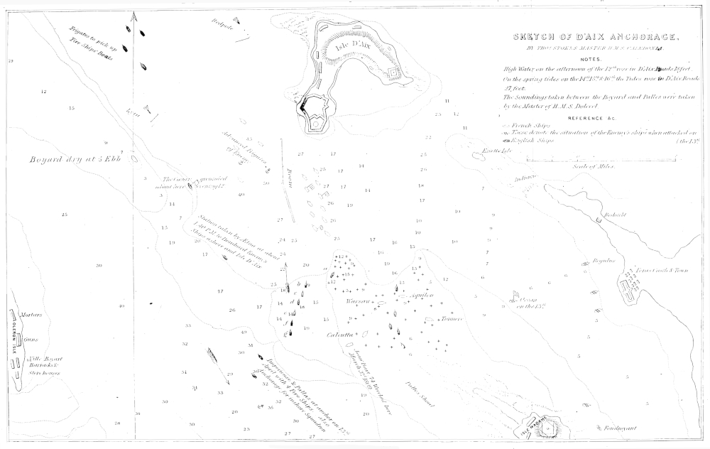
SKETCH OF D’AIX ANCHORAGE. London: Richard Bentley, 1860.
This chart professed to show, and was sworn to by Mr. Stokes as showing, the positions of the enemy’s ships aground on the morning of the 12th of April, before the Ocean three-decker, together with a group of three outermost ships near her, had been permitted by the delay of the Commander-in-chief to warp off and escape. Instead, however, of placing these on his chart as they lay helplessly aground “nearest the deep water” as he had sworn in his evidence, they were placed in 25on the other side of the sand, in the positions occupied after their escape! and to this Mr. Stokes swore as their position when first driven ashore! The Ocean three-decker, and group in particular, which, according to Mr. Stokes’s oral evidence, must, as already stated, have been an easy prey to a gunboat had such been sent on the first quarter instead of the last quarter flood, was thus placed on his chart where no vessel could have approached them![22]
This falsehood on Mr. Stokes’s chart, in opposition to his oral evidence just given, as well as to the evidence of other officers, formed one of the principal grounds of Lord Gambier’s acquittal; and it was for this end that the official French charts presented by me for the information of the court were rejected by the judge-advocate.
On the presentation of Mr. Stokes’s chart to the court, the subjoined colloquy took place as to the methods adopted in its construction.
Mr. Bicknell.—“Produce a chart or drawing of the anchorage at Isle d’Aix, with the relative positions of the 26British and French fleets, and other particulars, on and previous to the 12th of April last.”
The Witness produced it.
Mr. Bicknell.—“Did you prepare this drawing, and from what documents, authorities, and observations; and are the several matters delineated therein accurately delineated, to the best of your knowledge and belief?”
Mr. Stokes.—“I prepared that drawing (Chart C), partly from the knowledge I gained in sounding to the southward of the Palles Shoal, and the anchorage of the Isle of Aix.[23] The outlines of the chart are taken from the Neptune François, and the position of the enemy’s fleet from Mr. Edward Fairfax, and from the French captain of the Ville de Varsovie, and the British fleet from my own observation.” The distance between the sands was copied from a French MS. which will be produced, and that I take it is correct.
Mr. Bicknell.—“Are the matters and things therein accurately described?”
Mr. Stokes.—“They are.”
President (inspecting Mr. Stokes’s chart).—“There was a large chart you lent me?”
27Mr. Stokes.—“That is the chart I allude to. This chart I produce as containing the various positions.”
Judge-Advocate (to the President).—“This Chart is produced to save a great deal of trouble!!” (Minutes, pp. 23, 24.)
No doubt—the trouble of confirming the Commander-in-chief’s neglect of duty in not following up a manifest advantage, as would have been shown had the court allowed the Neptune François itself to have been put, in evidence; for it would have shown a clear passage of two miles wide, extending beyond reach of shot, instead of the one mile passage in Mr. Stokes’s “accurate outlines” of the French chart, and no shoal where he had marked only twelve feet of water![24] That the president should have allowed this to pass, after having himself detected the imposition practised on the court, is a point upon which I will not comment.
Mr. Stokes further admitted his chart to be valueless, as regarded the position of the enemy’s fleet ashore, for he said that position was taken “from Mr. Edward Fairfax and the captain of the Ville de Varsovie”, and the British fleet from “his own observations.” That is, he confessed to know nothing but from hearsay as to the position of the enemy’s fleet, the important object before the court; but only of the position of the British fleet, lying at anchor nine miles from the enemy’s fleet ashore, a matter with which the court had nothing to do; he being all the time on board the flagship, at that distance. Yet the court insisted on this chart being exclusively 28referred to throughout the court-martial![25] It is strange that such a chart should have been used at all, when the charts of the fleet were available, but more strange that, when the court saw the two miles passage in the French chart was reduced to little more than one mile in Mr. Stokes’s chart, he was not even asked the reason why he had not conformed to the scale of the French chart, to the correctness of the outlines of which he had sworn!
But the most glaring contradiction of Mr. Stokes’s chart is this: he swore to his chart as truly depicting the positions of the Ocean and other grounded ships, as they lay on the morning of the 12th of April, which was the point before the Court; but being further questioned, reluctantly admitted that he had marked the Ocean 29as she lay on the 13th of April, viz. on the following day when an attack was made on her by the bomb vessel! though he had just sworn to the positions of the ships on the chart as being those on the morning of the 12th, immediately after having run ashore to escape destruction.
The fact was, as will be seen on inspection of the chart, that not one of the ships under the cognizance of the court is marked on Stokes’s chart as they lay on the morning of the 12th, which position, and not that on the 13th, was the subject of inquiry. Though as already said this misrepresentation was detected by the President, the court nevertheless persisted in the exclusive use of Mr. Stokes’s chart throughout the trial, in accordance with the suggestion of the Judge-Advocate, that it was produced to “save a great deal of trouble.”
The President thus commented on the manifest contradiction.
President.—“I observe in the chart I had from you the situation of the Ocean particularly is not marked on the 12th. She is marked on the 13th as advanced up the Charente!”
Mr. Stokes.—“The only ships marked on the chart on the 12th are those that were destroyed. The reason I marked her on the 13th is, that a particular attack was made on her by the bombs. I observed her from the mizentop of the Caledonia[26], and I also had an observation from an officer, so that I have no doubt her position is put down within a cable’s length.” (Minutes p. 147.)
There is something in this evidence almost too repugnant 30for observation. Mr. Stokes first swore that his chart accurately described the positions of the enemy’s ships ashore on the morning of the 12th. He then admitted that the most material ship of the enemy’s fleet was marked as she lay on the 13th!! On this mis-statement being detected by the president, he then swore that the only ships marked on the 12th were those which were destroyed, viz. on the evening and night of the 12th!—a matter foreign to the subject of inquiry; which was how the ships lay on the morning of the 12th, and whether Lord Gambier was to blame for refraining from attacking them at that particular time? So that the positions of the enemy’s ships aground on the morning of the 12th, according to Mr. Stokes’s own admission, were not marked on his chart at all! though he had sworn to this very chart as giving those positions accurately to the best of his knowledge and belief; and with the full knowledge that their position on the morning of the 12th, when they were helplessly aground, was the point before the court,—not their position in the evening, and on the following day after their escape to a spot where the British ships could not have pursued them.
The fact is, Mr. Stokes swore to their positions after their being warped off in consequence of the British fleet being prematurely brought to an anchor—as being their positions previous to their escape! which was the matter of inquiry before the court, viz. as to whether the Commander-in-chief had not committed a neglect of duty in permitting them to escape by the rising tide, when and before when the British force could have operated with every advantage in its favour. 31The court had nothing whatever to inquire about with regard to the ships which were destroyed, respecting which there could be no question; the subject of inquiry being whether the escape of the other ships run ashore from terror of the explosion vessels on the night of the 11th, and still ashore on the morning of the 12th, ought to have been prevented.
Not so much as one of the ships marked on Mr. Stokes’s chart formed part of the “group” to which he had sworn, in his oral evidence, as lying on the “western and northernmost edge of the Palles Shoal, nearest the deep waterwater, all of which escaped towards the Charente, where he truly enough placed the Ocean three-decker, but as she lay on the 13th instead of the 12th, he having sworn to the truth of his chart as showing her position on the morning of the 12th! It was a desperate venture, and can only be accounted for by the supposition that, in reality, Mr. Stokes had never seen the chart to which he was swearing. It was no wonder, as proved in the first chapter, that Mr. Stokes applied to the Admiralty for permission to alter his chart before producing it in a court of law, where it must have fallen under my inspection!
I will indeed so far exonerate Mr. Stokes from a portion of blame, by declaring my belief that he never had looked at the chart to which he had sworn. There is little question in my mind but that this chart had been fabricated under the auspices of Mr. Lavie, Lord Gambier’s solicitor, the only hope of success consisting in affirming a false position for the grounded ships; the chart being then given to Stokes for paternity. Had it been otherwise, Stokes could not possibly have 32sworn to a chart in diametrical opposition to his oral evidence, which truly stated that on the morning of the 12th, the Ocean and group lay on “the north-west edge of the Palles shoal, nearest the deep water,” where they were easily attackable. On his chart they were placed on the opposite side of the shoal! where no ship could have got near them.
Lord Gambier no doubt saw the mistake committed by the evidence of his Master, and adroitly relieved him from the dilemma, by putting a question of a totally different nature. With this course the court complacently complied, notwithstanding that the president had detected a discrepancy so glaring.
Another material point on Mr. Stokes’s chart was his marking a shoal between the Boyart and the Palles Sands, where Capt. Broughton and others present in the action, who actually sounded there, testify in corroboration of the French chart to there being no shoal whatever.[27] Yet Mr. Stokes marks only from twelve to sixteen feet, in the deepest part. That this statement was a misrepresentation on the part of Mr. Stokes, is proved by Lord Gambier himself, who, in his defence, says that “Mr. Stokes found on this bar or bank from fourteen to nineteen feet”feet” (Minutes, p. 134). When closely questioned on the point, Mr. Stokes deposed to these soundings as “having been reported to him to have been found”! (Minutes, p. 150.) The Neptune François gives from twenty to thirty feet at low water, which was no doubt correct.
But even had there been only nineteen feet of water Mr. Stokes again forgot his chart when he gave oral 33evidence that “the rise of tide in Aix Roads is twenty-one feet, which is more than we ever found in Basque Roads” (Minutes, p. 150). I had put the rise of tide at twelve feet only, so that by the oral evidence of Mr. Stokes there was abundance of water for the British force to have operated with full effect.
A still further falsification of the chart was, that it reduced the channel by which the British fleet must have passed to the attack to little more than a mile in width, in defiance of the fact that on all the official French charts the minimum distance between the Boyart Sand and the fortifications on Ile d’Aix was nearly two miles, and that Admiral Stopford, the second admiral in command, confirmed the correctness of the French charts so far as to admit a width of a mile and a half. The object of Mr. Stokes’s statement was to prove the danger to which, in a channel only a mile wide, the British ships would have been exposed from the batteries on Ile d’Aix had they been sent to the attack. To this end was the chart no doubt produced, and as narrowing the channel to a mile only—to meet the occasion—gave a colour to this view, his chart was accepted by the court, whilst the French charts which marked two miles, were rejected.
A yet more flagrant contradiction is—that within pistol shot of the western and north-western edge of the Palles Shoal, where Mr. Stokes first truly swore “the Ocean three-decker and a group of four lay aground on the morning of the 12th,” he has placed the attacking British ships, where their logs show that they never touched the ground, notwithstanding that they took up 34their positions on a falling tide. If they could float in safety much more could other ships have done so at 11 a.ma.m on a rising tide? How such a manifest discrepancy could have passed without comment from any member of the court-martial, is a point which is not in my power to explain.
Such are some of the leading features of this famous chart, upon which the acquittal of Lord Gambier was made to rest, though the chart was admittedly constructed—not from personal observation, otherwise than from the mizentop of the Caledonia, nine miles off—but from unofficial sources—from an anonymous manuscript, and even from hearsay!
Yet Lord Gambier did not scruple to introduce this chart for the guidance of the court, in the following terms:
“I have to call the attention of the Court to the plan drawn by Lord Cochrane of the position of the enemy’s ships as they lay aground on the morning of the 12th of April, and to that position marked upon the chart verified by Mr. Stokes; the former laid down from uncertain data, the latter from angles measured and other observations made on the spot[28]; the difference between the two is too apparent to escape the notice of the Court, and the respective merits of these charts will not, I think, admit of a comparison.” (Minutes, p. 133.)
This statement was made by Lord Gambier in face of the admission previously made by Mr. Stokes, that his observations were taken from the mizentop of the Caledonia, three leagues off—that he had never 35sounded in Aix Roads—that the soundings were only reported to him, the name of the reporter being omitted—and that he had only marked upon his chart, “the ships that were destroyed” on the evening and during the night of the 12th, the destruction, in fact, not being complete till the morning of the 13th.
This contradiction is so important to a right comprehension of what follows, that I will, at the risk of prolixity, bring into one focus Mr. Stokes’s admissions as to his data for the construction of his chart.
“I prepared that drawing partly from the knowledge I gained in sounding to the southward of the Palles Shoal. The outlines of the chart are taken from the Neptune François (narrowed from two miles to one!). The positions of the enemy’s fleet are from Mr. Fairfax and the captain of the Ville de Varsovie. For the distance between the sands I must refer the court to a chart which I copied from a French manuscript!” (Minutes, pp. 23, 24.)
For this confused jumble from unauthoritative sources, the French charts were rejected as not being trustworthy, and Lord Gambier did not hesitate to endorse Mr. Stokes’s fabrication as being “from angles measured and other observations taken on the spot;” whilst by this act he decried the use of the French charts by which his own fleet had been guided!
Comment, whether on Lord Gambier’s statement or on Mr. Stokes’s involuntary contradiction thereof in his oral evidence, is superfluous. If such were wanted, it must be sought for in the fact already adduced in the first chapter, viz. that, in 1817 and 1818, Mr. Stokes, when conscious that his fabrication must become public, and that it might fall into my 36hands, thought it prudent to make affidavit before the Court of Admiralty that this chart, produced at the court-martial nine years before, was incorrect, and therefore required alteration!! for which purpose the Admiralty gave him back his chart, though this, as already observed, remains to this day bound up amongst the Admiralty records. The affidavits of Mr. Stokes will be in the remembrance of the reader.
In a national point of view, Mr. Stokes’s chart has another and even more important feature. A comparison between the French chart and that produced by Mr. Stokes will show that the latter narrowed the entrance to Aix Roads—which on the French charts is two miles wide—to one mile, and that it filled a space with shoals where scarcely a shoal existed. Of the imaginativeness of Mr. Stokes in this respect, the French Government appears to have taken a very justifiable naval advantage, calculated to deter any British admiral in future from undertaking in Aix Roads offensive operations of any kind.
A chart of the Aix Roads based on a modern French chart has recently been shown me, as on the point of being issued by the Board of Admiralty, on which chart the main channel between Ile d’Aix and the Boyart sand is laid down according to charts copied from fabricated charts produced on Lord Gambier’s court-martial, and not according to the hydrographic charts of the Neptune François. The comparatively clear anchorage shown in the new chart is also filled with Mr. Stokes’s imaginary shoals! the result being that no British admiral, if guided by the new chart, 37would trust his ships in Aix Roads at all, though both under Admiral Knowles and at the attack in 1809 British ships found no difficulty whatever from want of water, or other causes, when once ordered in.
CHART D.
Constructed by Mr Fairfax and produced for the guidance of the Court Martial. Like Stokes’s Chart, it narrows the channel to Aix Roads from two miles to one mile though also like him professing to be an exact outline of the French Official Chart.]
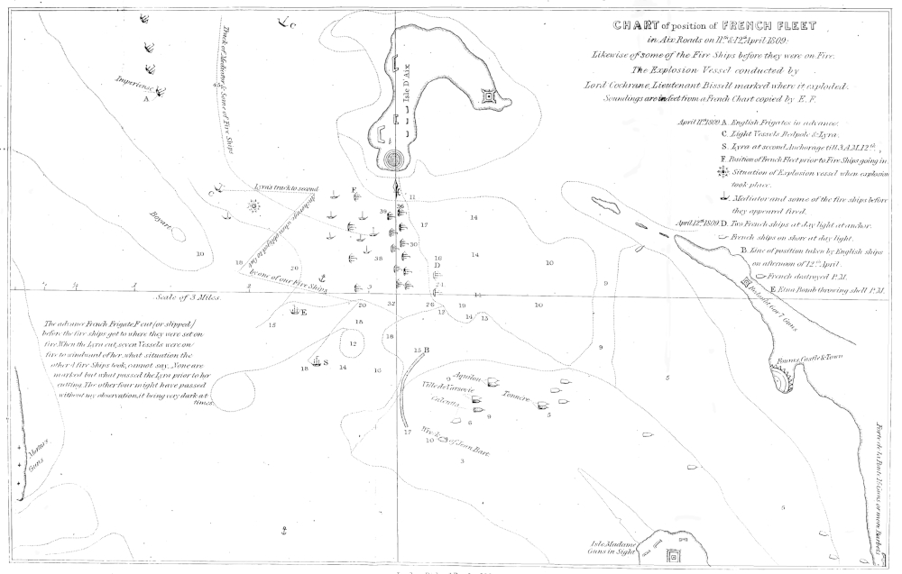
London Richard Bentley, 1860
The solution of the matter is not difficult. For the purpose of deterring a future British fleet from entering Aix Roads, the modern French Government appears to have followed the chart of Mr. Stokes in place of their former official chart; and the British Admiralty, having no opportunity of surveying the anchorage in question, has copied this modern French chart; so that in future the fabrications of Mr. Stokes or rather I should say, the ingenuity of Lord Gambier’s solicitor, or whoever may have palmed the chart on Mr. Stokes, will form the best possible security to one of the most exposed anchorages on the Atlantic coast of France. Assuredly no British Admiral, with the new chart in his hands,—should such be issued—would for a moment think of operating in such an anchorage as is there laid down, notwithstanding that former British fleets have operated in perfect safety so far as soundings were concerned.
Chart D
was constructed by Mr. Fairfax, the Master of the Fleet, and was used by the Court as confirmatory of Mr. Stokes’s chart, agreeing with it, in fact, on nearly every point; a circumstance not at all extraordinary, as in his examination Mr. Stokes first says that “his marks arose from the knowledge he gained in sounding in the anchorage of Aix” (Minutes, 38p. 23), whilst Mr. Fairfax swore that he “gave Mr. Stokes the marks.”!![29] A fact subsequently proved by Mr. Stokes, who admitted that he had “never sounded there at all.all.” The credibility of either witness may be left to the reader’s judgment.
In one respect, the chart of Mr. Fairfax might have been considered by those interested to be an improvement on that of Mr. Stokes. The latter gentleman had narrowed the two mile channel of the French charts to a little more than a mile, but the chart of Mr. Fairfax reduces it to a mile only!
Mr. Fairfax’s chart was introduced to the Court with the same flourish as had been that of Mr. Stokes.
Mr. Fairfax.—“This chart shows the state of the enemy’s ships at daylight on the 12th of April. This chart is correct, except that the head of the Calcutta is placed by the engraver too far to the southward. It should have been about N.W. by compass, and the head of the three decker Ocean is to the eastward, but not sufficiently far to the northward by compass.”
Not much correctness here, but abundance of misrepresentation. Mr. Fairfax is very particular about the positions of the heads of the grounded ships, but, like Mr. Stokes, not at all particular to a league or two as to where they lay aground. For instance, he is very sensitive about the position of the Ocean’s head, yet the Ocean herself is not to be found on his chart!! 39though the names of other enemy’s ships aground, not far from where she had lain before her escape, are given, to mark the care with which the chart had been constructed!
I will not in this place make any further observations upon Mr. Fairfax’s chart, this being identical with that of Mr. Stokes. The exposure of the one in the next chapter will serve for the confutation of the other. The reader will, from what has been stated, be able to form a pretty correct idea as to why—in, and subsequently to 1809—inspection of these charts was refused to me. At that period it was in vain that I published explanations, which, without access to the charts, were incomprehensible to the public; my unsupported declarations, as has been said, falling to the ground unheeded, even if they were not the cause of attributing to me malicious motives towards the commander-in-chief, after his acquittal by sentence of a court-martial. But for the consideration of his Grace the Duke of Somerset a stigma must have followed me to the grave. It is now otherwise, and I am content to leave the matter to the judgment of posterity. I must, however, remark, that neither the charts of Mr. Stokes or Mr. Fairfax were shown to me on the court-martial, though shown to nearly every other witness, one—Capt. Beresford—being told that he “must” base his observations on those charts. Had they been shown to me, I should in an instant have detected their fallacy.
40