VOLUME XVII SLICE V Malta to Map, Walter (continued 4)
Reading edition
Arms.—There has been much controversy about the origin of the arms of the island—the “three-legs” found on a beautiful pillar cross near Maughhold churchyard belonging to the latter part of the 14th century. It was probably originally a sun symbol and was brought from Sicily by the Vikings. The motto quocunque jeceris slabit is of comparatively recent origin.
Bibliography.—History and Law: The Manx Society’s publications, vols. i.-xxxii., notably the Chronicon Manniae (vols. xxii. and xxiii., edited by Munch); Sir Spencer Walpole, K.C.B., The Land of Home Rule, an essay on the history and constitution of the Isle of Man (London, Longmans, Green & Co., 1893); A. W. Moore, M.A., C.V.O., The Diocese of Sodor and Man, S.P.C.K.’s series of Diocesan Histories (1893); and A History of the Isle of Man, (2 vols., London, T. Fisher Unwin, 1900); The Statutes of the Isle of Man from 1817 to 1895, Gill’s edition, 6 vols. (vol. i. 1883 to vol. vi. 1897, London, Eyre & Spottiswoode); Richard Sherward (Deemster), Manx Law Tenures, a short treatise on the law relating to real estate in the Isle of Man (Douglas Robinson Bros., 1899). Archaeology and Folklore: P. M. C. Kermode, F. S. A. Scot., Manx Crosses (London, Bemrose & Sons, 1907); E. Alfred Jones, The Old Church Plate of the Isle of Man (Bemrose & Sons, 1907); A. W. Moore, C.V.O., M.A., The Folklore of the Isle of Man (London, D. Nutt, 1891). Language and Philology: A Dictionary of the Manx Language (Manx-English), by Archibald Cregeen (1835); A Practical Grammar of the Antient Gaelic, or Language of the Isle of Man, usually called Manks, by Rev. John Kelly, LL.D.; Manx Society’s publications, vol. ii. (1859, reprint of edition of 1804); The Manx Dictionary in two ports (Manx-English, English-Manx), by Rev. John Kelly, William Gill and John Clarke; Manx Society’s publications, vol. xiii. (1866); The Book of Common Prayer in Manx Gaelic, being translations made by Bishop Phillips in 1610 and by the Manx clergy in 1765, edited by A. W. Moore, C.V.O., M.A., and John Rhys, M.A., LL.D.; Outlines of the Phonology of Manx Gaelic, by John Rhys (Oxford University Press, 2 vols., 1893-1894); First Lessons in Manx, by Edmund Goodwin (Dublin, Celtic Association, 1901); Manx National Songs, with English words, from the MS. collection of the Deemster Gill, Dr J. Clague and W. H. Gill, and arranged by W. H. Gill (London, Boosey & Co., 1896); Manx Ballads and Music, edited by A. W. Moore (Douglas, G. and R. Johnson, 1896); A. W. Moore’s The Surnames and Place Names of the Isle of Man (London, Elliot Stock, 1906, 3rd ed.). Natural History: P. G. Ralfe, The Birds of the Isle of Man (Edinburgh, David Douglas, 1905).
Hall Caine’s novels, The Deemster, The Manxman, &c., have no doubt tended to popularize the island. The most truthful description of the social life of the people is to be found in a novel entitled The Captain of the Parish, by John Quine. Bibliotheca Monensis (Manx Society, vol. xxiv.) contains a good list of MSS. and books relating to the island up to 1876, and A. W. Moore’s History of the Isle of Man has a list of the most important MSS. and books up to 1900.
(A. W. M.)
1 G. W. Lamplough, The Geology of the Isle of Man, Mem. Geol. Survey (1903).

MANAAR, GULF OF, a portion of the Indian Ocean lying between the coast of Madras and Ceylon. Its northern limit is the line of rocks and islands called Adam’s Bridge. Its extreme width from Cape Comorin to Point de Galle is about 200 miles.
MANACOR, a town of Spain in the island of Majorca, 40 m. by rail E. of Palma. Pop. (1900), 12,408. Manacor has a small trade in grain, fruit, wine, oil and live stock. In the neighbourhood are the cave of Drach, containing several underground lakes, and the caves of Artá, one of the largest and finest groups of stalactite caverns in western Europe.
MANAGE, to control, direct, or be in a position or have the capacity to do anything (from Ital. maneggiare, to train horses, literally to handle; Lat. manus, hand). The word was first used of the “management” of a horse. Its meanings have been much influenced by the French ménager, to direct a household or ménage (from late Lat. mansio, house); hence to economize, to husband resources, &c. The French ménage, act of guiding or leading, from mener, to lead, seems also to have influenced the meaning.
MANAGUA, the capital of Nicaragua, and of the department of Managua; on the southern shore of Lake Managua, and on the railway from Diriamba to El Viejo, 65 m. by rail S.E. of the Pacific port of Corinto. Pop. (1905), about 30,000. Managua is a modern city, with many flourishing industries and a rapidly growing population. Its chief buildings are those erected after 1855, when it was chosen as the capital to put an end to the rivalry between the then more important cities of Leon and Granada. They include the Palacio Nacional or government buildings, Corinthian in style, the national library and museum, an ornate Renaissance structure, the barracks and the general post office. Owing to its position on the lake, and its excellent communications by rail and steamer, Managua obtained after 1855 an important export trade in coffee, sugar, cocoa and cotton, although in 1876 it was temporarily ruined by a great inundation.
MANAKIN, from the Dutch word Manneken, applied to certain small birds, a name apparently introduced into English by G. Edwards (Nat. Hist. Birds, i. 21) in or about 1743, since which time it has been accepted generally, and is now used for those which form the family Pipridae. The manakins are peculiar to the Neotropical Region and have many of the habits of the titmouse family (Paridae), living in deep forests, associating in small bands, and keeping continually in motion, but feeding almost wholly on the large soft berries of the different kinds of Melastoma. The Pipridae, however, have no close affinity with the Paridae,1 but belong to another great division of the order Passeres, the Clamatores group of the Anisomyodae. The manakins are nearly all birds of gay appearance, generally exhibiting rich tints of blue, crimson, scarlet, orange or yellow in combination with chestnut, deep black, black and white, or olive green; and among their most obvious characteristics are their short bill and feeble feet, of which the outer toe is united to the middle toe for a good part of its length. The tail, in most species very short, has in others the middle feathers much elongated, and in one of the outer rectrices are attenuated and produced into threads. They have been divided (Brit. Mus. Cat. Birds, vol. xiv.) into nineteen genera with about seventy species, of which eighteen are included under Pipra itself. P. leucilla, one of the best known, has a wide distribution from the isthmus of Panama to Guiana and the valley of the Amazon; but it is one of the most plainly coloured of the family, being black with a white head. The genus Machaeropterus, consisting of four species, is very remarkable for the extraordinary form of some of the secondary wing-feathers in the males, in which the shaft is thickened and the webs changed in shape, as described and illustrated by P. L. Sclater (Proc. Zool. Society, 1860, p. 90; Ibis, 1862, p. 1752) in the case of the beautiful M. deliciosus, and it has been observed that the wing-bones of these birds are also much thickened, no doubt in correlation with this abnormal structure. A like deviation from the ordinary character is found in the allied genus Chiromachaeris, comprehending seven species, and Sclater is of the opinion that it enables them to make the singular noise for which they have long been noted, described by O. Salvin (Ibis, 1860, p. 37) in the case of one of them, M. candaei, as beginning “with a sharp note not unlike the crack of a whip,” which is “followed by a rattling sound not unlike the call of a landrail”; and it is a similar habit that has obtained for another species, M. edwardsi, the name in Cayenne, according to Buffon (Hist. Nat. Oiseaux, iv. 413), of Cassenoisette.
(A. N.)
1 Though Edwards called the species he figured (ut supra) a titmouse, he properly remarked that there was no genus of European birds to which he could liken it.
2 The figures are repeated by Darwin (Descent of Man, &c., ii. 66).
MANAOAG, a town in the north central part of the province of Pangasinán, Luzon, Philippine Islands, on the Angalacan river, 21 m. N.E. of Lingayen. Pop. (1903), 16,793. The inhabitants devote themselves especially to rice-culture, though tobacco, Indian corn, sugar-cane, fruit and vegetables are also raised. A statue of the Virgin Mary here is visited annually (especially during May) by thousands from Pangasinán and adjoining provinces. The inhabitants are mostly Ilocanos. Manaoag includes the town proper and eighteen barrios.
MANÁOS, a city and port of Brazil and capital of the state of Amazonas, on the left bank of the Rio Negro 12 m. above its junction with the Solimões, or Amazon, and 908 m. (Wappäus) above the mouth of the latter, in lat. 3° 8′ 4″ S., long. 60° W. Pop. (1908), about 40,000, including a large percentage of Indians, negroes and mixed-bloods; the city is growing rapidly. Manáos stands on a slight eminence overlooking the river, 106 ft. above sea-level, traversed by several “igarapés” (canoe paths) or side channels, and beautified by the luxuriant vegetation of the Amazon valley. The climate is agreeable and healthful, the average temperature for the year (1902) being 84°, the number of rainy days 130, and the total rainfall 66.4 in. Up to the beginning of the 20th century the only noteworthy public edifices were the church of N.S. da Conceição, the St Sebastião asylum and, possibly, a Misericordia hospital; but a government building, a custom-house, a municipal hall, courts of justice, a marketplace and a handsome theatre were subsequently erected, and a modern water-supply system, electric light and electric tramways were provided. The “igarapés” are spanned by a number of bridges. Higher education is provided by a lyceum or high school, besides which there is a noteworthy school (bearing the name of Benjamin Constant) for poor orphan girls. Manáos has a famous botanical garden, an interesting museum, a public library, and a meteorological observatory. The port of Manáos, which is the commercial centre of the whole upper Amazon region, was nothing but a river anchorage before 1902. In that year a foreign corporation began improvements, which include a stone river-wall or quay, storehouses for merchandise, and floating wharves or landing stages connected with the quay by floating bridges or roadways. The floating wharves and bridges are made necessary by the rise and fall of the river, the difference between the maximum and minimum levels being about 33 ft.
The principal exports are rubber, nuts, cacao, dried fish, hides and piassava fibre. The markets of Manáos receive their supplies of beef from the national stock ranges on the Rio Branco, and it is from this region that hides and horns are received for export. The shipping movement of the port has become large and important, the total arrivals in 1907, including small trading boats, being 1589, of which 133 were ocean-going steamers from Europe and the United States, 75 from south Brazilian ports, and 227 river steamers from Pará. This rapid growth in its direct trade is due to a provincial law of 1878 which authorized an abatement of 3% in the export duties on direct shipments, and a state law of 1900 which made it compulsory to land and ship all products of the state from the Manáos custom-house.
The first European settlement on the site of Manáos was made in 1660, when a small fort was built here by Francisco da Motta Falcão, and was named São José de Rio Negro. The mission and village which followed was called Villa de Barra, or Barra do Rio Negro (the name “Barra” being derived from the “bar” in the current of the river, occasioned by the setback caused by its encounter with the Amazon). It succeeded Barcellos as the capital of the old capitania of Rio Negro in 1809, and became the capital of Amazonas when that province was created in 1850, its name being then changed to Manáos, the name of the principal tribe of Indians living on the Rio Negro at the time of its discovery. In 1892 Manáos became the see of the new bishopric of Amazonas.
MANASSAS, a district of Prince William county, Virginia, and a town of the district, about 30 m. W.S.W. of Washington, D.C. Pop. (1910) of the district, 3381; of the town, 1217. The village of Manassas (in the town), known also as Manassas Junction, is served by the Chesapeake & Ohio and the Southern railways. North of the junction is Bull Run, a small stream which empties into the Occoquan, an arm of the Potomac. In this neighbourhood two important battles of the American Civil War, the first and second battles of Bull Run, were fought on the 21st of July 1861 and on the 29th-30th of August 1862 respectively; by Southern historians these battles are called the battles of Manassas. At Manassas is the Manassas Industrial School for Coloured Youth (non-sectarian; privately supported), which was founded in 1892 and opened in 1894; in 1908-1909 it had nine teachers (all negroes) and 121 pupils, all in elementary grades.
MANASSEH (7th cent. B.C.), son of Hezekiah, and king of Judah (2 Kings xxi. 1-18). His reign of fifty-five years was marked by a reaction against the reforming policy of his father, and his persistent idolatry and bloodshed were subsequently regarded as the cause of the destruction of Jerusalem and of the dispersion of the people (2 Kings xxiii. 26 seq.; Jer. xv. 4). As a vassal of Assyria he was contemporary with Sennacherib, Esar-haddon (681-668 B.C.) and Assur-bani-pal (668-626 B.C.), and his name (Me-na-si-e) appears among the tributaries of the two latter. Little is known of his history. The chronicler, however, relates that the Assyrian army took him in chains to Babylon, and that after his repentance he returned, and distinguished himself by his piety, by building operations in Jerusalem and by military organization (2 Chron. xxxiii. 10 sqq.). The story of his penitence referred to in xxxiii. 22, is untrustworthy, but the historical foundation may have been some share in the revolt of the Babylonian Samas-sum-ukin (648 B.C.), on which occasion he may have been summoned before Assur-bani-pal with other rebels and subsequently reinstated. See further Driver, in Hogarth, Authority and Archaeology, pp. 114 sqq. Manasseh was succeeded by his son Amon, who after a brief reign of two years perished in a conspiracy, his place being taken by Amon’s son (or brother) Josiah (q.v.). A lament formerly ascribed to Manasseh (cf. 2 Chron. xxxiii. 18) is preserved in the Apocrypha (see Manasses, Prayer of; and Apocryphal Literature). On Judg. xviii. 30 (marg.), see Jonathan.
MANASSEH (apparently Hebrew for “he who causes to forget,” but see H. W. Hogg, Encyc. Bib., s.v.); in the Bible, a tribe of Israel, the elder but less important of the “sons” of Joseph. Its seat lay to the north of Ephraim, but its boundaries can scarcely be defined. It merged itself with its “brother” in the south, and with Issachar, Zebulun and other tribes in the north (Josh. xvii. 7 sqq.). From the latter it was separated for a time by a line of Canaanite cities extending from Dor to Bethshean, which apparently were not all subdued till the days of David or Solomon (Judg. i. 27; 1 Sam. xxxi. 10; 1 Kings ix. 15). Besides its western settlement in the fertile glades of northern Samaria, running out into the great plain, there were territories east of the Jordan reckoned to Manasseh. Gilead and Bashan were said to have been taken by Machir, and a number of places of uncertain identification were occupied by Nobah and Jair (Num. xxxii. 41; Judg. x. 3-5). It seems most natural to suppose that these districts were held before the Israelites crossed over to the west (cf. the tradition Num. xxi., Deut. iii.). On the other hand, in Judg. v. 14, Machir may conceivably belong to the west, and it is possible that, according to another tradition, these movements were the result of the complaint of the Joseph tribes that their original territory was too restricted.1 In the genealogical lists, Machir, perhaps originally an independent branch, is the eldest son of Manasseh (Josh. xvii. 1 b, 2); but according to later schemes he is Manasseh’s only son (Num. xxvi. 28-34). Intermixture with Arameans is indicated in the view that he was the son of Manasseh and an Aramean concubine (1 Chron. vii. 14), and this is supported by the statement that the Arameans of Geshur and Maacah (cf. 2 Sam. x. 6; Gen. xxii. 24) dwelt among the Israelites of eastern Jordan (Josh. xiii. 13). Subsequently, at an unknown period of history, sixty cities were lost (1 Chron. ii. 23). The story of the daughters of the Manassite Zelophehad is of interest for the Hebrew law of inheritance (Num. xxvii. 1-11, xxxvi.).
Some details of the history of this twofold branch of the Israelites are contained in the stories of Gideon (W. Manasseh) and Jephthah (E. Manasseh). The relations between Saul and Jabesh-Gilead point to the close bond uniting the two districts, but the details have been variously interpreted: Winckler, for example, suggesting that Saul himself was originally from E. Manasseh and that he followed in the steps of Jephthah (Keilinschr. u. d. alte Test., pp. 216 seq. 227). Generally speaking, its position in the west made it share the fortunes of Ephraim, whilst on the east the proximity of Ammonites and Moabites controlled its history; see also the articles on its southern neighbours, Gad and Reuben, and the articles Genealogy (Biblical); and Jews: History.
(S. A. C.)
1 So Budde (Richter u. Samuel), who recovers certain old fragments and arranges Josh. xvii. 14-18 (v. 18 read “hill-country of Gilead”); Num. xxxii. 39, 41 seq.; Josh. xiii. 13.
MANASSES, CONSTANTINE, Byzantine chronicler, flourished in the 12th century during the reign of Manuel I. (Comnenus) (1143-1180). He was the author of a Chronicle or historical synopsis of events from the creation of the world to the end of the reign of Nicephorus Botaniates (1081), written by direction of Irene, the emperor’s sister-in-law. It consists of about 7000 lines in the so-called “political” metre.1 There is little to be said of it, except that it is rather more poetical than the iambic chronicle of Ephraim (about 150 years later). It obtained great popularity and appeared in a free prose translation; it was also translated into Slavonic. The poetical romance of the Loves of Aristander and Callithea, also in “political” verse, is only known from the fragments preserved in the Ῥοδωνία (rose-garden) of Macarius Chrysocephalus (14th century). Manasses also wrote a short biography of Oppian, and some descriptive pieces (all except one unpublished) on artistic and other subjects.
Editions.—Chronicle in Bonn, Corpus scriptorum hist. Byz., 1st ed. Bekker (1837) and in J. P. Migne, Patrologia graeca, cxxvii.; Aristander and Callithea in R. Hercher’s Scriptores erotici graeci, ii. (1859); “Life of Oppian” in A. Westermann, Vitarum scriptores graeci minores (1845). A long didactic poem in “political” verse (edited by E. Miller in Annuaire de l’assoc. pour l’encouragement des études grecques en France, ix. 1875) is attributed to Manasses or one of his imitators. See also F. Hirsch, Byzantinische Studien (1876); C. Krumbacher, Geschichte der byzantinischen Litteratur (1897).
1 “Political” verse or metre is the name given to a kind of verse found as early as the 6th century in proverbs, and characteristic of Byzantine and modern Greek poetry. It takes no account of the quantity of syllables; the scansion depends on accent, and there is always an accent on the last syllable but one. It is specially used of an iambic verse with fifteen syllables, i.e. seven feet and an unaccented syllable over. Byron compares “A captain bold of Halifax who lived in country quarters.” Such facile metres are called “political,” in the sense of “commonplace,” “of the city.” Cf. Gibbon’s Decline and Fall (ed. Bury, 1898), vi. 108; Du Cange, Gloss. med. et infin. lat. (vi. 395), who has an interesting quotation from Leo Allatius. Leo explains “political” as implying that the verses are “scorta et meretrices, quod omnibus sunt obsequiosae et peculiares, et servitutem publicam serviunt.”
MANASSES, PRAYER OF, an apocryphal book of the Old Testament. This writing, which since the Council of Trent has been relegated by the Church of Rome to the position of an appendix to the Vulgate, was placed by Luther and the translators of the English Bible among the apocryphal books. In some MSS. of the Septuagint it is the eighth among the canticles appended to the Psalter, though in many Greek psalters, which include the canticles, it is not found at all. In Swete’s Old Testament in Greek, iii. 802 sqq., A is printed with the variants of T (Psalterium turicense).1 From the statements in 2 Chron. xxxiii. 12, 13, 18, 19, it follows that the Old Testament chronicler found a prayer attributed to Manasseh in his Hebrew sources, The History of the Kings of Israel and The History of the Seers. Naturally the question arose, had the existing Prayer of Manasses any direct connexion with the prayer referred to by the chronicler? Ewald was of opinion that the Greek was an actual translation of the lost Hebrew; but Ball more wisely takes it as a free rendering of a lost Haggadic narrative founded on the older document from which the chronicler drew his information. This view he supports by showing that there was once a considerable literature in circulation regarding Manasseh’s later history. On the other hand most scholars take the Prayer to have been written in Greek, e.g. Fritzsche, Schürer and Ryssel (Kautzsch, Apok. u. Pseud. i. 165-168).
This fine penitential prayer seems to have been modelled after the penitential psalms. It exhibits considerable unity of thought, and the style is, in the main, dignified and simple.
As regards the date, Fritzsche, Ball and Ryssel agree in assigning this psalm to the Maccabean period. Its eschatology and doctrine of “divine forgiveness” may point to an earlier date.
The best short account of the book is given by Ball (Speaker’s Apocrypha, ii. 361-371); see also Porter in Hastings’s Dict. Bible, iii. 232-233.
(R. H. C.)
1 Nestle (Septuaginta Studien III.) contends that the text of A and T is derived from the Apost. Const. ii. 22, or from its original, and not from a MS. of the Septuagint.
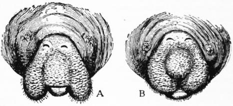
MANATI (often anglicized as “manatee”), the name, adapted from the Carib manattouï, given by the Spanish colonists of the West Indies to the American representative of a small group of herbivorous aquatic mammals, constituting, with their allies the dugong and the now extinct Rhytina, the order Sirenia. The name, though possibly of Mandingo origin (see Mandingo), was latinized as manatus, furnished with hands, thus referring the etymology to the somewhat hand-like form, or hand-like use, of the fore-flippers, which alone serve these creatures for limbs. Manatis, as shown in the illustration in the article Sirenia, are somewhat whale-like in shape, having a similar horizontally expanded tail-fin; but here the resemblance to the Cetacea ceases, the whole organization of these animals being constructed on entirely different lines. The American manati, Manatus (or, as some would have it, Trichechus latirostris), inhabits the rivers of Florida, Mexico, Central America and the West Indies, and measures from 9 to 13 feet in length. The body is somewhat fish-like, but depressed and ending posteriorly in a broad, flat, shovel-like horizontal tail, with rounded edges. The head is of moderate size, oblong, with a blunt, truncated muzzle, and divided from the body by a slight constriction or neck. The fore limbs are flattened oval paddles, placed rather low on the sides of the body, and showing externally no signs of division into fingers, but with three diminutive flat nails near their extremities. No traces of hind limbs are discernible either externally or internally; and there is no dorsal fin. The mouth is peculiar, the tumid upper lip being cleft in the middle line into two lobes, each of which is separately movable. The nostrils are two semilunar valve-like slits at the apex of the muzzle. The eyes are very minute, placed at the sides of the head, and with a nearly circular aperture with wrinkled margins; and external ears are wanting. The skin generally is of a dark greyish colour, not smooth or glistening like that of whale or dolphin, but finely wrinkled. At a little distance it appears naked, but close inspection, at all events in young animals, shows a scanty covering of delicate hairs, and both upper and under lips are supplied with short, stiff bristles.
(From Murie.)
Front view of head of American Manati, showing the eyes, nostrils, and mouth. A, with the lobes of the upper lip divaricated; B, with the lip contracted.
Manatis have a number—as many as 20 pairs in each jaw—of two-ridged teeth, of which, however, but comparatively few are in use at once. They lack the large tusks of the male dugong, and the fore part of the skull is not so much bent down as in that animal. In life the palate has a horny plate, with a similar one in the lower jaw. The skeleton is described under Sirenia.
Manatis pass their life in the water, inhabiting bays, lagoons, estuaries and large rivers, but the open sea is unsuited to their peculiar mode of life. As a rule they prefer shallow water, in which, when not feeding, they lie near the bottom. In deeper water they often float, with the body much arched, the rounded back close to the surface, and the head, limbs and tail hanging downwards. The air in the lungs assists them to maintain this position. Their food consists exclusively of aquatic plants, on which they feed beneath the water. They are slow in their movements, and perfectly harmless, but are subject to persecution for the sake of their oil, skin and flesh. Frequent attempts have been made to keep specimens alive in captivity, and sometimes with considerable success, one having lived in the Brighton Aquarium for upwards of sixteen months. From such captive specimens certain observations on the mode of life of these animals have been made. We learn, for instance, that from the shoulder-joint the flippers can be moved in all directions, and the elbow and wrist permit of free extension and flexion. In feeding, manatis push the food towards their mouths by means of one of the hands, or both used simultaneously, and any one who has seen these members thus employed can believe the stories of their carrying their young under their arms. Still more interesting is the action of the peculiar lateral pads formed by the divided upper lip, thus described by Professor A. Garrod: “These pads have the power of transversely approaching towards and receding from one another simultaneously (see fig.). When the animal is on the point of seizing (say) a leaf of lettuce, the pads are diverged transversely in such a way as to make a median gap of considerable breadth. Directly the leaf is within grasp the lip-pads are approximated, the leaf is firmly seized between their contiguous bristly surfaces, and then drawn inwards by a backward movement of the lower margin of the lip as a whole.” The animal is thus enabled by the unaided means of the upper lip to introduce food placed before it without the assistance of the comparatively insignificant lower lip, the action recalling that of the mouth of the silkworm and other caterpillars in which the mandibles diverge and converge laterally during mastication. All trustworthy observations indicate that the manati has not the power of voluntarily leaving the water. None of the specimens in confinement has been observed to emit any sound.
The Amazonian manati (M. inunguis) is a much smaller species, not exceeding 7 or 8 ft. in length, and without nails to the flippers. It ascends most of the tributaries of the Amazon until stopped by rapids. From a specimen which lived a short time in London it appears that the lip-pads are less developed than in the northern species. The third species is the West African M. senegalensis, which extends a distance of about ten degrees south and sixteen north of the equator, and ranges into the heart of the continent as far as Lake Tchad. From 8 to 10 ft. appears to be the normal length; the weight of a specimen was 590 ℔. The colour is bluish black, with a tinge of olive-green above and yellow below.
(R. L.*)
MANBHUM, a district of British India, in the Chota Nagpur division of Bengal. The administrative headquarters are at Purulia. Area, 4147 sq. m.; pop. (1901), 1,301,364, showing an increase of 9.1% since 1891. Manbhum district forms the first step of a gradual descent from the table-land of Chota Nagpur to the delta of lower Bengal. In the northern and eastern portions the country is open, and consists of a series of rolling downs dotted here and there with isolated conical hills. In the western and southern tracts the country is more broken and the scenery much more picturesque. The principal hills are Dalma (3407 ft.), the crowning peak of a range of the same name; Gangabari or Gajboro (2220 ft.), the highest peak of the Baghmundi range, about 20 m. south-west of Purulia; and Panchkot or Panchet (1600 ft.), on which stands the old fort of the rajas of Panchet. The hills are covered with dense jungle. The chief river is the Kasai, which flows through the district from north-west to south-east into Midnapore, and on which a considerable floating trade in sal timber is carried on. The most numerous aboriginal tribe are the Sontals; but the Bhumij Kols are the characteristic race. In Manbhum they inhabit the country lying on both sides of the Subanrekha. They are pure Mundas, but their compatriots to the east have dropped the title of Munda and the use of their distinctive language, have adopted Hindu customs, and are fast becoming Hindus in religion. The Bhumij Kols of the Jungle Mahals were once the terror of the surrounding districts; they are now more peaceful.
Three principal crops of rice are grown, one sown broadcast early in May on table-lands and the tops of ridges, an autumn crop, and a winter crop, the last forming the chief harvest of the district. Other crops are wheat, barley, Indian corn, pulses, oilseeds, linseeds, jute, hemp, sugar-cane, indigo, pan and tobacco. Owing to the completeness of the natural drainage, floods are unknown, but the country is liable to droughts caused by deficient rainfall. The principal articles of export are oilseeds, pulses, ghi, lac, indigo, tussur silk (manufactured near Raghunathpur), timber, resin, coal, and (in good seasons) rice. The chief imports are salt, piece goods, brass utensils and unwrought iron. Cotton hand-loom weaving is carried on all over the district. Manbhum contains the Jherria coalfield, in the Damodar valley, where a large number of mines have been opened since 1894. The United Free Church of Scotland has a mission at Pakheria, with a printing press that issues a monthly journal in Sonthali; and a German Lutheran mission has been established since 1864. The district is traversed by the Bengal-Nagpur railway, while two branches of the East Indian railway serve the coalfield.
MANCHA, LA (Arabic, Al Mansha, “the dry land” or “wilderness”), a name which when employed in its widest sense denotes the bare and monotonous elevated plateau of central Spain that stretches between the mountains of Toledo and the western spurs of the hills of Cuenca, being bounded on the S. by the Sierra Morena and on the N. by the Alcarria region. It thus comprises portions of the modern provinces of Toledo, Albacete and Cuenca, and the greater part of Ciudad Real. Down to the 16th century the eastern portion was known as La Mancha de Montearagon or de Aragon, and the western simply as La Mancha; afterwards the north-eastern and south-western sections respectively were distinguished by the epithets Alta and Baja (upper and lower). La Mancha is famous as the scene of Cervantes’ novel Don Quixote; in appearance, with its multitude of windmills and vast tracts of arid land, it remains almost exactly as Cervantes described it. Many villages, such as El Toboso and Argamasilla de Alba, both near Alcázar de San Juan, are connected by tradition with episodes in Don Quixote.
MANCHE, a department of north-western France, made up chiefly of the Cotentin and the Avranchin districts of Normandy, and bounded W., N. and N.E. by the English Channel (Fr. La Manche), from which it derives its name, E. by the department of Calvados, S.E. by Orne, S. by Mayenne and Ille-et-Vilaine. Pop. (1906), 487,443. Area, 2475 sq. m.
The department is traversed from south to north by a range of hills, in many parts picturesque, and connected in the south with those of Maine and Brittany. In the country round Mortain, which has been called the Switzerland of Normandy, they rise to a height of 1200 ft. The coast-line, running northward along the bay of the Seine from the rocks of Grand Camp to Cape Barfleur, thence westward to Cape la Hague, and finally southward to the Bay of Mont St Michel, has a length of 200 miles. The Vire and the Taute (which near the small port of Carentan receives the Ouve as a tributary on the left) fall into the sea at the Calvados border, and are united by a canal some miles above their mouths. From the mouth of the Taute a low beach runs to the port of St Vaast-la-Hougue, where the coast becomes rocky, with sandbanks. Off St Vaast lies the fortified island of Tatihow, with the laboratory of marine zoology of the Natural History Museum of Paris. Between Cape Barfleur and Cape la Hague lie the roads of Cherbourg, protected by the famous breakwater. The whole western coast is inhospitable; its small havens, lying behind formidable barriers and reefs, are almost dry at low tide. Great cliffs, such as the points of Jobourg (420 ft. high) and Flamanville, alternate with long strands, such as that which extends for 30 m. from Cape Carteret to Granville. Between this coast and the Channel Islands the tide, pent up between numerous sandbanks, flows with a terrific force that has given these passages such ill-omened names as Passage de la Déroute and the like. The only important harbours are Granville and the haven of refuge of Diélette between Granville and Cherbourg. Carteret carries on a passenger traffic with the Channel Islands. The chief stream is the Sienne, with its tributary the Soulle flowing by Coutances. South of Granville the sands of St Pair are the commencement of the great bay of Mont Saint Michel, whose area of 60,000 acres was covered with forest till the terrible tide of the year 709. The equinoctial tides reach a vertical height of nearly 50 ft. In the bay the picturesque walls of the abbey rise from the summit of a rock 400 ft. high. The Sée, which waters Avranches, and the Couesnon (separating Manche from Ille-et-Vilaine) disembogue in the bay.
The climate of Manche is mild and humid, from its propinquity to the sea. Frosts are never severe; myrtles and fuchsias flourish in the open air. Excessive heat is also unusual; the predominant winds are south-west.
The characteristic industry of the department is the rearing of horses and cattle, carried on especially in the rich meadow of the eastern Cotentin; sheep are raised in the western arrondissement of Coutances. Wheat, buckwheat, barley and oats are the chief cereals cultivated. Manche is one of the foremost departments for the production of cider-apples and pears; plums and figs are also largely grown. Butter is an important source of profit, as also are poultry and eggs. Flourishing market-gardens are found in the west. The department contains valuable granite quarries in the Cherbourg arrondissement and the Chausey islands; building and other stone is quarried.
Villedieu manufactures copper-ware and Sourdeval iron and other metal-ware; and there are wool-spinning mills, paper-works and leather-works, but the department as a whole is industrially unimportant. There are oyster-beds on the coast (St Vaast, &c.), and the maritime population, besides fishing for herring, mackerel, lobsters or sole, collect seaweed for agricultural use. Coutances is the seat of a bishopric of the province of Rouen. The department forms part of the region of the X. army corps and of the circumscriptions of the académie (educational division) and appeal-court of Caen. Cherbourg (q.v.), with its important port, arsenal and shipbuilding yards, is the chief centre of population. St Lô (q.v.) is the capital; there are six arrondissements (St Lô, Avranches, Cherbourg, Coutances, Mortain, Valognes), with 48 cantons and 647 communes. Avranches, Mortain, Coutances, Granville and Mont Saint Michel receive separate treatment. At Lessay and St Sauveur-le-Vicomte there are the remains of ancient Benedictine abbeys, and Torigni-sur-Vire and Tourlaville (close to Cherbourg) have interesting châteaux of the 16th century. Valognes, which in the 17th and 18th centuries posed as a provincial centre of culture, has a church (15th, 16th and 17th centuries) remarkable for its dome, the only one of Gothic architecture in France.
MANCHESTER, EARLS AND DUKES OF. The Manchester title, in the English peerage, belongs to a branch of the family of Montagu (q.v.). The first earl was Sir Henry Montagu (c. 1563-1642), grandson of Sir Edward Montagu, chief justice of the king’s bench 1539-1545, who was named by King Henry VIII. one of the executors of his will, and governor to his son, Edward VI. Sir Henry Montagu, who was born at Boughton, Northamptonshire, about 1563, was educated at Christ’s College, Cambridge, and, having been called to the bar, was elected recorder of London in 1603, and in 1616 was made chief justice of the king’s bench, in which office it fell to him to pass sentence on Sir Walter Raleigh in October 1618. In 1620 he was appointed lord high treasurer, being raised to the peerage as Baron Montagu of Kimbolton, Huntingdonshire, and Viscount Mandeville. He became president of the council in 1621, in which office he was continued by Charles I., who created him earl of Manchester1 in 1626. In 1628 he became lord privy seal, and in 1635 a commissioner of the treasury. Although from the beginning of his public life in 1601, when he first entered parliament, Manchester had inclined to the popular side in politics, he managed to retain to the end the favour of the king. He was a judge of the Star Chamber, and one of the most trusted councillors of Charles I. His loyalty, ability and honesty were warmly praised by Clarendon. In conjunction with Coventry, the lord keeper, he pronounced an opinion in favour of the legality of ship-money in 1634. He died on the 7th of November 1642. Manchester was married three times. One of his sons by his third wife was father of Charles Montagu, created earl of Halifax in 1699.
Edward Montagu, 2nd earl of Manchester (1602-1671), eldest son of the 1st earl by his first wife, Catherine Spencer, granddaughter of Sir John Spencer of Althorpe, was born in 1602, and was educated at Sidney Sussex College, Cambridge. He was member of parliament for Huntingdonshire 1623-1626, and in the latter year was raised to the peerage in his father’s lifetime as Baron Montagu of Kimbolton, but was known generally by his courtesy title of Viscount Mandeville. His first wife, who was related to the duke of Buckingham, having died in 1625 after two years of marriage, Mandeville married in 1626 Anne, daughter of the 2nd earl of Warwick. The influence of his father-in-law, who was afterwards admiral on the side of the parliament, drew Mandeville to the popular side in the questions in dispute with the crown, and at the beginning of the Long Parliament he was one of the recognized leaders of the popular party in the upper House, his name being joined with those of the five members of the House of Commons impeached by the king in 1642. At the outbreak of the Civil War, having succeeded his father in the earldom in November 1642, Manchester commanded a regiment in the army of the earl of Essex, and in August 1643 he was appointed major-general of the parliamentary forces in the eastern counties, with Cromwell as his second in command. Having become a member of the “committee of both kingdoms” in 1644, he was in supreme command at Marston Moor (July 1, 1644); but in the subsequent operations his lack of energy brought him into disagreement with Cromwell, and in November 1644 he strongly expressed his disapproval of continuing the war (see Cromwell, Oliver). Cromwell brought the shortcomings of Manchester before parliament in the autumn of 1644; and early in the following year, anticipating the self-denying ordinance, Manchester resigned his command. He took a leading part in the frequent negotiations for an arrangement with Charles, was custodian with Lenthall of the great seal 1646-1648, and frequently presided in the House of Lords. He opposed the trial of the king, and retired from public life during the Commonwealth; but after the Restoration, which he actively assisted, he was loaded with honours by Charles II. In 1667 he was made a general, and he died on the 5th of May 1671. Manchester was made a K.G. in 1661, and became F.R.S. in 1667. Men of such divergent sympathies as Baxter, Burnet and Clarendon agreed in describing Manchester as a lovable and virtuous man, who loved peace and moderation both in politics and religion. He was five times married, leaving children by two of his wives, and was succeeded in the title by his eldest son, Robert, 3rd earl of Manchester (1634-1683).
See Lord Clarendon, History of the Rebellion and Civil Wars in England (7 vols., Oxford, 1839) and Life of Clarendon (Oxford, 1827); S. R. Gardiner, History of the Great Civil War, 1642-1649. (4 vols., London, 1886-1891); The Quarrel between Manchester and Cromwell, Camden Soc., N.S. 12 (London, 1875); Sir Philip Warwick, Memoirs of the Reign of Charles I. (London, 1701).
Charles Montagu, 1st duke of Manchester (c. 1656-1722), son of Robert, 3rd earl of Manchester, was educated at Trinity College, Cambridge, and succeeded to his father’s earldom in 1683. Warmly sympathizing with the Whig revolution of 1688, he attended William and Mary at their coronation, fought under William at the Boyne, became a privy councillor in 1698, and held various important diplomatic posts between that date and 1714, when he received an appointment in the household of George I., by whom on the 28th of April 1719 he was created duke of Manchester. He died on the 20th of January 1722, and was succeeded successively in the dukedom by his two sons, William 2nd duke of Manchester (1700-1739), and Robert 3rd duke (c. 1710-1762), who was vice-chamberlain to Queen Caroline, wife of George II.
George Montagu, 4th duke of Manchester (1737-1788), was the son of Robert, the 3rd duke. He was a supporter of Lord Rockingham, and an active opponent in the House of Lords of Lord North’s American policy. In the Rockingham ministry of 1782 Manchester became lord chamberlain. He died in September 1788.
William Montagu, 5th duke of Manchester (1768-1843), second son of the preceding, was educated at Harrow, and having become a colonel in the army in 1794, was appointed governor of Jamaica in 1808. Here he remained, except for a visit to England (1811-1813) till 1827, administering the colony with ability in a period of considerable difficulty, and doing much to prepare the way for emancipation of the slaves. From 1827 to 1830 he was postmaster-general in the cabinet of the duke of Wellington, and died in Rome on the 18th of March 1843. His wife was Susan, daughter of the 4th duke of Gordon. He was succeeded by his son George, 6th duke (1799-1855), a captain in the navy; whose son William Drogo, 7th duke (1823-1890), married Louise, daughter of the Comte d’Alten of Hanover, who after his death married Spencer Cavendish, 8th duke of Devonshire. William was succeeded by his son George Victor Drogo, 8th duke of Manchester (1853-1892), on whose death the title devolved on his son, William Angus Drogo, 9th duke of Manchester (b. 1877).
(R. J. M.)
1 The title was derived, not from Manchester in Lancashire, but from Manchester (or Godmanchester) in Huntingdonshire, where the Montagu family estates were.
MANCHESTER, a township of Hartford county, Connecticut, U.S.A., about 9 m. E. of Hartford. Pop.(1890), 8222; (1900), 10,601, of whom 3771 were foreign-born; (1910 census) 13,641. Manchester is served by the New York, New Haven & Hartford railway and by electric line connecting with Hartford, Rockville and Stafford Springs. The township covers an area of about 28 sq. m., and includes the villages of Manchester, South Manchester, Buckland, Manchester Green and Highland Park. The Hockanum River provides a good water power, and Manchester has various manufactures. At South Manchester, an attractive industrial village, a silk mill was built in 1838; the silk mills of one firm (Cheney Brothers) here cover about 12 acres; the company has done much for its employees, whose homes are almost all detached cottages in attractive grounds. Manchester was originally a part of the township of Hartford, and later a part of the township of East Hartford. The first settlement within its present limits was made about 1672; the land was bought from the Indians in 1676; and the township was separated from East Hartford and incorporated in 1823.
See also Meakin’s Model Factories and Villages (1905).
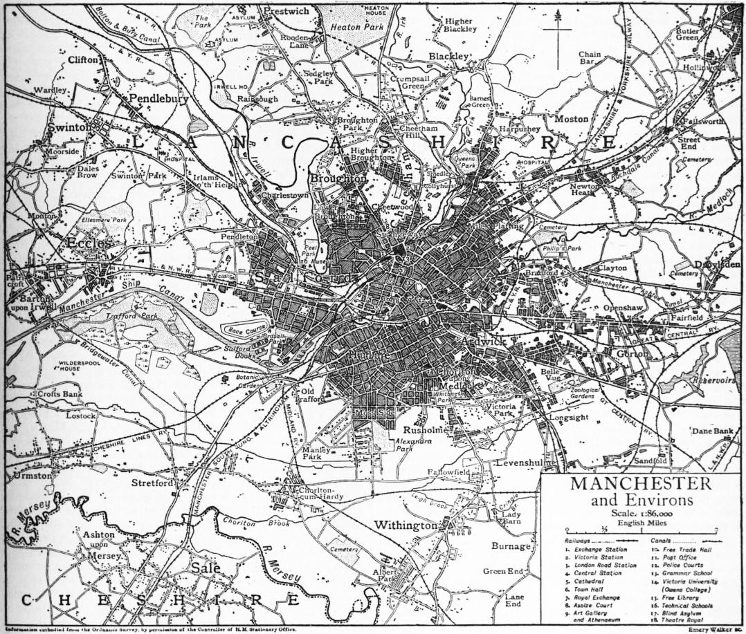
MANCHESTER, a city and county of a city, municipal, county and parliamentary borough of Lancashire, England, 189 m. N.W. by N. of London, and 31 m. E. by N. of Liverpool. It stands for the most part on a level plain, the rising ground being chiefly on the north side. The rivers are the Irwell, the Medlock, the Irk, and the Tib, the last entirely overarched and covered by streets and warehouses. The Irwell, which separates Manchester from Salford, is crossed by a series of bridges and discharges itself into the Mersey, which is about 10 m. distant. The chief part of the district, before it was covered with the superficial drift of sand, gravel and clay, consisted of upper New Red Sandstone with slight portions of lower New Red Sandstone, magnesian marls and upper red marls, hard sandstone and limestone rock, and cold clays and shales of contiguous coal-fields. The city, as its thousands of brick-built houses show, has been for the most part dug out of its own clay-fields. The parliamentary and municipal boroughs of Manchester are not conterminous. The city boundaries, which in 1841 enclosed 4293 acres, have been successively enlarged and now enclose 19,914 acres.
There are four large stations for the Lancashire & Yorkshire, London & North-Western, the Midland, Cheshire lines, Great Northern, and Great Central railways, and many subsidiary stations for local traffic. Tramways, as well as railways, run from Manchester to Oldham, Ashton, Eccles, Stockport, &c., with which places the city is connected by continuous lines of street. The length of the streets in the city of Manchester is 758 m. (exclusive of those in the district of Withington, which joined the city in 1905). The tramway lines within the city boundaries extend to 111 m., and in addition there are 58 m. leased to the corporation by adjacent local authorities. As a matter of fact, the whole of south-east Lancashire and some portions of Cheshire are linked to Manchester by railways and tramways so as to form one great urban area, and the traveller passes from one town to another by lines of street which, for the most part, are continuous. Facility of communication is essential to the commercial prosperity of Manchester, and its need was recognized by the duke of Bridgewater, whose canal, constructed in 1761, has now been absorbed by the Manchester Ship Canal (q.v.). The making of this early waterway was an event only less important than the opening of the Manchester & Liverpool railway in 1830.
The township of Manchester, which forms the nucleus of the city, is comparatively small, and outlying hamlets having been added, its size has increased without regularity of plan. Roughly speaking, the city forms a square, with Market Street as its central thoroughfare. The tendency of recent development is to reduce the irregularities so that the other main streets may either run parallel to or intersect Market Street. Deansgate, which formerly ended in a narrow tangle of buildings, is now a broad road with many handsome buildings, and the same process of widening, enlarging and rebuilding is going on, more or less, all over Manchester. Market Street, which has not been widened since 1820, has been termed, and with some reason, “the most congested street in Europe”; but relief is anticipated from some of the other street improvements. The centre of the city is occupied by business premises; the factories and workshops are mainly on the eastern side. The most important of the public buildings are in the centre and the south. The latter is also the most favoured residential district, and at its extremity is semi-rural in character. Large masses of the population live beyond the city boundary and come to their daily avocations by train and tram. Such a population is rarely homogeneous and Manchester attracts citizens from every part of the globe; there are considerable numbers of German, Armenian and Jewish residents. The houses are for the most part of brick, the public buildings of stone, which is speedily blackened by the smoky atmosphere. Many of the warehouses are of considerable architectural merit, and in recent years the use of terra-cotta has become more common. It is only in the suburbs that gardens are possible; the air is laden with black dust, and the rivers, in spite of all efforts, are in the central part of the city mere dirty ditches. It is impossible to describe Manchester in general terms, for within the city boundaries the conditions vary from the most squalid of slums to suburban and almost rural beauty.
Churches.—Manchester is the seat of an Anglican bishopric, and the chief ecclesiastical building is the cathedral, which, however, was built simply as a parish church, and, although a fine specimen of the Perpendicular period, is by no means what might be expected as the cathedral of an important and wealthy diocese. In the course of restoration a piece of Saxon sculpture came to light. This “Angel stone” represents a winged figure with a scroll inscribed In manus tuas Domine in characters of the 8th century. The bulk of the building belongs to the early part of the 15th century. The first warden was John Huntington, rector of Ashton, who built the choir. The building, which was noticed for its hard stone by Leland when he visited the town, did not stand time and weather well, and by 1845 some portions of it were rapidly decaying. This led to its restoration by James P. Holden. By 1868 the tower was almost completely renovated in a more durable stone. Further restoration was carried out by J. S. Crowther, and the addition of a porch and vestries was executed by Basil Champneys. The total length is 220 ft. and the breadth 112 ft. There are several stained-glass windows, including one to the memory of “Chinese Gordon.” The recumbent statues of Bishop James Fraser and of Hugh Birley, M.P., should also be named. In the Ely chapel is the altar tomb of Bishop James Stanley. In the stalls there are some curious miserere carvings. The tower is 139 ft. high, and contains a peal of ten bells, chiefly from the foundry of the Rudhalls. There are two organs, one by Father Smith, and a modern one in an oak case designed by Sir G. Scott. The parish church was made collegiate in 1422, and when in 1847 the bishopric of Manchester was created the warden and fellows became dean and canons and the parish church became the cathedral. The first bishop was James Prince Lee, who died in 1869; the second was James Fraser, who died in 1885; the third was James Moorhouse, who resigned in 1903 and was succeeded by Edmund Arbuthnott Knox. The church endowments are considerable and have been the subject of a special act of parliament, known as the Manchester Rectory Division Act of 1845, which provides £1500 per annum for the dean and £600 to each of the four canons, and divides the residue among the incumbents of the new churches formed out of the old parish.
Of the Roman Catholic churches that of the Holy Name, which belongs to the Jesuits, is remarkable for its costly decoration. The Greek Church and most of the Nonconformist bodies have places of worship. There are twelve Jewish synagogues. The meeting-house of the Society of Friends is said to be the largest of the kind in the kingdom and will seat 1200 persons.
Public Buildings.—The Royal Infirmary, founded in 1752, having become inadequate for its purposes, a new building has been erected on the south side of the city near the university, from designs by Edwin T. Hall and John Brooke; it was opened in 1909 by king Edward VII. The central site in Piccadilly thus became available for other purposes, and the corporation gave instructions for plans to be made for a new library and art gallery. The art gallery already existing in 1909 was founded as the Royal Institution, but in 1882 passed under the control of the city council. The building was designed by Sir Charles Barry. The collection contains some fine paintings by Etty, Millais, Leighton and other artists. The sculpture includes casts of the Elgin marbles and a statue of Dr John Dalton by Chantrey. The most striking of the public buildings is the town hall, probably the largest municipal building in the country, but no longer entirely adequate to the increasing business of the city council. It was completed in 1877 from designs by Alfred Waterhouse, who selected as the style of architecture a form of Gothic, but treated it very freely as purposes of utility required. The edifice covers 8000 sq. yds., and includes more than two hundred and fifty rooms. The building consists of continuous lines of corridors surrounding a central courtyard and connected by bridges. The principal tower is 286 ft. high to the top of the ball, and affords a view which extends over a large part of south Lancashire and Cheshire and is bounded only by the hills of Derbyshire. The tower contains a remarkable peal of bells by Taylor of Loughborough, forming an almost perfect chromatic scale of twenty-one bells; each bell has on it a line from canto 105 of Tennyson’s In Memoriam. The great hall is 100 ft. long and 50 ft. wide, and contains a magnificent organ built by Cavaillé-Coll of Paris. The twelve panels of this room are filled with paintings by Ford Madox Brown, illustrating the history and progress of the city. The royal exchange is a fine specimen of Italian architecture and was erected in 1869; the great meeting-hall is one of the largest rooms in England, the ceiling having a clear area, without supports, of 120 ft. in width. The exchange is seen at its best on market days (Tuesday and Friday). The assize courts were built in 1864 from designs by Waterhouse. The style is a mixture of Early English and Decorative, and a large amount of decorative art has been expended on the building. The branch Bank of England is a Doric building designed by C. R. Cockerell. There are separate town-halls for the townships of Ardwick, Chorlton, Hulme, Cheetham, Broughton and Pendleton. The Free Trade hall is a fine structure in the Lombardo-Venetian style, and its great hall will accommodate about five thousand people. It is used for public meetings, concerts, &c., and was built by Edward Walters. The Athenaeum, designed by Barry, was founded by Richard Cobden and others associated with him for “the advancement and diffusion of knowledge.” The institution has, perhaps, not developed exactly on the lines contemplated by its promoters, but it has been very useful. The advantages enjoyed by members of social clubs, with the addition of facilities for educational classes and the use of an excellent news-room and a well-selected library, are offered in return for a payment which does not amount to a penny a day. The mechanics’ institution has developed into the school of Technology, which now forms a part of the university. The Portico is a good specimen of the older proprietary libraries and newsrooms. It dates from 1806, and has a library. The Memorial Hall was built to commemorate the memory of the ejected ministers of 1662; it is used for meetings, scientific, educational, musical and religious. The Whitworth Institute is governed by a corporate body originating from the liberal bequests of Sir Joseph Whitworth. The Institute contains a valuable collection of works of art and stands in the centre of a woodland park. In the park, which has been transferred to the corporation, is a sculpture group of “Christ and the Children,” executed by George Tinworth from the designs of R. D. Darbishire, by whom it was presented. The assize courts, built from designs by Waterhouse (1864), the post office (1887), and the police courts (1871) should also be named. Many fine structures suffer from being hemmed in by streets which prevent the proportions from being seen to advantage.
Monuments.—In Piccadilly are bronze statues of Wellington, Watt, Dalton, Peel and Queen Victoria. Another statue of the Queen, by the Princess Louise, is placed on the new porch of the cathedral. A bronze statue of Cobden occupies a prominent position in St Ann’s Square. There also is the South African War Memorial of the Manchester Regiment. The marble statue of the Prince Consort, covered by a Gothic canopy of stone, is in front of the town hall, which dwarfs what would otherwise be a striking monument. In Albert Square there are also statues of Bishop Fraser, John Bright, Oliver Heywood and W. E. Gladstone. A statue of J. P. Joule is in the town hall, which also contains memorials of other worthies. The Queen’s Park has a statue of Benjamin Brierley, a well-known writer in the Lancashire dialect. The most picturesque is Matthew Noble’s bronze statue of Cromwell, placed on a huge block of rough granite as pedestal. It stands at the junction of Deansgate and Victoria Street, near the cathedral, and was presented to the town by Mrs E. S. Heywood.
Education.—There are many educational facilities. The oldest institution is the grammar school, which was founded in 1519 by Hugh Oldham, bishop of Exeter, a native of the town. The master and usher appointed by the bishop were to teach freely every child and scholar coming to the school, “without any money or reward taken”; and the bishop forbade the appointment of any member of the religious orders as head master. Some corn mills were devised for the maintenance of the school, which was further endowed at both the universities by Sarah, duchess of Somerset, in 1692. The school has now two hundred and fifty free scholars, whilst other pupils are received on payment of fees. Among those educated at the grammar school were Thomas De Quincey, Harrison Ainsworth and Samuel Bamford the Radical. After the grammar school the oldest educational foundation is that of Humphrey Chetham, whose bluecoat school, founded in 1653, is housed in the building formerly occupied by the college of clergy. This also contains the public library founded by Chetham, and is the most interesting relic of antiquity in the city. The educational charity of William Hulme (1631-1691) is administered under a scheme drawn up in 1881. Its income is nearly £10,000 a year, and it supports a grammar school and aids education in other ways. There are three high schools for girls. The Nicholls hospital was founded in 1881 for the education of orphan boys. Manchester was one of the first places to adopt the powers given by Forster’s Act of 1870, and on the abolition of school boards the educational supervision was transferred to a committee of the corporation strengthened by co-opted members. In addition to the elementary schools, the municipality provides a large and well-equipped school of technology, and a school of art to which is attached an arts and crafts museum. There are a pupil teachers’ college, a school of domestic economy, special schools for feeble-minded children, and a Royal College of Music. The schools for the deaf and dumb are situated at Old Trafford, in a contiguous building of the same Gothic design as the blind asylum, to which Thomas Henshaw left a bequest of £20,000. There is also an adult deaf and dumb institution, containing a news-room, lecture hall, chapel, &c., for the use of deaf mutes.
The Victoria University of Manchester has developed from the college founded by John Owens, who in 1846 bequeathed nearly £100,000 to trustees for an institution in which should be taught “such branches of learning and science as were then or might be hereafter usually taught in English universities.” It was opened in 1851 in a house which had formerly been the residence of Cobden. In 1872 a new college building was erected on the south side of the town from designs by Waterhouse. In 1880 a university charter was granted, excluding the faculties of theology and medicine, and providing for the incorporation of University College, Liverpool, and the College of Science, Leeds. The federal institution thus created lasted until 1903, when the desire of Liverpool for a separate university of its own led to a reconstruction. Manchester University consists of one college—Owens College—in its greatly enlarged form. The buildings include the Whitworth Hall (the gift of the legatees of Sir Joseph Whitworth), the Manchester Museum and the Christie Library, which is a building for the university library given by R. C. Christie, who also bequeathed his own collection. Dr Lee, the first bishop of Manchester, left his library to Owens College, and the legatees of Sir Joseph Whitworth bought and presented E. A. Freeman’s books. The library has received other important special collections. The benefactions to the university of Thomas Ashton are estimated at £80,000. There are in Manchester a number of denominational colleges, Wesleyan, Primitive Methodist, Unitarian, Baptist, &c., and many of the students preparing for the ministry receive their arts training at the university, the theological degrees of which are open to students irrespective of creed.
Libraries, Museums and Societies.—Manchester is well provided with libraries. The Chetham library, already named, contains some rare manuscripts, the gem of the collection being a copy of the historical compilation of Matthew Paris, with corrections in the author’s handwriting. There is a large collection of matter relating to the history and archaeology of Lancashire and Cheshire, including the transcripts of Lancashire MSS. bequeathed by Canon F. R. Raines. The collections of broadsides formed by Mr J. O. Halliwell-Phillipps, and the library of John Byrom, rich in mystics and shorthand writers, should also be named. The Manchester Free Libraries were founded by Sir John Potter in 1852. There is now a reference library containing about 170,000 volumes, including an extensive series of English historical works, a remarkable collection of books of political economy and trade, and special collections relating to local history, Dr Thomas Fuller, shorthand and the gipsies. The Henry Watson Music Library, and the Thomas Greenwood Library for librarians were presented to the reference library, and the Foreign Library was purchased. Affiliated to the reference library there are nineteen libraries, each of which includes a lending department and reading rooms. The municipal libraries contain in the aggregate over 366,000 vols. There are also libraries in connexion with the Athenaeum, the School of Technology, the Portico, and many other institutions. The most remarkable of the Manchester libraries is that founded by Mrs Enriqueta Rylands, and named the John Rylands Library in memory of her husband. The beautiful building was designed by Basil Champneys; the library includes the famous Althorp collection, which was bought from Earl Spencer. Mrs Rylands died in 1908, and by her will increased the endowment of the library so that it has an income of £13,000 yearly. She also bequeathed her own library.
Manchester possesses numerous literary and scientific associations. The oldest of these, the Literary and Philosophical Society, founded in 1781, has a high reputation, and has numbered among its working members John Dalton, Eaton Hodgkinson, William Fairbairn, J. P. Joule, H. E. Roscoe and many other famous men of science. It has published a series of memoirs and proceedings. The Manchester Statistical Society was the first society of the kind established in the kingdom, and has issued Transactions containing many important papers. The Field Naturalists’ and Archaeologists’ Society, the Microscopical Society, the Botanists’ Association, and the Geological Society may also be named. Manchester is the headquarters of the Lancashire and Cheshire Antiquarian Society and of several printing clubs, the Chetham, the Record, the Lancashire Parish Registers societies. Seven daily papers are published, and various weekly and other periodicals. The journalism of Manchester takes high rank, the Manchester Guardian (Liberal) being one of the best newspapers in the country, while the Manchester Courier (Unionist) has an important local influence. The Manchester Quarterly is issued by the Manchester Literary Club, which was founded in 1862. The success of the Art Treasures Exhibition in 1857 was repeated in the Jubilee Exhibition of 1887. The Manchester Academy of Fine Arts is a society of artists, and holds an annual exhibition in the city art gallery.
Parks and Open Spaces.—There are fifty-three parks and open spaces. The Queen’s Park, at Harpurhey, is pleasantly situated, though surrounded by cottages and manufactories. Philips Park is also attractive, in spite of its close proximity to some of the most densely populated portions of the town. The Alexandra Park has very good ornamental grounds and a fine cactus house with a remarkable collection presented by Charles Darrah. Some of the open spaces are small; Boggart Hole Clough, where great efforts have been made to preserve the natural features, is 76 acres in extent, and was the largest until 1902, when Heaton Park, containing 692 acres, was purchased. It was formerly the seat of the earls of Wilton, and includes Heaton House, one of Wyatt’s structures. In the Queen’s Park there is a museum, and periodical exhibitions of works of art are held. The total area of the city parks is 1146 acres. The corporation are also responsible for four cemeteries, having a total area of 228 acres.
Recreation.—There are nine theatres, mostly large, and eight music halls. The Theatre Royal was established as a patent theatre. When the bill for it was before the House of Lords in 1775 it was advocated as an antidote to Methodism. The Bellevue Zoological Gardens is a favourite holiday place for working people. The Ancoats Recreation Committee have since 1882 had Sunday lectures, and occasional exhibitions of pictures, window gardening, &c. The Ancoats Art Museum was founded to carry out the educational influences of art and culture generally. In addition to works of art, there are concerts, lectures, reading circles, &c. The museum is worked in connexion with a university settlement. The German element in the population has largely influenced the taste for music by which Manchester is distinguished, and the orchestral concerts (notably under Charles Hallé) are famous.
Population.—From a census taken in 1773 it appears that there were then in the township of Manchester and its out-townships 36,267 persons. The first decennial census, 1801, showed the population to be 75,275; in 1851 it was 303,382; in 1901, 606,824. It is not easy to make an exact comparison between different periods, because there have been successive enlargements of the boundaries. The population has overflowed into the surrounding districts, and if all that belongs to the urban area, of which it is the centre, were included, greater Manchester would probably rival London in the number of its inhabitants.
Manufactures and Commerce.—Manchester is the centre of the English cotton industry (for details see Cotton and Cotton Manufacture), but owing to the enhanced value of land many mills and workshops have been removed to the outskirts and to neighbouring villages and towns, so that the centre of Manchester and an ever-widening circle around are now chiefly devoted not so much to production as to the various offices of distribution. It would be a mistake, however, to regard Manchester as solely dependent upon the industries connected with cotton. There are other important manufactures which in another community would be described as gigantic. Wool and silk are manufactured on a considerable scale, though the latter industry has for some years been on the decline. The miscellaneous articles grouped under the designation of small-wares occupy many hands. Machinery and tools are made in vast quantities; the chemical industries of the city are also on a large scale. In short, there are but few important manufactures that are wholly unrepresented. The proximity of Manchester to the rich coal-fields of Lancashire has had a marked influence upon its prosperity; but for this, indeed, the rapid expansion of its industries would have been impossible.
The Manchester Bankers’ Clearing House returns show an almost unbroken yearly increase. The amount in 1872 was £72,805,510; in 1907 it was £320,296,332; by the severe depression of 1908 it was reduced to £288,555,307. Another test of prosperity is the increase in rateable value. In 1839 it was £669,994; in 1871, £1,703,627; in 1881, £2,301,225; in 1891, £2,798,005; in 1901, £3,394,879; in 1907, £4,191,039; in 1909, £4,234,129.
The commercial institutions of Manchester are too numerous for detailed description; its chamber of commerce has for more than sixty years exercised much influence on the trade of the district and of the nation. Manchester is the headquarters of the Co-operative Wholesale Society, and indeed of the cooperative movement generally.
The most important event in the modern history of the district is the creation of the Manchester Ship Canal (q.v.), by which Manchester and Salford have a direct communication with the sea at Eastham, near Liverpool. The canal was opened for traffic in January 1894. The official opening ceremony was on the 21st of May 1894, when Queen Victoria visited Manchester. The total expenditure on capital account has been £16,567,881. The original share capital of £8,000,000 and £1,812,000, raised by debentures, having been exhausted, the corporation of Manchester advanced on loan a further sum of £5,000,000.
Municipality.—Manchester received a municipal charter in 1838, received the title of city in 1853, and became a county borough in 1889. The city is divided into 30 wards, and the corporation consists of 31 aldermen and 93 councillors. The mayor received the title of lord mayor in 1893. Unlike some of the municipalities, that of Manchester makes no pecuniary allowance to its lord mayor, and the office is a costly one.
The water supply is controlled by the corporation. The works at Longdendale, begun in 1848, were completed, with extensions in 1884, at a cost of £3,147,893. The area supplied by Manchester waterworks was about 85 square miles, inhabited by a million people. The increase of trade and population led to the obtaining of a further supply from Lake Thirlmere, at the foot of Helvellyn and 96 miles from Manchester. The watershed is about 11,000 acres. The daily consumption is over 38 million gallons. Manchester supplies in bulk to many local authorities in the district between Thirlmere and the city. The corporation have also established works for the supply of hydraulic and electric power.
The gas lighting of Manchester has been in the hands of the corporation for many years, as also the supply of electricity both for lighting and energy. When the works are complete the electricity committee will supply an area of 45 sq. m.
Sanitary Condition.—Dr John Tatham constructed a Manchester life-table based on the vital statistics of the decennium 1881-1890, from which it appeared that, while in England and Wales of 1000 men aged 25 nearly 800 survived to be 45 and of 1000 aged 45, 569 survived to be 65, in Manchester the survivors were only 732 and 414 respectively. The expectation of life, at 25, was, for England and Wales 36.12 years, and for Manchester 30.69 years. But the death-rate has since rapidly decreased; in 1891 it was 26.0 per thousand living; in 1901 it was 21.6; in 1906 it was 19.0; in 1907 it was 17.9. The deaths of infants under one year old amounted to 169 per 1000. The reports of the medical officer show that whilst the density of the population, the impurity of the atmosphere, and the pollution of the streams are difficult elements in the sanitary problem, great efforts have been made towards improving the health of the people. The birth-rate in 1907 was 28.4, but the population is augmented by immigration as well as by natural increase. The number of persons to the acre is 33.
Administration of Justice.—The city has a stipendiary magistrate who, in conjunction with lay magistrates, tries cases of summary jurisdiction in the police courts. There are also quarter sessions, presided over by a recorder. Separate sessions are held for the Salford hundred. Certain sittings of the Court of Chancery for the duchy of Lancaster are held in Manchester. In addition to the county court, there is an ancient civil court known as the Salford Hundred Court of Record. Assizes have been held since 1866.
Parliamentary Representation.—By the first Reform Bill Manchester received in 1832 two representatives. In 1868 this was increased to three, but each voter had only two votes. In 1885 the city was divided into six divisions, each returning one member. Owing to the extension of the city boundaries there are Manchester voters in the Stretford, Prestwich and Gorton parliamentary divisions.
History.—Very little is known with certainty of the early history of Manchester.1 A Roman station of some importance existed at Castlefield, and a fragment of the wall still exists. Another, perhaps earlier, was at Hunt’s Bank. In the 18th century considerable evidences of Roman occupation were still visible; and from time to time, in the course of excavation (especially during the making of the Bridgewater Canal), Roman remains have been found. The coins were chiefly those of Vespasian, Antoninus Pius, Trajan, Hadrian, Nero, Domitian, Vitellius and Constantine. Investigations by the Lancashire and Cheshire Antiquarian Society and the Classical Association have brought to light many relics, chiefly of pottery. The period succeeding the Roman occupation is for some time legendary. As late as the 17th century there was a tradition that Tarquin, an enemy of King Arthur, kept the castle of Manchester, and was killed by Lancelot of the Lake. The references to the town in authentic annals are very few. It was probably one of the scenes of the missionary preaching of Paulinus; and it is said (though by a chronicler of comparatively late date) to have been the residence of Ina, king of Wessex, and his queen Ethelberga, after he had defeated Ivor, somewhere about the year 689. Almost the only point of certainty in its history before the Conquest is that it suffered greatly from the devastations of the Danes, and that in 923 Edward, who was then at Thelwall, near Warrington, sent a number of his Mercian troops to repair and garrison it. In Domesday Book Manchester, Salford, Rochdale and Radcliffe are the only places named in south-east Lancashire, a district now covered by populous towns. Large portions of it were then forest, wood and waste lands. Twenty-one thanes held the manor or hundred of Salford among them. The church of St Mary and the church of St Michael in Manchester are both named in Domesday, and some difficulty has arisen as to their proper identification. Some antiquaries consider that the passage refers to the town only, whilst others think it relates to the parish, and that, while St Mary’s is the present cathedral, St Michael’s would be the present parish church of Ashton-under-Lyne. In 1301 Manchester received a charter of manorial liberties and privileges from its baron, Thomas Gresley, a descendant of one to whom the manor had been given by Roger of Poictou, who was created by William the Conqueror lord of all the land between the rivers Mersey and Ribble. The Gresleys were succeeded by the De la Warrs, the last of whom was educated for the priesthood, and became rector of the town. To avoid the evil of a non-resident clergy, he made considerable additions to the lands of the church, in order that it might be endowed as a collegiate institution. A college of clergy was thus formed, whose fellows were bound to perform the necessary services at the parish church, and to whom the old baronial hall was granted as a place of residence. The manorial rights passed to Sir Reginald West, a descendant of Joan Gresley, who was summoned to parliament as Baron de la Warre. The West family, in 1579, sold the manorial rights for £3000 to John Lacy, who, in 1596, resold them to Sir Nicholas Mosley, whose descendants enjoyed the emoluments derived from them until 1845, when they were purchased by the municipality of Manchester for a sum of £200,000. The lord of the manor had the right to tax and toll all articles brought for sale into the market of the town. But, though the inhabitants were thus to a large extent taxed for the benefit of one individual, they had a far greater amount of local self-government than might have been supposed, and the court leet, which was then the governing body of the town, had, though in a rudimentary form, nearly all the powers now possessed by municipal corporations. This court had not only control over the watching and warding of the town, the regulation of the water supply, and the cleaning of the streets, but also had power, which at times was used freely, of interfering with the private liberty of their fellow-citizens. Thus, no single woman was allowed to be a householder; no person might employ other than the town musicians; and the amount to be spent at wedding feasts and other festivities was carefully settled. Under the protection of the barons the town appears to have steadily increased in prosperity, and it early became an important seat of the textile manufactures. Fulling mills were at work in the district in the 13th century; and documentary evidence exists to show that woollen manufactures were carried on in Ancoats at that period. In 1538 Leland described it as “the fairest, best-builded, quickest, and most populous town in Lancashire.” The right of sanctuary granted to the town in 1540 was found so detrimental to its industrial pursuits that after very brief experience the privilege was taken away. The college of Manchester was dissolved in 1547, but was refounded in Mary’s reign. Under her successor the town became the headquarters of the commission for establishing the Reformed religion. In 1641 we hear of the Manchester people purchasing linen yarn from the Irish, weaving it, and returning it for sale in a finished state. They also brought cotton wool from Smyrna to work into fustians and dimities. An act passed in the reign of Edward VI. regulates the length of cottons called Manchester, Lancashire and Cheshire cottons. These, notwithstanding their name, were probably all woollen textures. It is thought that some of the Flemish weavers who were introduced into England by Queen Philippa of Hainault were settled at Manchester; and Fuller has given an exceedingly quaint and picturesque description of the manner in which these artisans were welcomed by the inhabitants of the country they were about to enrich with a new industry. The Flemish weavers were in all probability reinforced by religious refugees from the Low Countries.
In the civil wars, the town was besieged by the Royalists under Lord Strange (better known as earl of Derby—“the great Stanley”); but was successfully defended by the inhabitants under the command of a German soldier of fortune, Colonel Rosworm, who complained with some bitterness of their ingratitude to him. An earlier affray between the Puritans and some of Lord Strange’s followers is said to have occasioned the shedding of the first blood in the struggle between the king and parliament. The year 1694 witnessed the trial of those concerned in the so-called Lancashire plot, which ended in the triumphant acquittal of the supposed Jacobites. That the district really contained many ardent sympathizers with the Stuarts was, however, shown in the rising of 1715, when the clergy ranged themselves to a large extent on the side of the Pretender; and was still more clearly shown in the rebellion of 1745, when the town was occupied by Prince Charles Edward Stuart, and a regiment, known afterwards as the Manchester regiment, was formed and placed under the command of Colonel Francis Townley. In the fatal retreat of the Stuart troops the Manchester contingent was left to garrison Carlisle, and surrendered to the duke of Cumberland. The officers were taken to London, where they were tried for high treason and beheaded on Kennington Common.
The variations of political action in Manchester had been exceedingly marked. In the 16th century, although it produced both Roman Catholic and Protestant martyrs, it was earnestly in favour of the Reformed faith, and in the succeeding century it became indeed a stronghold of Puritanism. Yet the successors of the Roundheads who defeated the army of Charles I. were Jacobite in their sympathies, and by the latter half of the 18th century had become imbued with the aggressive form of patriotic sentiment known as anti-Jacobinism, which showed itself chiefly in dislike of reform and reformers of every description. A change, however, was imminent. The distress caused by war and taxation, towards the end of the 18th and the beginning of the 19th century, led to bitter discontent, and the anomalies existing in the parliamentary system of representation afforded only too fair an object of attack. While single individuals in some portions of the country had the power to return members of parliament for their pocket boroughs, great towns like Manchester were entirely without representation. The popular discontent was met by a policy of repression, culminating in the affair of Peterloo, which may be regarded as the starting-point of the modern reform agitation. This was in 1819, when an immense crowd assembled on St Peter’s Fields (now covered by the Free Trade Hall and warehouses) to petition parliament for a redress of their grievances. The Riot Act was read by a clerical magistrate; but in such a manner as to be quite unheard by the mass of the people; and drunken yeomanry cavalry were then turned loose upon the unresisting mass of spectators. The yeomanry appear to have used their sabres freely; several people killed and many more injured; and, although the magistrates received the thanks of the prince regent and the ministry, their conduct excited the deepest indignation throughout the entire country. Those who had organized the meeting, including “Orator” Hunt with Samuel Bamford and other working men, were imprisoned.
Naturally enough, the Manchester politicians took an important part in the Reform agitation; when the Act of 1832 was passed, the town sent as its representatives the Right Hon. C. P. Thomson, vice-president of the board of trade, and Mark Philips. With one notable exception, this was the first time that Manchester had been represented in parliament since its barons had seats in the House of Peers in the earlier centuries. In 1654 Charles Worsley and R. Radcliffe were nominated to represent it in Cromwell’s parliament. Worsley was a man of great ability, and has a place in history as the man who carried out the injunction of the Protector to “remove that bauble,” the mace of the House of Commons. The agitation for the repeal of the corn laws had its headquarters at Manchester, and the success which attended it, not less than the active interest taken by its inhabitants in public questions, has made the city the home of other projects of reform. The “United Kingdom Alliance for the Suppression of the Liquor Traffic” was founded there in 1853, and during the continuance of the American War the adherents both of the North and of the South deemed it desirable to have organizations in Manchester to influence public opinion in favour of their respective causes. A charter of incorporation was granted in 1838; a bishop was appointed in 1847; and the town became a city in 1853. The Lancashire cotton famine, caused by the Civil War in America, produced much distress in the Manchester district, and led to a national movement to help the starving operatives. The more recent annals of Manchester are a record of industrial and commercial developments, and of increase in educational opportunities of all kinds. Politically Manchester was Liberal, of one or other shade, under the first Reform Act; a Conservative member was first elected in 1868, and in 1874 two. Under household suffrage in 1885 that party secured five out of six members; in 1886 and 1892, three out of six. In 1895 and 1900 five Unionists were elected, but in 1906 six Liberals were returned, one of whom (Mr Winston Churchill) was defeated at a by-election in 1908. In 1910 three Liberals, two Labour members and one Conservative were elected.
Authorities.—Although several excellent books have been written on subjects connected with the town, there is no adequate modern history. The History of Manchester, by the Rev. John Whitaker, appeared in 1771; it is a mere fragment, and, though containing much important matter, requires to be very discreetly used. The following may be recommended: John Reilly, History of Manchester, (1861); R. W. Procter, Manchester in Holiday Dress (1866), Memorials of Manchester Streets (1874), Memorials of Byegone Manchester (1880); Richard Buxton, Botanical Guide to Manchester, &c. (2nd ed., 1859); Leo Grindon, Manchester Flora (1859); Edward Baines, History of Lancashire, edited by Croston (1886-1893), 5 vols.; W. A. Shaw, Manchester, Old and New (1894); W. E. A. Axon, Annals of Manchester (1885), Cobden as a Citizen (1906); Harry Rawson, Historical Record of some Recent Enterprises of the Corporation of Manchester (1894); Official Manual of Manchester and Salford (1909); J. P. Earwaker, Court Leet Records of Manchester, 1552-1686, 1731-1846 (1884-1890), 12 vols.; Constable’s Accounts, 1612-1647, 1743-1776 (1891-1892), 3 vols.; Manchester Municipal Code (1894-1899), 5 vols.; George Saintsbury, Manchester (1887); Thomas Swindells, Manchester Streets and Manchester Men (1906-1907), 3 vols.; James Tait, Medieval Manchester (1904); Charles Roeder, Roman Manchester (1900); Sir Bosdin Leech, History of the Manchester Ship Canal (1907), 2 vols.
(W. E. A. A.)
1 In the Antonine Itinerary the name Mancunium (q.v.) or Mamucium is given. This is the origin of the modern name, and has supplied the adjective “Mancunian” (cf. “Old Mancunians” applied to old boys of Manchester Grammar School).
MANCHESTER (popularly Manchester-by-the-Sea), a township of Essex county, Massachusetts, U.S.A., about 25 m. N.E. of Boston, on Massachusetts Bay. Pop. (1900), 2522; (1905, state census), 2618; (1910), 2673. Area, 7.64 sq. m. It is served by the Boston & Maine railroad, and is connected with neighbouring towns and cities by electric lines. The township, heavily wooded in parts, and with picturesque shores alternating between rocky headlands and sandy beaches, stretches for several miles along the coast between Beverly on the west and Gloucester on the east. It is one of the most beautiful watering-places in America, and is the favourite summer residence of many of the foreign diplomats at Washington. The “singing beach” is a stretch of white sand, which, when trodden upon, emits a curious musical sound. Manchester, originally a part of Salem, was settled about 1630 and was at first known as Jeffrey’s Creek. It was incorporated separately under its present name in 1645.
See Manchester Town Records (2 vols., Salem, 1889-1891), and D. F. Lamson, History of the Town of Manchester, 1645-1895 (Manchester, 1895).
MANCHESTER, the largest city of New Hampshire, U.S.A., and one of the county-seats of Hillsboro county, on the Merrimac river, at the mouth of the Piscataquog river, (by rail) 18 m. S. of Concord and 57 m. N.N.W. of Boston. Pop. (1890), 44,126; (1900), 56,987; (1910 U.S. census) 70,063. Of the total population in 1900, 24,257 were foreign-born, including 13,429 French-Canadians; and 37,530 were of foreign parentage (both parents foreign-born), including 18,839 of French-Canadian parentage. Manchester is served by the Southern, the Western, the White Mountains, and the Worcester Nashua & Portland divisions of the Boston & Maine railroad, and by inter-urban electric lines. It is situated on a plain about 90 ft. above the Merrimac river (which is spanned here by three bridges), commands extensive views of the beautiful Merrimac valley, and covers a land area of about 33 sq. m. On the east side of the city are two connected lakes known as Lake Massabesic (30 m. in circumference). Manchester is known for the attractive appearance of the residence districts in which the factory operatives live, detached homes and “corporation boarding-houses,” instead of tenement houses, being the rule. The Institute of Arts and Sciences (incorporated in 1898) provides lecture courses and classes in science, art and music. Among the other public buildings and institutions are the United States Government building, the city-hall, the county-court-house, the city library (1854; the outgrowth of the Manchester Athenaeum, established in 1844), St Anselm’s College (R.C.), a Roman Catholic cathedral, four Roman Catholic convents, the Elliot hospital, the Sacred Heart hospital and the hospital of Notre Dame de Lourdes, the State industrial school, the State house of correction, the Gale home for aged women, an old ladies’ home (R.C.), St Martha’s home for working girls, the Manchester children’s home and four orphan asylums. In the largest of five public squares is a soldiers’ monument, consisting of a granite column 50 ft. high, surmounted by a statue of Victory. The city has two parks, and in one of them, overlooking the Merrimac, is a monument to the memory of General John Stark, who was born and was buried here. The water-supply is obtained from Lake Massabesic. Amoskeag Falls in the Merrimac are 55 ft. in height, and by means of hydraulic canals Manchester is provided with a fine water-power. Steam power is also used, and the city is by far the most important manufacturing centre in the state. It is extensively engaged in the manufacture of cotton goods, boots and shoes, worsted goods, hosiery and other knit goods, and locomotives; among the other manufactures are linen goods, steam fire-engines, paper, edge tools, soap, leather, carriages and beer. The value of the city’s factory products increased from $24,628,345 in 1900 to $30,696,926 in 1905, or 24.6%. In 1905 Manchester produced 24.8% of the total factory product of the state. Manchester ranks fifth among the cities of the United States in cotton manufacturing, and ninth among the cities of the country in the manufacture of boots and shoes.
On account of the abundance of fish in the river here, Amoskeag Falls and vicinity were a favourite resort of the Penacook Indians, and it is said that John Eliot, the “Apostle to the Indians,” preached to them here in the summer of 1651. The first white settlement within the present limits of Manchester was made in 1722 by Scottish-Irish immigrants at Goffe’s Falls, 5 m. below Amoskeag Falls. In 1723 a cabin was built by some of these immigrants at the greater falls, and gradually a small settlement grew up there. In 1735 Massachusetts granted to a body of men known as “Tyng’s Snow-Shoe Scouts” and their descendants a tract of land 3 m. wide along the east bank of the Merrimac, designated as “Tyng’s Township.” The Scottish-Irish claimed this tract as part of their grant from New Hampshire, and there arose between the rival claimants a bitter controversy which lasted until May 1741, when the courts decided against the Massachusetts claimants. In 1751 the territory formerly known as “Tyng’s Township,” and sometimes called “Harrytown,” with portions of Chester and Londonderry, was incorporated as a township under the name Derryfield; in 1810 the name was changed to Manchester, the change having been suggested by the town’s manufacturing possibilities; and in 1846 Manchester was chartered as a city. The first sawmill was erected as early as 1736, and during the years from 1794 to 1807 a canal was constructed around the Amoskeag Falls through which to carry lumber. As late as 1830 the town had a population of only 877, but in 1831 the Amoskeag Manufacturing Company was incorporated, the construction of hydraulic canals and the erection of cotton mills followed, the villages of Piscataquog and Amoskeag were annexed in 1853, and the population increased to 3235 in 1840, to 8841 in 1860, and to 33,592 in 1880.
Consult M. D. Clarke, Manchester, A Brief Record of its Past and a Picture of its Present (Manchester, 1875).
MANCHESTER, a former city of Chesterfield county, Virginia, U.S.A., (on the S. side of the James river), since 1910 a part of Richmond. Pop. (1900), 9715, of whom 3338 were negroes; (1906 estimate), 9997. It is served by the Atlantic Coast Line, the Seaboard Air Line, and the Southern railways, by electric lines to Richmond and Petersburg, and by numerous river boats. It is finely situated in a bend of the river, with about 2 m. of water front; on the heights above is Forest Hill park, a pleasure resort, and adjacent to it Woodland Heights, a beautiful residential district. From the surrounding country come much agricultural produce, coal, lumber, bricks and granite. There is a good harbour and excellent water power. Among the manufactures are paper, flour, cotton goods, leather, brick, railway supplies, &c. The value of the city’s factory products increased from $1,621,358 in 1900 to $3,226,268 in 1905, or 99%.
MANCHESTER SHIP CANAL. The advantage of a waterway for the conveyance of goods between eastern Lancashire and the sea is so obvious that so far back as the year 1721 Thomas Steers designed a plan for continuing to Manchester the barge navigation which then existed between Liverpool and Warrington. Parliamentary powers were then obtained to improve the rivers Mersey and Irwell from Warrington to Manchester by means of locks and weirs. This work was successfully carried out, and proved of great benefit to the trade of the district. The duke of Bridgewater, who had made a canal from his collieries at Worsley to Manchester, afterwards continued the canal to the Mersey at Runcorn; this extension was opened in 1722 and competed with the Mersey and Irwell navigation, both routes being navigated by barges carrying about fifty tons of cargo. The Liverpool & Manchester railway at a later date afforded further facilities for conveyance of goods, but the high rates of carriage, added to heavy charges at the Liverpool docks, prejudiced trade, and the question was mooted of a ship canal to bring cotton, timber, grain and other goods direct to Manchester without transshipment. The first plan was made by William Chapman in 1825, and was followed by one designed by Henry Palmer in 1840, but it was not until the year 1882 that the movement was originated that culminated in the opening of the Manchester Ship Canal by Queen Victoria on the 21st of May 1894.