VOLUME XII SLICE I Gichtel, Johann to Glory (continued 8)
Reading edition
Down to the middle of the 19th century most of the Glamorgan valleys were famous for their beautiful scenery, but industrial operations have since destroyed most of this beauty, except in the so-called “Vale of Glamorgan,” the Vale of Neath, the “combes” and limestone gorges of Gower and the upper reaches of the Taff and the Tawe. The Vale of Neath is par excellence the waterfall district of South Wales, the finest falls being the Cilhepste fall, the Sychnant and the three Clungwyns on the Mellte and its tributaries near the Vale of Neath railway from Neath to Hirwaun, Scwd Einon Gam and Scwd Gladys on the Pyrddin on the west side of the valley close by, with Melin Court and Abergarwed still nearer Neath. There are also several cascades on the Dulais, and in the same district, though in Breconshire, is Scwd Henrhyd on the Llech near Colbren Junction. Almost the only part of the county which is now well timbered is the Vale of Neath. There are three small lakes, Llyn Fawr and Llyn Fach near Craig y Llyn and Kenfig Pool amid the sand-dunes of Margam. The rainfall of the county varies from an average of about 25 in. at Porthcawl and other parts of the Vale of Glamorgan to about 37 in. at Cardiff, 40 in. at Swansea and to upwards of 70 in. in the northern part of the county, the fall being still higher in the adjoining parts of Breconshire whence Cardiff, Swansea, Merthyr and a large area near Neath draw their main supplies of water.
The county has a coast-line of about 83 m. Its two chief bays are the Burry estuary and Swansea, one on either side of the Gower Peninsula, which has also a number of smaller inlets with magnificent cliff scenery. The rest of the coast is fairly regular, the chief openings being at the mouths of the Ogmore and the Taff respectively. The most conspicuous headlands are Whiteford Point, Worms Head and Mumbles Head in Gower, Nash Point and Lavernock Point on the eastern half of the coast.
Geology.—The Silurian rocks, the oldest in the county, form a small inlier about 2 sq. m. in area at Rumney and Pen-y-lan, north of Cardiff, and consist of mudstones and sandstones of Wenlock and Ludlow age; a feeble representative of the Wenlock Limestone also is present. They are conformably succeeded by the Old Red Sandstone which extends westwards as far as Cowbridge as a deeply eroded anticline largely concealed by Trias and Lias. The Old Red Sandstone consists in the lower parts of red marls and sandstones, while the upper beds are quartzitic and pebbly, and form bold scarps which dominate the low ground formed by the softer beds below. Cefn-y-bryn, another anticline of Old Red Sandstone (including small exposures of Silurian rocks), forms the prominent backbone of the Gower peninsula. The next formation is the Carboniferous Limestone which encircles and underlies the great South Wales coal-field, on the south of which, west of Cardiff, it forms a bold escarpment of steeply-dipping beds surrounding the Old Red Sandstone anticline. It shows up through the Trias and Lias in extensive inliers near Bridgend, while in Gower it dips away from the Old Red Sandstone of Cefn-y-bryn. On the north of the coal-field it is just reached near Merthyr Tydfil. The Millstone Grit, which consists of grits, sandstones and shales, crops out above the limestone and serves to introduce the Coal Measures, which lie in the form of a great trough extending east and west across the county and occupying most of its surface. The coal seams are most numerous in the lower part of the series; the Pennant Sandstone succeeds and occupies the inner parts of the basin, forming an elevated moorland region deeply trenched by the teeming valleys (e.g. the Rhondda) which cross the coal-field from north to south. Above the Pennant Sandstone still higher coals come in. Taken generally, the coals are bituminous in the south-east and anthracitic in the north-west.
After the Coal Measures had been deposited, the southern part of the region was subjected to powerful folding; the resulting anticlines were worn down during a long period of detrition, and then submerged slowly beneath a Triassic lake in which accumulated the Keuper conglomerates and marls which spread over the district west of Cardiff and are traceable on the coast of Gower. The succeeding Rhaetic and Lias which form most of the coastal plain (the fertile Vale of Glamorgan) from Penarth to near Bridgend were laid down by the Jurassic sea. A well-marked raised beach is traceable in Gower. Sand-dunes are present locally around Swansea Bay. Moraines, chiefly formed of gravel and clay, occupy many of the Glamorgan valleys; and these, together with the striated surfaces which may be observed at higher levels, are clearly glacial in origin. In the Coal Measures and the newer Limestones and Triassic, Rhaetic and Liassic conglomerates, marls and shales, many interesting fossils have been disinterred: these include the remains of an air-breathing reptile (Anthracespeton). Bones of the cave-bear, lion, mammoth, reindeer, rhinoceros, along with flint weapons and tools, have been discovered in some caves of the Gower peninsula.
Agriculture.—The low-lying land on the south from Caerphilly to Margam is very fertile, the soil being a deep rich loam; and here the standard of agriculture is fairly high, and there prevails a well-defined tenant-right custom, supposed to be of ancient origin but probably dating only from the beginning of the 19th century. Everywhere on the Coal Measures the soil is poor, while vegetation is also injured by the smoke from the works, especially copper smoke. Leland (c. 1535) describes the lowlands as growing good corn and grass but little wood, while the mountains had “redde dere, kiddes plenty, oxen and sheep.” The land even in the “Vale” seems to have been open and unenclosed till the end of the 15th or beginning of the 16th century, while enclosure spread to the uplands still later. About one-fifth of the total area is still common land, more than half of which is unsuitable for cultivation. The total area under cultivation in 1905 was 269,271 acres or about one-half of the total area of the county. The chief crops raised (giving them in the order of their respective acreages) are oats, barley, turnips and swedes, wheat, potatoes and mangolds. A steady decrease of the acreage under grain-crops, green-crops and clover has been accompanied by an increase in the area of pasture. Dairying has been largely abandoned for stock-raising, and very little “Caerphilly cheese” is now made in that district. In 1905 Glamorgan had the largest number of horses in agriculture of any Welsh county except those of Carmarthen and Cardigan. Good sheep and ponies are reared in the hill-country. Pig-keeping is much neglected, and despite the mild climate very little fruit is grown. The average size of holdings in 1905 was 47.3 acres, there being only 46 holdings above 300 acres, and 1719 between 50 and 500 acres.
Mining and Manufactures.—Down to the middle of the 18th century the county had no industry of any importance except agriculture. The coal which underlies practically the whole surface of the county except the Vale of Glamorgan and West Gower was little worked till about 1755, when it began to be used instead of charcoal for the smelting of iron. By 1811, when there were 25 blast furnaces in the county, the demand for coal for this purpose had much increased, but it was in the most active period of railway construction that it reached its maximum. Down to about 1850, if not later, the chief collieries were owned by the ironmasters and were worked for their own requirements, but when the suitability of the lower seams in the district north of Cardiff for steam purposes was realized, an export trade sprang up and soon assumed enormous proportions, so that “the port of Cardiff” (including Barry and Penarth), from which the bulk of the steam coal was shipped, became the first port in the world for the shipment of coal. The development of the anthracite coal-field lying to the north and west of Swansea (from which port it is mostly shipped) dates mainly from the closing years of the 19th century, when the demand for this coal grew rapidly. There are still large areas in the Rhymney Valley on the east, and in the districts of Neath and Swansea on the west, whose development has only recently been undertaken. In connexion with the coal industry, patent fuel (made from small coal and tar) is largely manufactured at Cardiff, Port Talbot and Swansea, the shipments from Swansea being the largest in the kingdom. Next in importance to coal are the iron, steel and tin-plate industries, and in the Swansea district the smelting of copper and a variety of other ores.
The manufacture of iron and steel is carried on at Dowlais, Merthyr Tydfil, Cardiff, Port Talbot, Briton Ferry, Pontardawe, Swansea, Gorseinon and Gowerton. During the last quarter of the 19th century the use of the native ironstone was almost wholly given up, and the necessary ore is now imported, mainly from Spain. As a result several of the older inland works, such as those of Aberdare, Ystalyfera and Brynaman have been abandoned, and new works have been established on or near the sea-board; e.g. the Dowlais company in 1891 opened large works at Cardiff. The tin-plate industry is mainly confined to the west of the county, Swansea being the chief port for the shipment of tin-plates, though there are works near Llantrisant and at Melin Griffith near Cardiff, the latter being the oldest in the county. Copper-smelting is carried on on a large scale in the west of the county, at Port Talbot, Cwmavon, Neath and Swansea, and on a small scale at Cardiff, the earliest works having been established at Neath in 1584 and at Swansea in 1717. There are nickel works at Clydach near Swansea, the nickel being imported in the form of “matte” from Canada. Swansea has almost a monopoly of the manufacture of spelter or zinc. Lead, silver and a number of other metals or their by-products are treated in or near Swansea, which is often styled the “metallurgical capital of Wales.” Limestone and silica quarries are worked, while sandstone and clay are also raised. Swansea and Nantgarw were formerly famous for their china, coarse ware is still made chiefly at Ewenny and terra-cotta at Pencoed. Large numbers of people are employed in engineering works and in the manufacture of machines, chains, conveyances, tools, paper and chemicals. The textile factories are few and unimportant.
Fisheries.—Fisheries exist all along the coast; by lines, draught-nets, dredging, trawling, fixed nets and by hand. There is a fleet of trawlers at Swansea. The principal fish caught are cod, herring, pollock, whiting, flukes, brill, plaice, soles, turbot, oysters, mussels, limpets, cockles, shrimps, crabs and lobsters. There are good fish-markets at Swansea and Cardiff.
Communications.—The county has ample dock accommodation. The various docks of Cardiff amount to 210 acres, including timber ponds; Penarth has a dock and basin of 26 acres and a tidal harbour of 55 acres. Barry docks cover 114 acres; Swansea has 147 acres, including its new King’s Dock; and Port Talbot 90 acres. There are also docks at Briton Ferry and Porthcawl, but they are not capable of admitting deep-draft vessels.
Besides its ports, Glamorgan has abundant means of transit in many railways, of which the Great Western is the chief. Its trunk line traversing the country between the mountains and the sea passes through Cardiff, Bridgend and Landore (on the outskirts of Swansea), and throws off numerous branches to the north. The Taff Vale railway serves all the valley of the Taff and its tributaries, and has also extensions to Barry and (through Llantrisant and Cowbridge) to Aberthaw. The Rhymney railway likewise serves the Rhymney Valley, and has a joint service with the Great Western between Cardiff and Merthyr Tydfil—the latter town being also the terminus of the Brecon and Merthyr and a branch of the North-Western from Abergavenny. The Barry railway visits Cardiff and then travels in a north-westerly direction to Pontypridd and Porth, while it sends another branch along the coast through Llantwit Major to Bridgend. Swansea is connected with Merthyr by the Great Western, with Brecon by the Midland, with Craven Arms and Mid-Wales generally by the London & North-Western, with the Rhondda Valley by the Rhondda and Swansea Bay (now worked by the Great Western) and with Mumbles by the Mumbles railway. The Port Talbot railway runs to Blaengarw, and the Neath and Brecon railway (starting from Neath) joins the Midland at Colbren Junction. The canals of the county are the Glamorgan canal from Cardiff to Merthyr Tydfil (25½ m.), with a branch (7 m.) to Aberdare, the Neath canal (13 m.) from Briton Ferry to Abernant, Glyn Neath (whence a tramway formerly connected it with Aberdare), the Tennant canal connecting the rivers Neath and Tawe, and the Swansea canal (16½ m.), running up the Swansea Valley from Swansea to Abercrave in Breconshire. Comparatively little use is now made of these canals, excepting the lower portions of the Glamorgan canal.
Population and Administration.—The area of the ancient county with which the administrative county is conterminous is 518,863 acres, with a population in 1901 of 859,931 persons. In the three decades between 1831 and 1861 it increased 35.2, 35.4 and 37.1% respectively, and in 1881-1891, 34.4, its average increase in the other decennial periods subsequent to 1861 being about 25%. The county is divided into five parliamentary divisions (viz. Glamorganshire East, South and Middle, Gower and Rhondda); it also includes the Cardiff district of boroughs (consisting of Cardiff, Cowbridge and Llantrisant), which has one member; the greater part of the parliamentary borough of Merthyr Tydfil (which mainly consists of the county borough of Merthyr, the urban district of Aberdare and part of Mountain Ash), and returns two members; and the two divisions of Swansea District returning one member each, one division consisting of the major part of Swansea town, the other comprising the remainder of Swansea and the boroughs of Aberavon, Kenfig, Llwchwr and Neath. There are six municipal boroughs: Aberavon (pop. in 1901, 7553), Cardiff (164,333), Cowbridge (1202), Merthyr Tydfil (69,228), Neath (13,720) and Swansea (94,537). Cardiff (which in 1905 was created a city), Merthyr Tydfil and Swansea are county boroughs. The following are urban districts: Aberdare (43,365), Barry (27,030), Bridgend (6062), Briton Ferry (6973), Caerphilly (15,835), Glyncorrwg (6452), Maesteg (15,012), Margam (9014), Mountain Ash (31,093); Ogmore and Garw (19,907), Oystermouth (4461), Penarth (14,228), Pontypridd (32,316); Porthcawl (1872) and Rhondda, previously known as Ystradyfodwg (113,735). Glamorgan is in the S. Wales circuit, and both assizes and quarter-sessions are held at Cardiff and Swansea alternately. All the municipal boroughs have separate commissions of the peace, and Cardiff and Swansea have also separate courts of quarter-sessions. The county has thirteen other petty sessional divisions, Cardiff, the Rhondda (with Pontypridd) and the Merthyr and Aberdare district have stipendiary magistrates. There are 165 civil parishes. Excepting the districts of Gower and Kilvey, which are in the diocese of St David’s, the whole county is in the diocese of Llandaff. There are 159 ecclesiastical parishes or districts situated wholly or partly within the county.
History.—The earliest known traces of man within the area of the present county are the human remains found in the famous bone-caves of Gower, though they are scanty as compared with the huge deposits of still earlier animal remains. To a later stage, perhaps in the Neolithic period, belongs a number of complete skeletons discovered in 1903 in sand-blown tumuli at the mouth of the Ogmore, where many flint implements were also found. Considerably later, and probably belonging to the Bronze Age (though finds of bronze implements have been scanty), are the many cairns and tumuli, mainly on the hills, such as on Garth Mountain near Cardiff, Crug-yr-avan and a number east of the Tawe; the stone circles often found in association with the tumuli, that of Carn Llecharth near Pontardawe being one of the most complete in Wales; and the fine cromlechs of Cefn Bryn in Gower (known as Arthur’s Stone), of St Nicholas and of St Lythan’s near Cardiff.
In Roman times the country from the Neath to the Wye was occupied by the Silures, a pre-Celtic race, probably governed at that time by Brythonic Celts. West of the Neath and along the fringe of the Brecknock Mountains were probably remnants of the earlier Goidelic Celts, who have left traces in the place-names of the Swansea valley (e.g. llwch, “a lake”) and in the illegible Ogham inscription at Loughor, the only other Ogham stone in the county being at Kenfig, a few miles to the east of the Neath estuary. The conquest of the Silures by the Romans was begun about A.D. 50 by Ostorius Scapula and completed some 25 years later by Julius Frontinus, who probably constructed the great military road, called Via Julia Maritima, from Gloucester to St David’s, with stations at Cardiff, Bovium (variously identified with Boverton, Cowbridge and Ewenny), Nidum (identified with Neath) and Leucarum or Loughor. The important station of Gaer on the Usk near Brecon was connected by two branch roads, one running from Cardiff through Gelligaer (where there was a strong hill fort) and Merthyr Tydfil, and another from Neath through Capel Colbren. Welsh tradition credits Glamorgan with being the first home of Christianity, and Llandaff the earliest bishopric in Britain, the name of three reputed missionaries of the 2nd century being preserved in the names of parishes in south Glamorgan. What is certain, however, is that the first two bishops of Llandaff, St Dubricius and St Teilo, lived during the first half of the 6th century, to which period also belongs the establishment of the great monastic settlements of Llancarvan by Cadoc, of Llandough by Oudoceus and of Llantwit Major by Illtutus, the last of which flourished as a seat of learning down to the 12th century. A few moated mounds such as at Cardiff indicate that, after the withdrawal of the Romans, the coasts were visited by sporadic bands of Saxons, but the Scandinavians who came in the 9th and succeeding centuries left more abundant traces both in the place-names of the coast and in such camps as that on Sully Island, the Bulwarks at Porthkerry and Hardings Down in Gower. Meanwhile the native tribes of the district had regained their independence under a line of Welsh chieftains, whose domain was consolidated into a principality known as Glywyssing, till about the end of the 10th century when it acquired the name of Morganwg, that is the territory of Morgan, a prince who died in A.D. 980; it then comprised the whole country from the Neath to the Wye, practically corresponding to the present diocese of Llandaff. Gwlad Morgan, later softened into Glamorgan, never had much vogue and meant precisely the same as Morganwg, though the two terms became differentiated a few centuries later.
The Norman conquest of Morganwg was effected in the closing years of the 11th century by Robert Fitzhamon, lord of Gloucester. His followers settled in the low-lying lands of the “Vale,” which became known as the “body” of the shire, while in the hill country, which consisted of ten “members,” corresponding to its ancient territorial divisions, the Welsh retained their customary laws and much of their independence. Glamorgan, whose bounds were now contracted between the Neath and the Rhymney, then became a lordship marcher, its status and organization being that of a county palatine; its lord possessed jura regalia, and his chief official was from the first a vice-comes, or sheriff, who presided over a county court composed of his lord’s principal tenants. The inhabitants of Cardiff in which, as the caput baroniae, this court was held (though sometimes ambulatory), were soon granted municipal privileges, and in time Cowbridge, Kenfig, Llantrisant, Aberavon and Neath also became chartered market-towns. The manorial system was introduced throughout the “Vale,” the manor in many cases becoming the parish, and the owner building for its protection first a castle and then a church. The church itself became Normanized, and monasteries were established—the Cistercian abbey of Neath and Margam in 1129 and 1147 respectively, the Benedictine priory of Ewenny in 1141 and that of Cardiff in 1147. Dominican and Franciscan houses were also founded at Cardiff in the following century.
Gower (with Kilvey) or the country west of the morass between Neath and Swansea had a separate history. It was conquered about 1100 by Henry de Newburgh, 1st earl of Warwick, by whose descendants and the powerful family of De Breos it was successively held as a marcher lordship, organized to some extent on county lines, till 1469. Swansea (which was the caput baroniae of Gower) and Loughor received their earlier charters from the lords of Gower (see Gower).
For the first two centuries after Fitzhamon’s time the lordship of Glamorgan was held by the earls of Gloucester, a title conferred by Henry I. on his natural son Robert, who acquired Glamorgan by marrying Fitzhamon’s daughter. To the 1st earl’s patronage of Geoffrey of Monmouth and other men of letters, at Cardiff Castle of which he was the builder, is probably due the large place which Celtic romance, especially the Arthurian cycle, won for itself in medieval literature. The lordship passed by descent through the families of Clare (who held it from 1217 to 1317), Despenser, Beauchamp and Neville to Richard III., on whose fall it escheated to the crown. From time to time, the Welsh of the hills, often joined by their countrymen from other parts, raided the Vale, and even Cardiff Castle was seized about 1153 by Ivor Bach, lord of Senghenydd, who for a time held its lord a prisoner. At last Caerphilly Castle was built to keep them in check, but this provoked an invasion in 1270 by Prince Llewelyn ap Griffith, who besieged the castle and refused to retire except on conditions. In 1316 Llewelyn Bren headed a revolt in the same district, but being defeated was put to death by Despenser, whose great unpopularity with the Welsh made Glamorgan less safe as a retreat for Edward II. a few years later. In 1404 Glendower swept through the county, burning castles and laying waste the possessions of the king’s supporters. By the Act of Union of 1535 the county of Glamorgan was incorporated as it now exists, by the addition to the old county of the lordship of Gower and Kilvey, west of the Neath. By another act of 1542 the court of great sessions was established, and Glamorgan, with the counties of Brecon and Radnor, formed one of its four Welsh circuits from thence till 1830, when the English assize system was introduced into Wales. In the same year the county was given one parliamentary representative, increased to two in 1832 and to five in 1885. The boroughs were also given a member. In 1832 Cardiff (with Llantrisant and Cowbridge), the Swansea group of boroughs and the parliamentary borough of Merthyr Tydfil were given one member each, increased to two, in the case of Merthyr Tydfil in 1867. In 1885 the Swansea group was divided into two constituencies with a member each.
The lordship of Glamorgan, shorn of its quasi-regal status, was granted by Edward VI. to William Herbert, afterwards 1st earl of Pembroke, from whom it has descended to the present marquess of Bute.
The rule of the Tudors promoted the rapid assimilation of the inhabitants of the county, and by the reign of Elizabeth even the descendants of the Norman knights had largely become Welsh both in speech and sentiment. Welsh continued to be the prevalent speech almost throughout the county, except in the peninsular part of Gower and perhaps Cardiff, till the last quarter of the 19th century. Since then it has lost ground in the maritime towns and the south-east corner of the county generally, while fairly holding its own, despite much English migration, in the industrial districts to the north. In 1901 about 56% of the total population above three years of age was returned as speaking English only, 37% as speaking both English and Welsh, and about 6½% as speaking Welsh only.
In common with the rest of Wales the county was mainly Royalist in the Civil War, and indeed stood foremost in its readiness to pay ship-money, but when Charles I. visited Cardiff in July 1645 he failed to recruit his army there, owing to the dissatisfaction of the county, which a few months later declared for the parliament. There was, however, a subsequent Royalist revolt in Glamorgan in 1648, but it was signally crushed by Colonel Horton at the battle of St Fagan’s (8th of May).
The educational gap caused by final disappearance of the great university of Llantwit Major, founded in the 6th century, and by the dissolution of the monasteries was to some extent filled by the foundation, by the Stradling family, of a grammar school at Cowbridge which, refounded in 1685 by Sir Leoline Jenkins, is still carried on as an endowed school. The only other ancient grammar school is that of Swansea, founded by Bishop Gore in 1682, and now under the control of the borough council. Besides the University College of South Wales and Monmouthshire established at Cardiff in 1883, and a technical college at Swansea, there is a Church of England theological college (St Michael’s) at Llandaff (previously at Aberdare), a training college for school-mistresses at Swansea, schools for the blind at Cardiff and Swansea and for the deaf at Cardiff, Swansea and Pontypridd.
Antiquities.—The antiquities of the county not already mentioned include an unusually large number of castles, all of which, except the castles of Morlais (near Merthyr Tydfil), Castell Coch and Llantrisant, are between the hill country and the sea. The finest specimen is that of Caerphilly, but there are also more or less imposing ruins at Oystermouth, Coity, Newcastle (at Bridgend), Llanblethian, Pennard and Swansea. Among the restored castles, resided in by their present owners, are St Donat’s, “the latest and most complete of the structures built for defence,” Cardiff, the residence of the marquess of Bute, St Fagan’s, Dunraven, Fonmon and Penrice. Of the monastic buildings, that of Ewenny is best preserved, Neath and Margam are mere ruins, while all the others have disappeared. Almost all the older churches possess towers of a somewhat military character, and most of them, except in Gower, retain some Norman masonry. Coity, Coychurch and Ewenny (all near Bridgend) are fine examples of cross churches with embattled towers characteristic of the county. There are interesting monumental effigies at St Mary’s, Swansea, Oxwich, Ewenny, Llantwit Major, Llantrisant, Coity and other churches in the Vale. There are from twenty-five to thirty sculptured stones, of which some sixteen are both ornamented and inscribed, five of the latter being at Margam and three at Llantwit Major, and dating from the 9th century if not earlier.
Authorities.—The records of the Curia comitatus or County Court of Glamorgan are supposed to have perished, so also have the records of Neath. With these exceptions, the records of the county have been well preserved. A collection edited by G. T. Clark under the title Cartae et alia munimenta quae ad dominium de Glamorgan pertinent was privately printed by him in four volumes (1885-1893). A Descriptive Catalogue of the Penrice and Margam Abbey MSS. in the Possession of Miss Talbot of Margam (6 vols.) was privately issued (1893-1905) under the editorship of Dr de Gray Birch, who has also published histories of the Abbeys of Neath and Margam. The Book of Llan Dâf (edited by Dr Gwenogvryn Evans, 1903) contains documents illustrative of the early history of the diocese of Llandaff. Cardiff has published its Records in 5 vols., and there is a volume of Swansea charters. There is no complete history of the county, except a modest but useful one in Welsh—Hanes Morganwg, by D. W. Jones (Dafydd Morganwg) (1874); the chief contributions are Rice Merrick’s Booke of Glamorganshire’s Antiquities, written in 1578; The Land of Morgan (1883) (a history of the lordship of Glamorgan), by G. T. Clark, whose Genealogies of Glamorgan (1886) and Medieval Military Architecture (1884) are also indispensable; see also T. Nicholas, Annals and Antiquities of the Counties and County Families of Wales (2 vols., 1872). For Gower, see Gower.
(D. Ll. T.)
GLANDERS, or Farcy (Equinia), a specific infective and contagious disease, caused by a tissue parasite (Bacillus mallei), to which certain animals, chiefly the horse, ass and mule, are liable, and which is communicable from them to man. Glanders in the domesticated animals is dealt with under Veterinary Science; it is happily a rare form of disease in man, there being evidently less affinity for its development in the human subject than in the equine species. For the pathology see the article Parasitic Diseases. It occurs chiefly among those who from their occupation are frequently in contact with horses, such as grooms, coachmen, cavalry soldiers, veterinary surgeons, &c.; the bacillus is communicated from a glandered animal either through a wound or scratch or through application to the mucous membrane of the nose or mouth. A period of incubation, lasting from three to five days, generally follows the introduction of the virus into the human system. This period, however, appears sometimes to be of much longer duration, especially where there has been no direct inoculation of the poison. The first symptoms are a general feeling of illness, accompanied with pains in the limbs and joints resembling those of acute rheumatism. If the disease has been introduced by means of an abraded surface, pain is felt at that point, and inflammatory swelling takes place there, and extends along the neighbouring lymphatics. An ulcer is formed at the point of inoculation which discharges an offensive ichor, and blebs appear in the inflamed skin, along with diffuse abscesses, as in phlegmonous erysipelas. Sometimes the disease stops short with these local manifestations, but more commonly goes on rapidly accompanied with symptoms of grave constitutional disturbance. Over the whole surface of the body there appear numerous red spots or pustules, which break and discharge a thick mucous or sanguineous fluid. Besides these there are larger swellings lying deeper in the subcutaneous tissue, which at first are extremely hard and painful, and to which the term farcy “buds” or “buttons” is applied. These ultimately open and become extensive sloughing ulcers.
The mucous membranes participate in the same lesions as are present in the skin, and this is particularly the case with the interior of the nose, where indeed, in many instances, the disease first of all shows itself. This organ becomes greatly swollen and inflamed, while from one or both nostrils there exudes a copious discharge of highly offensive purulent or sanguineous matter. The lining membrane of the nostrils is covered with papules similar in character to those on the skin, which form ulcers, and may lead to the destruction of the cartilaginous and bony textures of the nose. The diseased action extends into the throat, mouth and eyes, while the whole face becomes swollen and erysipelatous, and the lymphatic glands under the jaws inflame and suppurate. Not unfrequently the bronchial tubes become affected, and cough attended with expectoration of matter similar to that discharged from the nose is the consequence. The general constitutional symptoms are exceedingly severe, and advance with great rapidity, the patient passing into a state of extreme prostration. In the acute form of the disease recovery rarely if ever occurs, and the case generally terminates fatally in a period varying from two or three days to as many weeks.
A chronic form of glanders and farcy is occasionally met with, in which the symptoms, although essentially the same as those above described, advance much more slowly, and are attended with relatively less urgent constitutional disturbance. Cases of recovery from this form are on record; but in general the disease ultimately proves fatal by exhaustion of the patient, or by a sudden supervention, which is apt to occur, of the acute form. On the other hand, acute glanders is never observed to become chronic.
In the treatment of this malady in human beings reliance is mainly placed on the maintenance of the patient’s strength by strong nourishment and tonic remedies. Cauterization should be resorted to if the point of infection is early known. Abscesses may be opened and antiseptic lotions used. In all cases of the outbreak of glanders it is of the utmost consequence to prevent the spread of the disease by the destruction of affected animals and the cleansing and disinfection of infected localities.
GLANVILL (or Glanvil), JOSEPH (1636-1680); English philosopher, was born at Plymouth in 1636, and was educated at Exeter and Lincoln colleges, Oxford, where he graduated as M.A. in 1658. After the Restoration he was successively rector of Wimbush, Essex, vicar of Frome Selwood, Somersetshire, rector of Streat and Walton. In 1666 he was appointed to the abbey church, Bath; in 1678 he became prebendary of Worcester Cathedral, and acted as chaplain in ordinary to Charles II. from 1672. He died at Bath in November 1680. Glanvill’s first work (a passage in which suggested the theme of Matthew Arnold’s Scholar Gipsy), The Vanity of Dogmatizing, or Confidence in Opinions, manifested in a Discourse of the shortness and uncertainty of our Knowledge, and its Causes, with Reflexions on Peripateticism, and an Apology for Philosophy (1661), is interesting as showing one special direction in which the new method of the Cartesian philosophy might be developed. Pascal had already shown how philosophical scepticism might be employed as a bulwark for faith, and Glanvill follows in the same track. The philosophic endeavour to cognize the whole system of things by referring all events to their causes appears to him to be from the outset doomed to failure. For if we inquire into this causal relation we find that though we know isolated facts, we cannot perceive any such connexion between them as that the one should give rise to the other. In the words of Hume, “they seem conjoined but never connected.” All causes then are but secondary, i.e. merely the occasions on which the one first cause operates. It is singular enough that Glanvill who had not only shown, but even exaggerated, the infirmity of human reason, himself provided an example of its weakness; for, after having combated scientific dogmatism, he not only yielded to vulgar superstitions, but actually endeavoured to accredit them both in his revised edition of the Vanity of Dogmatizing, published as Scepsis scientifica (1665, ed. Rev. John Owen, 1885), and in his Philosophical Considerations concerning the existence of Sorcerers and Sorcery (1666). The latter work appears to have been based on the story of the drum which was alleged to have been heard every night in a house in Wiltshire (Tedworth, belonging to a Mr Mompesson), a story which made much noise in the year 1663, and which is supposed to have furnished Addison with the idea of his comedy the Drummer. At his death Glanvill left a piece entitled Sadducismus Triumphatus (printed in 1681, reprinted with some additions in 1682, German trans. 1701). He had there collected twenty-six relations or stories of the same description as that of the drum, in order to establish, by a series of facts, the opinion which he had expressed in his Philosophical Considerations. Glanvill supported a much more honourable cause when he undertook the defence of the Royal Society of London, under the title of Plus Ultra, or the Progress and Advancement of Science since the time of Aristotle (1668), a work which shows how thoroughly he was imbued with the ideas of the empirical method.
Besides the works already noticed, Glanvill wrote Lux orientalis (1662); Philosophia pia (1671); Essays on Several Important Subjects in Philosophy and Religion (1676); An Essay concerning Preaching; and Sermons. See C. Rémusat, Hist. de la phil. en Angleterre, bk. iii. ch. xi.; W. E. H. Lecky, Rationalism in Europe (1865), i. 120-128; Hallam’s Literature of Europe, iii. 358-362; Tulloch’s Rational Theology, ii. 443-455.
GLANVILL, RANULF DE (sometimes written Glanvil, Glanville) (d. 1190), chief justiciar of England and reputed author of a book on English law, was born at Stratford in Suffolk, but in what year is unknown. There is but little information regarding his early life. He first comes to the front as sheriff of Yorkshire from 1163 to 1170. In 1173 he became sheriff of Lancashire and custodian of the honour of Richmond. In 1174 he was one of the English leaders at the battle of Alnwick, and it was to him that the king of the Scots, William the Lion, surrendered. In 1175 he was reappointed sheriff of Yorkshire, in 1176 he became justice of the king’s court and a justice itinerant in the northern circuit, and in 1180 chief justiciar of England. It was with his assistance that Henry II. completed his judicial reforms, though the principal of them had been carried out before he came into office. He became the king’s right-hand man, and during Henry’s frequent absences was in effect viceroy of England. After the death of Henry in 1189, Glanvill was removed from his office by Richard I., and imprisoned till he had paid a ransom, according to one authority, of £15,000. Shortly after obtaining his freedom he took the cross, and he died at the siege of Acre in 1190. At the instance, it may be, of Henry II., Glanvill wrote or superintended the writing of the Tractatus de legibus et consuetudinibus regni Angliae, which is a practical treatise on the forms of procedure in the king’s court. As the source of our knowledge regarding the earliest form of the curia regis, and for the information it affords regarding ancient customs and laws, it is of great value to the student of English history. It is now generally agreed that the work of Glanvill is of earlier date than the Scottish law book known from its first words as Regiam Majestatem, a work which bears a close resemblance to his.
The treatise of Glanvill was first printed in 1554. An English translation, with notes and introduction by John Beames, was published at London in 1812. A French version is found in various MSS., but has not yet been printed. (See also English Law: History of.)
GLAPTHORNE, HENRY (fl. 1635-1642), English poet and dramatist, wrote in the reign of Charles I. All that is known of him is gathered from his own work. He published Poëms (1639), many of them in praise of an unidentified “Lucinda”; a poem in honour of his friend Thomas Beedome, whose Poems Divine and Humane he edited in 1641; and Whitehall (1642), dedicated to his “noble friend and gossip, Captain Richard Lovelace.” The first volume contains a poem in honour of the duke of York, and Whitehall is a review of the past glories of the English court, containing abundant evidences of the writer’s devotion to the royal cause. Argalus and Parthenia (1639) is a pastoral tragedy founded on an episode in Sidney’s Arcadia; Albertus Wallenstein (1639), his only attempt at historical tragedy, represents Wallenstein as a monster of pride and cruelty. His other plays are The Hollander (written 1635; printed 1640), a romantic comedy of which the scene is laid in Genoa; Wit in a Constable (1640), which is probably a version of an earlier play, and owes something to Shakespeare’s Much Ado about Nothing; and The Ladies Priviledge (1640). The Lady Mother (1635) has been identified (Fleay, Biog. Chron. of the Drama) with The Noble Trial, one of the plays destroyed by Warburton’s cook, and Mr A. H. Bullen prints it in vol. ii. of his Old English Plays as most probably Glapthorne’s work. The Paraside, or Revenge for Honour (1654), entered at Stationers’ Hall in 1653 as Glapthorne’s, was printed in the next year with George Chapman’s name on the title-page. It should probably be included among Glapthorne’s plays, which, though they hardly rise above the level of contemporary productions, contain many felicitous isolated passages.
The Plays and Poems of Henry Glapthorne (1874) contains an unsigned memoir, which, however, gives no information about the dramatist’s life. There is no reason for supposing that the George Glapthorne of whose trial details are given was a relative of the poet.
GLARUS (Fr. Glaris), one of the Swiss cantons, the name being taken from that of its chief town. Its area is 266.8 sq. m., of which 173.1 sq. m. are classed as “productive” (forests covering 41 sq. m.), but it also contains 13.9 sq. m. of glaciers, ranking as the fifth Swiss canton in this respect. It is thus a mountain canton, the loftiest point in it being the Tödi (11,887 ft.), the highest summit that rises to the north of the upper Aar and Vorder Rhine valleys. It is composed of the upper valley of the Linth, that is the portion which lies to the south of a line drawn from the Lake of Zürich to the Walensee. This river rises in the glaciers of the Tödi, and has carved out for itself a deep bed, so that the floor of the valley is comparatively level, and therefore is occupied by a number of considerable villages. Glacier passes only lead from its head to the Grisons, save the rough footpath over the Kisten Pass, while a fine new carriage road over the Klausen Pass gives access to the canton of Uri. The upper Linth valley is sometimes called the Grossthal (main valley) to distinguish it from its chief (or south-eastern) tributary, the Sernf valley or Kleinthal, which joins it at Schwanden, a little above Glarus itself. At the head of the Kleinthal a mule track leads to the Grisons over the Panixer Pass, as also a footpath over the Segnes Pass. Just below Glarus town, another glen (coming from the south-west) joins the main valley, and is watered by the Klön, while from its head the Pragel Pass (a mule path, converted into a carriage road) leads over to the canton of Schwyz. The Klön glen (uninhabited save in summer) is separated from the main glen by the fine bold mass of the Glärnisch (9580 ft.), while the Sernf valley is similarly cut off from the Grossthal by the high ridge running northwards from the Hausstock (10,342 ft.) over the Kärpfstock (9177 ft.). The principal lakes, the Klönthalersee and the Muttensee, are of a thoroughly Alpine character, while there are several fine waterfalls near the head of the main valley, such as those formed by the Sandbach, the Schreienbach and the Fätschbach. The Pantenbrücke, thrown over the narrow cleft formed by the Linth, is one of the grandest sights of the Alps below the snow-line. There is a sulphur spring at Stachelberg, near Linthal village, and an iron spring at Elm, while in the Sernf valley there are the Plattenberg slate quarries, and just south of Elm those of the Tschingelberg, whence a terrific landslip descended to Elm (11th September 1881), destroying many houses and killing 115 persons. A railway runs through the whole canton from north to south past Glarus to Linthal village (16¼ m.), while from Schwanden there is an electric line (opened in 1905) up to Elm (8¾ m.).
In 1900 the population of the canton was 32,349 (a decrease on the 33,825 of 1888, this being the only Swiss canton which shows a decrease), of whom 31,797 were German-speaking, while there were 24,403 Protestants, 7918 Romanists (many in Näfels) and 3 Jews. After the capital, Glarus (q.v.), the largest villages are Näfels (2557 inhabitants), Ennenda (2494 inhabitants, opposite Glarus, of which it is practically a suburb), Netstal (2003 inhabitants), Mollis (1912 inhabitants) and Linththal (1894 inhabitants). The slate industry is now the most important as the cotton manufacture has lately very greatly fallen off, this being the real reason of the diminution in the number of the population. There is little agriculture, for it is a pastoral region (owing to its height) and contains 87 mountain pastures (though the finest of all within the limits of the canton, the Urnerboden, or the Glarus side of the Klausen Pass, belongs to Uri), which can support 8054 cows, and are of an estimated capital value of about £246,000. One of the most characteristic products (though inferior qualities are manufactured elsewhere in Switzerland) is the cheese called Schabzieger, Kräuterkäse, or green cheese, made of skim milk (Zieger or sérac), whether of goats or cows, mixed with buttermilk and coloured with powdered Steinklee (Melilotus officinalis) or blauer Honigklee (Melilotus caerulea). The curds are brought down from the huts on the pastures, and, after being mixed with the dried powder, are ground in a mill, then put into shapes and pressed. The cheese thus produced is ripe in about a year, keeps a long time and is largely exported, even to America. The ice formed on the surface of the Klönthalersee in winter is stored up on its shore and exported. A certain number of visitors come to the canton in the summer, either to profit by one or other of the mineral springs mentioned above, or simply to enjoy the beauties of nature, especially at Obstalden, above the Walensee. The canton forms but a single administrative district and contains 28 communes. It sends to the Federal Ständerath 2 representatives (elected by the Landsgemeinde) and 2 also to the Federal Nationalrath. The canton still keeps its primitive democratic assembly or Landsgemeinde (meeting annually in the open air at Glarus on the first Sunday in May), composed of all male citizens of 20 years of age. It acts as the sovereign body, so that no “referendum” is required, while any citizen can submit a proposal. It names the executive of 6 members, besides the Landammann or president, all holding office for three years. The communes (forming 18 electoral circles) elect for three years the Landrath, a sort of standing committee composed of members in the proportion of 1 for every 500 inhabitants or fraction over 250. The present constitution dates from 1887.
(W. A. B. C.)
GLARUS (Fr. Glaris), the capital of the Swiss canton of the same name. It is a clean, modern little town, built on the left bank of the Linth (opposite it is the industrial suburb of Ennenda on the right bank), at the north-eastern foot of the imposing rock peak of the Vorder Glärnisch (7648 ft.), while on the east rises the Schild (6400 ft.). It now contains but few houses built before 1861, for on the 10/11 May 1861 practically the whole town was destroyed by fire that was fanned by a violent Föhn or south wind, rushing down from the high mountains through the natural funnel formed by the Linth valley. The total loss is estimated at about half a million sterling, of which about £100,000 were made up by subscriptions that poured in from every side. It possesses the broad streets and usual buildings of a modern town, the parish church being by far the most stately and well-situated building; it is used in common by the Protestants and Romans. Zwingli, the reformer, was parish priest here from 1506 to 1516, before he became a Protestant. The town is 1578 ft. above the sea-level, and in 1900 had a population of 4877, almost all German-speaking, while 1248 were Romanists. For the Linth canals (1811 and 1816) see Linth.
The District of Glarus is said to have been converted to Christianity in the 6th century by the Irish monk, Fridolin, whose special protector was St Hilary of Poitiers; the former was the founder, and both were patrons, of the Benedictine nunnery of Säckingen, on the Rhine between Constance and Basel, that about the 9th century became the owner of the district which was then named after St Hilary. The Habsburgs, protectors of the nunnery, gradually drew to themselves the exercise of all the rights of the nuns, so that in 1352 Glarus joined the Swiss Confederation. But the men of Glarus did not gain their complete freedom till after they had driven back the Habsburgs in the glorious battle of Näfels (1388), the complement of Sempach, so that the Habsburgers gave up their rights in 1398, while those of Säckingen were bought up in 1395, on condition of a small annual payment. Glarus early adopted Protestantism, but there were many struggles later on between the two parties, as the chief family, that of Tschudi, adhered to the old faith. At last it was arranged that, besides the common Landsgemeinde, each party should have its separate Landsgemeinde (1623) and tribunals (1683), while it was not till 1798 that the Protestants agreed to accept the Gregorian calendar. The slate-quarrying industry appeared early in the 17th century, while cotton-spinning was introduced about 1714, and calico-printing by 1750. In 1798, in consequence of the resistance of Glarus to the French invaders, the canton was united to other districts under the name of canton of the Linth, though in 1803 it was reduced to its former limits. In 1799 it was traversed by the Russian army, under Suworoff, coming over the Pragel Pass, but blocked by the French at Näfels, and so driven over the Panixer to the Grisons. The old system of government was set up again in 1814. But in 1836 by the new Liberal constitution one single Landsgemeinde was restored, despite the resistance (1837) of the Romanist population at Näfels.
Authorities.—J. Bäbler, Die Alpwirtschaft im Kant. G. (Soleure, 1898); J. J. Blumer, article on the early history of the canton in vol. iii. (Zürich, 1844) of the Archiv f. schweiz. Geschichte; E. Buss and A. Heim, Der Bergsturz von Elm (1881) (Zürich, 1881); W. A. B. Coolidge, The Range of the Tödi (London, 1894); J. G. Ebel, Schilderung der Gebirgsvölker d. Schweiz, vol. ii. (Leipzig, 1798); Gottfried Heer, Geschichte d. Landes Glarus (to 1830) (2 vols., Glarus, 1898-1899), Glarnerische Reformationsgeschichte (Glarus, 1900), Zur 500 jährigen Gedächtnisfeier der Schlacht bei Näfels (1388) (Glarus, 1888) and Die Kirchen d. Kant. Glarus (Glarus, 1890); Oswald Heer and J. J. Blumer-Heer, Der Kant. Glarus (St Gall, 1846); J. J. Hottinger, Conrad Escher von der Linth (Zürich, 1852); Jahrbuch, published annually since 1865 by the Cantonal Historical Society; A. Jenny-Trümpy, “Handel u. Industrie d. Kant. G.” (article in vol. xxxiii., 1899, of the Jahrbuch); M. Schuler, Geschichte d. Landes Glarus (Zürich, 1836); E. Näf-Blumer, Clubführer durch die Glarner-Alpen (Schwanden, 1902); Aloys Schulte, article on the true and legendary early history of the Canton, published in vol. xviii., 1893, of the Jahrbuch f. schweiz. Geschichte (Zürich); J. J. Blumer, Staats- und Rechtsgeschichte d. schweiz. Demokratien (3 vols., St Gall, 1850-1859); H. Ryffel, Die schweiz. Landsgemeinden (Zürich, 1903); R. von Reding-Biberegg, Der Zug Suworoffs durch die Schweiz in 1799 (Stans, 1895).
(W. A. B. C.)
GLAS, GEORGE (1725-1765); Scottish seaman and merchant adventurer in West Africa, son of John Glas the divine, was born at Dundee in 1725, and is said to have been brought up as a surgeon. He obtained command of a ship which traded between Brazil, the N.W. coasts of Africa and the Canary Islands. During his voyages he discovered on the Saharan seaboard a river navigable for some distance inland, and here he proposed to found a trading station. The exact spot is not known with certainty, but it is plausibly identified with Gueder, a place in about 29° 10’ N., possibly the haven where the Spaniards had in the 15th and 16th centuries a fort called Santa Cruz de Mar Pequeña. Glas made an arrangement with the Lords of Trade whereby he was granted £15,000 if he obtained free cession of the port he had discovered to the British crown; the proposal was to be laid before parliament in the session of 1765. Having chartered a vessel, Glas, with his wife and daughter, sailed for Africa in 1764, reached his destination and made a treaty with the Moors of the district. He named his settlement Port Hillsborough, after Wills Hill, earl of Hillsborough (afterwards marquis of Downshire), president of the Board of Trade and Plantations, 1763-1765. In November 1764 Glas and some companions, leaving his ship behind, went in the longboat to Lanzarote, intending to buy a small barque suitable for the navigation of the river on which was his settlement. From Lanzarote he forwarded to London the treaty he had concluded for the acquisition of Port Hillsborough. A few days later he was seized by the Spaniards, taken to Teneriffe and imprisoned at Santa Cruz. In a letter to the Lords of Trade from Teneriffe, dated the 15th of December 1764, Glas said he believed the reason for his detention was the jealousy of the Spaniards at the settlement at Port Hillsborough “because from thence in time of war the English might ruin their fishery and effectually stop the whole commerce of the Canary Islands.” The Spaniards further looked upon the settlement as a step towards the conquest of the islands. “They are therefore contriving how to make out a claim to the port and will forge old manuscripts to prove their assertion” (Calendar of Home Office Papers, 1760-1765). In March 1765 the ship’s company at Port Hillsborough was attacked by the natives and several members of it killed. The survivors, including Mrs and Miss Glas, escaped to Teneriffe. In October following, through the representations of the British government, Glas was released from prison. With his wife and child he set sail for England on board the barque “Earl of Sandwich.” On the 30th of November Spanish and Portuguese members of the crew, who had learned that the ship contained much treasure, mutinied, killing the captain and passengers. Glas was stabbed to death, and his wife and daughter thrown overboard. (The murderers were afterwards captured and hanged at Dublin.) After the death of Glas the British government appears to have taken no steps to carry out his project.
In 1764 Glas published in London The History of the Discovery and Conquest of the Canary Islands, which he had translated from the MS. of an Andalusian monk named Juan Abreu de Galindo, then recently discovered at Palma. To this Glas added a description of the islands, a continuation of the history and an account of the manners, customs, trade, &c., of the inhabitants, displaying considerable knowledge of the archipelago.
GLAS, JOHN (1695-1773), Scottish divine, was born at Auchtermuchty, Fife, where his father was parish minister, on the 5th of October 1695. He was educated at Kinclaven and the grammar school, Perth, graduated A.M. at the university of St Andrews in 1713, and completed his education for the ministry at Edinburgh. He was licensed as a preacher by the presbytery of Dunkeld, and soon afterwards ordained by that of Dundee as minister of the parish of Tealing (1719), where his effective preaching soon secured a large congregation. Early in his ministry he was “brought to a stand” while lecturing on the “Shorter Catechism” by the question “How doth Christ execute the office of a king?” This led to an examination of the New Testament foundation of the Christian Church, and in 1725, in a letter to Francis Archibald, minister of Guthrie, Forfarshire, he repudiated the obligation of national covenants. In the same year his views found expression in the formation of a society “separate from the multitude” numbering nearly a hundred, and drawn from his own and neighbouring parishes. The members of this ecclesiola in ecclesia pledged themselves “to join together in the Christian profession, to follow Christ the Lord as the righteousness of his people, to walk together in brotherly love, and in the duties of it, in subjection to Mr Glas as their overseer in the Lord, to observe the ordinance of the Lord’s Supper once every month, to submit themselves to the Lord’s law for removing offences,” &c. (Matt. xviii. 15-20). From the scriptural doctrine of the essentially spiritual nature of the kingdom of Christ, Glas in his public teaching drew the conclusions: (1) that there is no warrant in the New Testament for a national church; (2) that the magistrate as such has no function in the church; (3) that national covenants are without scriptural grounds; (4) that the true Reformation cannot be carried out by political and secular weapons but by the word and spirit of Christ only.
This argument is most fully exhibited in a treatise entitled The Testimony of the King of Martyrs (1729). For the promulgation of these views, which were confessedly at variance with the doctrines of the standards of the national church of Scotland, he was summoned (1726) before his presbytery, where in the course of the investigations which followed he affirmed still more explicitly his belief that “every national church established by the laws of earthly kingdoms is antichristian in its constitution and persecuting in its spirit,” and further declared opinions upon the subject of church government which amounted to a repudiation of Presbyterianism and an acceptance of the puritan type of Independency. For these opinions he was in 1728 suspended from the discharge of ministerial functions, and finally deposed in 1730. The members of the society already referred to, however, for the most part continued to adhere to him, thus constituting the first “Glassite” or “Glasite” church. The seat of this congregation was shortly afterwards transferred to Dundee (whence Glas subsequently removed to Edinburgh), where he officiated for some time as an “elder.” He next laboured in Perth for a few years, where he was joined by Robert Sandeman (see Glasites), who became his son-in-law, and eventually was recognized as the leader and principal exponent of Glas’s views; these he developed in a direction which laid them open to the charge of antinomianism. Ultimately in 1730 Glas returned to Dundee, where the remainder of his life was spent. He introduced in his church the primitive custom of the “osculum pacis” and the “agape” celebrated as a common meal with broth. From this custom his congregation was known as the “kail kirk.” In 1739 the General Assembly, without any application from him, removed the sentence of deposition which had been passed against him, and restored him to the character and function of a minister of the gospel of Christ, but not that of a minister of the Established Church of Scotland, declaring that he was not eligible for a charge until he should have renounced principles inconsistent with the constitution of the church.
A collected edition of his works was published at Edinburgh in 1761 (4 vols., 8vo), and again at Perth in 1782 (5 vols., 8vo). He died in 1773.
Glas’s published works bear witness to his vigorous mind and scholarly attainments. His reconstruction of the True Discourse of Celsus (1753), from Origen’s reply to it, is a competent and learned piece of work. The Testimony of the King of Martyrs concerning His Kingdom (1729) is a classic repudiation of erastianism and defence of the spiritual autonomy of the church under Jesus Christ. His common sense appears in his rejection of Hutchinson’s attempt to prove that the Bible supplies a complete system of physical science, and his shrewdness in his Notes on Scripture Texts (1747). He published a volume of Christian Songs (Perth, 1784).
(D. Mn.)
GLASER, CHRISTOPHER, a pharmaceutical chemist of the 17th century, was a native of Basel, became demonstrator of chemistry at the Jardin du Roi in Paris and apothecary to Louis XIV. and to the duke of Orleans. He is best known by his Traité de la chymie (Paris, 1663), which went through some ten editions in about five-and-twenty years, and was translated into both German and English. It has been alleged that he was an accomplice in the notorious poisonings carried out by the marchioness de Brinvilliers, but the extent of his complicity is doubtful. He appears to have died some time before 1676. The sal polychrestum Glaseri is normal potassium sulphate which he prepared and used medicinally.
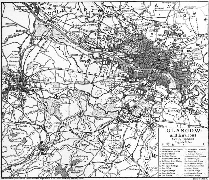
GLASGOW, a city, county of a city, royal burgh and port of Lanarkshire, Scotland, situated on both banks of the Clyde, 401½ m. N.W. of London by the West Coast railway route, and 47 m. W.S.W. of Edinburgh by the North British railway. The valley of the Clyde is closely confined by hills, and the city extends far over these, the irregularity of its site making for picturesqueness. The commercial centre of Glasgow, with the majority of important public buildings, lies on the north bank of the river, which traverses the city from W.S.W. to E.N.E., and is crossed by a number of bridges. The uppermost is Dalmarnock Bridge, dating from 1891, and next below it is Rutherglen Bridge, rebuilt in 1896, and superseding a structure of 1775. St Andrew’s suspension bridge gives access to the Green to the inhabitants of Hutchesontown, a district which is approached also by Albert Bridge, a handsome erection, leading from the Saltmarket. Above this bridge is the tidal dam and weir. Victoria Bridge, of granite, was opened in 1856, taking the place of the venerable bridge erected by Bishop Rae in 1345, which was demolished in 1847. Then follows a suspension bridge (dating from 1853) by which foot-passengers from the south side obtain access to St Enoch Square and, finally, the most important bridge of all is reached, variously known as Glasgow, Jamaica Street, or Broomielaw Bridge, built of granite from Telford’s designs and first used in 1835. Towards the close of the century it was reconstructed, and reopened in 1899. At the busier periods of the day it bears a very heavy traffic. The stream is spanned between Victoria and Albert Bridges by a bridge belonging to the Glasgow & South-Western railway and by two bridges carrying the lines of the Caledonian railway, one below Dalmarnock Bridge and the other a massive work immediately west of Glasgow Bridge.
Buildings.—George Square, in the heart of the city, is an open space of which every possible advantage has been taken. On its eastern side stand the municipal buildings, a palatial pile in Venetian renaissance style, from the designs of William Young, a native of Paisley. They were opened in 1889 and cost nearly £600,000. They form a square block four storeys high and carry a domed turret at each end of the western façade, from the centre of which rises a massive tower. The entrance hall and grand staircase, the council chamber, banqueting hall and reception rooms are decorated in a grandiose style, not unbecoming to the commercial and industrial metropolis of Scotland. Several additional blocks have been built or rented for the accommodation of the municipal staff. Admirably equipped sanitary chambers were opened in 1897, including a bacteriological and chemical laboratory. Up till 1810 the town council met in a hall adjoining the old tolbooth. It then moved to the fine classical structure at the foot of the Saltmarket, which is now used as court-houses. This was vacated in 1842 for the county buildings in Wilson Street. Growth of business compelled another migration to Ingram Street in 1875, and, fourteen years later, it occupied its present quarters. On the southern side of George Square the chief structure is the massive General Post Office. On the western side stand two ornate Italian buildings, the Bank of Scotland and the Merchants’ House, the head of which (the dean of gild), along with the head of the Trades’ House (the deacon-convener of trades) has been de facto member of the town council since 1711, an arrangement devised with a view to adjusting the frequent disputes between the two gilds. The Royal Exchange, a Corinthian building with a fine portico of columns in two rows, is an admired example of the work of David Hamilton (1768-1843), a native of Glasgow, who designed several of the public buildings and churches, and gained the second prize for a design for the Houses of Parliament. The news-room of the exchange is a vast apartment, 130 ft. long, 60 ft. wide, 130 ft. high, with a richly-decorated roof supported by Corinthian pillars. Buchanan Street, the most important and handsome street in the city, contains the Stock Exchange, the Western Club House (by David Hamilton) and the offices of the Glasgow Herald. In Sauchiehall Street are the Fine Art Institute and the former Corporation Art Gallery. Argyll Street, the busiest thoroughfare, mainly occupied with shops, leads to Trongate, where a few remains of the old town are now carefully preserved. On the south side of the street, spanning the pavement, stands the Tron Steeple, a stunted spire dating from 1637. It is all that is left of St Mary’s church, which was burned down in 1793 during the revels of a notorious body known as the Hell Fire Club. On the opposite side, at the corner of High Street, stood the ancient tolbooth, or prison, a turreted building, five storeys high, with a fine Jacobean crown tower. The only remnant of the structure is the tower known as the Cross Steeple.
Although almost all the old public buildings of Glasgow have been swept away, the cathedral remains in excellent preservation. It stands in the north-eastern quarter of the city at a height of 104 ft. above the level of the Clyde. It is a St Mungo’s Cathedral. beautiful example of Early English work, impressive in its simplicity. Its form is that of a Latin cross, with imperfect transepts. Its length from east to west is 319 ft., and its width 63 ft.; the height of the choir is 93 ft., and of the nave 85 ft. At the centre rises a fine tower, with a short octagonal spire, 225 ft. high. The choir, locally known as the High Church, serves as one of the city churches, and the extreme east end of it forms the Lady chapel. The rich western doorway is French in design but English in details. The chapter-house projects from the north-eastern corner and somewhat mars the harmony of the effect. It was built in the 15th century and has a groined roof supported by a pillar 20 ft. high. Many citizens have contributed towards filling the windows with stained glass, executed at Munich, the government providing the eastern window in recognition of their enterprise. The crypt beneath the choir is not the least remarkable part of the edifice, being without equal in Scotland. It is borne on 65 pillars and lighted by 41 windows. The sculpture of the capitals of the columns and bosses of the groined vaulting is exquisite and the whole is in excellent preservation. Strictly speaking, it is not a crypt, but a lower church adapted to the sloping ground of the right bank of the Molendinar burn. The dripping aisle is so named from the constant dropping of water from the roof. St Mungo’s Well in the south-eastern corner was considered to possess therapeutic virtues, and in the crypt a recumbent effigy, headless and handless, is faithfully accepted as the tomb of Kentigern. The cathedral contains few monuments of exceptional merit, but the surrounding graveyard is almost completely paved with tombstones. In 1115 an investigation was ordered by David, prince of Cumbria, into the lands and churches belonging to the bishopric, and from the deed then drawn up it is clear that at that date a cathedral had already been endowed. When David ascended the throne in 1124 he gave to the see of Glasgow the lands of Partick, besides restoring many possessions of which it had been deprived. Jocelin (d. 1199), made bishop in 1174, was the first great bishop, and is memorable for his efforts to replace the cathedral built in 1136 by Bishop John Achaius, which had been destroyed by fire. The crypt is his work, and he began the choir, Lady chapel, and central tower. The new structure was sufficiently advanced to be dedicated in 1197. Other famous bishops were Robert Wishart (d. 1316), appointed in 1272, who was among the first to join in the revolt of Wallace, and received Robert Bruce when he lay under the ban of the church for the murder of Comyn; John Cameron (d. 1446), appointed in 1428, under whom the building as it stands was completed; and William Turnbull (d. 1454), appointed in 1447, who founded the university in 1450. James Beaton or Bethune (1517-1603) was the last Roman Catholic archbishop. He fled to France at the reformation in 1560, and took with him the treasures and records of the see, including the Red Book of Glasgow dating from the reign of Robert III. The documents were deposited in the Scots College in Paris, were sent at the outbreak of the Revolution for safety to St Omer, and were never recovered. This loss explains the paucity of the earlier annals of the city. The zeal of the Reformers led them to threaten to mutilate the cathedral, but the building was saved by the prompt action of the craftsmen, who mustered in force and dispersed the fanatics.
(Click to enlarge.)
Excepting the cathedral, none of the Glasgow churches possesses historical interest; and, speaking generally, it is only the buildings that have been erected since the beginning of the 19th century that have pronounced Churches. architectural merit. This was due largely to the long survival of the severe sentiment of the Covenanters, who discouraged, if they did not actually forbid, the raising of temples of beautiful design. Representative examples of later work are found in the United Free churches in Vincent Street, in Caledonia Road and at Queen’s Park, designed by Alexander Thomson (1817-1875), an architect of distinct originality; St George’s church, in West George Street, a remarkable work by William Stark, erected in the beginning of the 19th century; St Andrew’s church in St Andrew’s Square off the Saltmarket, modelled after St Martin’s-in-the-Fields, London, with a fine Roman portico; some of the older parish churches, such as St Enoch’s, dating from 1780, with a good spire (the saint’s name is said to be a corruption of Tanew, mother of Kentigern); the episcopal church of St Mary (1870), in Great Western Road, by Sir G. G. Scott; the Roman Catholic cathedral of St Andrew, on the river-bank between Victoria and Broomielaw bridges; the Barony church, replacing the older kirk in which Norman Macleod ministered; and several admirable structures, well situated, on the eastern confines of Kelvingrove Park.
The principal burying-ground is the Necropolis, occupying Fir Park, a hill about 300 ft. high in the northern part of the city. It provides a not inappropriate background to the cathedral, from which it is approached by a bridge, known as the “Bridge of Sighs,” over the Molendinar ravine. The ground, which once formed portion of the estate of Wester Craigs, belongs to the Merchants’ House, which purchased it in 1650 from Sir Ludovic Stewart of Minto. A Doric column to the memory of Knox, surmounted by a colossal statue of the reformer, was erected by public subscription on the crown of the height in 1824, and a few years later the idea arose of utilizing the land as a cemetery. The Jews have reserved for their own people a detached area in the north-western corner of the cemetery.
Education.—The university, founded in 1450 by Bishop Turnbull under a bull of Pope Nicholas V., survived in its old quarters till far in the 19th century. The paedagogium, or college of arts, was at first housed in Rottenrow, Glasgow University. but was moved in 1460 to a site in High Street, where Sir James Hamilton of Cadzow, first Lord Hamilton (d. 1479), gave it four acres of land and some buildings. Queen Mary bestowed upon it thirteen acres of contiguous ground, and her son granted it a new charter and enlarged the endowments. Prior to the Revolution its fortunes fluctuated, but in the 18th century it became very famous. By the middle of the 19th century, however, its surroundings had deteriorated, and in 1860 it was decided to rebuild it elsewhere. The ground had enormously increased in value and a railway company purchased it for £100,000. In 1864 the university bought the Gilmore Hill estate for £65,000, the adjacent property of Dowan Hill for £16,000 and the property of Clayslaps for £17,400. Sir G. G. Scott was appointed architect and selected as the site of the university buildings the ridge of Gilmore Hill—the finest situation in Glasgow. The design is Early English with a suggestion in parts of the Scots-French style of a much later period. The main structure is 540 ft. long and 300 ft. broad. The principal front faces southwards and consists of a lofty central tower with spire and corner blocks with turrets, between which are buildings of lower height. Behind the tower lies the Bute hall, built on cloisters, binding together the various departments and smaller halls, and dividing the massive edifice into an eastern and western quadrangle, on two sides of which are ranged the class-rooms in two storeys. The northern façade comprises two corner blocks, besides the museum, the library and, in the centre, the students’ reading-room on one floor and the Hunterian museum on the floor above. On the south the ground falls in terraces towards Kelvingrove Park and the Kelvin. On the west, but apart from the main structure, stand the houses of the principal and professors. The foundation stone was laid in 1868 and the opening ceremony was held in 1870. The total cost of the university buildings amounted to £500,000, towards which government contributed £120,000 and public subscription £250,000. The third marquess of Bute (1847-1900) gave £40,000 to provide the Bute or common hall, a room of fine proportions fitted in Gothic style and divided by a beautiful Gothic screen from the Randolph hall, named after another benefactor, Charles Randolph (1809-1878), a native of Stirling, who had prospered as shipbuilder and marine engineer and left £60,000 to the university. The graceful spire surmounting the tower was provided from the bequest of £5000 by Mr A. Cunningham, deputy town-clerk, and Dr John M’Intyre erected the Students’ Union at a cost of £5000, while other donors completed the equipment so generously that the senate was enabled to carry on its work, for the first time in its history, in almost ideal circumstances. The library includes the collection of Sir William Hamilton, and the Hunterian museum, bequeathed by William Hunter, the anatomist, is particularly rich in coins, medals, black-letter books and anatomical preparations. The observatory on Dowan Hill is attached to the chair of astronomy. An interesting link with the past are the exhibitions founded by John Snell (1629-1679), a native of Colmonell in Ayrshire, for the purpose of enabling students of distinction to continue their career at Balliol College, Oxford. Amongst distinguished exhibitioners have been Adam Smith, John Gibson Lockhart, John Wilson (“Christopher North”), Archbishop Tait, Sir William Hamilton and Professor Shairp. The curriculum of the university embraces the faculties of arts, divinity, medicine, law and science. The governing body includes the chancellor, elected for life by the general council, the principal, also elected for life, and the lord rector elected triennially by the students voting in “nations” according to their birthplace (Glottiana, natives of Lanarkshire; Transforthana, of Scotland north of the Forth; Rothseiana, of the shires of Bute, Renfrew and Ayr; and Loudonia, all others). There are a large number of well-endowed chairs and lectureships and the normal number of students exceeds 2000. The universities of Glasgow and Aberdeen unite to return one member to parliament. Queen Margaret College for women, established in 1883, occupies a handsome building close to the botanic gardens, has an endowment of upwards of £25,000, and was incorporated with the university in 1893. Muirhead College is another institution for women.
Elementary instruction is supplied at numerous board schools. Higher, secondary and technical education is provided at several well-known institutions. There are two educational endowments boards which apply a revenue of about Schools and colleges. £10,000 a year mainly to the foundation of bursaries. Anderson College in George Street perpetuates the memory of its founder, John Anderson (1726-1796), professor of natural philosophy in the university, who opened a class in physics for working men, which he conducted to the end of his life. By his will he provided for an institution for the instruction of artisans and others unable to attend the university. The college which bears his name began in 1796 with lectures on natural philosophy and chemistry by Thomas Garnett (1766-1802). Two years later mathematics and geography were added. In 1799 Dr George Birkbeck (1776-1841) succeeded Garnett and began those lectures on mechanics and applied science which, continued elsewhere, ultimately led to the foundation of mechanics’ institutes in many towns. In later years the college was further endowed and its curriculum enlarged by the inclusion of literature and languages, but ultimately it was determined to limit the scope of its work to medicine (comprising, however, physics, chemistry and botany also). The lectures of its medical school, incorporated in 1887 and situated near the Western Infirmary, are accepted by Glasgow and other universities. The Glasgow and West of Scotland Technical College, formed in 1886 out of a combination of the arts side of Anderson College, the College of Science and Arts, Allan Glen’s Institution and the Atkinson Institution, is subsidized by the corporation and the endowments board, and is especially concerned with students desirous of following an industrial career. St Mungo’s College, which has developed from an extra-mural school in connexion with the Royal Infirmary, was incorporated in 1889, with faculties of medicine and law. The United Free Church College, finely situated near Kelvingrove Park, the School of Art and Design, and the normal schools for the training of teachers, are institutions with distinctly specialized objects.
The High school in Elmbank is the successor of the grammar school (long housed in John Street) which was founded in the 14th century as an appanage of the cathedral. It was placed under the jurisdiction of the school board in 1873. Other secondary schools include Glasgow Academy, Kelvinside Academy and the girls’ and boys’ schools endowed by the Hutcheson trust. Several of the schools under the board are furnished with secondary departments or equipped as science schools, and the Roman Catholics maintain elementary schools and advanced academies.
Art Galleries, Libraries and Museums.—Glasgow merchants and manufacturers alike have been constant patrons of art, and their liberality may have had some influence on the younger painters who, towards the close of the 19th century, broke away from tradition and, stimulated by training in the studios of Paris, became known as the “Glasgow school.” The art gallery and museum in Kelvingrove Park, which was built at a cost of £250,000 (partly derived from the profits of the exhibitions held in the park in 1888 and 1901), is exceptionally well appointed. The collection originated in 1854 in the purchase of the works of art belonging to Archibald M’Lellan, and was supplemented from time to time by numerous bequests of important pictures. It was housed for many years in the Corporation galleries in Sauchiehall Street. The Institute of Fine Arts, in Sauchiehall Street, is mostly devoted to periodical exhibitions of modern art. There are also pictures on exhibition in the People’s Palace on Glasgow Green, which was built by the corporation in 1898 and combines an art gallery and museum with a conservatory and winter garden, and in the museum at Camphill, situated within the bounds of Queen’s Park. The library and Hunterian museum in the university are mostly reserved for the use of students. The faculty of procurators possess a valuable library which is housed in their hall, an Italian Renaissance building, in West George Street. In Bath Street there are the Mechanics’ and the Philosophical Society’s libraries, and the Physicians’ is in St Vincent Street. Miller Street contains the headquarters of the public libraries. The premises once occupied by the water commission have been converted to house the Mitchell library, which grew out of a bequest of £70,000 by Stephen Mitchell, largely reinforced by further gifts of libraries and funds, and now contains upwards of 100,000 volumes. It is governed by the city council and has been in use since 1877. Another building in this street accommodates both the Stirling and Baillie libraries. The Stirling, with some 50,000 volumes, is particularly rich in tracts of the 16th and 17th centuries, and the Baillie was endowed by George Baillie, a solicitor who, in 1863, gave £18,000 for educational objects. The Athenaeum in St George’s Place, an institution largely concerned with evening classes in various subjects, contains an excellent library and reading-room.
Charities.—The old Royal Infirmary, designed by Robert Adam and opened in 1794, adjoining the cathedral, occupies the site of the archiepiscopal palace, the last portion of which was removed towards the close of the 18th century. The chief architectural feature of the infirmary is the central dome forming the roof of the operating theatre. On the northern side are the buildings of the medical school attached to the institution. The new infirmary commemorates the Diamond Jubilee of Queen Victoria. A little farther north, in Castle Street, is the blind asylum. The Western Infirmary is to some extent used for the purposes of clinical instruction in connexion with the university, to which it stands in immediate proximity. Near it is the Royal hospital for sick children. To the south of Queen’s Park is Victoria Infirmary, and close to it the deaf and dumb institution. On the bank of the river, not far from the south-eastern boundary of the city, is the Belvedere hospital for infectious diseases, and at Ruchill, in the north, is another hospital of the same character opened in 1900. The Royal asylum at Gartnavel is situated near Jordanhill station, and the District asylum at Gartloch (with a branch at West Muckroft) lies in the parish of Cadder beyond the north-eastern boundary. There are numerous hospitals exclusively devoted to the treatment of special diseases, and several nursing institutions and homes. Hutcheson’s Hospital, designed by David Hamilton and adorned with statues of the founders, is situated in Ingram Street, and by the increase in the value of its lands has become a very wealthy body. George Hutcheson (1580-1639), a lawyer in the Trongate near the tolbooth, who afterwards lived in the Bishop’s castle, which stood close to the spot where the Kelvin enters the Clyde, founded the hospital for poor old men. His brother Thomas (1589-1641) established in connexion with it a school for the lodging and education of orphan boys, the sons of burgesses. The trust, through the growth of its funds, has been enabled to extend its educational scope and to subsidize schools apart from the charity.
Monuments.—Most of the statues have been erected in George Square. They are grouped around a fluted pillar 80 ft. high, surmounted by a colossal statue of Sir Walter Scott by John Ritchie (1809-1850), erected in 1837, and include Queen Victoria and the Prince Consort (both equestrian) by Baron Marochetti; James Watt by Chantrey; Sir Robert Peel, Thomas Campbell the poet, who was born in Glasgow, and David Livingstone, all by John Mossman; Sir John Moore, a native of Glasgow, by Flaxman, erected in 1819; James Oswald, the first member returned to parliament for the city after the Reform Act of 1832; Lord Clyde (Sir Colin Campbell), also a native, by Foley, erected in 1868; Dr Thomas Graham, master of the mint, another native, by Brodie; Robert Burns by G. E. Ewing, erected in 1877, subscribed for in shillings by the working men of Scotland; and William Ewart Gladstone by Hamo Thornycroft, unveiled by Lord Rosebery in 1902. In front of the Royal Exchange stands the equestrian monument of the duke of Wellington. In Cathedral Square are the statues of Norman Macleod, James White and James Arthur, and in front of the Royal infirmary is that of Sir James Lumsden, lord provost and benefactor. Nelson is commemorated by an obelisk 143 ft. high on the Green, which was erected in 1806 and is said to be a copy of that in the Piazza del Popolo at Rome. One of the most familiar statues is the equestrian figure of William III. in the Trongate, which was presented to the town in 1735 by James Macrae (1677-1744), a poor Ayrshire lad who had amassed a fortune in India, where he was governor of Madras from 1725 to 1730.
Recreations.—Of the theatres the chief are the King’s in Bath Street, the Royal and the Grand in Cowcaddens, the Royalty and Gaiety in Sauchiehall Street, and the Princess’s in Main Street. Variety theatres, headed by the Empire in Sauchiehall Street, are found in various parts of the town. There is a circus in Waterloo Street, a hippodrome in Sauchiehall Street and a zoological garden in New City Road. The principal concert halls are the great hall of the St Andrew’s Halls, a group of rooms belonging to the corporation; the City Hall in Candleriggs, the People’s Palace on the Green, and Queen’s Rooms close to Kelvingrove Park. Throughout winter enormous crowds throng the football grounds of the Queen’s Park, the leading amateur club, and the Celtic, the Rangers, the Third Lanark and other prominent professional clubs.
Parks and Open Spaces.—The oldest open space is the Green (140 acres), on the right bank of the river, adjoining a densely-populated district. It once extended farther west, but a portion was built over at a time when public rights were not vigilantly guarded. It is a favourite area for popular demonstrations, and sections have been reserved for recreation or laid out in flower-beds. Kelvingrove Park, in the west end, has exceptional advantages, for the Kelvin burn flows through it and the ground is naturally terraced, while the situation is beautified by the adjoining Gilmore Hill with the university on its summit. The park was laid out under the direction of Sir Joseph Paxton, and contains the Stewart fountain, erected to commemorate the labours of Lord Provost Stewart and his colleagues in the promotion of the Loch Katrine water scheme. The other parks on the right bank are, in the north, Ruchill (53 acres), acquired in 1891, and Springburn (53¼ acres), acquired in 1892, and, in the east, Alexandra Park (120 acres), in which is laid down a nine-hole golf-course, and Tollcross (82¾ acres), beyond the municipal boundary, acquired in 1897. On the left bank Queen’s Park (130 acres), occupying a commanding site, was laid out by Sir Joseph Paxton, and considerably enlarged in 1894 by the enclosure of the grounds of Camphill. The other southern parks are Richmond (44 acres), acquired in 1898, and named after Lord Provost Sir David Richmond, who opened it in 1899; Maxwell, which was taken over on the annexation of Pollokshields in 1891; Bellahouston (176 acres), acquired in 1895; and Cathkin Braes (50 acres), 3½m. beyond the south-eastern boundary, presented to the city in 1886 by James Dick, a manufacturer, containing “Queen Mary’s stone,” a point which commands a view of the lower valley of the Clyde. In the north-western district of the town 40 acres between Great Western Road and the Kelvin are devoted to the Royal Botanic Gardens, which became public property in 1891. They are beautifully laid out, and contain a great range of hothouses. The gardens owed much to Sir William Hooker, who was regius professor of botany in Glasgow University before his appointment to the directorship of Kew Gardens.
Communications.—The North British railway terminus is situated in Queen Street, and consists of a high-level station (main line) and a low-level station, used in connexion with the City & District line, largely underground, serving the northern side of the town, opened in 1886. The Great Northern and North-Eastern railways use the high-level line of the N.B.R., the three companies forming the East Coast Joint Service. The Central terminus of the Caledonian railway in Gordon Street, served by the West Coast system (in which the London & North-Western railway shares), also comprises a high-level station for the main line traffic and a low-level station for the Cathcart District railway, completed in 1886 and made circular for the southern side and suburbs in 1894, and also for the connexion between Maryhill and Rutherglen, which is mostly underground. Both the underground lines communicate with certain branches of the main line, either directly or by change of carriage. The older terminus of the Caledonian railway in Buchanan Street now takes the northern and eastern traffic. The terminus of the Glasgow & South-Western railway company in St Enoch Square serves the country indicated in its title, and also gives the Midland railway of England access to the west coast and Glasgow. The Glasgow Subway—an underground cable passenger line, 6½ m. long, worked in two tunnels and passing below the Clyde twice—was opened in 1896. Since no more bridge-building will be sanctioned west of the railway bridge at the Broomielaw, there are at certain points steam ferry boats or floating bridges for conveying vehicles across the harbour, and at Stobcross there is a subway for foot and wheeled traffic. Steamers, carrying both goods and passengers, constantly leave the Broomielaw quay for the piers and ports on the river and firth, and the islands and sea lochs of Argyllshire. The city is admirably served by tramways which penetrate every populous district and cross the river by Glasgow and Albert bridges.
Trade.—Natural causes, such as proximity to the richest field of coal and ironstone in Scotland and the vicinity of hill streams of pure water, account for much of the great development of trade in Glasgow. It was in textiles that the city showed its earliest predominance, which, however, has not been maintained, owing, it is alleged, to the shortage of female labour. Several cotton mills are still worked, but the leading feature in the trade has always been the manufacture of such light textures as plain, striped and figured muslins, ginghams and fancy fabrics. Thread is made on a considerable scale, but jute and silk are of comparatively little importance. The principal varieties of carpets are woven. Some factories are exclusively devoted to the making of lace curtains. The allied industries of bleaching, printing and dyeing, on the other hand, have never declined. The use of chlorine in bleaching was first introduced in Great Britain at Glasgow in 1787, on the suggestion of James Watt, whose father-in-law was a bleacher; and it was a Glasgow bleacher, Charles Tennant, who first discovered and made bleaching powder (chloride of lime). Turkey-red dyeing was begun at Glasgow by David Dale and George M‘Intosh, and the colour was long known locally as Dale’s red. A large quantity of grey cloth continues to be sent from Lancashire and other mills to be bleached and printed in Scottish works. These industries gave a powerful impetus to the manufacture of chemicals, and the works at St Rollox developed rapidly. Among prominent chemical industries are to be reckoned the alkali trades—including soda, bleaching powder and soap-making—the preparation of alum and prussiates of potash, bichromate of potash, white lead and other pigments, dynamite and gunpowder. Glass-making and paper-making are also carried on, and there are several breweries and distilleries, besides factories for the making of aerated waters, starch, dextrine and matches. Many miscellaneous trades flourish, such as clothing, confectionery, cabinet-making, bread and biscuit making, boot and shoe making, flour mills and saw mills, pottery and india-rubber. Since the days of the brothers Robert Foulis (1705-1776) and Andrew Foulis (1712-1775), printing, both letterpress and colour, has been identified with Glasgow, though in a lesser degree than with Edinburgh. The tobacco trade still flourishes, though much lessened. But the great industry is iron-founding. The discovery of the value of blackband ironstone, till then regarded as useless “wild coal,” by David Mushet (1772-1847), and Neilson’s invention of the hot-air blast threw the control of the Scottish iron trade into the hands of Glasgow ironmasters, although the furnaces themselves were mostly erected in Lanarkshire and Ayrshire. The expansion of the industry was such that, in 1859, one-third of the total output in the United Kingdom was Scottish. During the following years, however, the trade seemed to have lost its elasticity, the annual production averaging about one million tons of pig-iron. Mild steel is manufactured extensively, and some crucible cast steel is made. In addition to brass foundries there are works for the extraction of copper and the smelting of lead and zinc. With such resources every branch of engineering is well represented. Locomotive engines are built for every country where railways are employed, and all kinds of builder’s ironwork is forged in enormous quantities, and the sewing-machine factories in the neighbourhood are important. Boiler-making and marine engine works, in many cases in direct connexion with the shipbuilding yards, are numerous. Shipbuilding, indeed, is the greatest of the industries of Glasgow, and in some years more than half of the total tonnage in the United Kingdom has been launched on the Clyde, the yards of which extend from the harbour to Dumbarton on one side and Greenock on the other side of the river and firth. Excepting a trifling proportion of wooden ships, the Clyde-built vessels are of iron and steel, the trade having owed its immense expansion to the prompt adoption of this material. Every variety of craft is turned out, from battleships and great liners to dredging-plant and hopper barges.
The Port.—The harbour extends from Glasgow Bridge to the point where the Kelvin joins the Clyde, and occupies 206 acres. For the most part it is lined by quays and wharves, which have a total length of 8¼ m., and from the harbour to the sea vessels drawing 26 ft. can go up or down on one tide. It is curious to remember that in the middle of the 18th century the river was fordable on foot at Dumbuck, 12 m. below Glasgow and 1½ m. S.E. of Dumbarton. Even within the limits of the present harbour Smeaton reported to the town council in 1740 that at Pointhouse ford, just east of the mouth of the Kelvin, the depth at low water was only 15 in. and at high water 39 in. The transformation effected within a century and a half is due to the energy and enterprise of the Clyde Navigation Trust. The earliest shipping-port of Glasgow was Irvine in Ayrshire, but lighterage was tedious and land carriage costly, and in 1658 the civic authorities endeavoured to purchase a site for a spacious harbour at Dumbarton. Being thwarted by the magistrates of that burgh, however, in 1662 they secured 13 acres on the southern bank at a spot some 2 m. above Greenock, which became known as Port Glasgow, where they built harbours and constructed the first graving dock in Scotland. Sixteen years later the Broomielaw quay was built, but it was not until the tobacco merchants appreciated the necessity of bringing their wares into the heart of the city that serious consideration was paid to schemes for deepening the waterway. Smeaton’s suggestion of a lock and dam 4 m. below the Broomielaw was happily not accepted. In 1768 John Golborne advised the narrowing of the river and the increasing of the scour by the construction of rubble jetties and the dredging of sandbanks and shoals. After James Watt’s report in 1769 on the ford at Dumbuck, Golborne succeeded in 1775 in deepening the ford to 6 ft. at low water with a width of 300 ft. By Rennie’s advice in 1799, following up Golborne’s recommendation, as many as 200 jetties were built between Glasgow and Bowling, some old ones were shortened and low rubble walls carried from point to point of the jetties, and thus the channel was made more uniform and much land reclaimed. By 1836 there was a depth of 7 or 8 ft. at the Broomielaw at low water, and in 1840 the whole duty of improving the navigation was devolved upon the Navigation Trust. Steam dredgers were kept constantly at work, shoals were removed and rocks blasted away. Two million cubic yards of matter are lifted every year and dumped in Loch Long. By 1900 the channel had been deepened to a minimum of 22 ft., and, as already indicated, the largest vessels make the open sea in one tide, whereas in 1840 it took ships drawing only 15 ft. two and even three tides to reach the sea. The debt of the Trust amounts to £6,000,000, and the annual revenue to £450,000. Long before these great results had been achieved, however, the shipping trade had been revolutionized by the application of steam to navigation, and later by the use of iron for wood in shipbuilding, in both respects enormously enhancing the industry and commerce of Glasgow. From 1812 to 1820 Henry Bell’s “Comet,” 30 tons, driven by an engine of 3 horse-power, plied between Glasgow and Greenock, until she was wrecked, being the first steamer to run regularly on any river in the Old World. Thus since the appearance of that primitive vessel phenomenal changes had taken place on the Clyde. When the quays and wharves ceased to be able to accommodate the growing traffic, the construction of docks became imperative. In 1867 Kingston Dock on the south side, of 51⁄3 acres, was opened, but soon proved inadequate, and in 1880 Queen’s Dock (two basins) at Stobcross, on the north side, of 30 acres, was completed. Although this could accommodate one million tons of shipping, more dock space was speedily called for, and in 1897 Prince’s Dock (three basins) on the opposite side, of 72 acres, was opened, fully equipped with hydraulic and steam cranes and all the other latest appliances. There are, besides, three graving docks, the longest of which (880 ft.) can be made at will into two docks of 417 ft. and 457 ft. in length. The Caledonian and Glasgow & South-Western railways have access to the harbour for goods and minerals at Terminus Quay to the west of Kingston Dock, and a mineral dock has been constructed by the Trust at Clydebank, about 3½ m. below the harbour. The shipping attains to colossal proportions. The imports consist chiefly of flour, fruit, timber, iron ore, live stock and wheat; and the exports principally of cotton manufactures, manufactured iron and steel, machinery, whisky, cotton yarn, linen fabrics, coal, jute, jam and foods, and woollen manufactures.