VOLUME XI SLICE VI Geodesy to Geometry (continued 3)
Reading edition
The reign of Elizabeth is famous for the gallant enterprises that were undertaken by sea and land to discover and bring to light the unknown parts of the earth. The great promoter of geographical discovery in the Elizabethan period was The Elizabethan era. Richard Hakluyt (1553-1616), who was active in the formation of the two companies for colonizing Virginia in 1606; and devoted his life to encouraging and recording similar undertakings. He published much, and left many valuable papers at his death, most of which, together with many other narratives, were published in 1622 in the great work of the Rev. Samuel Purchas, entitled Hakluytus Posthumus, or Purchas his Pilgrimes.
It is from these works that our knowledge of the gallant deeds of the English and other explorers of the Elizabethan age is mainly derived. The great and splendidly illustrated collections of voyages and travels of Theodorus de Bry and Hulsius served a similar useful purpose on the continent of Europe. One important object of English maritime adventurers of those days was to discover a route to Cathay by the north-west, a second was to settle Virginia, and a third was to raid the Spanish settlements in the West Indies. Nor was the trade to Muscovy and Turkey neglected; while latterly a resolute and successful attempt was made to establish direct commercial relations with India.
The conception of the north-western route to Cathay now leads the story of exploration, for the first time as far as important and sustained efforts are concerned, towards the Arctic seas. This part of the story is fully told under the heading of Polar Regions, and only the names of Martin Frobisher (1576), John Davis (1585), Henry Hudson (1607) and William Baffin (1616) need be mentioned here in order to preserve the complete conspectus of the history of discovery. The Dutch emulated the British in the Arctic seas during this period, directing their efforts mainly towards the discovery of a north-east passage round the northern end of Novaya Zemlya; and William Barents or Barendsz (1594-1597) is the most famous name in this connexion, his boat voyage along the coast of Novaya Zemlya after losing his ship and wintering in a high latitude, being one of the most remarkable achievements in polar annals.
Many English voyages were also made to Guinea and the West Indies, and twice English vessels followed in the track of Magellan, and circumnavigated the globe. In 1577 Francis Drake, who had previously served with Hawkins in the West Indies, undertook his celebrated voyage round the world. Reaching the Pacific through the Strait of Magellan, Drake proceeded northward along the west coast of America, resolved to attempt the discovery of a northern passage from the Pacific to the Atlantic. The coast from the southern extremity of the Californian peninsula to Cape Mendocino had been discovered by Juan Rodriguez Cabrillo and Francisco de Ulloa in 1539. Drake’s discoveries extended from Cape Mendocino to 48° N., in which latitude he gave up his quest, sailed across the Pacific and reached the Philippine Islands, returning home round the Cape of Good Hope in 1580.
Thomas Cavendish, emulous of Drake’s example, fitted out three vessels for an expedition to the South sea in 1586. He took the same route as Drake along the west coast of America. From Cape San Lucas Cavendish steered across the Pacific, seeing no land until he reached the Ladrone Islands. He returned to England in 1588. The third English voyage into the Pacific was not so fortunate. Sir Richard Hawkins (1593) on reaching the bay of Atacames, in 1°N. in 1594, was attacked by a Spanish fleet, and, after a desperate naval engagement, was forced to surrender. Hawkins declared his object to be discovery and the survey of unknown lands, and his voyage, though terminating in disaster, bore good fruit. The Observations of Sir Richard Hawkins in his Voyage into the South Sea, published in 1622, are very valuable. It was long before another British ship entered the Pacific Ocean. Sir John Narborough took two ships through the Strait of Magellan in 1670 and touched on the coast of Chile, but it was not until 1685 that Dampier sailed over the part of the Pacific where Hawkins met his defeat.
The exploring enterprise of the Spanish nation did not wane after the conquest of Peru and Mexico, and the acquisition of the vast empire of the Indies. It was spurred into renewed activity by the audacity of Sir John Hawkins in the West Indies, and by the appearance of Drake, Cavendish and Richard Hawkins in the Pacific.
In the interior of South America the Spanish conquerors had explored the region of the Andes from the isthmus of Panama to Chile. Pedro de Valdivia in 1540 made an expedition into the country of the Araucanian Indians of Chile, and was the first to explore the eastern base of the Andes in what is now Argentine Patagonia. In 1541 Francisco de Orellana discovered the whole course of the Amazon from its source in the Andes to the Atlantic. A second voyage on the Amazon was made in 1561 by the mad pirate Lope de Aguirre; but it was not until 1639 that a full account was written of the great river by Father Cristoval de Acuña, who ascended it from its mouth and reached the city of Quito.
The voyage of Drake across the Pacific was preceded by that of Alvaro de Mendaña, who was despatched from Peru in 1567 to discover the great Antarctic continent which was believed to extend far northward into the South sea, the search Spaniards in the Pacific. for which now became one of the leading motives of exploration. After a voyage of eighty days across the Pacific, Mendaña discovered the Solomon Islands; and the expedition returned in safety to Callao. The appearance of Drake on the Peruvian coast led to an expedition being fitted out at Callao, to go in chase of him, under the command of Pedro Sarmiento. He sailed from Callao in October 1579, and made a careful survey of the Strait of Magellan, with the object of fortifying that entrance to the South sea. The colony which he afterwards took out from Spain was a complete failure, and is only remembered now from the name of “Port Famine,” which Cavendish gave to the site at which he found the starving remnant of Sarmiento’s settlers. In June 1595 Mendaña sailed from the coast of Peru in command of a second expedition to colonize the Solomon Islands. After discovering the Marquesas, he reached the island of Santa Cruz of evil memory, where he and many of the settlers died. His young widow took command of the survivors and brought them safely to Manila. The viceroys of Peru still persevered in their attempts to plant a colony in the hypothetical southern continent. Pedro Fernandez de Quiros, who was pilot under Mendaña and Luis Vaez de Torres, were sent in command of two ships to continue the work of exploration. They sailed from Callao in December 1605, and discovered several islands of the New Hebrides group. They anchored in a bay of a large island which Quiros named “Australia del Espiritu Santo.” From this place Quiros returned to America, but Torres continued the voyage, passed through the strait between Australia and New Guinea which bears his name, and explored and mapped the southern and eastern coasts of New Guinea.
The Portuguese, in the early part of the 17th century (1578-1640), were under the dominion of Spain, and their enterprise was to some extent damped; but their missionaries extended geographical knowledge in Africa. Father Francisco Paez acquired great influence in Abyssinia, and explored its highlands from 1600 to 1622. Fathers Mendez and Lobo traversed the deserts between the coast of the Red sea and the mountains, became acquainted with Lake Tsana, and discovered the sources of the Blue Nile in 1624-1633.
But the attention of the Portuguese was mainly devoted to vain attempts to maintain their monopoly of the trade of India against the powerful rivalry of the English and Dutch. The English enterprises were persevering, continuous and Rivalry in the East. successful. James Lancaster made a voyage to the Indian Ocean from 1591 to 1594; and in 1599 the merchants and adventurers of London resolved to form a company, with the object of establishing a trade with the East Indies. On the 31st of December 1599 Queen Elizabeth granted the charter of incorporation to the East India Company, and Sir James Lancaster, one of the directors, was appointed general of their first fleet. He was accompanied by John Davis, the great Arctic navigator, as pilot-major. This voyage was eminently successful. The ships touched at Achin in Sumatra and at Java, returning with full ladings of pepper in 1603. The second voyage was commanded by Sir Henry Middleton; but it was in the third voyage, under Keelinge and Hawkins, that the mainland of India was first reached in 1607. Captain Hawkins landed at Surat and travelled overland to Agra, passing some time at the court of the Great Mogul. In the voyage of Sir Edward Michelborne in 1605, John Davis lost his life in a fight with a Japanese junk. The eighth voyage, led by Captain Saris, extended the operations of the company to Japan; and in 1613 the Japanese government granted privileges to the company; but the British retired in 1623, giving up their factory. The chief result of this early intercourse between Great Britain and Japan was the interesting series of letters written by William Adams from 1611 to 1617. From the tenth voyage of the East India Company, commanded by Captain Best, who left England in 1612, dates the establishment of permanent British factories on the coast of India. It was Captain Best who secured a regular firman for trade from the Great Mogul. From that time a fleet was despatched every year, and the company’s operations greatly increased geographical knowledge of India and the Eastern Archipelago. British visits to Eastern countries, at this time, were not confined to the voyages of the company. Journeys were also made by land, and, among others, the entertaining author of the Crudities, Thomas Coryate, of Odcombe in Somersetshire, wandered on foot from France to India, and died (1617) in the company’s factory at Surat. In 1561 Anthony Jenkinson arrived in Persia with a letter from Queen Elizabeth to the shah. He travelled through Russia to Bokhara, and returned by the Caspian and Volga. In 1579 Christopher Burroughs built a ship at Nizhniy Novgorod and traded across the Caspian to Baku; and in 1598 Sir Anthony and Robert Shirley arrived in Persia, and Robert was afterwards sent by the shah to Europe as his ambassador. He was followed by a Spanish mission under Garcia de Silva, who wrote an interesting account of his travels; and to Sir Dormer Cotton’s mission, in 1628, we are indebted for Sir Thomas Herbert’s charming narrative. In like manner Sir Thomas Roe’s mission to India resulted not only in a large collection of valuable reports and letters of his own, but also in the detailed account of his chaplain Terry. But the most learned and intelligent traveller in the East, during the 17th century, was the German, Engelbrecht Kaempfer, who accompanied an embassy to Persia, in 1684, and was afterwards a surgeon in the service of the Dutch East India Company. He was in the Persian Gulf, India and Java, and resided for more than two years in Japan, of which he wrote a history.
The Dutch nation, as soon as it was emancipated from Spanish tyranny, displayed an amount of enterprise, which, for a long time, was fully equal to that of the British. The Arctic voyages of Barents were quickly followed by the establishment of Dutch exploration, 16th-17th centuries. a Dutch East India Company; and the Dutch, ousting the Portuguese, not only established factories on the mainland of India and in Japan, but acquired a preponderating influence throughout the Malay Archipelago. In 1583 Jan Hugen van Linschoten made a voyage to India with a Portuguese fleet, and his full and graphic descriptions of India, Africa, China and the Malay Archipelago must have been of no small use to his countrymen in their distant voyages. The first of the Dutch Indian voyages was performed by ships which sailed in April 1595, and rounded the Cape of Good Hope. A second large Dutch fleet sailed in 1598; and, so eager was the republic to extend her commerce over the world that another fleet, consisting of five ships of Rotterdam, was sent in the same year by way of Magellan’s Strait, under Jacob Mahu as admiral, with William Adams as pilot. Mahu died on the passage out, and was succeeded by Simon de Cordes, who was killed on the coast of Chile. In September 1599 the fleet had entered the Pacific. The ships were then steered direct for Japan, and anchored off Bungo in April 1600. In the same year, 1598, a third expedition was despatched under Oliver van Noort, a native of Utrecht, but the voyage contributed nothing to geography. The Dutch Company in 1614 again resolved to send a fleet to the Moluccas by the westward route, and Joris Spilbergen was appointed to the command as admiral, with a commission from the States-General. He was furnished with four ships of Amsterdam, two of Rotterdam and one from Zeeland. On the 6th of May 1615 Spilbergen entered the Pacific Ocean, and touched at several places on the coast of Chile and Peru, defeating the Spanish fleet in a naval engagement off Chilca. After plundering Payta and making requisitions at Acapulco, the Dutch fleet crossed the Pacific and reached the Moluccas in March 1616.
The Dutch now resolved to discover a passage into the Pacific to the south of Tierra del Fuego, the insular nature of which had been ascertained by Sir Francis Drake. The vessels fitted out for this purpose were the “Eendracht,” of 360 tons, commanded by Jacob Lemaire, and the “Hoorn,” of 110 tons, under Willem Schouten. They sailed from the Texel on the 14th of June 1615, and by the 20th of January 1616 they were south of the entrance of Magellan’s Strait. Passing through the strait of Lemaire they came to the southern extremity of Tierra del Fuego, which was named Cape Horn, in honour of the town of Hoorn in West Friesland, of which Schouten was a native. They passed the cape on the 31st of January, encountering the usual westerly winds. The great merit of this discovery of a second passage into the South sea lies in the fact that it was not accidental or unforeseen, but was due to the sagacity of those who designed the voyage. On the 1st of March the Dutch fleet sighted the island of Juan Fernandez; and, having crossed the Pacific, the explorers sailed along the north coast of New Guinea and arrived at the Moluccas on the 17th of September 1616.
There were several early indications of the existence of the great Australian continent, and the Dutch endeavoured to obtain further knowledge concerning the country and its extent; but only its northern and western coasts had been visited before the time of Governor van Diemen. Dirk Hartog had been on the west coast in latitude 26° 30′ S. in 1616. Pelsert struck on a reef called “Houtman’s Abrolhos” on the 4th of June 1629. In 1697 the Dutch captain Vlamingh landed on the west coast of Australia, then called New Holland, in 31° 43′ S., and named the Swan river from the black swans he discovered there. In 1642 the governor and council of Batavia fitted out two ships to prosecute the discovery of the south land, then believed to be part of a vast Antarctic continent, and entrusted the command to Captain Abel Jansen Tasman. This voyage proved to be the most important to geography that had been undertaken since the first circumnavigation of the globe. Tasman sailed from Batavia in 1642, and on the 24th of November sighted high land in 42° 30′ S., which was named van Diemen’s Land, and after landing there proceeded to the discovery of the western coast of New Zealand; at first called Staten Land, and supposed to be connected with the Antarctic continent from which this voyage proved New Holland to be separated. He then reached Tongatabu, one of the Friendly Islands of Cook; and returned by the north coast of New Guinea to Batavia. In 1644 Tasman made a second voyage to effect a fuller discovery of New Guinea.
The French directed their enterprise more in the direction of North America than of the Indies. One of their most distinguished explorers was Samuel Champlain, a captain in the navy, French in North America. who, after a remarkable journey through Mexico and the West Indies from 1599 to 1602, established his historic connexion with Canada, to the geographical knowledge of which he made a very large addition.
The principles and methods of surveying and position finding had by this time become well advanced, and the most remarkable example of the early application of these improvements is to be found in the survey of China by Jesuit missionaries. Missionaries in the East. They first prepared a map of the country round Peking, which was submitted to the emperor Kang-hi, and, being satisfied with the accuracy of the European method of surveying, he resolved to have a survey made of the whole empire on the same principles. This great work was begun in July 1708, and the completed maps were presented to the emperor in 1718. The records preserved in each city were examined, topographical information was diligently collected, and the Jesuit fathers checked their triangulation by meridian altitudes of the sun and pole star and by a system of remeasurements. The result was a more accurate map of China than existed, at that time, of any country in Europe. Kang-hi next ordered a similar map to be made of Tibet, the survey being executed by two lamas who were carefully trained as surveyors by the Jesuits at Peking. From these surveys were constructed the well-known maps which were forwarded to Duhalde, and which D’Anville utilized for his atlas.
Several European missionaries had previously found their way from India to Tibet. Antonio Andrada, in 1624, was the first European to enter Tibet since the visit of Friar Odoric The 18th century. in 1325. The next journey was that of Fathers Grueber and Dorville about 1660, who succeeded in passing from China, through Tibet, into India. In 1715 Fathers Desideri and Freyre made their way from Agra, across the Himalayas, to Lhasa, and the Capuchin Friar Orazio della Penna resided in that city from 1735 until 1747. But the most remarkable journey in this direction was performed by a Dutch traveller named Samuel van de Putte. He left Holland in 1718, went by land through Persia to India, and eventually made his way to Lhasa, where he resided for a long time. He went thence to China, returned to Lhasa, and was in India in time to be an eye-witness of the sack of Delhi by Nadir Asia. Shah in 1737. In 1743 he left India and died at Batavia on the 27th of September 1745. The premature death of this illustrious traveller is the more to be lamented because his vast knowledge died with him. Two English missions sent by Warren Hastings to Tibet, one led by George Bogle in 1774, and the other by Captain Turner in 1783, complete Tibetan exploration in the 18th century.
From Persia much new information was supplied by Jean Chardin, Jean Tavernier, Charles Hamilton, Jean de Thévenot and Father Jude Krusinski, and by English traders on the Caspian. In 1738 John Elton traded between Astrakhan and the Persian port of Enzelî on the Caspian, and undertook to build a fleet for Nadir Shah. Another English merchant, named Jonas Hanway, arrived at Astrabad from Russia, and travelled to the camp of Nadir at Kazvin. One lasting and valuable result of Hanway’s wanderings was a charming book of travels. In 1700 Guillaume Delisle published his map of the continents of the Old World; and his successor D’Anville produced his map of India in 1752. D’Anville’s map contained all that was then known, but ten years afterwards Major Rennell began his surveying labours, which extended over the period from 1763 to 1782. His survey covered an area 900 m. long by 300 wide, from the eastern confines of Bengal to Agra, and from the Himalayas to Calpi. Rennell was indefatigable in collecting geographical information; his Bengal atlas appeared in 1781, his famous map of India in 1788 and the memoir in 1792. Surveys were also made along the Indian coasts.
Arabia received very careful attention, in the 18th century, from the Danish scientific mission, which included Carsten Niebuhr among its members. Niebuhr landed at Loheia, on the coast of Yemen, in December 1762, and went by land to Sana. All the other members of the mission died, but he proceeded from Mokha to Bombay. He then made a journey through Persia and Syria to Constantinople, returning to Copenhagen in 1767. His valuable work, the Description of Arabia, was published in 1772, and was followed in 1774-1778 by two volumes of travels in Asia. The great traveller survived until 1815, when he died at the age of eighty-two.
James Bruce of Kinnaird, the contemporary of Niebuhr, was equally devoted to Eastern travel; and his principal geographical work was the tracing of the Blue Nile from its source to its junction with the White Nile. Before the death of Africa. Bruce an African Association was formed, in 1788, for collecting information respecting the interior of that continent, with Major Rennell and Sir Joseph Banks as leading members. The association first employed John Ledyard (who had previously made an extraordinary journey into Siberia) to cross Africa from east to west on the parallel of the Niger, and William Lucas to cross the Sahara to Fezzan. Lucas went from Tripoli to Mesurata, obtained some information respecting Fezzan and returned in 1789. One of the chief problems the association wished to solve was that of the existence and course of the river Niger, which was believed by some authorities to be identical with the Congo. Mungo Park, then an assistant surgeon of an Indiaman, volunteered his services, which were accepted by the association, and in 1795 he succeeded in reaching the town of Segu on the Niger, but was prevented from continuing his journey to Timbuktu. Five years later he accepted an offer from the government to command an expedition into the interior of Africa, the plan being to cross from the Gambia to the Niger and descend the latter river to the sea. After losing most of his companions he himself and the rest perished in a rapid on the Niger at Busa, having been attacked from the shore by order of a chief who thought he had not received suitable presents. His work, however, had established the fact that the Niger was not identical with the Congo.
While the British were at work in the direction of the Niger, the Portuguese were not unmindful of their old exploring fame. In 1798 Dr F.J.M. de Lacerda, an accomplished astronomer, was appointed to command a scientific expedition of discovery to the north of the Zambesi. He started in July, crossed the Muchenja Mountains, and reached the capital of the Cazembe, where he died of fever. Lacerda left a valuable record of his adventurous journey; but with Mungo Park and Lacerda the history of African exploration in the 18th century closes.
In South America scientific exploration was active during this period. The great geographical event of the century, as regards that continent, was the measurement of an arc of the meridian. The undertaking was proposed by the French South America. Academy as part of an investigation with the object of ascertaining the length of the degree near the equator and near the pole respectively so as to determine the figure of the earth. A commission left Paris in 1735, consisting of Charles Marie de la Condamine, Pierre Bouguer, Louis Godin and Joseph de Jussieu the naturalist. Spain appointed two accomplished naval officers, the brothers Ulloa, as coadjutors. The operations were carried on during eight years on a plain to the south of Quito; and, in addition to his memoir on this memorable measurement, La Condamine collected much valuable geographical information during a voyage down the Amazon. The arc measured was 3° 7′ 3″ in length; and the work consisted of two measured bases connected by a series of triangles, one north and the other south of the equator, on the meridian of Quito. Contemporaneously, in 1738, Pierre Louis Moreau de Maupertuis, Alexis Claude Clairaut, Charles Etienne Louis Camus, Pierre Charles Lemonnier and the Swedish physicist Celsius measured an arc of the meridian in Lapland.
The British and French governments despatched several expeditions of discovery into the Pacific and round the world during the 18th century. They were preceded by the wonderful and romantic voyages of the buccaneers. The narratives The Pacific Ocean. of such men as Woodes Rogers, Edward Davis, George Shelvocke, Clipperton and William Dampier, can never fail to interest, while they are not without geographical value. The works of Dampier are especially valuable, and the narratives of William Funnell and Lionel Wafer furnished the best accounts then extant of the Isthmus of Darien. Dampier’s literary ability eventually secured for him a commission in the king’s service; and he was sent on a voyage of discovery, during which he explored part of the coasts of Australia and New Guinea, and discovered the strait which bears his name between New Guinea and New Britain, returning in 1701. In 1721 Jacob Roggewein was despatched on a voyage of some importance across the Pacific by the Dutch West India Company, during which he discovered Easter Island on the 6th of April 1722.
The voyage of Lord Anson to the Pacific in 1740-1744 was of a predatory character, and he lost more than half his men from scurvy; while it is not pleasant to reflect that at the very time when the French and Spaniards were measuring an arc of the meridian at Quito, the British under Anson were pillaging along the coast of the Pacific and burning the town of Payta. But a romantic interest attaches to the wreck of the “Wager,” one of Anson’s fleet, on a desert island near Chiloe, for it bore fruit in the charming narrative of Captain John Byron, which will endure for all time. In 1764 Byron himself was sent on a voyage of discovery round the world, which led immediately after his return to the despatch of another to complete his work, under the command of Captain Samuel Wallis.
The expedition, consisting of the “Dolphin” commanded by Wallis, and the “Swallow” under Captain Philip Carteret, sailed in September 1766, but the ships were separated on entering the Pacific from the Strait of Magellan. Wallis discovered Tahiti on the 19th of June 1767, and he gave a detailed account of that island. He returned to England in May 1768. Carteret discovered the Charlotte and Gloucester Islands, and Pitcairn Island on the 2nd of July 1767; revisited the Santa Cruz group, which was discovered by Mendaña and Quiros; and discovered the strait separating New Britain from New Ireland. He reached Spithead again in February 1769. Wallis and Carteret were followed very closely by the French expedition of Bougainville, which sailed from Nantes in November 1766. Bougainville had first to perform the unpleasant task of delivering up the Falkland Islands, where he had encouraged the formation of a French settlement, to the Spaniards. He then entered the Pacific, and reached Tahiti in April 1768. Passing through the New Hebrides group he touched at Batavia, and arrived at St Malo after an absence of two years and four months.
The three voyages of Captain James Cook form an era in the history of geographical discovery. In 1767 he sailed for Tahiti, with the object of observing the transit of Venus, accompanied by two naturalists, Sir Joseph Banks and Dr Solander, Captain Cook. a pupil of Linnaeus, as well as by two astronomers. The transit was observed on the 3rd of June 1769. After exploring Tahiti and the Society group, Cook spent six months surveying New Zealand, which he discovered to be an island, and the coast of New South Wales from latitude 38° S. to the northern extremity. The belief in a vast Antarctic continent stretching far into the temperate zone had never been abandoned, and was vehemently asserted by Charles Dalrymple, a disappointed candidate nominated by the Royal Society for the command of the Transit expedition of 1769. In 1772 the French explorer Yves Kerguelen de Tremarec had discovered the land that bears his name in the South Indian Ocean without recognizing it to be an island, and naturally believed it to be part of the southern continent.
Cook’s second voyage was mainly intended to settle the question of the existence of such a continent once for all, and to define the limits of any land that might exist in navigable seas towards the Antarctic circle. James Cook at his first attempt reached a south latitude of 57° 15′. On a second cruise from the Society Islands, in 1773, he, first of all men, crossed the Antarctic circle, and was stopped by ice in 71° 10′ S. During the second voyage Cook visited Easter Island, discovered several islands of the New Hebrides and New Caledonia; and on his way home by Cape Horn, in March 1774, he discovered the Sandwich Island group and described South Georgia. He proved conclusively that any southern continent that might exist lay under the polar ice. The third voyage was intended to attempt the passage from the Pacific to the Atlantic by the north-east. The “Resolution” and “Discovery” sailed in 1776, and Cook again took the route by the Cape of Good Hope. On reaching the North American coast, he proceeded northward, fixed the position of the western extremity of America and surveyed Bering Strait. He was stopped by the ice in 70° 41′ N., and named the farthest visible point on the American shore Icy Cape. He then visited the Asiatic shore and discovered Cape North. Returning to Hawaii, Cook was murdered by the natives. On the 14th of February 1779, his second, Captain Edward Clerke, took command, and proceeding to Petropavlovsk in the following summer, he again examined the edge of the ice, but only got as far as 70° 33′ N. The ships returned to England in October 1780.
In 1785 the French government carefully fitted out an expedition of discovery at Brest, which was placed under the command of François La Pérouse, an accomplished and experienced officer. After touching at Concepcion in Chile and at Easter Island, La Pérouse proceeded to Hawaii and thence to the coast of California, of which he has given a very interesting account. He then crossed the Pacific to Macao, and in July 1787 he proceeded to explore the Gulf of Tartary and the shores of Sakhalin, remaining some time at Castries Bay, so named after the French minister of marine. Thence he went to the Kurile Islands and Kamchatka, and sailed from the far north down the meridian to the Navigator and Friendly Islands. He was in Botany Bay in January 1788; and sailing thence, the explorer, his ship and crew were never seen again. Their fate was long uncertain. In September 1791 Captain Antoine d’Entrecasteaux sailed from Brest with two vessels to seek for tidings. He visited the New Hebrides, Santa Cruz, New Caledonia and Solomon Islands, and made careful though rough surveys of the Louisiade Archipelago, islands north of New Britain and part of New Guinea. D’Entrecasteaux died on board his ship on the 20th of July 1793, without ascertaining the fate of La Pérouse. Captain Peter Dillon at length ascertained, in 1828, that the ships of La Pérouse had been wrecked on the island of Vanikoro during a hurricane.
The work of Captain Cook bore fruit in many ways. His master, Captain William Bligh, was sent in the “Bounty” to convey breadfruit plants from Tahiti to the West Indies. He reached Tahiti in October 1788, and in April 1789 a mutiny broke out, and he, with several officers and men, was thrust into an open boat in mid-ocean. During the remarkable voyage he then made to Timor, Bligh passed amongst the northern islands of the New Hebrides, which he named the Banks Group, and made several running surveys. He reached England in March 1790. The “Pandora,” under Captain Edwards, was sent out in search of the “Bounty,” and discovered the islands of Cherry and Mitre, east of the Santa Cruz group, but she was eventually lost on a reef in Torres Strait. In 1796-1797 Captain Wilson, in the missionary ship “Duff,” discovered the Gambier and other islands, and rediscovered the islands known to and seen by Quiros, but since called the Duff Group. Another result of Captain Cook’s work was the colonization of Australia. On the 18th of January 1788 Admiral Phillip and Captain Hunter arrived in Botany Bay in the “Supply” and “Sirius,” followed by six transports, and established a colony at Port Jackson. Surveys were then undertaken in several directions. In 1795 and 1796 Matthew Flinders and George Bass were engaged on exploring work in a small boat called the “Tom Thumb.” In 1797 Bass, who had been a surgeon, made an expedition southwards, continued the work of Cook from Ram Head, and explored the strait which bears his name, and in 1798 he and Flinders were surveying on the east coast of Van Diemen’s land.
Yet another outcome of Captain Cook’s work was the voyage of George Vancouver, who had served as a midshipman in Cook’s second and third voyages. The Spaniards under Quadra had begun a survey of north-western America and occupied Nootka Sound, which their government eventually agreed to surrender. Captain Vancouver was sent out to receive the cession, and to survey the coast from Cape Mendocino northwards. He commanded the old “Discovery,” and was at work during the seasons of 1792, 1793 and 1794, wintering at Hawaii. Returning home in 1795, he completed his narrative and a valuable series of charts.
The 18th century saw the Arctic coast of North America reached at two points, as well as the first scientific attempt to reach the North Pole. The Hudson Bay Company had been incorporated in 1670, and its servants soon extended their Arctic regions. operations over a wide area to the north and west of Canada. In 1741 Captain Christopher Middleton was ordered to solve the question of a passage from Hudson Bay to the westward. Leaving Fort Churchill in July 1742, he discovered the Wager river and Repulse Bay. He was followed by Captain W. Moor in 1746, and Captain Coats in 1751, who examined the Wager Inlet up to the end. In November 1769 Samuel Hearne was sent by the Hudson Bay Company to discover the sea on the north side of America, but was obliged to return. In February 1770 he set out again from Fort Prince of Wales; but, after great hardships, he was again forced to return to the fort. He started once more in December 1771, and at length reached the Coppermine river, which he surveyed to its mouth, but his observations are unreliable. With the same object Alexander Mackenzie, with a party of Canadians, set out from Fort Chippewyan on the 3rd of June 1789, and descending the great river which now bears the explorer’s name reached the Arctic sea.
In February 1773 the Royal Society submitted a proposal to the king for an expedition towards the North Pole. The expedition was fitted out under Captains Constantine Phipps and Skeffington Lutwidge, and the highest latitude reached was 80° 48′ N., but no opening was discovered in the heavy Polar pack. The most important Arctic work in the 18th century was performed by the Russians, for they succeeded in delineating the whole of the northern coast of Siberia. Some of this work was possibly done at a still earlier date. The Cossack Simon Dezhneff is thought to have made a voyage, in the summer of 1648, from the river Kolyma, through Bering Strait (which was rediscovered by Vitus Bering in 1728) to Anadyr. Between 1738 and 1750 Manin and Sterlegoff made their way in small sloops from the mouth of the Yenesei as far north as 75° 15′ N. The land from Taimyr to Cape Chelyuskin, the most northern extremity of Siberia, was mapped in many years of patient exploration by Chelyuskin, who reached the extreme point (77° 34′ N.) in May 1742. To the east of Cape Chelyuskin the Russians encountered greater difficulties. They built small vessels at Yakutsk on the Lena, 900 m. from its mouth, whence the first expedition was despatched under Lieut. Prontschichev in 1735. He sailed from the mouth of the Lena to the mouth of the Olonek, where he wintered, and on the 1st of September 1736 he got as far as 77° 29′ N., within 5 m. of Cape Chelyuskin. Both he and his young wife died of scurvy, and the vessel returned. A second expedition, under Lieut. Laptyev, started from the Lena in 1739, but encountered masses of drift ice in Chatanga bay, and with this ended the voyages to the westward of the Lena. Several attempts were also made to navigate the sea from the Lena to the Kolyma. In 1736 Lieut. Laptyev sailed, but was stopped by the drift ice in August, and in 1739, during another trial, he reached the mouth of the Indigirka, where he wintered. In the season of 1740 he continued his voyage to beyond the Kolyma, wintering at Nizhni Kolymsk. In September 1740 Vitus Bering sailed from Okhotsk on a second Arctic voyage with George William Steller on board as naturalist. In June 1741 he named the magnificent peak on the coast of North America Mount St Elias and explored the Aleutian Islands. In November the ship was wrecked on Bering Island; and the gallant Dane, worn out with scurvy, died there on the 8th of December 1741. In March 1770 a merchant named Liakhov saw a large herd of reindeer coming from the north to the Siberian coast, which induced him to start in a sledge in the direction whence they came. Thus he reached the New Siberian or Liakhov Islands, and for years afterwards the seekers for fossil ivory resorted to them. The Russian Captain Vassili Chitschakov in 1765 and 1766 made two persevering attempts to penetrate the ice north of Spitsbergen, and reached 80° 30′ N., while Russian parties twice wintered at Bell Sound.
In reviewing the progress of geographical discovery thus far, it has been possible to keep fairly closely to a chronological order. But in the 19th century and after exploring work was so generally and steadily maintained in all directions, and Geographical societies. was in so many cases narrowed down from long journeys to detailed surveys within relatively small areas, that it becomes desirable to cover the whole period at one view for certain great divisions of the world. (See Africa; Asia; Australia; Polar Regions; &c.) Here, however, may be noticed the development of geographical societies devoted to the encouragement of exploration and research. The first of the existing geographical societies was that of Paris, founded in 1825 under the title of La Société de Géographie. The Berlin Geographical Society (Gesellschaft für Erdkunde) is second in order of seniority, having been founded in 1827. The Royal Geographical Society, which was founded in London in 1830, comes third on the list; but it may be viewed as a direct result of the earlier African Association founded in 1788. Sir John Barrow, Sir John Cam Hobhouse (Lord Broughton), Sir Roderick Murchison, Mr Robert Brown and Mr Bartle Frere formed the foundation committee of the Royal Geographical Society, and the first president was Lord Goderich. The action of the society in supplying practical instruction to intending travellers, in astronomy, surveying and the various branches of science useful to collectors, has had much to do with advancement of discovery. Since the war of 1870 many geographical societies have been established on the continent of Europe. At the close of the 19th century there were upwards of 100 such societies in the world, with more than 50,000 members, and over 150 journals were devoted entirely to geographical subjects.11 The great development of photography has been a notable aid to explorers, not only by placing at their disposal a faithful and ready means of recording the features of a country and the types of inhabitants, but by supplying a method of quick and accurate topographical surveying.
The Principles of Geography
As regards the scope of geography, the order of the various departments and their inter-relation, there is little difference of opinion, and the principles of geography12 are now generally accepted by modern geographers. The order in which the various subjects are treated in the following sketch is the natural succession from fundamental to dependent facts, which corresponds also to the evolution of the diversities of the earth’s crust and of its inhabitants.
The fundamental geographical conceptions are mathematical, the relations of space and form. The figure and dimensions of the earth are the first of these. They are ascertained by a combination of actual measurement of the highest Mathematical geography. precision on the surface and angular observations of the positions of the heavenly bodies. The science of geodesy is part of mathematical geography, of which the arts of surveying and cartography are applications. The motions of the earth as a planet must be taken into account, as they render possible the determination of position and direction by observations of the heavenly bodies. The diurnal rotation of the earth furnishes two fixed points or poles, the axis joining which is fixed or nearly so in its direction in space. The rotation of the earth thus fixes the directions of north and south and defines those of east and west. The angle which the earth’s axis makes with the plane in which the planet revolves round the sun determines the varying seasonal distribution of solar radiation over the surface and the mathematical zones of climate. Another important consequence of rotation is the deviation produced in moving bodies relatively to the surface. In the form known as Ferrell’s Law this runs: “If a body moves in any direction on the earth’s surface, there is a deflecting force which arises from the earth’s rotation which tends to deflect it to the right in the northern hemisphere but to the left in the southern hemisphere.” The deviation is of importance in the movement of air, of ocean currents, and to some extent of rivers.13
In popular usage the words “physical geography” have come to mean geography viewed from a particular standpoint rather than any special department of the subject. The popular meaning is better conveyed by the word physiography, a Physical geography. term which appears to have been introduced by Linnaeus, and was reinvented as a substitute for the cosmography of the middle ages by Professor Huxley. Although the term has since been limited by some writers to one particular part of the subject, it seems best to maintain the original and literal meaning. In the stricter sense, physical geography is that part of geography which involves the processes of contemporary change in the crust and the circulation of the fluid envelopes. It thus draws upon physics for the explanation of the phenomena with the space-relations of which it is specially concerned. Physical geography naturally falls into three divisions, dealing respectively with the surface of the lithosphere—geomorphology; the hydrosphere—oceanography; and the atmosphere—climatology. All these rest upon the facts of mathematical geography, and the three are so closely inter-related that they cannot be rigidly separated in any discussion.
Geomorphology is the part of geography which deals with terrestrial relief, including the submarine as well as the subaërial portions of the crust. The history of the origin of the various forms belongs to geology, and can be completely studied only by geological Geomorphology. methods. But the relief of the crust is not a finished piece of sculpture; the forms are for the most part transitional, owing their characteristic outlines to the process by which they are produced; therefore the geographer must, for strictly geographical purposes, take some account of the processes which are now in action modifying the forms of the crust. Opinion still differs as to the extent to which the geographer’s work should overlap that of the geologist.
The primary distinction of the forms of the crust is that between elevations and depressions. Granting that the geoid or mean surface of the ocean is a uniform spheroid, the distribution of land and water approximately indicates a division of the surface of the globe into two areas, one of elevation and one of depression. The increasing number of measurements of the height of land in all continents and islands, and the very detailed levellings in those countries which have been thoroughly surveyed, enable the average elevation of the land above sea-level to be fairly estimated, although many vast gaps in accurate knowledge remain, and the estimate is not an exact one. The only part of the sea-bed the configuration of which is at all well known is the zone bordering the coasts where the depth is less than about 100 fathoms or 200 metres, i.e. those parts which sailors speak of as “in soundings.” Actual or projected routes for telegraph cables across the deep sea have also been sounded with extreme accuracy in many cases; but beyond these lines of sounding the vast spaces of the ocean remain unplumbed save for the rare researches of scientific expeditions, such as those of the “Challenger,” the “Valdivia,” the “Albatross” and the “Scotia.” Thus the best approximation to the average depth of the ocean is little more than an expert guess; yet a fair approximation is probable for the features of sub-oceanic relief are so much more uniform than those of the land that a smaller number of fixed points is required to determine them.
The chief element of uncertainty as to the largest features of the relief of the earth’s crust is due to the unexplored area in the Arctic region and the larger regions of the Antarctic, of which we know nothing. We know that the earth’s surface if Crustal relief. unveiled of water would exhibit a great region of elevation arranged with a certain rough radiate symmetry round the north pole, and extending southwards in three unequal arms which taper to points in the south. A depression surrounds the little-known south polar region in a continuous ring and extends northwards in three vast hollows lying between the arms of the elevated area. So far only is it possible to speak with certainty, but it is permissible to take a few steps into the twilight of dawning knowledge and indicate the chief subdivisions which are likely to be established in the great crust-hollow and the great crust-heap. The boundary between these should obviously be the mean surface of the sphere.
Sir John Murray deduced the mean height of the land of the globe as about 2250 ft. above sea-level, and the mean depth of the oceans as 2080 fathoms or 12,480 ft. below sea-level.14 Calculating the area of the land at 55,000,000 sq. m. (or 28.6% of the surface), and that of the oceans as 137,200,000 sq. m. (or 71.4% of the surface), he found that the volume of the land above sea-level was 23,450,000 cub. m., the volume of water below sea-level 323,800,000, and the total volume of the water equal to about 1⁄666th of the volume of the whole globe. From these data, as revised by A. Supan,15 H.R. Mill calculated the position of mean sphere-level at about 10,000 ft. or 1700 fathoms below sea-level. He showed that an imaginary spheroidal shell, concentric with the earth and cutting the slope between the elevated and depressed areas at the contour-line of 1700 fathoms, would not only leave above it a volume of the crust equal to the volume of the hollow left below it, but would also divide the surface of the earth so that the area of the elevated region was equal to that of the depressed region.16
A similar observation was made almost simultaneously by Romieux,17 who further speculated on the equilibrium between the weight of the elevated land mass and that of the total waters of the ocean, and deduced some interesting relations Areas of the crust according to Murray. between them. Murray, as the result of his study, divided the earth’s surface into three zones—the continental area containing all dry land, the transitional area including the submarine slopes down to 1000 fathoms, and the abysmal area consisting of the floor of the ocean beyond that depth; and Mill proposed to take the line of mean-sphere level, instead of the empirical depth of 1000 fathoms, as the boundary between the transitional and abysmal areas.
An elaborate criticism of all the existing data regarding the volume relations of the vertical relief of the globe was made in 1894 by Professor Hermann Wagner, whose recalculations of volumes and mean heights—the best results which have yet been obtained—led to the following conclusions.18
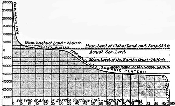
The area of the dry land was taken as 28.3% of the surface of the globe, and that of the oceans as 71.7%. The mean height deduced for the land was 2300 ft. above sea-level, the mean depth of the sea 11,500 ft. below, while the position of mean-sphere Areas of the crust according to Wagner. level comes out as 7500 ft. (1250 fathoms) below sea-level. From this it would appear that 43% of the earth’s surface was above and 57% below the mean level. It must be noted, however, that since 1895 the soundings of Nansen in the north polar area, of the “Valdivia,” “Belgica,” “Gauss” and “Scotia” in the Southern Ocean, and of various surveying ships in the North and South Pacific, have proved that the mean depth of the ocean is considerably greater than had been supposed, and mean-sphere level must therefore lie deeper than the calculations of 1895 show; possibly not far from the position deduced from the freer estimate of 1888. The whole of the available data were utilized by the prince of Monaco in 1905 in the preparation of a complete bathymetrical map of the oceans on a uniform scale, which must long remain the standard work for reference on ocean depths.
By the device of a hypsographic curve co-ordinating the vertical relief and the areas of the earth’s surface occupied by each zone of elevation, according to the system introduced by Supan,19 Wagner showed his results graphically.
This curve with the values reduced from metres to feet is reproduced below.
Wagner subdivides the earth’s surface, according to elevation, into the following five regions:
Wagner’s Divisions of the Earth’s Crust:
Name. Per cent of Surface. From To
Depressed area 3 Deepest. −16,400 feet.
Oceanic plateau 54 −16,400 feet. − 7,400 feet.
Continental slope 9 − 7,400 feet. − 660 feet.
Continental plateau 28 − 660 feet. + 3,000 feet.
Culminating area 6 + 3,300 feet. Highest.
The continental plateau might for purposes of detailed study be divided into the continental shelf from -660 ft. to sea-level, and lowlands from sea-level to +660 ft. (corresponding to the mean level of the whole globe).20 Uplands reaching from 660 ft. to 2300 (the approximate mean level of the land), and highlands, from 2300 upwards, might also be distinguished.
A striking fact in the configuration of the crust is that each continent, or elevated mass of the crust, is diametrically opposite to an ocean basin or great depression; the only partial exception being in the case of southern Arrangement of world-ridges and hollows. South America, which is antipodal to eastern Asia. Professor C. Lapworth has generalized the grand features of crustal relief in a scheme of attractive simplicity. He sees throughout all the chaos of irregular crust-forms the recurrence of a certain harmony, a succession of folds or waves which build up all the minor features.21 One great series of crust waves from east to west is crossed by a second great series of crust waves from north to south, giving rise by their interference to six great elevated masses (the continents), arranged in three groups, each consisting of a northern and a southern member separated by a minor depression. These elevated masses are divided from one another by similar great depressions.
He says: “The surface of each of our great continental masses of land resembles that of a long and broad arch-like form, of which we see the simplest type in the New World. The surface of the North American arch is sagged downwards Lapworth’s fold-theory. in the middle into a central depression which lies between two long marginal plateaus, and these plateaus are finally crowned by the wrinkled crests which form its two modern mountain systems. The surface of each of our ocean floors exactly resembles that of a continent turned upside down. Taking the Atlantic as our simplest type, we may say that the surface of an ocean basin resembles that of a mighty trough or syncline, buckled up more or less centrally in a medial ridge, which is bounded by two long and deep marginal hollows, in the cores of which still deeper grooves sink to the profoundest depths. This complementary relationship descends even to the minor features of the two. Where the great continental sag sinks below the ocean level, we have our gulfs and our Mediterraneans, seen in our type continent, as the Mexican Gulf and Hudson Bay. Where the central oceanic buckle attains the water-line we have our oceanic islands, seen in our type ocean, as St Helena and the Azores. Although the apparent crust-waves are neither equal in size nor symmetrical in form, this complementary relationship between them is always discernible. The broad Pacific depression seems to answer to the broad elevation of the Old World—the narrow trough of the Atlantic to the narrow continent of America.”
The most thorough discussion of the great features of terrestrial relief in the light of their origin is that by Professor E. Suess,22 who points out that the plan of the earth is the result of two movements of the crust—one, subsidence over Suess’s theory. wide areas, giving rise to oceanic depressions and leaving the continents protuberant; the other, folding along comparatively narrow belts, giving rise to mountain ranges. This theory of crust blocks dropped by subsidence is opposed to Lapworth’s theory of vast crust-folds, but geology is the science which has to decide between them.
Geomorphology is concerned, however, in the suggestions which have been made as to the cause of the distribution of heap and hollow in the larger features of the crust. Élie de Beaumont, in his speculations on the relation between the direction of mountain ranges and their geological age and character, was feeling towards a comprehensive theory of the forms of crustal relief; but his ideas were too geometrical, and his theory that the earth is a spheroid built up on a rhombic dodecahedron, the pentagonal faces of which determined the direction of mountain ranges, could not be proved.23 The “tetrahedral theory” brought forward by Lowthian Green,24 that the form of the earth is a spheroid based on a regular tetrahedron, is more serviceable, because it accounts for three very interesting facts of the terrestrial plan—(1) the antipodal position of continents and ocean basins; (2) the triangular outline of the continents; and (3) the excess of sea in the southern hemisphere. Recent investigations have recalled attention to the work of Lowthian Green, but the question is still in the controversial stage.25 The study of tidal strain in the earth’s crust by Sir George Darwin has led that physicist to indicate the possibility of the triangular form and southerly direction of the continents being a result of the differential or tidal attraction of the sun and moon. More recently Professor A.E.H. Love has shown that the great features of the relief of the lithosphere may be expressed by spherical harmonics of the first, second and third degrees, and their formation related to gravitational action in a sphere of unequal density.26
In any case it is fully recognized that the plan of the earth is so clear as to leave no doubt as to its being due to some general cause which should be capable of detection.
If the level of the sea were to become coincident with the mean level of the lithosphere, there would result one tri-radiate land-mass of nearly uniform outline and one continuous sheet of water broken by few islands. The actual position of sea-level lies so near The continents. the summit of the crust-heap that the varied relief of the upper portion leads to the formation of a complicated coast-line and a great number of detached portions of land. The hydrosphere is, in fact, continuous, and the land is all in insular masses: the largest is the Old World of Europe, Asia and Africa; the next in size, America; the third, possibly, Antarctica; the fourth, Australia; the fifth, Greenland. After this there is a considerable gap before New Guinea, Borneo, Madagascar, Sumatra and the vast multitude of smaller islands descending in size by regular gradations to mere rocks. The contrast between island and mainland was natural enough in the days before the discovery of Australia, and the mainland of the Old World was traditionally divided into three continents. These “continents,” “parts of the earth,” or “quarters of the globe,” proved to be convenient divisions; America was added as a fourth, and subsequently divided into two, while Australia on its discovery was classed sometimes as a new continent, sometimes merely as an island, sometimes compromisingly as an island-continent, according to individual opinion. The discovery of the insularity of Greenland might again give rise to the argument as to the distinction between island and continent. Although the name of continent was not applied to large portions of land for any physical reasons, it so happens that there is a certain physical similarity or homology between them which is not shared by the smaller islands or peninsulas.
The typical continental form is triangular as regards its sea-level outline. The relief of the surface typically includes a central plain, sometimes dipping below sea-level, bounded by lateral highlands or mountain ranges, loftier on one side than Homology of continents. on the other, the higher enclosing a plateau shut in by mountains. South America and North America follow this type most closely; Eurasia (the land mass of Europe and Asia) comes next, while Africa and Australia are farther removed from the type, and the structure of Antarctica and Greenland is unknown.
If the continuous, unbroken, horizontal extent of land in a continent is termed its trunk,27 and the portions cut up by inlets or channels of the sea into islands and peninsulas the limbs, it is possible to compare the continents in an instructive manner.
The following table is from the statistics of Professor H. Wagner,28 his metric measurements being transposed into British units:
Comparison of the Continents.
Area total mil. sq. m. Mean height, feet. Area trunk, mil. sq. m. Area penin- sulas, mil. sq. m. Area islands, mil. sq. m. Area limbs, mil. sq. m. Area limbs, per cent.
Old World 35.8 2360
New World 16.2 2230
Eurasia 20.85 2620 15.42 4.09 1.34 5.43 26
Africa 11.46 2130 11.22 .. 0.24 0.24 2.1
North America 9.26 2300 6.92 0.78 1.56 2.34 25
South America 6.84 1970 6.76 0.02 0.06 0.08 1.1
Australia 3.43 1310 2.77 0.16 0.50 0.66 19
Asia 17.02 3120 12.93 3.05 1.04 4.09 24
Europe 3.83 980 2.49 1.04 0.30 1.34 35
The usual classification of islands is into continental and oceanic. The former class includes all those which rise from the continental shelf, or show evidence in the character of their rocks of having at one time been continuous with a neighbouring Islands. continent. The latter rise abruptly from the oceanic abysses. Oceanic islands are divided according to their geological character into volcanic islands and those of organic origin, including coral islands. More elaborate subdivisions according to structure, origin and position have been proposed.29 In some cases a piece of land is only an island at high water, and by imperceptible gradation the form passes into a peninsula. The typical peninsula is connected with the mainland by a relatively narrow isthmus; the name is, however, extended to any limb projecting from the trunk of the mainland, even when, as in the Indian peninsula, it is connected by its widest part.
Small peninsulas are known as promontories or headlands, and the extremity as a cape. The opposite form, an inlet of the sea, is known when wide as a gulf, bay or bight, according to size and degree of inflection, or as a fjord or ria when Coasts. long and narrow. It is convenient to employ a specific name for a projection of a coast-line less pronounced than a peninsula, and for an inlet less pronounced than a bay or bight; outcurve and incurve may serve the turn. The varieties of coast-lines were reduced to an exact classification by Richthofen, who grouped them according to the height and slope of the land into cliff-coasts (Steilküsten)—narrow beach coasts with cliffs, wide beach coasts with cliffs, and low coasts, subdividing each group according as the coast-line runs parallel to or crosses the line of strike of the mountains, or is not related to mountain structure. A further subdivision depends on the character of the inter-relation of land and sea along the shore producing such types as a fjord-coast, ria-coast or lagoon-coast. This extremely elaborate subdivision may be reduced, as Wagner points out, to three types—the continental coast where the sea comes up to the solid rock-material of the land; the marine coast, which is formed entirely of soft material sorted out by the sea; and the composite coast, in which both forms are combined.
On large-scale maps it is necessary to show two coast-lines, one for the highest, the other for the lowest tide; but in small-scale maps a single line is usually wider than is required to represent the whole breadth of the inter-tidal zone. Coast-lines. The measurement of a coast-line is difficult, because the length will necessarily be greater when measured on a large-scale map where minute irregularities can be taken into account. It is usual to distinguish between the general coast-line measured from point to point of the headlands disregarding the smaller bays, and the detailed coast-line which takes account of every inflection shown by the map employed, and follows up river entrances to the point where tidal action ceases. The ratio between these two coast-lines represents the “coastal development” of any region.
While the forms of the sea-bed are not yet sufficiently well known to admit of exact classification, they are recognized to be as a rule distinct from the forms of the land, and the importance of using a distinctive terminology is felt. Efforts have Submarine forms. been made to arrive at a definite international agreement on this subject, and certain terms suggested by a committee were adopted by the Eighth International Geographical Congress at New York in 1904.30 The forms of the ocean floor include the “shelf,” or shallow sea margin, the “depression,” a general term applied to all submarine hollows, and the “elevation.” A depression when of great extent is termed a “basin,” when it is of a more or less round form with approximately equal diameters, a “trough” when it is wide and elongated with gently sloping borders, and a “trench” when narrow and elongated with steeply sloping borders, one of which rises higher than the other. The extension of a trough or basin penetrating the land or an elevation is termed an “embayment” when wide, and a “gully” when long and narrow; and the deepest part of a depression is termed a “deep.” A depression of small extent when steep-sided is termed a “caldron,” and a long narrow depression crossing a part of the continental border is termed a “furrow.” An elevation of great extent which rises at a very gentle angle from a surrounding depression is termed a “rise,” one which is relatively narrow and steep-sided a “ridge,” and one which is approximately equal in length and breadth but steep-sided a “plateau,” whether it springs direct from a depression or from a rise. An elevation of small extent is distinguished as a “dome” when it is more than 100 fathoms from the surface, a “bank” when it is nearer the surface than 100 fathoms but deeper than 6 fathoms, and a “shoal” when it comes within 6 fathoms of the surface and so becomes a serious danger to shipping. The highest point of an elevation is termed a “height,” if it does not form an island or one of the minor forms.
The forms of the dry land are of infinite variety, and have been studied in great detail.31 From the descriptive or topographical point of view, geometrical form alone should be considered; Land forms. but the origin and geological structure of land forms must in many cases be taken into account when dealing with the function they exercise in the control of mobile distributions. The geographers who have hitherto given most attention to the forms of the land have been trained as geologists, and consequently there is a general tendency to make origin or structure the basis of classification rather than form alone.
The fundamental form-elements may be reduced to the six proposed by Professor Penck as the basis of his double system of classification by form and origin.32 These may be looked The six elementary land forms. upon as being all derived by various modifications or arrangements of the single form-unit, the slope or inclined plane surface. No one form occurs alone, but always grouped together with others in various ways to make up districts, regions and lands of distinctive characters. The form-elements are:
1. The plain or gently inclined uniform surface.
2. The scarp or steeply inclined slope; this is necessarily of small extent except in the direction of its length.
3. The valley, composed of two lateral parallel slopes inclined towards a narrow strip of plain at a lower level which itself slopes downwards in the direction of its length. Many varieties of this fundamental form may be distinguished.
4. The mount, composed of a surface falling away on every side from a particular place. This place may either be a point, as in a volcanic cone, or a line, as in a mountain range or ridge of hills.
5. The hollow or form produced by a land surface sloping inwards from all sides to a particular lowest place, the converse of a mount.
6. The cavern or space entirely surrounded by a land surface.
These forms never occur scattered haphazard over a region, but always in an orderly subordination depending on their mode of origin. The dominant forms result from crustal movements, the subsidiary from secondary reactions Geology and land forms. during the action of the primitive forms on mobile distributions. The geological structure and the mineral composition of the rocks are often the chief causes determining the character of the land forms of a region. Thus the scenery of a limestone country depends on the solubility and permeability of the rocks, leading to the typical Karst-formations of caverns, swallow-holes and underground stream courses, with the contingent phenomena of dry valleys and natural bridges. A sandy beach or desert owes its character to the mobility of its constituent sand-grains, which are readily drifted and piled up in the form of dunes. A region where volcanic activity has led to the embedding of dykes or bosses of hard rock amongst softer strata produces a plain broken by abrupt and isolated eminences.33
It would be impracticable to go fully into the varieties of each specific form; but, partly as an example of modern geographical classification, partly because of the exceptional importance of mountains amongst the features of the land, one Classification of mountains. exception may be made. The classification of mountains into types has usually had regard rather to geological structure than to external form, so that some geologists would even apply the name of a mountain range to a region not distinguished by relief from the rest of the country if it bear geological evidence of having once been a true range. A mountain may be described (it cannot be defined) as an elevated region of irregular surface rising comparatively abruptly from lower ground. The actual elevation of a summit above sea-level does not necessarily affect its mountainous character; a gentle eminence, for instance, rising a few hundred feet above a tableland, even if at an elevation of say 15,000 ft., could only be called a hill.34 But it may be said that any abrupt slope of 2000 ft. or more in vertical height may justly be called a mountain, while abrupt slopes of lesser height may be called hills. Existing classifications, however, do not take account of any difference in kind between mountain and hills, although it is common in the German language to speak of Hügelland, Mittelgebirge and Hochgebirge with a definite significance.
The simple classification employed by Professor James Geikie35 into mountains of accumulation, mountains of elevation and mountains of circumdenudation, is not considered sufficiently thorough by German geographers, who, following Richthofen, generally adopt a classification dependent on six primary divisions, each of which is subdivided. The terms employed, especially for the subdivisions, cannot be easily translated into other languages, and the English equivalents in the following table are only put forward tentatively:—
Richthofen’s Classification of Mountains36
I. Tektonische Gebirge—Tectonic mountains. (a) Bruchgebirge oder Schollengebirge—Block mountains. 1. Einseitige Schollengebirge oder Schollenrandgebirge—Scarp or tilted block mountains. (i.) Tafelscholle—Table blocks. (ii.) Abrasionsscholle—Abraded blocks. (iii.) Transgressionsscholle—Blocks of unconformable strata. 2. Flexurgebirge—Flexure mountains. 3. Horstgebirge—Symmetrical block mountains. (b) Faltungsgebirge—Fold mountains. 1. Homöomorphe Faltungsgebirge—Homomorphic fold mountains. 2. Heteromorphe Faltungsgebirge—Heteromorphic fold mountains. II. Rumpfgebirge oder Abrasionsgebirge—Trunk or abraded mountains. III. Ausbruchsgebirge—Eruptive mountains. IV. Aufschüttungsgebirge—Mountains of accumulation. V. Flachböden—Plateaux. (a) Abrasionsplatten—Abraded plateaux. (b) Marines Flachland—Plain of marine erosion. (c) Schichtungstafelland—Horizontally stratified tableland. (d) Übergusstafelland—Lava plain. (e) Stromflachland—River plain. (f) Flachböden der atmosphärischen Aufschüttung—Plains of aeolian formation. VI. Erosionsgebirge—Mountains of erosion.
From the morphological point of view it is more important to distinguish the associations of forms, such as the mountain mass or group of mountains radiating from a centre, with the valleys furrowing their flanks spreading towards every Mountain forms. direction; the mountain chain or line of heights, forming a long narrow ridge or series of ridges separated by parallel valleys; the dissected plateau or highland, divided into mountains of circumdenudation by a system of deeply-cut valleys; and the isolated peak, usually a volcanic cone or a hard rock mass left projecting after the softer strata which embedded it have been worn away (Monadnock of Professor Davis).
The geographical distribution of mountains is intimately associated with the great structural lines of the continents of which they form the culminating region. Lofty lines of fold mountains form the “backbones” of North America in the Rocky Distribution of mountains. Mountains and the west coast systems, of South America in the Cordillera of the Andes, of Europe in the Pyrenees, Alps, Carpathians and Caucasus, and of Asia in the mountains of Asia Minor, converging on the Pamirs and diverging thence in the Himalaya and the vast mountain systems of central and eastern Asia. The remarkable line of volcanoes around the whole coast of the Pacific and along the margin of the Caribbean and Mediterranean seas is one of the most conspicuous features of the globe.
If land forms may be compared to organs, the part they serve in the economy of the earth may, without straining the term, be characterized as functions. The first and simplest Functions of land forms. Land waste. function of the land surface is that of guiding loose material to a lower level. The downward pull of gravity suffices to bring about the fall of such material, but the path it will follow and the distance it will travel before coming to rest depend upon the land form. The loose material may, and in an arid region does, consist only of portions of the higher parts of the surface detached by the expansion and contraction produced by heating and cooling due to radiation. Such broken material rolling down a uniform scarp would tend to reduce its steepness by the loss of material in the upper part and by the accumulation of a mound or scree against the lower part of the slope. But where the side is not a uniform scarp, but made up of a series of ridges and valleys, the tendency will be to distribute the detritus in an irregular manner, directing it away from one place and collecting it in great masses in another, so that in time the land form assumes a new appearance. Snow accumulating on the higher portions of the land, when compacted into ice and caused to flow downwards by gravity, gives rise, on Glaciers. account of its more coherent character, to continuous glaciers, which mould themselves to the slopes down which they are guided, different ice-streams converging to send forward a greater volume. Gradually coming to occupy definite beds, which are deepened and polished by the friction, they impress a characteristic appearance on the land, which guides them as they traverse it, and, although the ice melts at lower levels, vast quantities of clay and broken stones are brought down and deposited in terminal moraines where the glacier ends.
Rain is by far the most important of the inorganic mobile distributions upon which land forms exercise their function of guidance and control. The precipitation of rain from the aqueous Rain. vapour of the atmosphere is caused in part by vertical movements of the atmosphere involving heat changes and apparently independent of the surface upon which precipitation occurs; but in greater part it is dictated by the form and altitude of the land surface and the direction of the prevailing winds, which itself is largely influenced by the land. It is on the windward faces of the highest ground, or just beyond the summit of less dominant heights upon the leeward side, that most rain falls, and all that does not evaporate or percolate into the ground is conducted back to the sea by a route which depends only on the form of the land. More mobile and more searching than ice or rock rubbish, the trickling drops are guided by the deepest lines of the hillside in their incipient flow, and as these River systems. lines converge, the stream, gaining strength, proceeds in its torrential course to carve its channel deeper and entrench itself in permanent occupation. Thus the stream-bed, from which at first the water might be blown away into a new channel by a gale of wind, ultimately grows to be the strongest line of the landscape. As the main valley deepens, the tributary stream-beds are deepened also, and gradually cut their way headwards, enlarging the area whence they draw their supplies. Thus new land forms are created—valleys of curious complexity, for example—by the “capture” and diversion of the water of one river by another, leading to a change of watershed.37 The minor tributaries become more numerous and more constant, until the system of torrents has impressed its own individuality on the mountain side. As the river leaves the mountain, ever growing by the accession of tributaries, it ceases, save in flood time, to be a formidable instrument of destruction; the gentler slope of the land surface gives to it only power sufficient to transport small stones, gravel, sand and ultimately mud. Its valley banks are cut back by the erosion of minor tributaries, or by rain-wash if the climate be moist, or left steep and sharp while the river deepens its bed if the climate be arid. The outline of the curve of a valley’s sides ultimately depends on the angle of repose of the detritus which covers them, if there has been no subsequent change, such as the passage of a glacier along the valley, which tends to destroy the regularity of the cross-section. The slope of the river bed diminishes until the plain compels the river to move slowly, swinging in meanders proportioned to its size, and gradually, controlled by the flattening land, ceasing to transport material, but raising its banks and silting up its bed by the dropped sediment, until, split up and shoaled, its distributaries struggle across its delta to the sea. This is the typical river of which there are infinite varieties, yet every variety would, if time were given, and the land remained unchanged in level relatively to the sea, ultimately approach to the type. Movements of the land Adjustment of rivers to land. either of subsidence or elevation, changes in the land by the action of erosion in cutting back an escarpment or cutting through a col, changes in climate by affecting the rainfall and the volume of water, all tend to throw the river valley out of harmony with the actual condition of its stream. There is nothing more striking in geography than the perfection of the adjustment of a great river system to its valleys when the land has remained stable for a very lengthened period. Before full adjustment has been attained the river bed may be broken in places by waterfalls or interrupted by lakes; after adjustment the bed assumes a permanent outline, the slope diminishing more and more gradually, without a break in its symmetrical descent. Excellent examples of the indecisive drainage of a new land surface, on which the river system has not had time to impress itself, are to be seen in northern Canada and in Finland, where rivers are separated by scarcely perceptible divides, and the numerous lakes frequently belong to more than one river system.
The action of rivers on the land is so important that it has been made the basis of a system of physical geography by Professor W.M. Davis, who classifies land surfaces in terms of the three factors—structure, process and time.38 Of The geographical cycle. these time, during which the process is acting on the structure, is the most important. A land may thus be characterized by its position in the “geographical cycle”, or cycle of erosion, as young, mature or old, the last term being reached when the base-level of erosion is attained, and the land, however varied its relief may have been in youth or maturity, is reduced to a nearly uniform surface or peneplain. By a re-elevation of a peneplain the rivers of an old land surface may be restored to youthful activity, and resume their shaping action, deepening the old valleys and initiating new ones, starting afresh the whole course of the geographical cycle. It is, however, not the action of the running water on the land, but the function exercised by the land on the running water, that is considered here to be the special province of geography. At every stage of the geographical cycle the land forms, as they exist at that stage, are concerned in guiding the condensation and flow of water in certain definite ways. Thus, for example, in a mountain range at right angles to a prevailing sea-wind, it is the land forms which determine that one side of the range shall be richly watered and deeply dissected by a complete system of valleys, while the other side is dry, indefinite in its valley systems, and sends none of its scanty drainage to the sea. The action of rain, ice and rivers conspires with the movement of land waste to strip the layer of soil from steep slopes as rapidly as it forms, and to cause it to accumulate on the flat valley bottoms, on the graceful flattened cones of alluvial fans at the outlet of the gorges of tributaries, or in the smoothly-spread surface of alluvial plains.
The whole question of the régime of rivers and lakes is sometimes treated under the name hydrography, a name used by some writers in the sense of marine surveying, and by others as synonymous with oceanography. For the study of rivers alone the name potamology39 has been suggested by Penck, and the subject being of much practical importance has received a good deal of attention.40
The study of lakes has also been specialized under the name of limnology (see Lake).41 The existence of lakes in hollows of the land depends upon the balance between precipitation and evaporation. A stream flowing into a hollow will tend to fill it up, and Lakes and internal drainage. the water will begin to escape as soon as its level rises high enough to reach the lowest part of the rim. In the case of a large hollow in a very dry climate the rate of evaporation may be sufficient to prevent the water from ever rising to the lip, so that there is no outflow to the sea, and a basin of internal drainage is the result. This is the case, for instance, in the Caspian sea, the Aral and Balkhash lakes, the Tarim basin, the Sahara, inner Australia, the great basin of the United States and the Titicaca basin. These basins of internal drainage are calculated to amount to 22% of the land surface. The percentages of the land surface draining to the different oceans are approximately—Atlantic, 34.3%; Arctic sea, 16.5%; Pacific, 14.4%; Indian Ocean, 12.8%.42
The parts of a river system have not been so clearly defined as is desirable, hence the exaggerated importance popularly attached to “the source” of a river. A well-developed river system has in fact many equally important and widely-separated Terminology of river systems. sources, the most distant from the mouth, the highest, or even that of largest initial volume not being necessarily of greater geographical interest than the rest. The whole of the land which directs drainage towards one river is known as its basin, catchment area or drainage area—sometimes, by an incorrect expression, as its valley or even its watershed. The boundary line between one drainage area and others is rightly termed the watershed, but on account of the ambiguity which has been tolerated it is better to call it water-parting or, as in America, divide. The only other important term which requires to be noted here is talweg, a word introduced from the German into French and English, and meaning the deepest line along the valley, which is necessarily occupied by a stream unless the valley is dry.
The functions of land forms extend beyond the control of the circulation of the atmosphere, the hydrosphere and the water which is continually being interchanged between them; they are exercised with increased effect in the higher departments of biogeography and anthropogeography.
The sum of the organic life on the globe is termed by some geographers the biosphere, and it has been estimated that the whole mass of living substance in existence at one time would cover the surface of the earth to a depth of one-fifth of Biogeography. an inch.43 The distribution of living organisms is a complex problem, a function of many factors, several of which are yet but little known. They include the biological nature of the organism and its physical environment, the latter involving conditions in which geographical elements, direct or indirect, preponderate. The direct geographical elements are the arrangement of land and sea (continents and islands standing in sharp contrast) and the vertical relief of the globe, which interposes barriers of a less absolute kind between portions of the same land area or oceanic depression. The indirect geographical elements, which, as a rule, act with and intensify the direct, are mainly climatic; the prevailing winds, rainfall, mean and extreme temperatures of every locality depending on the arrangement of land and sea and of land forms. Climate thus guided affects the weathering of rocks, and so determines the kind and arrangement of soil. Different species of organisms come to perfection in different climates; and it may be stated as a general rule that a species, whether of plant or animal, once established at one point, would spread over the whole zone of the climate congenial to it unless some barrier were interposed to its progress. In the case of land and fresh-water organisms the sea is the chief barrier; in the case of marine organisms, the land. Differences in land forms do not exert great influence on the distribution of living creatures directly, but indirectly such land forms as mountain ranges and internal drainage basins are very potent through their action on soil and climate. A snow-capped mountain ridge or an arid desert forms a barrier between different forms of life which is often more effective than an equal breadth of sea. In this way the surface of the land is divided into numerous natural regions, the flora and fauna of each of which include some distinctive species not shared by the others. The distribution of life is discussed in the various articles in this Encyclopaedia dealing with biological, botanical and zoological subjects.44
The classification of the land surface into areas inhabited by distinctive groups of plants has been attempted by many phyto-geographers, but without resulting in any scheme of general acceptance. The simplest classification is perhaps Floral zones. that of Drude according to climatic zones, subdivided according to continents. This takes account of—(1) the Arctic-Alpine zone, including all the vegetation of the region bordering on perpetual snow; (2) the Boreal zone, including the temperate lands of North America, Europe and Asia, all of which are substantially alike in botanical character; (3) the Tropical zone, divided sharply into (a) the tropical zone of the New World, and (b) the tropical zone of the Old World, the forms of which differ in a significant degree; (4) the Austral zone, comprising all continental land south of the equator, and sharply divided into three regions the floras of which are strikingly distinct—(a) South American, (b) South African and (c) Australian; (5) the Oceanic, comprising all oceanic islands, the flora of which consists exclusively of forms whose seeds could be drifted undestroyed by ocean currents or carried by birds. To these might be added the antarctic, which is still very imperfectly known. Many subdivisions and transitional zones have been suggested by different authors.
From the point of view of the economy of the globe this classification by species is perhaps less important than that by mode of life and physiological character in accordance with environment. The following are the chief areas of Vegetation areas. vegetational activity usually recognized: (1) The ice-deserts of the arctic and antarctic and the highest mountain regions, where there is no vegetation except the lowest forms, like that which causes “red snow.” (2) The tundra or region of intensely cold winters, forbidding tree-growth, where mosses and lichens cover most of the ground when unfrozen, and shrubs occur of species which in other conditions are trees, here stunted to the height of a few inches. A similar zone surrounds the permanent snow on lofty mountains in all latitudes. The tundra passes by imperceptible gradations into the moor, bog and heath of warmer climates. (3) The temperate forests of evergreen or deciduous trees, according to circumstances, which occupy those parts of both temperate zones where rainfall and sunlight are both abundant. (4) The grassy steppes or prairies where the rainfall is diminished and temperatures are extreme, and grass is the prevailing form of vegetation. These pass imperceptibly into—(5) the arid desert, where rainfall is at a minimum, and the only plants are those modified to subsist with the smallest supply of water. (6) The tropical forest, which represents the maximum of plant luxuriance, stimulated by the heaviest rainfall, greatest heat and strongest light. These divisions merge one into the other, and admit of almost indefinite subdivision, while they are subject to great modifications by human interference in clearing and cultivating. Plants exhibit the controlling power of environment to a high degree, and thus vegetation is usually in close adjustment to the bolder geographical features of a region.
The divisions of the earth into faunal regions by Dr P.L. Sclater have been found to hold good for a large number of groups of animals as different in their mode of life as birds and mammals, and they may thus be accepted as based on nature. Faunal realms. They are six in number: (1) Palaearctic, including Europe, Asia north of the Himalaya, and Africa north of the Sahara; (2) Ethiopian, consisting of Africa south of the Atlas range, and Madagascar; (3) Oriental, including India, Indo-China and the Malay Archipelago north of Wallace’s line, which runs between Bali and Lombok; (4) Australian, including Australia, New Zealand, New Guinea and Polynesia; (5) Nearctic or North America, north of Mexico; and (6) Neotropical or South America. Each of these divisions is the home of a special fauna, many species of which are confined to it alone; in the Australian region, indeed, practically the whole fauna is peculiar and distinctive, suggesting a prolonged period of complete biological isolation. In some cases, such as the Ethiopian and Neotropical and the Palaearctic and Nearctic regions, the faunas, although distinct, are related, several forms on opposite sides of the Atlantic being analogous, e.g. the lion and puma, ostrich and rhea. Where two of the faunal realms meet there is usually, though not always, a mixing of faunas. These facts have led some naturalists to include the Palaearctic and Nearctic regions in one, termed Holarctic, and to suggest transitional regions, such as the Sonoran, between North and South America, and the Mediterranean, between Europe and Africa, or to create sub-regions, such as Madagascar and New Zealand. Oceanic islands have, as a rule, distinctive faunas and floras which resemble, but are not identical with, those of other islands in similar positions.
The study of the evolution of faunas and the comparison of the faunas of distant regions have furnished a trustworthy instrument of pre-historic geographical research, which Biological distribution as a means of geographical research. enables earlier geographical relations of land and sea to be traced out, and the approximate period, or at least the chronological order of the larger changes, to be estimated. In this way, for example, it has been suggested that a land, “Lemuria,” once connected Madagascar with the Malay Archipelago, and that a northern extension of the antarctic land once united the three southern continents.
The distribution of fossils frequently makes it possible to map out approximately the general features of land and sea in long-past geological periods, and so to enable the history of crustal relief to be traced.45
While the tendency is for the living forms to come into harmony with their environment and to approach the state of equilibrium by successive adjustments if the environment should happen to change, it is to be observed that the action Reaction of organisms on environment. of organisms themselves often tends to change their environment. Corals and other quick-growing calcareous marine organisms are the most powerful in this respect by creating new land in the ocean. Vegetation of all sorts acts in a similar way, either in forming soil and assisting in breaking up rocks, in filling up shallow lakes, and even, like the mangrove, in reclaiming wide stretches of land from the sea. Plant life, utilizing solar light to combine the inorganic elements of water, soil and air into living substance, is the basis of all animal life. This is not by the supply of food alone, but also by the withdrawal of carbonic acid from the atmosphere, by which vegetation maintains the composition of the air in a state fit for the support of animal life. Man in the primitive stages of culture is scarcely to be distinguished from other animals as regards his subjection to environment, but in the higher grades of culture the conditions of control and reaction become much more complicated, and the department of anthropogeography is devoted to their consideration.
The first requisites of all human beings are food and protection, in their search for which men are brought into intimate relations with the forms and productions of the earth’s surface. The degree of dependence of any people upon environment Anthropogeography. varies inversely as the degree of culture or civilization, which for this purpose may perhaps be defined as the power of an individual to exercise control over the individual and over the environment for the benefit of the community. The development of culture is to a certain extent a question of race, and although forming one species, the varieties of man differ in almost imperceptible gradations with a complexity defying classification (see Anthropology). Professor Keane groups man round four leading types, which may be named the black, yellow, red and white, or the Ethiopic, Mongolic, American and Caucasic. Each may be subdivided, though not with great exactness, into smaller groups, either according to physical characteristics, of which the form of the head is most important, or according to language.
The black type is found only in tropical or sub-tropical countries, and is usually in a primitive condition of culture, unless educated by contact with people of the white type. They follow the most primitive forms of religion (mainly fetishism), Types of man. live on products of the woods or of the chase, with the minimum of work, and have only a loose political organization. The red type is peculiar to America, inhabiting every climate from polar to equatorial, and containing representatives of many stages of culture which had apparently developed without the aid or interference of people of any other race until the close of the 15th century. The yellow type is capable of a higher culture, cherishes higher religious beliefs, and inhabits as a rule the temperate zone, although extending to the tropics on one side and to the arctic regions on the other. The white type, originating in the north temperate zone, has spread over the whole world. They have attained the highest culture, profess the purest forms of monotheistic religion, and have brought all the people of the black type and many of those of the yellow under their domination.
The contrast between the yellow and white types has been softened by the remarkable development of the Japanese following the assimilation of western methods.
The actual number of human inhabitants in the world has been calculated as follows:
By Continents.46 By Race.47
Asia 875,000,000 White (Caucasic) 770,000,000
Europe 392,000,000 Yellow (Mong.) 540,000,000
Africa 170,000,000 Black (Ethiopic) 175,000,000
America 143,000,000 Red (American) 22,000,000
Australia and Polynesia 7,000,000 —————
————— Total 1,507,000,000
Total 1,587,000,000
In round numbers the population of the world is about 1,600,000,000, and, according to an estimate by Ravenstein,48 the maximum population which it will be possible for the earth to maintain is 6000 millions, a number which, if the average rate of increase in 1891 continued, would be reached within 200 years.
While highly civilized communities are able to evade many of the restrictions of environment, to overcome the barriers to intercommunication interposed by land or sea, to counteract the adverse influence of climate, and by the development of trade even to inhabit countries which cannot yield a food-supply, the mass of mankind is still completely under the control of those conditions which in the past determined the distribution and the mode of life of the whole human race.