VOLUME V SLICE VI Celtes, Konrad to Ceramics (continued 3)
Reading edition
The Mesozoic series begins with sands and red or yellow clays containing plant remains and possibly of Triassic age; but the occurrence of these deposits is limited to a few small isolated outcrops. Jurassic beds have been found in Mexico but not in Central America. The Cretaceous system, consisting of a lower series of clays, sandstones and conglomerates, followed conformably by an upper series of limestones, covers a considerable area in Chiapas, Guatemala and Honduras, and is found also in Costa Rica. The upper series contains hippurites. The greater part of the eastern half of the Mexican plateau is also formed of Cretaceous beds.
The Tertiary system may be conveniently divided into two divisions. The lower, of Eocene and Oligocene age, consists generally of sand and clays which were evidently laid down near a shore line. The upper division also, including the Pliocene and Pleistocene (which have not yet been clearly distinguished from each other), is usually of shallow water origin; but in the northern part of Yucatan it includes beds of chalky limestone, like those of the Antilles, which may have been deposited in a deeper sea.
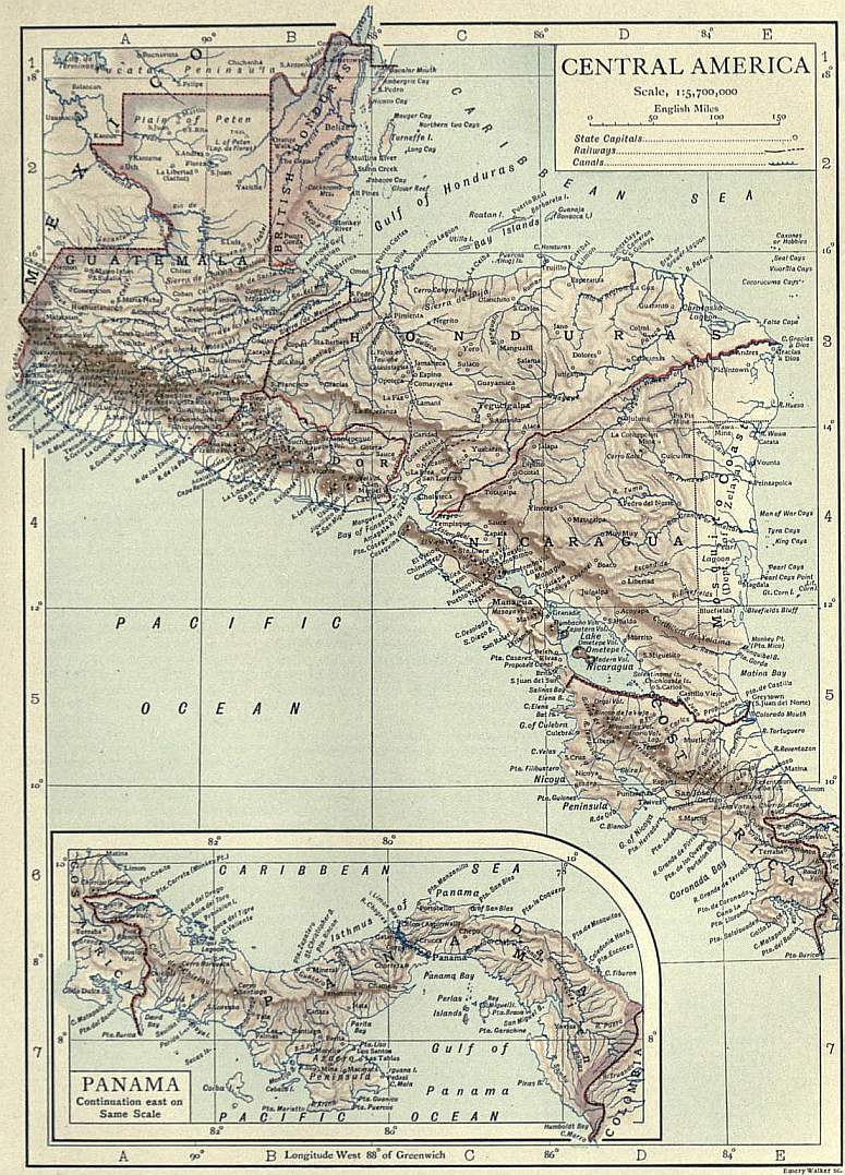
It is probable that folding took place at more than one geological epoch, and the whole series of beds up to the Oligocene is involved in the folds. The Pliocene, on the other hand, is usually undisturbed, and the final effort must, therefore, have occurred during the Miocene period, which appears to have been a period of great earth movement throughout the Caribbean region. From the southern extremity of the Mexican plateau to the Colombian border, the strike of the folds—of the Mesozoic and early Tertiary deposits, as well as of the older rocks—is in general from east to west; but there is one considerable exception. On both sides of the deep depression which crosses Honduras from Puerto Cortez to the Gulf of Fonseca, the strike is commonly from north to south. The depression is probably a “Graben” or trough formed by faulting.
The great volcanoes of Mexico and Central America stand upon the Pacific side of the continent, and it is only where the land contracts to a narrow neck that their products spread over to the Caribbean shore. The extent of the volcanic deposits is very great, and over a wide area they entirely conceal the original structural features of the country. The eruptions began towards the close of the Cretaceous period and continue to the present day. The rocks are lavas and ashes, chiefly of andesitic or basaltic composition, but rhyolites and trachytes also occur, and phonolite has been met with in one or two places.
According to R.T. Hill, there is but little geological evidence of any Tertiary or later connexion between the Caribbean Sea and the Pacific, excepting, perhaps, a shallow opening during the Eocene period. It should, however, be stated that all authorities are not agreed upon this point, and K. Sapper found marls and sandstones which he believes to belong to the Upper Tertiary, lying horizontally at a height of about 7500 ft. in the Mexican state of Chiapas. Unfortunately the fossils obtained from these beds were lost.
Climate.—The climate of Central America is subject to the most marked local differences of heat and cold, owing partly to the proximity of two oceans, partly to the variations of altitude which render such territories as the swamps of the coast, or the lowlands of British Honduras and northern Guatemala, totally unlike the alpine regions of Salvador and Costa Rica. The whole area may, however, be roughly divided into a tropical zone (tierra caliente), from sea-level to about 1500 ft.; a temperate zone (tierra templada), from 1500 to 5000 ft.; and a cold zone (tierra fria), above 5000 ft. These figures are, of course, only approximately correct; and it often happens that, at the same elevation, the heat is greater on the Pacific than on the Atlantic versant. The rainy season on the Pacific slope varies in duration from four to six months, between April and December. It lengthens as the altitude increases. On the coast, it corresponds with the prevalence of the south-west monsoon, the tempestuous Cordonazo de San Francisco, or “Flagellation of St Francis,” as it is called in Mexico, and it is often interrupted by an interval of two or three weeks of fine weather, known as the Veranillo de San Juan, or “Little summer of St John.” In the rainy season, the morning has usually a clear sky; about two or three o’clock in the afternoon the clouds begin to gather in great cumulus masses; suddenly the lightning flashes out and the rain crashes down; and by evening the sky is clear and starry. North winds are most usual during the dry season. On the Atlantic coast the trade-winds may bring rain in any month, and, owing to the moist atmosphere, the heat is more oppressive. The rainfall may vary in successive years from less than 50 in. to nearly 200 in., owing to the occurrence of cloud-bursts. Frosts are not rare above 7000 ft., but snow seldom falls.
Fauna.—The fauna of Central America is more closely connected with the fauna of South than with that of North America. As the region is comparatively small, and its limits conventional, there are comparatively few species that it can claim as peculiarly its own. It is almost entirely free from the presence of animals dangerous to man. Of felines it possesses the jaguar (Felis onza), popularly called the tiger; the cuguar (Felis concolor), popularly called the lion; the tigrillo (Felis tigrina), which is sometimes kept tame; and other species. Several species of monkeys (Mycetes and Ateles) are numerous in the warm coast region. The Mexican deer (Cervus mexicanus) has a wide range both in the lowlands and highlands. Besides the tapir there are several varieties of wild pig, such as the marrano de monte (Sus torquatus) and the jabali or javali (Sus labiatus javali). The Edentata are represented by a species of armadillo, the honey-bear (Myrmecophaga tomandua), and the Myrmecophaga didactyla; and among the rodents may be mentioned, besides rats, hares and rabbits, the fruit-eating cotorra and tepes-cuinte (Dasyprocta aguti and Coelogenys paca), and the troublesome Geomys mexicana. The manatee is common in all the larger streams. Much annoyance is caused to the agriculturist by the little marsupial called the tacuacine, or the Didelphys carcinora, its allied species. The bats are so numerous that villages have sometimes had to be left to their undisputed occupancy. In the south-east of Costa Rica the inhabitants are at times compelled to withdraw, with all their live-stock, before the swarms of large migratory vampires which in a single night can bleed the strongest animal to death. Most of the domestic animals—the horse, ox, goat, sheep, pig, dog, rabbit, common fowl, peacock and pigeon—are of European origin, and are popularly grouped together as animales de Castilla. For the bird collector there is a rich harvest. The catalogue of the National Museum at Washington shows that Costa Rica alone possesses more than twice as many species of birds as the whole of Europe. Among birds of prey it is sufficient to mention Corogyps atratus, the commonest of the vultures, which acts as a universal scavenger, the Cathartes aura, the beautiful Polyborus vulgaris, and the king of the vultures (Sarcorhamphus papa). Neither the condor of the southern continent nor the great eagles of the northern are known. The parrot, macaw and toucan are found in all parts; the crow, blackbird, Mexican jay, ricebird, swallow, rainbird, wood-pecker, humming-bird and trogon are also widely distributed. A bird of the last-named genus, the quetzal, quijal or quesal (Trogon resplendens) is of special note, not only from the fact that its yellow tail-feathers. 2 or 3 ft. long, were formerly worn as insignia by the Indian princes, but because it has been adopted as the emblematical figure on the national arms of Guatemala. The gallinaceous order is well represented, and comprises several peculiar species, as the pavo de cacho, and the Peten turkey (Meleagris ocellata), which has a bronze sheen on its plumage; and aquatic birds, it is almost needless to add, are unusually numerous in a region so richly furnished with lagoons, rivers and lakes.
Besides the alligator, which swarms in many rivers, the almost endless varieties of Central American reptiles include the harmless boba or chicken-snake, python and black snake; the venomous corali, taboba, culebra de sangre and rattlesnake; iguanas of great size, scorpions, edible lizards and other lizards said to be poisonous. In the rivers and lakes, as in both seas, fish of many kinds abound; turtles and tortoises are exported; and there are valuable pearl and oyster fisheries. Insect life is even richer and more varied. Of the Coleoptera, the Camelicorns, the Longicorns, the Curculionids, and the Chrysomelines are said to be best represented, and of the Lepidoptera the prevalent genera are—Ageronia, Papilio, Heliconia, Sphinx and Bombyx. There are five species of bees, and the European honey-bee, known as aveja de Castilla or “bee of Castile,” has been naturalized. Ants are common, and may sometimes be seen marching in a column 3 or 4 m. long. The mosquito, wood-tick, flea and locust are unfortunately no less plentiful in certain districts, but their distribution varies greatly, the mosquito being almost unknown in parts of Honduras. A curious species of butterfly is the Timetes Chiron, which migrates in countless multitudes from the forests of Honduras to the Mosquito Coast, but is never known to return.
Flora.—The flora of Central America ranges from the alpine to the tropical, with the transition from one climatic zone to another. Although its forest growths are, on the whole, inferior in size to those of corresponding latitudes in the eastern hemisphere, it is unsurpassed for beauty, luxuriance and variety. In the volcanic districts, the soil is extremely fertile, yielding, where cultivated and irrigated, magnificent crops of sugar, cotton, rice, tobacco, coffee, cocoa and maize. Indigo is produced in small quantities; sugar yields two or three crops, and maize as many as four, this cereal supplying a chief staple of food. Plantains, bananas, beans, tomatoes, yams, arrowroot, pine-apples, guavas, citrons and many other tropical fruits are also cultivated, while the extensive primeval forests abound in mahogany, cedars, rosewood, ironwood, rubber, gum copal, vanilla, sarsaparilla, logwood and many other dye-woods, medicinal plants, and valuable timbers. Conspicuous amongst the forest trees are the giant ceiba, or pyramidal bombax, and the splendid Coyal palm (Cocos butyracea, L.), with feathery leaves 15 to 20 ft. long, golden flowers 3 ft. high, and a sap which when fermented produces the intoxicating chicha or vino de Coyol. In Guatemala occurs the remarkable Herrania purpurea, a “Chocolate tree,” whose seeds yield a finer flavoured chocolate than the cocoa itself. The same country is famous for its magnificent orchids, huge arborescent thistles, and a remarkable plant called by the Spaniards Flor de la Calentura, “fever flower,” from the heat which it is said to emit at the moment of fertilization. Salvador produces an abundance of medicinal plants, notably the so-called Peruvian balsam (Myrospermum salvatorense); in Honduras there are immense forests of conifers, resembling those of the Landes in France; in Nicaragua a characteristic tree is the cortes (Tecoma sideroxylori) yielding timber as hard as ebony, and noteworthy for the golden blossom with which it is entirely covered after the leaves have fallen.
Inhabitants—In 1905 the population of Central America numbered about 4,750,000, and this total tends to increase, despite the unhealthy climate of many districts, the terribly high average of infant mortality, and the slow progress of immigration. Some authorities estimate it at 5,500,000. The vast majority of the inhabitants are of mixed Indian and Spanish blood, but the Indian element predominates everywhere except in Costa Rica, where the whites are exceptionally numerous. The Indian races have not shown the same power to adapt themselves to modern civilization as the Mexicans; in some regions there are tribes remaining in a state of complete savagery although before the Spanish conquest their ancestors attained a high level of culture (see below under Archaeology). The density of population throughout Central America is little more than 25 per sq. m.; and it is clear that several large areas now thinly peopled once maintained a far greater number of inhabitants. Such are parts of the Nicaraguan lake district, where the flora consists in great measure of plants that were formerly cultivated by the Indians. The depopulation of these areas was effected partly by tribal wars, partly by the harsh rule of the Spaniards. Apart from the German agricultural settlements in Guatemala and elsewhere, the foreign population is chiefly confined to the seaports and other centres of commerce, Great Britain, Germany and the United States being largely represented among the wealthier classes of residents; while the foreign labourers are mostly Italians or negroes, with a few Chinese on the Pacific coast.
History.—Central America was discovered by Columbus in August 1502; and part of the territory which is now Costa Rica was conquered by the Spaniards under Pedro Arias de Avila after 1513. Between 1522 and 1525, the authority of Avila was superseded, and his work of conquest completed by Hernando Cortes, who had already subjugated Mexico. Panama formed part of a distinct Spanish government, “New Granada”; British Honduras was colonized, though not formally annexed, in the 18th century; and over the Mosquito Coast the British government exercised a nominal protectorate after 1665. Otherwise the rest of Central America remained a Spanish dependency bearing the general name of “Guatemala,” until 1821. It ranked as a captaincy-general under the rule of a military governor, and was organized in five departments, corresponding in area with the modern republics of Guatemala, Honduras, Salvador, Nicaragua and Costa Rica. For three centuries it was administered by Spanish officials, who almost invariably devoted their whole energy to enriching themselves and the home authorities. The old Indian civilization was swept away; the native races were enslaved, maltreated and, for a time, demoralized. But their history offers no parallel to that of the West Indian Caribs, who failed to survive, and were replaced by hordes of African slaves. In Central America the Indians not only survived, thus leaving no room for any large negro population, but quickly acquired the language, religion and habits of their masters, with whom they intermarried. By the close of the 18th century, the majority had attained something like uniformity of life and thought. Racial distinctions had been obscured by intermarriage; even the term Ladino, or “Latin,” came to mean an educated man, whether of Spanish or Indian blood. Nowhere, except in Mexico, has a mixed or coloured race more completely absorbed the civilization of its white rulers; but so gradual and silent was the process that it passed almost unnoticed. Its result, the successful revolt of the Spanish colonies—colonies mainly peopled by Indians or half-castes—was no more a conflict of rival races or civilizations than the rebellion of the British colonies in North America.
“New Granada” attained its independence in 1819; and in 1821 “Guatemala” declared itself free. That the subsequent history of the Central American republics has been largely a record of civil war, maladministration and financial dishonesty, is perhaps due in part to racial inferiority. In part, however, it may be explained by the absence of any tradition of good government; perhaps also by the brevity and artificiality of the evolution which converted a debased slave-population into the citizens of modern democratic states. The five divisions of “Guatemala” were temporarily incorporated in the Mexican empire during 1822, but regained their autonomy (as Guatemala, Honduras, Salvador, Nicaragua and Costa Rica) on the declaration of a Mexican republic, and in July 1823 combined to form the Republic of the United States of Central America. The Liberal or Federalist party, which was supreme in Honduras, found itself opposed by the Conservatives, including the clergy and former Spanish officials, who were very influential in Guatemala. A bitter and protracted struggle ensued. In 1837-1839 a Conservative rising, under Rafael Carrera, president of Guatemala, resulted in the overthrow of the Liberals, under General Francisco Morazan of Honduras; and in 1842, after a vain attempt to restore the Federal republic, Morazan was captured and shot. A fresh union of the republics (except Costa Rica) was concluded in 1842, and dissolved in 1845. The year 1850 was signalized by the conclusion, on the 19th of April, of the Clayton-Bulwer treaty (q.v.) between Great Britain and the United States, which was designed to facilitate the construction of an interoceanic canal. The history of this project is given in detail under Panama Canal. One important result of the treaty was the abandonment, in 1860, of the British protectorate over the Mosquito Coast. This event had been preceded by a decade of political disturbances. In 1850 Honduras, Salvador and Nicaragua had combined to restore federal unity; but their allied armies were defeated by the Guatemalans under Carrera. In 1856 the American adventurer, William Walker, endeavoured to usurp the government of Nicaragua; in 1860 he invaded Honduras and was captured and shot. His object was to assist the slave-holders of the United States by adding new slave-states to the Union. A further attempt to restore federal unity failed in 1885, and its promoter, Justo Rufino Barrios, president of Guatemala, lost his life. In 1895 the Greater Republic of Central America was formed by the union of Nicaragua, Salvador and Honduras; and a constitution was framed providing for the admission of Guatemala and Costa Rica; in December 1898 it was dissolved, as unsatisfactory to Salvador. On the 4th of November 1903 Panama, which had since 1863 formed part of Colombia, declared itself an autonomous republic. Its independence was immediately recognized by the United States, and shortly afterwards by the European powers. The United States also forbade the landing of any Colombian force on the territories of Panama, and thus guaranteed the security of the new state.
Bibliography.—For a general description of Central America, and especially of its physical features, the following monographs by K. Sapper are of prime importance:—In den Vulcangebieten Mittelamerikas und Westindiens (Stuttgart, 1905); Mittelamerikanische Reisen und Studien aus den Jahren 1888 bis 1900 (Brunswick, 1902), and Das nordliche Mittelamerika nebst einem Ausflug nach dem Hochland von Anahuac (Brunswick, 1897); these all contain many useful illustrations and maps. See also Central America and the West Indies, by A.H. Keane, edited by Sir C. Markham (London, 1901, 2 vols., with maps and illustrations); Central and South America, by H.W. Bates (London, 1882); The Spanish American Republics, by T. Child (London, 1892); and Expedition nach Zentral und Sudamerika, by P. Preuss (Berlin, 1901). For geology, see “The Geological History of the Isthmus of Panama and Portions of Costa Rica,” by R.T. Hill, in Bull. Mus. Comp. Zool. Harvard, vol. xxviii., No. 5 (1898); and the following by K. Sapper:— “Grundzüge der physikalischen Geographic von Guatemala,” in Petermann’s Mitt. Ergänzungsheft, No. 113 (1894), “Über Gebirgsbau und Boden des nördlichen Mittelamerika,” ibid., No. 127 (1899), and “Über Gebirgsbau und Boden des südlichen Mittelamerika,” ibid., No. 151 (1905). The States of Central America, by E.G. Squier (New York, 1858), is still valuable, as are others of the numerous essays, pamphlets, &c., on Central American affairs left by this author; see the bibliography of his writings published in New York in 1876. The Bulletins of the Bureau of American Republics (Washington, from 1893) give ample information on commerce and industry. See also History of Central America, by H. Bancroft (San Francisco, 1881-1887. 3 vols.).
Archaeology of Central America
Discoveries and investigations carried on during the 19th century have thrown much light on the splendid past of Central America. The still extant ruins of great buildings, unlike anything which is known in the old world, testify to the high culture attained in pre-Columbian days by several native peoples differing greatly from one another in speech and racial affinities. As a science the archaeology of Central America has scarcely yet emerged from its infancy. Entire branches are still wholly uninvestigated. Amongst the numerous problems which await solution must still be reckoned the decipherment of the inscriptions, which hitherto has not progressed beyond the discovery of calendar systems and the relative datings involved in such systems.
For a complete survey of this ancient civilization, so far as it has been investigated, it is necessary to include with Central America, properly so called, a considerable portion of the Mexican territories south and east of the isthmus of Tehuantepec. The peoples inhabiting Yucatan, Campeche, Guatemala, Chiapas and Oaxaca present at the first view striking ethnical differences. On a linguistic basis, however, they may be united into several large groups. Thus, Yucatan and the greater part of Guatamala are inhabited by the Mayas, with whom may be included the still savage Lacantun or Lacandones. Related to these linguistically are the Tzendals in Chiapas and the Quiches and Cackchiquels in Guatemala, as well as the less important tribes of the Mam, Pokoman, Pokonchi, Tzotzil, Tzutuhil and Ixil. Between these there are patches of country in which dialects of the Mexican are spoken. In Oaxaca there is an extraordinary mixture of languages, some of which, like that of the Huave of Tehuantepec, are of quite unknown affinities; the bulk of the population, however, is composed of Mixtecs and Zapotecs with which the Mixe and Zoque on the east are connected. Mexican dialects also occur in isolated parts of Oaxaca.
Mayan Culture.—The civilization of the Mayas may well have been reared upon one more ancient, but the life of that culture of which the ruins are now visible certainly lasted no more than 500 years. The date of its extinction is unknown, but in certain places, notably Mayapan and Chichenitza, the highest development seems to be synchronous with the appearance of foreign, viz. Mexican or Nahua elements (see below). This quite distinctive local character suggests that the cities in question played a certain preponderating role, a hypothesis with which the scanty documentary evidence is in agreement. On the other hand the Mayan culture evinces an evident tendency to assimilate heterogeneous elements, obliterating racial distinctions and imposing its own dominant character over a wide area. Oaxaca, the country of the Mixtecs and Zapotecs, became, as was natural from its geographical position midway between Yucatan and Mexico, the meeting-ground where two archaeological traditions which are sharply contrasted in their original homes united.
Central American architecture is characterized by a fine feeling for construction, and the execution is at once bold and aesthetically effective. Amongst the various ruins, some of which represent the remains of entire cities, Architecture while others are no more than groups of buildings or single buildings, certain types persistently recur. The commonest of such types are pyramids and galleries. The pyramids are occasionally built of brick, but most usually of hewn stone with a covering of finely-carved slabs. Staircases lead up to the top from one or more sides. Some pyramids are built in steps. Usually the platform on the top of a pyramid is occupied by buildings, the typical distribution of which is into two parts, viz. vestibule and sanctuary. In connexion with the pyramid there are various subsidiary structures, such as altars, pillars, and sacrificial stones, to meet the requirements of ritual and worship, besides habitations for officials and “tennis-courts” for the famous ball-game like that played by the Mexicans. The tennis-courts always run north and south, and all the buildings, almost without exception, have a definite orientation to particular points of the compass. Frequently the pyramids constitute one of the four sides of a quadrangular enclosure, within which are contained other pyramids, altars or other buildings of various dimensions.
The normal type of gallery is an oblong building, of which the front facing inwards to the enclosure is pierced by doors. These divide it into a series of rooms, behind which again there may be a second series. Occasionally the rooms are distributed round a central apartment, but this is ordinarily done only when a second storey has to be placed above them. The gallery-buildings may rise to as much as three storeys, the height, size and shape of the rooms being determined by the exigencies of vaulting. The principle of the true arch is unknown, so that the vaults are often of the corbelled kind, the slabs of the side-walls being made to overlap in succession until there remains only so narrow a space as may be spanned by a single flat stone. At Mitla, where the material used in the construction of the buildings was timber instead of stone, the larger rooms were furnished with stone pillars on which the beams could rest. The same principle recurs in certain ruins at Chichenitza. The tops and sides of the doors are often decorated with carved reliefs and hieroglyphs, and the entrances are sometimes supported by plain or carved columns and pilasters, of which style the serpent columns of Chichenitza afford the most striking example. On its external front one of these galleries may have a cornice and half-pillars. Above this is a plain surface of wall, then a rich frieze which generally exhibits the most elaborate ornamentation in the whole building. The subjects are geometrical designs in mosaic, serpents’ heads and human masks. The corners of the wall terminate in three-quarter pillars, above which the angles of the frieze frequently show grotesque heads with noses exaggerated into trunks. The roof of the gallery is flat and occasionally gabled.
Principal Sites.—Such are the general characteristics of Central American buildings, but it must be understood that almost every site exhibits peculiarities of its own, and the number of the ruined settlements even as at present known is very large. The most considerable are enumerated below.
Yucatan.—Of the very numerous ruins which are distributed over Yucatan and the islands of the east coast the majority still await exploration. A few words of special notice may be devoted to one or two sites in the centre of the peninsula which have already become famous. At Uxmal the buildings consist of five considerable groups, viz.—the Casa del Adivino, which is a step-pyramid 240 ft. long by 160 ft. wide and 80 ft. high, crowned by a temple 75 ft. long by 12 ft. wide; the Casa de Monjas, a striking erection of four oblong buildings on an extensive terrace; the Casa de Tortugas, Casa del Gobernador, and Casa de Palomas, the last of which is a group of six galleries surrounding a court. At Izamal there is a very imposing group of ruins, as yet quite insufficiently explored. At Chichenitza, a city of first-rate importance, situated 22 m. west of Valladolid, the ruins consist of eight principal groups, the chief of which are as follows. The Casa de Monjas, a three-storeyed building, attributable to several distinct periods; the Caracol, a round structure with dome in imitation of a snail-shell, showing evident traces of Mexican influence; El Castillo, a large temple standing on a base 200 ft. long and 75 ft. high, approached by staircases on all four sides, and furnished with serpent-pillars of a kind unknown anywhere else except at Uxmal and Tula near Mexico; an unnamed temple-pyramid, which is remarkable for a group of caryatid figures; a tennis-court; and finally the Tiger Temple, which contains marvellous coloured reliefs representing figures of warriors and place-hieroglyphs, all executed in a distinctively Mexican style. Yet another evidence of Mexican influence at Chichenitza is to be noted in five figures of the so-called Chac-mol type, that is to say, horizontal figures in which the arms are extended to the navel which is indicated by a cup-like depression. This Chac-mol type is characteristic of such sites as Tlascala and Cempoallan.
Other important sites in Yucatan are Chacmaltun, with fine wall-paintings; Tantah, with remarkable pillared facades; the ruins of Labna, Chunhuhub, and the caves of Loltun; and Xlabpak de Santa Rosa, where there is a three-storeyed temple palace. Two sculptured reliefs are of great interest; they represent a person holding a staff on which is a figure of the god Ah-bolon-tzacab.
Guatemala.—The Guatemalan ruins are distributed over a wide area. The most numerous and extensive are on the Usumacinta river. The most important sites in that district are Piedras Negras, and Yaxchilan or Menche Tinamit, where there are temples covered with sculptured reliefs and hieroglyphic inscriptions, and stelae and slabs carved with human figures placed in niches. In the Peten district, Tikal is famous for its splendid sculptures representing Kukulkan and other divinities. Near the modern city of Guatemala are the vast ruins of Guatemala-Mixco. Chacujál, which Cortes visited on his expedition of 1524-1525 is very possibly to be identified with the modern Pueblo Viejo on the river Tinaja. Chaculá and Quen-Santo between the headwaters of the Rio de Chiapas and the Rio Lacantun are two sites of a strongly marked local character. Series of three pyramids are peculiar to these two settlements, as also are pyramids with human figures on their platforms. Stelae discovered at Quen Santo have a calendar character, which proves that Mayan science had penetrated into what was probably the home of an old Lacantun culture.
Santa Lucia Cozumalhuapa, on the Pacific slope of the Cordilleras, is a very peculiar site. The ruins are those of a settlement which had already been deserted before Alvarado’s expedition of 1522. The sculptures of gods, goddesses and other figures, executed on enormous blocks of stone, show a distinctively Mexican character, with which, however, various Mayan features are blended. They may perhaps be attributed to some offshoot of the Nahua stock, probably the Pipil Indians, which developed on lines of its own in this remote corner.
Near the frontier of Honduras are the remarkable ruins of Quirigua, which rival Copan in importance and have suffered less from the ravages of the climate. The ruins of temples and palaces contain gigantic stone stelae of very fine workmanship, on which are sculptured human and animal figures representing hieroglyphs of the calendar dates.
Honduras.—Copan, one of the most important seats of Mayan civilization, lies close to the borders of Guatemala. The ruins comprise great buildings, temples, pyramids, &c. and contain sculptures of the highest interest. Especially noteworthy are altars in the form of a turtle and stelae covered with hieroglyphs. The hieroglyphs are of the kind usually found in such ruins, the meaning of which is so far clear that it is known that the commencement of an inscription records certain dates in the complicated calendar system of the Mayas. A collation of these dates demonstrates that the most ancient on record are separated from the most recent by an interval of only a few centuries. From this it may be concluded that the Mayan civilization, whether or not it was preceded by anything older, flourished for only a comparatively short period, the beginning of which cannot be placed many centuries before a.d. 1000.
According to Squier (Honduras, London, 1870, p. 75) the other principal ruins of Honduras are to be found in plains of the department of Comayagua, near Yarumela, near Lajamini, and in the ruined town of Cururu. They are “large, pyramidal, terraced structures, often faced with stones, conical mounds of earth and walls of stone.” Further ruins, such as those of Calamulla, Jamalteca, Maniana, Guasistagua, Chapuluca and Chapulistagua, are found in the department of Comayagua in the side valleys and adjoining tablelands. The most interesting and most extensive are the ruins of Tenampua (Pueblo Viejo), about 20 m. south-east of Comayagua. Here ramparts, defence works, terraced stone mounds and numerous large pyramids are to be found. Squier found further ruins in the west of Honduras, which have also been described in part by Stephens, and were probably first mentioned in 1576 by Diego Garcia de Palacio (Carta dirigida al Rei de España, published by Squier, New York, 1860).
(Click to enlarge.)
At Rio Ulloa are remains which testify to the existence of a large population in past days. Possibly they may be identified with a site of the name of Naco mentioned by Las Casas and by Bernal Diaz (Histoire véridique de la conquête de la Nouvelle Espagne, translated by D. Fourdanet, 2nd ed., Paris, 1877, ch. 178, p. 690).
Chiapas (Mexico).—The principal site is Palenque, the ruins of which were amongst the earliest of all to attract attention. The style of architecture, with the gigantic vaults and singular comb-shaped gables, distinguishes Palenque from Copan and Quirigua, which it surpasses also in the unequalled magnificence of its sculptures. Five out of the remarkably uniform series of buildings may be specially mentioned. They are the Great Palace, a complex structure of galleries and courts commanded by a three-storeyed tower, the Temples of the Cross, which are galleries constructed on terraces and containing the well-known reliefs, the Temple of Inscriptions, the Sun Temple and the Temple of the Relief. The sculptured figures of Palenque are familiar from many reproductions. The most characteristic groups represent a deity standing between worshippers who hold a staff surmounted by the water-god Ah-bolon-tzacab, the “god of the nine medicines.” The inscriptions on the famous Cross and in the Sun Temple contain calendar-datings which are remarkable as showing a particular combination of numbers and hieroglyphs, which does not occur elsewhere.
A whole series of sites is included within the geographical limits of Chiapas, which from the archaeologist’s standpoint must be considered as belonging properly to Guatemala. The country has been quite insufficiently explored.
Oaxaca (Mexico).—The bulk of the population of the province of Oaxaca is composed of a distinct racial group, best represented by the Zapotecs, who have been for an unknown length of time the intermediaries between the Nahua civilization of Mexico on the west and the Mayan on the east. The influence of the two separate currents may be detected in the bastard calendar system no less than in the still undeciphered inscriptions. The principal ruins are those of Mitla, the burial city of the priests and kings of the ancient Zapotecs, which bear a quite distinct character, though presenting certain analogies with the Mexican. One of the chief structures is a step-pyramid, rising in three steps to a height of 130 ft., another is a pyramid of brick. Besides these there are courts, surrounded by palaces which represented necropolises, the dwellings of the priests, of the chief priest, and of the king (with an audience-hall). The wall paintings of the “palaces” are especially admirable, and it is to be noted that the deities represented in them are those of the Mexican pantheon.
Monte Alban is interesting for the definitely Zapotec character of its sculptures. Quiengola near Tehuantepec is a site with extensive ruins including a fine tennis court.
British Honduras.—The antiquities of British Honduras have been but little investigated. In the scanty literature relating to them a few accounts of ruined places are to be found. In style these buildings closely resemble those of the neighbouring Yucatan. The ruins in the colony New Boston, mentioned by Froebel (Central America, p. 167), are of this kind. F. de P. Castells (see American Antiquarian, Chicago, 1904, vol. xxvi. pp. 32-37) describes the ruins, in the north of the colony, of “Ixim chech,” supposed to be the Indian form of the English name “Indian Church.” They are on the road to the Lake of Yaxha (green water), where further ruins are to be found. Thomas Gann gives detailed accounts of numerous mounds also in the northern part of British Honduras (see 19th Annual Report of the Bureau of American Ethnology, Washington, 1900, part i. pp. 661-692, with plates). The most interesting ruins are those which have been discovered in Santa Rita, at the mouth of the New River, near the town of Corosal. Here wonderful wall paintings in stucco came to light, which unfortunately Gann could only save in part. The remainder were destroyed by Indians. It should be remarked that a number of the mounds in Santa Rita were erected over ruins of buildings which must therefore be of older date than the mounds.
Salvador.—Pedro de Alvarado in his expedition of 1524 calls this whole district Cuscatan (Mex. Cozcatlan), that is, “Land of precious stones, of treasures, of abundance.” A further description of the land is given by Palacio (l.c.) in 1576. Although there are numerous relics of Mayan civilization buried in the earth; few ruins are to be seen on the surface. Karl Sapper has described three large ruins: Cuzcatlan near the capital, Tehuacan near S. Vicente, and Zacualpa on the Lake of Güija in the extreme north-west of the country. The ruins show a distinct affinity in style to those of the Mayan buildings in Guatemala, but they are less fine and artistically perfect. Probably the central and western districts of San Salvador were originally peopled by the same race of Mayas, and these tracts of country were later settled by the Mexican-speaking Pipiles.
A characteristic feature of the extensive ruins of Zacualpa is that the pyramids and ramparts have perpendicular steps which are higher than they are broad, and this peculiarity may be attributed to the influence of the Maya tribes, who are related to the Mams of Guatemala.
Decipherment of the Mayan Hieroglyphs.—The key to the decipherment, so far as this has progressed at present, was furnished by the Historia de las Cosas de Yucatan, a work written by Diego de Landa, the first bishop of the country. This professed to give, with much other more or less doubtful information, the full account of a calendar system analogous to that of the Mexicans, which was said to have been used by the Mayas (see Mexico). The signs for each of the 20 days and for the 18 weeks of 20 days are figured by Landa. The first step was to compare these with the hieroglyphic characters contained in the few Mayan picture manuscripts (Codex Troano, Cortesianus, Peresianus, Dresden Codex) which have survived the destructive fanaticism of the Spanish missionaries. Förstemann’s acute analysis detected that the bars and dots which occur along the margin and in the body of the pictorial scenes represented numerals, dots standing for each integer up to five, while for five a bar was used. Next, it was found that the order in which these numeral-signs are placed is regular, and that there are never more than five in a group. It was established that the first sign in such a group is that for the numeral 1 (Kin), the next that for 20 (Uinal), the third for 18×20 (Tun), the fourth for 18×20×20 (Katun), and the fifth for 18×20×20×20, that is to say, a cycle.
Had the available material for study been confined to the manuscripts, little more progress would have been made beyond establishing subsidiary details in the actual calendar. But when a similar analysis was applied to the numerous monuments discovered and figured by Maudslay and others, some important results of a general bearing were obtained. It was found that many of the hieroglyphs of various forms upon the stones were also of numeral value, and, what was of great importance, that they all referred back to a single starting-point. This starting-point or zero is no doubt the mythological date at which, according to Mayan cosmology, the world was created. It is placed at nine or ten cycles before the time when Copan and Quirigua were erected and the picture manuscripts made. And it is by reference to it in the inscriptions that such students as Seler, Goodman and others have been enabled, as already stated, to obtain a record of the relative chronology of the most famous monuments, to confine the period of their erection within the space of a few centuries, and approximately to fix even their absolute antiquity. Though much yet remains to be done, these are substantial results which have already been won from the study of the hieroglyphs.
Bibliography.—The Antiquités mexicaines of Dupaix (Paris, 1834), the Voyage pittoresque et archéologique dans la province d’Yucatan of F. de Waldeck (Paris, 1838), and the Monuments anciens du Mexique of Brasseur de Bourbourg and Waldeck (Paris, 1866) are quite out of date and superseded. Stephen’s Incidents of Travel in Central America, Chiapas and Yucatan (New York, 1841 and 1867), and B.M. Norman’s Rambles in Yucatan (New York, 1843), are still of value, the first-mentioned especially for the drawings by Catherwood. Among the earlier writers may also be mentioned Charnay, Les Anciennes Villes du Nouveau Monde (Paris, 1885) and Cités et ruines américaines (Paris, 1863), the latter written in collaboration with Viollet-le-Duc. Those, however, who are not primarily bibliophiles will be content to study the following:—Maudslay (in Godman and Salvin’s Biologia Centrali-Americana, sect. Archaeology, London, 1889, &c.), a pioneer work containing the admirably presented results of scientific exploration. Maler, in Memoirs of the Peabody Museum, vol. ii. 1, 2 (Cambridge, U.S.A., 1901 and 1903); Holmes, Archaeological Studies among the Ancient Mexicans (Field Columbian Museum, Chicago, 1895); E. Seler, Die alten Ansiedelungen von Chacula (Berlin, 1901), Wandmalereien von Mitla (Berlin, 1895), Ges. Abhandlungen, vol. i. (Berlin, 1902) and vol. ii. (1904), Fuhrer von Mitla (Berlin, 1906). E. Förstemann has contributed many valuable essays to Globus and the Zeitschrift fur Ethnologie (Berlin); especially important are his commentaries to the Dresden Codex (Dresden, 1901), to the Codex Tro-Cortesianus Madrilensis (Danzig, 1902), and to the Codex Peresianus (Danzig, 1903). See also “The Archaic Maya Inscriptions,” by F.T. Goodman (in Biologia Centrali-Americana, section Archaeology, viii., 1897), and Report of an Archaeological Tour in Mexico in 1881, by A.F. Bandelier (Boston, 1884). Valuable bibliographies have been made by Bandelier (Notes on the Bibliography of Yucatan and Central America, Worcester, U.S.A., 1881) and by K. Häbler (“Die Maya Literatur und der Maya Apparat zu Dresden,” in the Zentralblatt fur Bibliothekwesen, xii., 1895). The Mayan picture MSS. have been published in facsimile as follows:—the Dresden Codex by Förstemann (Leipzig, 1880, and Dresden, 1892), and the Codex Tro by Brasseur de Bourbourg—Manuscrit Troano, étude sur le système graphique et la langue des Mayas (Paris, 1869-1870), the Codex Cortesianus by Léon de Rosny (Paris, 1883) and by F. de Dios de la Rada y Delgado and F.L. de Ayala y del Hierro (Madrid, 1893), the Codex Peresianus by Duruy and Brasseur de Bourbourg (Paris, 1864) and by L. de Rosny (Paris, 1887). The following relate especially to the ruins in Salvador:—La Universidad, by D. Gonzalez, vol. ii. ser. 3, No. 6, p. 283 (San Salvador, 1892-1893); Le Salvador pré-Colombien, études archéologiques, by F. de Montcasus de Ballore (Paris, 1891), 25 plates; Karl Sapper in Arch. fur Ethnologie, 9, p. 3 ff. (1896).
(W. L.*)
CENTRAL FALLS, a city of Providence county, Rhode Island, U.S.A., on the Blackstone river, about 5 m. N. of Providence. Pop. (1900) 18,167; (1905, state census) 19,446, of whom 8792 were foreign-born, 4164 being French-Canadian, 1587 being English, and 1292 being Irish; (1910) 22,754. It is served by the New York, New Haven & Hartford railway. The Blackstone furnishes good water-power, and the chief industry of the city is the manufacture of cotton goods; other important industries are the refining of copper and the manufacture of woollens, silks and hair-cloth. The total value of the factory product in 1905 was $5,090,984, being 12.9% more than in 1900. A settlement was established here about 1763 and was first a part of Smithfield, and then, after 1871, of Lincoln. About 1780 a chocolate mill was erected, and from then until 1827 the settlement was known as Chocolateville. It was incorporated as the Central Falls Fire District of Smithfield in 1847, and in 1895 was chartered as a city.
CENTRALIA, a city of Marion county, Illinois, U.S.A., in the S. part of the state, about 62 m. E. of St Louis. Pop. (1890) 4763; (1900) 6721 (571 foreign-born); (1910) 9680. The city is served by the Chicago, Burlington & Quincy, the Illinois Central, the Illinois Southern, and the Southern railways; the first two have repair shops here. Centralia is situated in the central part of southern Illinois, popularly known as “Egypt.” Among its manufactures are window glass, envelopes, cigars, concrete blocks and flour. In and near the city coal is mined, and apples, strawberries and other fruits are raised, and the city is a shipping point for coal and fruit. Centralia was first settled in 1853, and was first chartered as a city in 1859.
CENTRAL INDIA, a collection of native states in India forming a separate agency, which must not be confounded with the Central Provinces. The Central India agency was formed in 1854, when Sir R. Hamilton was appointed agent to the governor-general. It lies between 21° 24′ and 26° 52′ N. and between 74° 0′ and 83° 0′ E., and may be said to consist of two large detached tracts of country which, with Jhansi as a pivot, spread outwards east and west into the peninsula, reaching northward to within some 30 m. of Agra, and southward to the valley of the Nerbudda and the Vindhya and Satpura ranges. The total area is 78,772 sq. m. It is bounded on the N. and N.E. by the United Provinces, on the W. and S.W. by Rajputana, some native states of the Bombay presidency, and Khandesh. The Central Provinces and the Bengal district of Chota Nagpur enclose it on the S. and E., while the Jhansi district of the United Provinces separates the two tracts.
Central India may be divided into three great natural divisions: the highlands of the Malwa plateau, with a mean elevation of some 1500 ft. above sea-level; the low-lying country some 600 ft. above sea-level, comprising the greater part of the eastern section of the agency; and the hilly tracts, which lie mostly to the south. The Malwa plateau consists of great undulating plains, separated by flat-topped hills, whose sides are boldly terraced, with here and there a scarp rising above the general level; it is covered with long grass, stunted trees and scrub, which owing to the presence of deciduous plants is of a uniform straw colour, except in the rains. The foundation of this plateau is a bed of sandstone and shales belonging to the Vindhyan series. This bed, which stretches east and west from Sasseram to Neemuch, and north and south from Agra to Hoshangabad, comprises the whole of the agency except the northern part of Bundelkhand. On the plateau itself the sandstone is generally overlaid by the Deccan trap, a blackish-coloured basaltic rock of volcanic origin, the high level tableland having been formed by a succession of lava flows, the valleys of Central India being merely “denudation hollows” carved out by the action of rain and rivers. It is apparently the northern limit of what was once a vast basaltic plain stretching from Goona to Belgaum, “one of the most gigantic outpourings of volcanic matter in the world.” The sandstone bed on which it rests is visible at a point just north of Goona, and in a small area round Bhilsa and Bhopal, as it is in those places freed from the layer of trap. The low-lying land includes roughly that part of the agency which lies to the east of the plateau and comprises the greater part of the political divisions of Bundelkhand and Baghelkhand and the country round Gwalior. The formation save in north Bundelkhand is sandstone of the Vindhyan series, free as a rule from “trap.” In the north of Bundelkhand the prevailing rock is gneiss and quartz. The quartz takes the shape of long serrated ridges, which are in many places a characteristic feature of the landscape. Trap appears here and there in intrusive dykes. The hilly tracts lie chiefly to the south of the agency, where the Vindhya, Satpura and Kaimur ranges are met with. The country is rough forest and jungle land little used for cultivation. The greater part of Central India is covered with the well-known “black cotton soil,” produced by the disintegration of the trap rock. It is a very rich loamy earth, possessing great fertility and an unusual power of retaining moisture, which makes artificial irrigation little needed. Opium and millet are the principal crops grown upon it. The ordinary “red soil” covers a large part of northern Bundelkhand, and as it requires much irrigation, tanks are a special feature in this country. Ethnologically as well as climatically the differences between the plateau and the eastern part of the agency are distinct and the languages markedly so. The plateau is inhabited by pure-blooded Rajput races, whose ancestry can be traced back for centuries, with all their numerous offshoots. The inhabitants of the low-lying country are also Rajputs, but their descent is mixed and as a rule the families of the plateau will have no marriage connexion with them. The races of the hilly tracts are semi-civilized tribes, who often flee at the mere sight of a white man, and have as yet been but little affected by the Hindu religion of their Rajput rulers. Of the climate of the plateau, Abul Fazl, the author of the Ain-i-Akbari, says: “The climate is so temperate that in the winter there is no occasion for warm clothing, nor is it necessary in summer to cool the water with saltpetre. But in the four rainy months the night here is cold enough to render a quilt necessary.” The rains of the south-east monsoon reach Central India as a rule about the 12th of July, and last until the end of September.
Administrative Divisions.—The Central India agency is divided for administrative purposes into eight units, two classed as residencies and six as agencies. These are the residencies of Gwalior and Indore, and the agencies of Baghelkhand, Bhopal, Bhopawar, Bundelkhand, Indore and Malwa. But these divisions are purely an artificial grouping for the purposes of the British government, the original native divisions consisting of 16 states and 98 minor states and estates. The 15 large states are Gwalior, Indore, Rewa, Bhopal, Dhar, Barwani, Datia, Orchha, Charkhari, Chhattarpur, Panna, Dewas (senior branch), Dewas (junior branch), Jaora and Ratlam. At the close of the Pindari War in 1818 the whole country that is now under the Central India agency was in great confusion and disorder, having suffered heavily from the extortions of the Mahratta armies and from predatory bands. It had been the policy of the great Mahratta chiefs, Holkar and Sindhia, to trample down into complete subjection all the petty Rajput princes, whose lands they seized and from whom they levied heavy contributions of money. Many of these minor chiefs had been expelled from their possessions, had taken refuge in the hills and forest, and retaliated upon the Mahratta usurpers by wasting the lands which they had lost, until the Mahrattas compounded for peace by payment of blackmail. In this state of affairs all parties agreed to accept the interposition of the British government for the restoration of order, and under Lord Hastings the work of pacification was effected. The policy pursued was to declare the permanency of the rights existing at the time of the British interposition, conditionally upon the maintenance of order; to adjust and guarantee the relations of subordinate and tributary chiefs to their superiors so as to prevent all further disputes or encroachments; and to settle the claims of the ousted landholders, who had resorted to pillage or blackmail, by fixing grants of land to be made to them, or settling the money allowances to be paid to them. The general result was to place all the privileges, rights and possessions of these inferior chiefs under the guarantee or protection of the British government, to whom all disputes between the superior and inferior states must be referred, and whose decision is final upon all questions of succession to hereditary rights or rulership. The states have no general ethnological affinity, such as exists in Rajputana. Their territories are in many cases neither compact nor continuous, consisting of a number of villages here and there, with a nucleus of more or less importance round the chief town. Their relations to the government of India and to each other present many variations. Ten of them are under direct treaty with the government of India; others are held under sanads and deeds of fealty and obedience; while a third class, known as the mediatized states, are held under agreements mediated by the British government between them and their superior chiefs.
Population.—The total population of the Central India agency in 1901 was 8,628,781, showing a decrease during the decade of 16.4%. Considerable losses were caused by the famines of 1897-1898 and 1899-1900, which were severely felt, especially in Bhopal and Malwa. The greater part of the population of Central India is of the Hindu religion, but a few Mahommedan groups still exist, either traces of the days when the Mogul emperors extended their sway from the Punjab to the Deccan, or else the descendants of those northern adventurers who hired out their services to the great Mahratta generals. Of the first Bhopal is the only example, while Jaora is the only notable instance of the other. Roughly there are four great sections of the population: the Mahratta section, who belong to the ruling circles; the Rajputs, who are also hereditary noblemen; the trading classes, consisting chiefly of Marwaris and Gujaratis; and lastly, the jungle tribes of Dravidian stock. The Mahrattas are foreigners, and, though rulers of the greater part of Central India, have no true connexion with the soil and are little met with outside cities, the vicinity of courts, and administrative centres. The Rajputs with all their endless ramifications form a large portion of the population. Originally invaders, they have so long held a stake in the soil that they have become almost part of the indigenous population. The Marwaris hold practically all the trade of Central India, with the exception of the Bora class of Mahommedans. They are either Vaishnavite Hindus or else Jains. Their advent into Central India dates, except in the case of one or two families, from the time of the Mahratta invasion only. The Jain portion of this community is very wealthy. The last section, that of the jungle tribes, is mostly of Dravidian or mixed Aryo-Dravidian origin, these tribes being the modern representatives of the former rulers and inhabitants of this country.
The British agent to the governor-general resides at Indore, and there are British cantonments at Mhow, Neemuch and Nowgong. The whole country is fairly provided with railways, largely at the expense of Sindhia.
CENTRAL PROVINCES AND BERAR, a province of British India, which was formed in October 1903 by the amalgamation of the Central Provinces and the Hyderabad Assigned Districts. The total area of the provinces is 113,281 sq. m., and the population on that area in 1901 was 10,847,325. As is shown by its name the province is situated in the centre of the Indian peninsula, comprising a large proportion of the broad belt of hill and plateau country which separates the plains of Hindustan from the Deccan. It is bounded on the N. and N.E. by the Central India states, and along a small strip of the Saugor district by the United Provinces; on the W. by Bhopal, Indore and the Khandesh district of Bombay; on the S. by Hyderabad and the large zamindari estates of the Madras presidency; and on the E. by these latter estates and the tributary states of Bengal. In October 1905 most of Sambalpur and five Oriya-speaking hill-states were transferred from the Central Provinces to Bengal, while the Hindi-speaking states of Chota Nagpur were transferred from Bengal to the Central Provinces. The province, therefore, now consists of the five British divisions of Jubbulpore, Nerbudda, Nagpur, Chhattisgarh and Berar, which are divided into the twenty-two districts of Saugor, Damoh, Jubbulpore, Mandla, Seoni, Narsinghpur, Hoshangabad, Nimar, Betul, Chhindwara, Wardha, Nagpur, Chanda, Bhandara, Balaghat, Raipur, Bilaspur, Amraoti, Akola, Ellichpur, Buldana and Wun; and the fifteen tributary states of Makrai, Bastar, Kanker, Nandgaon, Kairagarh, Chhuikhadan, Kawardha, Sakti, Raigarh, Sarangarh, Chang Bhakar, Korea, Sirguja, Udaipur and Jashpur.
The Central Provinces are divided into two parts by the Satpura range of hills (q.v.), which runs south of the Nerbudda river from east to west; so that, speaking generally, it consists of districts north of the Satpuras, districts on the Satpura Central Provinces. plateau, and districts south of the Satpuras. North of the Satpuras is the rich valley of the Nerbudda, which may be said to begin towards the north of the Jubbulpore district and to extend westward through the district of Narsinghpur as far as the western limit of Hoshangabad, a distance of nearly 300 m. The elevation of the valley above the sea varies from 1400 ft. at Jubbulpore to 1120 at Hoshangabad. In breadth it is about 30 m., extending between the Satpuras and the southern scarp of the Vindhyas. This great plain, 10,613 sq. m. in extent, contains for the most part land of extreme fertility. The continuation of the valley west of Hoshangabad forms the northern portion of the district of Nimar, the farther limit of which touches the Khandesh district of the Bombay presidency. Towards the river, though rich in parts, this tract of country is generally wild and desolate, but nearer the base of the hill range there is a large natural basin of fertile land which is highly cultivated. South of the Satpuras lies the great plain of Chhattisgarh at a mean elevation above the sea of 1000 ft.; it has an area of 23,000 sq. m., and forms the upper basin of the Mahanadi. Farther to the west and again divided off by hills is the great plain of Nagpur, extending over 24,000 sq. m. Its general surface inclines towards the south from 1000 ft. above the sea at Nagpur to 750 ft. at Chanda. To the south the province is shut in by the wide mountainous tract which stretches from the Bay of Bengal through Bastar to the Godavari, and west of that river is continued onward to the rocky ridges and plateaus of Khandesh by a succession of ranges that enclose the plain of Berar along its southern border.
Berar consists mainly of the valley lying between the Satpura range of mountains in the north and the Ajanta range in the south. The Gawilgarh hills, a range belonging to the Satpura mountains, form the northern border. On the east the Berar. frontier is marked by the Wardha river down to its confluence with the Penganga, and on the south by the Penganga for about two-thirds of the frontier’s length. The tract is half surrounded on the east, north and north-west by the Central Provinces, with which it is amalgamated. In addition to the Melghat mountain tract which walls it in on the north, Berar is divided into two sections, the Payanghat or lowland country, bounded on the north by the Gawilgarh hills, and on the south by the outer scarps of the Ajanta range, and the Balaghat or upland country above the Ajanta ridge, sloping down southwards beyond the ghats or passes which lead up to it. The Payanghat is a wide valley running up eastward between this ridge and the Gawilgarh hills, varying in breadth from 40 to 50 m., and broader towards the end than at its mouth. It contains all the best land in Berar; it is full of deep, rich, black alluvial soil, of almost inexhaustible fertility, and it undulates sufficiently to maintain a natural system of drainage, but there is nothing picturesque about this broad strip of champaign country. The upland tract, on the contrary, is diversified with low-lying plains, high plateaus, fertile bottoms and rocky wastes, and is rendered picturesque by rivers and groves.
Natural Features.—The provinces may be divided into two tracts of upland and three of plain, consisting of the Vindhya and Satpura plateaus, and the Berar, Nagpur and Chhattisgarh plains. To the north the districts of Saugor and Damoh form the southern boundary of the Vindhyan escarpment. In this region the sandstone rocks are generally overlaid with heavy black soil formed from the decaying trap, which is principally devoted to the cultivation of the spring crops, wheat and grain, while rice and hill millets are sown in the lighter and more sandy soils. Next, the long and narrow valley of the Nerbudda from Jubbulpore to Hoshangabad is formed of deep alluvial deposits of extreme richness and excellently suited to the growth of wheat. To the south of the Nerbudda the Satpura range stretches across the province, containing the greater part of five districts, its crystalline and sandstone rocks rising in places through the superficial stratum of trap, and with large areas of shallow stony land still covered to a great extent with forest interspersed by black-soil valleys of great fertility. In the latter are grown wheat and other spring crops, while the lighter kinds of rice and the hill millets are all that the poorer land can bear. To the south of the Satpuras and extending along its base from west to east lie successively the Berar, Nagpur and Chhattisgarh plains. The surface soil of Berar is to a great extent a rich black vegetable mould; and where this surface soil does not exist, there are muram and trap with a shallow upper crust of inferior light soil. The Nagpur country, drained by the Wardha and Wainganga rivers, contains towards the west the shallow black soil in which autumn crops like cotton and the large millet, juar, which do not require excessive moisture, can be successfully cultivated. The eastern part of the Nagpur country and the Chhattisgarh plain, comprising the Mahanadi basin, form the great rice tract of the province, its heavy rainfall and hard yellowish soil rendering it excellently adapted for the growth of this crop.
Climate.—As regards climate the districts of the Central Provinces are generally divided into hot and cool ones. In the latter division are comprised the two Vindhyan districts of Saugor and Damoh, Jubbulpore at the head of the Nerbudda valley, and the four Satpura districts of Mandla, Seoni, Betul and Chhindwara, which enjoy, owing to their greater elevation, a distinctly lower average temperature than the rest of the province. The ordinary variation is from 3 to 4 degrees, the mean maximum reading in the shade in a cooler district being about 105° as against 108° in the hotter ones for the month of May, and 79° as against 83° for the month of December. In the cold weather the temperature in Nagpur and the other hot districts is about the same as in Calcutta and substantially higher than that of northern India. The climate of Berar differs very little from that of the Deccan generally, except that in the Payanghat valley the hot weather may be exceptionally severe. The rainfall of the province is considerably heavier than in northern India, and the result of this is a cooler and more pleasant atmosphere during the monsoon season. The average rainfall, before it was affected by the abnormal seasons which followed 1892, was 51 in., varying from 33 in. in Nimar to 65 in Balaghat. In the autumn months malarial fever is prevalent in all thickly forested tracts and also in the rice country; but on the whole the province is considered to be healthy, and as the rains break fairly regularly in June and produce an immediate fall in the temperature, severe heat is only experienced for a period of from two to three months.
Agriculture.—Broadly speaking, the northern districts of the province produce principally cold weather crops, such as wheat and grain, and the eastern ones principally rice. At the beginning of the decade 1891-1901 wheat was the staple product of the Vindhyan and Nerbudda valley districts, and was also grown extensively in all the Satpura districts except Nimar and in Wardha and Nagpur. Cotton and juar were produced principally in Nimar, Nagpur, Wardha and the southern portion of Chhindwara, and the latter also in Chanda. In the Satpura districts the inferior soil was and is principally devoted to hill millets. Rice is an important crop in Damoh, Jubbulpore, Mandla, Seoni and Chanda, and is the chief staple of Bhandara, Balaghat, and the two eastern districts of Raipur and Bilaspur. The staple crops of Berar are cotton and juar. The succession of bad seasons which marked the end of the decade affected the distribution of the principal crops, but with the advent of more prosperous seasons things tend to return to their old level.
Industries.—The only important industries are connected with cotton and coal. In 1904 the total number of factories was 391, almost entirely cotton presses and ginning factories, which received an immense impetus from the rise in cotton prices. In 1896 a brewery was established at Jubbulpore. Two coal-mines are worked in the Central Provinces, at Warora and Mopani, to each of which there is a branch line of railway. In 1903-1904 there was a total yield of 160,000 tons, valued at about £45,000. In connexion with the Warora colliery there is a fire-clay business. The Mopani colliery, which dates back to 1860, is worked by a joint-stock company.
Trade.—The trade of the Central Provinces is conducted mainly by rail with Bombay and with Calcutta. The chief imports are cotton piece goods, cotton twist, salt, sugar, provisions, railway materials, raw cotton, metals, coal, tobacco, spices and kerosene oil. The chief exports are raw cotton, rice, wheat, oil-seeds, hides and lac. The exports of wheat are liable to extreme fluctuations, especially during famine periods.
Railways.—Until recently, the only railway in the Central Provinces was the Great Indian Peninsula, with two branches, one terminating at Nagpur, the other at Jubbulpore, whence it was continued by the East Indian system to Allahabad. The Bengal-Nagpur line has now opened up the eastern portion of the country, bringing it into direct connexion with Calcutta; and a new branch of the Indian Midland, from Saugor through Damoh, has been partly constructed as a famine work. Large portions, however, in the hilly centre and in the south-east, are still remote from railways.
Administration.—The administration of the province is conducted by a chief commissioner on behalf of the governor-general of India in council, assisted by members of the Indian civil service, provincial civil service, subordinate civil service, district and assistant superintendents of police, and officers specially recruited for various departments. The form of the administration of Berar was in 1903 entirely reorganized. Under the original settlement concluded by the treaties of 1853 and 1860 the revenues of the province were assigned primarily for the maintenance of the Hyderabad contingent, such surplus as accrued from year to year being made over to the nizam, while the province itself was administered in trust by the government of India through the resident at Hyderabad. In November 1902 a fresh settlement was arranged and Berar was leased in perpetuity to the British government in return for an annual rental of 25 lakhs. It remained under the administration of the resident until the 1st of October 1903, from which date it was amalgamated with the Central Provinces for administrative purposes. As the immediate result of this change the offices of heads of departments in Berar, except the judicial commissionership and the conservatorship of forests, were amalgamated with the corresponding appointments in the Central Provinces, and Berar is now treated as one of the divisions of that province for purposes of revenue administration, with a divisional commissioner as its immediate head.
Population.—The population of the Central Provinces and Berar as now defined according to the census of 1901 was 10,847,325, and is of very diverse ethical construction, having been recruited by immigration from the countries surrounding it on all sides. There are six main divisions of the people: the Dravidian tribes, who formerly held the country; Hindi-speaking immigrants from the north and north-west into Saugor, Damoh, the Nerbudda valley and the open country of Mandla and Seoni; Rajasthani-speaking immigrants from Central India into Nimar, Betul and parts of Hoshangabad, Narsinghpur and Chhindwara; Marathi-speaking immigrants from Bombay into Berar, the Mahratta districts and the southern tahsil of Betul; the Telugu castes in the Sironcha and Chanda tahsil of Chanda and the south of Bastar; and the Hindu immigrants into Chhattisgarh, who are supposed to have arrived many centuries ago when the Haihaya dynasty of Ratanpur rose into power.
Language.—Owing to the diversity of race, the diversity of language is equally great. Thirty languages and a hundred and six dialects are found in the Central Provinces alone, and twenty-eight languages and sixty-eight dialects in Berar. The chief of these languages are Western Hindi, Eastern Hindi, Rajasthani, Marathi, Oriya, Telugu and Dravidian dialects. Of these last the chief dialects are Gondi, Oraon or Kurukh, Kandhi and Kanarese, of which Gondi is by far the most important. There are also the Munda languages, of which the chief are Korku, Kharia and Munda or Kol. The chief languages of Berar are Marathi, Urdu, Gondi, Banjari, Hindi, Marwari, Telugu, Korku and Gujarati.
History.—The authentic history of the greater part of the country embraced in the Central Provinces does not begin till the 16th century a.d. By the people of northern India the country was known as Gondwana, after the savage tribes of Gonds by whom it was inhabited. The Mussulman invaders of the Deccan passed it by, not caring to enter its mountain fastnesses and impenetrable forests; though occasional inscriptions show that parts of it had fallen from time to time under the dominion of one or other of the great kingdoms of the north, e.g. of Asoka, of the Guptas of Maghada, or of the ancient Hindu kingdom of Vidarbha (Berar); and inscriptions and numerous discoveries of coins prove that, during the middle ages, the open spaces were occupied by a series of Rajput dynasties. Of these the most important was that of the Haihayas of Ratanpur, a family which, settled from time immemorial in the Nerbudda valley, had towards the close of the 10th century succeeded the Pandava dynasty of Maha Kosala (Chhattisgarh) and ruled, though from the 16th century onwards over greatly diminished territories, until its overthrow by the Mahrattas in 1745. The second ruler of this dynasty, Ratnaraja, was the founder of Ratanpur.
The inscriptional records cease abruptly in the 12th century, and no more is known of the country until the rise of the Gond dynasties from the 14th to the 16th centuries. The first of these is mentioned in 1398, when Narsingh Rai, raja of Kherla, is said by Ferishta to have ruled all the hills of Gondwana. He was finally overthrown and killed by Hoshang Shah, king of Malwa. The 16th century saw the establishment of a powerful Gond kingdom by Sangram Sah, who succeeded in 1480 as the 47th of the petty Gond rajas of Garha-Mandla, and extended his dominions so as to include Saugor and Damoh on the Vindhyan plateau, Jubbulpore and Narsinghpur in the Nerbudda valley, and Seoni on the Satpura highlands. Sangram Sah died in 1530; and the break up of his dominion began with the enforced cession to the Mogul emperor by Chandra Sah (1563-1575) of Saugor and Damoh and of that portion of his territories which afterwards formed the state of Bhopal.
About 200 years after Sangram Sah’s time, Bakht Buland, the Gond chieftain of a principality seated at Deogarh in Chhindwara, having visited Delhi, set about introducing the civilization he had there admired. He founded the city of Nagpur, which his successor made his capital. The Deogarh kingdom, at its widest extent, embraced the modern districts of Betul, Chhindwara, Nagpur, with parts of Seoni, Bhandara and Balaghat. In the south of the province Chanda was the seat of another Gond dynasty, which first came into prominence in the 16th century. The three Gond principalities of Garha-Mandla, Deogarh and Chanda were nominally subject to the Mogul emperors. In addition to the acquisitions made in the north at the expense of Garha-Mandla, the Moguls, after the annexation of Berar, established governors at Paunar in Wardha and Kherla in Betul. Having thus hemmed in the Gond states, however, they made no efforts to assert any effective sovereignty over them; the Gond rajas for their part were content with practical independence within their own dominions. Under their peaceful rule their territories flourished, until the weakening of the Mogul empire and the rise of the predatory Bundela and Mahratta powers, with the organized forces of which their semi-barbarous feudal levies were unable to cope, brought misfortune upon them.
In the 17th century Chhatarsal, the Bundela chieftain, deprived the Mandla principality of part of the Vindhyan plateau and the Nerbudda valley. In 1733 the peshwa of Poona invaded Bundelkhand; and in 1735 the Mahrattas had established their power in Saugor. In 1742 the peshwa advanced to Mandla and exacted the payment of chauth (tributary blackmail), and from this time until 1781, when the successors of Sangram Sah were finally overthrown, Garha-Mandla remained practically a Mahratta dependency. Meanwhile the other independent principalities of Gondwana had in turn succumbed. In 1743 Raghoji Bhonsla of Berar established himself at Nagpur, and by 1751 had conquered the territories of Deogarh, Chanda and Chhattisgarh. In 1741 Ratanpur had surrendered to the Mahratta leader Bhaskar Pant without a blow, and the ancient Rajput dynasty came to an end. In Chanda and Deogarh the Gond rajas were suffered by Raghoji Bhonsla and his successor to carry on a shadowy existence for a while, in order to give them an excuse for avoiding the claims of the peshwa as their overlord; though actually decisions in important matters were sought at Poona. Raghoji died in 1755, and in 1769 his son and successor, Janoji, was forced to acknowledge the peshwa’s effective supremacy. The Nagpur state, however, continued to grow. In 1785 Mudhoji (d. 1788), Janoji’s successor, bought from the Poona court the cession of Mandla and the upper Nerbudda valley, and between 1796 and 1798 this was followed by the acquisition of Hoshangabad and the larger part of Saugor and Damoh by Raghoji II. (d. 1816). Under this latter raja the Nagpur state covered practically the whole of the present Central Provinces and Berar, as well as Orissa and some of the Chota Nagpur states.
In 1803 Raghoji joined Sindhia against the British; the result was the defeat of the allies at Assaye and Argaon, and the treaty of Deogaon, by which Raghoji had to cede Cuttack, Sambalpur and part of Berar. Up to this time the rule of the Bhonsla rajas, rough warriors of peasant extraction, had been on the whole beneficent; but, soured by his defeat, Raghoji now set to work to recover some of his losses by a ruthless exploitation of the peasantry, and until the effective intervention of the British in 1818 the country was subjected to every kind of oppression. After Raghoji II.’s death in 1816 his imbecile son Parsaji was deposed and murdered by Mudhoji, known as Appa Sahib. In spite of a treaty signed with the British in this year, Mudhoji in 1817 joined the peshwa, but was defeated at Sitabaldi and forced to cede the rest of Berar to the nizam, and parts of Saugor and Damoh, with Mandla, Betul, Seoni and the Nerbudda valley, to the British. After a temporary restoration to the throne he was deposed, and Raghoji III., a grandchild of Raghoji II., was placed on the throne. During his minority, which lasted till 1840, the country was well administered by a British resident. In 1853, on the death of Raghoji III. without heirs, Nagpur lapsed to the British paramount power. Until the formation of the Central Provinces in 1861, Nagpur province, which consists of the present Nagpur division, Chhindwara and Chhatisgarh, was administered by a commissioner under the central government.
The territories in the north ceded in 1817 by the peshwa (parts of Saugor and Damoh) and in 1818 by Appa Sahib were in 1820 formed into the Saugor and Nerbudda Territories under an agent to the governor-general, and in 1835 were included in the newly formed North-West Provinces. In 1842, in consequence of a rising, they were again placed under the jurisdiction of an agent to the governor-general. Restored to the North-West Provinces in 1853, they were finally joined with the Nagpur province to constitute the new Central Provinces in 1861. On the 1st of October 1903 Berar also was placed under the administration of the commissioner of the Central Provinces (for history see Berar). In 1905 the greater part of Sambalpur district, with the feudatory states of Bamra, Rairakhol, Sonpur, Patna and Kalahandi, were transferred to Bengal, while the feudatory states of Chang Bhakar, Korea, Surguja, Udaipur and Jashpur were transferred from Bengal to the Central Provinces.
During the decade 1891-1901 the Central Provinces suffered from famine more severely than any other part of India. The complete failure of the rain in the autumn of 1896 caused scarcity to develop suddenly into famine, which lasted until the end of 1897. The total number of persons in receipt of relief reached its maximum of nearly 700,000 in May 1897. The expenditure on relief alone was about a million sterling; and the total cost of the famine, including loss of revenue, amounted to nearly twice that amount. During 1897 the death-rate for the whole province rose to sixty-nine per thousand, or double the average, while the birth-rate fell to twenty-seven per thousand. The Central Provinces were stricken by another famine, yet more severe and widespread, caused by the complete failure of the rains in 1899. The maximum of persons relieved for the whole province was 1,971,000 in June 1900. In addition, about 68,000 persons were in receipt of relief in the native states. During the three years 1899-1902 the total expenditure on famine relief amounted to about four millions sterling. Berar also suffered from the famines of 1897 and 1900.
See The Imperial Gazetteer of India (Oxford, 1908), x. 99, for list of authorities.
CENTUMVIRI (centum, hundred; vir, man), an ancient court of civil jurisdiction at Rome, probably instituted by Servius Tullius.1 Its antiquity is attested by the symbol and formula used in its procedure, the lance (hasta) as the sign of true ownership, the oath or wager (sacramentum), the ancient formula for recovery of property or assertion of liberty. It is probably alluded to in Livy’s account of the Valerio-Horatian laws of 449 b.c. (Livy iii. 55, Consules ... fecerunt sanciendo ut qui tribunis plebis, aedilibus, judicibus, decemviris nocuisset, ejus caput Jovi sacrum esset). If the judices here mentioned are the centumviri, it is clear that they formed a tribunal which represented the interests of the plebs. This is in accordance with Cicero’s account (de Orat. i. 38. 173) of the sphere of their jurisdiction. He says this was mainly concerned with the property of which account was taken at the census; it was therefore in their power to make or unmake a citizen. They also decided questions concerning debt. Hence the plebs had an interest in securing their decisions against undue influence. They were never regarded as magistrates, but merely as judices, and as such would be appointed for a fixed term of service by the magistrate, probably by the praetor urbanus. But in Cicero’s time they were elected by the Comitia Tributa. They then numbered 105. Their original number is uncertain. It was probably increased by Augustus and in Pliny’s time had reached 180. The office was probably open in quite early times to both patricians and plebeians. The term is also applied in the inscriptions of Veii to the municipal senates and Cures, which numbered 100 members.
Authorities.—Tigerström, De Judicibus apud Romanos (Berlin, 1826); Greenidge, Legal Procedure of Cicero’s Time, pp. 40 ff., 58 ff., 182 ff., 264 (Oxford, 1901); Bethmann-Hollweg, Der romische Civilprozess, ii. 53 ff. (Bonn, 1864); Pauly-Wissowa, Realencyclopadie, iii. 1935 ff. (Wlassak).
(A. M. Cl.)
1 Mommsen (Staatsrecht, i³. 275, n. 4, ii³. 231, n. 1, 590 f.) believed that the Centumviri were instituted about 150 b.c.
CENTURION (Lat. centurio), in the ancient Roman army, an officer in command of a centuria, originally a body of a hundred infantry, later the sixtieth part of the normal legion. There were therefore in the legion sixty centurions, who, though theoretically subordinate to the six military tribunes, were the actual working officers of the legion. For the most part the centurions were promoted from the ranks: they were arranged in a complicated order of seniority; the senior centurion of the legion (primus pilus) was an officer of very high importance. Besides commanding the centuries of the legion, centurions were “seconded” for various kinds of special service, e.g. for staff employment, the command of auxiliaries. See further Roman Army.
CENTURIPE (formerly Centorbi, anc. Κεντόριπα or Centuripae), a town of Sicily, in the province of Catania, situated 2380 ft. above sea-level in a commanding situation, 7 m. N. of the railway station of Catenanuova-Centuripe, which is 28 m. W. from Catania. Pop. (1901) 11,311. Thucydides mentions it as a city of the Sicels. It became an ally of the Athenians at the time of their expedition against Syracuse, and maintained its independence almost uninterruptedly (though it fell under the power of Agathocles) until the First Punic War. Cicero describes it, perhaps with some exaggeration, as being far the largest and richest city of Sicily, and as having a population of 10,000, engaged in the cultivation of an extensive territory. It was granted Latin rights before the rest of Sicily. It appears to have suffered much in the war against Sextus Pompeius, and not to have regained its former prosperity under the empire. Frederick II. entirely destroyed it in 1233, but it was soon rebuilt. Considerable remains of the ancient city walls and of buildings, mostly of the Roman period, still exist, and numerous antiquities, including some fine Hellenistic terra-cottas, have been discovered in casual excavations.
See F. Ansaldi, I Monumenti dell’ antica Centuripi (Catania, 1851); P. Orsi in Atti del Congresso Internazionale di Scienze Storiche (Rome, 1904), v. 177.
(T. As.)
CENTURY (from Lat. centuria, a division of a hundred men), the name for a unit in the Roman army, originally amounting to one hundred men, and for one of the divisions into which the Roman people was separated for voting purposes (see Comitia). The word is applied to any group of one hundred, and more particularly to a period of a hundred years, and to the successive periods of a hundred years, dating before or after the birth of Christ. The “Century-plant” is a name given to the Agave (q.v.), or American aloe, from the supposition that it flowered once only in every hundred years.
CEOS (Gr. Κέως, mod. Zea or Tzia), an island in the Aegean Sea, belonging to the group of the Cyclades and the eparchy of Syra, 14 m. off the coast of Attica. Its greatest length is about 15 m. and its breadth about 8 m. It rises gradually towards the centre, where it culminates in Mount Elias, 1864 ft. high. Among its natural productions are lemons, citrons, olives, wine and honey; it also exports a considerable quantity of valonia. There were formerly four towns of some importance in the island:—Iulis, about 3 m. from the north-west shore; Coressia, the harbour of Iulis, with a temple of Apollo Smintheus in the neighbourhood; Carthaea, in the south-east, with a temple of Apollo; and Poieëssa, in the south-west. Of these Iulis is represented by the town of Zea, and Carthaea by the village of ’S tais Polais; traces of the other two can still be made out. Iulis was the birthplace of the lyric poets Simonides and Bacchylides, the philosophers Prodicus and Ariston, and the physician Erasistratus; the excellence of its laws was so generally recognized that the title of Cean Laws passed into a proverb. One of them forbade a citizen to protract his life beyond sixty years. The people of Ceos fought on the Greek side at Artemisium and Salamis; they joined the Delian League and also the later Athenian alliance in 377 b.c. They revolted in 363-362, but were reduced again, and the Athenians established a monopoly of the ruddle, or red earth, which was one of the most valuable products of the island. In a.d. 1207 it was divided between four Italian adventurers; after forming part of the duchy of Naxos in 1537, it passed under Turkish rule in 1566. Silver coins of Carthaea and Coressia have been found dating from the 6th century b.c. (see Numismatics: Greek, “Cyclades and Sporades”). The present population of the island is about 4000, of which the capital has about 2000.
See Pridik, De Cei Insulae rebus (1892).
(E. Gr.)
CEPHALIC INDEX, the term in use by anthropologists to express the percentage of breadth to length in any skull. The principle employed by Retzius is to take the longer diameter of a skull, the antero-posterior diameter, as 100; if the shorter or transverse diameter falls below 80 the skull may be classed as long (dolichocephalic), while if it exceeds 80 the skull is broad (brachycephalic) (see Craniometry).
CEPHALONIA (Ital. Cefalonia, ancient and modern official Greek Cephallenia, Κεφαλληνία), an island belonging to the kingdom of Greece, and the largest of those known as the Ionian Islands, situated on the west side of the mainland, almost directly opposite the Gulf of Corinth. The name was traditionally derived from Cephalus, the Attic hero who was regarded as having colonized the island. The tradition, which is repeated by Aristotle, is probably due solely to the similarity of the names (see J.G. Frazer, Pausanias, i. 37, 6 note). Pop. (1907) 71,235. Its extreme length is 31 m., and its breadth varies from about 20 m. in the southern portion to 3 m. or less in the projecting part, which runs parallel with the island of Ithaca, at a distance of about 4 m. across the strait of Guiscardo or Viscaro. The whole island, with its area of 348 English sq. m., is covered with rocky hills of varying elevation, the main range running from north-west to south-east. The ancient Mount Aenos, now Elato, Monte Negro, or the Black Mountain (5315 ft.), frequently retains the snow for several months. It is not only the loftiest part of the sierra, but also the highest land in the whole Ionian group. The name “Black” was given from the darkness of the pine woods which still constitute the most striking feature in Cephalonian scenery, although their extent has been greatly curtailed by fire. The summit is called Megálo Sorós. The island is ill supplied with fresh water; there are few permanent streams except the Rakli, and springs are apt to fail in dry summers. In the western part of the island a gulf runs up from the south, a distance of about 7 m.; on its east side stands the chief town Argostoli, with about 10,000 inhabitants, and on its west side the rival city of Lixouri, with 6000. About a mile west of the town are the curious sea mills; a stream of sea water running down a chasm in the shore is made to turn the wheels. About 5 m. from Argostoli is the castle of St George, a building of Venetian origin, and the strongest fortification in the island. On an eminence east-south-east of Argostoli are the ruins of the ancient Cranii, and Lixouri is close to or upon those of Pale; while on the other side of the island are the remains of Samos on the bay of the same name, of Proni or Pronni, farther south above the vale of Rakli and its blossoming oleanders, and of an unknown city near the village of Scala. The ruins of this city include Roman baths, a brick-built temple, rock-cut tombs, and tessellated pavements; and Cranii, Proni and Samos are remarkable for stretches of Cyclopean and Hellenic walls, partly of the most irregular construction, and partly preserving almost unimpaired the results of the most perfect skill. The inhabitants of Cephalonia have all along been extremely active; and no slight amount of toil has been expended in the construction of terraces on the steep sides of the hills. Owing to the thinness of the population, however, but a small proportion of the soil is under cultivation, and the quantity of grain grown in the island is comparatively meagre. The staple is the currant, in the production of which the island surpasses Zante. The fruit is smaller than that of the Morea, and has a peculiar flavour; it finds a market mainly in Holland, Belgium and Germany. The grape vine also is grown, and the manufacture of wine is a rising industry. The olive crop is of considerable importance, and the culture of cotton in the low grounds has been successfully attempted. Manufactures are few and undeveloped, but lace from the aloe fibre, Turkey carpets and basket-work are produced by the villagers, and boats are built at both the principal towns. Of all the seven Ionian islands Cephalonia and Zante are most purely Greek, and the inhabitants display great mental activity.
In the Homeric poems Cephalonia is generally supposed to be mentioned under the name of Same, and its inhabitants, among the subjects of Ulysses, to be designated Cephallenes (see, however, under Ithaca). In the Persian War they took but little part; in the Peloponnesian they sided with the Athenians. The town of Pale was vainly besieged by Philip of Macedon in 218 b.c., because it had supported the Aetolian cause. In 189 b.c. all the cities surrendered to the Romans, but Same afterwards revolted, and was only reduced after a siege of four months. The island was presented by Hadrian to Athens, but it appears again at a later date as “free and autonomous.” After the division of the Roman empire, it continued attached to Byzantium till 1082, when it was captured by Robert Guiscard, who died, however, before he could repress the revolt of 1085. In 1204 it was assigned to Gaius, prince of Tarentum, who accepted the protection of Venice in 1215; and after 1225 it was held along with Santa Maura and Zante by a succession of five counts of the Tocco family at Naples. Formally made over to Venice in 1350 by the prince of Tarentum, it was afterwards captured by the Turks in 1479; but the Hispanico-Venetian fleet under Benedetto Pessaro and Gonsalvo of Cordova effected their expulsion in 1500, and the island continued in Venetian possession till the fall of the republic. For some time it was administered for the French government, but in 1809 it was taken by the British under Cuthbert, Lord Collingwood. Till 1813 it was in the hands of Major de Bosset, a Swiss in the British service, who displayed an industry and energy in the repression of injustice and development of civilization only outdone by the despotic vigour of Sir Charles Napier, who held the same office for the nine years from 1818 to 1827. During the British protectorate the island made undoubted advances in material prosperity, but was several times the scene of political disturbances. It retained longer than the sister islands traces of feudal influence exerted by the landed proprietors, but has been gradually becoming more democratic. Under the Venetians it was divided into eight districts, and an elaborate system of police was in force; since its annexation to Greece it has been broken up into twenty demarchies, each with its separate jurisdiction and revenues, and the police system has been abolished.
Authorities.—A special treatise on the antiquities of Cephalonia was written by Petrus Maurocenus. See Holland’s Travels (1815); Ansted’s Ionian Islands (1863); Viscount Kirkwall’s Four Years in Ionian Islands (1864); Wiebel’s Die Insel Kephalonia; parliamentary papers. Riemann, Recherches archéologiques sur les Iles Ioniennes (Paris, 1879-1880); Partsch, Kephallenia und Ithaka (1890); see also Corfu; Ionian Islands.
(E. Gr.)
CEPHALOPODA, the fifth of the classes into which the zoological phylum Mollusca is divided (see Mollusca). The Cephalopoda are mainly characterized by the concrescence of the foot and head. The foot grows forward on each side so as to surround the mouth, the two upgrowths meeting on the dorsal side of the head—whence the name Cephalopoda. The perioral portion of the foot is drawn out into paired arm-like processes; these may be beset with sheathed tentacles or with suckers or hooks, or both. The epipodia are expanded into a pair of muscular lobes right and left, which are bent round towards one another so that their free margins meet and constitute a short tube—the siphon or funnel. The hind-foot is either very small or absent. A distinctive feature of the Cephalopoda is their bilateral symmetry and the absence of anything like the torsion of the visceral mass seen in the Anisopleurous Gastropoda.
The anus, although it may be a little displaced from the median line, is approximately median and posterior. The mantle-skirt is deeply produced posteriorly, forming a large sub-pallial chamber around the anus. By the side of the anus are placed the single or paired apertures of the nephridia, the genital apertures (paired only in Nautilus, in female Octopoda, female Ommatostrephes and male Eledone), and the paired ctenidia. The visceral hump or dome is elevated, and may be very much elongated in a direction almost at right angles to the primary horizontal axis of the foot.
A shell is frequently, but not invariably, secreted on the visceral hump and mantle-skirt. The shell is usually light in substance or lightened by air-chambers in correlation with the free-swimming habits of the Cephalopoda. It may be external or internal, that is, enclosed in folds of the mantle. Very numerous minute pigmented sacs, capable of expansion and contraction, and known as chromatophores, are usually present in the integument. The sexes are separate.
The ctenidia are well developed as paired gill-plumes, serving as the efficient branchial organs (figs. 4, 24),
The vascular system is very highly developed; the heart consists of a pair of auricles and a ventricle (figs. 12, 28). Branchial hearts are formed on the afferent vessels of the branchiae. It is not known to what extent the minute subdivision of the arteries extends, or whether there is a true capillary system.
The pericardium is extended so as to form a very large sac, passing among the viscera dorsalwards and sometimes containing the ovary or testis—the viscero-pericardial sac—which opens to the exterior either directly or through the renal organs. It has no connexion with the vascular system. The renal organs are always paired sacs, the walls of which invest the branchial afferent vessels (figs. 28, 29). They open each by a pore into the viscero-pericardial sac, except in Nautilus. The anal aperture is median and raised on a papilla. Jaws (fig. 6, e) and a radula (fig. 9) are well developed. The jaws have the form of powerful beaks, either horny or calcified (Nautilus), and are capable of inflicting severe wounds.
Cerebral, pleural and pedal ganglia are present, but the connectives are shortened and the ganglia concentrated and fused in the cephalic region. Large special ganglia (optic, stellate and supra-buccal) are developed. Sense-organs are highly developed; the eye exhibits a very special elaboration of structure in the Dibranchiata, and a remarkable archaic form in the nautilus. Otocysts are present in all. The typical osphradium is not present, except in Nautilus, but other organs are present in the cephalic region, to which an olfactory function is ascribed both in Nautilus and in the other Cephalopoda.
Hermaphroditism is unknown in Cephalopoda; male and female individuals always being differentiated. The genital aperture and duct is sometimes single, when it is the left; sometimes the typical pair is developed right and left of the anus. The males of nearly all Cephalopoda have been shown to be characterized by a peculiar modification of the arm-like processes or lobes of the fore-foot, connected with the copulative function. The term hectocotylization is applied to this modification (see figs. 6, 24). Elaborate spermatophores or sperm-ropes are formed by all Cephalopoda, and very usually the female possesses special capsule-forming and nidamental glands for providing envelopes to the eggs (fig. 4, g.n.). The egg is large, and the development is much modified by the presence of an excessive amount of food-material diffused in the protoplasm of the egg-cell. Trochosphere and veliger stages of development are consequently not recognizable.