VOLUME V SLICE V Cat to Celt (continued 6)
Reading edition
(iii.) The combined valleys of the Rion and the Kura, which intervene between the Caucasus and the Armenian highlands, and stretch their axes north-west and south-east respectively, embrace the most populous and most fertile parts of Caucasia. They correspond roughly with the governments of Kutais, Tiflis, Elisavetpol and Baku, and have a population of nearly 3,650,000. The two valleys are separated by the low ridge of the Suram or Meskes mountains.
Spurs from the Caucasus and from the Armenian highlands fill up the broad latitudinal depression between them. Above (i.e. west of) Tiflis these spurs so far intrude into the valley that it is reduced to a narrow strip in breadth. But below that city it suddenly widens out, and the width gradually increases through the stretch of 350 m. to the Caspian, until in the Mugan steppe along that sea it measures 100 m. in width. The snow-clad peaks of the main Caucasus, descending by short, steep slopes, fringe the valley on the north, while an abrupt escarpment, having the characteristics of a border ridge of the Armenian highlands, fronts it on the south. The floor of the valley slopes gently eastwards, from 1200 ft. at Tiflis to 500 ft. in the middle, and to 85 ft. below normal sea-level beside the Caspian. But the uniformity of the slope is interrupted by a plateau (2000-3000 ft. in altitude) along the southern foothills of the east central Caucasus, in the region known as Kakhetia, drained by the Alazan, a left-hand tributary of the Kura. The deep, short gorges and glens which seam the southern slopes of the Caucasus are inhabited by Ossetes, Tushes, Pshavs and Khevsurs in the west, and by various tribes of Lesghians in the east. In these high and stony valleys every available patch of ground is utilized for the cultivation of barley, even up to altitudes of 7000 and 8000 ft. above the level of the sea; but cattle-breeding is the principal resource of the mountaineers, whose little communities are often separated from one another by passes, few of which are lower than 10,000 ft. The steppes along the bottom of the principal valley are for the most part too dry to be cultivated without irrigation. It is only in Kakhetia, where numerous mountain streams supply the fields and gardens of the plateau of Alazan, that wheat, millet and maize are grown, and orchards, vineyards and mulberry plantations are possible. Lower down the valley cattle-breeding is the chief source of wealth, while in the small towns and villages of the former Georgian kingdom various petty trades, exhibiting a high development of artistic taste and technical skill, are widely diffused. The slopes of the Armenian highlands are clothed with fine forests, and the vine is grown at their base, while on the wide-stretching steppes the Turko-Tatars pasture cattle, horses and sheep. The lower part of the Kura valley assumes the character of a dry steppe, the rainfall not reaching 14 in. annually at Baku, and it is still less in the Mugan steppe, though quite abundant in the adjacent region of Lenkoran. The vegetation of the steppe is on the whole scanty. Trees are generally absent, except for thickets of poplars, dwarf oaks and tamarisks along the course of the Kura, the delta of which is smothered under a jungle of reeds and rushes. The Mugan steppe is, however, in spite of its dryness, a more fertile region in virtue of the irrigation practised; but the Kura has excavated its bed too deeply to admit of that being done along its course. The Lenkoran district, sometimes called Talysh, on the western side of the Kizil-Agach bay, is blessed with a rich vegetation, a fertile soil, and a moist climate.
The inhabitants of the Kura valley consist principally of Iranian Tates and Talyshes, of Armenians and Lesghians, with Russians, Jews and Arabs. This conjoint valley of the Rion-Kura was in remote antiquity the site of several Greek colonial settlements, later the seat of successive kingdoms of the Georgians, and for centuries it has formed a bulwark against hostile invasions from the south and east. It is still inhabited chiefly by Georgian tribes—Gurians, Imeretians, Mingrelians, Svanetians—in the basin of the Rion, and by Georgians intermingled with Armenians in the valley of the Kura, while the steppes that stretch away from the lower course of the latter river are ranged over by Turko-Tatars. Mingrelia and Imeretia (valley of Rion) are the gardens of Caucasia, but the high valleys of Svanetia, farther north on the south slopes of the Caucasus mountains, are wild and difficult of access. In the cultivated parts the land is so exceedingly fertile and productive that it sells for almost fabulous prices, and its value is still further enhanced by the discovery of manganese and copper mines in the basin of the Rion, and of the almost inexhaustible supplies of naphtha and petroleum at Baku in the Apsheron peninsula. The principal products of the soil are mentioned lower down, while the general character of the vegetation is indicated under Caucasus: Western Caucasus. In the basin of the Rion, in that of the Chorokh (which runs off the Pontic highlands into the Black Sea south of Batura), and on the Black Sea littoral from Batum northwards to Sukhum-kaleh, and beyond, the climate is extremely hot and the rainfall heavy (see under Climate below). It is in this valley that the principal towns (except Vladikavkaz at the north foot of the Caucasus) of Caucasia are situated, namely, Baku (179,133 inhabitants in 1900), Tiflis (160,645 in 1897), Kutais (32,492), and the two Black Sea ports of Batum (28,512) and Poti (7666).
(iv.) The highlands of Armenia are sometimes designated the Minor Caucasus, Little Caucasus and Anti-Caucasus. But to use such terms for what is not only an independent, but also an older, orographical formation than the Caucasus tends to perpetuate confusion in geographical nomenclature. The Armenian highlands, which run generally parallel to the Caucasus, though at much lower elevations (5000-6000 ft.), are a plateau region, sometimes quite flat, sometimes gently undulating, clothed with luxuriant meadows and mostly cultivable. From it rise double or triple ranges connected by cross-ridges and spined with outer spurs. These double and triple ranges, which have a general elevation of 8500-10,000 ft., stretch from the south-east angle of the Black Sea, 400 m. south-eastwards to the Kara-dagh and Salavat mountains in north Persia, and the latter link them on to the Elburz mountains that skirt the southern end of the Caspian Sea. Various names are given to the different parts of the constituent ranges, or, perhaps more correctly, elongated groups of mountains. The Ajar, Akhalt-sikh and Meskes or Trialety groups in the west are succeeded farther east by the Somkhet, Murguz, Ganji and Karabakh sections, forming the southern rim of the Kura basin, while parallel with them, but farther south, run the Mokry, Miskhan, Akmangan and Paltapin ranges, marking the northern edge of the Aras drainage area. These two sets of parallel ranges are linked together transversely by the cross-ridges of Bezobdal, Pambak, Shah-dagh and Gok-cha. From this last branches off the highest range in the entire series, namely, the Zangezur, which soars up to 10,000 ft. above the left bank of the Aras. From it again there shoot away at right angles, one on each side, the ranges of the Dar-alagöz and Bergushet. These highlands exhibit very considerable evidences of volcanic activity both in remote geological periods and also since the Tertiary epoch. Large areas are overlain with trachyte, basalt, obsidian, tuff and pumice. The most conspicuous features of the entire region, Mount Ararat (16,930 ft.) and Mount Alagöz (13,440 ft.), are both solid masses of trachyte; and both rise above the limits of perpetual snow. Extinct volcanoes are numerous in several of the ranges, e.g. Akmangan, Mokry, Karabakh and Egri-dagh (see below). It is in this region of the Armenian highlands that the largest lakes of Caucasia are situated, namely, the Gok-cha or Sevanga (540 sq. m. in area) at an altitude of 6340 ft., the Chaldir-gol (33 sq. m.) at 6520 ft., and several smaller ones, such as the gols of Khozapin, Khopchalu, Arpa, Toporavan and Tabiztskhur, all situated between 6500 and 7000 ft. above sea-level. The principal water-divide in this highland region is, however, the range of Egri-dagh (Ararat), which just south of 40° S. forms for 100 m. the boundary between Russian and Turkish Armenia, having Ararat at its eastern extremity and the extinct volcano of Kessa-dagh (11,260 ft.) at its western. Its importance lies in the fact that it divides the streams which flow into the Black Sea and Caspian from those which make their way into the Persian Gulf. The Egri-dagh possesses a sharply defined crest, ranges at a general elevation of 8000 ft., is bare of timber, scantily supplied with water, and rugged and deeply fissured.
The transverse water-parting between the Black Sea and the Caspian begins on the south side of the main range of the Caucasus, at Mount Zikara (12,560 ft.), a little south-west of Kasbek, and runs south-west along the sinuous crests of the Racha, Suram or Meskes (3000-5000 ft.), Vakhan (10,000-11,000 ft.), Arzyan (7000-10,000 ft.), and its continuation the Soganluk, thus linking the Caucasus ranges with those of the Armenian highlands. This line of heights separates the basins of the Chorokh and the Rion (Black Sea) from those of the Aras and the Kura (Caspian Sea). North of the Caucasus ranges the water-divide between these two seas descends from Mount Elbruz along the Sadyrlar Mountains (11,000 ft.), and finally sinks into the Stavropol “plateau” (1600 ft.). But the main axis of the transverse upheavals would appear to be continued in a north-eastern direction in the Andi and other parallel ranges of Daghestan, as stated under Caucasus.
The population in this region consists principally of Armenians, Tatars, Turks, Kurds, Ossetes, Greeks, with Persians, Tates and a few Russians (see particulars below).
Climate.—Owing in part to the great differences in altitude in different regions of Caucasia and in part to the directions in which the mountain ranges run, and consequently the quarters towards which their slopes face, the climate varies very greatly according to locality. Generally speaking, it may be characterized as a climate of extremes on the Armenian highlands, in the Kura valley and in northern Caucasia, and as maritime and genial in Lenkoran, on the Black Sea coastlands, and in the valley of the Rion. The greatest recorded range of temperature is at Erivan (altitude 3230 ft.), namely, of 64° between a January average of 14.9° and an August average of 78.8° F. At Sukhum-kaleh, on the Black Sea, the corresponding range is only 27.3°, between a January average of 48.8° and an August average of 76.1°. The highest mean temperatures for the whole year are those of Lenkoran (60.3°) and of Sukhum-kaleh and Poti (about 58°), and the lowest at Ardahan (5840 ft.), in the province of Kars, namely, 37.9°, and at Gudaur (7245 ft.), a few miles south of Kasbek, namely, 38.6°. The following table gives particulars of temperature averages at a few typical places:—
Place. Altitude. Annual Mean. January Mean. July Mean.
Stavropol 2030 47.0° 24.0° 70.0°
Vladikavkaz 2345 47.3° 23.4° 68.0°
Gudaur 7245 38.6° 20.3° 57.2°
Baku on Caspian 58.0° 38.0° 80.0°
Tiflis 1490 55.0° 32.0° 76.5°
Batum on Black Sea 59.0° 42.0° 75.0°
Sochi on Black Sea 56.3° 40.3° 76.1°
Lenkoran on Caspian 60.3° 39.0° 80.6°
Erivan 3170 51.0° 51.0° 75.0°
In respect of precipitation the entire region of Caucasia may be divided into two strikingly contrasted regions, a wet and a dry. To the former belong the Black Sea littoral, where the rainfall averages 59 to 93 in. annually, and the valleys that open upon it or are exposed to winds blowing off it, in which the rainfall varies, however, from 20 in. (Abbas-tuman, Borzhom) to 60 (Kutais). In Lenkoran also the rainfall averages 40 to 50 in. in the year. Between 16 and 40 in. fall as a rule at the northern foot of the Caucasus (Mozdok, Pyatigorsk) and in the Kura valley (Tiflis, Novo-bayazet). On the Armenian highlands and on the steppes north of Pyatigorsk the rainfall is less than 12 in. annually, and even in some places less than 8 in., e.g. at the foot of Ararat. Most rain falls at Batum and at Lenkoran in the autumn, in northern Caucasia and in Transcaucasia in spring and summer, but in the vicinity of the Sea of Azov in winter.
Flora and Fauna.—Plant-life, in such a mountainous country as Caucasia, being intimately dependent upon aspect and altitude, is treated under Caucasus. The wild animals of Caucasia are for the most part the same as those which frequent the mountainous parts of central Europe, though there is also an irruption of Asiatic forms, e.g. the tiger (in Lenkoran only), panther, hyaena and jackal. The more important of the carnivores which haunt the forests, valleys and mountain slopes are the bear (Ursus arctos), wolf, lynx, wild cat and fox (Vulpes melanotus). The wild boar occurs around Borzhom. The aurochs (Bos urus) appears to exist still in the forests of the western Caucasus. Of interest for sportsmen, as well as serving as prey for the carnivores, are red deer, goats (Capra pallasit and C. aegagrus), chamois, roebuck, moufflon (Ovis musimon), argali or Asiatic wild sheep (O. Amman), another species of sheep in O. gmelini, and fallow deer (Capreolus pigargns) in northern Caucasus only. Rodents are numerous, the mouse (Mus sylvaticus) is very destructive, and beavers are met with in places. The birds of prey are the same as these of central Europe, and include the sea eagle, alpine vulture (Gyps fulvus), buzzard, kites (Gypaëtus barbatus and Milvus ater), hawks (e.g. Astur nisus), goshawk (A. palumbarius), fish-hawk (Pandion haliaëtus) and owls. Among the smaller birds may be enumerated finches, the siskin, bullfinch, pipit, titmouse, wagtail, lark, fine-crested wren, hedge-sparrow, corn-wren, nut-hatch, starling, swallow, martin, swift, thrush, butcher bird, shrike, dipper, yellow-hammer, ortolan and a warbler (Accentor alpinus). The game birds consist of grouse, blackcock, moorhen, quail and partridge. The pheasant derives its name from the ancient name (Phasis) of the Rion.
In the seas and rivers about 190 species of fishes have been enumerated. Of these, 115 species are Mediterranean, 30 are common to the Caspian Sea, and the remaining species are peculiar to the Black Sea. The most useful economically are several species of sturgeon and of herring, trout, barbel, chubb, bream, ray, sea-dace, carp, anchovy. Insects abound, especially Coleoptera. Flies, lice, gadflies and mosquitoes are the worst of the insect plagues. There are several snakes, including the viper (Pelias berus).
Ethnology.—The population of Caucasia is increasing rapidly. In 1897 it numbered 9,291,090, of whom 4,886,230 were males and 4,404,867 were females. The most densely-peopled provinces were Kutais and Tiflis, each with 80 inhabitants to the square mile; the thinnest the Black Sea government (20½ per sq. m.), Terek (31), and Kars (39). Of the total population 3,725,543 lived in northern Caucasia and 5,564,547 in Transcaucasia (including Daghestan). In the latter territorial division there exists a great disproportion between the sexes, namely, to every 100 males only 86 females; indeed in the Black Sea government there are only 65.5 females to every 100 males. Ethnologically the population belongs to a great variety of races. The older authorities asserted that these numbered as many as 150, or even 300; the more recent researches of Baron P.V. Uslar, F. Anton, von Schiefner, Zagursky, and others have greatly reduced this number; but even then there are not less than fifty represented.
According to the languages spoken the populations of Caucasia admit of being classified as follows,1 according to Senator N. Trointsky, president of the Russian Census Committee for 1897.
Aryans 4,901,412
Slavs 3,183,870
Great Russians 1,829,793
Little Russians 1,305,463
White Russians 19,642
Poles 25,117
Germans 47,391
Greeks 100,299
Rumanians 7,232
French and Italians 1,435
Lithuanians 6,687
Lithuanians proper 5,121
Letts 1,511
Iranians 315,695
Persians 13,929
Talyshes 34,994
Tates 95,056
Ossetes 171,716
Kurds 99,836
Armenians 1,116,461
Gypsies 3,041
Semites 46,739
Jews 40,498
Chaldaeans (Aisors) 5,353
Ural-altaians 1,902,142
Finns 7,422
Esthonians 4,281
Turko-Tatars 1,879,908
Tatars 1,509,785
Osmanli Turks 139,419
Nogai Tatars 64,048
Turkomans 24,522
Bashkirs 953
Chuvashes 411
Kirghiz 98
Sarts 158
Karachais 27,222
Kumyks 83,408
Kara-papaks 29,902
Kalmucks 14,409
Caucasians 2,439,071
Georgians (including Imeretians, Gurians, Svanetians, Lazes, Mingrelians, &c.) 1,352,455
Circassians
Cherkesses (Adigheh) and Kabardians 144,847
Abkhasians 72,103
Chechens 274,318
Chechens proper 226,496
Ingushes2 47,409
Kistines 413
Lesghians 600,514
Avaro-Andians 212,692
Darghis 130,209
Kurins 159,213
Udins 7,100
Others 91,300
Religion.—Most of the Russians and the Georgians belong to the Orthodox Greek Church (over 4,000,000 in all); but considerable numbers (estimated at nearly 122,000, though in reality probably a good many more) are Nonconformists of different denominations. The Georgian Lazes are, however, Mussulmans. The Armenians are Christians, mostly of the national Gregorian Church (979,566), though 34,000 are Roman Catholics. The Caucasian races (except the Gregorians), together with the Turks and Tatars, are Mussulmans of the Sunnite sect (2,021,300), and the Iranian races mostly Mussulmans of the Shiite sect (884,100). The Kalmucks and other Mongolic tribes are Lamaists (20,300), and some of the Kurds profess the peculiar tenets of the Yezids.
Industries.—The principal occupation of the settled inhabitants is agriculture and of the nomadic the breeding of live stock, including camels. The cultivation of the soil is, however, attended in many parts with great difficulties owing to the scanty rainfall and the very primitive implements still in use, and in the valley of the Kura heavy losses are frequently incurred from depredations by locusts. But where irrigation is employed the yield of crops is excellent. Rye and wheat are the most important crops harvested in northern Caucasia, but oats, barley and maize are also cultivated, whereas in Transcaucasia the principal crops are maize, rice, tobacco and cotton. The rice is grown chiefly in the valley of the Kura and in Lenkoran; the tobacco in the Rion valley and on the Black Sea coastlands, also to some extent in Kubañ; and the cotton in the eastern provinces. Various kinds of fodder crops are grown in Transcaucasia, such as hay, rye-grass and lucerne. It is estimated that nearly 54,000 acres are under vineyards in northern Caucasia and some 278,000 acres in Transcaucasia, the aggregate yield of wine being 30 million gallons annually. The best wine grows in Kakhetia, a district lying north-east and east of Tiflis; this district alone yields nearly 8 million gallons annually. Large numbers of mulberry trees are planted for rearing silkworms, especially in Kutais, Erivan, Elisavetpol (Nukha) and Baku (Shemakha); the groves occupy nearly 150,000 acres, and the winding of the silk gives employment to large numbers of the population. Melons and water-melons are also important objects of cultivation. Sunflowers are very extensively grown for oil in the government of Kubañ and elsewhere, and also some flax. Liquorice is an article of export. Many varieties of fruit are grown, especially good being the apricots, peaches, walnuts and hazel nuts. A limited area (not more than 1150 acres) of the Black Sea coast between Sukhum-kaleh and Batum is planted with the tea-shrub, which succeeds very well. In the same district bamboos, ramie-fibre and attar (otto) of roses are cultivated.
The mining industry is growing rapidly in importance in spite of costly and deficient means of communication, want of capital, and lack of general initiative. So far the principal developments of the industry have been in the governments of Kutais, Batum, Elisavetpol and Kubañ. Copper ore is extracted above the Murgul river (some 30 m. south of Batum), at Akhtala south of Tiflis, and at Kedabek in Elisavetpol; manganese to a considerably greater extent (over 400,000 tons annually) at Chiaturi in the Kvirila valley in Kutais. Steam coal of good quality is reported to exist about 30 m. inland from the open roadstead of Ochemchiri in Kutais, but it is not mined. About 50,000 tons of coal of very poor quality are, however, extracted annually, and the same quantity of salt in the Armenian highlands and in Kubañ. Small quantities of quicksilver, sulphur and iron are obtained. But all these are insignificant in comparison with the mineral oil industry of Baku, which in normal times yields annually between ten and eleven million tons of crude oil (naphtha). A good deal of this is transported by gravitation from Baku to Batum on the Black Sea by means of a pipe laid overland. The refined oil is exported as kerosene or petroleum, the heavier refuse (mazut) is used as fuel. Naphtha is also obtained, though in much smaller quantities, in Terek and Kubañ, in Tiflis and Daghestan. Numerous mineral springs (chalybeate and sulphurous) exist both north and south of the Caucasus ranges, e.g. at Pyatigorsk, Zhelesnovodsk, Essentuki, and Kislovodsk in Terek, and at Tiflis, Abbas-tuman and Borzhom in the government of Tiflis.
Manufacturing industry is confined to a few articles and commodities, such as cement, tea, tin cans (for oil), cotton goods, oil refineries, tobacco factories, flour-mills, silk-winding mills (especially at Shusha and Jebrail in the south of Elisavetpol), distilleries and breweries. On the other hand, the domestic industries are extensively carried on and exhibit a high degree of technical skill and artistic taste. Carpets (especially at Shusha), silk, cotton and woollen goods, felts and fur cloaks are made, and small arms in Daghestan and at Tiflis, Nukha and Sukhum-kaleh; silversmiths’ work at Tiflis, Akhaltsikh and Kutais; pottery at Elisavetpol and Shusha; leather shoe-making at Alexandropol, Nukha, Elisavetpol, Shusha and Tiflis; saddlery at Sukhum-kaleh and Ochemchiri on the Black Sea and at Temirkhan-shura in Daghestan; and copper work at Derbent and Alexandropol. But industries of every description were most seriously crippled by the spirit of turbulence and disorder which manifested itself throughout Transcaucasia in the years 1904-1906, accentuated as they were further by the outbreak of the long-rooted racial enmities between the Armenians and the Tatars, especially at Baku in 1905.
Commerce.—The exports through the Black Sea ports of Batum, Poti and Novo-rossiysk average in value a little over £10,000,000 annually, though showing a tendency to increase slightly. By far the most important commodity is petroleum, fully one-half of the total value. In addition large quantities are shipped at Baku direct for the Volga and the Transcaspian port of Krasnovodsk. The export that comes next in value is silk, and after it may be named wheat, barley, manganese ore, maize, wool, oilcake, carpets, rye, oats, liquorice and timber. The import trade reaches nothing like the same value, and what there is is confined almost entirely to Batum. The annual average vahie may be put at not quite £2,000,000, machinery and tin-plate being a long way the most important items. There is further a small transit trade through Transcaucasia from Persia to the value of less than half a million sterling annually, and chiefly in carpets, cocoons and silk, wool, rice and boxwood; and further a sea-borne trade between Persia and Caucasian ports (Baku and Petrovsk) to the value of over 1½ millions sterling in all. The very extensive internal trade with Russia can only be mentioned.
Railways.—The principal approach to Caucasia from Russia by rail is the line that runs from Rostov-on-Don to Vladikavkaz at the foot of the central Caucasus range. Thence, or rather from the junction of Beslan, 14 m. north of Vladikavkaz, the main line proceeds east of Petrovsk on the Caspian, and from Petrovsk skirts the shore southwards as far as Baku, the distance from Vladikavkaz to Baku being 414 m. This railway, together with the driving roads over the Caucasus mountains via the Mamison pass (the Ossetic military road) and the Darial pass (the Georgian military road), and the route across the Black Sea to Poti or Batum are the chief means of communication between southern Russia and Transcaucasia. Baku and Batum (also Poti) are connected by another main line, 560 m. long, which traverses the valleys of the Kura and the Rion, south of the Caucasus. From Tiflis, nearly midway on this last line, a railway proceeds south as far as Erivan (234 m.), with a branch to Kars (48 m.). The Erivan line is being continued into Persia, namely, to Tabriz via Julfa on the Aras.
History.—To the ancient Greeks Caucasia, and the mighty range which dominates it, were a region of mystery and romance. It was there that they placed the scene of the sufferings of Prometheus (vide Aeschylus, Prometheus Vinctus), and there, in the land of Colchis, which corresponds to the valley of the Rion, that they sent the Argonauts to fetch the golden fleece. Outside the domain of myth, the earliest connexion of the Greeks with that part of the world would appear to have been through the maritime colonies, such as Dioscurias, which the Milesians founded on the Black Sea coast in the 7th century b.c. For more than two thousand years the most powerful state in Caucasia was that of Georgia (q.v.), the authentic history of which begins with its submission to Alexander the Great in 323 b.c. The southern portion of Transcaucasia fell during the 1st century b.c. under the sway of Armenia, and with that country passed under the dominion of Rome, and so eventually of the Eastern empire. During the 3rd century a.d. Georgia and Armenia were invaded and in great part occupied by the Khazars, and then for more than a thousand years the mountain fastnesses of this borderland between Europe and Asia were the refuge, or the resting-place, of successive waves of migration, as people after people and tribe after tribe was compelled to give way to the pressure of stronger races harassing them in the rear. The Huns, for instance, and the Avars appeared in the 6th century, and the Mongols in the 13th. In the 10th century bands of Varangians or Russified Scandinavians sailed out of the Volga and coasted along the Caspian until they had doubled the Apsheron peninsula, when they landed and captured Barda, the chief town of Caucasian Albania.
But, apart from Georgia, historical interest in Caucasia centres in the long and persistent attempts which the Russians made to conquer it, and the heroic, though unavailing, resistance offered by the mountain races, more especially the Circassian and Lesghian tribes. Russian aggression began somewhat early in the 18th century, when Peter the Great, establishing his base at Astrakhan on the Volga, and using the Caspian for bringing up supplies and munitions of war, captured Derbent from the Persians in 1722, and Baku in the following year. But these conquests, with others made at the expense of Persia, were restored to the latter power after Peter’s death, a dozen years later. At that period the Georgians were divided into various petty principalities, the chief of which were Imeretia and Georgia (Kharthlia), owing at times a more or less shadowy allegiance to the sultan of the Ottoman Turks at Constantinople. In 1770, during the course of a war between Russia and Turkey, the Russians crossed over the Caucasus and assisted the Imeretians to resist the Turks, and from the time of the ensuing peace of Kuchuk-kainarji the Georgian principalities looked to their powerful northern neighbour as their protector against the southern aggressors the Turks. In 1783 George XIII., prince of Georgia and Mingrelia, formally put himself under the suzerainty of Russia, and after his death Georgia was converted (1801) into a Russian province. The same fate overtook Imeretia, nine years later. Meanwhile the Russians had also subdued the Ossetes (1802) and the Lesghian tribes (1803) of the middle Caucasus. By the peace of Gulistan in 1813 Persia ceded to Russia several districts in eastern Caucasia, from Lenkoran northwards to Derbent. Nevertheless the mountain tribes who inhabited the higher parts of the Caucasus were still independent, and their subjugation cost Russia a sustained effort of thirty years, during the course of which her military commanders were more than once brought almost to the point of despair by the tenacity, the devotion and the adroitness and daring which the mountaineers displayed in a harassing guerilla warfare. The animating spirit of their resistance was Shamyl (Samuel), a chief and priest of the Lesghians, who, a Mahommedan, proclaimed a “holy war” against the “infidel” aggressors. At first the Russians were able to continue their policy of conquest and annexation without serious check. After acquiring the northern edge of the Armenian plateau, partly from Persia in 1828 and partly from Turkey in 1829, Russia crushed a rising which had broken out in the Caspian coast districts of Daghestan on the north of the Caucasus. This took place during the years 1831-1832. The next seven years were occupied with the subjugation of the Abkhasians along the Black Sea coast, and of other Circassian tribes in the west. Meanwhile Shamyl had roused the Lesghian tribes farther east and begun his twenty years’ struggle for freedom, a struggle which called forth the sympathy and admiration of nearly the whole of Europe. More than once he escaped, in a manner that seemed little short of marvellous, out of the hands of the Russians when they held him closely invested in some mountain fastness, as at Himry in 1831, at Akhulgo in 1839, and again at the same stronghold in 1849. The general who at last broke the back of the long opposition of the prophet-chief of the Lesghians was Prince Baryatinsky, who after three years of strenuous warfare succeeded in capturing Shamyl’s stronghold of Weden, and then in surrounding that chieftain himself on the inaccessible rocky platform of Gunib in the heart of Daghestan. There the hitherto indomitable champion of Caucasian independence was forced to surrender to the Russians on the 6th of September 1859. Nevertheless the spirit of resistance in these stubborn mountaineers was not finally broken until 1864, when the Russians eventually stifled all opposition in the difficult valleys and glens of the western Caucasus. But this was followed, during the next fourteen years, by the wholesale emigration of thousands upon thousands of Circassians, who sought an asylum in Turkish territory, leaving their native region almost uninhabited and desolate, a condition from which it has not recovered even at the present day. During the Russo-Turkish War of 1877-78 the self-exiled Circassians and other Caucasian mountaineers, supported by a force of 14,000 Turks, made a determined attempt to wrest their native glens from the power of Russia; but, after suffering a severe defeat at the hands of General Alkhazov, the Turks withdrew, and were accompanied by some 30,000 Abkhasians, who settled in Asia Minor. A few months later the Lesghians in Daghestan, who had risen in revolt, were defeated and their country once more reduced to obedience. By the ensuing peace of Adrianople, Russia still further enlarged her Transcaucasian territories by the acquisition of the districts of Kars, Batum and Ardahan. After a peaceful period of a quarter of a century the Armenian subjects of Russia in Transcaucasia were filled with bitterness and discontent by the confiscation of the properties of their national (Gregorian) church by the Russian treasury. Nor were their feelings more than half allayed by the arrangement which made their ecclesiastics salaried officers of the Russian state. This ferment of unrest, which was provoked in the years 1903-1904, was exacerbated in the winters that followed by the renewed outbreak of the century-long racial feud between the Tatars and the Armenians at Baku and other places. In fact, nearly the whole of the region between the Caucasus and the Perso-Turkish frontier on the south, from the Caspian Sea on the one side to the Black Sea on the other, was embroiled in a civil war of the most sanguinary and ruthless character, the inveterate racial animosities of the combatants being in both cases inflamed by religious fanaticism. Complete anarchy prevailed at the worst centres of disorder, as Baku and Batum, the imperial authorities being more powerless to preserve even the semblance of order than they were in the interior of Russia. Many of the oil wells at Baku were burned, and massacres took place at that town, at Shusha, at Erivan, at Tiflis, at Batum, at Jebrail and at other places. An end was put to these disorders only by the mutual agreement of the two contestants, alike horrified and exhausted by the fierce outburst of passion, in September 1905.
(J. T. Be.)
1 Premier Recensement général de la population de l’empire de Russie, ed. N. Trointsky (St Petersburg, 1905, 2 vols.), in Russian and French.
2 Although the Ingushes speak a Chechen dialect, they have recently been proved to be, anthropologically, quite a distinct race.
CAUCASUS, a mountain range of Asia, wholly within the Russian empire, stretching north-west to south-east from the Strait of Kerch (between the Black Sea and Sea of Azov) to the Caspian Sea, over a length of 900 m., with a breadth varying from 30 to 140 m. In its general character and conformation the Caucasus presents a closer analogy with the Pyrenees than with the Alps. Its general uniformity of direction, its comparatively narrow width, and its well-defined limits towards both south and north are all features which it has in common with the former. The range of the Caucasus, like that of the Pyrenees, maintains for considerable distances a high average elevation, and is not cleft by deep trenches, forming natural passes across the range, such as are common in the Alps. In both ranges, too, some of the highest summits stand on spurs of the main range, not on the main range itself; as Mont Perdu and Maladetta lie south of the main backbone of the Pyrenees, so Mount Elbruz and Kasbek, Dykh-tau, Koshtan-tau, Janga-tau and Shkara—all amongst the loftiest peaks of the Caucasus—stand on a subsidiary range north of the principal range or on spurs connecting the two. On the other hand, it is interesting to compare the arrangement of the drainage waters of the Caucasus with those of the Alps. In both orographical systems the principal rivers start nearly all together from a central nucleus, and in both cases they radiate to opposite quarters of the compass; but whereas in the Alps the Rhone and the Rhine, flowing south-west and north-east respectively, follow longitudinal valleys, and the Aar and the Ticino, flowing north-west and south-east respectively, follow transverse valleys, in the Caucasus the streams which flow south-west and north-east, namely, the headwaters of the Rion and the Terek, travel along transverse valleys, and those of the Kura and the Kubaň, flowing south-east and north-west respectively, traverse longitudinal valleys. For purposes of description it is convenient to consider the range in four sections, a western, a middle with two subsections, and an eastern.
1. Western Caucasus. This section, extending from the Strait of Kerch to Mount Elbruz in 42° 40′ E., is over 420 m. long, and runs parallel to the north-east coast of the Black Sea and at only a short distance from it. Between the main range and the sea there intervene at least two parallel ranges separated by deep glens, and behind it a third subsidiary parallel range, likewise separated by a deep trough-like valley, and known as the Bokovoi Khrebet. All these ranges are shorn through transversely by numerous glens and gorges, and, the rainfall being heavy and the exposure favourable, they are densely clothed with vegetation. Many of the spurs or broken segments of ranges thus formed abut steeply upon the Black Sea, so that this littoral region is on the whole very rugged and not readily accessible, especially as the general elevations are considerable. The seaward flanking ranges run up to 4000 ft. and more, and in many places shoot out cliffs which overhang the coast some 2000-3000 ft. sheer, while the main range gradually ascends to 10,000-12,000 ft. as it advances eastwards, the principal peaks being Fisht (8040 ft.), Oshten (9210 ft.), Shuguz (10,640 ft.), and Psysh (12,425 ft.). And whereas the main range is built up of hard eruptive or crystalline rocks, the subsidiary chains are composed of softer (Cretaceous and Tertiary) laminated formations, which easily become disintegrated and dislocated. The snow-line runs here at about 9000 ft. on the loftiest summits, and east of Oshten the crest of the main range is capped with perpetual snow and carries many hanging glaciers, while larger glaciers creep down the principal valleys. The passes lie at relatively great altitudes and are few in number, so that although the northern versants of the various ranges all have a tolerably gentle slope, communication between the Black Sea and the valley of the Kubaň, and the low steppe country beyond, is the reverse of easy. The more important passes, proceeding from west to east, are Pshekh (5435 ft.) west of Oshten, and Shetlib (6060 ft.) east of Oshten, Pscashka (6880 ft.) east of Shuguz, Sanchar (7990 ft.) west of Psysh; and between the last-named mountain and Elbruz, facilitating communication between Sukhum-Kaleh (and the coast as far as Potī) and the upper valley of the Kubaň, are the passes of Marukh (11,500 ft.), Klukhor (9450 ft.) and Nakhar (9615 ft.).
Flora.—The southern exposure of this littoral region, the shelter afforded against the bitter winds of the north by the lofty Caucasus range, and the copious rainfall all combine to foster a luxuriant and abundant vegetation. The most distinguishing feature of the flora of this region is the predominance of arborescent growths; forests cover in fact 56% of the area, and are not only dense but laced together with climbing and twining plants. The commonest species of trees are such as grow in central Europe, namely, ash, fir, pine, beech, acacia, maple, birch, box, chestnut, laurel, holm-oak, poplar, elm, lime, yew, elder, willow, oak. The common box is especially prevalent, but the preponderating species are Coniferae, including the Caucasian species Pinus halepensis and P. insignis. The commonest firs are Abies nordmannia and A. orientalis. There are two native oaks, Quercus ponticus and Q. sessiliflora. A great variety of shrubs grow on these slopes of the western Caucasus, chiefly the following species, several of which are indigenous—Rhododendron ponticum, Azalea pontica, Aristotelia maqui, Agave americana, Cephalaria tatarica, Coloneaster pyracantha, Citrus aurantium, Diospyros ebenum, Ficus carica, Illicium anisatum, Ligustrum caucasicum, Punica granatum, Philadelphus coronarius, Pyrus salicifolia, Rhus cotinus and six species of Viburnum. Aquatic plants thrive excellently and occur in great variety. The following purely Caucasian species also grow on the coast—five species of spearwort, three of saxifrage, Aster caucasica, Dioscorea caucasica, Echinops raddeanus, Hedera colchica, Helleborus caucasica and Peucedanum caucasicum. Here too are found many of the more beautiful open-air flowering plants of a shrubby character, e.g. magnolia, azalea, camellia, begonia and paulownia. Among the cultivated trees and shrubs the most valuable economically are the vine, peach, pomegranate, fig, olive (up to 1500 ft. above sea-level), chestnut, apricot, apple, pear, plum, cherry, melon, tea (on the coast between Sukhum-Kaleh and Batum), maize (yielding the staple food of the inhabitants), wheat (up to 6000 ft.), potatoes, peas, currants, cotton, rice, colza and tobacco. Before the Russian conquest the native inhabitants of this region were Kabardians, Circassians (Adigheh) and Abkhasians, also a Circassian race. But half a million of these people being Mahommedans, and refusing to submit to the yoke of Christian Russia, emigrated into Turkish territory between 1864 and 1878, and the country where they had lived remained for the most part unoccupied until after the beginning of the 20th century. Then, however, the Russian government held out inducements to settlers, and these have been responded to by Russians, Greeks, Armenians and Rumanians, but the process of repeopling the long deserted territory is slow and difficult. The coast-line is remarkably regular, there being no deep bays and few seaports. The best accommodation that these latter afford consists of more or less open roadsteads, e.g. Novo-rossiysk, Gelenjik, Anapa, Sukhum-Kaleh, Poti and Batum. Along the coast a string of summer bathing resorts is springing up similar to those that dot the south-east coast of the Crimea. The most promising of these little seaside places are Anapa, Gelenjik and Gagry.
2. Middle Caucasus: (a) Western Half.—This sub-section, with a length of 200 m., reaches from Mount Elbruz to Kasbek and the Pass of Darial. It contains the loftiest summits of the entire range, fully a dozen exceeding Mont Blanc in altitude (see table below).
List of Peaks in the west central Caucasus, with their altitudes, names and dates of mountaineers who have climbed them.
Name of Peak. Altitude in Feet. By whom ascended. Date
Elbruz, E. peak 18,345 D.W. Freshfield, A.W. Moore and C. Tucker 1868
Elbruz, W. peak 18,465 F.C. Grove, H. Walker and F. Gardiner 1874
” ” ” H. Woolley 1889
Donguz-orun 14,600 G. Merzbacher and L. Purtscheller 1890
” ” Donkin and H. Fox 1888
” ” Helbling, Reichert and Weber 1903
Shtavler 13,105 Ficker, W.R. Rickmers, Scheck and Wigner 1903
Ledosht-tau 12,580 Schuster and Wigner 1903
Hevai 13,055 Schuster and Wigner 1903
Lakra-tau 12,185 Rolleston and Longstaff 1903
Ushba, N.E. peak 15,400 Cockin 1888
Ushba, S.W. peak 15,410 Helbling, Schulze, Reichert, Schuster and Weber 1903
Ushba, both peaks ” Distel, Leuchs and Pfann 1903
Sultran-kol-bashi 12,495 Grove, Walker and Gardiner 1874
Bak 11,739 Collier, Solly and Newmarch 1894
Gulba 12,500 Freshfield 1887
Salynan-bashi 14,700 Cockin and H.W. Holder 1888
Shikildi-tau 14,170 Helbling, Reichert, Schulze and Weber 1903
Bshedukh 14,010 Distel, Leuchs and Pfann 1903
Ullu-tau-chana 13,800 Rolleston and Longstaff 1903
Adyr-su-bashi 14,335 Holder, Cockin and Woolley 1896
Sullu-kol-bashi 13,970 Merzbacher and Purtscheller 1890
Tikhtengen 15,135 Rolleston and Longstaff 1903
Gestola 15,940 C.T. Dent and Donkin 1886
Tetnuld 15,920 Freshfield 1887
” ” Merzbacher and Purtscheller 1890
Adish or Katuyn-tau 16,295 Holder and Woolley 1888
Janga-tau, E. peak 16,525 Cockin 1888
” ” ” Merzbacher and Purtscheller 1890
Janga-tau, E. and W. peaks 16,660 Helbling, Reichert, Schulze and Weber 1903
Shkara 17,040 Cockin 1888
Ailama 14,855 Woolley 1889
Ullu-auz 15,350 V. Sella 1888
Dykh-tau * 17,050 Cockin, Holder and Woolley 1888
Koshtan-tau ** 16,875 Woolley 1888
Mishirghi-tau, E. peak 16,350 Woolley 1889
Laboda 14,170 Dent and Woolley 1895
Tsikhvarga, E. peak 13,575 V. Sella 1890
“ W. peak 13,575 Holder and Cockin 1890
Karagom-khokh or Burdshula 14,295 Holder and Cockin 1890
Adai-khokh 15,275 Holder and Cockin 1890
Tepli 14,510 V. Sella 1896
Kasbek 16,545 Freshfield, Moore and Tucker 1868
” ” Woolley 1889
” ” Merzbacher 1890
” ” V. Sella 1896
Gimarai-khokh 15,670 Merzbacher 1890
Laila, N. peak 13,045 Freshfield and Powell 1889
Laila, middle peak 13,155 V. Sella 1889
Laila, S. peak 13,105 Merzbacher and Purtscheller 1890
Khamkhakhi-khokh 14,065 M. de Déchy 1884
* Formerly the Koshtan-tau.
** Formerly the Dykh-tau.
In addition to the peaks enumerated in the table, the following also exist between Elbruz and Kasbek all exceeding 13,000 ft. in altitude: Dong-osenghi, 14,265 ft.; Kurmychi, 13,310 ft.; Ullu-kara-tau, 14,070 ft.; Jailyk, 17,780 ft.; Sarikol-bashi, 13,965 ft.; Dumala-tau, 14,950 ft.; Sugan-tau, 14,730 ft.; Tiutiu-bashi, 14,500 ft.; Nuamkuam, 13,975 ft.; Zurungal, 13,915 ft.; Mala-tau, 14,950 ft.; Tiutiun-tau, 15,115 ft.; Khrumkol-tau, 14,653 ft.; Bubis-khokh, 14,500 ft.; Giulchi, 14,680 ft.; Doppakh, 14,240 ft.; Nakhashbita-khokh, 14,405 ft.; Shan-khokh, 14,335 ft.; Mishirghi-tau (W. peak), 16,410 ft.; Fytnargyn-tau, 13,790 ft.; Gezeh-tau, 14,140 ft.; and Kaltber, 14,460 ft.
The crest of the main range runs continuously at an altitude exceeding 10,000 ft., but even it is surpassed in elevation by the secondary range to the north, the Bokovoi Khrebet. These two ranges are connected by more than half a dozen short transverse spurs or necks, inclosing as many cirques or high cauldron glens. Besides the Bokovoi Khrebet several other short subsidiary ranges branch off from the main range at acute angles, lifting up high montane glens between them; for instance, the two ranges in Svanetia, which divide, the one the river (glen) Ingur from the river (glen) Tskhenis-Tskhali, and the other the river (glen) Tskhenis-Tskhali from the rivers (glens) Lechkhum and Racha. Down all these glens glacier streams descend, until they find an opportunity to pierce through the flanking ranges, which they do in deep and picturesque gorges, and then race down the northern slopes of the mountains to enter the Terek or the Kubaň, or down the southern versant to join the Rion or the Kura. Amongst all these high glens there is a remarkable absence of lakes and waterfalls; nor are there down in the lower valleys at the foot of the mountains, as one would naturally expect in a region so extensively glaciated, any sheets of water corresponding to the Swiss lakes. In this section of the Caucasus the loftiest peaks do not as a rule rise on the main range, but in many cases on the short spurs that link it with the Bokovoi Khrebet and other subsidiary ranges.
“The central chain of the Caucasus,” writes Mr Douglas W. Freshfield,1 “consists of a number of short parallel or curved horseshoe ridges, crowned with rocky peaks and enclosing basins filled by the névés of great glaciers.... On either side of the main chain the same succession is repeated, with one important difference. On the north the schists come first, sometimes rising into peaks and ridges in a state of ruin ... but more often worn to rolling downs; then the limestone range—writing-desk mountains that turn their steep fronts to the central snows; lastly low Cretaceous foothills, that sink softly into the steppe. But on the south side the crystalline rocks are succeeded by a broad belt of slates, as to the age of which the evidence is at present conflicting and the opinion of geologists divided. East of Adai-khokh, by what seems a strange freak of nature, the granitic [main] range is rent over and over again to its base by gorges, the watershed being transferred to the parallel chain of clay slates ... which has followed it from the Black Sea, attaining on its way the height of 13,400 ft. in the Laila, and limiting the great parallel basins of the Rion, Ingur and Skenis Shali [= Tskhenis-Tskhali]....” “At the base of the central core of the chain spread (to the north) broad, smooth, grassy downs, the pastures of the Turk and the Ossete.... Their ridges attain to 9000 to 10,000 ft. They are composed of friable crystalline schists.... Beyond these schists rises a broken wall of limestone, cleft to the base by gorges, through which flow the mountain torrents, and capped by pale precipitous battlements, which face the central chain at a height of 11,000 to 12,000 ft. Beyond, again, lies a broad furrow, or ‘longitudinal fold,’ as geologists call it, parallel to the ridges, and then rises the last elevation, a belt of low calcareous hills, on which, here and there among the waves of beech forest, purple or blue with distance, a white cliff retains its local colour and shines like a patch of fresh snow. Beyond, once more beyond, spreads the Scythian steppe, not the dead level of Lombardy, but an expanse of long low modulations, which would be reckoned hills in our home counties, seamed by long shining ribbons, which mark the courses of the tributaries of the Terek.... Southwards too, immediately under the snows, we find ‘crystalline schists,’ smooth grassy heights, separated by shallow trenches, which form the lesser undulations of the three basins, the drei Langenhochthäler Imeritiens of Dr Radde. These basins or ‘longitudinal folds’ are enclosed on the south by the long high ridge of dark slates, which extends parallel to the crystalline [main] chain from the neighbourhood of Sukhum-Kale to the Krestovaya Gora [pass of Darial.] Behind this slate crest spreads a confused multitude of hills, Jurassic and Cretaceous in their formation.... Their outer edge, distant some 30 to 40 m. from the snows, is marked by a limestone belt, lower and less continuous than that on the north, which frames the gorges of the Rion, and rises in the Kuamli (6352 ft.) and Nakarala (4774 ft.) near Kutais, its best known elevations.”2 It may be added that, south of the central watershed, the strata, both Mesozoic and Palaeozoic, are compressed, crumpled, faulted and frequently overfolded, with their apices pointing to the south.
Glaciers.—As a rule the snow-line runs at 9500 to 10,000 ft. on the northern face and 1000 ft. higher on the southern face. It is estimated that there are in all over nine hundred glaciers in this section of the range, and although they often rival those of the Alps in size, they do not descend generally to such low altitudes as the latter. The best known are the Bezingi or Ullu, between Dykh-tau and Janga-tau, 10½ m. long, covering an area of 31 sq.m., and descending to 6535 ft. above sea-level; Leksyr, situated south of Adyr-su-bashi, 7½ m. long, 19 sq.m. in area, and creeping down to as low as 5690 ft., this being the lowest point to which any glacier descends on the south side of the range; Tseya or Zea, descending 6 m. from the Adai-khokh to an altitude of 6730 ft.; Karagom, from the same mountain, 9½ m. long, 14 sq.m. in area and reaching down to 5790 ft., the lowest on the north side; Dyevdorak or Devdorak, from Kasbek, 2½ m. long, its lower end at 7530 ft.; Khaldeh or Geresho 4¼ m. long, from Shkara and Janga-tau; Tuyber from Tetnuld, 6½ m. long, area 21 sq.m., and reaching down to 6565 ft.; Tsanner or Zanner, the same length and the same area, but stopping short 240 ft. higher, likewise given off by Tetnuld; while between that peak, Adish and Gestola originates the Adish or Lardkhat glacier, 5 m. long and terminating at 7450 ft. The total area covered by glaciers in the central Caucasus is estimated at 625 to 650 sq.m., the longest being the Maliev on Kasbek, 36 m. long; but according to the investigations of M. Rossikov several of the largest glaciers are shrinking or retreating, the Tseya at the rate of something like 40-45 ft. per annum.
Passes.—It is in this section that the entire mountain system is narrowest, and here it is that (apart from the “gate” at Derbent close beside the Caspian) the principal means of communication exist between north and south, between the steppes of southern Russia and the highlands of Armenia and Asia Minor. These means of communication are the passes of Darial and Mamison. Over the former, which lies immediately east of Kasbek, runs the Georgian military road (made 1811-1864) from Vladikavkaz to Tiflis, cutting through the mountains by a gorge (8 m. long) of singular beauty, shut in by precipitous mountain walls nearly 6000 ft. high, and so narrow that there is only just room for the carriage-road and the brawling river Terek side by side. The pass by which this road crosses the main range, farther south, is known as the Krestovaya Gora (Mountain of the Cross) and lies 7805 ft. above sea-level. The Mamison Pass, over which runs the Ossetic military road (made passable for vehicles in 1889) from the Terek (below Vladikavkaz) to Kutais in the valley of the Rion, skirting the eastern foot of the Adai-khokh, lies at an altitude of 9270 ft. and is situated a little south of the main range. Scarce any of the remaining passes in this west-central region are better than mountain paths; horses can traverse the best of them only during a few weeks in the height of summer. They mostly range at altitudes of 9000-12,500 ft., and between the pass of Nakhar in the west and that of Mamison in the east there is not a single pass below 10,000 ft. The best known in this section are the three Baksan passes of Chiper (10,800 and 10,720 ft.), Bassa (9950 ft.) and Donguz-orun (10,490 ft.), south of Elbruz; those of Becho (11,070 ft.), Akh-su (12,465 ft.), Bak (10,220 ft.), Adyr-su (12,305 ft.) and Bezingi (10,090 ft.), between Elbruz and Dykh-tau; and those of Shari-vizk (11,560 ft.), Edena, Pasis-mta or Godivizk (11,270 ft.), Shtulu-vizk (10,860 ft.), Fytnargyn (11,130 ft.), between Dykh-tau and Adai-khokh; the Bakh-fandak (9570 ft.), between Adai-khohk and Kasbek; and the two Karaul passes (11,680 and 11,270 ft.) and Gurdzi-vizk (10,970 ft.), connecting the valley of the Urukh with that of the Rion. The most frequented pass in Svanetia is that of Latpari (9260 ft.), situated in the first of the southern subsidiary ranges mentioned above, and thus connecting the valley of the Ingur with the valley of the Tskhenis-Tskhali.
Flora.—In this section of the range again the southern slopes are clothed with vegetation of remarkable luxuriance and richness, more especially in the region of Svanetia (42°-43° E.). Not only are the plants bigger than they grow in the Alps, but the blossoms are more abundant. Here again forests of Coniferae predominate, especially on the northern and eastern slopes; and the other distinguishing features of the flora are gigantic male ferns (Aspidium filix-mas), Paris incompleta (a member of the Trilliaceae), Usnea or tree-moss, box, holly (Ilex aquifolium), Lilium monadelphum and many of the familiar herbaceous plants which flower in English gardens, though here they grow to an altogether extraordinary size—”monkshoods, Cephalaria, Mulgedia and groundsels, among which men on horseback might play at hide and seek without stooping” (E. Levier). Other prominent species are Campanula, Pyrethrum, aconite, Cephaelis, speedwell, Alchemilla sericea, Centaurea macrocephala, Primula grandis and a species of primrose. And the great height (13,000 ft.) at which the flowering plants blossom is not less remarkable than the great beauty and abundance of the flowers. Species which grow on both the northern and the southern slopes ascend 2000 ft. higher on the latter than on the former. Walnuts grow up to an altitude of 5400 ft., the vine and mulberry up to 3250 ft., the lime and ash to 4000 ft. The forests extend to the upper end of the limestone gorges. Above that the crystalline schists are bare of tree vegetation. The upper limit of arborescent vegetation is considered to run at 7000-7500 ft., of shrubs such as rhododendrons at 8500 ft., and of pasture-lands up to 9000 ft. The principal cultivated varieties of plants in this section are wheat, rye, oats, barley, beans, millet and tobacco.
3. Middle Caucasus: (b) Eastern Part.—In this sub-section, which stretches from Kasbek and the Darial gorge eastwards to the Baba-dagh in 48° 25′ E., a distance of 230 m., the Caucasus attains its greatest breadth. For the whole of that distance the main range keeps at an average elevation of 10,000 ft., though the peaks in many instances tower up 2000 to nearly 5000 ft. higher, the altitudes increasing towards the east. As the main range approaches the Caspian its granite core gradually disappears, giving place to Palaeozoic schists, which spread down both the northern and the southern slopes. The glaciers too decrease in the same proportion both in magnitude and in extent. Here the principal peaks, again found for the most part on the spurs and subsidiary ranges, are the Tsmiakom-khokh (13,570 ft.), Shan-tau (14,530 ft.), Kidenais-magali (13,840 ft.), Zilga-khokh (12,645 ft), Zikari (12,565 ft.), Choukhi (12,110 ft.), Julti-dagh (12,430 ft.), Alakhun-dagh (12,690 ft.) and Maghi-dagh (12,445 ft.). On the main range itself stand Borbalo (10,175 ft.), Great Shavi-kildeh (12,325 ft.), Murov (11,110 ft.), Ansal (11,740 ft.), Ginor-roso (11,120 ft), while farther east come Trfan-dagh (13,765 ft.) and Bazardyuz or Kichen (14,727 ft.). In the same direction, but again outside the main range, lie Shah-dagh (13,955 ft.), Shalbuz (13,675 ft.) and Malkamud (12,750 ft.).
But the most noteworthy feature of this section is the broad highland region of Daghestan, which flanks the main range on the north, and sinks down both eastwards to the Black Sea and northwards to the valley of the Terek. On the north-west this rugged highland region is well defined by the distinctive transverse ridge of Andi, which to the east of Kasbek strikes off from the Caucasus range almost at right angles. The rest of the Daghestan region consists of a series of roughly parallel folds, of Jurassic or Cretaceous age, ranging in altitudes from 7500 up to 12,500 ft., separated from one another by deep gorge-like river glens which cut it up into a number of arid, treeless plateaus which have something of the appearance of independent ranges, or rather elongated tablelands of a mountainous character. The most prominent of these tablelands is Bash-lam, which stretches east and west between the Chanti Argun and the Andian Koisu, both tributaries of the Terek. Upon it rise the conspicuous peaks of Tebulos-mta (14,775 ft.), Tugo-mta (13,795 ft.), Komito-tavi or Kachu (14,010 ft.), Donos-mta (13,560 ft.), Diklos-mta (13,740 ft.), Kvavlos-mta or Kolos-mta (13,080 ft.), Motshekh-tsferi (13,140 ft.) and Galavanas-tsferi (13,260 ft.). Farther east come the Bogos tableland, stretching from south-south-west to east-north-east between the Andian Koisu and the Avarian Koisu and rising to over 13,400 ft. in several peaks, e.g. Antshovala (13,440 ft.), Botshokh-meër (13,515 ft.), Kosara-ku (13,420 ft.) and Addala-shuogchol-meër (13,580 ft.); and the Dyulty tableland, reaching 12,400 ft. between the Kara Koisu and the Kazikumukh Koisu. On some of these peaks again there is a considerable amount of glaciation, more particularly on the slopes of Diklos-mta, where the glaciers descend to 7700 ft. on the north side and to 8350 ft. on the south side. In this section of the Caucasus the passes run somewhat lower than those between Elbruz and Kasbek, though still at appreciable heights, fully equal to those that lead up from the Black Sea to the valley of the Kuban in the western section of the range. The best known are the Krestovaya Gora (7805 ft.) on the Georgian military road, south of Darial; Kodor (9300 ft.) and Satskheni, leading up from Telav in the upper valley of the Alazan; and Gudur (10,120 ft.) and Salavat (9280 ft.), carrying the Akhty military road from the valley of the Samur up past the Shah-dagh and the Bazar-dyusi to the valley of the Alazan.
The flora of this section bears a general resemblance to that farther west. Ample details will be found in Dr G. Radde’s (1831-1903) monographs on Daghestan, quoted at the end of the present article.
4. The Eastern Section of the Caucasus gradually dies away east of Baba-dagh (11,930 ft.) towards the Caspian, terminating finally in the peninsula of Apsheron. It is, however, continued under the waters of the Caspian, as stated in the article on that sea, and reappears on its eastern side in the Kopet-dagh, which skirts the north-east frontier of Persia. In this section of the Caucasus no peak exceeds 9000 ft. in altitude and the crest of the main range retains no snow. The most frequented pass, that of Alty-agach, necessitates a climb of not more than 4355 ft.
Slopes of Range.—Between the northern and the southern sides of the range there is quite as great a difference in climate, productions and scenery as there is between the Swiss and the Italian sides of the Alps. In the south-western valleys and on the south-western slopes of the Caucasus, where a heavy rainfall is combined with a warm temperature, magnificent forests clothe the mountain-sides and dip their skirts into the waters of the Black Sea. There not only the littoral from (say) Sukhum-Kaleh to Batum but the inland parts of the basin of the Rion will bear comparison with any of the provinces of Italy in point of fertility, and in richness and variety of products. But farther inland, upon proceeding eastwards towards Tiflis, a great change becomes noticeable on the other side of the transverse ridge of the Suram or Meskes mountains. Arid upland plains and parched hillsides take the place of the rich verdure and luxuriant arborescent growth of Imeretia, Svanetia and Mingrelia, the districts which occupy the valleys of the Ingur and Rion and the tributaries of the latter. A very similar change likewise becomes noticeable in the higher regions of the Caucasus Mountains upon proceeding north of the pass of Mamison, which separates the head-waters of the Rion from those of the Ardon, an important tributary of the Terek. The valleys of the two streams last mentioned, and of others that flow in the same direction, are almost wholly destitute of trees, but where the bare rock does not prevail, the mountain slopes are carpeted with grass. Freshfield’s description of the valley of the Terek above Kasbek will apply pretty generally to all the valleys that descend on that face of the range: “treeless valleys, bold rocks, slopes of forbidding steepness (even to eyes accustomed to those of the Alps), and stonebuilt villages, scarcely distinguishable from the neighbouring crags.” But, austere and unattractive though these valleys are, the same epithets cannot be applied to the deep gorges by which in most cases the streams make their escape through the northern subsidiary range. These defiles are declared to be superior in grandeur to anything of the kind in the Alps. That of Darial (the Terek) is fairly well known, but those of the Cherek and the Urukh, farther west, are stated to be still more magnificent. And not only do the snow-clad ranges and the ice-panoplied peaks which tower up above them surpass the loftiest summits of the Alps in altitude; they also in many cases excel them in boldness and picturesqueness of outline, and equal the most difficult of them in steepness and relative inaccessibility.
Hydrography.—Nearly all the larger rivers of Caucasia have their sources in the central parts of the Caucasus range. The short, steep, torrential streams of Mdzimta, Pzou, Bzyb and Kodor drain the country west of Elbruz. The Ingur, Tskhenis-Tskhali, Rion and its tributaries (e.g. the Kvirila) are longer, but also in part torrential; they drain the great glacier region between Elbruz and Kasbek. The Rion is the Phasis of the ancients and flows through the classic land of Colchis, associated with the legends of Medea and the Argonauts. The Lyakhva and Aragva, tributaries of the Kura, carry off the waters of the main range south of Kasbek, and other tributaries, such as the Yora and the Alazan, collect the surplus drainage of the main Caucasus range farther east. The other large river of this region, the Aras, has its sources, not in the Caucasus range, but on the Armenian highlands a long way south-west of Ararat. The rivers which go down from the central Caucasus northwards have considerably longer courses than those on the south side of the range, partly as a consequence of the gentler versant and partly also because of the great distances to which the steppes extend across which they make their way to the sea. The most important of these are the Kubañ and the Terek; but it is the latter that picks up most of the streams which have their sources among the central glaciers, e.g. the Malka, Baksan, Chegem, Cherek, Urukh, Ardon, all confined to deep narrow glens until they quit the mountains. The Kuma, which alone pursues an independent course through the steppes, farther north than the Terek, has its sources, not in the main ranges of the Caucasus, but in an outlying group of mountains near Pyatigorsk, the highest summit of which, Besh-tau, does not exceed 4600 ft. But its waters become absorbed in the sands of the desert steppes before they reach the Caspian. Of the streams that carve into chequers the elevated plateau or highland region of Daghestan four are known by the common name of the Koisu, being distinguished inter se as the Andian Koisu, the Avarian Koisu, the Kara Koisu and the Kazikumukh Koisu, which all unite to form the Sulak. The only other stream deserving of mention in this province is the Samur. Both rivers discharge their waters into the Caspian; as also does the Zumgail, a small stream which drains the eastern extremity of the Caucasus range in the government of Baku.
Volcanic Evidences.—Ancient, but now extinct, volcanic upheavals are pretty common at the intersections of the main range with the transverse ranges; of these the most noteworthy are Elbruz and Kasbek. The town of Shemakha, near the eastern end of the system, was the scene of volcanic outbreaks as late as 1859, 1872 and 1902; while in the adjacent peninsula of Apsheron mud volcanoes exist in large numbers. All along the northern foot of the system hot mineral springs gush out at various places, such as Pyatigorsk, Zhelesnovodsk, Essentuki and Kislovodsk; and the series is continued along the north-eastern foot of the highlands of Daghestan, e.g. Isti-su, Eskiendery, Akhta. In this connexion it may also be mentioned that similar evidences of volcanic activity characterize the northern border of the Armenian highlands on the southern side of the Rion-Kura depression, in the mountains of Ararat, Alagöz, Akmangan, Samsar, Godoreby, Great and Little Abull, and in the mineral springs of Borzhom, Abbas-tuman, Sleptzov, Mikhailovsk and Tiflis.
(J. T. Be.; P. A. K.)
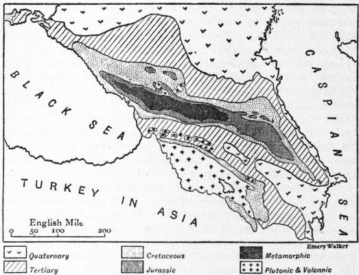
Geology.—The general structure of the Caucasus is comparatively simple. The strata are folded so as to form a fan. In the centre of the fan lies a band of crystalline rocks which disappears towards the east. Beneath it, on both sides, plunge the strongly folded Palaeozoic and Jurassic schists. On the northern flank the folded beds are followed by a zone of Jurassic and Cretaceous beds which rapidly assume a gentle inclination towards the plain. On the south the corresponding zone is affected by numerous secondary folds which involve the Sarmatian or Upper Miocene deposits. In the eastern part of the chain the structure is somewhat modified. The crystalline band is lost. The northern Mesozoic zone is very much broader, and is thrown into simple folds like those of the Jura. The southern Mesozoic zone is absent, and the Palaeozoic zone sinks abruptly in a series of faulted steps to the plain of the Kura, beneath which no doubt the continuation of the Mesozoic zone is concealed.
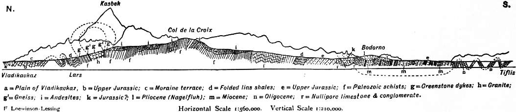
The geological sequence begins with the granite and schists of the central zone, which form a band extending from Fisht on the west to a point some distance beyond Kasbek on the east. Then follow the Palaeozoic schists and slates. Fossils are extremely rare in these beds; Buthotrephis has long been known, and doubtful traces of Calamites and ferns have been found, but it was not until 1897 that undoubted Palaeozoic fossils were obtained. They appear to indicate a Devonian age. Upon the Palaeozoic beds rest a series of Mesozoic deposits, beginning with the Lias and ending with the Upper Cretaceous. Whether the series is continuous or not is a matter of controversy. F. Loewinson-Lessing states that there is a more or less marked discordance between the Lias and the Upper Jurassic and between the latter and the Cretaceous; E. Fournier asserts that there exists a very strongly marked unconformity at the base of the Tithonian, and other writers have expressed other views. In general the Upper ajurassic beds are much more calcareous on the north flank of the chain than they are on the south. The Mesozoic beds are followed by the Tertiary deposits, which on the north are nearly horizontal but on the south are in part included in the folds—the Eocene and Miocene being folded, while the later beds, though sometimes elevated, are not affected by the folding. The final folding of the chain undoubtedly occurred at the close of the Miocene period. That there were earlier periods of folding is almost equally certain, but there is considerable difference of opinion as to their dates. The difference in character of the Jurassic beds on the two sides of the chain appears to indicate that a ridge existed in that period. The last phase in the history of the Caucasus was marked by the growth of the great volcanoes of Elbruz and Kasbek, which stand upon the old rocks of the central zone, and by the outflow of sheets of lava upon the sides of the chain. The cones themselves are composed largely of acid andesites, but many of the lavas are augite andesites and basalts. There seem to have been two periods of eruption, and as some of the lavas have flowed over Quaternary gravels, the latest outbursts must have been of very recent date.
Near the northern foot of the Caucasus, especially in the neighbourhood of the hot mineral springs of Pyatigorsk, a group of hills of igneous rocks rises above the plain. They are laccolites of trachytic rock, and raised the Tertiary beds above them in the form of blisters. Subsequent denudation has removed the sedimentary covering and exposed the igneous core.
(P. La.)
Bibliography.—Of the older works the following are still useful: A. von Haxthausen, Transkaukasia (2 vols., Leipzig, 1856); A. Petzholdt, Der Kaukasus (2 vols., Leipzig, 1866-1867); M.G. von Thielmann, Travels in the Caucasus (Eng. trans., 2 vols., London, 1875); F.C. Grove, The Frosty Caucasus (London, 1875); G. Radde, Reisen im mingrelischen Hochgebirge (Tiflis, 1866) and Vier Vorträge uber den Kaukasus (Gotha, 1874); E. Favre, Recherches géologiques dans la partie centrale de la chaîne du Caucase (Geneva, 1875); Batsevich, Simonovich and others, Mat. dlya geologiy Kavkaza (Tiflis, 1873 seq.); O. Schneider, Naturwissenschaftliche Beitrage zur Kenntnis der Kaukasuslander (Dresden, 1879), and J. Bryce, Transcaucasia (London, 1878). The more important amongst the more recent books are D.W. Freshfield, Exploration of the Caucasus (2nd ed., 1902, 2 vols., London); A.F. Mummery, My Climbs in the Alps and Caucasus (London, 1895); H. Abich, Geologische Forschungen in den kaukasischen Landern (3 vols., Vienna, 1878-1887), Aus kaukasischen Landern (2 vols., Vienna, 1896), and “Vergleichende Grundzuge des Kaukasus wie der armenischen und nordpersischen Gebirge,” in Mém. Acad. Sc. St-Pétersb. (sér. 6, Math. et Phys., vii. 359-534); R. von Erckert, Der Kaukasus und seine Volker (Leipzig, 1887); E. Chantre, Recherches anthropologiques dans le Caucase (4 vols., Lyons and Paris, 1885-1887); C. von Hahn, Aus dem Kaukasus (Leipzig, 1892), Kaukasische Reisen und Studien (Leipzig, 1896), and Bilder aus dem Kaukasus (Leipzig 1900); V. Sella and D. Vallino, Nel Caucaso Centrale (Turin, 1890); K. Koch, Der Kaukasus (Berlin, 1882); C. Phillipps Woolley, Savage Svanetia (2 vols., London, 1883); E. Levier, À travers le Caucase (Paris, ed. 1905), especially valuable for botany; G. Merzbacher, Aus den Hochregionen des Kaukasus (2 vols., Leipzig, 1901); A. Fischer, Zwei Kaukasische Expeditionen (Berne, 1891); E. Fournier, Description géologique du Caucase central (Marseilles, 1896); G. Radde, Reisen an der persisch-russischen Grenze. Talysch und seine Bewohner (Leipzig, 1886), Die Fauna und Flora des südwestlichen Kaspigebiets (Leipzig, 1886), Karabagh (Gotha, 1890), and Aus den daghestanischen Hochalpen (Gotha, 1887); and Count J. Zichy, Voyages au Caucase (2 vols., Budapest, 1897). F. Loewinson-Lessing has an account of the geology of the district along the military road from Vladikavkaz to Tiflis in the Guide des Excursions du VIIe Congrès géol. internat. (St Petersburg, 1897). N.Y. Dinnik writes on the fauna in Bull. Soc. Impériale des Naturalistes de Moscou (1901); J. Mourier on the folk-tales in Contes et légendes du Caucase (1888); and on modern history G. Baumgarten, Sechzig Jahre des kaukasischen Krieges (Leipzig, 1861). But a very great amount of most valuable information about the Caucasus is preserved in articles in encyclopaedias and scientific periodicals, especially the Izvestia and Zapiski of the Russian and Caucasian geographical societies, in P.P. Semenov’s Geographical Dictionary (in Russian, 5 vols., St Petersburg, 1863-1884), and in the Russkiy encyklopedicheskiy slovar (1894), and in the Kavkazskiy kalendar (annually at Tiflis). See also G. Radde and E. Koenig, “Der Nordfuss des Daghestan und das vorlagernde Tiefland bis zur Kuma” (Ergänzungsheft No. 117 to Petermanns Mitteilungen), and “Das Ostufer des Pontus und seine kulturelle Entwickelung im Verlaufe der letzten 30 Jahre” (Ergänzungsheft No. 112 of the same); by V. Dingelstedt in Scot. Geog. Mag.—”Geography of the Caucasus” (July 1889); “The Caucasian Highlands” (June 1895); “The Hydrography of the Caucasus” (June 1899); “The Riviera of Russia” (June 1904), “The Small Trades of the Caucasus” (March 1892); and “Caucasian Idioms” (June 1888). The best map is that of the Russian General Staff on the scale of 1 : 210,000 (ed. 1895-1901).
(J. T. Be.; P. A. K.)
1 Exploration of the Caucasus (2nd ed., 1902), i. 30-31.
2 Op. cit. i. 35-36.
CAUCHOIS-LEMAIRE, LOUIS FRANÇOIS AUGUSTE (1789-1861), French journalist, was born in Paris on the 28th of August 1789. Towards the end of the First Empire he was proprietor of the Journal de la littérature et des arts, which he transformed at the Restoration into a political journal of Liberal tendencies, the Nain jaune, in which Louis XVIII. himself had little satirical articles secretly inserted. After the return from Elba the Nain jaune became Bonapartist and fell into discredit. It was suppressed at the second Restoration. Cauchois-Lemaire then threw himself impetuously into the Liberal agitation, and had to take refuge in Brussels in 1816, and in the following year at the Hague, whence he was expelled for publishing an Appel à l’opinion publique et aux États Généraux en faveur des patriotes français. Returning to France in 1819, he resumed the struggle against the ultra-royalist party with such temerity that he was condemned to one year’s imprisonment in 1821 and fifteen months’ imprisonment in 1827. After the revolution of July 1830 he refused a pension of 6000 francs offered to him by King Louis Philippe, on the ground that he wished to retain his independence even in his relations with a government which he had helped to establish. He made a bitter attack upon the Périer ministry in his journal Bon sens, and in 1836 was one of the founders of a new opposition journal, the Siècle. He soon, however, abandoned journalism for history and, having no private means, in 1840 accepted the post of head of a department in the Royal Archives. Of a Histoire de la Révolution de Juillet, which he then undertook, he published only the first volume (1842), which contains a historical summary of the Restoration and a preliminary sketch of the democratic movement. He died in Paris on the 9th of August 1861.
CAUCHON, PIERRE (d. 1442), French bishop, was born near Reims in the latter half of the 14th century. We find him rector of the university of Paris in October 1397. In 1413 he joined the Burgundian faction, and was exiled by the parlement of Paris. But on the triumph of his party this decree was annulled, and Philip the Good, duke of Burgundy, gave him a canonry at Beauvais, sent him to the council of Constance, procured him the post of maître des requêtes in 1418, and finally in 1420 had him made bishop of Beauvais. But the people were hostile to him, and he was driven from his bishopric in 1429; whereupon he attached himself to the English court, and in 1431 endeavoured to procure the surrender of Reims to the English, so that Henry VI. might be crowned there. In this he failed, and Henry was crowned in Paris on the 17th of December 1431 by Henry Beaufort, cardinal bishop of Winchester, assisted by the bishops of Beauvais and Noyon. On the 24th of May 1430, Joan of Arc having been taken prisoner at Compiègne, within the limits of his diocese, Cauchon acted as her accuser, and demanded the right of judging her. Joan was taken to Rouen, whither Cauchon followed her, having been driven from Beauvais. He conducted the trial with marked partiality and malevolence, condemned the maid to imprisonment for life, and then, under pressure from the populace and the English, had recourse to fresh perfidies, declared Joan a relapsed heretic, excommunicated her, and handed her over to the secular arm on the 30th of May 1431. As, in consequence of this, it was impossible for him to return to his own diocese, he obtained the bishopric of Lisieux in 1432 by favour of the king of England. He assisted at the council of Basel in 1435, and died suddenly on the 18th of December 1442. Excommunicated posthumously by Pope Calixtus IV., his body was exhumed and thrown in the common sewer.
See Cerf, “Pierre Cauchon de Sommièvre, chanoine de Reims et de Beauvais, évêque de Beauvais et de Lisieux, son origine, ses dignités, sa mort et sa sépulture,” in the Transactions of the Academy of Reims (1896-1898).
CAUCHY, AUGUSTIN LOUIS, Baron (1789-1857), French mathematician, was born at Paris on the 21st of August 1789, and died at Sceaux (Seine) on the 23rd of May 1857. Having received his early education from his father Louis François Cauchy (1760-1848), who held several minor public appointments and counted Lagrange and Laplace among his friends, Cauchy entered École Centrale du Panthéon in 1802, and proceeded to the École Polytechnique in 1805, and to the École des Ponts et Chaussées in 1807. Having adopted the profession of an engineer, he left Paris for Cherbourg in 1810, but returned in 1813 on account of his health, whereupon Lagrange and Laplace persuaded him to renounce engineering and to devote himself to mathematics. He obtained an appointment at the École Polytechnique, which, however, he relinquished in 1830 on the accession of Louis Philippe, finding it impossible to take the necessary oaths. A short sojourn at Freiburg in Switzerland was followed by his appointment in 1831 to the newly-created chair of mathematical physics at the university of Turin. In 1833 the deposed king Charles X. summoned him to be tutor to his grandson, the duke of Bordeaux, an appointment which enabled Cauchy to travel and thereby become acquainted with the favourable impression which his investigations had made. Charles created him a baron in return for his services. Returning to Paris in 1838, he refused a proffered chair at the Collège de France, but in 1848, the oath having been suspended, he resumed his post at the École Polytechnique, and when the oath was reinstituted after the coup d’état of 1851, Cauchy and Arago were exempted from it. A profound mathematician, Cauchy exercised by his perspicuous and rigorous methods a great influence over his contemporaries and successors. His writings cover the entire range of mathematics and mathematical physics.
Cauchy had two brothers: Alexandre Laurent (1792-1857), who became a president of a division of the court of appeal in 1847, and a judge of the court of cassation in 1849; and Eugène François (1802-1877), a publicist who also wrote several mathematical works.
The genius of Cauchy was promised in his simple solution of the problem of Apollonius, i.e. to describe a circle touching three given circles, which he discovered in 1805, his generalization of Euler’s theorem on polyhedra in 1811, and in several other elegant problems. More important is his memoir on wave-propagation which obtained the Grand Prix of the Institut in 1816. His greatest contributions to mathematical science are enveloped in the rigorous methods which he introduced. These are mainly embodied in his three great treatises, Cours d’analyse de l’École Polytechnique (1821); Le Calcul infinitésimal (1823); Leçons sur les applications du calcul infinitésimal à la géométrie (1826-1828); and also in his courses of mechanics (for the École Polytechnique), higher algebra (for the Faculté des Sciences), and of mathematical physics (for the Collège de France). His treatises and contributions to scientific journals (to the number of 789) contain investigations on the theory of series (where he developed with perspicuous skill the notion of convergency), on the theory of numbers and complex quantities, the theory of groups and substitutions, the theory of functions, differential equations and determinants. He clarified the principles of the calculus by developing them with the aid of limits and continuity, and was the first to prove Taylor’s theorem rigorously, establishing his well-known form of the remainder. In mechanics, he made many researches, substituting the notion of the continuity of geometrical displacements for the principle of the continuity of matter. In optics, he developed the wave theory, and his name is associated with the simple dispersion formula. In elasticity, he originated the theory of stress, and his results are nearly as valuable as those of S.D. Poisson. His collected works, OEuvres complètes d’Augustin Cauchy, have been published in 27 volumes.
See C.A. Valson, Le Baron Augustin Cauchy: sa vie et ses travaux (Paris, 1868).
CAUCUS, a political term used in America of a special form of party meeting, and in Great Britain of a system of party organization. The word originated in Boston, Massachusetts, in the early part of the 18th century, when it was used as the name of a political club, the “Caucus” or “Caucas” club. Here public matters were discussed, and arrangements made for local elections and the choosing of candidates for offices. The first mention of the club in contemporary documents occurs in the diary of John Adams in 1763, but William Gordon (History of the Independence of the United States of America, 1788) speaks of the Caucus as having been in existence some fifty years before the time of writing (1774), and describes the methods used for securing the election of the candidates the club had selected. The derivation of the word has been much disputed. It was early connected with “caulkers,” and it was supposed referred to meetings of the caulkers in the dockyard at Boston in 1770, to protest against the action of the British troops, or with a contemptuous allusion to the lower class of workmen frequenting the club. This is, however, a mere guess, and does not agree with the earlier date at which the club is known to have existed, nor with the accounts given of it. That it was a fanciful classical name for a convivial club, derived from the late Greek καῦκος, a cup, is far-fetched, and the most plausible origin is an Algonquin word kaw-kaw-was, meaning to talk. Indian words and names have been popular in America as titles for societies and clubs; cf. “Tammany” (see Notes and Queries. sixth series, vols. xi. and xii.). In the United States “caucus” is used strictly of a meeting either of party managers or of party voters. Such might be a “nominating caucus,” either for nominating candidates for office or for selecting delegates for a nominating convention. The caucus of the party in Congress nominated the candidates for the offices of president and vice-president from 1800 till 1824, when the convention system was adopted, and the place of the local “nominating caucus” is taken by the “primaries” and conventions. The word is used in America of the meetings of a party in Congress and other legislative bodies and elsewhere which decide matters of policy and plan campaigns. “Caucus” came first into use in Great Britain in 1878. The Liberal Association of Birmingham (see Liberal Party) was organized by Mr Joseph Chamberlain and Mr F. Schnadhorst on strict disciplinary lines, more particularly with a view to election management and the control of voters on the principle of “vote as you are told.” This managing body of the association, known locally as the “Six Hundred,” became the model for other Liberal associations throughout the country, and the Federation of Liberal Associations was organized on the same plan. It was to this supposed imitation of the American political “machine” that Lord Beaconsfield gave the name “caucus,” and the name came to be used, not in the American sense of a meeting, but of a closely disciplined system of party organization, chiefly used as a stock term of abuse applied by opponents to each other’s party machinery.
CAUDEBEC-EN-CAUX, a town of France, in the department of Seine-Inférieure, 27 m. W.N.W. of Rouen by the Ouest-État railway. Pop. (1906) 2141. It is situated on the right bank of the Seine, the tidal wave of which (mascaret) can be well seen at this point. The chief interest of the town lies in its church, a building of the 15th and the early 16th centuries. Round its top run balustrades formed of Gothic letters, which read as part of the Magnificat. Its west portal, the decoration of the spire of the tower, and its stained glass are among the features which make it one of the finest churches of the Rouen diocese. The town also possesses several old houses. Its industries include tanning and leather-currying, and there is trade in grain. The port has a small trade in coal, live-stock and farm produce.
CAUDINE FORKS (Furculae Caudinae), a pass in Samnium, famous for the disaster which befell the Roman army in the second Samnite War (321 b.c.). Livy (ix, 2) describes it as formed by two narrow wooded gorges, between which lay a plain, grassy and well-watered, but entirely enclosed by mountains. Through this plain the road (later the Via Appia) led. The Romans, marching from Calatia to the relief of Luceria, entered the valley unopposed, but found the exit blocked by the enemy; on marching back they saw that the entrance and the hills surrounding the plain were also occupied, and there was no way of escape. The plain which lies west of Caudium (Montesarchio) seems, despite the older views, to be the only possible site for such a disaster to an army of as many as 40,000 men; and there is no doubt that the Romans wished to leave it by the defile on the east, through which later ran the Via Appia to Beneventum. The existence of three ancient bridges on the line of the modern road renders it impossible to suppose that its course can be essentially different from that of the ancient, though Hülsen makes the two diverge considerably after passing Montesarchio. There are, however, two possible entrances—one on the north by Moiano, and one on the west by Arpaia; the former seems to answer better to Livy’s description (via alia per cavam rupem), while the latter is the shortest route, having been, later on, followed by the Via Appia, and bore the name Furculae Caudinae in the middle ages.
See C. Hülsen in Pauly-Wissowa, Realencyclopädie, iii. (1802).
(T. As.)
CAUDLE (through the O. Fr. caudel, from the Med. Lat. caldellum, a diminutive of caldum, a warm drink, from calidus, hot), a drink of warm gruel, mixed with spice and wine, formerly given to women in childbed.
CAUL (from O. Eng. calle, Fr. cale, a cap), a close-fitting woman’s cap, especially one made of network worn in the 16th and 17th centuries; hence the membranous covering to the heart or brain, the omentum, or the similar covering to the intestines, and particularly, a portion of the amnion, which is sometimes found remaining round the head of a child after birth. To this, called in Scotland “sely how,” holy or lucky hood, many superstitions have been attached; it was looked on as a sign of good luck, and when preserved, was kept as a protection against drowning.
CAULAINCOURT, ARMAND AUGUSTIN LOUIS, Marquis de (1773-1827), French general and diplomatist, was born of a noble family. He early entered the army, did not emigrate in the revolution, but was deprived of his grade as captain in 1793 and served in the ranks. In 1795, through the protection of L. Hoche, he became captain again, was colonel in the Army of the Rhine in 1799-1800, and after the peace of Lunéville (1801) was sent to St Petersburg to negotiate an understanding between Russia and France. On his return he was named aide-de-camp of the First Consul. He was employed to seize some agents of the English government in Baden in 1804, which led to the accusation that he was concerned in the arrest of the due d’Enghien, an accusation against which he never ceased to protest. After the establishment of the empire he received various honours and the title of duke of Vicenza (1808). Napoleon sent him in 1807 as ambassador to St Petersburg, where Caulaincourt tried to maintain the alliance of Tilsit, and although Napoleon’s ambition made the task a difficult one, Caulaincourt succeeded in it for some years. In 1811 he strongly advised Napoleon to renounce his proposed expedition to Russia. During the war he accompanied the emperor, and was one of those whom Napoleon took along with him when he suddenly abandoned his army in Poland to return to Paris (December 1812). During the last years of the empire, Caulaincourt was charged with all the diplomatic negotiations. He signed the armistice of Pleswitz, June 1813, represented France at the congress of Prague, in August 1813, at the congress of Chatillon, in February 1814, and concluded the treaty of Fontainebleau on the 10th of April 1814. During the first Restoration, Caulaincourt lived in obscure retirement. When Napoleon returned from Elba, he became minister of foreign affairs, and tried to persuade Europe of the emperor’s peaceful intentions. After the second Restoration, Caulaincourt’s name was on the list of those proscribed, but it was erased on the personal intervention of Alexander I. with Louis XVIII.
Caulaincourt’s memoirs appeared under the title Souvenirs du duc de Vicence in 1837-1840. See A. Vandal, Napoléon et Alexandre (Paris, 1891-1895); Tatischeff, Alexandre Ier et Napoleon (Paris, 1892); H. Houssaye, 1814 (Paris, 1888), and 1815 (Paris, 1893).
CAULICULUS (from Lat. caulis, a stalk), in architecture, the Stalks (eight in number) with two leaves from which rise the helices or spiral scrolls of the Corinthian capital to support the abacus.
CAULON (Gr. καυλωνία), a town of the district of the Bruttii, Italy, on the east coast. Its exact site is uncertain (though the name has been given to a modern village), and depends on the identification of the river Sagras. It was the southernmost of the Achaean colonies, founded either by Croton or direct from Greece itself. In the 7th century it was allied with Croton and Sybaris, and its coins, which go back to 550 b.c., prove its importance. It took the side of Athens in the Peloponnesian War. In 388 b.c. it was destroyed by Dionysius, but soon afterwards restored. It was captured during the invasion of Pyrrhus by Campanian troops. Strabo speaks of it as deserted in his time. The erection of the lighthouse at Capo Stilo, on the site of one of the medieval guard towers of the coast, led to the discovery of a wall of Greek origin, and close by of a number of terra-cottas, belonging perhaps to a temple erected in honour of the deities of the sea. Other remains were found at Fontanelle, 2½ m. away, including the fragment of a capital of an archaic Greek temple (P. Orsi in Notizie degli Scavi, 1891, 61). These buildings may be connected with the Caulon or a village dependent on it.
(T. As.)
CAUSATION or Causality (Lat. causa, derived perhaps from the root cav-, as in caveo, and meaning something taken care of; corresponding to Gr. αἰτία), a philosophical term for the operation of causes and for the mental conception of cause as operative throughout the universe. The word “cause” is correlative to “effect.” Thus when one thing B is regarded as taking place in consequence of the action of another thing A, then A is said to be the cause of B, and B the effect of A. The philosophical problems connected with causation are both metaphysical and psychological. The metaphysical problem is part of the whole theory of existence. If everything is to be regarded as causally related with simultaneous and prior things or actions, it follows logically that the investigation of existence must, by hypothesis, be a regress to infinity, i.e. that we cannot conceive a beginning to existence. This explanation has led to the postulate of a First Cause, the nature of which is variously explained. The empirical school sees no difficulty in assuming a single event; but such a theory seems to deny the validity of the original hypothesis. Theologians assert a divine origin in the form of a personal self-existent creator, while some metaphysical schools, preferring an impersonal First Cause, substitute the doctrine of the Absolute (q.v.). All the explanations are alike in this respect, that at a certain point they pass from the sphere of the senses, the physical world, to a metaphysical sphere in which the data and the intellectual operation of cognizing them are of a totally different quality. For example, the causal connexion between drunkenness and alcohol is not of the same observable character as that which is inferred between the infinite First Cause and the whole domain of sense-given phenomena.
A second metaphysical problem connected with causation arises when we consider the nature of necessity. It is generally assumed when two things are spoken of as cause and effect that their relation is a necessary one, or, in other words, that given the cause the effect must follow. The arguments connected with this problem belong to psychological discussions of causation. It is sufficient here to state that, in so far as causation is regarded as necessary connexion, it can form no part of a purely empirical theory of existence. The senses can say only that in all observed cases B has followed A, and this does not establish necessary connexion. The idea of causation is a purely intellectual (a priori) one.
The psychological problems connected with causation refer (1) to the origin of the conception in our minds; (2) to the validity of the conception. As regards the origin of the conception modern psychological analysis does not carry us beyond the doctrine of Locke contained in his chapter on “Power” (Essay, bk. ii. ch. 21), wherein he shows that the idea of power is got from the knowledge of our own activity. “Bodies by their causes,” he says, “do not afford us so clear and distinct an idea of active power as we have from reflection on the operation of our minds.” Putting Locke’s doctrine into modern language, we may say that a man has the conception of cause primarily because he himself is a cause. The conception thus obtained we “project,” that is, transfer to external objects, so far as we may find it useful to do so. Thus it is by a sort of analogy that we say that the sun is the “cause” of daylight. The rival theory to Locke’s is that of Hume (Treatise, bk. i.), who derives the conception from the unaided operation of custom. When one object, A, has been noticed frequently to precede another object, B, an association between A and B is generated; and by virtue of this association, according to Hume, we say that A is the cause of B. The weakness of this account is that many invariable successions, such as day and night, do not make us regard the earlier members of the successions as causing the later; while in numberless cases we assert a causal connexion between two objects from a single experience of them.
We may proceed now to consider the validity of the conception of causation, which has been attacked from two sides. From the side of absolute idealism it is argued that the conception of cause, as involving a transition in time, cannot be ultimately valid, since the time-relation is not ultimately real. Upon this view (ably stated in Professor Bosanquet’s Logic, bk. i. ch. 6) the more we know of causes and effects the less relevant becomes the time-relation and the nearer does the conception of cause and effect approach to another conception which is truly valid, the conception of ground and consequence. This means that, viewed from the standpoint of science, a draught of alcohol causes intoxication in no other sense than the triangularity of a triangle causes the interior angles to be equal to two right angles. This argument ceases to have cogency so soon as we deny its fundamental proposition that the time-relation is not ultimately real, but is irrelevant from the standpoint of science. This is a sheer assertion, contrary to all ordinary experience, which we have as much right to deny as the absolute idealists to affirm. It is only plausible to those who are committed to the Hegelian view of reality as consisting of a static system of universals, a view which has long been discredited in Germany, its native land, and is fast losing ground in England. Against the Hegelians we must maintain that the common distinction between “ground” and “cause” is perfectly justifiable. Whereas “ground” is an appropriate term for the relations within a static, simultaneous system, “cause” is appropriate to the relations within a dynamic, successive system.