Volume 3 — [E-Text Edition of Volume III - Part 1 of 2, Slice 2 of 3 - BACONTHORPE to BANKRUPTCY] (continued 5)
Reading edition
The old Irish Bag-pipe.—Very little is known about this instrument. It is mentioned in the ancient Brehon Laws, said to date from the 5th century (they are cited in compilations of the 10th century), in describing the order of precedence of the king's bodyguard and household in the Crith Gabhlach: "Poets, harpers, pipers, horn-blowers and jugglers have their place in the south-east part of the house."[12] The word used for (bag-) pipers is Cuislennaïgh, a word associated with reed instruments (cuiscrigh = reeds; O'Reilly's Irish-English Dictionary, Dublin, 1864). The old Irish bag-pipe, of which we possess an illustration dated 1581,[13] had a long conical chaunter with a bell and apparently seven holes in front and a thumb-hole behind; there were two drones of different lengths—one very long—both set in the same stock. It is exceedingly difficult to procure any accurate information concerning the development of the bag-pipe in Ireland until it assumed the present form, known as the union-pipes, which belong to Class II.
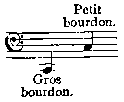
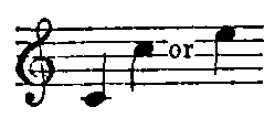
The cornemuse and chalemie were the bag-pipes in use in France, Italy and the Netherlands before the advent of the musette, to which they bear the same relation as the old Irish bag-pipe does to the union-pipes, or the cornemusa or piva to the sampogna or surdelina in Italy. Two kinds of cornemuses were known in France during the 16th and 17th centuries, differing in one important structural detail, which affected the timbre of the instruments. Père Marin Mersenne[14] has given a detailed description of these varieties and of the musette, with very clear illustrations of the instruments and all their parts. The cornemuse or chalemie used by shepherds, and as a solo instrument (see fig. 1 (1)), was similar to the Highland bag-pipe; it consisted of a leather bag, inflated by means of a valved blow-pipe; a large drone (gros bourdon) 2½ ft. long included the beating-reed, which measured 2½ in., and was fixed in the stock; the small drone (petit bourdon), 1 ft. in length including a reed 2 in. long, also had a beating-reed and was fixed in the same stock as the chaunter. The two drones were tuned to C. The chaunter had a conical bore and a double reed like an oboe, but hidden within the stock; it could be taken out and played separately, when the compass given by the eight holes (seven in front and a thumb-hole) C to C′ could be increased by a third to E, by overblowing the D and E an octave by pressure of the breath and lips on the reed, now taken directly into the mouth. The second kind of cornemuse was played only in concert with a family of instruments known as Hautbois de Poitou, a hautbois having the reed enclosed in an air-chamber, just as is the case with the reeds of the bag-pipe. This cornemuse had but one drone which could, like the others, be lengthened for tuning by drawing out the joint; the reed was not a beating-reed but a double reed like that of the chaunter; this constitutes the main difference between the two cornemuses. The chaunter had eight holes, the lowest of which was covered by a key enclosed in a perforated box.
Sackpfeife or Dudelsack.
Bock.
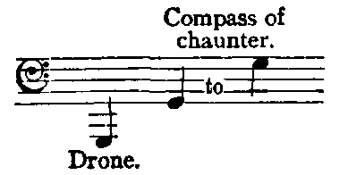
The Sackpfeife or Dudelsack of Germany was an instrument of some importance made in no less than five sizes, all described and illustrated by Michael Praetorius.[15] They consist of the Grosser Bock or double-bass bag-pipe, a formidable-looking instrument with a single cylindrical drone of a great length, terminating, as did the chaunter also, in a curved ram's horn (to which the name was due). The chaunter had seven finger-holes and a vent-hole in front, and a thumb-hole at the back. The drone was tuned to G, an octave below the chaunter.
The Bock, of similar construction, was pitched a fourth higher in C.
Schäferpfeife.
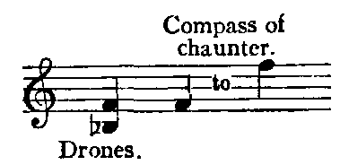
Hümmelchen.
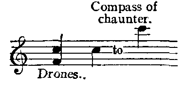
The Schäferpfeife had two drones in B flat and F. Praetorius explains that the upper notes of the chaunter of this sackpfeife had a faulty intonation which could not be corrected owing to the absence of the thumb-hole, usual in all other varieties of the instrument.
The Hümmelchen had two drones tuned to F and C.
The Dudey or treble sackpfeife was the smallest of the family, and had three drones tuned to E flat, B flat and E flat, and a chaunter with a compass ranging from F or E flat to C or D.

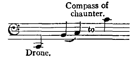
Praetorius also mentions a different kind of sackpfeife he saw in Magdeburg (see op. cit. Theatrum, pl. v., No. 4), which was somewhat larger than the schäferpfeife and pitched a third lower. There were two chaunters mounted in one stock, each having three holes in front and one for the thumb at the back. The right-hand chaunter sounded the five notes D, E, F, G, A, and the left-hand chaunter, G, A, B, C, D. The performer was thus able to play simple two-part melodies on the Magdeburg bag-pipe. Praetorius mentions in addition the French bag-pipe (musette), similar in pitch to the hümmelchen, but inflated by means of the bellows.
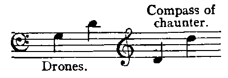
The Calabrian bag-pipe has a bag of goatskin with the hair left on, and is inflated by means of a blow-pipe. There are two drones and two chaunters, all fixed in one stock. Each chaunter has three or four finger-holes and the right-hand pipe has the fourth covered by a key enclosed in a perforated box; both drones and chaunter have double reeds.
The ancient Greek bag-pipe (see Askaules), and the Roman tibia utricularis, belonged to this class of instrument, inflated by the mouth, but it is not certain that they had drones (see below, History).
II. The second class of instruments, inflated by means of a small bellows worked by the arm, has as prototype the musette (see fig. 1 (3)), which is said to have been evolved during the 15th century;[16] from the end of the 15th century there were always musette players[17] at the French court, and we find the instrument fully developed at the beginning of the 17th century when Mersenne[18] gives a full description of all its parts. The chief characteristic of the musette was a certain rustic Watteau-like grace. The face of the performer was no longer distorted by inflating the bag; for the long cumbersome drones was substituted a short barrel droner, containing the necessary lengths of tubing for four or five drones, reduced to the smallest and most compact form. The bores were pierced longitudinally through the thickness of the wood in parallel channels, communicating with each other in twos or threes and providing the requisite length for each drone. The reeds were double "hautbois" reeds all set in a wooden stock or box within the bag; by means of regulators or slides, called layettes, moving up and down in longitudinal grooves round the circumference of the barrel, the length of the drone pipes could be so regulated that a simple harmonic bass, consisting mainly of the common chord, could be obtained. The chaunter, of narrow cylindrical bore, was also furnished with a double reed and had eleven holes, four of which had keys, giving a compass of twelve notes from F to C. This number of holes was not invariable. After Mersenne's time, Jean Hotteterre (d. 1678), a court musician, belonging to the band known as the Musique de la Grande Écurie,[19] in which he played the dessus de hautbois, introduced certain improvements in the drones of the musette.[20] His son Martin Hotteterre (d. 1712) added a second chaunter to the musette, shorter than the first, to which it was attached instead of being inserted into the stock. The Hotteterre chaunter, known as le petit chalumeau, had six keys, whereas the grand chalumeau had seven, besides eight finger-holes and a vent-hole in the bell. All these keys were actuated by the little finger of the left hand and the thumb of the right hand, which were not required to stop holes on the large chaunter. The grand and petit chalumeaux are figured in detail with keys and holes in a rare and anonymous work by Borjon (or Bourgeon[21]), who gives much interesting information concerning one of the most popular instruments of his day. The bellows, he states, borrowed from the organ, were added to the musette about forty or fifty years before he wrote his treatise. The compass of the improved musette of Hotteterre was as shown:—
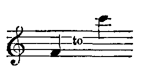
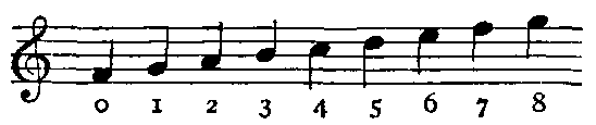
the eight holes of the grand chalumeau.
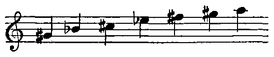
the seven keys of the grand chalumeau.
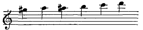
the six keys of the petit chalumeau.
The four or five drones were usually tuned thus:
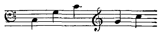
The chaunters and drones were pierced with a very narrow cylindrical bore, and double reeds were used throughout, causing them to speak as closed pipes, which accounts for the deep pitch of these relatively short pipes (see Aulos). Martin Hotteterre was hardly the first to introduce the second chaunter for the bag-pipe, since Praetorius in 1618 figures and describes the Magdeburg sackpfeife with two chaunters, but without keys and with a conical bore.
The surdelina or sampogna is described and illustrated by Mersenne[22] as the musette de Naples; its construction was very complicated. Mersenne states that the instrument was invented by Jean Baptiste Riva (who was living in Paris in 1620), Dom Julio and Vincenze; but Mersenne seems to have made alterations himself in the original instrument, which are not very clearly explained. There were two chaunters with narrow cylindrical bore and having both finger-holes and keys; and two drones each having ten keys. The four pipes were fixed in the same stock, and double reeds were used throughout; the bag was inflated by means of bellows. Passenti of Venice published a collection of melodies for the zampogna in 1628, under the title of Canora Zampogna.
The modern Lowland bag-pipe differs from the Highland bag-pipe mainly in that it is blown by bellows instead of by the mouth.
The Northumbrian or Border bag-pipe, also blown by means of bellows, is chiefly distinguished by having a chaunter stopped at the lower end so that when all the holes are closed, the pipe is silent. There are seven finger-holes, one for the thumb, and a varying number of keys. The four drones are fixed in one stock and are tuned by means of stoppers, so that, as in the musette, any one of them may be silenced. A fine Northumbrian bag-pipe[23] from the collection of the Rev. F. W. Galpin is illustrated (fig. 1. (5)).
The union pipes of the 18th century, or modern Irish bag-pipe, blown by bellows (see fig. 1. (2)), had one chaunter with seven finger-holes, one thumb-hole and eight keys, which together gave the chromatic scale in two octaves. The drones were tuned to A in different octaves, and three regulators or drones with keys, played by the elbow, produced a kind of harmony; the regulators correspond to the sliders on the drone-barrel of the musette.
History of the Bag-pipe.—There is reason to believe that the origin of the bag-pipe must be sought in remote antiquity. No instrument in any degree similar to it is represented on any of the monuments of Egypt or Assyria known at the present day; we are, nevertheless, able to trace it in ancient Persia and by inference in Egypt, in Chaldaea and in ancient Greece. The most characteristic feature of the bag-pipe is not the obvious bag or air-reservoir from which the instrument derives its name in most languages, but the fixed harmony of the buzzing drones. The principle of the drone, i.e. the beating-reed sunk some three inches down the pipe, was known to the ancient Egyptians. In a pipe discovered in a mummy-case and now in the museum at Turin, was found a straw beating-reed in position. The arghoul (q.v.), a modern Egyptian instrument, possesses the characteristic feature of drone and chaunter without the bag. The same instrument occurs once in the hieroglyphs, being sounded as-it, and once on a mural painting preserved in the Musée Guimet and reproduced by Victor Loret.[24] During Jacques de Morgan's excavations in Persia some terracotta figures of musicians, dating from the 8th century B.C., were discovered in a tell (mound) at Susa,[25] two of which appear to be playing bag-pipes; the chaunter, curved in the shape of a hook from the stock, is clearly visible, the bag under the arm is indicated, and the lips are pursed as if in the act of blowing, but the insufflation tube is absent; a round hole in one of the figures suggests its presence formerly.
Among the names of musical instruments in Daniel iii. 5 and 15, the sixth, generally but wrongly rendered "dulcimer," is thought by many scholars to signify a kind of bag-pipe (see commentaries on Daniel and the theological encyc.). This belief is based on the supposition that the Aramaic sumpōnyā is a loan-word from the Greek, being a mispronunciation of συμφονία. The argument is, however, exceedingly weak. In the first place, the date of the book of Daniel is matter of controversy, hingeing partly on precisely such questions as the true significance and derivation of sumpōnyā. Second, it is possible that the word sumpōnyā is a late interpolation. Third, its exact form is uncertain; in verse 10, sippōnyā is used of the same instrument, suggesting a derivation from the Gr. σίφον (tube or pipe). Fourth, even if συμφονία is the source of the word, there is very little evidence that it was used for any particular instrument. The original natural sense of συμφονία is "concord of sound," "a concordant interval," and the evidence of its use for a particular instrument is of the 2nd century B.C., and, even so, very slight. Only one passage (Polyb. xxvi. 10. 5) really bears on the question, and there the translation of the word depends on a context the reading of which is uncertain (see Symphonia). It is, however, curious that the bag-pipe was known in Italy and Spain during the middle ages, the two countries through which Eastern culture was introduced into Europe, by the name of zampogna or sampogna, which strongly recall the Chaldaean sumpōnyā; and further that in the same countries the word sinfonia should be coexistent with zampogna and have the original meaning attached to the classical συμφονία, "a concord of sound." A single passage only in Dion Chrysostom (see Askaules) is enough to prove that the instrument was known in Greece in A.D. 100.[26] The Greeks had undoubtedly received some kind of bag-pipe from Egypt (in the form of the as-it), or from Chaldaea, but it remained a rustic instrument used only by shepherds and peasants. This conclusion is supported by allusions in Aristophanes and in Plato's Crito, which undoubtedly refer to the drone: "This, dear Crito, is the voice which I seem to hear murmuring in my ears like the sound of the flute (aulos) in the ears of the mystic; that voice, I say, is humming in my ears."[27] Aristophanes, in his play The Acharnians, indulges in a flight of satire at the expense of the musical Boeotians, by making a band of Theban pipers play a Boeotian merchant and his slave into town. The musicians are dubbed "bumblebee pipers" (βομβαύλιοι, l. 866) by the exasperated inhabitants. The verb used here for "blowing" is φυσᾶν, the very word applied to blowing or inflating the bellows (φῦσα), and not the usual verb αὐλεῖν, to play the aulos. Another instrument, mentioned by Aristophanes in Lysistrata (ll. 1242 and 1245), which was probably a kind of bag-pipe, is also derived from φῦσα, i.e. physallis, the "concrete,"[28] and physateria[29] the "collective"[28] form of the instrument. We leave the realm of inference for that of certainty when we reach the reign of Nero, who had a passion for the Hydraulus (see Organ: History) and the tibia utricularis.[30] That the bag-pipe was introduced by the Romans into the British Isles is a conclusion supported by the discovery in the foundations of the praetorian camp at Richborough of a small bronze figure of a Roman soldier playing the tibia utricularis. The Rev. Stephen Weston, who made a communication on the subject to Archaeologia,[31] points out further the interesting fact in connexion with the instrument, that the Romans had instituted colleges for training pipers on the bag-pipe, a practice followed in the Highlands in the 18th century and notably in Skye. Gruterus[32] mentions among the fraternities a Corpus et Collegium Utriculariorum, and Spon[33] also quotes the Collegio Utricular. The bag-pipe in question appears to have two drones in front pointing towards the right shoulder, and although no chaunter is shown in the design, both hands are held in correct positions over the spot where it ought to be; it may have been broken off. The bronze figure has been reproduced from drawings by Edward King in three positions.[34] The statement made by several writers on music that a bag-pipe is represented on a contorniate of Nero is erroneous, as a verification of certain references will show.[35] The error is due in the first place to Montfaucon, who misunderstood the explanation of Bianchini's drawing which he reproduced. The contorniate referred to is one containing the hydraulic organ, and the legend Laurentinus Aug., but no bag-pipe. Bianchini gives a drawing of a bag-pipe with two long drones, which, he says, was copied from a marble relief over the gateway of the palace of the prince of Santa Croce in Rome, near the church of San Carlo ad Catinarios. If the drawing be accurate and the sculpture of classical Roman period, it would corroborate the details of the instrument held by the little bronze figure of the Roman soldier.
From England the bag-pipe spread to Caledonia and Ireland, where it took root, identifying itself with the life of the people, as a military instrument held in great esteem by the Celtic races. The bag-pipe was used at weddings and funerals, and at all festivals; to lighten labour, during the 18th century, as for instance in Skye, in 1786, when the inhabitants were engaged in roadmaking, and each party of labourers had its bag-piper. It was used in old mysteries at Coventry in 1534. Readers who wish to follow closely the history of the bag-pipe in the British Isles should consult Sir John Graham Dalyell's Musical Memoirs of Scotland (London, 1849, with illustrative plates).
Fig. 2.—Ancient Persian bag-pipe.
(From Sir Robert Porter's Travels in Georgia, Persia, &c., vol. ii. p. 177, pl. lxiv.)
On the downfall of the Roman empire, the bag-pipe, sharing the fate of other instruments, probably lingered for a time among itinerant musicians, actors, jugglers, &c., reappearing later in primitive guise with the stamp of naiveté which characterizes the productions of the early middle ages, and with a new name, chorus (q.v.). An illustration of a Persian bag-pipe dating from the 6th century A.D. (reign of Chosroes II.) is to be found on the great arch at Takht-i-Bostan (see fig. 2). This very crude representation of the bag-pipe can only be useful as evidence that during centuries which elapsed between the moulding of the figurine found in the tell at Susa, mentioned above, and the carving in the rock at Takht-i-Bostan, the instrument had survived. The reign of Chosroes was noted for its high standard of musical culture. The fault probably lies with the draughtsman, who drew the sculptures on the arch for the book. Nothing more is heard henceforth of the tibia utricularis. If the drawings of the early medieval bag-pipes, which are by no means rare in MSS. and monuments of the 9th to the 13th century, are to be trusted, it seems hard to understand the raison d'être of the instrument shorn of its drones, to see how it justified its existence except as an ill-understood reminiscence. What could be the object of laboriously inflating a bag for the purpose of making a single chaunter speak, which could be done so much more satisfactorily by taking the reed itself into the mouth, as was the practice of the Greeks and Romans? There is a fine psalter in the library of University Court, Glasgow,[36] belonging co the Hunterian collection, in which King David is represented, as usual in the 12th century, playing or rather tuning a harp, surrounded by musicians playing bells, rebec, guitar fiddle (in 'cello position), quadruple pipes or ganistrum, and a bag-pipe with long chaunter having a well-defined stock. The insufflation tube appears to have been left out, and there are no drones to be seen.
There are interesting specimens of bag-pipes in Spanish illuminated MSS. such as the magnificent volume of the Cantigas di Santa Maria, in the Escurial, compiled for King Alphonso the Wise (13th century). There are fifty-one separate figures of instrumentalists forming a kind of introduction to the canticles, and among the instruments are three bag-pipes, one of which is a remarkable instrument having no less than four long drones and two chaunters which by an error of the draughtsmen are represented as being blown from the piper's mouth. The fifty-one musicians have been reproduced in black and white by Juan F. Riano[37] and also by Don F. Aznar.[38] Another fine Spanish MS. in the British Museum, Add. MS. 18,851, of the end of the 15th century, illustrated by Flemish artists for presentation to Queen Isabella, displays a profusion of musical instruments in innumerable concert scenes; there are bag-pipes on f. 13,412b and 419; one of these has two drones, one conical, the other cylindrical, bound together, and a curved chaunter.
The most trustworthy evidence we have of the medieval bag-pipe is the fine Highland bag-pipe dated 1409, and belonging to Messrs J. & R. Glen, described above. Edward Buhle[39] points out that from the 13th century the bag-pipe became a court instrument played by minnesingers and troubadours, as seen in literature and in the MSS. and monuments. It was about 1250 that the human or animals' heads were used as stocks and as bells for the chaunters. The opinion advanced that the bellows were first added to the bag-pipe in Ireland seems untenable and is quite unsupported by facts; the bellows were in all probability added to the union-pipes in imitation of the musette. In the Image of Ireland and Discoverie of Woodkarne, by John Derrick, 1581, the Irish insurgents are portrayed in pictures full of life and character, as led to rebellion and pillage by a piper armed with a bag-pipe, similar to the Highland bag-pipe. The cradle of the musette is inconceivable anywhere but in France, among the courtiers and elegant world, turning from the pomps and luxuries of court life to an artificial admiration and cult of Nature, idealized to harmonize with silks and satins. The cornemuse of shepherds and rustic swains became the fashionable instrument, but as inflating the bag by the breath distorted the performer's face, the bellows were substituted, and the whole instrument was refined in appearance and tone-quality to fit it for its more exalted position. The Hotteterre family and that of Chédeville were past masters of the art of making the musette and of playing upon it; they counted among their pupils the highest and noblest in the land. The cult of the musette continued throughout the 17th and 18th centuries until the 'seventies, when its popularity was on the wane and musettes figured largely in sales.[40] Lully introduced the musette into his operas, and in 1758 the list of instruments forming the orchestra at the Opéra includes one musette.[41] Illustrations of bag-pipes are found in the miniatures of the following MSS. in the British Museum.—2 B. VII. f. 192 and 197; Add. MS. 34,294 (the Sforza Book), f. 62, vol. i.; Burney, 275, f. 715; Add. MS. 17,280, f. 238b; Add. MS. 24,686 (Tennyson Psalter), f. 17b; Add. MS. 17,280, f. 82b; Add. MS. 24,681, f.44; Add. MS. 32,454; Add. MS. 11,867, f38; &c. &c.
(K. S.)
BAGRATION, PETER, Prince (1765-1812), Russian general descended from the noble Georgian family of the Bagratides was born in 1765. He entered the Russian army in 1782, and served for some years in the Caucasus. He was engaged in the siege of Ochakov (1788), and in the Polish campaign of 1794, being present at the taking of Praga and Warsaw. His merits were recognized by Suvarov, whom he accompanied in the Italian and Swiss campaign of 1799, winning particular distinction by the capture of the town of Brescia. In the wars of 1805 his achievements were even more brilliant. With a small rearguard he successfully resisted the repeated attacks of forces five times his own numbers (Hollabrünn), and though half his men fell, the retreat of the main army under Kutusov was thereby secured. At Austerlitz he was engaged against the left wing of the French army, under Murat and Lannes, and at Eylau, Heilsberg and Friedland he fought with the most resolute and stubborn courage. In 1808 by a daring march across the frozen Gulf of Finland he captured the Åland Islands, and in 1809 he commanded against the Turks at the battles of Rassowa and Tataritza. In 1812 he commanded the 2nd army of the West, and though defeated at Mogilev (23rd July), rejoined the main army under Barclay, and led the left wing at Borodino (7th Sept.), where he received a mortal wound. A monument was erected in his honour by the tsar Nicholas I. on the battlefield of Borodino.
BAGSHOT BEDS, in geology, a series of sands and clays of shallow-water origin, some being fresh-water, some marine. They belong to the upper Eocene formation of the London and Hampshire basins (England), and derive their name from Bagshot Heath in Surrey; but they are also well developed in Hampshire and the Isle of Wight. The following divisions are generally accepted:—
Upper Bagshot Beds Barton sand, and Barton clay.
Middle " " Bracklesham beds.
Lower " " Bournemouth beds, Alum Bay beds, and Bovey Tracey beds (?).
The lower division consists of pale-yellow, current-bedded sand and loam, with layers of pipeclay and occasional beds of flint pebbles. In the London basin, wherever the junction of the Bagshot beds with the London clay is exposed, it is clear that no sharp line can be drawn between these formations. The Lower Bagshot beds may be observed at Brentwood, Billericay and Highbeech in Essex; outliers, capping hills of London clay, occur at Hampstead, Highgate and Harrow. In Surrey considerable tracts of London clay are covered by heath-bearing Lower Bagshot beds, as at Weybridge, Aldershot, Woking, &c. The "Ramsdell clay," N.W. of Basingstoke, belongs to this formation. In the Isle of Wight the lower division is well exposed at Alum Bay (660 ft.) and White Cliff Bay (140 ft.); here it consists of unfossiliferous sands (white, yellow, brown, crimson and every intermediate shade), and clays with layers of lignite and ferruginous sandstone. Similar beds are visible at Bournemouth, and in the neighbourhood of Poole, Wareham, Corfe and Studland.
The leaf-bearing clays of Alum Bay and Bournemouth are well known, and have yielded a large and interesting series of plant remains, including Eucalyptus, Caesalpinia, Populus, Platanus, Sequoia, Aralia, Polypodium, Osmunda, Nipadites and many others. The sands and clays of Bovey Tracey (see Bovey Beds) are probably of the same age. The clays of this formation are of great value for pottery manufacture; they are extensively mined in the vicinity of Wareham and Corfe, whence they are shipped from Poole and are consequently known as "Poole clays"; similarly, "Teignmouth clay" is obtained from the Bovey beds. Alum was formerly obtained from the clays of Alum Bay; and the lignites have been used as fuel near Corfe and at Bovey.
The Bracklesham beds (q.v.) are sometimes classed with the overlying Barton clay as Middle Bagshot. In the London basin the Barton beds are unknown. In Surrey and Berkshire the Bracklesham beds are from 20 to 50 ft. thick; in Alum Bay they are 100 ft., with beds of lignite in the lower portion; and about here they are sharply marked off from the Barton clay by a bed of conglomerate formed of flint pebbles. The Upper Bagshot beds, Barton sand and Barton clay, are from 140 to 200 ft. thick in the Isle of Wight.
The Agglestone (or Haggerstone) rock and Puckstone rock, near Studland in Dorsetshire, are formed of large indurated masses of the Lower Bagshot beds that have resisted the weather; Creechbarrow near Corfe is another striking feature due to the same beds. Many of the sarsen stones or greywethers of S.E. England have been derived from Bagshot strata.
See Memoirs of the Geological Survey (England):—"Geology of the Isle of Wight," new edition (1889); "The Geology of London and Part of the Thames Valley," vol. i. (1889); and "The Geology of the Country around Bournemouth" (1898).
BAHADUR KHEL, an Indian salt-mine in the Kohat district of the North-West Frontier Province, in the range of hills south of the village of Bahadur Khel between Kohat and Bannu. For a space of 4 m. in length by a quarter of a mile in breadth there exists an exposed mass of rock-salt with several large hillocks of salt on either side. The quarries extend over an area 1 m. long by half a mile broad, and the salt is hewn out in large blocks with picks and wedges. The Indian government formerly maintained a large preventive establishment for the preservation of the revenue, but it was withdrawn in 1898. Consumption of Kohat salt is restricted, on account of its paying less duty, to the tracts lying to the north of the Indus and to the frontier tribes. In 1903 the rate was fixed at R.1½ per maund, against R.2 for the rest of India. The mines are under the control of the Northern India Salt Department.
BAHADUR SHAH I., a Mogul emperor of Hindustan, A.D. 1707-1712, the son and successor of Aurangzeb. At the time of the latter's death his eldest surviving son, Prince Muazim, was governor of Kabul, and in his absence the next brother, Azam Shah, assumed the functions of royalty. Muazim came down from Kabul, and with characteristic magnanimity offered to share the empire with his brother. Azam would not accept the proposal and was defeated and slain on the plains of Agra. Muazim then ascended the throne under the title of Bahadur Shah. He was a man of 64 and died five years later. During his lifetime the empire was already falling to pieces before the inroads of the Sikhs and Mahrattas, and through internal dissensions.
BAHADUR SHAH II., the last of the Mogul emperors of Hindustan, 1837-1857. He was a titular emperor only, since from the time of the defeat of Shah Alam at Buxar in 1764 all real power had resided with the East India Company; but all proclamations were still worded under "The King's Realm and the Company's rule." His sole importance is due to the use made of his name during the Mutiny of 1857. Always feeble in character, he was at that time old, and, from the first, was wholly at the mercy of the mutinous soldiery in Delhi, who were controlled by a council called the Barah Topi, or Twelve Heads. His papers, seized after the fall of Delhi, are full of senile complaint of the disrespect and discourtesy which he suffered from them. At the time of the assault he fled to the Tomb of Humayun, 6 m. from Delhi, where he was captured by Major Hodson. In January 1858 he was brought to trial for rebellion and for complicity in the murder of Europeans. The trial lasted more than two months. The substance of the king's defence was that he had been a mere instrument in the hands of the mutineers. On the 29th of March he was found guilty and sentenced to imprisonment for life. He was transported to Rangoon, and died there on the 7th of November 1862.
BAHAMAS (Lucayos), an archipelago of the British West Indies. It is estimated to consist of 29 islands, 661 cays and 2387 rocks, and extends along a line from Florida on the northwest to Haiti on the south-east, between Cuba and the open Atlantic, over a distance of about 630 m., from 80° 50′ to 72° 50′ W., and 22° 25′ to 26° 40′ N. The total land area is estimated at 5450 sq. m., of which the main islands occupy 4424 sq. m., and the population was 43,521 in 1881 and 53,735 in 1901. Some 12,000 of these are whites, the remainder coloured. The main islands and groups, beginning from the north-west, are as follows: Little and Great Abaco, with Great Bahama to the west; Eleuthera (a name probably corrupted from the Spanish Isla de Tierra), Cat, Watling, or Guanahani, and Rum Cay on the outer line towards the open ocean, with New Providence, the Exuma chain and Long Island forming an inner line to the west, and still farther west Andros (named from Sir Edmund Andros, governor of Massachusetts, &c., at the close of the 17th century; often spoken of as one island, but actually divided into several by narrow straits); and finally the Crooked Islands, Mayaguana and Inagua. The Turks and Caicos islands continue the outer line, and belong geographically to the archipelago, but not politically. The surrounding seas are shallow for the most part, but there are three well-defined channels—the Florida or New Bahama channel, between the north-western islands and Florida, followed by the Gulf Stream, the Providence channels (north-east and north-west) from which a depression known as the Tongue of Ocean extends southward along the east side of Andros, and the Old Bahama channel, between the archipelago and Cuba. The Andros islands have a length of 95 m. and an area of 1600 sq. m.; Great Abaco is 70 m. long and its area is 680 sq. m.; Great Inagua is 34 m. long with an area of 530 sq. m., and Grand Bahama 66 m., with an area of 430 sq. m. But the most important island, as containing the capital, Nassau, is New Providence, which is only 19⅜ m. in length, with an area of 85 sq. m. This island supported a population in 1901 of 12,534. In point of population the next most important island is Eleuthera (8733), followed by the Andros Islands (5347) and Cat Island (4658). The Abaco and Exuma groups and Long Island each support populations exceeding 3000, and there are smaller populations on Grand Bahama, the Crooked Islands, Inagua, Mayaguana, Watling, Rum Cay and the Biminis, though these last, which are two very small north-western islands, are relatively densely populated with 545 persons.
Physical Geography.—The islands are of coral formation and low-lying. The rock on the surface is as hard as flint, but underneath it gradually softens and furnishes an admirable stone for building which can be sawn into blocks of any size, hardening on exposure to the atmosphere. The highest hill in the whole range of the islands (in Cat Island) is only 400 ft. high. It is a remarkable fact that, except in the island of Andros, no streams of running water are to be found in the whole group. The inhabitants derive their water supply from wells. As a result of the porosity of the rock, many of the wells feel the influence of the sea and exhibit an ebb and flow. There is an extensive swampy lagoon in Eleuthera, the water of which is fresh or nearly so; and brackish lagoons also occur, as in Watling Island. An artificial lake in New Providence, constructed for the use of the turtle-catchers, is noted as exhibiting an extraordinary degree of phosphorescence. A remarkable natural phenomenon is that of the so-called "banana holes," which frequently occur in the limestone. Their formation has been attributed to the effect of rotting vegetation on the rock, but without certainty. These holes are of various depths up to about 40 ft., and of curiously regular form. The Mermaid's Pool in New Providence, which is deeper still, is partly filled with water.
Geology.—The Bahamas consist almost entirely of aeolian deposits (cf. Bermudas) and coral reefs. The aeolian deposits, which form the greater part of the islands, frequently rise in rounded hills and ridges to a height of 100 or 200 ft., and in Cat Island nearly 400 ft. They vary in texture from a fine-grained compact oolite to a coarse-grained rock composed of angular or rounded fragments, and they commonly exhibit strongly marked false bedding. The material is largely calcareous, and has probably been derived from the disintegration of the reefs, and from the shells of animals living in the shallows. When freshly exposed the rock is soft, but by the action of rain and sea it becomes covered with a hard crust. The surface is often remarkably honeycombed, and the rock weathers into pinnacles, pillars and arches of extraordinary shapes. On the island of Andros there is an extremely fine white marl almost resembling a chalky ooze. The coral reefs are of especial interest from their bearing on the general question of the formation of coral reefs.
Nassau.—The scenery of the islands is picturesque, gaining beauty from the fine colouring of the sea and the rich vegetation. Nassau is a winter health-resort for many visitors from the United States and Canada. The town lies on a safe harbour on the north shore of New Providence, sheltered by the small Hog Island. There is a depth of 14 ft. at low-water spring-tide on the bar. The town extends along the shore, and up a slightly elevated ridge behind it. It contains the principal public buildings, and some interesting old forts, dating from the middle and close of the 18th century, though the subterranean works below Fort Charlotte are attributed to an earlier period. From the same century dates the octagonal building which, formerly a gaol, now contains a good public library. The sea-bathing is excellent. The months of February and March are the principal season for visitors. There is direct connexion with New York by steamers, which make the journey in about four days; and there is also connexion with Miami in Florida.
Climate, Flora, Fauna.—The climate of the Bahamas adds to their attractions. The mean temperature of the hottest months (June to September) is 88° F., and that of the coldest (January to March) 66°. In a series of observations of winds about one half have been found to indicate a direction from north-east or east. Hurricanes occur from July to October, and May to October are reckoned as the rainy months. The rainfall recorded in 1901 at Nassau amounted to 63.32 in. Where a mantle of soil covers the rock it is generally thin but very fertile. A well-defined area in New Providence is known as the "pine barrens," from the tree which principally grows in this rocky soil. Elsewhere three types of soil are distinguished—a black soil, of decayed vegetable matter, where the land is under forest, a reddish clay, and a white soil occurring along the shores. Andros Island and the Abaco Islands may be specially noted for their profusion of large timber, including mahogany, mastic, lignum vitae, iron and bullet woods, and many others. Unfortunately the want both of labour and of roads renders it impossible to turn much of this valuable timber to useful account, although attempts have been made to work it in Abaco. The fruits and spices of the Bahamas are very numerous, the fruit equalling any in the world. The produce of the islands includes tamarinds, olives, oranges, lemons, limes, citrons, pomegranates, pine-apples, figs, sapodillas, bananas, sour-sops, melons, yams, potatoes, gourds, cucumbers, pepper, cassava, prickly pears, sugar-cane, ginger, coffee, indigo, Guinea corn and pease. Tobacco and cascarilla bark also flourish; and cotton is indigenous and was woven into cloth by the aborigines. But although oranges, pine-apples and some other fruits form important articles of commerce, it is only rarely that systematic and thorough methods of cultivation are prosecuted. Cotton has been found to suffer much from insect pests. Sisal is grown in increasing quantity. The Bahamas are far poorer in their fauna than in their flora. It is said that the aborigines had a breed of dogs which did not bark, and a small coney is also mentioned. The guana also is indigenous to the islands. Oxen, sheep, horses and other live-stock introduced from Europe thrive well, but little attention is paid to stock-rearing. There are many varieties of birds to be found in the woods of the Bahamas; they include flamingoes and the beautiful hummingbird, as well as wild geese, ducks, pigeons, hawks, green parrots and doves. The waters of the Bahamas swarm with fish; the turtle procured here is particularly fine, and the sponge fishery is of importance. In some islands there are rich salt ponds, but their working has decreased. The portion of Nassau harbour known as the Sea Gardens exhibits an extraordinarily beautiful development of marine organisms.
Government, Trade, &c.—The colony of the Bahamas is under a British governor, who is assisted by an executive council of nine members, partly official, partly unofficial; and by a legislative council of nine members nominated by the crown. There is also a legislative assembly of 29 members, representing 15 electoral districts; the franchise being extended to white and coloured men of 21 years of age at least, resident in the colony for not less than twelve months, and possessing land of a value of £5 or more, or being householders for six months at a rental not less than £2:18s. in New Providence, or £1:4s. in other islands. The members' qualification is the possession of real or personal estate to the value of £200. The average annual revenue and expenditure may be set down at about £75,000, expenditure somewhat exceeding revenue. There is a public debt of about £105,000. The average annual value of imports is somewhat over £300,000, and of exports £200,000. The average annual tonnage of shipping, entering and clearing, exceeds 1,000,000. The government supports elementary free schools, controlled by a nominated board of education, while committees partly elected exercise local supervision. There are higher schools and a Queen's College in Nassau. Nassau is the seat of a bishopric of the Church of England created in 1861. The Bahamas are without railways, but there are good roads in New Providence, and a few elsewhere. A cable connects Nassau with West Jupiter in Florida.
History.—The story of the Bahamas is a singular one, and bears principally upon the fortunes of New Providence, which, from the fact that it alone possesses a perfectly safe harbour for vessels drawing more than 9 ft., has always been the seat of government when it was not the headquarters of lawlessness. San Salvador, however, claims historical precedence as the landfall of Columbus on his memorable voyage. Cat Island was long supposed to be the island first reached by Columbus (12th October 1492) and named by him San Salvador. Then the distinction was successively transferred to the neighbouring Watling, Great Turk, and Mariguana; but in 1880 the American marine surveyor, G. V. Fox, identified San Salvador, on seemingly good grounds, with Samana (Atwood Cay), which lies about midway between Watling and Mariguana. The chief difficulty is its size, for, if Samana is the true San Salvador, it must have been considerably larger then than now. Watling Island is generally accepted as the landfall.
Columbus passed through the islands, and in one of his letters to Ferdinand and Isabella he said, "This country excels all others as far as the day surpasses the night in splendour; the natives love their neighbours as themselves; their conversation is the sweetest imaginable; their faces always smiling; and so gentle and so affectionate are they, that I swear to your highness there is not a better people in the world." But the natives, innocent as they appeared, were doomed to utter destruction. Ovando, the governor of Hispaniola (Haiti), who had exhausted the labour of that island, turned his thoughts to the Bahamas, and in 1509 Ferdinand authorized him to procure labourers from these islands. It is said that reverence and love for their departed relatives was a marked feature in the character of the aborigines, and that the Spaniards made use of this as a bait to trap the unhappy natives. They promised to convey the ignorant savages in their ships to the "heavenly shores" where their departed friends now dwelt, and about 40,000 were transported to Hispaniola to perish miserably in the mines. From that date, until after the colonization of New Providence by the British, there is no record of a Spanish visit to the Bahamas, with the exception of the extraordinary cruise of Juan Ponce de Leon, the conqueror of Porto Rico, who passed months searching the islands for Bimini, which was reported to contain the miraculous "Fountain of Youth." This is in South Bimini, and has still a local reputation for healing powers.
It is commonly stated that in 1629 the British formed a settlement in New Providence, which they held till 1641, when the Spaniards expelled them. This, however, refers to the Providence Island off the Mosquito Coast; it was only in 1646 that Eleuthera was colonized, and in 1666 New Providence, by settlers from the Bermudas. In 1670 Charles II. made a grant of the islands to Christopher, duke of Albemarle, and others. Governors were appointed by the lords proprietors, and there are copious records in the state papers of the attempts made to develop the resources of the islands. But the buccaneers or pirates who had made their retreat here offered heavy opposition; in 1680 there was an attack by the Spaniards, and in July 1703 the French and Spaniards made a descent on New Providence, blew up the fort, spiked the guns, burnt the church and carried off the governor, with the principal inhabitants, to Havana. In October the Spaniards made a second descent and completed the work of destruction. It is said that when the last of the governors appointed by the lords proprietors, in ignorance of the Spanish raid, arrived in New Providence, he found the island without an inhabitant. It again, however, became the resort of pirates, and the names of many of the worst of these ruffians are associated with New Providence; the notorious Edward Teach, called Blackbeard, who was afterwards killed in action against two American ships in 1718, being chief among the number.
At last matters became so intolerable that the merchants of London and Bristol petitioned the crown to take possession and restore order, and Captain Woodes Rogers was sent out as the first crown governor and arrived at New Providence in 1718. Many families of good character now settled at the Bahamas, and some progress was made in developing the resources of the colony, although this was interrupted by the tyrannical conduct of some of the governors who succeeded Captain Woodes Rogers. At this time the pine-apple was introduced as an article of cultivation at Eleuthera; and a few years subsequently, during the American war of independence, colonists arrived in great numbers, bringing with them wealth and also slave labour. Cotton cultivation was now attempted on a large scale. In 1783, at Long Island, 800 slaves were at work, and nearly 4000 acres of land under cultivation. But the usual bad luck of the Bahamas prevailed; the red bug destroyed the cotton crops in 1788 and again in 1794, and by the year 1800 cotton cultivation was almost abandoned. There were also other causes that tended to retard the progress of the colony. In 1776 Commodore Hopkins, of the American navy, took the island of New Providence; he soon, however, abandoned it as untenable, but in 1781 it was retaken by the Spanish governor of Cuba. The Spaniards retained nominal possession of the Bahamas until 1783, but before peace was notified New Providence was recaptured by a loyalist, Lieutenant-Colonel Deveaux, of the South Carolina militia, in June 1783.
In 1784 and 1786 sums were voted in parliament to indemnify the descendants of the old lords proprietors, and the islands were formally reconveyed to the crown. The Bahamas began again to make a little progress, until the separation of Turks and Caicos Islands in 1848, which had been hitherto the most productive of the salt-producing islands, unfavourably affected the finances. Probably the abolition of the slave-trade in 1834 was not without its effect upon the fortunes of the landed proprietors. The next event of importance in the history of the Bahamas was the rise of the blockade-running trade, consequent on the closing of the southern ports of America by the Federals in 1861. At the commencement of 1865 this trade was at its highest point. In January and February 1865 no less than 20 steamers arrived at Nassau, importing 14,182 bales of cotton, valued at £554,675. The extraordinary difference between the normal trade of the islands and that due to blockade-running will be seen by comparing the imports and exports before the closing of the southern ports in 1860 with those of 1864. In the first year the imports were £234,029, and the exports £157,350, while in the second year the imports were £5,346,112, and the exports £4,672,398. The excitement, extravagance and waste existing at Nassau during the days of blockade-running exceed belief. Individuals may have profited largely, but the Bahamas probably benefited little. The government managed to pay its debt amounting to £43,786, but crime increased and sickness became very prevalent. The cessation of the trade was marked, however, by hardly any disturbance; there were no local failures, and in a few months the steamers and their crews departed, and New Providence subsided into its usual state of quietude. This, however, was not fated to last long, for in October 1866 a most violent hurricane passed over the island, injuring the orchards, destroying the fruit-trees, and damaging the sponges, which had proved hitherto a source of profit. The hurricane, too, was followed by repeated droughts, and the inhabitants of the out-islands were reduced to indigence and want, a condition which is still, in some measure, in evidence.
See the valuable General Descriptive Report on the Bahama Islands, by Sir G. T. Carter (governor, 1898-1904), issued in place of the ordinary annual report by the Colonial Office, London, 1902; also Governor R. W. Rawson's Report, 1866; Stark's History and Guide to the Bahama Islands (Boston, Mass., 1891); Bahama Islands (Geog. Soc. of Baltimore), ed. G. B. Shattuck (New York, 1905). For geology see A. Agassiz, "A Reconnaissance of the Bahamas and of the Elevated Reefs of Cuba in the steam yacht 'Wild Duck,' January to April 1893," Bull. Mus. Comp. Zool. Harvard, vol. xxvi. no. 1, 1894.
BAHAWALPUR, or Bhawalpur, a native state of India, within the Punjab, stretching for more than 300 m. along the left bank of the Sutlej, the Punjnud and the Indus. It is bounded on the N. and E. by Sind and the Punjab, and on the S. by the Rajputana desert. It is the principal Mahommedan state in the Punjab, ranking second only to Patiala. Edward Thornton thus described the general aspect of the state:—
"Bahawalpur is a remarkably level country, there being no considerable eminence within its limits, as the occasional sand-hills, seldom exceeding 50 or 60 ft. in height, cannot be considered exceptions. The cultivable part extends along the river line for a distance of about 10 m. in breadth from the left or eastern bank. In the sandy part of the desert beyond this strip of fertility both men and beasts, leaving the beaten path, sink as if in loose snow. Here, too, the sand is raised into ever-changing hills by the force of the wind sweeping over it. In those parts of the desert which have a hard level soil of clay, a few stunted mimosas, acacias and other shrubs are produced, together with rue, various bitter and aromatic plants, and occasionally tufts of grass. Much of the soil of the desert appears to be alluvial; there are numerous traces of streams having formerly passed over it, and still, where irrigation is at all practicable, fertility in the clayey tract follows; but the rains are scanty, the wells few and generally 100 ft. deep or more."
The area covers 15,918 sq. m.; pop. (1901) 720,877, showing an increase of 11% on the previous decade; estimated gross revenue, £146,700; there is no tribute. The chief, whose title is nawab, is a Mahommedan of the Daudputra family from Sind, and claims descent from Abbas, uncle of the Prophet. The dynasty established its independence of the Afghans towards the end of the 18th century, and made a treaty with the British in 1838 to which it has always been loyal. The benefits of canal irrigation were introduced in the 'seventies, and the revenue thus doubled. The territory is traversed throughout its length by the North-Western and Southern Punjab railways. There are an arts college and Anglo-vernacular schools.
The town of Bahawalpur is situated near the left bank of the Sutlej, and has a railway station 65 m. from Mooltan. It has a magnificent palace, which is visible from far across the Bikanir desert; it was built in 1882 by Nawab Sadik Mahommed Khan. Pop. (1901) 18,546.
BAHIA, an Atlantic state of Brazil, bounded N. by the states of Piauhy, Pernambuco and Sergipe, E. by Sergipe and the Atlantic, S. by Espirito Santo and Minas Geraes, and W. by Minas Geraes and Goyaz. Its area is 164,650 sq. m., a great part of which is an arid barren chapada (plateau), traversed from S. to N. and N.E. by the drainage basin of the São Francisco river, and having a general elevation of 1000 to 1700 ft. above that river, or 2300 to 3000 ft. above sea-level. On the W. the chapada, with an elevation of 2300 ft. and a breadth of 60 m., forms the western boundary of the state and the water-parting between the São Francisco and the Tocantins. East of the São Francisco it may be divided into three distinct regions: a rough limestone plateau rising gradually to the culminating ridges of the Serra da Chapada; a gneissose plateau showing extensive exposures of bare rock dipping slightly toward the coast; and a narrower plateau covered with a compact sandy soil descending to the coastal plain. The first two have a breadth of about 200 m. each, and are arid, barren and inhospitable, except at the dividing ridges where the clouds from the sea are deprived of some of their moisture. The third zone loses its arid character as it approaches the coast, and is better clothed with vegetation. The coastal plain varies in width and character: in some places low and sandy, or swampy, filled with lagoons and intersecting canals; in others more elevated, rolling and very fertile. The climate corresponds closely to these surface features, being hot and dry throughout the interior, hot and humid, in places unhealthy, along the coast. Cattle-raising was once the principal industry in the interior, but has been almost extinguished by the devastating droughts and increasing aridity caused by the custom of annually burning over the campos to improve the grass. In the agricultural regions sugar, cotton, tobacco, cacáo, coffee, mandioca and tropical fruits are produced. The exports also include hides, mangabeira rubber, piassava fibre, diamonds, cabinet woods and rum. The population is largely of a mixed and unprogressive character, and numbered 1,919,802 in 1890. There is but little immigration and the vegetative increase is low. The capital, São Salvador or Bahia (q.v.), which is one of the principal cities and ports of Brazil, is the export town for the Reconcavo, as the fertile agricultural district surrounding the bay is called. The principal cities of the state are Alagoinhas and Bom Fim (formerly Villa Nova da Rainha) on the main railway line running N. to the São Francisco, Cachoeira and Santo Amaro near the capital in the Reconcavo, Caravellas and Ilheos on the southern coast, with tolerably good harbours, the former being the port for the Bahia & Minas railway, Feira de Santa Anna on the border of the sertão and long celebrated for its cattle fairs, and Jacobina, an inland town N.W. of the capital, on the slopes of the Serra da Chapada, and noted for its mining industries, cotton and tobacco. The state of Bahia includes four of the original captaincies granted by the Portuguese crown—Bahia, Paraguassú, Ilheos and Porto Seguro, all of which reverted to the direct control of that government in 1549. During the war with Holland several efforts were made to conquer this captaincy, but without success. In 1823 Bahia became a province of the empire, and in 1889 a state in the republic. Its government consists of a governor elected for four years, and a general assembly of two chambers, the senators being elected for six years and the deputies for two years.
(A. J. L.)
BAHIA, or São Salvador, a maritime city of Brazil and capital of the state of Bahia, situated on the Bay of All Saints (Bahia de Todos os Santos), and on the western side of the peninsula separating that bay from the Atlantic, in 13° S. lat. and 38° 30′ W. long. Pop. (1890) 174,412; (est. 1900) 200,000. The commercial section of the city occupies a long, narrow beach between the water-line and bluffs, and contains the arsenal, exchange, custom-house, post-office, railway station, market and principal business houses. It has narrow streets badly paved and drained, and made still more dirty and offensive by the surface drainage of the upper town. Communication with the upper town is effected by means of two elevators, a circular tramway, and steep zigzag roads. The upper town is built on the western slope of a low ridge, the backbone of the peninsula, and rises from the edge of the bluffs to altitudes of 200 to 260 ft. above the sea-level, affording magnificent views of the bay and its islands. There are wider streets, comfortable residences, and attractive gardens in this part of the city. Here also are to be found the churches, schools, theatres, asylums, and hospitals, academies of law and medicine, governor's palace, public library, and museum, and an interesting public garden on the edge of the bluff, overlooking the bay. The city is served by four street-car lines, connecting the suburbs with both the upper and lower towns. In 1906 contracts were made to reconstruct some of these lines for electric traction. The railways radiating from the city to inland points are the Bahia & Alagoinhas which is under construction to Joazeiro, on the São Francisco river, a short line to Santo Amaro, and two lines—the Bahia Central and the Nazareth tramway—extending inland from points on the opposite side of the bay. The port of Bahia, which has one of the best and most accessible harbours on the east coast of South America, has a large coastwise and foreign trade, and is also used as a port of call by most of the steamship lines trading between Europe and that continent. Bahia was founded in 1549 by Thomé de Souza, the first Portuguese governor-general of Brazil, and was the seat of colonial administration down to 1763. It was made the seat of a bishopric in 1551, and of an archbishopric in 1676, and until 1905 was the metropolis of the Roman Catholic Church in Brazil. The city was captured in 1624 by the Dutch, who held it only a few months. Always conservative in character, the city hesitated in adhering to the declaration of independence in 1822, and also to the declaration of the republic in 1889. Much of its commercial and political importance has been lost, also, through the decay of industrial activity in the state, and through the more vigorous competition of the agricultural states of the south.
(A. J. L.)
BAHIA BLANCA, a city and port of Argentina, on the Naposta river, 3 m. from its outlet into a deep, well-sheltered bay of the same name. Pop. (est. 1903) 11,600. It is situated in the extreme southern part of the province of Buenos Aires and is 447 m. by rail S.W. of the national capital. The opening to settlement of the national territories of La Pampa and Neuquén has contributed largely to the growth and importance of Bahia Blanca. It is the natural shipping-port for these territories and for the southern districts of the province of Buenos Aires, from which great quantities of wheat and wool are exported. The bay has long been recognized as one of the best on the Argentine coast, and when the channel is properly dredged, will admit steamers of 30 ft. draught at low-water. The Argentine government has located its principal naval station here, at the Puerto Militar, between the city and the entrance to the bay. The port, whose trade is increasing rapidly, is connected with the neighbouring and interior producing districts by five or six lines of railway and their branches. Bahia Blanca dates from 1828, when a fort and trading post were located here, but its development as a commercial centre began only in 1885, when its first railway line was opened. In 1908 direct railway communication was opened with Mendoza and San Juan. Though situated near the mountainous section of southern Buenos Aires, the immediate vicinity of the city is low and swampy, its water is brackish, and it has been decidedly unhealthy; but a water supply from the Sauce Grande, 50 m. distant, was projected in 1906, and this, with better drainage and street paving, was expected to improve matters. The mean annual temperature is 60°, and the average annual rainfall is 19 in. The city has street cars, electric-lights and telephone service, and the port has a shipping pier 1640 ft. long, with spacious warehouses and several miles of railway sidings.
BAHR, the Arabic for "sea," with the diminutive bahira. Bahr also signifies a. river, especially one with a large body of water, e.g. the Nile, and is sometimes used to designate the dry bed of a river.
BAHRAICH or Bharaich, a town and district of British India, situated in the Fyzabad division of the United Provinces. The town is on the river Sarju. Since the opening of the railway the place has begun to flourish. It contains the most popular place of pilgrimage in Oudh, the tomb of Masaud, a champion of Islam, slain in battle by the confederate Rajputs in 1033, which is resorted to by Mahommedans and Hindus alike. There is also a Mussulman monastery, and the ruined palace of a nawab of Oudh. The American Methodists have a mission here. Pop. (1901) 27,304.
The district of Bahraich contains an area of 2647 sq. m. It consists of three tracts: (1) in the centre, an elevated triangular plateau, projecting from the base of the Himalayas for about 50 m. in a south-easterly direction—average breadth, 13 m., area, 670 sq. m.; (2) the great plain of the Gogra, on the west, about 40 ft. below the level of the plateau; and (3) on the east, another lesser area of depression, comprising the basin of the Rapti. The tarai, or the forest and marshy tracts along the southern slopes of the Himalayas, gradually merge within the district into drier land, the beds of the streams become deeper and more marked, the marshes disappear, and the country assumes the ordinary appearance of the plain of the Ganges. The Gogra skirts the district for 114 m.; and the Rapti, with its branch the Bhalka, drains the high grounds. In 1901 the population was 1,051,347, showing an increase of 5% in the decade. A considerable trade is conducted with Nepal, chiefly in timber. A line of railway has been opened through the district to Nepalganj on the frontier. As there are no canals in the district, irrigation is obtained solely from wells, tanks and rivers. The district is purely agricultural in character, and is one of large estates, 78% being held by taluqdars, of whom the four chief are the raja of Kapurthala, the maharaja of Balrampur, the raja of Nanpara and the raja of Payagpur.
Little is known of the history of the district before the Mahommedan invasion in A.D. 1033. Masaud was defeated and slain by the nobles of Bahraich in 1033, and the Mahommedans did not establish their authority over the country till the middle of the 13th century. About 1450 the Raikwars, or Rajput adventurers, made themselves masters of the western portion of the district, which they retain to this day. In 1816 by the treaty of Segauli the Nepal tarai was ceded to the British, but was given back in 1860. During the Mutiny the district was the scene of considerable fighting, and after its close a large portion was distributed in jagirs to loyal chiefs, thus originating the taluqdari estates of the present day.
BAHRĀM (Varahrān, in Gr. Οὐαραράνης or Οὐραράνης, the younger form of the old Verethragna, the name of a Persian god, "the killer of the dragon Verethra"), the name of five Sassanid kings.
1. Bahrām I. (A.D. 274-277). From a Pahlavi inscription we learn that he was the son (not, as the Greek authors and Tabari say, the grandson) of Shapur I., and succeeded his brother Hormizd (Ormizdas) I., who had only reigned a year. Bahrām I. is the king who, by the instigation of the magians, put to a cruel death the prophet Mani, the founder of Manichaeism. Nothing else is known of his reign.
2. Bahrām II. (277-294), son of Bahrām I. During his reign the emperor Carus attacked the Persians and conquered Ctesiphon (283), but died by the plague. Of Bahrām II.'s reign some theological inscriptions exist (F. Stolze and J. C. Andreas, Persepolis (Berlin, 1882), and E. W. West, "Pahlavi Literature" in Grundriss d. iranischen Philologie, ii. pp. 75-129).
3. Bahrām III., son of Bahrām II., under whose rule he had been governing Sejistan (therefore called Saganshah, Agathias iv. 24, Tabari). He reigned only four months (in 294), and was succeeded by the pretender Narseh.
4. Bahrām IV. (389-399), son and successor of Shapur III., under whom he had been governor of Kirman; therefore he was called Kirmanshah (Agathias iv. 26; Tabari). Under him or his predecessor Armenia was divided between the Roman and the Persian empire. Bahrām IV. was killed by some malcontents.
5. Bahrām V. (420-439), son of Yazdegerd I., after whose sudden death (or assassination) he gained the crown against the opposition of the grandees by the help of al-Mondhir, the Arabic dynast of Hira. He promised to rule otherwise than his father, who had been very energetic and at the same time tolerant in religion. So Bahrām V. began a systematic persecution of the Christians, which led to a war with the Roman empire. But he had little success, and soon concluded a treaty by which both empires promised toleration to the worshippers of the two rival religions, Christianity and Zoroastrianism. Bahrām deposed the vassal king of the Persian part of Armenia and made it a province. He is a great favourite in Persian tradition, which relates many stories of his valour and beauty, of his victories over the Romans, Turks, Indians and Negroes, and of his adventures in hunting and in love; he is called Bahrām Gor, "the wild ass," on account of his strength and courage. In reality he seems to have been rather a weak monarch, after the heart of the grandees and the priests. He is said to have built many great fire-temples, with large gardens and villages (Tabari).
(Ed. M.)
BAHRDT, KARL FRIEDRICH (1741-1792), German theologian and adventurer, was born on the 25th of August 1741 at Bischofswerda, where his father, afterwards professor, canon and general superintendent at Leipzig, was pastor. At the age of sixteen young Bahrdt, a precocious lad whose training had been grossly neglected, began to study theology under the orthodox mystic, Christian August Crusius (1715-1775), who in 1757 had become first professor in the theological faculty. The boy varied the monotony of his studies by pranks which revealed his unbalanced character, including an attempt to raise spirits with the aid of Dr Faust's Höllenzwang. His orthodoxy was, however, unimpeachable, his talent conspicuous, and in 1761 he was appointed lecturer on biblical exegesis, and preacher (Katechet) at the church of St Peter. His eloquence soon gave him a reputation, and in 1766 he was appointed professor extraordinarius of biblical philology. Two years later, however, the scandals of his private life led to his dismissal. In spite of this he succeeded in obtaining the chair of biblical antiquities in the philosophical faculty at Erfurt. The post was unpaid, and Bahrdt, who had now married, lived by taking pupils and keeping an inn. He had meanwhile obtained the degree of doctor of theology from Erlangen, and was clever enough to persuade the Erfurt authorities to appoint him professor designate of theology. His financial troubles and coarse and truculent character, however, soon made the town too hot to hold him; and in 1771 he was glad to accept the offer of the post of professor of theology and preacher at Giessen.
Thus far Bahrdt's orthodoxy had counterbalanced his character; but at Giessen, where his behaviour was no less objectionable than elsewhere, he gave a handle to his enemies by a change in his public attitude towards religion. The climax came with the publication of his Neueste Offenbarungen Gottes in Briefen und Erzählungen (1773-1775), purporting to be a "model version" of the New Testament, rendered, with due regard to enlightenment, into modern German. The book is remembered solely through Goethe's scornful attack on its want of taste; its immediate effect was to produce Bahrdt's expulsion from Giessen. He was lucky enough at once to find a post as principal of the educational institution established in his château at Marschlins by the Swiss statesman Ulysses von Salis (1728-1800). The school had languished since the death of its founder and first head, Martin Planta (1727-1772), and von Salis hoped to revive it by reconstituting it as a "Philanthropin" under Bahrdt's management. The experiment was a failure; Bahrdt, never at ease under the strict discipline maintained by von Salis, resigned in 1777, and the school was closed. At the invitation of the count of Leiningen-Dachsburg, Bahrdt now went as general superintendent to Dürkheim on the Hardt; his luckless translation of the Testament, however, pursued him, and in 1778 he was suspended by a decision of the high court of the Empire. In dire poverty he fled, in 1779, to Halle, where in spite of the opposition of the senate and the theologians, he obtained through the interest of the Prussian minister, von Zedlitz, permission to lecture on subjects other than theology. Forced to earn a living by writing, he developed an astounding literary activity. His orthodoxy had now quite gone by the board, and all his efforts were directed to the propaganda of a "moral system" which should replace supernatural Christianity.
By such means Bahrdt succeeded in maintaining himself until, on the death of Frederick the Great, the religious reaction set in at the Berlin court. The strain of writing had forced him to give up his lectures, and he had again opened an inn on the Weinberg near Halle. Here he lived with his mistress and his daughters—he had repudiated his wife—in disreputable peace until 1789, when he was condemned to a year's imprisonment for a lampoon on the Prussian religious edict of 1788. His year's enforced leisure he spent in writing indecent stories, coarse polemics, and an autobiography which is described as "a mixture of lies, hypocrisy and self-prostitution." He died on the 23rd of April 1792.
See life, with detailed bibliography, by Paul Tschakert in Herzog-Hauck, Realencyklopadie; a more favourable account is given in J. M. Robertson's Short History of Freethought, ii. 278.
BAHREIN ISLANDS, a group of islands situated about 20 m. east of the coast of El Hasa, in the Persian Gulf, a little to the south of the port of El Katif, which, if rightly identified with the ancient Gerrha, has been celebrated throughout history as the mart of Indian trade, the starting-point of caravans across Arabia. The largest of the group is called Bahrein. It is about 27 m. long from north to south and about 10 wide—a low flat space of sandy waste with cultivated oases and palm groves of great luxuriance and beauty. The rocky hill of Jebel Dukhan (the "mountain of the mist") rises in the midst of it to a height of 400 ft. The rest of the group are of coral formation. The next island in size to Bahrein is Moharek, curved in shape, and about 5 m. long by ½ m. in breadth. It lies 1 m. to the north of Bahrein. Sitrah (4 m. long) Nebbi, Saleh, Sayeh, Khasifeh and Arad (¾ m. long) complete the group. Of these minor islands Arad alone retains its classical name.
The climate is mild, but humid, and rather unhealthy. The soil is for the most part fertile, and produces rice, pot herbs and fruits, of which the citrons are especially good. Water is abundant. Fish of all kinds abound off the coast, and are very cheap in the markets. The inhabitants are a mixed race of Arab, Omanite and Persian blood, slender and small in their physical appearance; they possess great activity and intelligence, and are known in all the ports of the Persian Gulf for their commercial and industrial ability.
The sea around the Bahrein islands is shallow, so shallow as to admit only of the approach of native craft, and the harbour is closely shut in by reefs. There is very little doubt that it was from these islands that the Puni, or Phoenicians, emigrated northwards to the Mediterranean. Bahrein has always been the centre of the pearl fishing industry of the Persian Gulf. There are about 400 boats now employed in the pearl fisheries, each of them paying a tax to the Sheik. The pearl export from Linja is valued at about £30,000 to £35,000 per annum.
The capital town of Bahrein is Manameh, a long, straggling, narrow town of about 8000 inhabitants, chiefly of the Wahabi sect. Manameh is adjacent to the most northern point of the island, and looks across the narrow strait to Moharek.
Fish and sea-weed form the staple food of the islanders. The water-supply of Moharek is probably unique. It is derived from springs which burst through the beds below sea-level with such force as to retain their freshness in the midst of the surrounding salt water. Scattered through the islands are some fifty villages, each possessing its own date groves and cultivation, forming features in the landscape of great fertility and beauty. Most of these villages are walled in for protection.
The Portuguese obtained possession of the islands in 1507, but were driven from their settlements in that quarter by Shah Abbas in 1622. The islands afterwards became an object of contention between the Persians and Arabs, and at last the Arabian tribe of the Athubis made themselves masters of them in 1784.
The present Sheik of Bahrein (who lives chiefly at Moharek) is of the family of El Kalifa. This ruling race was driven from the mainland (where they held great possessions) by the Turks about 1850. In the year 1867 the Persians threatened Bahrein, and in 1875 the Turks laid their hands on it. British interference in both cases was successful in maintaining the integrity of Arab rule, and the Bahrein islands are now under British protection.
To the south-west of the picturesque belts of palm trees which stretch inland from the northern coast of Bahrein, is a wide space of open sandy plain filled with gigantic tumuli or earth mounds, of which the outer layers of gravel and clay have been hardened by the weather action of centuries to the consistency of conglomerate. Within these mounds are two-chambered sepulchres, built of huge slabs of limestone, several of which have been opened and examined by Durand, Bent and others, and found to contain relics of undoubted Phoenician design. Scattered here and there throughout the islands are isolated mounds, or smaller groups, all of which are of the same appearance, and probably of similar origin.
(T. H. H.*)
BAHR-EL-GHAZAL, the chief western affluent of the river Nile, N.E. Africa, which it joins in 9° 30′ N., 30° 25′ E. The Bahr-el-Ghazal (Gazelle river) is a deep stream formed by the junction of many rivers, of which the Jur (see below) is the most important. The basin of the Ghazal is a large one, extending north-west to Darfur, and south-west to the Congo watershed. The main northern feeder of the Ghazal is a large river, whose headwaters are in the country west of 24° E. where the Nile, Congo and Shari watersheds meet. Reinforced by intermittent streams from the hills of Darfur and by considerable rivers flowing north from Dar Fertit, this river after reaching as far north as about 10° 30′ pursues a general south-easterly direction until it joins the Ghazal 87 m. above the Deleb confluence (see below). This main northern feeder passes through the country of the Homr Arabs and Bahr-el-Homr may be adopted as its name. On many maps it is marked as the Bahr-el-Arab, a designation also used as an alternative name for the Lol,[1] another tributary of the Ghazal, which eventually unites with the Bahr-el-Homr. The Bahr-el-Homr in its lower reaches was in 1906 completely blocked by sudd (q.v.) and then brought no water into the Bahr-el-Ghazal. The Sudan government, however, sent engineering parties to remove the sudd blocks and open out a continuous waterway. Chief affluents. This Bahr-el-Homr is the only affluent of importance which has tributaries coming from north of the main stream; the rest of the very numerous affluents have their rise in the hilly country which stretches from Albert Nyanza in a general north-west direction as far as 23° E., and forms the watershed between the Nile basin and that of the Congo. The most westerly is the Lol or Bahr-el-Arab. It rises, as the Boro or Telgona, in Dar Fertit, and receives from the south and south-west the Raga, Sopo, Chel and Bongo. Dem Zobeir, formerly the chief station of Zobeir Rahama (q.v.), is near the Biri tributary of the Chel, in 7° 40′ N., 26° 10′ E. The Lol maintains a fairly straight course east to about 28° E., when it turns north-east, and in about 28½° E., 9½° N., joins the Bahr-el-Homr. The chief of the southern affluents, and that tributary of the Ghazal which contributes the largest volume of water, is the Jur, known in its upper course as the Sue, Swe or Souch. The Sue rises north of 4° N. in about 29° E., within three or four days' journey of the navigable waters of the Mbomu, a northern sub-tributary of the Congo. After flowing north for several hundred miles the Sue, now the Jur, is joined on the left bank, in about 7° 30′ N., 28° E., by the Wau, a considerable river whose headwaters are west of those of the Jur. The united stream now turns east and joins the Ghazal through a lake-like expansion (see below). The town of Wau (7° 42′ N., 28° 3′ E.), on the Jur, is the capital of the Bahr-el-Ghazal province of the Anglo-Egyptian Sudan. Meshra-er-Rek, the chief station and trading centre of the first European visitors to the country, is on a backwater south of this lake. Between the Jur and the Nile, and following a course generally parallel with these rivers, several streams run north from the Congo-Nile watershed and join the Bahr-el-Ghazal. The Tonj, the most westerly of these rivers, joins the Jur a little above its confluence with the Ghazal. The Rohl (or Yalo), farther east, empties into a wide channel known as Khor Deleb, which joins the Ghazal some 9 m. above Lake No, and from the confluence the stream is known as the Deleb. Lake No is little more than a depression into which the waters of the Ghazal system pass near the point of junction with the Bahr-el-Jebel. The lake is about 7 m. long from west to east, and the Bahr-el-Jebel, after passing through its eastern corner, changes its name to Bahr-el-Abiad or White Nile.
In their upper courses all the southern affluents of the Ghazal flow across a plateau of ferruginous laterite, their valleys having steep banks. North of 7° 20′ N. (where rapids interrupt the currents) the valleys open out and the rivers wind in tortuous channels often choked by sandbanks. This alluvial region, flooded in the rainy season, gives place about 9° N. to a sea of swamps, forming in fact part of the huge swamp region of the Nile (q.v.). Through these swamps it is almost impossible to trace the course of the various rivers. The Bahr-el-Ghazal itself is described as a drainage channel rather than a true river. From the confluence of the Lol with the Jur, above which point none of the rivers is called Bahr-el-Ghazal, to the junction with the Nile at Lake No, is a distance of about 200 m. Just above the Lol confluence the Jur broadens out and forms a lake (Ambadi) 10 m. long and over a mile broad at low water and very much larger in flood time. This lake is the home of many sudd plants of the "swimming" variety—papyrus and ambach are absent. The Balaeniceps rex, elsewhere rare, is found here in large numbers. At first the Ghazal flows north with lagoon-like expansions having great breadth and little depth—nowhere more than 13 ft. Turning north-east the channel becomes narrower and deeper, and is characterized by occasional reaches of papyrus. Finally, the Ghazal turns east and again becomes broader until Lake No is reached. As a rule the banks in this section are marked by anthills and scrub. The anthills in one valley are so close together "that they somewhat resemble a gigantic graveyard." (Sir William Garstin). The rise of the Ghazal river in flood time is barely 3 ft., a depth sufficient, however, to place an enormous area of country under water.
Exploration of the River.—Rumours of the existence of the Bahr-el-Ghazal led some of the Greek geographers to imagine that the source of the Nile was westward in the direction of Lake Chad. The first map on which the course of the Ghazal is indicated with anything like accuracy is that of the French cartographer d'Anville, published in 1772. The exploration of the river followed the ascent of the White Nile by the Egyptian expeditions of 1839-1842. For a considerable portion of the period between 1833 and 1865 John Petherick, a Welshman, originally a mining engineer, explored the Ghazal region, particularly the main stream and the Jur. In 1859 a Venetian, Giovanni Miani, penetrated the southern regions of the Ghazal basin and was the first to bring back reports of a great river (the Welle) flowing west beyond the Nile watershed. In 1862 a Frenchman named Lejean surveyed the main river, of which he published a map. In 1863 Miss Alexandrine Tinné (q.v.) with a large party of friends and scientists ascended the Ghazal with the intention of seeing how far west the basin of the Nile extended. The chief scientists of the party were the Germans, Theodor von Heuglin and Hermann Steudner. Considerable additions to the knowledge of the region were made by this expedition, five out of the nine white members of which died from blackwater fever.[2] Georg Schweinfurth (q.v.) between 1869 and 1871 traversed the whole of the southern district, and crossing the watershed discovered the Welle. The efforts to destroy the slave trade in the Ghazal province led (1879-1881) to the further exploration of the river and its tributaries by Gessi Pasha, the Italian governor under General C. G. Gordon. Wilhelm Junker (q.v.) about the same period also explored the southern tributaries of the Ghazal. These were carefully surveyed, and the Jur (Sue) followed throughout its course by Lieutenant A. H. Dyé and other members of the French mission under Colonel (then Captain) J. B. Marchand, which crossing from the Congo (Oct. 1897) reached Fashoda on the White Nile in July 1898.
Like the Bahr-el-Jebel the Bahr-el-Ghazal is liable to be choked by sudd. Gessi Pasha was imprisoned in it for some six weeks. The river became almost blocked by the accumulation of this obstruction during the rule of the Mahdists. In 1901 and following years the sudd was removed by British officers from the Bahr-el-Ghazal, the Jur and other rivers. Uninterrupted steamboat communication was thus established during the flood season between Khartum and Wau, a distance of some 930 m. In 1905-1907 R. C. Bayldon, a British naval officer, Capt. C. Percival and Lieut. D. Comyn partly explored the northern and western affluents of the Ghazal, and threw some light on the puzzling hydrography and nomenclature of those tributaries.
See Nile and the authorities there quoted, especially Sir William Garstin's Report upon the Basin of the Upper Nile, Egypt, No. 2 (1904), and Capt. H. G. Lyons's The Physiography of the River Nile and its Basin (Cairo, 1906); also The Geographical Journal, vol. xxx. (1907).
(W. E. G.; F. R. C.)
BAHUT (a French word of unknown origin), a portable coffer or chest, with a rounded lid covered in leather, garnished with nails, used for the transport of clothes or other personal luggage,—it was, in short, the original portmanteau. This ancient receptacle, of which mention is made as early as the 14th century—its traditional form is still preserved in many varieties of the modern travelling trunk,—sometimes had its leather covering richly ornamented, and occasionally its interior was divided into compartments; but whatever the details of its construction it was always readily portable. Towards the end of the 17th century the name fell into desuetude, and was replaced by "coffer" (q.v.), which probably accounts for its misuse by the French romantic writers of the early 19th century. They applied it to almost any antique buffet, cupboard or wardrobe, and its use has now become hopelessly confused.
In architecture, this term is also used for a dwarf-wall of plain masonry, carrying the roof of a cathedral or church and masked or hidden behind the balustrade.
BAḤYA, IBN PAQUDA, a Jewish ethical writer who flourished at Saragossa in the 11th century. In 1040 he wrote in Arabic a treatise, Duties of the Heart. This book was one of the most significant and influential Jewish works of the middle ages. Baḥya portrays an intensely spiritual conception of religion, and rises at times to great heights of impassioned mysticism.
The Law, in the rabbinical sense, was reverenced by Baḥya, and he converted it into part and parcel of the Jew's inner life. The book is divided into ten parts:—the Unity of God; Contemplation; Worship; Trust; Consecration; Humility; Repentance; Self-Examination; the Ascetic Life; the Love of God. Some selections from Baḥya's work have been rendered into English by E. Collins.
(I. A.)
BAIAE, an ancient city of Campania, Italy, 10 m. W. of Neapolis, on the Sinus Baianus, a bay on the W. coast of the Gulf of Puteoli. It is said to derive its name from Βαῖος, the helmsman of Ulysses, whose grave was shown there; it was originally, perhaps, the harbour of Cumae. It was principally famous, however, for its warm sulphur springs, remarkable for their variety and curative properties (Pliny, Hist. Nat xxxi. 4), its mild climate, and its luxuriant vegetation (though in summer there was some malaria in the low ground). It was already frequented, especially by the rich, at the end of the republican period; and in Strabo's day it was as large as Puteoli. Julius Caesar possessed a villa here, the remains of which are probably to be recognized in some large substructures on the ridge above the 16th-century castle. Baiae was a favourite residence of the emperors. Nero built a huge villa probably on the site now occupied by the castle. Hadrian died in Caesar's villa in A.D. 138, and Alexander Severus erected large buildings for his mother. Baiae never became, however, an independent town, but formed part of the territory of Cumae. Three glass vases with views of the coast and its buildings were published by H. Jordan in Archäologische Zeitung (1868, 91). The luxury and immorality of the life of Baiae under both the republic and the empire are frequently spoken of by ancient writers.
Near Baiae was the villa resort of Bauli, so called from the Βοαύλια (stalls) in which the oxen of Geryon were concealed by Hercules. By some it is identified with the modern village of Bacoli (owing to a presumed similarity to the ancient name), 2 m. S.S.E. of Baiae; by others with the Punta dell' Epitaffio, 1 m. N.E. of Baiae (see G. B. de Rossi in Notizie degli scavi, 1888, 709). At Bauli, Pompey and Hortensius possessed villas, the former on the hills, while that of the latter, on the shores of the Lacus Lucrinus, was remarkable for its tame lampreys and as the scene of the dialogue in the second book of Cicero's Academica Priora; it afterwards became imperial property and was the scene of Agrippina's murder by Nero. It was from Bauli to Puteoli that Caligula built his bridge of boats.
Of the once splendid villas and baths of Baiae and its district, the foundations of which were often thrown far out into the sea, considerable, though fragmentary, remains exist. It is not, as a rule, possible to identify the various buildings, and the names which have been applied to the ruins are not authenticated. At Baiae itself there exist three large and lofty domed buildings, two octagonal, one circular, and all circular in the interior, of opus reticulatum and brick, which, though popularly called temples, are remains of baths or nymphaea. The Punta dell' Epitaffio also is covered with remains, while at Bacoli are several ruins—to the north of the village a small theatre, called the tomb of Agrippina; under the village the remains of a large villa; to the E. the remains of a large water reservoir, the so-called Cento Camerelle; to the S. another with a vaulted ceiling, known as the piscina mirabilis, measuring 230 by 85 ft. The villa of Marius, which was bought by Lucullus, and afterwards came into the possession of the imperial house, was the scene of the death of Tiberius. It is sometimes spoken of as Baiana, sometimes as Misenensis, and is perhaps to be sought at Bacoli (Th. Mommsen in Corp. Inscrip. Latin., x., Berlin, 1883, 1748), though Beloch inclines to place it on the promontory S. of Misenum, and this perhaps agrees better with the description given by Phaedrus.
Baiae was devastated by the Saracens in the 8th century and entirely deserted on account of malaria in 1500.
See J. Beloch, Campanien (2nd ed., Breslau, 1890), 180 seq.
(T. As.)
BAIBURT, a town of Asiatic Turkey, on the direct carriage road from Trebizond to Erzerum, situated on both banks of the Churuk river, which here traverses an open cultivated plateau (altitude, 5100 ft.), before turning east. It is the chief place of a kaza under Erzerum; the bazaar is poor, and there is no special industry in the town. The houses run up the hillsides on both banks of the river to a considerable height. On an isolated mass of rock, on the left bank, is the old castle, with extensive walls partly ruined, built originally by the Armenians and restored by the Seljuks. The principal gate with some Arabic inscriptions stands at the S.W. corner. There are remains of a vaulted chamber, a Christian church, a mosque and two covered staircases to the river. A fine view is seen from the summit over the plain and the Pontic ranges to the north. The population numbers 10,000, mostly Turkish with some Armenians. The place was occupied by the Russians under General Paskevich during their invasion of 1829, and was the farthest point westward then reached by them.
(F. R. M.)
BAIḌĀWĪ (‛Abdallah ibn ‛Umar al-Baiḍāwī), Mahommedan critic, was born in Fars, where his father was chief judge, in the time of the Atabek ruler Abu Bakr ibn Sa‛d (1226-1260). He himself became judge in Shiraz, and died in Tabriz about 1286. His chief work is the commentary on the Koran entitled The Secrets of Revelation and The Secrets of Interpretation (Asrār ut-tanzīl wa Asrār ut-ta' wīl). This work is in the main a digest of the great Mu‛tazalite commentary (al-Kashshāf) of Zamakhsharī (q.v.) with omissions and additional notes. By the orthodox Moslems it is considered the standard commentary and almost holy, though it is not complete in its treatment of any branch of theological or linguistic knowledge of which it treats, and is not always accurate (cf. Th. Nöldeke's Geschichte des Qorans, Göttingen, 1860, p. 29). It has been edited by H. O. Fleischer (2 vols., Leipzig, 1846-1848; indices ed. W. Fell, Leipzig, 1878). There are many editions published in the East. A selection with numerous notes was edited by D. S. Margoliouth as Chrestomathia Beidawiana (London, 1894). Many supercommentaries have been written on Baiḍāwī's work. He was also the author of several theological treatises.
See C. Brockelmann's Geschichte der arabischen Litteratur (Weimar, 1898), vol. i. pp. 416-418.
(G. W. T.)
BAÏF, JEAN ANTOINE DE (1532-1589), French poet and member of the Pléiade, was born at Venice in 1532. He was the natural son of the scholar Lazare de Baïf, who was at that time French ambassador at Venice. Thanks, perhaps, to the surroundings of his childhood, he grew up an enthusiast for the fine arts, and surpassed in zeal all the leaders of the Renaissance in France. His father spared no pains to secure the best possible education for his son. The boy was taught Latin by Charles Estienne, and Greek by Ange Vergèce, the Cretan scholar and calligraphist who designed Greek types for Francis I. When he was eleven years old he was put under the care of the famous Jean Daurat (q.v.). Ronsard, who was eight years his senior, now began to share his studies. Claude Binet tells how young Baïf, bred on Latin and Greek, smoothed out the tiresome beginnings of the Greek language for Ronsard, who in return initiated his companion into the mysteries of French versification. Baïf possessed an extraordinary facility, and the mass of his work has injured his reputation. Besides a number of volumes of short poems of an amorous or congratulatory kind, he translated or paraphrased various pieces from Bion, Moschus, Theocritus, Anacreon, Catullus and Martial. He resided in Paris, and enjoyed the continued favour of the court. He founded in 1567 an académie de musique et de poésie,[1] with the idea of establishing a closer union between music and poetry; his house became famous for the charming concerts which he gave, entertainments at which Charles IX. and Henry III. frequently flattered him with their presence. Baïf elaborated a system for regulating French versification by quantity. In this he was not a pioneer. Jacques de la Taille had written in 1562 the Manière de faire des vers en français comme en grec et en latin (printed 1573), and other poets had made experiments in the same direction. The 16th-century poets did not realize the incompatibility of the system of quantity with French rhythm. Baïf's innovations included a line of 15 syllables known as the vers baïfin. He also meditated reforms in French spelling. His theories are exemplified in Etrenes de poezie Franzoeze an vers mezures (1514). His works were published in 4 volumes, entitled Œuvres en rime (1573), consisting of Amours, Jeux, Passetemps, et Poëmes, containing, among much that is now hardly readable, some pieces of infinite grace and delicacy. His sonnet on the Roman de la Rose was said to contain the whole argument of that celebrated work, and Colletet says it was on everybody's lips. He also wrote a celebrated sonnet in praise of the massacre of Saint Bartholomew. Baïf was the author of two comedies, L'Eunuque, 1565 (published 1573), a free translation of Terence, and Le Brave (1567), an imitation of the Miles Gloriosus, in which the characters of Plautus are turned into Frenchmen, the action taking place at Orleans. Baïf published a collection of Latin verse in 1577, and in 1576 a popular volume of Mimes, enseignemens et proverbes. He died in 1589. His father, Lazare de Baïf,[2] published a translation of the Electra of Sophocles in 1537, and afterwards a version of the Hecuba; he was an elegant writer of Latin verse, and is commended by Joachim du Bellay as having introduced certain valuable words into the French language.