Volume 3 — [E-Text Edition of Volume III - Part 1 of 2, Slice 2 of 3 - BACONTHORPE to BANKRUPTCY] (continued 4)
Reading edition
Baffin Land is a barren insular tract, included in Franklin district, Canada, with an approximate area of 236,000 sq. m., situated between 61° and 90° W. and 62° and 74° N. The eastern and northern coasts are rocky and mountainous, and are deeply indented by large bays including Frobisher and Home Bays, Cumberland Sound and Admiralty Inlet. Baffin Land is separated from Greenland by Baffin Bay and Davis Strait, from Ungava by Hudson Strait, from Keewatin and Melville Peninsula by Fox Channel and Fury-and-Hecla Strait, from Boothia Peninsula and North Somerset by the Gulf of Boothia and Prince Regent Inlet, and from North Devon by Lancaster Sound. Various names are given to various parts of the land—thus the north-western part is called Cockburn Land, farther east is North Galloway; on the extreme eastern peninsula are Cumberland and Penny Lands, while the southern is called Meta Incognita; in the west is Fox Land. In the southern part of the interior are two large lakes, Amadjuak, which lies at an altitude of 289 ft., and Nettiling or Kennedy.
BAGAMOYO, a seaport of German East Africa in 6° 22′ S., 38° 55′ E. Pop. about 18,000, including a considerable number of British Indians. Being the port on the mainland nearest the town of Zanzibar, 26 m. distant, Bagamoyo became the starting-point for caravans to the great lakes, and an entrepôt of trade with the interior of the continent. It possesses no natural harbour. The beach slopes gently down and ships anchor about 2 m. off the coast. The town is oriental in character. The buildings include the residence of the administrator, barracks, a government school for natives, a mosque and Hindu temple, and the establishment of the Mission du Sacré Cœur, which possesses a large plantation of coco-nut palms. Bagamoyo is in telegraphic communication with Zanzibar and with the other coast towns of German East Africa, and has regular steamship communication with Zanzibar. Of the explorers who made Bagamoyo the starting-point for their journeys to the interior of Africa, the most illustrious were Sir Richard Burton, J. H. Speke, J. A. Grant and Sir H. M. Stanley.
BAGATELLE (French, from Ital. bagatella, bagata, a trifle), primarily a thing of trifling importance. The name, though French, is given to a game which is probably of English origin, though its connexion with the shovel-board of Cotton's Complete Gamester is very doubtful. Strutt does not mention it. The game is very likely a modification of billiards, and is played on an oblong board or table varying in size from 6 ft. by 1½ ft. to 10 ft. by 3 ft. The bed of the table is generally made of slate, although, in the smaller sizes, wood covered with green cloth is often used. The sides are cushioned with india-rubber. The head is semicircular and fitted with 9 numbered cups set into the bed, their numbers showing the amount scored by putting a ball into them. An ordinary billiard-cue and nine balls, one black, four red and four white, are used. The black ball is placed upon a spot about 9 in. in front of hole 1, and about 18 in. from the player's end of the board a line (the baulk) is drawn across it, behind which is another spot for the player's ball. (These measurements of course differ according to the size of the table.) Some modern tables have pockets as well as cups.
Bagatelle Proper.—The black ball having been placed on the upper spot, the players "string" for the lead, the winner being that player who plays his ball into the highest hole. Any number may play, either separately, or in sides. Each player in turn plays all eight balls up the table, no score being allowed until a ball has touched the black ball, the object being to play as many balls as possible into the holes, the black ball counting double. Balls missing the black at the beginning, those rolling back across the baulk-line, and those forced off the table are "dead" for that round and removed. The game is decided by the aggregate score made in an agreed number of rounds.
Sans Égal.—This is a French form of the game. Two players take part, one using the red and one the white balls. After stringing for lead, the leader plays at the black, forfeiting a ball if he misses. His opponent then plays at the black if it has not been touched, otherwise any way he likes, and each then plays alternately, the object being to hole the black and his own balls, the winner being the one who scores the highest number of points. If a player holes one of his opponent's balls it is scored for his opponent. The game is decided by a certain number of rounds, or by points, usually 21 or 31. In other matters the rules of bagatelle apply.
The Cannon Game.—This is usually considered the best and most scientific of bagatelle varieties. Tables without cups are sometimes used. As in billiards three balls are required, the white, spot-white and black, the last being spotted and the non-striker's ball placed midway between holes 1 and 9. The object of the game is to make cannons (caroms), balls played into holes, at the same time counting the number of the holes, but if a ball falls into a hole during a play in which no cannon is made the score counts for the adversary. If the striker's ball is holed he plays from baulk; if an object-ball, it is spotted as at the beginning of the game. A cannon counts 2; missing the white object-ball scores 1 to the adversary; missing the black, 5 to the adversary. If there are pockets, the striker scores 2 for holing the white object-ball and 3 for holing the black, but a cannon must be made by the same stroke; otherwise the score counts for the adversary.
The Irish Cannon Game.—The rules of the cannon game apply, except that in all cases pocketed balls count for the adversary.
Mississippi.—This variation is played with a bridge pierced with 9 on more arches, according to the size of the table, the arches being numbered from 1 upwards. All nine balls are usually played, though the black is sometimes omitted, each player having a round, the object being to send the balls through the arches. This may not be done directly, but the balls must strike a cushion first, the black, if used, counting double the arch made. If a ball is played through an arch, without first striking a cushion, the score goes to the adversary, but another ball, lying in front of the bridge, may be sent through by the cue-ball if the latter has struck a cushion. If a ball falls into a cup the striker scores the value of the cup as well as of the arch.
Trou Madame.—This is a game similar to Mississippi, with the exceptions that the ball need not be played on to a cushion, and that, if a ball falls into a cup, the opponent scores the value of the cup and not the striker.
Bell-Bagatelle is played on a board provided with cups, arches from which bells hang, and stalls each marked with a number. The ball is played up the side and rolls down the board, which is slightly inclined, through the arches or into a cup or stall, the winner scoring the highest with a certain number of balls.
BAGDAD, or Baghdad, a vilayet of Asiatic Turkey, situated between Persia and the Syrian desert, and including the greater part of ancient Babylonia. The original vilayet extended from Mardin on the N. to the Persian Gulf on the S., and from the river Khabor on the W. to the Persian frontier on the E. From the middle of the 17th century, when this region was annexed by the Turks, until about the middle of the 19th century, the vilayet of Bagdad was the largest province of the Turkish empire, constituting at times an almost independent principality. Since then, however, it has lost much of its importance and all of its independence. The first reduction in size occurred in 1857, when some of the western portion of the vilayet was added to the newly created sanjak of Zor. In 1878 the Mosul vilayet was created out of its northern, and in 1884 the Basra vilayet out of its southern sanjaks. At the present time it extends from a point just below Kut el-Amara to a point somewhat above Tekrit on the Tigris, and from a point somewhat below Samawa to a point a little above Anah on the Euphrates. It is still, territorially, the largest province of the empire, and includes some of the most fertile lands in the Euphrates-Tigris valleys; but while possessing great possibilities for fertility, by far the larger portion of the vilayet is to-day a desert, owing to the neglect of the irrigation canals on which the fertility of the valley depends. From the latitude of Bagdad northward the region between the two rivers is an arid, waterless, limestone steppe, inhabited only by roving Arabs. From the latitude of Bagdad southward the country is entirely alluvial soil, deposited by the rivers Tigris and Euphrates, possessing great possibilities of fertility, but absolutely flat and subject to inundations at the time of flood of the two rivers. At that season much of the country, including the immediate surroundings of Bagdad, is under water. During the rest of the year a large part of the country is a parched and barren desert, and much of the remainder swamps and lagoons. Wherever there is any pretence at irrigation, along the banks of the two great rivers and by the few canals which are still in existence, the yield is enormous, and the shores of the Tigris and Euphrates in the neighbourhood of Bagdad and Hilla seem to be one great palm garden. Sultan Abd-ul-Hamid II. personally acquired large tracts of land in various parts of the vilayet. These so-called senniehs are well farmed and managed, in conspicuous contrast with the surrounding territory. Canals and dikes have been constructed to control and distribute the much-needed water, and the officials are housed in new buildings of substantial appearance. Indeed, wherever one finds a new and prosperous-looking village, it may be assumed to belong to the sultan. These senniehs are an advantage to the country in that they give security to their immediate region and certain employment to some part of its population. On the other hand, they withdrew large tracts of fertile and productive land from taxation (one-half of the cultivated land of the vilayet was said to be administered for the sultan's privy purse), and thus greatly reduced the revenue of the vilayet.
The chief city of the vilayet is its capital, Bagdad. Between the Euphrates and the Arabian plateau lie the sacred cities of Kerbela or Meshed-Hosain, and Nejef or Meshed Ali, with a population of 20,000 to 60,000 each, while a number of towns, varying in population from 3000 to 10,000, are found along the Euphrates (Anah, Hit, Ramadieh, Musseyib, Hilla, Diwanieh and Samawa) and the Tigris (Tekrit, Samarra and Kut el-Amara). The settled population lies entirely along the banks of these streams and the canals and lagoons westward of the Euphrates, between Kerbela and Nejef. Away from the banks of the rivers, between the Euphrates and the Tigris and between the latter and the Persian mountains, are tribes of wandering Arabs, some of whom possess great herds of horses, sheep, goats, asses and camels, while in and by the marshes other tribes, in the transition stage from the nomadic to the settled life, own great herds of buffaloes. Of the wandering Arab tribes, the most powerful is the great tribe of Shammar, which ranges over all Mesopotamia. In January and February they descend as low as the neighbourhood of Diwanieh in such numbers that even Bagdad is afraid. Here and there are regions occupied by a semi-sedentary population, called Madan, occupying reed huts huddled around mud castles, called meftul. These, like the Bedouin Arabs, are practically independent, waging constant warfare among themselves and paying an uncertain tribute to the Turkish government. In general, Turkish rule is confined to the villages, towns and cities along the river banks, in and by which garrisons are located. Since the time (1868-1872) of Midhat Pasha, who did much to bring the independent Arab tribes under control, the Turkish government has been, however, gradually strengthening its grip on the country and extending the area of conscription and taxation. But from both the racial and religious standpoint, the Arab and Persian Shi‛as, who constitute the vast bulk of the population, regard the Turks as foreigners and tyrants.
Of crops the vilayet produces wheat (which is indigenous), rice, barley (which takes the place of oats as food for horses), durra (a coarse, maize-like grain), sesame, cotton and tobacco; of fruits, the date, orange, lemon, fig, banana and pomegranate. The country is naturally treeless, except for the tamarisk, which grows by the swamps and along the river-beds. Here and there one sees a solitary sifsaf tree, or a small plantation of poplars or white mulberries, which trees, with the date-palm, constitute the only timber of the country. The willows reported by some travellers are in reality a narrow-leaved variety of poplar.
Besides the buffaloes and a few humped Indian oxen, there are no cattle in the country. Of wild animals, the pig, hyena, jackal, antelope and hare are extremely numerous; lions are still found, and wolves and foxes are not uncommon. Snipe and various species of wild fowl are found in the marshes, and pelicans and storks abound along the banks of the Euphrates and Tigris. Fish are caught in great numbers in the rivers and marshes, chiefly barbel and carp, and the latter attain so great a size that one is a sufficient load for an ass. The principal exports of the province are coarse wool, hides, dates and horses. At various points, especially at Hit, and from Hit southward along the edge of the Arabian plateau occur bitumen, naphtha and white petroleum springs, all of which remain undeveloped. The climate is very hot in summer, with a mean temperature of 97° F. From April to November no rain falls; in November the rains commence, and during the winter the thermometer falls to 46° F.
Cholera is endemic in some parts of the vilayet, and before 1875 the same was true of the bubonic plague. At that date this disease was stamped out by energetic measures on the part of the government, but it has reappeared again in recent years, introduced apparently from India or Persia by pilgrims. There are four great centres of pilgrimage for Shi‛ite Moslems in the vilayet, Samarra, Kazemain, a suburb of Bagdad, Kerbela and Nejef. These are visited annually by tens of thousands of pilgrims, not only from the surrounding regions, but also from Persia and India; many of whom bring their dead to be buried in the neighbourhood of the sacred tombs.
Unpleasant, but not dangerous, is another disease, the so-called "Bagdad date-mark," known elsewhere as the "Aleppo button," &c. This disease extends along the rivers Tigris and Euphrates, and the country adjacent from Aleppo and Diarbekr to the Persian Gulf, although there are individual towns and regions in this territory which seem to be exempt. It shows itself as a boil, attacking the face and extremities. It appears in two forms, known to the natives as male and female respectively. The former is a dry scaly sore, and the latter a running, open boil. It is not painful but leaves ugly scars. The natives all carry somewhere on their face, neck, hands, arms or feet the scars of these boils which they have had as children. European children born in the country are apt to be seriously disfigured, as in their case the boils almost invariably appear on the face, and whereas native children have as a rule but one boil, those born of European parents will have several. Adult foreigners visiting the country are also liable to be attacked, and women, especially, rarely escape disfigurement if they stay in the country for any length of time. The boils last for about a year, after which there is no more likelihood of a recurrence of the trouble than in the case of smallpox.
The area of the vilayet is 54,480 sq. m. The population is estimated at 852,000; Christians, 8000, principally Nestorians or Chaldaeans; Jews, 54,000; Moslems, 790,000, of whom the larger part are Shi‛as.
See G. le Strange, Baghdad under the Abbasid Caliphate (1901); The Lands of the Eastern Caliphate (Cambridge, 1905); V. Cuinet, La Turquie d'Asie (Paris, 1890); J. P. Peters, Nippur (New York and London, 1897); Ed. Sachau, Am Euphrat und Tigris (Leipzig, 1900); A. V. Geere, By Nile and Euphrates (Edinburgh, 1904).
(J. P. Pe.)
BAGDAD, or Baghdad, the capital of the Turkish vilayet of the same name. It is the headquarters of the VI. Army Corps, which garrisons also the Basra and Mosul vilayets. It lies on both sides of the river Tigris, in an extensive desert plain which has scarcely a tree or village throughout its whole extent, in latitude 33° 20′ N., longitude 44° 24′ E. At this point the Tigris and the Euphrates approach each other most nearly, the distance between them being little more than 25 m. At this point also the two rivers are connected by a canal, the northernmost of a series of canals which formerly united the two great waterways, and at the same time irrigated the intervening plain. This canal, the Sakhlawieh (formerly Isa), leaves the Euphrates a few miles above Feluja and the bridge of boats, near the ruins of the ancient Anbar. As it approaches Bagdad it spreads out in a great marsh, and finally, through the Masudi canal, which encircles western Bagdad, enters the Tigris below the town. At the time of Chesney's survey of the Euphrates in 1838 this canal was still navigable for craft of some size. At present it serves no other purpose than to increase the floods which periodically turn Bagdad into an island city, and sometimes threaten to overwhelm the dikes which protect it and to submerge it entirely.
The original city of Bagdad was built on the western bank of the Tigris, but this is now, and has been for centuries, little more than a suburb of the larger and more important city on the eastern shore, the former containing an area of only 146 acres within the walls, while the latter extends over 591 acres. Both the eastern and the western part of the city were formerly enclosed by brick walls, with large round towers at the principal angles and smaller towers intervening at shorter distances, the whole surrounded by a deep fosse. There were three gates in the western city and four in the eastern; one of the latter, however, on the north side, called "Gate of the Talisman" from an Arabic inscription bearing the date A.D. 1220, has remained closed since the capture of the city by Murad IV. in 1638. These walls all fell into decay long since; at places they were used as brick quarries, and finally the great reforming governor, (1868-1872), Midhat Pasha, following the example set by many European cities, undertook to destroy them altogether and utilize the free space thus obtained as a public park and esplanade. His plans were only partially carried out. At present fragments of the walls exist here and there, with the great ditch about them, while elsewhere a line of mounds marks their course. A great portion of the ground within the wall lines is not occupied by buildings, especially in the north-western quarter; and even in the more populous parts of the city, near the river, a considerable space between the houses is occupied by gardens, where pomegranates, figs, oranges, lemons and date-palms grow in great abundance, so that the city, when seen at a distance, has the appearance of rising out of the midst of trees.
Along the Tigris the city spreads out into suburbs, the most important of which is Kazemain, on the western side of the river northward, opposite which on the eastern side lies Muazzam. The former of these is connected with western Bagdad by a very primitive horse-tramway, also a relic of Midhat Pasha's reforms. The two parts of the city are joined by pontoon bridges, one in the suburbs and one in the main city. The Tigris is at this point some 275 yds. wide and very deep. Its banks are of mud, with no other retaining walls than those formed by the foundations of the houses, which are consequently always liable to be undermined by the action of the water. The western part of the city, which is very irregular in shape, is occupied entirely by Shi‛as. It has its own shops, bazaars, mosques, &c., and constitutes a quarter by itself. Beyond the wall line on that side vestiges of ancient buildings are visible in various directions, and the plain is strewn with fragments of bricks, tiles and rubbish. A burying-ground has also extended itself over a large tract of land, formerly occupied by the streets of the city. The form of the new or eastern city is that of an irregular oblong, about 1500 paces in length by 800 in breadth. The town has been built without the slightest regard to regularity; the streets are even more intricate and winding than those in most other Eastern towns, and with the exception of the bazaars and some open squares, the interior is little else than a labyrinth of alleys and passages. The streets are unpaved and in many places so narrow that two horsemen can scarcely pass each other; as it is seldom that the houses have windows facing the thoroughfares, and the doors are small and mean, they present on both sides the gloomy appearance of dead walls. All the buildings, both public and private, are constructed of furnace-burnt bricks of a yellowish-red colour, principally derived from the ruins of other places, chiefly Madain (Ctesiphon), Wasit and Babylon, which have been plundered at various times to furnish materials for the construction of Bagdad.
The houses of the richer classes are regularly built about an interior court. The ground floor, except for the serdab, is given up to kitchens, store-rooms, servants' quarters, stables, &c. The principal rooms are on the first floor and open directly from a covered veranda, which is reached by an open staircase from the court. These constitute the winter residence of the family, reception rooms, &c. The roofs of the houses are all flat, surrounded by parapets of sufficient height to protect them from the observation of the dwellers opposite, and separate them from their neighbours. In the summer the population sleeps and dines upon the roofs, which thus constitute to all intents a third storey. The remainder of the day, so far as family life is concerned, is spent in the serdab, a cellar sunk somewhat below the level of the courtyard, damp from frequent wettings, with its half windows covered with hurdles thatched with camel thorn and kept dripping with water. Occasionally the serdabs are provided with punkahs.
Sometimes, in the months of June, July and August, when the sherki or south wind is blowing, the thermometer at break of day is known to stand at 112° F., while at noon it rises to 119° and a little before two o'clock to 122°, standing at sunset at 114°, but this scale of temperature is exceptional. Ordinarily during the summer months the thermometer averages from about 75° at sunrise to 107° at the hottest time of the day. Owing to the extreme dryness of the atmosphere and the fact that there is always a breeze, usually from the N.W., this heat is felt much less than a greatly lower temperature in a more humid atmosphere. Moreover, the nights are almost invariably cool.
Formerly Bagdad was intersected by innumerable canals and aqueducts which carried the water of both the Euphrates and the Tigris through the streets and into the houses. To-day these have all vanished, with the exception of one aqueduct which still conveys the water of the Tigris to the shrine of Abd al-Qadir (ul-Kadir). The present population draws its water directly from the Tigris, and it is distributed through the city in goat-skins carried on the backs of men and asses. There is, of course, no sewerage system, the surfaces of the streets serving that purpose, and what garbage and refuse is not consumed by the dog scavengers washes down into the Tigris at the same place from which the water for drinking is drawn. As a consequence of these insanitary conditions the death-rate is very high, and in case of epidemics the mortality is enormous. At such times a large part of the population leaves the city and encamps in the desert northward.
The principal public buildings of the city, such as they are, lie in the eastern section along the river bank. To the north, just within the old wall line, stands the citadel, surrounded by a high wall, with a lofty clock-tower which commands an excellent view. To the south of this, also on the Tigris, is the serai or palace of the Turkish governor, distinguished rather for extent than grandeur. It is comparatively modern, built at different periods, a large and confused structure without proportion, beauty or strength. Somewhat farther southward, just below the pontoon bridge, stands the custom house, which occupies the site and is built out of the material of the medreseh or college of Mostansir (A.D. 1233). Of the original building of the caliph Mostansir all that remains is a minaret and a small portion of the outer walls. Farther down are the imposing buildings of the British residency. The German consulate also is on the river-front. As in all Mahommedan cities, the mosques are conspicuous objects. Of these very few are old. The Marjanieh mosque, not far from the minaret of Mostansir, although its body is modern, has some remains of old and very rich arabesque work on its surface, dating from the 14th century. The door is formed by a lofty arch of the pointed form guarded on both sides with red bands exquisitely sculptured and having numerous inscriptions. The mosque of Khaseki, supposed to have been an old Christian church, is chiefly distinguished for its prayer niche, which, instead of being a simple recess, is crowned by a Roman arch, with square pedestals, spirally fluted shafts and a rich capital of flowers, with a fine fan or shell-top in the Roman style. The building in its present form bears the date of A.D. 1682, but the sculptures which it contains belong probably to the time of the caliphate. The minaret of Suk el-Ghazl, in the south-eastern part of the city, dates from the 13th century. The other mosques, of which there are about thirty within the walls, excluding the chapels and places of prayer, are all of recent erection. Most of them are surmounted by bright-coloured cupolas and minarets. The Mosque of the Vizier, on the eastern side of the Tigris, near the pontoon bridge, has a fine dome and a lofty minaret, and the Great Mosque in the square of el Meidan, in the neighbourhood of the serai, is also a noble building.
The other mosques do not merit any particular attention, and in general it may be said that Bagdad architecture is neither distinctive nor imposing. Such attractions as the buildings possess are due rather to the richly coloured tiles with which many of them are adorned, or to inscriptions, like the Kufic inscription, dated A.D. 944, on the ruined tekke of the Bektash dervishes in western Bagdad. More important than the mosques proper are the tomb mosques. Of these, the most important and most imposing is that of Kazemain, in the northern suburb of the western city. Here are buried the seventh and ninth of the successors of Ali, recognized by Shi‛as, namely Musa Ibn Ja‛far el-Kazim, and his grandson, Mahommed Ibn Ali el-Jawad. In its present form this mosque dates from the 19th century. The two great domes above the tombs, the four lofty minarets and part of the facade of this shrine, are overlaid with gold, and from whatever direction the traveler approaches Bagdad, its glittering domes and minarets are the first objects which meet his eye. It is one of the four great shrines of the Shi‛ite Moslems in the vilayet of Bagdad. Christians are not allowed to enter its precincts, and the population of the Kazemain quarter is so fanatical that it is difficult and even dangerous to approach it.
In the suburb of Muazzam, on the western side of the river, is the tomb of Abū Ḥanifa (q.v.), the canon lawyer. There is a large mosque with a painted dome connected with this tomb, which is an object of veneration to the Sunni Moslems, but it seems cheap and unworthy in comparison with the magnificent shrine of Kazemain. On the same side of the river, lower down, is the shrine of Abd al-Qadir al-Jilani (of Jilan), founder of the Qādirite (Kadaria) sect of dervishes, also a noted place of pilgrimage. The original tomb was erected about A.D. 1253, but the present fine dome above the grave is later by at least two or three centuries. The possessor or controller of this wealthy mosque is the nakib, locally pronounced najeeb, or marshal of the nobles, whose office is to determine who are Se‛ids, i.e. entitled to wear the green turban. He is second only to the governor or vali pasha in power, and indeed his influence is often greater than that of the official ruler of the vilayet. Just outside of the wall of the western city lies the tomb and shrine of Ma‛ruf Karkhi, dating from A.D. 1215, which also is a place of pilgrimage. Close to this stands the so-called tomb of Sitte Zobeide (Zobaida), with its octagonal base and pineapple dome, one of the most conspicuous and curious objects in the neighbourhood of Bagdad. Unfortunately it is rapidly falling into decay. K. Niebuhr reports that in his day (A.D. 1750) this tomb bore an inscription setting forth that Ayesha Khanum, the wife of the governor of Bagdad, was buried here in 1488, her grave having been made in the ancient sepulchre of the lady Zobeide (Zobaida), granddaughter of Caliph Mansur and wife of Harun al-Rashid, who died in A.D. 831. The tomb was restored at the time of her burial, at which date it was already ancient, and it was evidently believed to be the tomb of Zobeide. Contemporary historians, however, state that Zobeide was actually buried in Kazemain, and moreover, early writers, who describe the neighbouring tomb and shrine of Ma‛ruf Karkhi, make no reference to this monument.
About 3 m. west of Bagdad, on the Euphrates road, in or by a grove of trees, stands the shrine and tomb of Nabi Yusha or Kohen Yusha, a place of monthly pilgrimage to the Jews, who believe it to be the place of sepulture of Joshua, son of Josedech, the high priest at the close of the exilian period. This is one of four similar Jewish shrines in Irak; the others being the tomb of Ezra on the Shatt el-Arab near Korna, the tomb of Ezekiel in the village of Kefil near Kufa, and the well of Daniel near Hillah. This shrine is also venerated by Moslems, who call it the tomb of Yusuf (Joseph). The Jews bury here their chief priests, a right the Moslems at times contest, and in 1889 a serious conflict between Jews and Moslems resulted from an attempt of the former to exercise this right.
There are said to be about thirty khans or caravanserais in Bagdad for the reception of pilgrims and merchants and their goods, none of which is of any importance as a building, with the single exception of the khan el-Aurtmeh adjoining the Marjanieh mosque, to which it formerly belonged. This dates from A.D. 1356, and is said to occupy the site of an ancient Christian church. Its vaulted roof is a fine specimen of Saracenic brickwork. In recent years the demands of modern travel have led to the establishment of a hotel, which affords comfortable accommodation according to European methods. There is also an English club-house. There are said to be about fifty baths in Bagdad, but in general they are inferior in construction and accommodation. The bazaars of Bagdad are extensive and well stocked, and while not so fine in construction as those of some other Eastern cities, they are more interesting in their contents and industries, because Bagdad has on the whole been less affected by foreign innovations. Several of the bazaars are vaulted over with brickwork, but the greater number are merely covered with flat beams which support roofs of dried leaves or branches of trees and grass. The streets of the entire business section of the city are roofed over in this manner, and in the summer months the shelter from the sun is very grateful, but in the winter these streets are extremely trying to the foreign visitor, owing to their darkness and their damp and chilly atmosphere.
Bagdad is about 500 m. from the Persian Gulf, following the course of the river. It maintains steam communication with Basra, its port, which is situated on the Shatt el-Arab, somewhat more than 50 m. from the Persian Gulf, by means of two lines of steamers, one English and one Turkish. British steamers were first placed upon the Tigris as a result of the expedition of Colonel F. R. Chesney, in 1836. Since that time, a British gunboat has been stationed before the residency, and British steamers have been allowed to navigate the river. Only two of these, however, maintain a weekly connexion with Basra, and they are quite inadequate to the freight traffic between the two cities. The more numerous vessels of the Turkish service are so small, so inadequately equipped and so poorly handled, that they are used for either passenger or freight transport only by those who cannot secure the services of the British steamers. The navigation of the Tigris during the greater party of its course from Bagdad to Korna is slow and uncertain. The river, running through an absolutely flat country, composed entirely of alluvial soil, is apt to change its channel. In flood time the country at places becomes a huge lake, through which it is extremely difficult to find the channel. In the dry season, the autumn and winter, on the other hand, there is danger of grounding on the constantly shifting flats and shoals. To add to the uncertainties of navigation, the inhabitants along the eastern bank of the stream frequently dig new canals for irrigation purposes, which both reduces the water of the river and tends to make it shift its channel. Above Bagdad there are no steamers on the Tigris, but sailing vessels of 30 tons and more navigate the river to Samarra and beyond. The characteristic craft for local service in the immediate environment of Bagdad is the kufa, a circular boat of basket-work covered with bitumen, often of a size sufficient to carry five or six horses and a dozen men. These boats have been employed from the remotest antiquity through all this region, and are often depicted on the old Assyrian monuments. Equally ancient are the rafts called kellek, constructed of inflated goat-skins, covered with a framework of wood, often supporting a small house for passengers, which descend the Tigris from above Diarbekr. The wood of these rafts is sold in Bagdad, and constitutes, in fact, the chief supply of wood in that city.
Bagdad also lies on a natural line of communication between Persia and the west, the ancient caravan route from Khorasan debouching from the mountains at this point, while another natural caravan route led up the Euphrates to Syria and the Mediterranean and still another up the Tigris to Armenia and the Black Sea. It was its situation at the centre of the lines of communication between India and Persia and the west, both by land and water, which gave the city its great importance in early times. With the change of the methods of transportation its importance has naturally declined. The trade of Persia with the west now passes either through the ports of the Persian Gulf or northward over Trebizond, while India communicates with the west directly through the Suez Canal. Bagdad is, therefore, a decayed city. Money is scarce among all classes, and the wages of common labourers are scarcely half what is paid in Syria. It is still, however, the centre of distribution for a very large, if scantily populated, country, and it also derives much profit from pilgrims, lying as it does on the route which Shi‛ite pilgrims from Persia must take on their way to the sacred cities. It also possesses important shrines of its own which cause many pilgrims to linger there, and wealthy Indians not infrequently choose Bagdad as a suitable spot in which to end their days in the odour of sanctity. There has also sprung up of late years considerable direct trade between the European and American markets and Bagdad, and several foreign houses, especially English, have established themselves there. Germany also has invaded this market.
The staple articles of export are hides, wool and dates. The export trade of Bagdad amounts to about £750,000 annually, and the import trade to about £2,000,000. The imports consist of oil, cheap cottons, shoes and other similar goods, which are taking the place of the picturesque native manufactures. Even the Bedouin Arabs wear headdresses of cheap European cotton stuff purchased in Bagdad or thereabouts, while the common water vessels throughout the country are five-gallon petroleum tins, which also furnish metal for the manufacture of various utensils in the native bazaars.
Bagdad is in communication with Europe by means of two lines of telegraph, one British and one Turkish, and two postal services. There is a British consul-general, who is also political agent to the Indian government. His state is second only to that of the British ambassador at Constantinople. Besides the gunboat in the river, he has a guard of sepoys, and there is an Indian post-office in the residency. Formerly the British government maintained a camel-post across the desert to Damascus. This was abandoned about 1880 when the Turks established a similar service. By means of the Turkish camel-post letters reached Damascus in nine days. There is also a Russian consul-general at Bagdad, and French, Austrian and American consuls.
The Euphrates Valley (or Bagdad) railway scheme, which had previously been discussed, was brought forward prominently in 1899, and Russian proposals to undertake it were rejected. British proposals followed, but were opposed by the Germans, who, as controlling the line to Konia in Asia Minor, claimed preference in the matter. A provisional convention was granted to a German company by the Porte, and an iradé was obtained in 1902. In 1903 there was considerable discussion as to the placing of the line under international control, and the question aroused special interest in England in view of the short route which the line would provide to India, in connexion with fast steamship services in the Mediterranean and the Persian Gulf. It was decided by the British government that the proposals made to this effect did not offer sufficient security. The financial arrangement as finally agreed upon was that German financiers should control 40% of the capital of the line; French (through the Imperial Ottoman Bank), 30%; Austrian, Swiss, Italian and Turkish, 20%; and the Anatolian Railway Company, 10%. In 1904 the line was completed from Konia through Eregli to Bulgurli. In 1908 an iradé sanctioned the extension across the Taurus to Adana, and so to Helif near Mardin (522 m.).
The population of Bagdad is estimated variously from 70,000 to 200,000; perhaps halfway between may represent approximately the reality. More than two-thirds of the population are Moslems, mostly Shi‛as, with the exception of the official classes. There are about 34,000 Jews occupying a quarter of their own in the north-western part of the city; while in a neighbouring quarter dwell upwards of 6000 Christians, chiefly so-called Chaldaeans or Nestorians. The Carmelites maintain a mission in Bagdad, as does also the (English) Church Missionary Society. The Jews are the only part of the population who are provided with schools. A school for boys was established by the Alliance Israélite in 1865, and one for girls in 1899. Besides these, there is also an apprentice school for industrial training.
The Jews constitute the wealthiest and most intelligent portion of the population. A large part of the foreign trade is in their hands, and at the season of the sheep-shearing their agents and representatives are found everywhere among the Bedouins and Madan Arabs of the interior, purchasing the wool and selling various commodities in return. They are the bankers of the country, and it is through their communications that the traveller is able to obtain credit. They are also the dealers in antiquities, both genuine and fraudulent. Next to them in enterprise and prosperity are the Persians. The porters of the town are all Kurds, the river-men Chaldaean Christians. Every nation retains its peculiar dress. The characteristic, but by no means attractive, street dress of the Moslem women of the better class comprises a black horse-hair visor completely covering the face and projecting like an enormous beak, the nether extremities being encased in yellow boots reaching to the knee and fully displayed by the method of draping the garments in front.
Bagdad is governed by a pasha, assisted by a council. The pasha and the higher officials in general come from Constantinople, but a very large portion of the other Turkish officials seem to come from the town of Kerkuk. They constitute a class quite distinct from the native Arab population, and they and the Turkish government in general are intensely unpopular among the Arabs, an unpopularity increased by their religious differences, the Arabs being as a rule Shi‛ites, the Turks Sunnites. Besides the court of superior officers, which assists the pasha in the general administration of the province, there is also a mejlis or mixed tribunal for the settlement of municipal and commercial affairs, to which both Christian and Jewish merchants are admitted. Besides these, there are the religious heads of the community, especially the nakib and Jewish high priest, who possess an undefined and extensive authority in their own communities. The Jewish chief priest may be said to be the successor of the exilarch or resh galutha of the earlier period.
History.—There are in or near Bagdad a few remains of a period antedating Islam, the most conspicuous of which are the ruins of the palace of Chosroes at Ctesiphon or Madain, about 15 m. below Bagdad on the east side of the river. Almost equally conspicuous, and a landmark through the whole region, is the ruin called Akerkuf, in the desert, about 9 m. westward of Bagdad. This consists of a huge tower of unburned brick resting on a small hill of debris, the whole rising to a height of 100 ft. or more above the plain, in the centre of a network of ancient canals. Inscribed bricks found in the neighbourhood seem to connect this ruin with Kurigalzu, king of Babylon about 1300 B.C. Under substantially its present name, Akukafa, it is mentioned as a place of importance in connexion with the canals as late as the Abbasid caliphate. Within the limits of the city itself, on the west bank of the Tigris, are the remains of a quay, first observed by Sir Henry Rawlinson, at a period of low water, in 1849, built of bricks laid in bitumen, and bearing an inscription of Nebuchadrezzar, king of Babylon. Baghdadu was an ancient Babylonian city, dating back perhaps as far as 2000 B.C., the name occurring in lists in the library of Assur-bani-pal. It is also mentioned on the Michaux stone, found on the Tigris near the site of the present city, and dating from the time of Tiglath-Pileser I. (1100 B.C.) The quay of Nebuchadrezzar, mentioned above, establishes the fact that this ancient city of Baghdadu was located on the site of western or old Bagdad (see further under Caliphate: Abbasids, sections 2 foll.). References in the Jewish Talmud show that this city still continued to exist at and after the commencement of our era; but according to Arabian writers, at the time when the Arab city of Bagdad was founded by the caliph Mansur, there was nothing on that site except an old convent. One may venture to doubt the literal accuracy of this statement. It is clear that the ancient name, at least, still held firm possession of the site and was hence inherited by the new city.
The Arab city, the old or round city of Bagdad, was founded by the caliph Mansur of the Abbasid dynasty on the west side of the Tigris just north of the Isa canal in A.D. 762. It was a mile in diameter, built in concentric circles, with the mosque and palace of the caliph in the centre, and had four gates toward the four points of the compass. It grew with great rapidity. The suburb of Rusafa, on the eastern bank, sprang up almost immediately, and after the siege and capture of the round city by Mamun, in 814, this became the most important part of the capital. The period of the greatest prosperity of Bagdad was the period from its foundation until the death of Mamun, the successor of Harun, in 833. During this period the city, including both sides of the river, was 5 m. across within the walls, and it is said to have had a population of 2,000,000 souls. In literature, art and science, it divided the supremacy of the world with Cordova; in commerce and wealth it far surpassed that city. How its splendour impressed the imagination may be seen from the stories of the Arabian Nights. It was the religious capital of all Islam, and the political capital of the greater part of it, at a time when Islam bore the same relation to civilization which Christendom does to-day. As in Spanish Islam, so in the lands of the eastern caliphate, the Jews were treated relatively with favour. The seat of the exilarch or resh galutha was transferred from Pumbedita (Pumbeditha or Pombeditha) in Babylonia to Bagdad, which thus became the capital of oriental Judaism; from then to the present day the Jews have played no mean part in Bagdad.
Situated in a region where there is no stone, and practically no timber, Bagdad was built, like all the cities of the Babylonian plain, of brick and tiles. Its buildings depended for their effect principally on mass and gorgeous colouring. Like old Babylon, also, Bagdad was celebrated throughout the world for its brilliant-coloured textile fabrics. So famous was the silk of Bagdad, manufactured in the Attabieh quarter (named after Attab, a contemporary of the Prophet), that the place-name passed over into Spanish, Italian, French and finally into English in the form of "tabby," as the designation of a rich-coloured watered silk. Depending on coloured tiles and gorgeous fabrics for their rich effects, nothing of the buildings of the times of Harun al-Rashid or Mamun, once counted so magnificent, have come down to us. All have perished in the numerous sieges and inundations which have devastated the city.
With the rise of the Turkish body-guard under Mamun's successor, Mo‛tassim, began the downfall of the Abbasid dynasty, and with it of the Abbasid capital, Bagdad. Mo‛tassim founded Samarra, and for fifty-eight years caliph and court deserted Bagdad (see Caliphate, sect. C). Then, in A.D. 865, Mosta‛in, attempting to escape from the tyranny of the Turkish guard, fled back again to Bagdad. The attempt was futile, Bagdad was besieged and taken, and from that time until their final downfall the Abbasid caliphs were mere puppets, while the real rulers were successively the Turkish guard, the Buyids and the Seljuks. But during all this period the caliphs continued to be the religious heads of Islam and their residence its capital. Bagdad, accordingly, although fallen from its first eminence, continued to be a city of the first rank, and during most of that period still the richest and most splendid city in the world. Its religious importance is attested by the number of its great shrines dating from those times; as for its wealth and size, while, as stated above, few remains of the actual buildings of that period survive, we still have abundant records describing their character, their size and their position. With the last century of the caliphates began a more rapid decline. From the records of that period it seems that the present city is identical in the position of its walls and the space occupied by the town proper with Bagdad at the close of the 12th century, the period when this rapid decline had already advanced so far that the western city is described by travellers as almost in ruins, and the eastern half as containing large uninhabited spaces. With the capture of the city by the Mongols, under Hulagu (Hulaku), the grandson of Jenghiz Khan, in 1258, and the extinction of the Abbasid caliphate of Bagdad, its importance as the religious centre of Islam passed away, and it ceased to be a city of the first rank, although the glamour of its former grandeur still clung to it, so that even to-day in Turkish official documents it is called the "glorious city."
The Tatars retained possession of Bagdad for a century and a half, until about A.D. 1400. Then it was taken by Timur, from whom the sultan Ahmed Ben Avis fled, and, finding refuge with the Greek emperor, contrived later to repossess himself of the city, whence he was finally expelled by Kara Yusuf of the Kara-Kuyunli ("Black Sheep") Mongols in 1417. About 1468 the descendants of the latter were driven out by Uzun Hasan or Cassim of the Ak-Kuyunli ("White Sheep") Mongols. He and his descendants reigned in Bagdad until Shah Ismail I., the founder of the Safawid royal house of Persia, made himself master of the place (c. 1502 or 1508). From that time it continued for a long period an object of contention between the Turks and the Persians. It was taken by Suleiman I. the Magnificent and retaken by Shah Abbas the Great, in 1620. Eighteen years later, in 1638, it was besieged by Sultan Murad IV., with an army of 300,000 men and, after an obstinate resistance, forced to surrender, when, in defiance of the terms of capitulation, most of the inhabitants were massacred.
Since that period it has remained nominally a part of the Turkish empire; but with the decline of Turkish power, and the general disintegration of the empire, in the first half of the 18th century, a then governor-general, Ahmed Pasha, made it an independent pashalic. Nadir Shah, the able and energetic usurper of the Persian throne, attempting to annex the province once more to Persia, besieged the city, but Ahmed defended it with such courage that the invader was compelled to raise the siege, after suffering great loss. Turkish authority over the pashalic was again restored in the first part of the 19th century.
Authorities.—Allen's Indian Mail (1874); J. S. Buckingham Travels in Mesopotamia (1827); Sir R. K. Porter, Travels in Georgia, Persia, Armenia and Ancient Babylonia (1821-1822); J. M. Kinneir, Geographical Memoir of the Persian Empire (1813); F. R. Chesney, Expedition (1850); J. B. L. J. Rousseau, Description du pachalik de Bagdad (1809); J. R. Wellsted, City of the Caliphs; A. N. Groves, Residence in Baghdad (1830-1832); Transactions of Bombay Geog. Soc. (1856); G. le Strange, Description of Mesopotamia and Baghdad about A.D. 900; "Greek Embassy to Baghdad in A.D. 917," in Journal Royal Asiatic Society, 1895, 1897; Baghdad under the Abbasid Caliphate (1901).
(H. C. R.; J. P. Pe.)
BAGÉ, a town and municipality of the state of Rio Grande do Sul, Brazil, about 176 m. by rail W.N.W. of the city of Rio Grande do Sul. Pop. of the municipality (1890) 22,692. It is situated in a hilly region 774 ft. above sea-level, and is the commercial centre of a large district on the Uruguayan border in which pastoral occupations are largely predominant. This region is the watershed for southern Rio Grande do Sul, from which streams flow E. and S.E. to the Atlantic coast, and N.W. and S.W. to the Uruguay river. The town dates from colonial times, and has always been considered a place of military importance because of its nearness to the Uruguay frontier, only 25 m. distant. It was captured by the Argentine general Lavalle in 1827, and figured conspicuously in most of the civil wars of Argentina. It is also much frequented by Uruguayan revolutionists.
BAGEHOT, WALTER (1826-1877), English publicist and economist, editor of the Economist newspaper from 1860 to his death, was born at Langport, Somerset, on the 3rd of February 1826, his father being a banker at that place. Bagehot was altogether a remarkable personality, his writings on different subjects exhibiting the same bent of mind and characteristics,—philosophic reflectiveness, practical common-sense, a bright and buoyant humour, brilliant wit and always a calm and tolerant judgment of men and things. Though he belonged to the Liberal party in politics he was essentially of conservative disposition, and often spoke with sarcastic boastfulness to his Liberal friends of the stupidity and tenacity of the English mind in adhering to old ways, as displayed in city and country alike. His life was comparatively uneventful, as he early gave up to literature the energies which might have gained him a large fortune in business or a great position in the political world. He took his degree at the London University in 1848, and was called to the bar in 1852, but from an early date he joined his father in the banking business of Stuckey & Co. in the west of England, and during a great part of his life, while he was editor of the Economist, he managed the London agency of the bank, lending its surplus money in "Lombard Street," and otherwise attending to its London affairs. He became also an underwriter at Lloyd's, taking no part, however, in the active detailed business, which was done for him by proxy.
Bagehot's connexion with the Economist began in 1858, about which time he married a daughter of the first editor, the Right Hon. James Wilson, at that time secretary of the treasury, and afterwards secretary of finance in India. Partly through this connexion he was brought into the inside of the political life of the time. He was an intimate friend of Sir George Cornewall Lewis, and was afterwards in constant communication with many of the political chiefs, especially with Gladstone, Robert Lowe and Grant Duff, and with the permanent heads of the great departments of state. In the city in the same way he was intimate with the governor and directors of the Bank of England, and with leading magnates in the banking and commercial world; while his connexion with the Political Economy Club brought him into contact in another way with both city and politics. His active life in business and politics, however, was not of so absorbing a kind as to prevent his real devotion to literature, but the literature largely grew out of his activities, and of no one can it be said more truly than of Bagehot that the atmosphere in which he lived gave tone and colour and direction to his studies, one thing of course acting and reacting on another. The special note of his books, apart from his remarkable gift of conversational epigrammatic style, which gives a peculiar zest to the writing, is the quality of scientific dispassionate description of matters which were hardly thought of previously as subjects of scientific study. This is specially the case with the two books which perhaps brought him the most reputation, The English Constitution (1867) and Lombard Street (1873). They are both books of observation and description. The English constitution is described, not from law books and as a lawyer would describe it, but from the actual working, as Bagehot himself had witnessed it, in his contact with ministers and the heads of government departments, and with the life of the society in which the politicians moved. The true springs and method of action are consequently described with a vivid freshness which gives the book a wonderful charm, and makes it really a new departure in the study of politics. It is the same with Lombard Street. The money market is there pictured as it really was in 1850-1870, and as Bagehot saw it with philosophic eyes. Beginning with the sentence, "The objects which you see in Lombard Street are the Bank of England, the joint stock banks, the private banks and the discount houses," he describes briefly and clearly the respective functions of these different bodies in the organism of the city, according to his own close observation as a banker himself, knowing the ways and thoughts of the men he describes, and as a man of business likewise in other ways, knowing at first hand the relation of banking to the trade and commerce of the country. Lombard Street is perhaps a riper work than The English Constitution, as its foundation was really laid in 1858 in a series of articles which Bagehot then wrote in the Economist, though it was not published till the early 'seventies, after it had been twice rewritten and revised with infinite labour and care. Lombard Street, like The English Constitution in political studies, is thus a new departure in economic and financial studies, applying the same sort of keen observation which Adam Smith used in the analysis of business generally to the special business of banking and finance in the complex modern world. It is, perhaps, not going too far to say that the whole theory of a one-reserve system of banking and how to work it, and of the practical means of fixing an "apprehension minimum" below which the reserve should not fall, originated in Lombard Street and the articles which were the foundation of it; and the subsequent conduct of banking in England and throughout the world has been infinitely better and safer in consequence. A like note is also struck in Physics and Politics (1869), which is a description of the evolution of communities of men. The materials here are derived mainly from books, the surface to be observed being so extensive, but the attitude is precisely the same, that of a scientific observer. To a certain extent the Physics and Politics had even a more remarkable influence on opinion, at least on foreign opinion, than The English Constitution or Lombard Street. It "caught on" as a development of the theory of evolution in a new direction, and Darwin himself was greatly interested, while one of the pleasures of Bagehot's later years was to receive a translation of the book into the Russian language. In Literary Studies (1879) and Economic Studies (1880), published after his death, there is more scope than in the books already mentioned for other characteristics besides those of the scientific observer, but observation always comes to the front, as in the account of Ricardo, whom Bagehot describes as often, when he is most theoretical, really describing what a first-rate man of business would do and think in actual transactions. The observation, of course, is that of a type of business man in the city to which Ricardo as well as Bagehot belonged, though Ricardo could hardly look at it from the outside as Bagehot was able to do.
Bagehot had great city, political and literary influence, to which all his activities contributed, and much of his influence was lasting. In politics and economics especially his habit of scientific observation affected the tone of discussion, and both the English constitution and the money market have been better understood generally because he wrote and talked and diffused his ideas in every possible way. He was unsuccessful in two or three attempts to enter parliament, but he had the influence of far more than an ordinary member, as director of the Economist and as the adviser behind the scenes of the ministers and permanent heads of departments who consulted him. His death, on the 24th of March 1877, occurred at Langport very suddenly, when he was in the fullest mental vigour and might have looked forward to the accomplishment of much additional work and the exercise of even wider influence.
It is impossible to give a full idea of the brightness and life of Bagehot's conversation, although the conversational style of his writing may help those who did not know him personally to understand it. With winged words he would transfix a fallacy or stamp a true idea so that it could not be forgotten. He was certainly greater than his books and always full of ideas. The present writer recalls two notions he had, not for writing new books himself, but as something that might be done. One was that there might be a history of recent politics with new lights if some one were to do it who knew the family connexions and history of English politicians. This was apropos of the passage of a certain bill through parliament, when the head of the department in the House of Commons failed and the management of the measure was taken by the chancellor of the exchequer himself, a relative of the permanent head of the department concerned, who was thus able to carry his own ideas in legislation notwithstanding the failure of his political chief. Another book he wished to see written was an account of the differences in the administrative systems of England and Scotland, by which he had been greatly impressed, the differences not being in detail, but in fundamental idea and in form, so that no judicial or other officers in the one were represented in the other by corresponding functionaries. Many other illustrations might be given of his fulness of ideas which helped to make him an ideal editor. Reference must also be made to the assistance which Bagehot gave as a journalist to the study of statistics. From the manipulation of figures he was most averse, and he rather boasted that he was unable to add up. But he was a most excellent mathematician, and no one could be so careful as he was about the logic of the figures got together for his articles, which he always most carefully scrutinized. He would frequently point out that his figures were illustrative merely, and did not by themselves establish an argument. He was always anxious, again, to impress on those about him that a subject could not be studied with the help of figures and accounts alone. Whether it was insurance, or banking, or underwriting, or shipowning, he insisted that some one who knew the business should see the writing before it was published. Knowing so many departments of business from actual experience, he was a host in himself as referee, but when in doubt he would always consult some one who knew the facts; and he used his great influence so well that in subsequent years it inspired indirectly not a few who were hardly aware of his claims to be a statistician at all.
(R. Gn.)
BAGELKHAND, or Baghelkhand, a tract of country in central India, occupied by a collection of native states. The Bagelkhand agency is under the political superintendence of the governor-general's agent for central India, and under the direct jurisdiction of a political agent who is also superintendent of the Rewa state, residing ordinarily at Sutna or Rewa. The agency consists of Rewa state and eleven minor states and estates, of which the more important are Maihar, Nagode and Sohawal. The total area is 14,323 sq. m., and the population in 1901 was 1,555,024, showing a decrease of 11% in the decade, due to the results of famine. The rainfall was very deficient in 1895-1897, causing famine in 1897; and in 1899-1900 there was drought in some sections. The agency was established in March 1871. Until that date Bagelkhand was under the Bundelkhand agency, with which it is geographically and historically connected; a general description of the country will be found under that heading. According to Wilson, in his Glossary of Indian Terms, the Baghelas, who give their name to this tract of country, are a branch of the Sisodhyia Rajputs who migrated eastward and once ruled in Gujarat.
BAGGĀRA ("Cowherds"), African "Arabs" of Semitic origin, so called because they are great cattle owners and breeders. They occupy the country west of the White Nile between the Shilluk territory and Dar Nuba, being found principally in Kordofan. They are true nomad Arabs, having intermarried little with the Nuba, and have preserved most of their national characteristics. The date of their arrival in the Sudan is uncertain: they appear to have drifted up the Nile valley and to have dispossessed the original Nuba population. A purely pastoral people, they move from pasture to pasture, as food becomes deficient. The true Baggāra tribesmen employ oxen as saddle and pack animals, carry no shield, and though many possess firearms the customary weapons are lance and sword. They have always had the reputation of being resolute fighters. Engaged from the earliest times in the slave trade, they were among the first, as they were certainly the most fervent, supporters of the mahdi when he rose in revolt against the Egyptians (1882). They constituted his real fighting force, and to their fanatical courage his victories were due. Their decision to follow him out of their own country to Khartum brought about the fall of that city. The mahdi's successor, the khalifa Abdullah, was a Baggāra, and throughout his rule the tribe held the first place in his favour. They have been described as "men who look the fiends they really are—of most sinister expression, with murder and every crime speaking from their savage eyes. Courage is their only good quality." They are famous, too, as hunters of big game, attacking even elephants with sword and spear. G. A. Schweinfurth declares them the best-looking of the Nile nomads, and the men are types of physical beauty, with fine heads, erect athletic bodies and sinewy limbs. There is little that is Semitic in their appearance. Their skins vary in colour from a dark red-brown to a deep black; but their features are regular and free of negro characteristics. In mental power they are much superior to the indigenous races around them. They have a passion for fine clothes and ornaments, tricking themselves out with glass trinkets, rings and articles of ivory and horn. Their mode of hair-dressing (mop-fashion) earned them, in common with the Hadendoa, the name of "Fuzzy-wuzzies" among the British soldiers in the campaigns of 1884-98.
See G. A. Schweinfurth, Heart of Africa (1874); Sir F. R. Wingate, Mahdism and the Egyptian Sudan (1891), Anglo-Egyptian Sudan, edited by Count Gleichen (1905); A. H. Keane, Ethnology of the Egyptian Sudan (1884).
BAGGESEN, JENS IMMANUEL (1764-1826), Danish poet, was born on the 15th of February 1764 at Korsör. His parents were very poor, and before he was twelve he was sent to copy documents at the office of the clerk of the district. He was a melancholy, feeble child, and before this he had attempted suicide more than once. By dint of indomitable perseverance, he managed to gain an education, and in 1782 entered the university of Copenhagen. His success as a writer was coeval with his earliest publication; his Comical Tales in verse, poems that recall the Broad Grins that Colman the younger brought out a decade later, took the town by storm, and the struggling young poet found himself a popular favourite at twenty-one. He then tried serious lyrical writing, and his tact, elegance of manner and versatility, gained him a place in the best society. This sudden success received a blow in 1789, when a very poor opera, Holge Danske, which he had produced, was received with mockery and a reaction against him set in. He left Denmark in a rage and spent the next years in Germany, France and Switzerland. He married at Berne in 1790, began to write in German and published in that language his next poem, Alpenlied. In the winter of the same year he returned to his mother-country, bringing with him as a peace-offering his fine descriptive poem, the Labyrinth, in Danish, and was received with unbounded homage. The next twenty years were spent in incessant restless wanderings over the north of Europe, Paris latterly becoming his nominal home. He continued to publish volumes alternately in Danish and German. Of the latter the most important was the idyllic epos in hexameters called Parthenais (1803). In 1806 he returned to Copenhagen to find the young Öhlenschläger installed as the great poet of the day, and he himself beginning to lose his previously unbounded popularity. Until 1820 he resided in Copenhagen, in almost unceasing literary feud with some one or other, abusing and being abused, the most important feature of the whole being Baggesen's determination not to allow Öhlenschläger to be considered a greater poet than himself. He then left Denmark for the last time and went back to his beloved Paris, where he lost his second wife and youngest child in 1822, and after the miseries of an imprisonment for debt, fell at last into a state of hopeless melancholy madness. In 1826, having slightly recovered, he wished to see Denmark once more, but died in the freemasons' hospital at Hamburg on his way, on the 3rd of October, and was buried at Kiel. His many-sided talents achieved success in all forms of writing, but his domestic, philosophical and critical works have long ceased to occupy attention. A little more power of restraining his egotism and passion would have made him one of the wittiest and keenest of modern satirists, and his comic poems are deathless. The Danish literature owes Baggesen a great debt for the firmness, polish and form which he introduced into it—his style being always finished and elegant. With all his faults he stands as the greatest figure between Holberg and Öhlenschläger. Of all his poems, however, the loveliest and best is a little simple song, There was a time when I was very little, which every Dane, high or low, knows by heart, and which is matchless in its simplicity and pathos. It has outlived all his epics.
(E. G.)
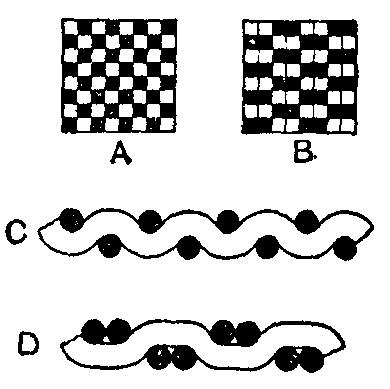
BAGGING, the name given to the textile stuff used for making bags (see also Sacking and Tarpaulin). The material used was originally Baltic hemp, while in the beginning of the 19th century Sunn hemp or India hemp was also employed. Modern requirements call for so many different types of bagging that it is not surprising to find all kinds of fibres used for this purpose. Most bagging is now made from yarns of the jute fibre. The cloth is, in general, woven with the plain weave, and the warp threads run in pairs, but large quantities of bags are made from cloths with single warp threads. In both cases the weave used for the cloth is that shown at A in the figure, but when double threads of warp are used, the arrangement is equivalent to the weave shown at B. The interlacings of the two sets of warp and weft for single and double warp are shown respectively at C and D, the black marks indicating the warp threads, and the white or blanks showing the weft. The particular style of bagging depends, naturally, upon the kind of material it is intended to hold. The coarsest type of bagging is perhaps that known as "cotton bagging," which derives its name from the fact that it is used in the manufacture of bags for transporting raw cotton from the United States of America. It is a heavy fabric 42 in. wide, and weighs from 2 to 2½ lb per yard. A similar, but rather finer make, is used for Sea Island and other fine cotton, and for any species of fibrous material; but for grain, spices, sugar, flour, coffee, manure, &c., the threads of warp and weft must lie closer, and the warp is usually single. For transporting such substances as sugar, it is not uncommon to line the bag with paper, which excludes foreign matter, and minimizes the loss. Although there are large quantities of seamless bags woven in the loom, the greater part of the cloth is woven in the ordinary way. It is then cut up into the required sizes by hand and by special machines, and afterwards sewn by one of the chain-stitch or straight-stitch bag sewing-machines.
BAGHAL, a small native state in the Punjab, India. It is one of the group known as the Simla Hill states, and has an area of 124 sq. m.; pop. (1901) 25,720, showing an increase of 5% in the decade; a revenue £3300.
BAGHERIA, a town of the province of Palermo, Sicily, 8 m. by rail E. by S. of Palermo. Pop. (1901) 18,218. It contains many villas of the aristocracy of Palermo, the majority of which were erected in the 18th century, but have now fallen into decay.
BAGILLT, a town of Flintshire, North Wales, 14½ m. from Chester, on the London & North Western railway, in the ancient parish of Holywell. Pop. (1901) 2637. Its importance is due to its zinc, lead, iron, alkali and kindred works, and its collieries. Above Bagillt is Bryn Dychwelwch, "Hill of Retreat," so called from the retreat effected by Owen Gwynedd, when pursued by Henry II., with superior numbers. Near is Mostyn Hall, dating from the time of Henry VI., the seat of one of the oldest Welsh families. Here are antiquities and MSS. (old British history and Welsh, brought from Gloddaeth), a harp dated 1568, torques (torchau), &c. Henry VII., then earl of Richmond, is said to have been concealed here in the reign of Richard III., when the lord of Mostyn was Richard ap Howel.
BAGIMOND'S ROLL. In 1274 the council of Lyons imposed a tax of a tenth part of all church revenues during the six following years for the relief of the Holy Land. In Scotland Pope Gregory X. entrusted the collection of this tax to Master Boiamund (better known as Bagimund) de Vitia, a canon of Asti, whose roll of valuation formed the basis of ecclesiastical taxation for some centuries. Boiamund proposed to assess the tax, not according to the old conventional valuation but on the true value of the benefices at the time of assessment. The clergy of Scotland objected to this innovation, and, having held a council at Perth in August 1275, prevailed upon Boiamund to return to Rome for the purpose of persuading the pope to accept the older method of taxation. The pope insisted upon the tax being collected according to the true value, and Boiamund returned to Scotland to superintend its collection. A fragment of Bagimond's Roll in something very like its original form is preserved at Durham, and has been printed by James Raine in his Priory of Coldingham (Publications of the Surtees Society, vol. xii.). It gives the real values in one column and tenth parts in another column of each of the benefices in the archdeaconry of Lothian. The actual taxation to which this fragment refers was not the tenth collected by Boiamund but the tenth of all ecclesiastical property in England, Scotland, Wales and Ireland granted by Pope Nicholas IV. to Edward I. of England in the year 1288. The fragment should therefore be regarded as supplementary to the Taxatio Ecclesiastica Angliae et Walliae printed by the Record Commissioners in 1802. Although no contemporary copy of Bagimond's Roll is known to exist, at least three documents give particulars of the taxation of the Church of Scotland in the 16th century, which are based upon the original roll.
See Statuta Ecclesiae Scoticanae (Bannatyne Club, Edinburgh, 1866).
BAGIRMI, a country of north-central Africa, lying S.E. of Lake Chad and forming part of the Chad circumscription of French Congo. It extends some 240 m. north to south and has a breadth of about 150 m., with an area of 20,000 sq. m. The population in 1903 was estimated at 100,000, having been greatly reduced as the result of wars and slave-raiding. By including districts S. and S.E. occupied by former vassal states, the area and population of Bagirmi would be more than doubled. The surface of the country, which lies about 1000 ft. above sea-level, is almost flat with a very slight inclination N. to Lake Chad. It forms part of what seems to be the basin of an immense lake, of which Chad is the remnant. The soil is clay. The river Shari (q.v.) forms the western boundary. Numerous tributaries of the Shari flow through the country, but much of the water is absorbed by swamps and sand-obstructed channels, and seasons of drought are recurrent. The southern part of the country is the most fertile. Among the trees the acacia and the dum-palm are common. Various kinds of rubber vine are found. The fauna includes the elephant, hippopotamus, lion and several species of antelope. Ants are very numerous. Millet and sesame are the principal grains cultivated. Rice grows wild, and several kinds of Poa grass are used as food by the natives. Cotton and indigo are grown to a considerable extent, especially by Bornu immigrants. The capital is Chekna, on a tributary of the Shari, the former capital, Massenia, having been destroyed in 1898. Fort Lamy at the confluence of the Logone and Shari, and Fort de Cointet on the middle Shari, are French posts round which towns have grown. Trade is chiefly with Yola, a town on the Benue in British Nigeria, and with Khartum via Wadai. There is also an ancient caravan route which runs through Kanem and across the Sahara to Tripoli.
The population of Bagirmi is mixed. Negroid peoples predominate, but there are many pastoral Fula and Arabs. The Bagirmese proper are a vigorous, well-formed race of Negroid-Arab blood, who, according to their own traditions, came from the eastward several centuries ago, a tradition borne out by their language, which resembles those spoken on the White Nile. On their arrival they appear to have taken the place of the Bulala dynasty. They subdued the Fula and Arabs already settled in the district, and after being converted to Islam under Abdullah, their fourth king (about 1600), they extended their authority over a large number of tribes living to the south and east. The most important of these tribes are the Saras, Gaberi, Somrai, Gulla, Nduka, Nuba and Sokoro. These pagan tribes were repeatedly raided by the Bagirmese for slaves. Most of them are of a primitive type and appear to be dying out. The Saras are remarkable for their herculean stature, and are one of the most promising of African races. Tree worship is prevalent among the Somrai and the Gaberi. All the tribes believe in a supreme being whose voice is the thunder. Polygamy is general in upper Bagirmi, where some traces of a matriarchal stage of society linger, one small state being called Beled-el-Mra, "Women's Land," because its ruler is always a queen.
Bagirmi was made known to Europe by the travels of Dixon Denham (1823), Heinrich Barth (1852), who was imprisoned by the Bagirmese for some time, Gustav Nachtigal (1872), and P. Matteucci and A. M. Massari (1881). The country in 1871 had been conquered by the sultan of Wadai, and about 1890 was over-run by Rabah Zobeir (q.v.) who subsequently removed farther west to Bornu. About this time French interest in the countries surrounding Lake Chad was aroused. The first expedition led thither through Bagirmi met with disaster, its leader, Paul Crampel, being killed by order of Rabah. Subsequent missions were more fortunate, and in 1897 Emile Gentil, the French commissioner for the district, concluded a treaty with the sultan of Bagirmi, placing his country under French protection. A resident was left at the capital, Massenia, but on Gentil's withdrawal Rabah descended from Bornu and forced sultan and resident to flee. It was not until after the death of Rabah in battle and the rout of his sons (1901) that French authority was firmly established. Kanem, a country north of Bagirmi and subject in turn to it and to Wadai, was at the same time brought under French control. So far as its European rivals are concerned, the French right to these regions is based on the Franco-German convention of the 15th of March 1894 and the Anglo-French declaration of the 21st of March 1899.
See H. Barth, Travels and Discoveries in North and Central Africa (London, 1857-1858); G. Nachtigal, Sahara und Sudan (Berlin, 1879-1889); E. Gentil, La Chute de l'Empire de Rabah (Paris, 1902). Also French Congo.
BAGNACAVALLO, BARTOLOMMEO (1484-1542), Italian painter. His real name was Ramenghi, but he received the cognomen Bagnacavallo from the little village where he was born. He studied first under Francia, and then proceeded to Rome, where he became a pupil of Raphael. While studying under him he worked along with many others at the decoration of the gallery in the Vatican, though it is not known what portions are his work. On his return to Bologna he quickly took the leading place as an artist, and to him were due the great improvements in the general style of what has been called the Bolognese school. His works were considered to be inferior in point of design to some other productions of the school of Raphael, but they were distinguished by rich colouring and graceful delineation. They were highly esteemed by Guido Reni and the Carracci, who studied them carefully and in some points imitated them. The best specimens of Bagnacavallo's works, the "Dispute of St Augustine," and a "Madonna and Child," are at Bologna.
BAGNÈRES-DE-BIGORRE, a town of south-western France, capital of an arrondissement in the department of Hautes-Pyrénées, 13 m. S.S.E. of Tarbes on a branch line of the Southern railway. Pop. (1906) 6661. It is beautifully situated on the left bank of the Adour, at the northern end of the valley of Campan, and the vicinity abounds in picturesque mountain scenery. The town is remarkably neat and clean and many of the houses are built or ornamented with marble. It is one of the principal watering-places in France, and has some fifty mineral springs, characterized chiefly by the presence of sulphate of lime or iron. Their temperature ranges approximately from 59° to 122° Fahr., and they are efficacious in cases of rheumatism, nervous affections, indigestion and other maladies. The season begins in May and terminates about the end of October, during which time the population is more than doubled. The Promenade des Coustous is the centre of the life of Bagnères. Close by stands the church of St Vincent of the 14th and 15th centuries. The old quarter of the town, in which there are several old houses, contains a graceful octagonal tower of the 15th century, the remains of a Jacobin monastery. The Néothermes, occupying part of the casino, and the Thermes (dating from 1824), which has a good library, are the principal bathing-establishments; both are town property. The other chief buildings include the Carmelite church, remains of the old church of St Jean, a museum and the town-hall. Bagnères has tribunals of first instance and of commerce, and a communal college. The manufacture of barège, a light fabric of silk and wool, and the weaving and knitting of woollen goods, wood-turning and the working of marble found in the neighbourhood and imported from elsewhere, are among the industries, and there are also slate quarries. Bagnères was much frequented by the Romans, under whom it was known as Vicus Aquensis, but afterwards lost its renown. It begins to appear again in history in the 12th century when Centulle III., count of Bigorre, granted it a liberal charter. The baths rose into permanent importance in the 16th century, when they were visited by Jeanne d'Albret, mother of Henry IV., and by many other distinguished persons.
BAGNÈRES-DE-LUCHON, a town of south-western France, in the department of Haute-Garonne, 87 m. S.S.W. of Toulouse, on a branch line of the Southern railway from Montréjeau. Pop. (1906) 3448. The town is situated at the foot of the central Pyrenees in a beautiful valley at the confluence of the One and the Pique. It is celebrated for its thermal springs and as a fashionable resort. Of the promenades the finest and most frequented are the Allées d'Etigny, an avenue planted with lime-trees, at the southern extremity of which is the Thermes, or bathing-establishment, one of the most complete in existence. The springs, which number 48, vary in composition, but are chiefly impregnated with sulphate of sodium, and range in temperature from 62° to 150°. A large casino was opened in the town in 1877. The discovery of numerous Roman remains attests the antiquity of the baths, which are identified with the Onesiorum Thermae of Strabo. Their revival in modern times dates from the latter half of the 18th century, and was due to Antoine Mégret d'Etigny, intendant of Auch.
BAGOAS, a Persian name (Bagoi), a shortened form of names like Bagadata, "given by God," often used for eunuchs. The best-known of these ("Bagoses" in Josephus) became the confidential minister of Artaxerxes III. He threw in his lot with the Rhodian condottiere Mentor, and with his help succeeded in subjecting Egypt again to the Persian empire (probably 342 B.C.). Mentor became general of the maritime provinces, suppressed the rebels, and sent Greek mercenaries to the king, while Bagoas administered the upper satrapies and gained such power that he was the real master of the kingdom (Diod. xvi. 50; cf. Didymus, Comm. in Demosth. Phil. vi. 5). He became very wealthy by confiscating the sacred writings of the Egyptian temples and giving them back to the priests for large bribes (Diod. xvi. 51). When the high priest of Jerusalem, Jesus, murdered his brother Johannes in the temple, Bagoas (who had supported Johannes) put a new tax on the Jews and entered the temple, saying that he was purer than the murderer who performed the priestly office (Joseph. Ant. xi. 7.1). In 338 Bagoas killed the king and all his sons but the youngest, Arses (q.v.), whom he raised to the throne; two years later he murdered Arses and made Darius III. king. When Darius attempted to become independent of the powerful vizier (χιλίαρχος), Bagoas tried to poison him too; but Darius was warned and forced him to drink the poison himself (Diod. xvii. 5; Johann. Antioch, p. 38, 39 ed. Müller; Arrian ii. 14. 5; Curt. vi. 4. 10). A later story, that Bagoas was an Egyptian and killed Artaxerxes III. because he had killed the sacred Apis (Aelian, Var. Hist. vi. 8), is without historical value. Bagoas' house in Susa, with rich treasures, was presented by Alexander to Parmenio (Plut. Alex. 39); his gardens in Babylon, with the best species of palms, are mentioned by Theophrastus (Hist. Plant, ii. 6; Plin. Nat. Hist. xiii. 41). Another eunuch, Bagoas, was a favourite of Alexander the Great (Dicaearchus in Athen. xiii. 603b; Plut. Al. 67; Aelian, Var. Hist. 3. 23; Curt. vi. 5. 23; x. 1. 25 ff.).
(Ed. M.)
BAG-PIPE (Celt. piob-mala, ullan-piob, cuislean, cuislin; Fr. cornemuse, chalemie, musette, sourdeline, chevrette, loure; Ger. Sackpfeife, Dudelsack; M. H. Ger. Suegdbalch[1]; Ital. cornamusa, piva, sampogna, surdelina; Gr. ἄσκαυλος (?); Lat. ascaulus (?), tibia utricularis, utricularium; med. Lat. chorus), a complex reed instrument of great antiquity. The bag-pipe forms the link between the syrinx (q.v.) and the primitive organ, by furnishing the principle of the reservoir for the wind-supply, combined with a simple method of regulating the sound-producing pressure by means of the arm of the performer. The bag-pipes consists of an air-tight leather bag having three to five apertures, each of which contains a fixed stock or short tube. The stocks act as sockets for the reception of the pipes, and as air-chambers for the accommodation and protection of the reeds. The pipes are of three kinds: (1) a simple valved insufflation tube or "blow-pipe," by means of which the performer fills the bag reservoir; (2) the "chaunter" (chanter) or the melody-pipe, having according to the variety of the bag-pipe a conical or a cylindrical bore, lateral holes, and in some cases keys and a bell; the "chaunter" is invariably made to speak by means of a double-reed; (3) the "drones," jointed pipes with cylindrical bore, generally terminating in a bell, but having no lateral holes and being capable, therefore, of producing but one fixed note.
The main characteristic of the bag-pipe is the drone ground bass which sounds without intermission. Each drone is fitted with a beating-reed resembling the primitive "squeaker" known to all country lads; it is prepared by making a cut partly across a piece of cane or reed, near the open end, and splitting back from this towards a joint or knot, thus raising a tongue or flap. The beating-reed is then fixed in a socket of the drone, which fits into the stock. The sound is produced by the stream of air forced from the bag into the drone-pipe by the pressure of the performer's arm, causing the tongue of reed to vibrate over the aperture, thus setting the whole column of air in vibration. The drone-pipe, like all cylindrical tubes with reed mouthpieces, has the acoustic properties of the closed pipe and produces the note of a pipe twice its length. The drones are tuned by means of sliding-joints.
The blow-pipe and the chaunter occupy positions at opposite extremities of the bag, which rests under the arm of the performer while the drones point over his shoulder. These are the main features in the construction of the bag-pipe, whose numerous varieties fall into two classes according to the method of inflating the bag: (1) by means of the blow-pipe described above; (2) by means of a small bellows connected by a valved feed-pipe with the bag and worked by the other arm or elbow to which it is attached by a ribbon or strap.
Class I. comprises: (a) the Highland bag-pipe; (b) the old Irish bag-pipe; (c) the cornemuse; (d) the bignou or biniou (Breton bag-pipe); (e) the Calabrian bag-pipe; (f) the ascaulus of the Greeks and Romans; (g) the tibia utricularis; (h) the chorus. To Class II. belong: (a) the musette; (b) the Northumbrian or border bag-pipe; (c) the Lowland bag-pipe; (d) the union pipes of Ireland; (e) the surdelina of Naples.
1. The Highland Bag-pipe.—The construction of the Highland pipes is practically that given above. The chaunter consists of a conical wooden tube terminating in a bell and measuring from 14 to 16 in. including the reed. There are seven holes in front and one at the back for the thumb of the left hand, which fingers the upper holes while the right thumb merely supports the instrument. The holes are stopped by the under part of the joints of the fingers. There is in addition a double hole near the bell, which is never covered, and merely serves to regulate the pitch. As the double reed is not manipulated by the lips of the performer, only nine notes are obtained from the chaunter, as shown:—[2][3]

The notes do not form any known diatonic scale, for in addition to the C and F being too sharp, the notes are not strictly in tune with each other. Donald MacDonald, in his treatise on the bag-pipe[4] states that "the piper is to pay no attention to the flats and sharps marked on the clef, as they are not used in pipe music; yet the pipe imitates several different keys which are real, but ideal on the bag-pipe, as the music cannot be transposed for it into any other key than that in which it is first played or marked." Mr Glen, the great dealer in bag-pipes, gave it as his opinion "that if the chaunter were to be made perfect in any one scale, it would not go well with the drones. Also, there would not be nearly so much music produced (if you take into consideration that it has only nine invariable notes) as at present it adapts itself to the keys of A maj., D maj., B min., G maj., E min. and A min. Of course we do not mean that it has all the intervals necessary to form scales in all those keys, but that we find it playing tunes that are in one or other of them."[5] Mr Ellis considers that the natural scale of the chaunter of the bag-pipe corresponds most nearly with the Arab scale of Zalzal, a celebrated lutist who died c. A.D. 800.
The three drones are usually tuned to A, the two smallest one octave below the A of the chaunter, and the largest two octaves below. The three principal methods of tuning the drones are shown as follows:—[6][7]
The excessive use of ornamental notes on the Highland bag-pipe has arisen from a technical peculiarity of the instrument, which makes a repetition of the same note difficult without the interpolation of what is known among pipers as "cuts" or "warblers," i.e. grace notes fingered with great rapidity (see below for an example). These warblers, which consist not only of single notes but of groups of from three to seven notes, not consecutive but in leaps, assist in relieving the constant discord with the drone bass. Skilful pipers have been known to introduce warblers of as many as eleven notes between two beats in a bar.

The use of musical notation for the Highland pipe tunes is a recent innovation; the pipers used verbal equivalents for the notes; for instance, the piobaireachd Coghiegh nha Shie, "War of peace,"[8] which opens as shown here, was taken down by Capt. Niel MacLeod from the piper John McCrummen of Skye as verbally taught to apprentices as follows:—
"Hodroho, hodroho, haninin, hiechin, Hodroha, hodroho, hodroho, hachin, Hiodroho, hodroho, haninin, hiechin," &c.
The conclusion of the tune is thus expressed:
"Hiundratatateriri, hiendatatateriri, hiundratatateriri, hiundratatateriri."[9]
Written down this seems a mere unintelligible jumble, but could we hear it, as sounded by the pipers, with due regard for the rhythmical value of notes, it would be a very different matter. Alexander Campbell[10] relates that a melody had to be taken down or translated "from the syllabic jargon of illiterate pipers into musical characters, which, when correctly done, he found to his astonishment to coincide exactly with musical notation."
Fig. 1.—(1) Cornemuse. (2) Irish bag-pipe. (3) Musette. (4) Highland bag-pipe, A.D. 1409. (5) Border bag-pipe.
(From Capt. C. R. Day's Descriptive Catalogue of Musical Instruments exhibited at the Royal Military Exhibition, by permission of Eyre & Spottiswoode.)
A Highland bag-pipe of the 15th century, dated MCCCCIX., in the possession of Messrs J. & R. Glen of Edinburgh, was exhibited at the Royal Military Exhibition in London in 1890[11] (see fig. 1 (4)). There were two drones, inserted in a single stock in the form of a wide-spread fork, and tuned to A in unison with the lowest note of the chaunter, which had seven finger-holes in front and a thumb-hole at the back.