RUINS IN VERDE VALLEY
Reading edition
Classification of the Ruins
The ruined habitations in the valley of the Rio Verde may be considered under three divisions or types, differing in form, but essentially the same in character. In adopting this classification, which is by no means restricted to this single valley, I do not claim originality, but follow that used by the best writers on this subject. My limitation of the types and general definitions may, however, be found to differ somewhat from those of my predecessors.
The three groups of ruins in our Southwest are the following:
I—Pueblos, or Independent habitations. II—Cliff Houses } III—Cavate Dwellings } Dependent habitations.
In the first group are placed those ancient or modern habitations which are isolated, on all sides, from cliffs. They may be situated in valleys or on elevations or mesas; they may be constructed of clay, adobe, or stone of various kinds, but are always isolated from cliffs. They are single or multiple chambered, circular or rectangular in shape, and may have been built either as permanent habitations or as temporary outlooks. Their main feature is freedom, on all sides except the foundation, from cliffs or walls of rock in place.
The second group includes those not isolated from natural cliffs, but with some part of their lateral walls formed by natural rock in situ, and are built ordinarily in caverns with overhanging roofs, which the highest courses of their walls do not join. Generally erected in caves, their front walls never close the entrances to those caverns. This kind of aboriginal buildings may, like the former, vary in structural material; but, so far as I know, they are not, for obvious reasons, made of adobe alone.
The third kind of pueblo dwellings are called cavate dwellings or lodges, a group which includes that peculiar kind of aboriginal dwelling where the rooms are excavated from the cliff wall, forming caves, where natural rock is a support or more often serves as the wall itself of the dwelling. The entrance may be partially closed by masonry, the floor laid with flat stones, and the sides plastered with clay; but never in this group is there a roof distinct from the top of the cave.
Naturally cavate dwellings grade into cliff houses, but neither of these types can be confounded with the first group, which affords us no difficulty in identification. All these kinds of dwellings were made by people of the same culture, the character of the habitation depending on geological environment.
BUREAU OF AMERICAN ETHNOLOGY—— SEVENTEENTH ANNUAL REPORT PL. XCIa CAVATE DWELLINGS—RIO VERDE
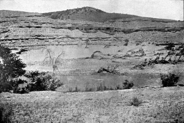
In Verde valley, villages, cliff houses, and cavate dwellings exist together, and were, I believe, contemporaneously inhabited by a people of the same culture.
These types of ancient habitations are not believed to stand in the relationship of sequence in development; nor is one simpler or less difficult of construction than the others. Cliff houses display no less skill and daring than do the villages in the plain, called pueblos. The cavate dwellings are likewise a form of habitation which shows considerable workmanship, and are far from caves like those inhabited by "cave men." These dwellings were laboriously excavated with rude implements; had floors, banquettes, windows, walled recesses, and the like. It is hardly proper to regard them, as less difficult to construct than pueblos or cliff houses.
Cavate dwellings, like villages or cliff houses, may be single or multiple, single or many chambered, and a cluster of these troglodytic dwellings was, in fact, as truly a village as a pueblo or cliff house. The same principle of seeking safety by crowding together held in all three instances; and this very naturally, for the culture of the inhabitants was identical. I shall consider only two of the three types of dwellings in Verde valley, namely, the second and third groups.
It has, I think, been conclusively shown by Mr Cosmos Mindeleff, so far as types of the first group of ruins on the Verde are concerned, that they practically do not differ from the modern Tusayan pueblos. The remaining types, when rightly interpreted, furnish evidence of no less important character. Notwithstanding Mindeleff's excellent descriptions of the cavate dwellings of this region, already cited, I have thought it well to bring into prominence certain features which seem to me to indicate that this form of aboriginal dwelling was high in its development, showing considerable skill in its construction, and was fashioned on the same general plan as the others. For this demonstration I have chosen one of the most striking clusters in Verde valley.
Cavate Dwellings
The most accessible cavate dwellings in Verde valley (plate xci a) are situated on the left bank of the river, about eight miles southward from Camp Verde and three miles from the mouth of Clear creek. The general characteristics of this group have been well described by Mr Mindeleff in the Thirteenth Annual Report of the Bureau, so that I need but refer to a few additional observations made on these interesting habitations.[14]
These cavate lodges afford a fair idea of the best known of these prehistoric dwellings in this part of Arizona. Although Verde valley has many fine ranches, the land in immediate proximity to these ruins is uncultivated. The nearest habitation, however, is not far away, and it is not difficult to find guides to these caves, so well known are they to the inhabitants of this part of the valley. It did not take long to learn that any investigations which I might attempt there had been anticipated by other archeologists and laymen, for many of the rooms had been rifled of their contents and their walls thrown down, while it was also evident that some careful excavations had been made.
There is, however, abundant opportunity for more detailed scientific work than has yet been attempted on these ruins, and what has thus far been accomplished has been more in the nature of reconnoissance. The cemeteries and burial places of the prehistoric people of the cavate dwellings are yet to be discovered, and it is probable, judging from experience gained at other ruins, that when they are found and carefully investigated much light will be thrown on the character of ancient cave life.
The entrances to the cavate dwellings opposite Squaw mountain are visible from the road for quite a distance, appearing as rows of holes in the steep walls of the cliff on the opposite or left bank of the Rio Verde. Owing to their proximity to the river, from which the precipice in which they are situated rises almost vertically, we were unable to camp under them, but remained on the right bank of the river, where a level plain extends for some distance, bordering the river and stretching back to the distant cliffs. We pitched our camp on a bluff, about 30 feet above the river, in full sight of the cave entrances, near a small stone inclosure which bears quite a close resemblance to a Tusayan shrine.
Aboriginal people had evidently cultivated the plain where we camped, for there are many evidences of irrigating ditches and even walls of former houses. At present, however, this once highly cultivated field lies unused, and is destitute of any valuable plants save the scanty grass which served to eke out the fodder of our horses.
At the time of my visit the water of Rio Verde at this point was confined to a very narrow channel under the bluff near its right bank, but the appearance of its bed showed that in heavy freshets during the rainy season the water filled the interval between the base of the cliffs in which the cavate dwellings are situated and the bluffs which form the right bank.
In visits to the caves it was necessary, on account of the site of the camp, to ford the stream each time and to climb to their level over fallen stones, a task of no slight difficulty. The water in places was shallow and the current only moderately rapid. Considering the fact that it furnished potable liquid for ourselves and horses, and that the line of trees which skirted the bluff was available for firewood, our camp compared well with many which we subsequently made in our summer's explorations.
BUREAU OF AMERICAN ETHNOLOGY—— SEVENTEENTH ANNUAL REPORT PL. XCIb CAVATE DWELLINGS—OAK CREEK
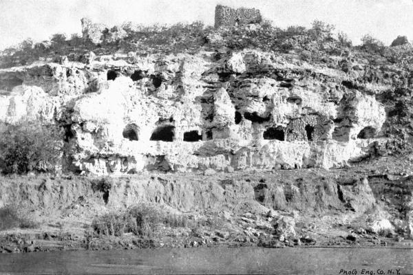
The section of the cliff which was examined embraced the northern series of these caves, extending from a promontory forming one side of a blind or box canyon to nearly opposite our camp. Adjacent to this series of rooms, but farther down the river, on the same side, there are two narrow side canyons, in both of which are also numerous caves, in all respects similar to the series we chose for examination. At several points on the summit of the cliffs, above the caves, large rectangular ruins, with fallen walls, were discovered; these ruins are, however, in no respect peculiar, but closely resemble those ordinarily found in a similar position throughout this region and elsewhere in Arizona and New Mexico. From their proximity to the caves it would seem that the cavate dwellings, and the pueblos on the summits of the mesas in which they are found, had been inhabited by one people; but better evidence that such is true is drawn from the character of the architecture and the nature of the art remains common to both.
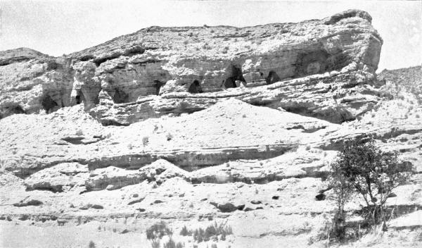
Let us first consider the series of caves from a point opposite our camp to the promontory which forms a pinnacle at the mouth of the first of the two side caverns—a row of caves the entrances to which are shown in the accompanying illustration (plate xcii). I have lettered these rooms, as indicated by their entrances, a to l, beginning with the opening on the left.
The rock in which these caves have been hewn is very soft, and almost white in color, save for a slightly reddish brown stratum just below the line of entrances to the cavate chambers. Although, as a general thing, the wall of the cliff is almost perpendicular, and the caves at points inaccessible, entrance to the majority of them can be effected by mounting the heaps of small stones forming the débris, which has fallen even to the bed of the river at various places, and by following a ledge which connects the line of entrances. The easiest approach mounts a steep decline, not far from the promontory at the lower level of the line, which conducts to a ledge running along in front of the caves about 150 feet above the bed of the stream. Roughly speaking, this ledge is about 100 feet below the summit of the cliff. It was impossible to reach several of the rooms, and it is probable that when the caves were inhabited access to any one of them was even more difficult than at present.
Judging from the number of rooms, the cliffs on the left bank of the Verde must have had a considerable population when inhabited. These caverns, no doubt, swarmed with human beings, and their inaccessible position furnished the inhabitants with a safe refuge from enemies, or an advantageous outlook or observation shelter for their fields on the opposite side of the stream. The soft rock of which the mesa is formed is easily worked, and there are abundant evidences, from the marks of tools employed, that the greater part of each cave was pecked out by hand. Fragments of wood were very rarely seen in these cliff dugouts; and although there is much adobe plastering, only in a few instances were the mouths of the caves walled or a doorway of usual shape present. The last room at the southern end, near the promontory at the right of the entrance to a side canyon, has walls in front resembling those of true cliff houses and pueblos in the Red-rock country farther northward, as will be shown in subsequent pages.
This group of cavate dwellings, while a good example of the cavern type of ruins, is so closely associated, both in geographical position and in archeological remains, with other types in Verde valley, that we are justified in referring them to one and the same people. The number of these troglodytic dwelling places on the Verde is very large; indeed the mesas may be said to be fairly honeycombed with subterranean habitations. Confined as a general thing to the softer strata of rock, which from its character was readily excavated, they lie side by side at the same general level, and are entered from a projecting ledge, formed by the top of the talus which follows the level of their entrances.
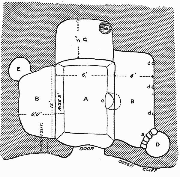
Fig. 245—Plan of cavate dwelling on Rio Verde
This ledge is easily accessible in certain places from the river bed, where stones have fallen to the base of the cliff; but at most points no approach is possible, and in their impregnable position the inhabitants could easily defend themselves from hostile peoples.
BUREAU OF AMERICAN ETHNOLOGY—— SEVENTEENTH ANNUAL REPORT PL. XCII ENTRANCES TO CAVATE RUINS
Whether the rock had recesses in it before the caves were enlarged would seem to be answered in the affirmative, for similar caves without evidences of habitations were observed. These, however, are as a rule small, and wherever available the larger caverns have been appropriated and enlarged by stone implements, as shown by the pecking on the walls. The enlargement of these caverns, however, would not be a difficult task, for the rock is very soft and easily worked.
Entering one of these cavate rooms the visitor finds himself in a dark chamber, as a rule with side openings or passageways into adjoining rooms. Broad lateral banquettes are prominent features in the most complicated caves, and there are many recesses and small closets or cists.
The ramifications formed by lateral rooms are often extensive, and the chambers communicate with others so dark that we can hardly regard them as once inhabited. In these dimly lighted rooms the walls were blackened with smoke, as if from former fires, and in many of the largest the position of fireplaces could plainly be discovered. As a type of one of the more complicated I have chosen that figured to illustrate the arrangement of these cavate dwellings (figure 245). Many are smaller, others have more lateral chambers, but one type is characteristic of all.
A main room (a, figure 245), or that first entered from outside, is roughly rectangular in shape, 12 feet long by 6 feet wide, and about 6 feet high. The floor, however, was covered with very dry débris which had blown in from the exterior or, in some instances, fallen from the roof. That part of the floor which was exposed shows that it was roughly plastered, sometimes paved or formed of solid rock.
On three sides of this room there is a step 2 feet high, to platforms, three in number, one in the rear and one on each side. These platforms are 5, 6, and 6 feet 6 inches wide, respectively, and of the same length as the corresponding sides of the central room. It would appear that these platforms are characteristic architectural features of these habitations, and we find them reproduced in some of the rooms of the cliff houses of the Red-rocks, while Nordenskiöld has described a kindred feature in the kivas of the Mesa Verde ruins. A somewhat similar elevation of the floor in modern Tusayan kivas forms what may be called the spectator's part, in front of the ladder as one descends, and the same feature is common to many older Hopi dwellings.[15]
Beginning with the lateral platforms (b, figure 245) we first note, as we step upon it at c, about midway of its length, a small circular depression in the floor of the central room extending slightly beneath the platform, as indicated by the dotted line. It is possible that this niche was a receptacle for important household objects, although it may have been a fireplace.
In a corner of the right platform a round cist, partially hewn out of the rock, was found, but its walls (a, figure 245) were badly broken down by some former explorer. The floor of this recess lies below that of the platform, while the cist itself (d) reminds one of the closed or walled structures, so commonly found in the Verde, attached to the side of the cliff. On the lateral wall of this chamber, at about the height of the head, a row of small holes had been drilled into the solid wall. These holes (d, d, d) are almost too small for the insertion of roof beams, and were probably made for pegs on which to rest a beam for hanging blankets and other textile fabrics when not in use. The roof of the cave was the natural rock, and showed over its whole surface marks of a pecking implement.
The left chamber is 6 feet 6 inches broad, and from one corner, opposite the doorway, a low passageway leads into a circular chamber, 6 feet in diameter, with its floor below the platform of the lateral room. Between the chamber, on the left of the entrance, and the open air, the wall of solid rock is broken by a slit-like crevice, which allows the light to enter, and no doubt served as a window. A recess, the floor of which is elevated, on a platform opposite the doorway, is 5 feet broad, and has a small circular depression in one corner. The floor and upraise of this recess is plastered with adobe, which in several places is smooth and well made.
In comparing the remaining cavate dwellings of this series with that described, we find every degree of complication in the arrangement of rooms, from a simple cave, or irregular hole in the side of the cliff, to squared chambers with lateral rooms. The room I,[16] for instance, is rectangular, 6 feet long by 3 feet wide, with an entrance the same width as that of the room itself.
In room III, however, the external opening is very small, and there is a low, narrow ledge, or platform, opposite the doorway. There is likewise in this room a small shelf in the left-hand wall. In IV there is a raised platform on two adjacent sides of the square room, and the doorway is an irregular orifice broken through the wall to the open air.
Room IV is a subterranean chamber, most of the floor of which is littered with large fragments of rock which have fallen from the roof. It has numerous small recesses in the wall resembling cubby-holes where household utensils of various kinds were undoubtedly formerly kept. This room is instructive, in that the entrance is partially closed by two walls of masonry, which do not join. The stones are laid in adobe in which fragments of pottery were detected. These unjoined walls leave a doorway which is thus flanked on each side by stone masonry, recalling in every particular the well-known walls of cliff houses. Here, in fact, we have so close a resemblance to the masonry of true cliff houses that we can hardly doubt that the excavators of the cavate dwellings were, in reality, people similar to those who built the cliff houses of Verde valley.
Room VIII is a simple cave hewn out of the rock, with a chamber behind it, entered by a passageway made of masonry, which partially fills a larger opening. The doorway through this masonry is small below, but broadens above in much the same manner as some of the doorways in Tusayan of today.
Continuing along the left bank of the river, from the row of cavate rooms, just described, on the first mesa, we round a promontory and enter a small canyon,[17] which is perforated on each side with numerous other cavate dwellings, large and small, all of the same general character as the type described. Here, likewise, are small external openings which evidently communicated with subterranean chambers, but many of them are so elevated that access to them from the floor of the canyon or from the cliff above is not possible. A marked feature of the whole series is the existence here and there of small, often inaccessible, stone cists of masonry plastered to the side of the rocky cliff like swallows' nests.
All of these cists which are accessible had been opened and plundered before my visit, but there yet remain a few which are still intact and would repay examination and study. Similar walled-up cists are likewise found, as we shall see later, in the cliff-houses of the Red-rock country, hence are not confined to the Verde system of ruins.
Cavate dwellings similar to those here described are reported to exist in the canyons of upper Salado, Gala, and Zuñi rivers, and we may with reason suspect that the distribution[18] of cavate dwellings is as wide as that of the pueblos themselves, the sole requisite being a soft tufaceous rock, capable of being easily worked by people with stone implements. In none of the different regions in which they exist is there any probability that these caves were made by people different in culture from pueblo or cliff dwellers. They are much more likely to have been permanent than temporary habitations of the same culture stock of Indians who availed themselves of rock shelters wherever the nature of the cliff permitted excavation in its walls.
That the cavate lodges are simple "horticultural outlooks" is an important suggestion, but one might question whether they were conveniently placed for that purpose. So far as overlooking the opposite plain (which had undoubtedly been cultivated in ancient times) is concerned, the position of some of them may be regarded good for that purpose, but certainly not so commanding as that of the hill or mesa above, where well-marked ruins still exist.
The position of the cavate dwellings is a disadvantageous one to reach any cultivated fields if defenders were necessary. When the Tusayan Indian today moves to his kisi or summer brush house shelter he practically camps in his corn or near it, in easy reach to drive away crows, or build wind-breaks to shelter the tender sprouts; but to go to their cornfields the inhabitants of the cavate dwellings I have described were forced to cross a river before the farm was reached. That these cavate dwellings were lookouts none can deny, but I incline to a belief that this does not tell the whole story if we limit them to such use. It is not wholly clear to me that they were not likewise an asylum for refuge, possibly not inhabited continuously, but a very welcome retreat when the agriculturist was sorely pressed by enemies. Following the analogy of a Hopi custom of building temporary booths near their fields, may we not suppose that the former inhabitants of Verde valley may have erected similar shelters in their cornfields during summer months, retiring to the cavate dwellings and the mesa tops in winter? All available evidence would indicate that the cavate dwellings were permanent habitations.[19]
There are several square ruins on top of the mesa above the cavate dwellings. The walls of these were massive, but they are now very much broken down, and the adobe plastering is so eroded from the masonry that I regard them of considerable antiquity. They do not differ from other similar ruins, so common elsewhere in New Mexico and Arizona, and are identical with others in the Verde region. I visited several of these ruins, but made no excavations in them, nor added any new data to our knowledge of this type of aboriginal buildings. The pottery picked up on the surface resembles that of the ruins of the Little Colorado and Gila.
The dwellings which I have mentioned above are said[20] to be duplicated at many other points in the watershed of the Verde, and many undescribed ruins of this nature were reported to me by ranchmen. I do not regard them as older than the adjacent ruins on the mesa above or the plains below them, much less as productions of people of different stages of culture, for everything about them suggests contemporaneous occupancy.
From what little I saw of the village sites on the Verde I believe that Mindeleff is correct in considering that these ruins represent a comparatively late period of pueblo architecture. The character of the cliff houses of the Red-rocks shows no very great antiquity of occupancy. While it is not possible to give any approximate date when they were inhabited, their general appearance indicates that they are not more than two centuries old. There is, however, no reference to them in the early Spanish history of the Southwest.
BUREAU OF AMERICAN ETHNOLOGY—— SEVENTEENTH ANNUAL REPORT PL. XCIII BOWLDER WITH PICTOGRAPHS NEAR WOOD'S RANCH
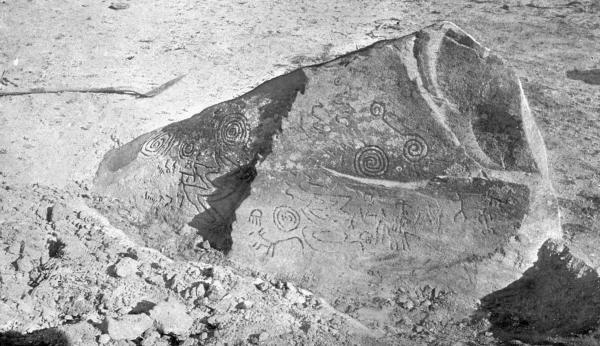
Few pictographs were found in the immediate neighborhood of the cavate dwellings; indeed the rock in their vicinity is too soft to preserve for any considerable time any great number of these rock etchings. Examples of ancient paleography were, however, discovered a short distance higher up the river on malpais rock, which is harder and less rapidly eroded. A half-buried bowlder (plate xciii) near Wood's ranch was found to be covered with the well-known spirals with zigzag attachments, horned animals resembling antelopes, growing corn, rain clouds, and similar figures. These pictographs occur on a black, superficial layer of lava rock, or upon lighter stone with a malpais layer, which had been pecked through, showing a lighter color beneath. There is little doubt that many examples of aboriginal pictography exist in this neighborhood, which would reward exploration with interesting data. The Verde pictographs can not be distinguished, so far as designs are concerned, from many found elsewhere in Colorado, Utah, New Mexico, and Arizona.
An instructive pictograph, different from any which I have elsewhere seen, was discovered on the upturned side of a bowlder not far from Hance's ranch, near the road from Camp Verde to the cavate dwellings. The bowlder upon which they occur lies on top of a low hill, to the left of the road, near the river. It consists of a rectangular network of lines, with attached key extensions, crooks, and triangles, all pecked in the surface. This dædalus of lines arises from grooves, which originate in two small, rounded depressions in the rock, near which is depicted the figure of a mountain lion. The whole pictograph is 3-1/2 feet square, and legible in all its parts.
The intent of the ancient scribe is not wholly clear, but it has been suggested that he sought to represent the nexus of irrigating ditches in the plain below. It might have been intended as a chart of the neighboring fields of corn, and it is highly suggestive, if we adopt either of these explanations or interpretations, that a figure of the mountain lion is found near the depressions, which may provisionally be regarded as representing ancient reservoirs. Among the Tusayan Indians the mountain lion is looked on as a guardian of cultivated fields, which he is said to protect, and his stone image is sometimes placed there for the same purpose.
In the vicinity of the pictograph last described other bowlders, of which there are many, were found to be covered with smaller rock etchings in no respect characteristic, and there is a remnant of an ancient shrine a few yards away from the bowlder upon which they occur.
Montezuma Well
One of the most interesting sites of ancient habitation in Verde valley is known as Montezuma Well, and it is remarkable how little attention has been paid to it by archeologists.[21] Dr Mearns, in his article on the ancient dwellings of Verde valley, does not mention the well, and Mindeleff simply refers to the brief description by Dr Hoffman in 1877. These ruins are worthy of more study than I was able to give them, for like many other travelers I remained but a short time in the neighborhood. It is possible, however, that some of my hurried observations at this point may be worthy of record.
Montezuma Well (plate xciv) is an irregular, circular depression, closely resembling a volcanic crater, but evidently, as Dr Hoffman well points out, due to erosion rather than to volcanic agencies. As one approaches it from a neighboring ranch the road ascends a low elevation, and when on top the visitor finds that the crater occupies the whole interior of the hill. The exact dimensions I did not accurately determine, but the longest diameter of the excavation is estimated at about 400 feet; its depth possibly 70 feet. On the eastern side this depression is separated from Beaver creek by a precipitous wall which can not be scaled from that side. At the time of my visit there was considerable water in the "well," which was reported to be very deep, but did not cover the whole bottom. It is possible to descend to the water at one point on the eastern side, where a trail leads to the water's edge.
There appears to be a subterranean waterway under the eastern rim of the well, and the water from the spring rushes through this passage into Beaver creek. At the time of my visit this outflow was very considerable, and in the rainy season it must be much greater. The well is never dry, and is supplied by perennial subterranean springs rather than by surface drainage.
The geological agency which has been potent in giving the remarkable crater-like form to Montezuma Well was correctly recognized by Dr Hoffman[22] and others as the solvent or erosive power of the spring. There is no evidence of volcanic formation in the neighborhood, and the surrounding rocks are limestones and sandstones. Not far from Navaho springs there is a similar circular depression, called Jacob's Well, but which was dry when visited by me. This may later be found to have been formed in a similar way. At several places in Arizona there are formations of like geological character.
BUREAU OF AMERICAN ETHNOLOGY—— SEVENTEENTH ANNUAL REPORT PL. XCIV MONTEZUMA WELL
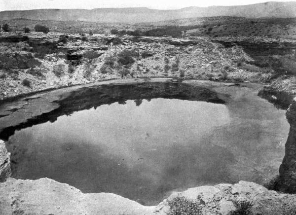
The walls of Montezuma Well are so nearly perpendicular that descent to the edge of the water is difficult save by a single trail which follows the detritus to a cave on one side. In this cave, the roof of which is not much higher than the water level, there are fragments of masonry, as if structures of some kind had formerly been erected in it. I have regarded this cave rather as a place of religious rites than of former habitation, possibly a place of retreat for ancient priests when praying for rain or moisture, or a shrine for the deposit of prayer offerings to rain or water gods.
Several isolated cliff dwellings are built at different levels in the sides of the cliffs. One of the best of these is diametrically opposite the cave mentioned above, a few feet below the rim of the depression. While this house was entered with little difficulty, there were others which I did not venture to visit.
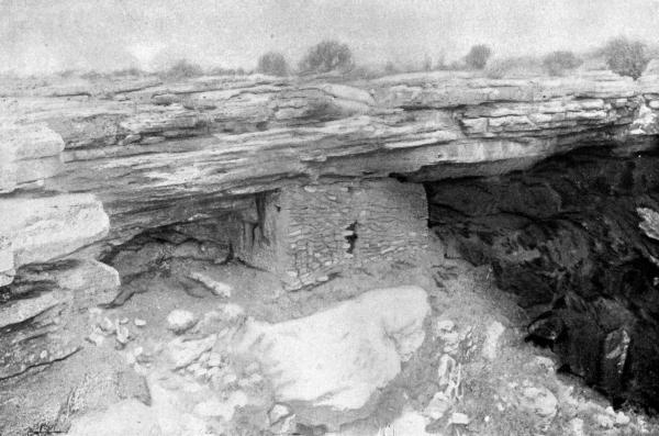
The accompanying illustration (plate xcv) gives an idea of the general appearance of one of these cliff houses of Montezuma Well. It is built under an overhanging archway of rock in a deep recess, with masonry on three sides. The openings are shown, one of which overlooks the spring; the other is an entrance at one side. The face of masonry on the front is not plastered, and if it was formerly rough cast the mud has been worn away, leaving the stones exposed. The side wall, which has been less exposed to the elements, still retains the plastering, which is likewise found on the inner walls where it is quite smooth in places.
The number of cliff rooms in the walls of the well is small and their capacity, if used as dwellings, very limited. There are, however, ruins of pueblos of some size on the edge of the well.
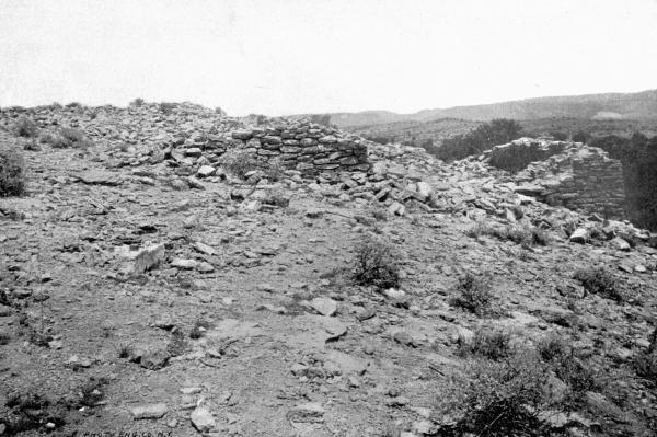
One of the largest of these, shown in the accompanying illustration (plate xcvi), is situated on the neck of land separating the well from the valley of Beaver creek. This pueblo was rectangular in form, of considerable size, built of stones, and although at present almost demolished, shows perfectly the walls of former rooms. Fragments of ancient pottery would seem to indicate that the people who once inhabited this pueblo were in no respect different from other sedentary occupants of Verde valley. From their housetops they had a wide view over the creek on one side and the spring on the other, defending, by the site of their village, the one trail by which descent to the well was possible.
The remarkable geological character of Montezuma Well, and the spring within it, would have profoundly impressed itself on the folklore of any people of agricultural bent who lived in its neighborhood after emigrating to more arid lands. About a month after my visit to this remarkable spring I described the place to some of the old priests at Walpi and showed them sketches of the ruins. These priests seemed to have legendary knowledge of a place somewhat like it where they said the Great Plumed Snake had one of his numerous houses. They reminded me of a legend they had formerly related to me of how the Snake arose from a great cavity or depression in the ground, and how, they had heard, water boiled out of that hole into a neighboring river. The Hopi have personal knowledge of Montezuma Well, for many of their number have visited Verde valley, and they claim the ruins there as the homes of their ancestors. It would not be strange, therefore, if this marvelous crater was regarded by them as a house of Palülükoñ, their mythic Plumed Serpent.
Practically little is known of the pictography of this part of the Verde valley people, although it has an important bearing on the distribution of the cliff dwellers of the Southwest. There is evidence of at least two kinds of petroglyphs, indicative of two distinct peoples. One of these was of the Apache Mohave; the other, the agriculturists who built the cliff homes and villages of the plain. Those of the latter are almost identical with the work of the Pueblo peoples in the cliff dweller stage, from southern Utah and Colorado to the Mexican boundary. It is not a difficult task to distinguish the pictography of these two peoples, wherever found. The pictographs of the latter are generally pecked into the rock with a sharpened implement, probably of stone, while those of the former are usually scratched or painted on the surface of the rocks. Their main differences, however, are found in the character of the designs and the objects represented. This difference can be described only by considering individual rock drawings, but the practiced eye may readily distinguish the two kinds at a glance. The pictographs which are pecked in the cliff are, as a rule, older than those which are drawn or scratched, and resemble more closely those widely spread in the Pueblo area, for if the cliff-house people ever made painted pictographs, as there is every reason to believe they did, time has long ago obliterated them.
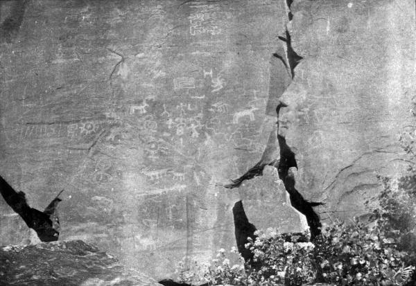
The pictured rocks (plate xcvii) near Cliff's ranch, on Beaver creek, four miles from Montezuma Well, have a great variety of objects depicted upon them. These rocks, which rise from the left bank of the creek opposite Cliff's ranch, bear over a hundred different rock pictures, figures of which are seen in the accompanying illustration. The rock surface is a layer of black malpais, through which the totem signatures have been pecked, showing the light stone beneath, and thus rendering them very conspicuous. Among these pictographs many familiar forms are recognizable, among them being the crane or blue heron, bears' and badgers' paws, turtles, snakes, antelopes, earth symbols, spirals, and meanders.
Among these many totems there was an unusual pictograph in the form of the figure 8, above which was a bear's paw accompanied by a human figure so common in southwestern rock etchings. A square figure with interior parallel squares extending to the center is also found, as elsewhere, in cliff-dweller pictography.
BUREAU OF AMERICAN ETHNOLOGY—— SEVENTEENTH ANNUAL REPORT PL. XCV CLIFF HOUSE, MONTEZUMA WELL
Cliff Houses of the Red-Rocks
After the road from old Camp Verde to Flagstaff passes a deserted cabin at Beaver Head, it winds up a steep hill of lava or malpais to the top of the Mogollones. If, instead of ascending this hill, one turns to the left, taking an obscure road across the river bed, which is full of rough lava blocks, and in June, when I traveled its course, was without water, he soon finds himself penetrating a rugged country with bright-red cliffs on his right (plate xcviii). Continuing through great parks and plains he finally descends to the well-wooded valley of Oak creek, an affluent of Rio Verde. Here he finds evidences of aboriginal occupancy on all sides—ruins of buildings, fortified hilltops, pictographs, and irrigating ditches—testifying that there was at one time a considerable population in this valley. The fields of the ancient inhabitants have now given place to many excellent ranches, one of the most flourishing of which is not far from a lofty butte of red rock called the Court-house, which from its great size is a conspicuous object for miles around. In many of these canyons there are evidences of a former population, but the country is as yet almost unexplored; there are many difficult places to pass, yet once near the base of the rocks a way can be picked from the mouth of one canyon to another. It does not take long to discover that this now uninhabited region contains, like that along the Verde and its tributaries, many ancient dwellings, for there is scarcely a single canyon leading into these red cliffs in which evidences of former human habitations are not found in the form of ruins. There is little doubt that these unfrequented canyons have many and extensive cliff houses, the existence of which has thus far escaped the explorer. The sandstone of which they are composed is much eroded into caves with overhanging roofs, forming admirable sites for cliff houses as distinguished from cavate dwellings like those we have described. They are the only described ruins of a type hitherto thought to be unrepresented in the valley of the Verde.[23]
In our excursion into the Red-rock country we were obliged to make our own wagon road, as no vehicle had ever penetrated the rugged canyons visited by us. It was necessary to carry our drinking water with us from Oak creek, which fact impeded our progress and limited the time available in our reconnoissance. There was, however, in the pool near the ruins of Honanki enough water for our horses, and at the time we were there a limited amount of grass for fodder was found. I was told that later in the season both forage and water are abundant, so that these prime necessities being met, there is no reason why successful archeological investigations may not be successfully conducted in this part of the Verde region.
The limited population of this portion of the country rendered it difficult to get laborers at the time I made my reconnoissance, so that it would be advisable for one who expects to excavate the ruins in this region to take with him workmen from the settled portions of the valley.
Ruins near Schürmann's Ranch
The valley of Oak creek, near Court-house butte, especially in the vicinity of Schürmann's ranch, is dotted with fortifications, mounds indicative of ruins, and like evidences of aboriginal occupancy. There is undoubted proof that the former occupants of this plain constructed elaborate irrigating ditches, and that the waters of Oak creek were diverted from the stream and conducted over the adjoining valleys. There are several fortified hills in this locality. One of the best of these defensive works crowned a symmetrical mountain near Schürmann's house. The top of this mesa is practically inaccessible from any but the southern side, and was found to have a flat surface covered with scattered cacti and scrub cedar, among which were walls of houses nowhere rising more than two feet. The summit is perhaps 200 feet above the valley, and the ground plan of the former habitations extends over an area 100 feet in length, practically occupying the whole of the summit. Although fragments of pottery are scarce, and other evidences of long habitation difficult to find, the house walls give every evidence of being extremely ancient, and most of the rooms are filled with red soil out of which grow trees of considerable age.
Descending from this ruin-capped mesa, I noticed on the first terrace the remains of a roundhouse, or lookout, in the middle of which a cedar tree had taken root and was growing vigorously. Although the walls of this structure do not rise above the level of the ground, there is no doubt that they are the remains of either a lookout or circular tower formerly situated at this point.
Many similar ruins are found throughout this vicinity, yet but little more is known of them than that they antedate the advent of white men. The majority of them were defensive works, built by the house dwellers, and their frequency would indicate either considerable population or long occupancy. Although many of those on the hilltops differ somewhat from the habitations in the valleys, I think there is little doubt that both were built by the same people.[24] There are likewise many caves in this region, which seem to have been camping places, for their walls are covered with soot and their floors strewn with charred mescal, evidences, probably, of Apache occupancy. This whole section of country was a stronghold of this ferocious tribe within the last few decades, which may account for the modern appearance of many of the evidences of aboriginal habitation.
BUREAU OF AMERICAN ETHNOLOGY—— SEVENTEENTH ANNUAL REPORT PL. XCVI RUIN ON THE BRINK OF MONTEZUMA WELL
There are some good pictographs on the foundation rocks of that great pinnacle of red rock, called the Court-house, not far from Schürmann's ranch.[25] Some of these are Apache productions, and the neighboring caves evidently formed shelters for these nomads, as ash pit and half-burnt logs would seem to show. This whole land was a stronghold of the Apache up to a recent date, and from it they were dislodged, many of the Indians being killed or removed by authority of the Government.
From the geological character of the Red-rocks I was led to suspect that cavate dwellings were not to be expected. The stone is hard and not readily excavated by the rude implements with which the aborigines of the region were supplied. But the remarkable erosion shown in this rock elsewhere had formed many deep caverns or caves, with overreaching roofs, very favorable for the sites of cliff houses. My hurried examination confirmed my surmises, for we here found dwellings of this kind, so similar to the type best illustrated in Mancos canyon of southern Colorado. There were several smoke-blackened caves without walls of masonry, but with floors strewn with charred wood, showing Apache occupancy. No cavate dwellings were found in the section of the Red-rocks visited by our party.
The two largest of the Red-rock cliff houses to which I shall refer were named Honanki or Bear-house and Palatki or Red-house. The former of these, as I learned from the names scribbled on its walls, had previously been visited by white men, but so far as I know it has never been mentioned in archeological literature. My attention was called to it by Mr Schürmann, at whose hospitable ranch I outfitted for my reconnoissance into the Red-rock country. The smaller ruin, Palatki, we discovered by chance during our visit, and while it is possible that some vaquero in search of a wild steer may have visited the neighborhood before us, there is every reason to believe that the ruin had escaped even the notice of these persons, and, like Honanki, was unknown to the archeologist.
The two ruins, Honanki and Palatki, are not the only ones in the lone canyon where we encamped. Following the canyon a short distance from its entrance, there was found to open into it from the left a tributary, or so-called box canyon, the walls of which are very precipitous. Perched on ledges of the cliffs there are several rows of fortifications or walls of masonry extending for many yards. It was impossible for us to enter these works, even after we had clambered up the side of the precipice to their level, so inaccessible were they to our approach. These "forts" were probably for refuge, but they are ill adapted as points of observation on account of the configuration of the canyon. Their masonry, as examined at a distance with a field glass, resembles that of Palatki and Honanki.
I was impressed by the close resemblance between the large cliff houses of the Red-rocks, with their overhanging roof of rock, and those of the San Juan and its tributaries in northern New Mexico. While it is recognized that cliff houses have been reported from Verde valley, I find them nowhere described, and our lack of information about them, so far as they are concerned, may have justified Nordenskiöld's belief that "the basin of the Colorado actually contains almost all the cliff dwellings of the United States." As the Gila flows into the Colorado near its mouth, the Red-rock ruins may in a sense be included in the Colorado basin, but there are many and beautiful cliff houses higher up near the sources of the Gila and its tributary, the Salt. In calling attention to the characteristic cliff dwellings of the Red-rocks I am making known a new region of ruins closely related to those of Canyon de Tségi, or Chelly, the San Juan and its tributaries.
Although the cliff houses of Verde valley had been known for many years, and the ruins here described are of the same general character, anyone who examines Casa Montezuma, on Beaver creek, and compares it with Honanki, will note differences of an adaptive nature. The one feature common to Honanki and the "Cliff Palace" of Mancos canyon is the great overhanging roof of the cavern, which, in that form, we miss in Casa Montezuma (figure 246).[26]
Fig. 246—Casa Montezuma on Beaver creek
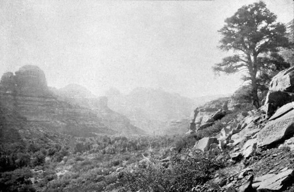
We made two camps in the Red-rock country, one at the mouth of a wild canyon near an older camp where a well had been dug and the cellar of an American house was visible. This camp was fully six miles from Schürmann's ranch and was surrounded by some of the wildest scenery that I had ever witnessed. The accompanying view (plate xcviii) was taken from a small elevation near by, and gives a faint idea of the magnificent mountains by which we were surrounded. The colors of the rocks are variegated, so that the gorgeous cliffs appear to be banded, rising from 800 to 1,000 feet sheer on all sides. These rocks had weathered into fantastic shapes suggestive of cathedrals, Greek temples, and sharp steeples of churches extending like giant needles into the sky. The scenery compares very favorably with that of the Garden of the Gods, and is much more extended. This place, I have no doubt, will sooner or later become popular with the sightseer, and I regard the discovery of these cliffs one of the most interesting of my summer's field work.
BUREAU OF AMERICAN ETHNOLOGY—— SEVENTEENTH ANNUAL REPORT PL. XCVII PICTOGRAPHS NEAR CLIFF RANCH, VERDE VALLEY
On the sides of these inaccessible cliffs we noticed several cliff houses, but so high were they perched above us that they were almost invisible. To reach them at their dizzy altitude was impossible, but we were able to enter some caves a few hundred feet above our camp, finding in them nothing but charred mescal and other evidences of Apache camps. Their walls and entrances are blackened with smoke, but no sign of masonry was detected.
We moved our camp westward from this canyon (which, from a great cliff resembling the Parthenon, I called Temple canyon), following the base of the precipitous mountains to a second canyon, equally beautiful but not so grand, and built our fire in a small grove of scrub oak and cottonwood. In this lonely place Lloyd had lived over a winter, watching his stock, and had dug a well and erected a corral. We adopted his name for this camp and called it Lloyd canyon. There was no water in the well, but a few rods beyond it there was a pool, from which we watered our horses. On the first evening at this camp we sighted a bear, which gave the name Honanki, "Bear-house," to the adjacent ruined dwellings.
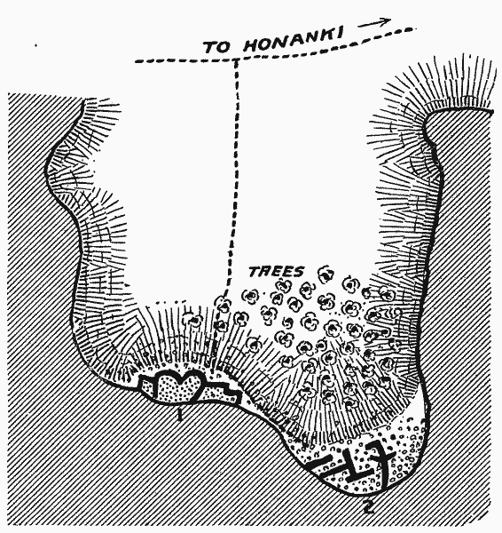
The enormous precipice of red rock west of our camp at Lloyd's corral hid Honanki from view at first, but we soon found a trail leading directly to it, and during our short stay in this neighborhood we remained camped near the cottonwoods at the entrance to the canyon, not far from the abandoned corral. Our studies of Honanki led to the discovery of Palatki (figure 247), which we investigated on our return to Temple canyon. I will, therefore, begin my description of the Red-rock cliff houses with those last discovered, which, up to the visit which I made, had never been studied by archeologists.
Palatki
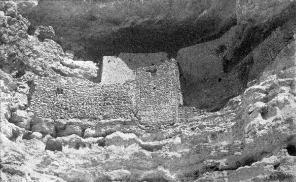
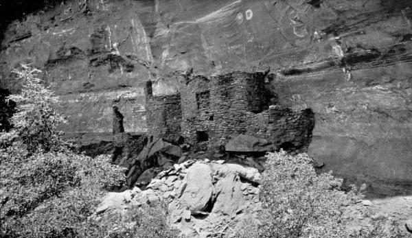
There are two neighboring ruins which I shall include in my consideration of Palatki, and these for convenience may be known as Ruin i and Ruin ii, the former situated a little eastward from the latter. They are but a short distance apart, and are in the same box canyon. Ruin i (plate xcix) is the better preserved, and is a fine type of the compact form of cliff dwellings in the Red-rock country.
This ruin is perched on the top of a talus which has fallen from the cliff above, and is visible for some distance above the trees, as one penetrates the canyon. It is built to the side of a perpendicular wall of rock which, high above its tallest walls, arches over it, sheltering the walls from rain or eroding influences. From the dry character of the earth on the floors I suspect that for years not a drop of water has penetrated the inclosures, although they are now roofless.
A highly characteristic feature of Ruin i is the repetition of rounded or bow-shape front walls, occurring several times in their length, and arranged in such a way as to correspond roughly to the inclosures behind them. By this arrangement the size of the rooms was increased and possibly additional solidity given to the wall itself. This departure from a straight wall implies a degree of architectural skill, which, while not peculiar to the cliff dwellings of the Red-rocks, is rarely found in southern cliff houses. The total length of the front wall of the ruin, including the part which has fallen, is approximately 120 feet, and the altitude of the highest wall is not far from 30 feet.
Fig. 247—Ground plan of Palatki (Ruins I and II)
From the arrangement of openings in the front wall at the highest part there is good evidence of the former existence of two stories. At several points the foundation of the wall is laid on massive bowlders, which contribute to the height of the wall itself. The masonry is made up of irregular or roughly squared blocks of red stone laid in red clay, both evidently gathered in the immediate neighborhood of the ruin. The building stones vary in size, but are as a rule flat, and show well directed fractures as if dressed by hammering. In several places there still remains a superficial plastering, which almost conceals the masonry. The blocks of stone in the lower courses are generally more massive than those higher up; this feature, however, whether considered as occurring here or in the cliff houses of Mesa Verde, as pointed out by Nordenskiöld, seems to me not to indicate different builders, but is due simply to convenience. There appears to be no regularity in the courses of component blocks of stone, and when necessity compelled, as in the courses laid on bowlders, which serve as a foundation, thin wedges of stone, or spalls, were inserted in the crevices. The walls are vertical, but the corners are sometimes far from perpendicular.
BUREAU OF AMERICAN ETHNOLOGY—— SEVENTEENTH ANNUAL REPORT PL. XCVIII THE RED ROCKS; TEMPLE CANYON
The interior of the ruin is divided into a number of inclosures by partitions at right angles to the front wall, fastening it to the face of the cliff. This I have lettered, beginning at the extreme right inclosure with A. The inclosure has bounding walls, built on a bowlder somewhat more than six feet high. It has no external passageway, and probably the entrance was from the roof. This inclosure communicates by a doorway directly with the adjoining chamber, B. The corner of this room, or the angle made by the lateral with the front walls, is rounded, a constant feature in well-built cliff houses. No windows exist, and the upper edge of both front and lateral walls is but slightly broken.
The front wall of inclosure B bulges into bow-shape form, and was evidently at least two stories high. This wall is a finely laid section of masonry, composed of large, rough stones in the lower courses, upon which smaller, roughly hewn stones are built. It is probable, from the large amount of débris in the neighborhood, that formerly there were rows of single-story rooms in front of what are now the standing walls, but the character of their architecture is difficult to determine with certainty. Their foundations, although partially covered, are not wholly concealed.
The front wall of inclosure B is pierced by three openings, the largest of which is a square passageway into the adjoining room, and is situated in the middle of the curved wall. A wooden lintel, which had been well hewn with stone implements, still remains in place above this passageway, and under it the visitor passes through a low opening which has the appearance of having been once a doorway. Above this entrance, on each side, in the wall, is a square hole, which originally may have been the points of support of floor beams. Formerly, likewise, there was a large square opening above the middle passageway, but this has been closed with masonry, leaving in place the wooden beam which once supported the wall above. The upper edge of the front wall of inclosure B is level, and is but little broken except in two places, where there are notches, one above each of the square holes already mentioned. It is probable that these depressions were intended for the ends of the beams which once supported a combined roof and floor.
On the perpendicular wall which forms the rear of inclosure B, many feet above the top of the standing front walls, there are several pictographs of Apache origin. The height of these above the level of the former roof would appear to indicate the existence of a third story, for the hands which drew them must have been at least 15 feet above the present top of the standing wall.
The front of C is curved like that of inclosure B, and is much broken near the foundations, where there is a passageway. There is a small hole on each side of a middle line, as in B, situated at about the same level as the floor, indicating the former position of a beam. Within the ruin there is a well-made partition separating inclosures B and C.
The size of room D is much less than that of B or C, but, with the exception of a section at the left, the front wall has fallen. The part which remains upright, however, stands like a pinnacle, unconnected with the face of the cliff or with the second-story wall of inclosure C. It is about 20 feet in height, and possibly its altitude appears greater than it really is from the fact that its foundations rest upon a bowlder nearly six feet high (plate cx).
The foundations of rooms E and F (plate c) are built on a lower level than those of B and C or D, and their front walls, which are really low, are helped out by similar bowlders, which serve as foundations. The indications are that both these inclosures were originally one story in height, forming a wing to the central section of the ruin, which had an additional tier of rooms. There is an entrance to F at the extreme left, and the whole room was lower than the floor of the lower stories of B, C, and D.
The most conspicuous pictograph on the cliff above Ruin i of Palatki, is a circular white figure, seen in the accompanying illustration. This pictograph is situated directly above the first room on the right, A, and was apparently made with chalk, so elevated that at present it is far above the reach of a person standing on any of the walls. From its general character I am led to believe that it was made by the Apache and not by the builders of the pueblo.
There were no names of white visitors anywhere on the walls of Palatki, which, so far as it goes, affords substantial support of my belief that we were the first white men to visit this ruin. While it can not be positively asserted that we were the original discoverers of this interesting building, there is no doubt that I was the first to describe it and to call attention to its highly characteristic architectural plan.
The walls of Palatki are not so massive as those of the neighboring Honanki, and the number of rooms in both ruins which form Palatki is much smaller. Each of these components probably housed not more than a few families, while several phratries could readily be accommodated in Honanki.
BUREAU OF AMERICAN ETHNOLOGY—— SEVENTEENTH ANNUAL REPORT PL. XCIX PALATKI (RUIN I)
The second Palatki ruin is well preserved, and as a rule the rooms, especially those in front, have suffered more from vandalism and from the elements than have those of Ruin i. The arrangement of the rooms is somewhat different from that of the more exposed eastern ruin, to which it undoubtedly formerly belonged.
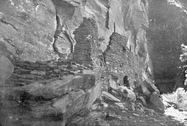
Ruin ii lies in a deep recess or cave, the roof of which forms a perfect arch above the walls. It is situated a few hundred feet to the west, and is easily approached by following the fallen débris at the foot of a perpendicular cliff. The front walls have all fallen, exposing the rear wall of what was formerly a row of rooms, as shown in the accompanying illustration (plate ci). There are evidences that this row of rooms was but a single story in height, while those behind it have indications of three stories. Ruin ii is more hidden by the trees and by its obscure position in a cavern than the former, but the masonry in both is of the same general character.
On approaching Ruin ii from Ruin i there is first observed a well-made though rough wall, as a rule intact, along which the line of roof and flooring can readily be traced (plate ci). In front of this upright wall are fragments of other walls, some standing in unconnected sections, others fallen, their fragments extending down the sides of the talus among the bushes. It was observed that this wall is broken by an entrance which passes into a chamber, which may be called A, and two square holes are visible, one on each side, above it. These holes were formerly filled by two logs, which once supported the floor of a second chamber, the line of which still remains on the upright wall. The small square orifice directly above the entrance is a peephole.
In examining the character of the wall it will be noticed that its masonry is in places rough cast, and that there was little attempt at regularity in the courses of the component stones, which are neither dressed nor aligned, although the wall is practically vertical.
At one point, in full view of the observer, a log is apparently inserted in the wall, and if the surrounding masonry be examined it will be found that an opening below it had been filled in after the wall was erected. It is evident, from its position relatively to the line indicating the roof, that this opening was originally a passageway from one room to another. Passing back of the standing wall an inclosure (room A) is entered, one side of which is the rock of the cliff, while the other three bounding walls are built of masonry, 20 feet high. This inclosure was formerly divided into an upper and a lower room by a partition, which served as the roof of the lower and the floor of the upper chambers. Two beams stretched across this inclosure about six feet above the débris of the present floor, and the openings in the walls, where these beams formerly rested, are readily observed. In the same way the beam-holes of the upper story may also be easily seen on the top of the wall. Between the rear wall of this inclosure and the perpendicular cliff there was a recess which appears to have been a dark chamber, probably designed for use as a storage room or granary. The configuration of the cliff, which forms the major part of the inclosing wall of this chamber, imparts to it an irregular or roughly triangular form.
The entire central portion of the ruin is very much broken down, and the floor is strewn to a considerable depth with the débris of fallen walls. On both sides there are nicely aligned, smoothly finished walls, with traces of beams on the level of former floors. Some of these bounding walls are curved; others are straight, and in places they rise 20 feet. Marks of fire are visible everywhere; most of the beams have been wrenched from their places, as a result of which the walls have been much mutilated, badly cracked, or thrown down.
There are no pictographs near this ruin, and no signs of former visits by white men.
Midway between Honanki and the second Palatki ruin a small ancient house of the same character as the latter was discovered. This ruin is very much exposed, and therefore the walls are considerably worn, but six well-marked inclosures, indicative of former rooms, were readily made out. No overarching rock shielded this ruin from the elements, and rubble from fallen walls covers the talus upon which it stands. The adobe mortar between the stones is much worn, and no fragment of plastering is traceable within or without. This evidence of the great weathering of the walls of the ruin is not considered indicative of greater age than the better preserved ruins in the neighborhood, but rather of exposure to the action of the elements. Not only are the walls in a very poor condition, but also the floors show, from the absence of dry soil upon them, that the whole ruin has suffered greatly from the same denudation. There are no fragments of pottery about it, and small objects indicating former habitation are also wanting. A cedar had taken root where the floor once was, and its present great size shows considerable age. If any pictographs formerly existed in the adjacent cliff they have disappeared. There is likewise no evidence that the Apache had ever sought it for shelter, or if they had, their occupancy occurred so long ago that time has effaced all evidence of their presence.
Honanki
The largest ruin visited in the Red-rock country was called, following Hopi etymology, Honanki; but the nomenclature was adopted not because it was so called by the Hopi, but following the rule elsewhere suggested.
BUREAU OF AMERICAN ETHNOLOGY—— SEVENTEENTH ANNUAL REPORT PL. C PALATKI (RUIN I)
This ruin lies under a lofty buttress of rock westward from Lloyd's canyon, which presented the only available camping place in its neighborhood. At the time of my visit there was but scanty water in the canyon and that not potable except for stock. We carried with us all the water we used, and when this was exhausted were obliged to retrace our steps to Oak creek. There are groves of trees in the canyon and evidences that at some seasons there is an abundant water supply. A corral had been made and a well dug near its mouth, but with these exceptions there were no evidences of previous occupancy by white men. We had hardly pitched our camp before tracks of large game were noticed, and before we left we sighted a bear which had come down to the water to drink, but which beat a hasty retreat at our approach. As previously stated, the knowledge of this ruin was communicated to me by Mr Schürmann.
Fig. 248—Ground plan of Honanki
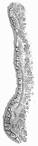
The Honanki ruin (figure 248) extends along the base of the cliff for a considerable distance, and may for convenience of description be divided into two sections, which, although generally similar, differ somewhat in structural features. The former is lineal in its arrangement, and consists of a fringe of houses extending along the base of the cliff at a somewhat lower level than the other. The walls of this section were for the greater part broken, and at no place could anything more than the foundation of the front wall be detected, although fragments of masonry strewed the sides of the declivity near its base. The house walls which remain are well-built parallel spurs constructed at right angles to the cliff, which served as the rear of all the chambers. At the extreme right end of this row of rooms, situated deep in a large cavern with overhanging roof, portions of a rear wall of masonry are well preserved, and the lateral walls of one or two chambers in this portion of the ruin are still intact. Straggling along from that point, following the contour of the base of the cliff under which it lies, there extends a long row of rooms, all destitute of a front wall.
The first division (plate cii), beginning with the most easterly of the series, is quite hidden at one end in a deep cavern. At this point the builders, in order to obtain a good rear wall to their rooms, constructed a line of masonry parallel with the face of the cliff. At right angles to this construction, at the eastern extremity, there are remnants of a lateral wall, but the remainder had tumbled to the ground. The standing wall of z is not continuous with that of the next room, y, and apparently was simply the rear of a large room with the remains of a lateral wall at right angles to it. The other walls of this chamber had tumbled into a deep gorge, overgrown with bushes which conceal the fragments. This building is set back deeply in the cave, and is isolated from the remaining parts of the ruin, although at the level which may have been its roof there runs a kind of gallery formed by a ledge of rock, plastered with adobe, which formerly connected the roof with the rest of the pueblo. This ledge was a means of intercommunication, and a continuation of the same ledge, in rooms s, t, and u, supported the rafters of these chambers. At u there are evidences of two stories or two tiers of rooms, but those in front have fallen to the ground.
The standing wall at u is about five feet high, connected with the face of the cliff by masonry. The space between it and the cliff was not large enough for a habitable chamber, and was used probably as a storage place. In front of the standing wall of room u there was another chamber, the walls of which now strew the talus of the cliff.
The highest and best preserved room of the second series of chambers at Honanki is that designated p, at a point where the ruin reached an elevation of 20 feet. Here we have good evidence of rooms of two stories, as indicated by the points of insertion of the beams of a floor, at the usual levels above the ground. In fact, it is probable that the whole section of the ruin was two stories high throughout, the front walls having fallen along the entire length. From the last room on the left to the eastern extremity of the line of houses which leads to the main ruin of Honanki, no ground plans were detected at the base of the cliffs, but fallen rocks and scattered débris are strewn over the whole interval.
The eastern part of the main ruin of Honanki, however, lies but a short distance west of that described, and consists of many similar chambers, arranged side by side. These are lettered in the diagram h to u, beginning with h, which is irregularly circular in form, and ends with a high wall, the first to be seen as one approaches the ruin from Lloyd canyon. This range of houses is situated on a lower foundation and at a lower level than that of the main quarter of Honanki, and a trail runs along so close to the rooms that the whole series is easily visited without much climbing. No woodwork remains in any of these rooms, and the masonry is badly broken in places either by natural agencies or through vandalism.
Beginning with h, the round room, which adjoins the main quarter of Honanki, we find much in its shape to remind us of a kiva. The walls are in part built on foundations of large bowlders, one of which formed the greater part of the front wall. This circular room was found to be full of fallen débris, and could not be examined without considerable excavation. If it were a kiva, which I very much doubt, it is an exception among the Verde valley ruins, where no true kiva has yet been detected.[27]
BUREAU OF AMERICAN ETHNOLOGY—— SEVENTEENTH ANNUAL REPORT PL. CI FRONT WALL OF PALATKI (RUIN II)
Following h there is an inclosure which originally may have been a habitable room, as indicated by the well-constructed front wall, but it is so filled with large stones that it is difficult to examine its interior. On one side the wall, which is at right angles to the face of the cliff, is 10 feet high, and the front wall follows the surface of a huge bowlder which serves as its foundation.
Room i is clearly defined, and is in part inclosed by a large rock, on top of which there still remains a fragment of a portion of the front wall. A spur of masonry connects this bowlder with the face of the cliff, indicating all that remains of the former division between rooms i and j. An offshoot from this bowlder, in the form of a wall 10 feet high, formerly inclosed one side of a room. In the rear of chamber j there are found two receptacles or spaces left between the rear wall and the face of the cliff, while the remaining wall, which is 10 feet high, is a good specimen of pueblo masonry.
The two side walls of room k are well preserved, but the chamber resembles the others of the series in the absence of a front wall. In this room, however, there remains what may have been the fragment of a rear wall parallel with the face of the cliff. This room has also a small cist of masonry in one corner, which calls to mind certain sealed cavities in the cavate dwellings.
The two side walls of m and n are respectively eight and ten feet high. There is nothing exceptional in the standing walls of room o, one of which, five feet in altitude, still remains erect. Room p has a remnant of a rear wall plastered to the face of the cliff.
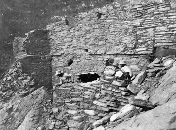
Room r (plate ciii) is a finely preserved chamber, with lateral walls 20 feet high, of well-constructed masonry, that in the rear, through which there is an opening leading into a dark chamber, occupying the space between it and the cliff. It is braced by connecting walls at right angles to the face of the solid rock.
At s, the face of the cliff forms a rear wall of the room, and one of the side walls is fully 20 feet high. The points of insertion of the flooring are well shown, about 10 feet from the ground, proving that the ruin at this point was at least two stories high.
Two walled inclosures, one within the other, characterize room u. On the cliff above it there is a series of simple pictographs, consisting of short parallel lines pecked into the rock, and are probably of Apache origin. This room closes the second series, along the whole length of which, in front of the lateral walls which mark different chambers, there are, at intervals, piles of débris, which enabled an approximate determination of the situation of the former front wall, fragments of the foundations of which are traceable in situ in several places.
The hand of man and the erosion of the elements have dealt harshly with this portion of Honanki, for not a fragment of timber now remains in its walls. This destruction, so far as human agency is concerned, could not have been due to white men, but probably to the Apache, or possibly to the cliff villagers themselves at the time of or shortly after the abandonment of the settlement.
From the second section of Honanki we pass to the third and best-preserved portion of the ruins (figure 249), indicated in the diagram from a to g. To this section I have referred as the "main ruin," for it was evidently the most populous quarter of the ancient cliff dwelling. It is better preserved than the remainder of Honanki, and is the only part in which all four walls of the chambers still remain erect. Built at a higher level than the series of rooms already considered, it must have towered above them, and possibly served as a place of retreat when danger beset the more exposed quarters of the village.
Fig. 249—The main ruin of Honanki
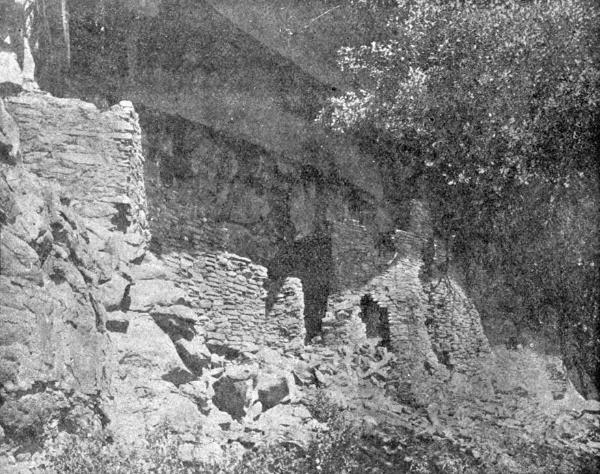
Approaching the main ruin of Honanki (plate civ) from the east, or the parts already described, one passes between the buttress on which the front wall of the rounded room h is built and a fragment of masonry on the left, by a natural gateway through which the trail is very steep. On the right there towers above the visitor a well-preserved wall of masonry, the front of room a, and he soon passes abreast of the main portion of the ruin of Honanki. This section is built in a huge cavern, the overhanging roof of which, is formed by natural rock, arching far above the tops of the highest walls of the pueblo and suggesting the surroundings of the "Cliff Palace" of Mesa Verde, so well described by the late Baron G. Nordenskiöld in his valuable monograph on the ruins of that section of southern Colorado. The main ruin of Honanki is one of the largest and best preserved architectural monuments of the former people of Verde valley that has yet been described. Although somewhat resembling its rival, the well-known "Casa Montezuma" of Beaver creek, its architecture is dissimilar on account of the difference in the form of the cavern in which it is built and the geological character of the surrounding cliffs. Other Verde ruins may have accommodated more people, when inhabited, but none of its type south of Canyon de Chelly have yet been described which excel it in size and condition of preservation. I soon found that our party were not the first whites who had seen this lonely village, as the names scribbled on its walls attested; but so far as I know it had not previously been visited by archeologists.
BUREAU OF AMERICAN ETHNOLOGY—— SEVENTEENTH ANNUAL REPORT PL. CII HONANKI (RUIN II)
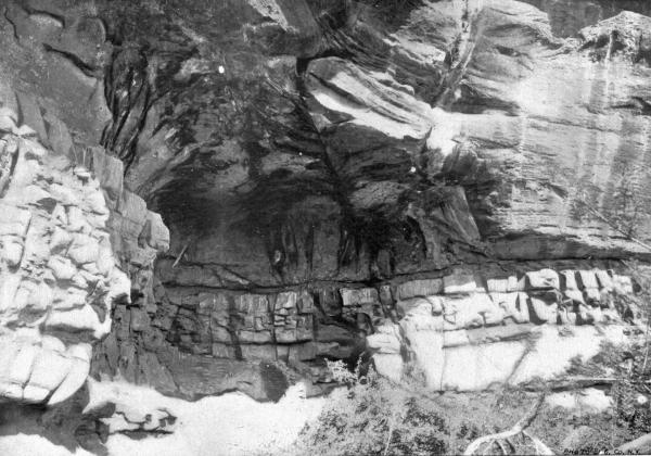
In the main portion of Honanki we found that the two ends of the crescentic row of united rooms which compose it are built on rocky elevations, with foundations considerably higher than those of the rooms in the middle portion of the ruins. The line of the front wall is, therefore, not exactly crescentic, but irregularly curved (figure 249), conforming to the rear of the cavern in which the houses are situated. About midway in the curve of the front walls two walls indicative of former rooms extend at an angle of about 25° to the main front wall. All the component rooms of the main part of Honanki can be entered, some by external passageways, others by doorways communicating with adjacent chambers. None of the inclosures have roofs or upper floors, although indications of the former existence of both these structural features may readily be seen in several places. Although wooden beams are invariably wanting, fragments of these still project from the walls, almost always showing on their free ends, inside the rooms, the effect of fire. I succeeded in adding to the collection a portion of one of these beams, the extremity of which had been battered off, evidently with a stone implement. In the alkaline dust which covered the floor several similar specimens were seen.
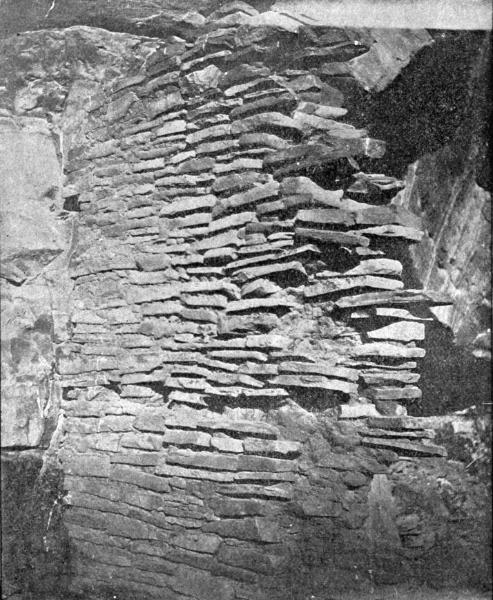
The stones which form the masonry of the wall (figure 250) were not, as a rule, dressed or squared before they were laid with adobe mortar, but were generally set in place in the rough condition in which they may still be obtained anywhere under the cliff.
All the mortar used was of adobe or the tenacious clay which serves so many purposes among the Pueblos. The walls of the rooms were plastered with a thick layer of the same material. The rear wall of each room is the natural rock of the cliff, which rises vertically and has a very smooth surface. The great natural archway which covers the whole pueblo protects it from wind and rain, and as a consequence, save on the front face, there are few signs of natural erosion. The hand of man, however, has dealt rudely with this venerable building, and many of the walls, especially of rooms which formerly stood before the central portion, lie prone upon the earth; but so securely were the component stones held together by the adobe that even after their fall sections of masonry still remain intact.
Fig. 250—Structure of wall of Honanki
There are seven walled inclosures in the main part of Honanki, and as each of these was formerly at least two stories high there is substantial evidence of the former existence of fourteen rooms in this part of the ruin. There can be little doubt that there were other rooms along the front of the central portion, and the fallen walls show them to have been of large size. It would likewise appear that the middle part was higher than the two wings, which would increase the number of chambers, so that with these additions it may safely be said that this part of Honanki alone contained not far from twenty rooms.
BUREAU OF AMERICAN ETHNOLOGY—— SEVENTEENTH ANNUAL REPORT PL. CIII WALLS OF HONANKI
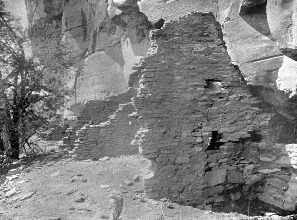
The recess in the cliff in which the ruin is situated is lower in the middle than at either side, where there are projecting ledges of rock which were utilized by the builders in the construction of the foundations, the line of the front wall following the inequalities of the ground. It thus results that rooms g, a, b, and a part of c, rise from a foundation about breast high, or a little higher than the base of rooms d, e, and f.
The front wall of a has for its foundation a spur or ledge of rock, which is continued under b and a part of c. The corner or angle of this wall, facing the round chamber, is curved in the form of a tower, a considerable section of its masonry being intact. Near the foundation and following the inequalities of the rock surface the beginning of a wall at right angles to the face of the ruin at this point is seen. A small embrasure, high above the base of the front wall, on the side by which one approaches the ruin from the east, and two smaller openings on the same level, looking out over the valley, suggest a floor and lookouts. The large square orifice in the middle of the face of the wall has a wooden lintel, still in place; the opening is large enough for use as a door or passageway. The upper edge of the front wall is somewhat irregular, but a notch in it above the square opening is conspicuous.
The rear wall of room a was the face of the cliff, formed of solid rock without masonry and very much blackened by smoke from former fires. As, however, there is evidence that since its destruction or abandonment by its builders this ruin has been occupied as a camping place by the Apache, it is doubtful to which race we should ascribe this discoloration of the walls by soot.
On the ground floor there is a passageway into chamber b, which is considerably enlarged, although the position of the lintel is clearly indicated by notches in the wall. The beam which was formed there had been torn from its place and undoubtedly long ago used for firewood by nomadic visitors. The open passageway, measured externally, is about 15 feet above the foundation of the wall, through which it is broken, and about 8 feet below the upper edge of the wall.
Room b is an irregular, square chamber, two stories high, communicating with a and c by passages which are enlarged by breakage in the walls. A small hole in the front wall, about 6 feet from the floor, opens externally to the air. The walls are, in general, about 2 feet thick, and are composed of flat red stones laid in clay of the same color. The cliff forms the rear wall of the chamber. The clay at certain places in the walls, especially near the insertions of the beams and about the window openings, appears to have been mixed with a black pitch, which serves to harden the mixture.
Room c is the first of a series of chambers, with external passageways, but its walls are very much broken down, and the openings thereby enlarged. The front wall is almost straight and in one place stands 30 feet, the maximum height of the standing wall of the ruins. In one corner a considerable quantity of ashes and many evidences of fire, some of which may be ascribed to Apache occupants, was detected. A wooden beam, marking the line of the floor of a second story, was seen projecting from the front wall, and there are other evidences of a floor at this level. Large beams apparently extended from the front wall to the rear of the chamber, where they rested on a ledge in the cliff, and over these smaller sticks were laid side by side and at right angles to the beams. These in turn supported either flat stones or a layer of mud or clay. The method of construction of one of these roofs is typical of a Tusayan kiva, where ancient architectural forms are adhered to and best preserved.
The entrance to room d is very much enlarged by the disintegration of the wall, and apparently there was at this point a difference in level of the front wall, for there is evidence of rooms in advance of those connected with the chambers described, as shown by a line of masonry, still standing, parallel to the front face of inclosures c and d.
Room e communicates by a doorway with the chamber marked f, and there is a small window in the same partition. This room had a raised banquette on the side toward the cliff, recalling an arrangement of the floor similar to that in the cavate dwellings opposite Squaw mountain which I have described. This platform is raised about three feet above the remainder of the floor of f, and, like it, is strewn with large slabs of stone, which have fallen from the overhanging roof. In the main floor, at one corner, near the platform, there is a rectangular box-like structure made of thin slabs of stone set on edge, suggesting the grinding bins of the Pueblos. Room f communicates with g by a passageway which has a stone lintel. The holes in the walls, in which beams were once inserted, are seen in several places at different levels above the floor. The ends of several beams, one extremity of which is invariably charred, were found set in the masonry, and others were dug from the débris in the floor.
As a result of the curve in the front wall of the ruin at that point, the shape of room f is roughly quadrate, with banquettes on two sides. There are six large beam holes in the walls, and the position of the first floor is well shown on the face of the partition, separating f from g. The passageway from one of these rooms to the other is slightly arched.
Room g is elongated, without an external entrance, and communicates with f by a small opening, through which it is very difficult to crawl. Its longest dimension is almost at right angles to the front face of the remaining rooms, and it is raised above them by its foundation on an elevated rock like that of a, b, and c. There is a small, square, external opening which may have served as the position of a former beam or log. The upper level of the front wall is more or less broken down in places, and formerly may have been much higher. Beyond g a spur of masonry is built at right angles to the cliff, inclosing a rectangular chamber at the end of the ruin which could not be entered. Possibly in former times it was accessible by means of a ladder from the roof, whence communication with other portions of the structure was also had.
BUREAU OF AMERICAN ETHNOLOGY—— SEVENTEENTH ANNUAL REPORT PL. CIV APPROACH TO MAIN PART OF HONANKI
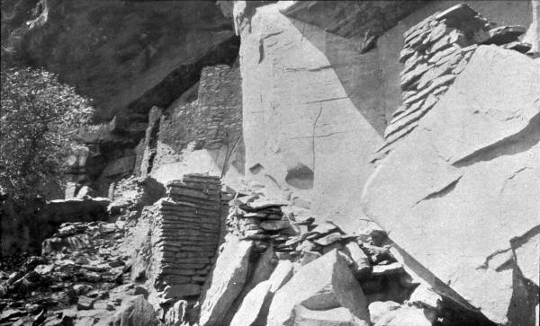
A short distance beyond the westernmost rooms of Honanki, almost covered with bushes and adjoining the base of the cliff, there is a large ash heap in which are many fragments of pottery and the bones of various animals. It is probable that excavation in this quarter would reveal many interesting objects. In the cliffs above this ash heap, far beyond reach, there is a walled niche which has never been disturbed. This structure is similar to those near the cavate dwellings, and when opened will probably be found to contain buried mortuary objects of interesting character. I did not disturb this inclosure, inasmuch as I had no ladders or ropes with which to approach it.
It is very difficult to properly estimate, from the number of rooms in a cliff house, the former population, and as a general thing the tendency is rather to overstate than to fall short of the true total. In a pueblo like Hano, on the first or east mesa of Tusayan, for instance, there are many uninhabited rooms, and others serve as storage chambers, while in places the pueblo has so far fallen into ruin as to be uninhabitable. If a pueblo is very much concentrated the population varies at different seasons of the year. In summer it is sparsely inhabited; in winter it is rather densely populated. While Palatki and Honanki together had rooms sufficient to house 500 people, I doubt whether their aggregate population, ever exceeded 200. This estimate, of course, is based on the supposition that these villages were contemporaneously inhabited.
The evidences all point to a belief, however, that they were both permanent dwelling places and not temporary resorts at certain seasons of the year.
The pictographs on the face of the cliff above Honanki are for the greater part due to the former Apache occupants of the rooms, and are situated high above the tops of the walls of the ruin. They are, as a rule, drawn with white chalk, which shows very clearly on the red rock, and are particularly numerous above room g. The figure of a circle, with lines crossing one another diametrically and continued as rays beyond the periphery, possibly represent the sun. Many spiral figures, almost constant pictographs in cliff ruins, are found in several places. Another strange design, resembling some kind of insect, is very conspicuous.
A circle painted green and inclosed in a border of yellow is undoubtedly of Apache origin. There is at one point a row of small pits, arranged in line, suggesting a score or enumeration of some kind, and a series of short parallel lines of similar import was found not far away. This latter method of recording accounts is commonly used at the present time in Tusayan, both in houses and on cliffs; and one of the best of these, said to enumerate the number of Apache killed by the Hopi in a raid many years ago, may be seen above the trail by which the visitor enters the pueblo of Hano on the East Mesa. The names of several persons scratched on the face of the cliff indicate that Americans had visited Honanki before me.
The majority of the paleoglyphs at both Palatki and Honanki are of Apache origin, and are of comparatively modern date, as would naturally be expected. In some instances their colors are as fresh as if made a few years ago, and there is no doubt that they were drawn after the building was deserted by its original occupants. The positions of the pictographs on the cliffs imply that they were drawn before the roofs and flooring had been destroyed, thus showing how lately the ruin preserved its ancient form. In their sheltered position there seems to be no reason why the ancient pictographs should not have been preserved, and the fact that so few of the figures pecked in the cliff now remain is therefore instructive.
One of the first tendencies of man in visiting a ruin is to inscribe his name on its walls or on neighboring cliffs. This is shared by both Indians and whites, and the former generally makes his totem on the rock surface, or adds that of his gods, the sun, rain-cloud, or katcinas. Inscriptions recording events are less common, as they are more difficult to indicate with exactitude in this system of pictography. The majority of ancient pictographs in the Red-rock country, like those I have considered in other parts of Verde valley, are identical with picture writings now made in Tusayan, and are recognized and interpreted without hesitation by the Hopi Indians. In their legends, in which the migrations of their ancestors are recounted, the traditionists often mention the fact that their ancestors left their totem signatures at certain points in their wanderings. The Patki people say that you will find on the rocks of Palatkwabi, the "Red Land of the South" from which they came, totems of the rain-cloud, sun, crane, parrot, etc. If we find these markings in the direction which they are thus definitely declared to exist, and the Hopi say similar pictures were made by their ancestors, there seems no reason to question such circumstantial evidence that some of the Hopi clans once came from this region.[28]
One of the most interesting of the pictographs pecked in the rock is a figure which, variously modified, is a common decoration on cliff-dweller pottery from the Verde valley region to the ruins of the San Juan and its tributaries. This figure has the form of two concentric spirals, the ends of which do not join. As this design assumes many modifications, it may be well to consider a few forms which it assumes on the pottery of the cliff people and on that of their descendants, the Pueblos.
The so-called black-and-white ware, or white pottery decorated with black lines, which is so characteristic of the ceramics of the cliff-dwellers, is sometimes, as we shall see, found in ruins like Awatobi and Sikyatki; but it is so rare, as compared with other varieties, that it may be regarded as intrusive.
One of the simplest forms of the broken-line motive is a Greek fret, in which there is a break in the component square figures or where the line is noncontinuous. In the simplest form, which appears prominently on modern pottery, but which is rare or wanting on true black-and-white ware, we have two crescentic figures, the concavities of which face in different directions, but the horns overlap. This is a symbol which the participants in the dance called the Húmiskatcina still paint with pigments on their breasts, and which is used on shields and various religious paraphernalia.
A study of any large collection of decorated Pueblo ware, ancient or modern, will show many modifications of this broken line, a number of which I shall discuss more in detail when pottery ornamentation is considered. A design so distinctive and so widespread as this must certainly have a symbolic interpretation. The concentric spirals with a broken line, the Hopi say, are symbols of the whirlpool, and it is interesting to find in the beautiful plates of Chavero's Antigüedades Mexicanas that the water in the lagoon surrounding the ancient Aztec capital was indicated by the Nahuatl Indians with similar symbols.
Objects Found at Palatki and Honanki
The isolation of these ruins and the impossibility of obtaining workmen, combined with the brief visit which I was able to make to them, rendered it impossible to collect very many specimens of ancient handiwork. The few excavations which were made were limited almost wholly to Honanki, and from their success I can readily predict a rich harvest for anyone who may attempt systematic work in this virgin field. We naturally chose the interior of the rooms for excavation, and I will say limited our work to these places. Every chamber was more or less filled with débris—fragments of overturned walls, detached rock from the cliff above, dry alkaline soil, drifted sand, dust, and animal excreta. In those places where digging was possible we found the dust and guano so dry and alkaline that it was next to impossible to work for any length of time in the rooms, for the air became so impure that the workmen could hardly breathe, especially where the inclosing walls prevented ventilation. Notwithstanding this obstacle, however, we removed the accumulated débris down to the floor in one or two chambers, and examined with care the various objects of aboriginal origin which were revealed.