RUINS IN TUSAYAN
Reading edition
General Features
No region of our Southwest presents more instructive antiquities than the ancient province of Tusayan, more widely known as the Moki reservation. In the more limited use of the term, Tusayan is applied to the immediate surroundings of the Hopi pueblos, to which "province" it was given in the middle of the sixteenth century. In a broader sense the name would include an as yet unbounded country claimed by the component clans of this people as the homes of their ancestors.
The general character and distribution of Tusayan ruins (plate xvi) has been ably presented by Mr Victor Mindeleff in a previous report.[31] While this memoir is not regarded as exhaustive, it considers most of the large ruins in immediate proximity to the three mesas on which the pueblos inhabited by the Hopi are situated. It is not my purpose here to consider all Tusayan ruins, even if I were able to do so, but to supplement with additional data the observations already published on two of the most noteworthy pueblo settlements. Broadly speaking, I have attempted archeological excavations in order to obtain more light on the nature of prehistoric life in Tusayan. It may be advantageous, however, to refer briefly to some of the ruins thus far discovered in the Tusayan region as preliminary to more systematic descriptions of the two which I have chosen for special description.
The legends of the surviving Hopi contain constant references to former habitations of different clans in the country round about their present villages. These clans, which by consolidation make up the present population of the Hopi pueblos, are said to have originally entered Tusayan from regions as far eastward as the Rio Grande, and from the southern country included within the drainage of the Gila, the Salt, and their affluents. Other increments are reputed to have come from the northward and the westward, so that the people we now find in Tusayan are descendants from an aggregation of stocks from several directions, some of them having migrated from considerable distances. Natives of other regions have settled among the ancient Hopi, built pueblos, and later returned to their former homes; and the Hopi in turn have sent colonists into the eastern pueblo country.
These legends of former movements of the tribal clans of Tusayan are supplemented and supported by historical documents, and we know from this evidence that there has been a continual interchange between the people of Tusayan and almost every large pueblo of New Mexico and Arizona. Some of the ruins of this region were abandoned in historic times; others are prehistoric; many were simply temporary halting places in Hopi migrations, and were abandoned as the clans drifted together in friendship or destroyed as a result of internecine conflicts.
There is documentary evidence that in the years following the great rebellion of the Pueblo tribes in 1680, which were characterized by catastrophes of all kinds among the Rio Grande villagers, many Tanoan people fled to Tusayan to escape from their troubles. According to Niel, 4,000 Tanoan refugees, under Frasquillo, loaded with booty which they had looted from the churches, went to Oraibi by way of Zuñi, and there established a "kingdom," with their chief as ruler. How much reliance may be placed on this account is not clear to me, but there is no doubt that many Tanoan people joined the Hopi about this time, and among them were the Asa people, the ancestors of the present inhabitants of Hano pueblo, and probably the accolents of Payüpki. The ease with which two Franciscan fathers, in 1742, persuaded 441 of these to return to the Rio Grande, implies that they were not very hostile to Christianity, and it is possible that one reason they sought Tusayan in the years after the Spaniards were expelled may have been their friendship for the church party.
With the exception of Oraibi, not one of the present inhabited pueblos of Tusayan occupies the site on which it stood in the sixteenth century, and the majority of them do not antedate the beginning of the eighteenth century. The villages have shifted their positions but retained their names.
At the time of the advent of Tobar, in 1540, there was but one of the present three villages of East Mesa. This was Walpi, and at the period referred to it was situated on the terrace below the site of the present town, near the northwestern base of the mesa proper. Two well-defined ruins, called Kisakobi and Küchaptüvela, are now pointed out as the sites of Old Walpi. Of these Küchaptüvela is regarded as the older.
Judging by their ruins these towns were of considerable size. From their exposed situation they were open to the inroads of predatory tribes, and from these hostile raids their abandonment became necessary. From Küchaptüvela the ancient Walpians moved to a point higher on the mesa, nearer its western limit, and built Kisakobi, where the pueblo stood in the seventeenth century. There is evidence that a Spanish mission was erected at this point, and the place is sometimes called Nüshaki, a corruption of "Missa-ki," Mass-house. From this place the original nucleus of Walpians moved to the present site about the close of the seventeenth century. Later the original population was joined by other phratries, some of which, as the Asa, had lived in the cliff-houses of Tségi, or Canyon de Chelly, as late as the beginning of the eighteenth century. This, however, is not the place to trace the composition of the different modern villages.
Sichomovi was a colony from Walpi, founded about 1750, and Hano was built not earlier than 1700. The former was settled by the Badger people, later joined by a group of Tanoan clans called the Asa, from the Rio Grande, who were invited to Tusayan to aid the Hopi in resisting the invasions of northern nomads.
By the middle of the eighteenth century the population of the province of Tusayan was for the first time distributed in the seven pueblos now inhabited. No village has been deserted since that time, nor has any new site been occupied.
In order that the reader may have an idea of the Tusayan pueblos at the time mentioned, an account of them from a little-known description by Morfi in 1782 is introduced:[32]
Morfi's account of the Tusayan pueblos
Quarenta y seis leguas al Poniente de Zuñi, con alguna inclinacion al N. O. están los tres primeros pueblos de la provincia de Moqui, que en el dia en el corto distrito de 4-1/2 leguas (112 recto) tiene siete pueblos en tres mesas ó peñoles que corren linea recta de Oriente á Poniente.
Tanos[33]
En la punta occidental de la primera, y en la mas estrecho de su eminencia están situados tres de los quales el primero es el de Tanos (alli dicen Tegüas), cuyas moradores tienen idioma particular y distinto del Moquino. Es pueblo regular con un plaza en el centro, y un formacion de calles. Tendrá 110 familias.
El segundo[34] pueblo dista del precedente como un tiro de piedra, es de fundacion moderna, y se compondrá de mas 15 familias que se retiraron aqui de:
Gualpi
Gualpi que dista del anterior un tiro de fusil, es mas grande y populoso que los dos anteriores, puede tener hasta 200 familias. Estas tres pueblos tienen poco caballada, y algunas vacas; pero mucho ganado lanar.
Mosasnabi[35]
Al poniente de esta mesa, y á legua y media de distancia está la segunda, cuyo intermedio es un (112 v.) arenal, que ertrando un poco en ella la divide en dos brazas. En el septentrional, que es el mas inmediata á Gualpi hay dos anillos distantes entre si un tiro de piedra. En la cima del primero está situado el pueblo de Mosasnabi compuesto de 50 familias poco mas ó menos.
Xipaolabi[36]
En la cumbre del secundo cerrito se fundó el quinto pueblo llamado Xipaolabi, que tendrá solo 14 familias: está casi arruinado, porque sus vecinos se han trasladado al brazo austral de la mesa y formaron el sexto pueblo llamado:
Xongopabi[37]
Xongopabi goza mejor situacion que todos los demas, tienen tres quarteles mui bien dispuestos y en ellas unas 60 familias. Estos tres pueblos tienen mas caballada que los primeros y mucho ganado menor.
Oraybe
Dos y media leguas al Poniente de esta mesa, está la tercera, y en sucima el septimo pueblo que llaman Oraybe. Es como la capital de la provincia, el mayor y mas bien formado de toda ella, y acaso de todas las provincias internas. Tiene once quarteles ó manzanas bien largas y dispuestos con calles á cordel yá (113 r.) todos vientos, y puede llegar su poblacion á 800 familias. Tienen buena caballada, mucho ganado menor y algun vacuno. Aunque no gozan sino una pequeña fuente de buena agua, distante del pueblo mas de una milla al Norte, han construido para suplir esta escasez, en la misma mesa, y mui inmediato à las casas seis cisternas grandes donde recoger la agua de las lluvias y nieves.
The distribution of the population of Tusayan in the seven pueblos mentioned above remained practically the same during the century between 1782 and 1882. Summer settlements for farming purposes were inhabited by the Oraibi for brief periods. Between the years 1880 and 1890 a beginning of a new distribution of Hopi families began, when one or two of the less timid erected houses near Coyote spring, at the East Mesa. The Tewa, represented by Polaka and Jakwaina, took the lead in this movement. From 1890 to the present time a large number of Walpi, Sichomovi, and Hano families have built houses in the foothills of the East Mesa and in the plain beyond the "wash." A large schoolhouse has been erected at Sun spring and a considerable number of East Mesa villagers have abandoned their mesa dwellings. In this shifting of the population the isolated house is always adopted and the aboriginal method of roof building is abandoned. The indications are that in a few years the population of the East Mesa will be settled in unconnected farmhouses with little resemblance to the ancient communal pueblo.
This movement is shared to a less extent by the Middle Mesa and Oraibi people. On my first visit to the pueblos of these mesas, in 1890, there was not a single permanent dwelling save in the ancient pueblos; but now numerous small farmhouses have been erected at or near the springs in the foothills. I mention these facts as a matter of record of progress in the life of these people in adapting themselves to the new conditions or influences by which they are surrounded. I believe that if this exodus of Hopi families from the old pueblo to the plain continues during the next two decades as it has in the last ten years, there are children now living in Walpi who will some day see it uninhabited.
This disintegration of the Hopi phratries, by which families are separated from one another, is, I believe, a return to the prehistoric distribution of the clans, and as Walpi grew into a pueblo by a union of kindred people, so now it is again being divided and distributed, still preserving family ties in new clusters or groupings. It is thus not impossible that the sites of certain old ruins, as Sikyatki, deserted for many years, will again be built upon if better suited for new modes of life. The settlement near Coyote spring, for instance, is not far from the old site of a former home of the Tanoan families, who went to Tusayan in the beginning of the eighteenth century, and the people who inhabit these new houses are all Tanoan descendants of the original contingent.
In order to become familiar with the general character of Tusayan ruins, I made a brief reconnoissance of those mentioned in the following list, from which I selected Awatobi and Sikyatki as places for a more exhaustive exploration. This list is followed by a brief mention of those which I believe would offer fair opportunities for a continuation of the work inaugurated. The ruins near Oraibi were not examined and are therefore omitted, not that they are regarded as less important, but because I was unable to undertake a study of them in the limited time at my disposal. There are also many ruins in Tusayan, north of the inhabited pueblos, which have never been described, and would well repay extended investigation. Some of these, as the ruins at the sacred spring called Kishuba, are of the utmost traditional importance.
I. Middle Mesa ruins—(1) Old Shuñopovi; (2) Old Mishoñinovi; (3) Shitaumû; (4) Chukubi; (5) Payüpki.
II. East Mesa ruins—(1) Kisakobi; (2) Küchaptüvela; (3) Küküchomo; (4) Tukinobi; (5) Kachinba; (6) Sikyatki.
III. Ruins in Keam's canyon.
IV. Jeditoh valley ruins—(1) Bat-house; (2) Jeditoh, Kawaika; (3) Horn-house; (4) Awatobi; Smaller Awatobi.
This method of classification is purely geographical, and is adopted simply for convenience; but there are one or two facts worthy of mention in regard to the distribution of ruins in these four sections. The inhabited pueblos, like the ruins, are, as a rule, situated on the eastern side of their respective mesas, or on the cliffs or hills which border the adjacent plains on the west. This uniformity is thought to have resulted from a desire to occupy a sunny site for warmth and for other reasons.
The pueblos at or nearest the southern ends of the mesas were found to be best suited for habitation, consequently the present towns occupy those sites, or, as in the case of the Jeditoh series, the pueblo at that point was the last abandoned. The reason for this is thought to be an attempt to concentrate on the most inaccessible sites available, which implies inroads of hostile peoples. For the same reason, likewise, the tendency was to move from the foothills to the mesa tops when these invasions began.
Early settlers near East Mesa appeared to have chosen exposed sites for their pueblos. This would imply that they feared no invasion, and legendary history indicates that the first pueblos were erected before the hostile Ute, Apache, and Navaho appeared. The early settlements on Middle Mesa were also apparently not made with an absorbing idea of inaccessibility. All the Jeditoh villages, however, were on the mesa tops, these sites having been selected evidently with a view to protection, since they were not convenient to the farms.
For many reasons it would seem that the people who occupied the now ruined Jeditoh villages were later arrivals in Tusayan than those of East and Middle Mesas, and that, as a rule, they came from the eastward, while those of Middle Mesa arrived from the south. The first colonists of all, however, appear to have been the East Mesa clans, the Bear and Snake families. If this conjecture be true, we may believe that the oldest pueblos in Tusayan were probably the house groups of the Snake clan of East Mesa, for whom their traditionists claim a northern origin.
The Middle Mesa Ruins
SHUÑOPOVI
The site of Old Shuñopovi (plate cv) at the advent of the first Spaniards, and for a century or more afterward, was at the foot of the mesa on which the present village stands. The site of the old pueblo is easily detected by the foundations of the ancient houses and their overturned walls, surrounded by mounds of soil filled with fragments of the finest pottery.
The old village was situated on a ridge of foothills east of the present town and near the spring, which is still used. On the highest point of the ridge there rise to a considerable height the massive walls of the old Spanish mission church, forming an inclosure, now used as a sheep corral. The cemeteries are near by, close to the outer walls, and among a clump of peach trees about half a mile east of the old houses. The pottery,[38] as shown by the fragments, is of the finest old Tusayan ware, cream and red being the predominating colors, while fragments of coiled and black-and-white ware are likewise common.
MISHOÑINOVI
The ruins of Old Mishoñinovi lie west of the present pueblo in the foothills, not far from the two rocky pinnacles at that point and adjacent to a spring. In strolling over the site of the old town I have noted its ground plan, and have picked up many sherds which indicate that the pottery made at that place was the fine cream-color ware for which Tusayan has always been famous. The site offers unusual opportunities for archeological studies, but excavation there is not practicable on account of the opposition of the chiefs.
Old Mishoñinovi was a pueblo of considerable size, and was probably inhabited up to the close of the seventeenth century. It was probably on this site that the early Spanish explorers found the largest pueblo of the Middle Mesa. The ruin of Shitaimovi, in the foothills near Mishoñinovi, mentioned by Mindeleff, was not visited by our party.
BUREAU OF AMERICAN ETHNOLOGY—— SEVENTEENTH ANNUAL REPORT PL. CV. SKETCH MAP OF THE MESA COUNTRY OCCUPIED BY THE HOPI INDIANS
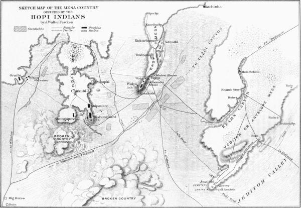
CHUKUBI
The ruin of Chukubi bears every evidence of antiquity. It is situated on one of the eastward projecting spurs of Middle Mesa, midway between Payüpki and Shipaulovi, near an excellent spring at the base of the mesa.
Chukubi was built in rectangular form, with a central plaza surrounded by rooms, two deep. There are many indications of outlying chambers, some of which are arranged in rows. The house walls are almost wholly demolished, and in far poorer state of preservation than those of the neighboring ruin of Payüpki. The evidence now obtainable indicates that it was an ancient habitation of a limited period of occupancy. It is said to have been settled by the Patuñ or Squash people, whose original home was far to the south, on Little Colorado river. A fair ground plan is given by Mindeleff in his memoir on Pueblo Architecture; but so far as known no studies of the pottery of this pueblo have ever been made.
PAYÜPKI
One of the best-preserved ruins on Middle Mesa is called Payüpki by the Hopi, and is interesting in connection with the traditions of the migration of peoples from the Rio Grande, which followed the troublesome years at the close of the seventeenth century. In the reconquest of New Mexico by the Spaniards we can hardly say that Tusayan was conquered; the province was visited and nominally subjugated after the great rebellion, but with the exception of repeated expeditions, which were often repulsed, the Hopi were practically independent and were so regarded. No adequate punishment was inflicted on the inhabitants of Walpi for the destruction of the town of Awatobi, and although there were a few military expeditious to Tusayan no effort at subjugation was seriously made.
Tusayan was regarded as an asylum for the discontented or apostate, and about the close of the seventeenth century many people from the Rio Grande fled there for refuge. Some of these refugees appear to have founded pueblos of their own; others were amalgamated with existing villages. Payüpki seems to have been founded about this period, for we find no account of it before this time, and it is not mentioned in connection with ancient migrations. In 1706 Holguin is said to have attacked the "Tanos" village between Walpi and Oraibi and forced the inhabitants to give hostages, but he was later set upon by the Tano and driven back to Zuñi. It would hardly seem possible that the pueblo mentioned could have been Hano, for this village does not lie between Oraibi and Walpi and could not have been surrounded in the way indicated in the account. Payüpki, however, not only lay on the trail between Walpi and Oraibi—about midway, as the chronicler states—but was so situated on a projecting promontory that it could easily have been surrounded and isolated from the other pueblos.
The Hopi legends definitely assert that the Payüpki people came from the "great river," the Rio Grande, and spoke a language allied to that of the people of Hano. They were probably apostates, who came from the east about 1680, but did not seem to agree well with the people of the Middle Mesa, and about 1750 returned to the river and were domiciled in Sandia, where their descendants still live. The name Payüpki is applied by the Hopi to the pueblo of Sandia as well as to the ruin on the Middle Mesa. The general appearance of the ruin of Payüpki indicates that it was not long inhabited, and that it was abandoned at a comparatively recent date. The general plan is not that common to ancient Tusayan ruins, but more like that of Hano and Sichomovi, which were erected about the time Payüpki was built. Many fragments of a kind of pottery which in general appearance is foreign to Tusayan, but which resembles the Rio Grande ware, were found on the mounds, and the walls are better preserved than those of the ancient Tusayan ruins.
A notable absence of fragments of obsidian, the presence of which in abundance is characteristic of ancient ruins, was observed on the site of Payüpki. All these evidences substantiate the Hopi legend that the Tanoan inhabitants of the village of Middle Mesa, above the trail from Walpi to Oraibi, made but a short stay in Tusayan.[39]
There is good documentary evidence that Sandia was settled by Tanoan people from Tusayan. Morfi in 1782 so states,[40] and in a copy of the acts of possession of the pueblo grants of 1748 we find still further proof of the settlement of "Moquinos" in Sandia.[41]
When Otermin returned to New Mexico in his attempted reconquest, in 1681, he reached Isleta on December 6, and on the 8th Dominguez encamped in sight of Sandia, but found the inhabitants had fled. The discord following this event drove the few surviving families of the Tiwa on their old range to Tusayan, for they were set upon by Keres and Jemez warriors on the plea that they received back the Spaniards. Possibly these families formed the nucleus of Payüpki. It was about this time, also, if we can believe Niel's story, that 4,000 Tanos went to Tusayan. It would thus appear that the Hopi Payüpki was settled in the decade 1680-1690.
The East Mesa Ruins
KÜCHAPTÜVELA AND KISAKOBI
The two ruins of Küchaptüvela and Kisakobi mark the sites of Walpi during the period of Spanish exploration and occupancy between 1540 and 1700. The former was the older. In all probability the latter had a mission church and was inhabited at the time of the great rebellion in 1680, having been founded about fifty years previously.
The former or more ancient[42] pueblo was situated on the first or lowest terrace of East Mesa, below the present pueblo, on the northern and western sides. The name Küchaptüvela signifies "Ash-hill terrace," and probably the old settlement, like the modern, was known as Walpi, "Place-of-the-gap," referring to the gap or notch (wala) in the mesa east of Hano.
Old Walpi is said to have been abandoned because it was in the shade of the mesa, but doubtless the true cause of its removal was that the site was too much exposed, commanded as it was by the towering mesa above it, and easily approached on three sides. The Walpi which was contemporary with Sikyatki was built in an exposed location, for at that time the Hopi were comparatively secure from invaders. Later, however, Apache, Ute, and Navaho began to raid their fields, and the Spaniards came in their midst again and again, forcing them to work like slaves. A more protected site was necessary, and late in the seventeenth century the Walpians began to erect houses on the mesa, which formed the nucleus of the present town. The standing walls of Old Walpi are buried in the débris, but the plans of the rooms may readily be traced. Comparatively speaking, it was a large, compact, well-built pueblo, and, from the great piles of débris in the neighborhood, would seem to have been occupied during several generations.
The pottery found in the neighborhood is the fine, ancient Tusayan ware, like that of Sikyatki and Shuñopovi. Extended excavations would reveal, I am sure, many beautiful objects and shed considerable light on the obscure history of Walpi and its early population.
After moving from Old Walpi it seems that the people first built houses on the terrace above, or on the platform extending westward from the western limits of the summit of East Mesa. The whole top of that part of the mesa is covered with house walls, showing the former existence of a large pueblo. Here, no doubt, if we can trust tradition, the mission of Walpi was built, and I have found in the débris fragments of pottery similar to that used in Mexico, and very different from ancient or modern Pueblo ware. But even Kisakobi[43] was not a safe site for the Walpians to choose for their village, so after they destroyed the mission and killed the priest they moved up to their present site and abandoned both of their former villages.
It is said that with this removal of the villagers there were found to be no easy means of climbing the precipitous walls, and that the stairway trails were made as late as the beginning of the present century. In those early days there was a ladder near where the stairway trail is now situated, and some of the older men of Walpi have pointed out to me where this ladder formerly stood.
The present plan of Walpi shows marked differences from that made twenty years ago, and several houses between the stairway trail and the Wikwaliobi kiva, on the edge of the mesa, which have now fallen into ruin, were inhabited when I first visited Walpi in 1890. The buildings between the Snake kiva and the Nacab kiva are rapidly becoming unsafe for habitation, and most of these rooms will soon be deserted. As many Walpi families are building new houses on the plain, it needs no prophet to predict that the desertion of the present site of Walpi will progress rapidly in the next few years, and possibly by the end of our generation the pueblo may be wholly deserted—one more ruin added to the multitudes in the Southwest.
The site of Old Walpi, at Küchaptüvela, is the scene of an interesting rite in the New-fire ceremony at Walpi, for not far from it is a shrine dedicated to a supernatural being called Tüwapoñtumsi, "Earth-altar-woman." This shrine, or house, as it is called, is about 230 feet from the ruin, among the neighboring bowlders, and consists of four flat slabs set upright, forming an inclosure in which stands a log of fossil wood.
The ceremonials at Old Walpi in the New-fire rites are described in my account[44] of this observance, and from their nature I suspect that the essential part of this episode is the deposit of offerings at this shrine. The circuits about the old ruin are regarded as survivals of the rites which took place in former times at Old Walpi. The ruin was spoken of in the ceremony as the Sipapüni, the abode of the dead who had become katcinas, to whom the prayers said in the circuits were addressed.
KÜKÜCHOMO
The two conical mounds on the mesa above Sikyatki are often referred to that ancient pueblo, but from their style of architecture and from other considerations I am led to connect them with other phratries of Tusayan. From limited excavations made in these mounds in 1891, I was led to believe that they were round pueblos, similar to those east of Tusayan, and that they were temporary habitations, possibly vantage points, occupied for defense. Plate cvi illustrates their general appearance, while the rooms of which they are composed are shown in figure 253. At the place where the mesa narrows between these mounds and the pueblos to the west, a wall was built from one edge of the mesa to the other to defend the trail on this side. This wall appears to have had watch towers or houses at intervals, which are now in ruins, as shown in figure 254.
BUREAU OF AMERICAN ETHNOLOGY—— SEVENTEENTH ANNUAL REPORT PL. CVI THE RUINS OF KÜKÜCHOMO
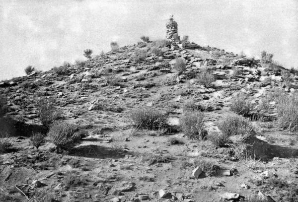
Fig. 253—Küküchomo
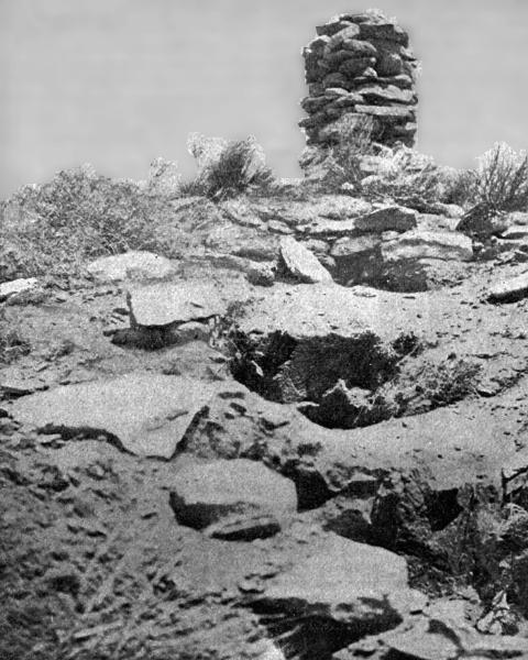
The legends concerning the ancient inhabitants of Küküchomo are conflicting. The late A. M. Stephen stated that tradition ascribes them to the Coyote and Pikya (Corn) peoples, with whom the denizens of Sikyatki made friendship, and whom the latter induced to settle there to protect them from the Walpians. He regarded them as the last arrivals of the Water-house phratry, while the Coyote people came from the north at nearly the same time. From his account it would appear that the twin mounds, Küküchomo, were abandoned before the destruction of Sikyatki. The Coyote people were, I believe, akin to the Kokop or Firewood phratry, and as the pueblo of Sikyatki was settled by the latter, it is highly probable that the inhabitants of the two villages were friendly and naturally combined against the Snake pueblo of Walpi. I believe, however, there is some doubt that any branch of the Patki people settled in Küküchomo, and the size of the town as indicated by the ruin was hardly large enough to accommodate more than one clan. Still, as there are two Küküchomo ruins, there may have been a different family in each of the two house clusters.
Fig. 254—Defensive wall on the East Mesa
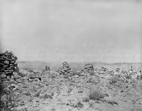
It has been said that in ancient times, before the twin mounds of Küküchomo were erected, the people of Sikyatki were greatly harassed by the young slingers and archers of Walpi, who would come across to the edge of the high cliff and assail them with impunity. Anyone, however, who contemplates the great distance from Sikyatki to the edge of the mesa may well doubt whether it was possible for the Walpi bowmen to inflict much harm in that way.
Moreover, if the word "slingers" is advisedly chosen, it introduces a kind of warfare which is not mentioned in other Tusayan legends, although apparently throwing stones at their enemies was practiced among Pueblos of other stocks in early historic times.[45]
We may suppose, however, that the survivors of both Küküchomo and Sikyatki sought refuge in Awatobi after the prehistoric destruction of their pueblos, for both were peopled by clans which came from the east, and naturally went to that village, the founders of which migrated from the same direction.
KACHINBA
The small ruin at Kachinba, the halting place of the Kachina people, seems to have escaped the attention of students of Tusayan archeology. It lies about six miles from Sikyatki, about east of Walpi, and is approached by following the trail at the foot of the same mesa upon which Küküchomo is situated. The ruin is located on a small foothill and has a few standing walls. It was evidently diminutive in size and only temporarily inhabited. The best wall found at this ruin lies at the base of the hill, where the spring formerly was. This spring is now filled in, but a circular wall of masonry indicates its great size in former times.
TUKINOBI
There are evidences that the large hill on top of East Mesa, not far from the twin mounds, was once the site of a pueblo of considerable size, but I have not been able to gather any definite legend about it. Near this ruin is the "Eagle shrine" in which round wooden imitations of eagle eggs are ceremonially deposited, and in the immediate vicinity of which is another shrine near which tracks are cut in the rock, and which were evidently considered by the Indian who pointed them out to me as having been made by some bird.[46] It is probably from these footprints, which are elsewhere numerous, that the two ruins called Küküchomo ("footprints mound") takes its name.
Jeditoh Valley Ruins
As one enters Antelope valley, following the Holbrook road, he finds himself in what was formerly a densely populated region of Tusayan. This valley in former times was regarded as a garden spot, and the plain was covered with patches of corn, beans, squashes, and chile. The former inhabitants lived in pueblos on the northern side, high up on the mesa which separates Jeditoh valley from Keam's canyon. All of these pueblos are now in ruins, and only a few Navaho and Hopi families cultivate small tracts in the once productive fields.
The majority of the series of ruins along the northern rim of Antelope valley resemble Awatobi, which is later described in detail. It is interesting to note that in the abandonment of villages the same law appears to have prevailed here as in the other Tusayan mesas, for in the shrinkage of the Hopi people they concentrated more and more to the points of the mesas. Thus, at East Mesa, Sikyatki, Kachinba, and Küküchomo were destroyed, while Walpi remained. At Middle Mesa, Chukubi and Payüpki became ruins, and in Antelope valley Awatobi was the last of the Jeditoh series to fall. There has thus been a gradual tendency to drift from readily accessible locations to the most impregnable sites, which indicates how severely the Hopi must have been harassed by their foes. It is significant that some of the oldest pueblos were originally built in the most exposed positions, and it may rightly be conjectured that the pressure on the villagers came long after these sites were chosen. The ancient or original Hopi had a sense of security when they built their first houses, and they, therefore, did not find it necessary to seek the protection of cliffs. Many of them lived in the valley of the Colorado Chiquito, others at Kishuba. As time went on, however, they were forced, as were their kindred in other pueblos, to move to inaccessible mesas guarded by vertical cliffs.
Of the several ruins of Antelope valley, that on the mesa above Jeditoh or Antelope spring is one of the largest and most interesting. Stephen calls this ruin Mishiptonga, and a plan of the old house is given by Mindeleff.
The spring called Kawaika, situated near the former village of the same name, was evidently much used by the ancient accolents of Antelope valley. From this neighborhood there was excavated a few years ago a beautiful collection of ancient mortuary pottery objects, which was purchased by Mrs Mary Hemenway, of Boston, and is now in the Peabody Museum at Cambridge. These objects have never been adequately described, although a good illustration of some of the specimens, with a brief reference thereto, was published by James Mooney[47] a few years ago.
Among the most striking objects in this collection are clay models of houses, dishes, and small vases with rims pierced with holes, and rectangular vessels ornamented with pictures of birds. There are specimens of cream, yellow, red, and white pottery in the collection which, judging by the small size of most of the specimens, was apparently votive in character.
The ruins called by Stephen "Horn-house" and "Bat-house," as well as the smaller ruin between them, have been described by Mindeleff, who has likewise published plans of the first two. From their general appearance I should judge they were not occupied for so long a time as Awatobi, and by a population considerably smaller. If all these Jeditoh pueblos were built by peoples from the Rio Grande, it is possible that those around Jeditoh spring were the first founded and that Awatobi was of later construction; but from the data at hand the relative age of the ruins of this part of Tusayan can not be determined.
There are many ruins situated on the periphery of Tusayan which are connected traditionally with the Hopi, but are not here mentioned. Of these, the so-called "Fire-house" is said to have been the home of the ancestors of Sikyatki, and Kintiel of certain Zuñi people akin to the Hopi. Both of the ruins mentioned differ in their architectural features from characteristic prehistoric Tusayan ruins, for they are circular in form, as are many of the ruins in the middle zone of the pueblo area. With these exceptions there are no circular ruins within the area over which the Hopi lay claim, and it is probable that the accolents of Kintiel were more Zuñi than Hopi in kinship.
Many ruins north of Oraibi and in the neighborhood of the farming village of Moenkopi are attributed to the Hopi by their traditionists. The ruins about Kishyuba, connected with the Kachina people, also belong to Tusayan. These and many others doubtless offer most important contributions to an exact knowledge of the prehistoric migrations of this most interesting people.
Among the many Tusayan ruins which offer good facilities for archeological work, the two which I chose for that purpose are Awatobi and Sikyatki. My reasons for this choice may briefly be stated.
Awatobi is a historic pueblo of the Hopi, which was more or less under Spanish influence between the years 1540 and 1700. When properly investigated, in the light of archeology, it ought to present a good picture of Tusayan life before the beginning of the modifications which appear in the modern villages of that isolated province. While I expected to find evidences of Spanish occupancy, I also sought facts bearing on the character of Tusayan life in the seventeenth century.
Sikyatki, however, showed us the character of Tusayan life in the fifteenth century, or the unmodified aboriginal pueblo culture of this section of the Southwest. Here we expected to find Hopi culture unmodified by Spanish influence.
The three pueblos of Sikyatki, Awatobi, and Walpi, when properly studied, will show the condition of pueblo culture in three centuries—in Sikyatki, pure, unmodified pueblo culture; in Awatobi, pueblo life as slightly modified by the Spaniards, and in Walpi, those changes resulting from the advent of Americans superadded. While special attention has thus far been given by ethnologists mainly to the last-mentioned pueblo, a study of the ruins of the other two villages is of great value in showing how the modern life developed and what part of it is due to foreign influence.
A knowledge of the inner life of the inhabitants of Tusayan as it exists today is a necessary prerequisite to the interpretation of the ancient culture of that province; but we must always bear in mind the evolution of society and the influences of foreign origin which have been exerted on it. Many, possibly the majority, of modern customs at Walpi are inherited, but others are incorporated and still others, of ancient date, have become extinct.
As much stress is laid in this memoir on the claim that objects from Sikyatki indicate a culture uninfluenced by the Spaniards, it is well to present the evidence on which this assertion is based.
(1) Hopi legends all declare that Sikyatki was destroyed before the Spaniards, called the "long-gowned" and "iron-shirted" men, came to Tusayan. (2) Sikyatki is not mentioned by name in any documentary account of Tusayan, although the other villages are named and are readily identifiable with existing pueblos. (3) No fragment of glass, metal, or other object indicative of the contact of European civilization was found anywhere in the ruin. If we add to the above the general appearance of age in the mounds and the depth of the débris which has accumulated in the rooms and over the graves, we have the main facts on which I have relied to support my belief that Sikyatki is a prehistoric ruin.
Awatobi
CHARACTERISTICS OF THE RUIN
No Tusayan ruin offers to the archeologist a better picture of the character of Hopi village life in the seventeenth century than that known as Awatobi (plate cvii).[48] It is peculiarly interesting as connecting the prehistoric culture of Sikyatki and modern Tusayan life, with which we have become well acquainted through recent research. Awatobi was one of the largest Tusayan pueblos in the middle of the sixteenth century, and continued to exist to the close of the seventeenth. It was therefore a historic pueblo. It had a mission, notices of which occur in historical documents of the period. From its preponderance in size, no less than from its position, we may suspect that it held relatively the same leadership among the other Antelope valley ruins that Walpi does today to Sichomovi and Hano.
The present condition of the ruins of Awatobi is in no respect peculiar or different from that of the remains of prehistoric structures, except that its mounds occupy a position on a mesa top commanding a wide outlook over a valley. On its east it is hemmed in by extensive sand dunes, which also stretch to the north and west, receding from the village all the way from a few hundred yards to a quarter of a mile. On the south the ruins overlook the plain, and the sands on the west separate it from a canyon in which there are several springs, some cornfields, and one or two modern Hopi houses. There is no water in the valley which stretches away from the mesa on which Awatobi is situated, and the foothills are only sparingly clothed with desert vegetation. The mounds of the ruin have numerous clumps of sibibi (Rhus trilobata), and are a favorite resort of Hopi women for the berries of this highly prized shrub. There is a solitary tree midway between the sand dunes west of the village and the western mounds, near which we found it convenient to camp. The only inhabitants of the Awatobi mesa are a Navaho family, who have appropriated, for the shade it affords, a dwarf cedar east of the old mission walls. No land is cultivated, save that in the canyons above mentioned, west of the sand hills; some fair harvests are, however, still gathered from Antelope valley by the Navaho, especially in the section higher up, near Jeditoh spring.
The ruin may be approached from the road between Holbrook and Keam's Canyon, turning to the left after climbing the mesa. This road, however, is not usually traveled, since it trends through the difficult sand hills. As Keam's Canyon is the only place in this region at which to provision an expedition, it is usual to approach Awatobi from that side, the road turning to the right shortly after one ascends the steep hill out of the canyon near Keam's trading post.
My archeological work at Awatobi began on July 6, 1895, and was continued for two weeks, being abandoned on account of the defection of my Hopi workmen, who left their work to attend the celebration of the Niman or "Farewell" katcina,[49] a July festival in which many of them participated. The ruin is conveniently situated for the best archeological results; it has a good spring near by, and is not far from Keam's Canyon, the base of supplies. The soil covering the rooms, however, is almost as hard as cement, and fragile objects, such as pottery, were often broken before their removal from the matrix. A considerable quantity of débris had to be removed before the floors were reached, and as this was firmly impacted great difficulty was encountered in successful excavations.
With a corps of trained workmen much better results than those we obtained might have been expected, and the experience which the Indians subsequently had at Sikyatki would have made my excavations at Awatobi, had they been carried on later in the season, more remunerative. While my archeological work at certain points in these interesting mounds of Awatobi was more or less superficial, it was in other places thorough, and revealed many new facts in regard to the culture of the inhabitants of this most important pueblo.
I found it inexpedient to dig in the burial places among the sand dunes, on account of the religious prejudices of my workmen. This fear they afterward overcame to a certain extent, but never completely outgrew, although the cemeteries at Sikyatki were quite thoroughly excavated, yielding some of the most striking results of the summer's exploration. The sand hills west of Sikyatki are often swept by violent gales, by which the surface is continually changing, and mortuary pottery is frequently exposed. This has always been a favorite place for the collector, and many a beautiful food bowl has been carried by the Indians from this cemetery to the trading store, for the natives do not seem to object to selling a vase or other object which they find on the surface, but rarely dig in the ground for the purpose of obtaining specimens.
NOMENCLATURE OF AWATOBI
The name Awatobi is evidently derived from awata, a bow (referring to the Bow clan, one of the strongest in the ancient pueblo), and obi, "high place of." A derivation from owa, rock, has also been suggested, but it seems hardly distinctive enough to be applicable, and is not accepted by the Hopi themselves.
While the different pueblos of Tusayan were not specially mentioned until forty years after they were first visited, the name Awatobi is readily recognized in the account of Espejo in 1583, where it is called Aguato,[50] which appears as Zaguato and Ahuato in Hakluyt.[51] In the time of Oñate (1598) the same name is written Aguatuybá.[52] Vetancurt,[53] about 1680, mentions the pueblo under the names Aguatobi and Ahuatobi, and in 1692, or twelve years after the great rebellion, Vargas visited "San Bernardo de Aguatuvi," ten leagues from Zuñi. The name appears on maps up to the middle of the eighteenth century, several years after its destruction. In more modern times various older spellings have been adopted or new ones introduced. Among these may be mentioned:
Aguatuví. Buschmann, Neu-Mexico, 231, 1858. Aguatuya. Bandelier in Journal of American Ethnology and Archæology, iii, 85, 1892 (misquoting Oñate). Aguitobi. Bandelier in Archæological Institute Papers, Am. series, iii, pt. 1, 115, 1890. Ahuatu. Bandelier, ibid., 115, 135. Ahuatuyba. Bandelier, ibid., 109. Ah-wat-tenna. Bourke, Snake Dance of the Moquis of Arizona, 195, 1884 (so called by a Tusayan Indian). Aquatasi. Walch, Charte America, 1805. Aquatubi. Davis, Spanish Conquest of New Mexico, 368, 1869. Atabi-hogandi. Bourke, op. cit., 84, 1884 (Navaho name). Aua-tu-ui. Bandelier in Archæological Institute Papers, op. cit., iv, pt. 2, 368, 1892. A-wa-te-u. Cushing in Atlantic Monthly, 367, September, 1882. Awatúbi. Bourke, op. cit., 91, 1884. Á wat u i. Cushing in Fourth Report Bureau of Ethnology, 493, 1886 (or Aguatóbi). Zagnato. Brackenridge, Early Spanish Discoveries, 19, 1857 (misprint of Hakluyt's Zaguato). Zaguate. Prince, New Mexico, 34, 1883 (misquoting Hakluyt). Zuguato. Hinton, Handbook to Arizona, 388, 1878 (misquoting Hakluyt).
The Navaho name of the ruin, as is well known, is Talla-hogan, ordinarily translated "Singing-house," and generally interpreted to refer to the mass said by the padres in the ancient church. It is probable, however, that kivas were used as chambers where songs were sung in ceremonials prior to the introduction of Christianity. Therefore why Awatobi should preeminently be designated as the "Singing-house" is not quite apparent.
The name of the mission, San Bernardino,[54] or San Bernardo, refers to its patron saint, and was first applied by Porras in honor of the natal day of this saint, on which day, in 1629, he and his companions arrived in Tusayan.
HISTORICAL KNOWLEDGE OF AWATOBI
The identification of Tusayan with the present country of the Hopi depends in great measure on the correct determination of the situation of Cibola. I have regarded as conclusive Bandelier's argument that Cibola comprised the group of pueblos inhabited by the Zuñi in the sixteenth century.[55] Regarding this as proven, Tusayan corresponds with the Hopi villages, of which Awatobi was one of the largest. It lies in the same direction and about the same distance from Zuñi as stated in Castañeda's narrative. The fact that Cardenas passed through Tusayan when he went from Cibola to the Grand Canyon in 1540 is in perfect harmony with the identification of the Hopi villages with Tusayan, and Zuñi with Cibola. Tobar, in Tusayan, heard of the great river to the west, and when he returned to the headquarters of Coronado at Cibola the general dispatched Cardenas to investigate the truth of the report. Cardenas naturally went to Tusayan where Tobar had heard the news, and from there took guides who conducted him to the Grand Canyon. Had the general been in any Hopi town at the time he sent Tobar, and later Cardenas, it is quite impossible to find any cluster of ruins which we can identify as Tusayan in the direction indicated. There can be no doubt that Tusayan was the modern Hopi country, and with this in mind the question as to which Hopi pueblo was the one first visited by Tobar is worthy of investigation.
In order to shed what light is possible on this question, I have examined the account by Castañeda, the letter of Coronado to Mendoza, and the description in the "Relacion del Suceso," but find it difficult to determine that point definitely.
In Hakluyt's translation of Coronado's letter, it is stated that the houses of the "cities" which Tobar was sent to examine were "of earth," and the "chiefe" of these towns is called "Tucano." As this letter was written before Coronado had received word from Tobar concerning his discoveries, naturally we should not expect definite information concerning the new province. Capt. Juan Jaramillo's account speaks of "Tucayan" as a province composed of seven towns, and states that the houses are terraced.
In the "Relacion del Suceso" we likewise find the province called "Tuzan" (Tusayan), and the author notes the resemblance of the villages to Cibola, but he distinctly states that the inhabitants cultivated cotton.
Castañeda's account, which is the most detailed, is that on which I have relied in my identification of Awatobi as the first Hopi pueblo seen by the Spaniards.
It seems that Don Pedro de Tobar was dispatched by Coronado to explore a province called Tusayan which was reported to be twenty-five leagues from Cibola. He had in his command seventeen horsemen and one or two foot-soldiers, and was accompanied by Friar Juan de Padilla. They arrived in the new province after dark and concealed themselves under the edge of the mesa, so near that they heard the voices of the Indians in their houses. The natives, however, discovered them at daylight drawn up in order, and came out to meet them armed with wooden clubs, bow and arrows, and carrying shields. The chief drew a line of sacred meal across the trail, and in that way symbolized that the entrance to their pueblo was closed to the intruders. During a parley, however, one of the men made a move to cross the line of meal, and an Indian struck his horse on the bridle. This opened hostilities, in which the Hopi were worsted, but apparently without loss of life. The vanquished brought presents of various kinds—cotton cloth, cornmeal, birds, skins, piñon nuts, and a few turquoises—and finding a good camping place near their pueblo, Tobar established headquarters and received homage from all the province. They allowed the Spaniards to enter their villages and traded with them.[56]
Espejo's reference to Awatobi in 1583 leaves no doubt that the pueblo was in existence in that year, and while, of course, we can not definitely say that it was not built between 1540 and 1583, the indications are that it was not. Hopi traditions assert that it was in existence when the Spaniards came, and the statement of the legendists whom I have consulted are definite that the survivors of Sikyatki went to Awatobi after the overthrow of the former pueblo. It would not appear, however, that Awatobi was founded prior to Sikyatki, nor is it stated that the refugees from Sikyatki built Awatobi, which is within the bounds of possibility, but it seems to be quite generally conceded that the Sikyatki tragedy antedated the arrival of the first Spaniards.
There can, I think, be no doubt that the Hopi pueblo first entered by Pedro de Tobar, in 1540, was Awatobi, and that the first conflict of Spanish soldiers and Hopi warriors, which occurred at that time, took place on the well-known Zuñi trail in Antelope valley, not far from Jeditoh or Antelope spring. This pueblo is the nearest village to Cibola (Zuñi), from which Tobar came, and as he took the Zuñi trail he would naturally first approach this village, even if the other pueblos on the rim of this valley were inhabited. It is interesting to consider a few lines from Castañeda, describing the event of that episode, to see how closely the site of Awatobi conforms to the narrative. In Castañeda's account of Tobar's visit we find that the latter with his command entered Tusayan so secretly that their presence was unknown to the inhabitants, and they traversed a cultivated plain without being seen, so that, we are told, they approached the village near enough to hear the voices of the Indians without being discovered. Moreover, the Indians, the narrative says, had a habit of descending to their cultivated fields, which implies that they lived on a mesa top. Awatobi was situated on a mesa, and the cultivated fields were in exactly the position indicated. The habit of retiring to their pueblo at night is still observed, or was to within a few years. Tobar arrived at the edge of Antelope valley after dark (otherwise he would have been discovered), crossed the cultivated fields under cover of night, and camped under the town at the base of the mesa. The soldiers from that point could readily hear the voices of the villagers above them. Even at the base of the lofty East Mesa I have often heard the Walpi people talking, while the words of the town crier are intelligible far out on the plain. From the configuration of the valley it would not, however, have been easier for Awatobians to have seen the approaching Spaniards than for the Walpians; still it was possible for the invaders to conceal their approach to Walpi in the same way. If, however, the first pueblo approached was Walpi, and Tobar followed the Zuñi trail, I think he would have been discovered by the Awatobi people before nightfall if he entered the cultivated fields early in the evening. It would be incredible to believe that he wandered from the trail; much more likely he went directly to Awatobi, the first village en route, and then encamped until the approach of day before entering the pueblo. At sunrise the inhabitants, early stirring, detected the presence of the intruders, and the warriors went down the mesa to meet them. They had already heard from Cibola of the strange beings, men mounted on animals which were said to devour enemies.
It may seem strange that the departure of an expedition against Tusayan was unknown to the Hopi, but the narrative leads us to believe that such was the fact. The warriors descended to the plain, and their chief drew a line of sacred meal across the trail to symbolize that the way to their pueblo was closed; whoever crossed it was an enemy, and punishment should be meted out to him. This custom is still preserved in several ceremonials at the present day, as, for instance, in the New-fire rites[57] in November and in the Flute observance in July.[58] The priests say that in former times whoever crossed a line of meal drawn on the trail at that festival was killed, and even now they insist that no one is allowed to pass a closed trail. The Awatobi warriors probably warned Tobar and his comrades not to advance, but the symbolic barrier was not understood by them. The Spaniards were not there to parley long, and it is probable that their purpose was to engage in a quarrel with the Indians. Urged on by the priest, Juan de Padilla, "who had been a soldier in his youth," they charged the Indians and overthrew a number, driving the others before them. The immediate provocation for this, according to the historian, was that an Indian struck one of the horses on the bridle, at which the holy father, losing patience, exclaimed to his captain, "Why are we here?" which was interpreted as a sign for the assault.
It must, however, be confessed that if the pueblo of Walpi was the first discovered an approach by stealth without being seen would have been easier for Tobar if the village referred to was Walpi then situated on the Ash-hill terrace, with the East Mesa between it and the Zuñi trail. To offset this probability, however, is the fact that the Zuñi trail now runs through Awatobi, or in full view of it and there is hardly a possibility that Tobar left that trail to avoid Awatobi. He would naturally visit the first village, and not go out of his way seven miles beyond it, seeking a more distant pueblo.
The effect of this onslaught on men armed with spears, clubs, and leather shields can be imagined, and the encounter seems to have discouraged the Awatobi warriors from renewed resistance. They fled, but shortly afterward brought presents as a sign of submission, when Tobar called off his men. Thus was the entry of the Spaniards into Tusayan marked with bloodshed for a trifling offense. Shortly afterward Tobar entered the village and received the complete submission of the people.
The names of the Tusayan pueblos visited by Tobar in this first entrance are nowhere mentioned in the several accounts which have come down to us. Forty years later, however, the Spaniards returned and found the friendly feeling of Awatobi to the visitors had not lapsed. When Espejo approached the town in 1583, over the same Zuñi trail, the multitudes with their caciques met him with great joy and poured maize (sacred meal?) on the ground for the horses to walk upon. This was symbolic of welcome; they "made" the trail, a ceremony which is still kept up when entrance to the pueblo is formally offered.[59]
The people, considering their poverty, were generous, and gave Espejo "hand towels with tassels" at the corners. These were probably dance kilts and ceremonial blankets, which then, as now, the Hopi made of cotton.
The pueblo, called "Aguato" in the account of that visit, was without doubt Awatobi. The name Aguatuybá, mentioned by Oñate, is also doubtless the same, although, as pointed out to me by Mr Hodge, "through an error probably of the copyist or printer, the name Aguatuybá is inadvertently given by Oñate among his list of Hopi chiefs, while Esperiez is mentioned among the pueblos." In Oñate's list we recognize Oraibi in "Naybi," and Shuñopovi in "Xumupamí" and "Comupaví," the most westerly town of the Middle Mesa. "Cuanrabi" and "Esperiez" are not recognizable as pueblos.
Espejo, therefore, appears to have been the first to mention Awatobi as "Aguato," which is metamorphosed in Hakluyt into "Zaguato or "Ahuzto,"[60] although evidently Oñate's "Aguatuybá" was intended as a name of a pueblo.
I have not been able to determine satisfactorily the date of the erection of the mission building of San Bernardino at Awatobi, but the name is mentioned as early as 1629. In that year three friars went to Tusayan and began active efforts to convert the Hopi.[61]
It is recorded[62] that Padre Porras, with Andres Gutierrez, Cristoval de la Concepcion, and ten soldiers, arrived in Tusayan, "dia del glorioso San Bernardo (que és el apellido que aora tiene aquel pueblo)," which leaves no doubt why the mission at Awatobi was so named. Although an apostate Indian had spread the report, previously to the advent of these priests in Tusayan, that the Spaniards were coming among them to burn their pueblos, rob their homes, and devour[63] their children, the zealous missionaries in 1629 converted many of the chiefs and baptized their children. The cacique, Don Augustin, who appears to have been baptized at Awatobi, apparently lived in Walpi or at the Middle Mesa, and returning to his pueblo, prepared the way for a continuation of the apostolic work in the villages of the other mesas.
But the missionary labors of Porras came to an untimely end. It is written that by 1633 he had made great progress in converting the Hopi, but in that year, probably at Awatobi, he was poisoned. Of the fate of his two companions and the success of their work little is known, but it is recorded that the succession of padres was not broken up to the great rebellion in 1680. Figueroa, who was massacred at Awatobi in that year, went to Tusayan in 1674 with Aug. Sta. Marie. Between the death of Porras and the arrival of Figueroa there was an interval of eleven years, during which time the two comrades of Porras or Espeleta, who went to Tusayan in 1650, took charge of the spiritual welfare of the Hopi. Espeleta and Aug. Sta. Marie were killed in 1680 at San Francisco de Oraibi and Walpi, respectively, and José Trujillo probably lost his life at Old Shuñopovi at the same time. As there is no good reason to suppose that Awatobi, one of the most populous Tusayan pueblos, was neglected by the Spanish missionaries after the death of Porras in 1633, and as it was the first pueblo encountered on the trail from Zuñi, doubtless San Bernardino was one of the earliest missions erected in Tusayan. From 1680 until 1692, the period of independence resulting from the great Pueblo revolt, there was no priest in Tusayan, nor, indeed, in all New Mexico. Possibly the mission was repaired between 1692 and 1700, but it is probable that it was built as early as the time Porras lived in Awatobi. It is explicitly stated that in the destruction of Awatobi in 1700 no missionaries were killed, although it is recorded that early in that year Padre Garaycoechea made it a visit.
The disputes between the Jesuits and Franciscans to obtain the Hopi field for missionary work during the eighteenth century naturally falls in another chapter of Spanish-Tusayan history. Aside from sporadic visits to the pueblos, nothing tangible appears to have resulted from the attempts at conversion in this epoch. True, many apostates were induced to return to their old homes on the Rio Grande and some of the Hopi frequently asked for resident priests, making plausible offers to protect them; but the people as a whole were hostile, and the mission churches were never rebuilt, nor did the fathers again live in this isolated province.
In 1692 Awatobi was visited by Don Diego de Vargas, the reconquerer of New Mexico, who appears to have had no difficulty bringing to terms the pueblos of Awatobi, Walpi, Mishoñinovi, and Shuñopovi.[64] He found, however, that Awatobi was "fortified," and the entrance so narrow that but one man could enter at a time. The description leads us to conclude that the fortification was the wall at the eastern end, and the entrance the gateway, the sides of which are still to be seen. The plaza in which the cross was erected was probably just north of the walls of the mission.
There would seem to be no doubt that a mission building was standing at Awatobi before 1680, for Vetancurt, writing about the year named, states that in the uprising it was burned.[65] At the time of the visit of Garaycoechea, in the spring of 1700, he found that the mission had been rebuilt. In this connection it is instructive, as bearing on the probable cause of the destruction of Awatobi, to find that while the inhabitants of this pueblo desired to have the mission rehabilitated, the other Tusayan pueblos were so hostile that the friends of the priest in Awatobi persuaded him not to attempt to visit the other villages. This warning was no doubt well advised, and the tragic fate which befell Awatobi before the close of the year shows that the trouble was brewing when the padre was there, and possibly Garaycoechea's visit hastened the catastrophe or intensified the hatred of the other pueblos.
At the time of Garaycoechea's visit he baptized, it is said, 73 persons. This rite was particularly obnoxious[66] to the Hopi, as indeed to the other Pueblo Indians, notwithstanding they performed practically the same ceremony in initiations into their own secret societies. The Awatobians, however, or at least some of them, allowed this rite of the Christians, thus intensifying the hatred of the more conservative of their own village and of the neighboring pueblos. These and other facts seem to indicate that the real cause of the destruction of Awatobi was the reception of Christianity by its inhabitants, which the other villagers regarded as sorcery. The conservative party, led by Tapolo, opened the gate of the town to the warriors of Walpi and Mishoñinovi, who slaughtered the liberals, thus effectually rooting out the new faith from Tusayan, for after that time it never again obtained a foothold.
The visit of Padre Juan Garaycoechea to Tusayan was at the invitation of Espeleta, chief of Oraibi, but he went no farther than Awatobi, where he baptized the 73 Hopi. He then returned to the "governor," and arrived at Zuñi in June. According to Bancroft (p. 222), "In the 'Moqui Noticias' ms., 669, it is stated that the other Moquis, angry that Aguatuvi had received the padres, came and attacked the pueblo, killed all the men, and carried off all the women and children, leaving the place for many years deserted." Although I have not been able to consult the document quoted, this conclusion corresponds so closely with Hopi tradition that I believe it is practically true, although Bancroft unfortunately closes the quotation I have made from his account with the words, "I think this must be an error." Espeleta, the Oraibi chief, and 20 companions were in Santa Fé in October, 1700, and proposed a peace in which the Hopi asked for religious toleration, which Governor Cubero refused. As a final appeal he desired that the fathers should not permanently reside with them, but should visit one pueblo each year for six years; but this request was also rejected. Espeleta returned to Oraibi, and immediately on his appearance an unsuccessful attempt was made to destroy Awatobi, followed, as recounted in the legend, by a union with Walpi and Mishoñinovi, by which the liberal-minded villagers of the Antelope mesa were overthrown. Documentary and legendary accounts are thus in strict accord regarding the cause of the destruction.
The meager fragmentary historical evidence that can be adduced shows that the destruction of Awatobi occurred in the autumn or early winter of 1700. In May of that year we have the account of the visiting padre, and in the summer when Espeleta was at Santa Fé, the pueblo was flourishing. The month of November would have been a favorable one for the destruction of the town for the reason that during this time the warriors would all be engaged in secret kiva rites. The legend relates that the overthrow of the pueblo was at the Naacnaiya,[67] which now takes place in November.
For many years after its destruction the name of Awatobi was still retained on maps including the Tusayan province, and there exist several published references to the place as if still inhabited; but these appear to be compilations, as no traveler visited the site subsequently to 1700. It is never referred to in writings of the eighteenth or first half of the nineteenth centuries, and its site attracted no attention. The ruins remained unidentified until about 1884, when the late Captain J. G. Bourke published his book on the "Snake Dance of the Moquis," in which he showed that the ruin called by the Navaho Tally-hogan was the old Awatobi which played such a prominent part in early Tusayan history.
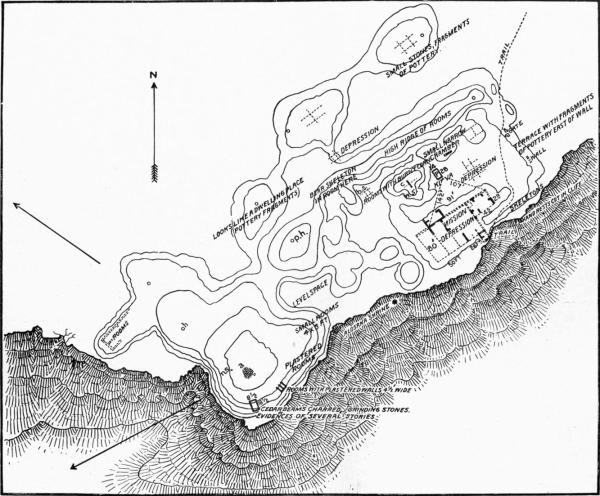
The ruin was described and figured a few years later by Mr Victor Mindeleff in his valuable memoir on Cibola and Tusayan architecture. Bourke's reference is very brief and Mindeleff's plan deficient, as it includes only a portion of the ruin, namely, the conspicuous mission walls and adjacent buildings, overlooking entirely the older or western mounds, which are the most characteristic. In 1892 I published the first complete ground-plan of the ruins of Awatobi, including both eastern and western sections. As Mindeleff's plan is defective, his characterization of the architectural features of the pueblo is consequently faulty. He says: "The plan suggests that the original pueblo was built about three sides of a rectangular court, the fourth or southeast side, later occupied by the mission buildings, being left open or protected by a low wall." While the eastern portion undoubtedly supports this conclusion, had he examined the western or main section he would doubtless have qualified his conclusion (plate cvii). This portion was compact, without a rectangular court, and was of pyramidal form. The eastern section was probably of later construction, and the mission was originally built outside the main pueblo, although probably a row of rooms of very ancient date extended along the northern side opposite the church. As it was customary in Tusayan to isolate the kivas, these rooms in Awatobi were probably extramural and may have been situated in this eastern court, but the majority of the people lived in the western section. The architecture of the mission and adjacent rooms shows well-marked Spanish influence, which is wholly absent in the buildings forming the western mounds.
BUREAU OF AMERICAN ETHNOLOGY—— SEVENTEENTH ANNUAL REPORT PL. CVII GROUND PLAN OF AWATOBI
LEGEND OF THE DESTRUCTION OF AWATOBI
The legend of the overthrow of Awatobi is preserved in detail among the living villagers of Tusayan, and like all stories which have been transmitted for several generations exist in several variants, differing in episodes, but coinciding in general outlines. In the absence of contemporary documentary history, which some time may possibly be brought to light, the legends are the only available data regarding an event of great importance in the modern history of Tusayan.
I have obtained the legends from Supela, Shimo,[68] Masiumptiwa, and Saliko, and the most complete appears to be that of the last mentioned. The others dilated more on the atrocities which were committed on the bodies of the unfortunate captives, and the tortures endured before they were killed. All show traces of modification, incorporation, and modern invention.
Destruction of Awatobi as related by Saliko[69]
"The chiefs Wiki and Shimo, and others, have told you their stories, and surely their ancestors were living here at Walpi when Awatobi was occupied. It was a large village, and many people lived there, and the village chief was called Tapolo, but he was not at peace with his people, and there were quarreling and trouble. Owing to this conflict only a little rain fell, but the land was fertile and fair harvests were still gathered. The Awatobi men were bad (powako, sorcerers). Sometimes they went in small bands among the fields of the other villagers and cudgeled any solitary worker they found. If they overtook any woman they ravished her, and they waylaid hunting parties, taking the game, after beating and sometimes killing the hunters. There was considerable trouble in Awatobi, and Tapolo sent to the Oraibi chief asking him to bring his people and kill the evil Awatobians. The Oraibi came and fought with them, and many were killed on both sides, but the Oraibi were not strong enough to enter the village, and were compelled to withdraw. On his way back the Oraibi chief stopped at Walpi and talked with the chiefs there. Said he, 'I can not tell why Tapolo wants the Oraibi to kill his folks, but we have tried and have not succeeded very well. Even if we did succeed, what benefit would come to us who live too far away to occupy the land? You Walpi people live close to them and have suffered most at their hands; it is for you to try.' While they were talking Tapolo had also come, and it was then decided that other chiefs of all the villages should convene at Walpi to consult. Couriers were sent out, and when all the chiefs had arrived Tapolo declared that his people had become sorcerers (Christians), and hence should all be destroyed.
"It was then arranged that in four days large bands from all the other villages should prepare themselves, and assemble at a spring not far from Awatobi. A long while before this, when the Spaniards lived there, they had built a wall on the side of the village that needed protection, and in this wall was a great, strong door. Tapolo proposed that the assailants should come before dawn, and he would be at this door ready to admit them, and under this compact he returned to his village. During the fourth night after this, as agreed upon, the various bands assembled at the deep gulch spring, and every man carried, besides his weapons, a cedar-bark torch and a bundle of greasewood. Just before dawn they moved silently up to the mesa summit, and, going directly to the east side of the village, they entered the gate, which opened as they approached. In one of the courts was a large kiva, and in it were a number of men engaged in sorcerer's rites. The assailants at once made for the kiva, and plucking up the ladder, they stood around the hatchway, shooting arrows down among the entrapped occupants. In the numerous cooking pits fire had been maintained through the night for the preparation of food for a feast on the appointed morning, and from these they lighted their torches. Great numbers of these and the bundles of greasewood being set on fire, they were cast down the hatchway, and firewood from stacks upon the house terraces were also thrown into the kiva. The red peppers for which Awatobi was famous were hanging in thick clusters along the fronts of the houses, and these they crushed in their hands and flung upon the blazing fire in the kiva to further torment their burning occupants. After this, all who were capable of moving were compelled to travel or drag themselves until they came to the sand-hills of Mishoñinovi, and there the final disposition of the prisoners was made.
"My maternal ancestor had recognized a woman chief (Mamzrau moñwi), and saved her at the place of massacre called Maski, and now he asked her whether she would be willing to initiate the woman of Walpi in the rites of the Mamzrau. She complied, and thus the observance of the ceremonial called the Mamzráuti came to Walpi. I can not tell how it came to the other villages. This Mamzrau-moñwi had no children, and hence my maternal ancestor's sister became chief, and her tiponi (badge of office) came to me. Some of the other Awatobi women knew how to bring rain, and such of them as were willing to teach their songs were spared and went to different villages. The Oraibi chief saved a man who knew how to cause peaches to grow, and that is why Oraibi has such an abundance of peaches now. The Mishoñinovi chief saved a prisoner who knew how to make the sweet, small-ear corn grow, and that is why it is more abundant there than elsewhere. All the women who knew song prayers and were willing to teach them were spared, and no children were designedly killed, but were divided among the villages, most of them going to Mishoñinovi. The remainder of the prisoners, men and women, were again tortured and dismembered and left to die on the sand hills, and there their bones are, and that is the reason the place is called Maschomo (Death-mound). This is the story of Awatobi told by my old people."
All variants of the legend are in harmony in this particular, that Awatobi was destroyed by the other Tusayan pueblos, and that Mishoñinovi, Walpi, and probably Oraibi and Shuñopovi participated in the deed. A grievance that would unite the other villagers against Awatobi must have been a great one, indeed, and not a mere dispute about water or lands. The more I study the real cause, hidden in the term powako, "wizard" or "sorcerer," the more I am convinced that the progress Christianity was making in Awatobi, after the reconquest of the Pueblos in 1692, explains the hostility of the other villagers. The party favoring the Catholic fathers in Awatobi was increasing, and the other Tusayan pueblos watched its growth with alarm. They foresaw that it heralded the return of the hated domination of the priests, associated in their minds with practical slavery, and they decided on the tragedy, which was carried out with all the savagery of which their natures were capable.
They greatly feared the return of the Spanish soldiers, as the epoch of Spanish rule, mild though it may have been, was held in universal detestation. Moreover, after the reconquest of the Rio Grande pueblos, many apostates fled to Tusayan and fanned the fires of hatred against the priests. Walpi received these malcontents, who came in numbers a few years later. Among these arrivals were Tanoan warriors and their families, part of whom were ancestors of the present inhabitants of Hano.
It was no doubt hoped that the destruction of Awatobi would effectually root out the growing Christian influence, which it in fact did; and for fifty years afterward Tusayan successfully resisted all efforts to convert it. Franciscans from the east and Jesuits from the Gila in the south strove to get a new hold, but they never succeeded in rebuilding the missions in this isolated province, which was generally regarded as independent.
From the scanty data I have been able to collect from historical and legendary sources, it seems probable that Awatobi was always more affected by the padres than were the other Tusayan pueblos. This was the village which was said to have been "converted" by Padre Porras, whose work, after his death by poison in 1633, was no doubt continued by his associates and successors. About 1680, as we learn from documentary accounts, the population of Awatobi was 800,[70] and it was probably not much smaller in 1700, the time of its destruction.
EVIDENCES OF FIRE IN THE DESTRUCTION
Wherever excavations were conducted in the eastern section of Awatobi, we could not penetrate far below the surface without encountering unmistakable evidences of a great conflagration. The effect of the fire was particularly disastrous in the rooms of the eastern section, or that part of the pueblo contiguous to the mission. Hardly a single object was removed from this part of Awatobi that had not been charred. Many of the beams were completely burned; others were charred only on their surfaces. The rooms were filled with ashes and scoriæ, while the walls had been cracked as if by intense heat.
Perhaps the most significant fact in regard to the burning of Awatobi was seen in some of the houses where the fire seems to have been less intense. In many chambers of the eastern section, which evidently were used as granaries, the corn was stacked in piles just as it is today under many of the living rooms at Walpi, a fact which tends to show that there was no attempt to pillage the pueblo before its destruction. The ears of corn in these store-rooms were simply charred, but so well preserved that entire ears of maize were collected in great numbers. It may here be mentioned that upon one of the stacks of corn I found during my excavations for the Hemenway Expedition in 1892, a rusty iron knife-blade, showing that the owner of the room was acquainted with objects of Spanish manufacture. This blade is now deposited with the Hemenway collection in the Peabody Museum at Cambridge.
THE RUINS OF THE MISSION
The mission church of San Bernardino de Awatobi was erected very early in the history of the Spanish occupancy, and its ruined walls are the only ones now standing above the surface. This building was constructed by the padres on a mesa top, while the churches at Walpi and Shuñopovi were built in the foothills near those pueblos. The mission at Oraibi likewise stood on a mesa top, so that we must qualify Mindeleff's statement[71] that "at Tusayan there is no evidence that a church or mission house ever formed part of the villages on the mesa summits.... These summits have been extensively occupied only in comparatively recent time, although one or more churches may have been built here at an early date as outlooks over the fields in the valley below."
At the time of the Spanish invasion three of the Hopi villages stood on the foothills or lower terraces of the mesas on which they now stand, and the other two, Awatobi and Oraibi, occupied the same sites as today, on the summits of the mesas.
BUREAU OF AMERICAN ETHNOLOGY—— SEVENTEENTH ANNUAL REPORT PL. CVIII RUINS OF SAN BERNARDINO DE AWATOBI
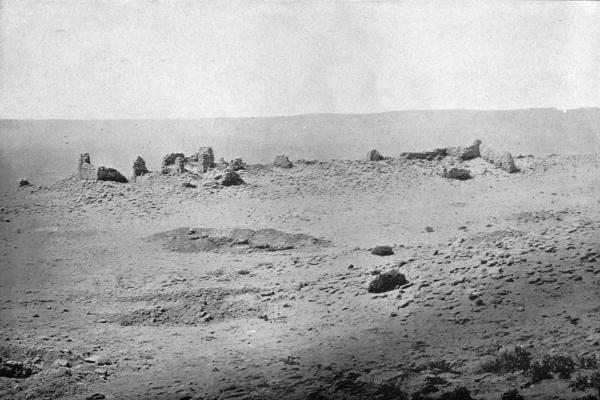
I believe that at the time of the Spanish discovery of Tusayan by Pedro de Tobar in 1540, there were only five Tusayan towns—Walpi, Awatobi, Shuñopovi, Mishoñinovi, and Oraibi. Later, Awatobi was destroyed, and shortly after 1680 Walpi, the only East Mesa town, together with Mishoñinovi and Shuñopovi, on the Middle Mesa, were moved to the elevated sites they now occupy. Oraibi, therefore, is probably the only Tusayan pueblo, at present inhabited, which occupies practically the same site that it did in 1540.
In their excavations for the foundations of new houses the present inhabitants of Oraibi often find, as I am informed by Mr H. R. Voth, the missionary at that place, vessels or potsherds of ancient Tusayan ware closely resembling that which is found in the ruins of Sikyatki and Awatobi.
The mission building at Awatobi, known in the church history of New Mexico and Arizona as San Bernardo or San Bernardino, was reputed to be the largest in Tusayan, and its walls are still the best preserved of any mission structure in that province. This, however, does not imply that the church structures of Tusayan are well preserved, for the mission buildings at Walpi have wholly disappeared, while at Oraibi little more than a pile of stones remains. Of the Shuñopovi mission of San Bernabe there are no standing walls save at one end, which are now used as a sheep corral.
The mission of San Bernardino de Awatobi was built on the southern side of the eastern part of the pueblo on the edge of the cliff, and its walls are the only ones of Awatobi now standing above ground. From the situation of these walls, as compared with the oldest part of Awatobi—the western mounds—I believe that San Bernardino mission was, when erected, beyond the limits of the pueblo proper—a custom almost universally followed in erecting pueblo mission churches—necessary in this instance, since from the compactness of the village there was no other available site. The same was true of the missions of Oraibi and Shuñopovi, and probably of Old Walpi. As time passed additional buildings were erected near it, this eastward extension altering the original plan of the town, but in no way affecting the configuration of the older portion.
From its commanding position on the edge of the mesa the mission walls must have presented an imposing appearance from the plain below, rising as they did almost continuously with the side of the cliff, making a conspicuous structure for miles across Antelope valley, from which its crumbling walls are still visible (plate cviii).
When compared with the masonry of unmodified pueblo ruins the walls of the mission may be designated massive, and excavation at their foundations was very difficult on account of the great amount of débris which had fallen about them. With the limited force of laborers at my command the excavations could not be conducted with a great degree of thoroughness.
In the middle of what I supposed to have been the main church there was much sand, evidently drift, and in it I sank a trench 10 feet below the surface without reaching anything which I considered a floor. We found in excavations at the foundation of the church walls fragments of glass, several copper nails, a much-corroded iron hook, a copper bell pivot, and fragments of Spanish pottery. From the character of these objects alone there is no doubt in my mind of the former existence of Spanish influence, and the method of construction of the mission walls and the addition constructed of adobe containing chopped straw, substantiate this conclusion. Supposing, from the architecture and orientation of other New Mexican missions, that the altar was at the western end, opposite the entrance to the church, I sank a trench along the foundation of the wall on that side, but encountered such a mass of fallen stone at that point that I found it impossible to make much progress, and the fact that the floor was more than 10 feet below the surface of the central depression led me to abandon, as impossible with my little band of native excavators, the laying bare of the floor of the church.
Fig. 255—Ground plan of San Bernardino de Awatobi
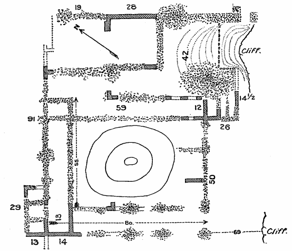
The ground plan (figure 255) of the mission resembles that of the Zuñi church, and is not unlike the plans of the churches in the Rio Grande pueblos. The tall buttresses, which rise 15 or 20 feet above the trail up the mesa on the southern corner, are, I believe, remnants of towers which formerly supported a balcony. During a previous visit to Tusayan I obtained fragments[72] of the ancient bell, which are now on exhibition in the Hemenway section of the Peabody Museum at Cambridge.
The stone walls of the mission were rarely dressed or carefully fitted, the interstices being filled in with loose rubble laid in adobe. There was apparently a gallery over the entrance to the building overlooking many smaller buildings, which evidently were the quarters of the resident priest. The construction of the walls was apparently a laborious task, as many of the stones are large and must have been brought a considerable distance. These stones were laid in adobe, and apparently were plastered without and within, although little evidence of the former plastering may now be seen. At the northwestern corner, however, there still remain well-made adobe walls, the clay having been intermixed with straw. From the general appearance of these walls I regard them as of late construction, probably long after the destruction of the mission.
An examination of the plan of the mission building shows that it was oriented about north and south, with the entrance toward the latter direction. Compared with many other pueblo missions, this would seem to be an exceptional position. In my excavations I naturally sought the probable position of the entrance and, opposite it, the recess for the altar. It is evident, from the form of the standing walls, that an entrance from the east would be blocked by standing walls, and the axis of the building is north and south. The theory that the door was at the south has much in its favor, but there are several almost fatal objections to this conclusion.
If, however, we suppose that the entrance was in the south wall, the high walls still standing above the trail up the mesa would then recall the façades of other missions. The rooms east of the largest inclosure, by this interpretation, would be outbuildings—residence rooms for the padres—one side of which forms the eastern walls of the church edifice. The form of the Awatobi church, as indicated by the walls still standing, is very similar to that of Zuñi, notwithstanding the orientation appears to be somewhat different.
Excavations failed to reveal any sign of the altar recess at either the northern or the western end, which is not surprising, since the walls are so poorly preserved in both these directions. It was, moreover, very difficult to make a satisfactory examination of the foundations of the walls at any point on account of the fallen stories, which encumbered the floor at their bases.
From the appearance of antiquity it seems probable that long before the mission buildings were erected a ridge of many-storied houses extended eastward from the pueblo on the northern side of a level space or court, in which there were, either then or later, ceremonial chambers or kivas. The southern side of this open space was the site of the mission, but was then unoccupied. This open space recalls the large court at Walpi, where the Snake dance occurs, but it was considerably broader, one side being formed by the structures which rose from the edge of the mesa. In course of time, however, the mission buildings were erected on this site, and a wall connecting the ridge of houses on the north and the outhouses of the mission was made, thus inclosing the court on all four sides. It was into this inclosure, through a gateway, the buttresses of which still remain, that the assailants passed on that eventful night when Awatobi was destroyed.
There is good evidence that a massacre of Awatobians occurred in the southeastern angle of the eastern part of the pueblo, just east of the mission. If so, it is probable that many of the unfortunates sought refuge in the outbuildings of the church. Suspecting that such was the case, I excavated a considerable space of ground at these places and found many human skulls and other bones thrown together in confusion. The earth was literally filled with bones, evidently hastily placed there or left where the dead fell. These bodies were not buried with pious care, for there were no fragments of mortuary pottery or other indication of burial objects. Many of the skulls were broken, some pierced with sharp implements. While it is true that possibly this may have been a potter's field, or, from its position east of the mission, a Christian burial place, as at Zuñi, the evidence from the appearance of the bodies points to a different conclusion. According to the legends, the hostiles entered the pueblo through the adjacent gateway; their anger led them especially against those of the inhabitants who were regarded as powako or sorcerers, and their first acts of violence would naturally have been toward those who sought refuge in the buildings adjacent the church. Near this hated "Singing-house" the slaughter began, soon extending to the kivas and the whole of the eastern section of the village. There was no evidence of murderous deeds in the rooms of the western section of the old pueblo, and the legends agree in relating that most of the men were in kivas, not far from the mission, when the village was overthrown. There is no legendary evidence that there were any Spanish priests in the mission at the time of its destruction, and there is no record extant of any Spaniards losing their lives at Awatobi at the time of its destruction, although the fact of the occurrence, according to Bandelier,[73] was recorded.
The traditional clans which inhabited Awatobi were the Awata (Bow), Honani (Badger), Piba (Tobacco), and Buli (Butterfly). The Bow people appear to have been the most important of these, since their name was applied to the village. Their totemic signatures, in pictographic form, may still be seen on the sides of the cliff under Awatobi, and in the ruins was found a fine arrowshaft polisher on which was an incised drawing of a bow and an arrow, suggesting that the owner was a member of the Bow phratry. Saliko, the chief of the woman's society known as the Mamzrautû, insists that this priesthood was strong in the fated pueblo, and that a knowledge of its mysteries was brought to Walpi by one of the women who was saved.
It is claimed by the folklorists of the Tataukyamû, a priesthood which, controls the New-fire ceremonies at Walpi, and is prominent in the Soyaluña, or the rites of the winter solstice, that the Piba or Tobacco phratry brought the fetishes of that society to Walpi, and there are many obscurely known resemblances between the Mamzrauti and the Wüwütcimti celebrations in Walpi which appear to support that claim. The Piba phratry is likewise said to have come to Walpi comparatively late in the history of the village, which fact points the same way.
Undoubtedly Awatobi received additions to its population from the south when the pueblos on the Little Colorado were abandoned, and there are obscure legends which support that belief; but the largest numbers were recruited from the pueblos in the eastern section of the country.[74]
THE KIVAS OF AWATOBI
A pueblo of the size of Awatobi, with so many evidences of long occupancy, would no doubt have several ceremonial chambers or kivas, but as yet no one has definitely indicated their positions. I have already called attention to evidences that if they existed they were probably to be looked for in the open court east of the western mounds and in the space north of the mission. In all the inhabited Tusayan pueblos the kivas are separated from the house clusters and are surrounded by courts or dance plazas. No open spaces existed in the main or western mounds of Awatobi, and there was no place there for kivas unless the pueblo was exceptional in having such structures built among the dwellings, as at Zuñi. A tradition has survived that Awatobi had regular kivas, partially subterranean, of rectangular shape, and that they were situated in open courts. This would indicate that the space east of the oldest part of the ruin may have been the sites of these chambers. The old priests whom I have consulted in regard to the probable positions of Awatobi kivas have invariably pointed out the mounds north of the mission walls in the eastern section of the ruin as the location of the kivas, and in 1892 I proved to my satisfaction that these directions were correct.
There is no reason to suppose that the kiva was a necessity in the ancient performance of the Tusayan ritual, and there are still performed many ceremonials as secret and as sacred as any others which occur in rooms used as dwellings or for the storage of corn. Thus, the Flute ceremony, one of the most complicated in Tusayan, is not, and according to legends never was, performed in a kiva. On the contrary, the secret rites of the Flute society are performed in the ancestral Flute chamber or home of the oldest woman of the Flute clan. Originally, I believe, the same was true in the case of other ceremonials, and that the kiva was of comparatively recent introduction into Tusayan.[75]
Speaking of the sacred rooms of Awatobi, Mindeleff says: "No traces of kivas were visible at the time the ruin was surveyed," but Stephen is quoted in a legend that "the people of Walpi had partly cleaned out one of these chambers and used it as a depository for ceremonial plume-sticks, but the Navaho carried off their sacred deposits, tempted probably by their market value as ethnologic specimens." It is true that while from a superficial examination of the Awatobi mounds the position of the kivas is difficult to locate, a little excavation brings their walls to light. It is likewise quite probable that the legend reported by Stephen has a basis in fact, and that the people at Walpi may have used old shrines in Awatobi, after its destruction, as the priests of Mishoñinovi do at the present time; but I very much doubt if the Navaho sold any of the sacred prayer emblems from these fanes. It is hardly characteristic of these people to barter such objects among one another, and no specimens from the shrines appear to have made their way into the numerous collections of traders known to me. There is, however, archeological evidence revealed by excavations that the room centrally placed in the court north of the mission contained a shrine in its floor on the night Awatobi fell.