CHAP. V. PROVINCE OF RIO GRANDE DO SUL.
Reading edition
Colonization—Boundaries—Climate—Aspect and Productions—Contests between Spaniards and Portuguese—Divisionary Line between these two Powers—Opposition by the Indians of the Seven Missions—Their Defeat—Revived Contests between Spaniards and Portuguese—Mountains—Rivers—Lakes—Capes and Ports—Islands—Mineralogy—Phytology—Zoology—Large Fazendas for breeding Cattle—Mode of Management—Sheep-Flocks—Use of the Laço and Balls—Towns, Nature of Exports, Villages, &c. including those of the District of Monte Video.
This province, which includes the major part of the territory to the south of the capitania of St. Amaro, either had no donatories when John III. divided the coast, or from some other cause it was not colonized. Neither was its colonization accomplished by Viscount D’Asseca, nor his brother, John Correa de Sa, at the period of the great distributions of land which Peter II. granted to them in the territory denominated St. Gabriel, adjacent to the river Plate.
The names by which this capitania was sometimes, although seldom, designated, of D’El Rey and St. Pedro, are supposed to have been given when it was first annexed to the crown lands.
About the end of the sixteenth or the beginning of the seventeenth century, some Vincentistas removed their establishments to the vicinity of lake Dos Patos, and their descendants extended themselves to the south and west, as the Indians gradually relinquished the country.
The capitanias of the brothers Souzas, could not be enlarged beyond their prescribed limits, although the adjoining districts of land were devoluta, or without donatories; yet the first settlers there from these capitanias were always considered their people, and known as Vincentistas and Paulistas, until those districts were erected into this province. It is the most southern one in the Brazil, very extensive and important, lying between twenty-eight and thirty-five degrees of south latitude, and is bounded on the north by the province of St. Catharina (from which it is separated by the river Manbituba) and the province of St. Paulo; on the west it is skirted by the river Uruguay and the province of that name; on the south by the river Plate; and on the east by the Atlantic Ocean; being upwards of five hundred miles long and four hundred wide.
The climate is temperate, participating almost equally of heat and cold, and the air is pure and healthy. Winter begins in May and lasts till October. The prevailing wind is from the south-east. The longest day of the year, in the most southern part of the province, is about fourteen hours, or rather more. Frost occasionally prevails from the month of July till September. The greatest part of this province is flat, having extensive plains, watered with numerous torrents, or rapid streams, and with lakes. No other district possesses such abundant pastures. In its southern parts the soil is well adapted to a profitable diversity of productions; to wheat, rye, barley, Indian corn, rice, peas, beans, water-melons, melons, onions, as well as to all that arises from Spanish horticulture; also, some cotton, mandioca, and the sugar-cane. Hemp and different qualities of flax grow in great abundance. Fruit-trees of the south of Europe prosper here better than between the tropics, and none multiply so prodigiously as the peach. The vine flourishes in profusion and perfection; but the absence of a spirit of industry and improvement still retards the manufacture of wine, of which the grape here would afford an excellent quality.
D. Peter de Mendonça, sent by Charles V. with eight hundred men, in order to form a colony in the river Plate, in 1535, established himself in the place where the city of Buenos Ayres now stands, in the country of the Maracotos, by whose hands he lost his life, and a great part of his followers, in 1539. The rest had, in the preceding year, advanced up the Paraguay, and already begun the city of Assumption. D. Pedro Ortez de Zarate, governor of that city, re-established the colony of Mendonça at Buenos Ayres, and took up his residence there in 1580, in order to supply the want of a port to the city of Assumption, which they could not obtain on the opposite margin of the Plate.
The Vincentistas would not consent to any Spanish establishment on the northern margin of this river, from Cape St. Mary to the embouchure of the river Paraguay, and from whence they were repulsed every time they attempted to gain a footing. The settlers from St. Paulo, in the years 1536, 1538, and 1540, expelled some priests of the orders of St. Cosme, St. Damiao, St. Anna, &c. who had settled in the land of St. Gabriel, from the upper to the eastern part of the river, and effectually drove them into the province of Paraguay.
In the sixty years that Portugal was subject to the court of Castile, various Spanish colonies established themselves in the vicinity of the river Uruguay; and, in order to prevent a continuation of these establishments towards the east, D. Manuel Lobo, governor of Rio de Janeiro, founded Colonia do Sacramento, at the request of the infant Don Pedro, in 1680.
Scarcely had seven months elapsed, when it was surprised and taken, by Don Joze Garro, governor of Buenos Ayres, accompanied with circumstances of much barbarity. It was restored at the end of three years, and placed in its former state, by Duarthe Teixeira Chaves. It however returned under the dominion of Buenos Ayres, being abandoned by the governor, Sebastian da Veiga, in 1703, who, after a long and valorous resistance, retired with all his people and property, in ships, to Rio de Janeiro, not having sufficient forces any longer to resist the power of Don Alonso Valdez. By the treaty of Utrecht, in 1713, it was restored to the crown of Portugal, but was attacked afresh in 1735, by Don Miguel de Salcedo, governor of Buenos Ayres, and defended by Antonio Pedro, with much courage, till he could receive aid, during which period, his brave garrison were reduced to the necessity of eating dogs, cats, and rats. On the arrival of the expected succour, Salcedo raised the siege, an auxiliary force of some thousand Tappes, brought by the Jesuit, Thomas Berley, availing him nothing. In 1750, when Don Joseph ascended the throne, the two courts agreed to a treaty of limits between their respective possessions, the one giving up Colonia, and the other the seven missions to the east of the Uruguay. The line of division commenced at the mouth of the little river nearest the hill of Castilhos Grandes, and continued along the highest range of land, in which the various rivers originate that run into the lakes Mirim and Patos, to the source of the river Ibicuí, and along its channel to its entrance into the Uruguay; by the latter, upwards to the mouth of the Piquiri, which joins it by the right bank, above the great fall, and by that river to its origin; from thence, by the top of the nearest mountains, to the source of the first river met with that runs into the river Iguacu, proceeding downwards by the latter, to its entrance into the Parana, and continued thence to the mouth of the Gatimim, and by that river upwards to its origin; from which point, to the source of the nearest river that runs into the Paraguay: from this confluence, continuing upwards by the last great river to the mouth of the Jauru, and from thence by a line to the left bank of the Guapore; and by it downwards, to a latitude at an equal distance between its confluence with the Mamore and the entrance of the Madeira into the Maranham; and from that latitude, by a line from east to west, as far as the Hyabary, the bed of which river to complete the line as far as the Maranham. The commissioners sent by the two courts, in 1752, to arrange this demarcation, having arrived at the source of the Rio Negro, were obliged to return, from the opposition of the Indians of the missions, they being advised secretly by the Jesuits not to consent to the proposed exchange. On learning which, the two Sovereigns determined to compel the Indians to obedience by force of arms. For this purpose, Gomez Freyre d’Andrade, governor of Rio de Janeiro, marched with more than one thousand troops; and the governor of Buenos Ayres with double the number. When the combined armies were marching through the territories lying between the source of the Caziquey, and the Vaccahy-guaçu, they were met by more than twelve thousand Tappes, determined to frustrate their project. On the 10th of February, 1756, a battle took place, in which the Indians were routed with the loss of fifteen hundred, leaving on the field some pieces of artillery, and a great number of other arms, the major part retiring to the missions, where shortly after the conquerors arrived. The Indians were immediately reduced to subjection; and, according to the treaty, they passed over to the other side of the Paraguay. Gomez Freyre d’Andrade took possession of the country, but, before delivering up Colonia, received advices that his presence was indispensable at Rio, for which place he immediately set out. The army remained some months behind, seizing the produce of the labour of the Indians, and at length retired, many returning to their homes. Bougainville, (say the Portuguese,) out of revenge for not having been treated at Rio de Janeiro, by C. da Cunha, as he wished, gives a different account of this expedition.
The commissioners, in 1759, while completing this demarcation, found in the field of battle, in latitude 30° south, a wooden cross set upright, with the following inscription, in the Guarani language.
Anuo de 1756 Omnium Sto rum A 7 O chto Jesustuo Pae tie cre de Febrero pipe omanò Cr J. b. Tiarayu Guarani pipe Sabado ramo A 10 de Febrero pe oico Guarini guaçú Martes pe 9 Taba Uruguay rebe gua 1500 Soldados rebe hae beiaere Mburubichare ta omanô onga ape. A 4 de Marzo pe oya pou ca Angaco Cruz mtu Dn Miguel Moyri solde repa upe
A little to the southward, in the plains of the Yapóguaçú, the commissioners met with a field or space enclosed with wood capable of containing forty thousand oxen.
The certainty of war breaking out in 1762, having been received at Buenos Ayres, the governor, Don Pedro Cevalhos, unexpectedly ordered a furious attack upon Colonia. Vincente da Fonseca, its governor, after a vigorous resistance of twenty-five days, seeing the horrible devastation which a prodigious discharge of artillery had caused, capitulated, and marched out with his garrison on the 29th October. Two ships of war, with other smaller vessels were sent from Rio de Janeiro, to reinforce the place; and, on finding that it had surrendered, they unavailingly endeavoured to regain it; and, in the ardour of battle, one of their ships of war was burned. Cevalhos now proceeded against the forts of St. Miguel, St. Theresa, and Rio Grande de St. Pedro, which surrendered in consequence of not having adequate force for their protection. Little care had been taken for the security of this fine country by the inhabitants. After reducing also a fortification on the southern part of the peninsula, the Spaniards marched sixteen hundred men to the west of the lake of Patos, against the fort of Rio Pardo. This corps fortified itself with seven pieces of artillery by the side of a wood, in the vicinity of the pass of Jacuhy, and waited for reinforcements. Intelligence being received of this circumstance at the fort of Rio Pardo, a company of dragoons, with all the Paulistas that could be assembled, making in all twelve hundred and thirty men, left the fort with a view of cutting off the march of the Spaniards. Finding, however, that their only mode of attack was from that side of the wood which did not afford any transit for cavalry, they spent several days in opening a narrow pathway through it. A passage being opened, and favoured by the light of the moon, they fell unexpectedly upon the encampment, and threw it into disorder. The Spaniards retired precipitately, with much loss in ammunition, killed, and prisoners.
The peace of 1763 put an end to the campaign. Cevalhos, in pursuance of orders he received, was to deliver Colonia to Pedro de Sarmento, now appointed its governor. Rio Grande and other garrisons (unjustly, say the Portuguese) remained under the dominion of the crown of Spain until the year 1776, when they were restored by General Bohemi. In this interval, the Spaniards extended their possessions into the interior, and constructed the fort of St. Tecla, which was demolished at the restoration of Rio Grande.
In 1774, Don John Joze Vertis, having with sinister views taken his station with eight hundred troops, on a plain near the pass of Taquatinguay, was attacked and destroyed by two companies of Paulistas, commanded by captains Bandeiro and Carneiro. During the tranquillity of peace, an armament, commanded by Cevalhos, for the purpose of seizing the island of St. Catharina, anchored in front of the colony, who were unprovided with sufficient provisions, the people having been sustained by the stores of the royal magazines, which it was alleged would only last five days. Assigning as a reason the impossibility of receiving succours, the governor, with a probable want of courage, offered to capitulate, which offer being rejected, he surrendered at discretion, with the exception of some officers, their families, and a few inhabitants, who, by paying a sum of money, obtained permission to go to Rio de Janeiro. The greater part of the colony were conducted at their own expense to Mendonça and Cordova, in order to augment the population and agriculture of those districts. Cevalhos was cruel enough not to exempt the women from this march, some of whose husbands were sent dangerously ill to the hospital of Buenos Ayres; others were seen carrying in their arms their infants dying with the small pox.
The loss of the island of St. Catharina, then more considerable for its ultimate advantages, than for its present value, produced a treaty of peace between the two nations, in the same year, 1777, with an article to establish a new line of division in the southern part only, one surrendering the aforesaid island, the other Colonia; and in the province of Uruguay, a greater portion of neutral territory to remain between the small rivers Chuy, the ancient limit, and Thahim. The demarcation was to proceed in a direct line by the source of the river Arica, northward to the mouth of the Peperi-guaçu; and passing the Setequeades (Seven Falls) to continue up the Igurey to the Paraguay.
The certainty of war between his Catholic Majesty and Portugal, being received at Rio Grande St. Pedro, in June, 1801, the governor immediately ordered a proclamation to be issued to the corps de guard, to regard the Spanish nation as enemies; and, in the expectation of an order coming from the capital to make a formal declaration, he pardoned all deserters who were willing to take up arms. An official letter now arriving from his excellency the Viceroy, the campaign commenced by the marching of troops in two bodies to the frontier of Rio Pardo and Rio Grande. By the narrow land between the lake Mirim and the ocean, S. Soares and J. Antunes marched with one hundred and fifty men against the camp of Chuy, which was surprised, sacked, and abandoned, without any loss on the part of the assailants. This corps passed to the other side of Rio de St. Gonçalo, and halted at Herval, in front of some advanced posts established on the north of the Jaguaron, which the Spaniards abandoning, the Portuguese demolished. The same misfortune befel all the other Spanish detachments, as far as the vicinity of the Jacuhy, without excepting fort St. Teela. On the Spanish guards retiring towards the post of Cerro-largo, twelve leagues to the south of the Jaguaron, on the Batuvi, they had a re-encounter with a party of Portuguese, who put them to flight, took six waggons with ammunition, provisions, and mathematical instruments. A small party of the Portuguese and Spaniards engaged each other on the Jaguaron, when the former were successful, returning with fifty prisoners, having lost only two men.
Shortly after, a colonel passed to the other side of the river with twelve hundred Portuguese, and marched to the attack of the Spanish fort at Cerro-largo. Before the Portuguese had fired many guns, some cartridges of powder took fire, and a horse taking fright threw the cavalry into disorder, which spread through the whole detachment. Animated by this event, and wishing to take advantage of it, a sortie was made by a squadron of Spanish cavalry; but the Portuguese forming again, they were obliged to retreat. This trifling reverse, and the smallness of the garrison, induced the commandant to capitulate. The Portuguese apprehending, however, the arrival of some Spanish reinforcements from Monte Video, dismantled the fort and returned to their former position. Shortly afterwards, the large reinforcement which left Monte Video in order to succour the pass of Cerro-largo, arrived at the opposite banks of the river. The Portuguese showing at the same time a resolute determination to oppose their passage. In this state of things, the news of peace arrived and terminated the campaign.
Mountains.—This province has no very considerable mountains, excepting the cordillera called the General Serra, which runs from the north, near the sea, and in the parallel of 29° 30′ turns to the west, and then north-west with some windings, breaking in many parts to afford a passage to various rivers, amongst others, the Paranna. The mountain of St. Martinho, or Monte Grande, is a portion of that serra, where it divides this province from that of Uruguay. Monte Vidio, or Video, situated on the west side of the bay to which it gives the name, is pleasing to the view, and high only in the vicinity of the sea. The Castilhos Grandes is a hill near to the point of the same name, and crowned with stones, that appear like towers.
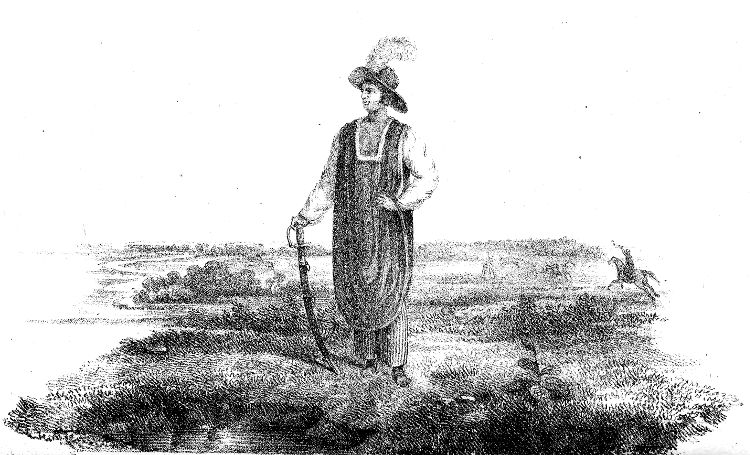
On Stone by C. Shoosmith from a Sketch by Jas. Henderson.
Printed by C. Hullmandel.
CAPTAIN OF MILITIA IN THE PROVINCE OF RIO GRANDE DO SUL.
The Pao d’Assucar (Sugar-Loaf) is upon the shore four or five leagues to the west of Maldonado, and the hill of St. Luzia a little to the east of the river of the same name. The Serra dos Tappes, which is of very small elevation, runs parallel with the lake of Patos at a distance of from four to seven leagues, being fifteen leagues long from north to south, and five broad. That of Herval is further to the north, behind the Tappes.
The extensive chains of small hills, without trees, and forming pasturage for flocks of cattle, are called cochilhas.
The before-mentioned Pao d’Assucar is at the southern extremity of the chain called the Great Cochilha, which extends itself to the north as far as the source of the river Arica. In many parts, its elevation is imperceptible, appearing like a plain, and from both sides other mountains branch off, as do some rivers which have their origin in it. The hills ranging to the west of it are not well known; the largest on the east are the Herval, the Piratinim, approximating the rivers of the same names, and the Babiragua, in the vicinity of the Camacuan. The highest points of the hills and cochilhas, and destitute of vegetation, are called serros, their summits serving on occasions of war for watchtowers, which are numerous, and some of them are seen from others at a distance of twenty leagues.
Rivers.—The numerous streams of this province almost all issue by two channels, viz. the Rio Grande de St. Pedro, which empties itself about the middle of the eastern coast, and the Rio Uruguay, which runs into the Paraguay. The Great Cochilha divides the tributary streams of those two rivers. The Uruguay originates in the lower parts of the mountains which stretch along the ocean, and runs for a considerable distance under the name of Pellotas to the westward, between margins principally of pointed and massy rocks, gathering in its course the rivers Caveiras, Caroas, Chorros, and the Correntes, which issue either from the skirts or the vicinity of the same cordillera, and water the most southern portion of the province of St. Paulo, designated by the name of Campos da Vaccaria. It here takes the name with which it terminates, and, already assuming the appearance of a large river, bends its course towards the south-west, still accumulating by other streams. In latitude 29½°, it receives the considerable river Ibicui by the left, afterwards the Mirinay by the right, then flowing southward, and ultimately the Negro by its eastern margin; has many windings and islands, and affords navigation for large boats to the first great fall, which is ten leagues below the confluence of the Ibicui. Canoes advance as far up as the centre of the vaccarias, or cattle-plains, not, however, without immense labour, occasioned by the many cataracts and rapid currents.
The river Ibicui rises in the plains of Japóguassu, and, after running many leagues to the west, turns northward for a space of twenty-five leagues, augmenting considerably by the junction of many rivers, one of them being the river Caziquey; a little below which confluence the Toropy joins it, which is larger, and comes from the cattle plains, flowing south-west, and bringing with it the river Ibicui-Mirim, that joins it on the left a little higher up. At this confluence, called Forquilha, (Three-pronged,) where the Ibicui becomes considerable, it turns to the west, and gradually augments in importance, so that much above its embouchure it is four hundred fathoms wide; a little below the Forquilha it is joined on the right by the Jaguari, a considerable stream, which also comes from the before-mentioned vaccarias. Its banks are covered with wild shrubs and trees; the tortuous channel has many islands, the current almost always tranquil, and navigable nearly to the heads of those rivers which form it.
The river Negro has its origin very near to that of the Ibicui, runs always to the south-west, is enlarged by the receipt of a number of streams, and incorporates itself with the Uruguay five leagues before that river enters the Paraguay, or Plate, after having watered eighty leagues of country, abounding, for the major part, in cattle: its largest confluent is the Hy, which it receives nearly twenty leagues above its mouth, after a course of thirty-six leagues, from east to west, through a country rich in pasturage and cattle.
The river St. Luzia takes a course, for nearly forty leagues, through a country similarly abundant, and disembogues four leagues to the west of Monte Video, having received by the right bank, a little higher up, the St. Joze, with which it becomes wide, deep, and navigable, with a good port at its mouth.
The river Jacuhy (from the bird Jacús) is formed, on the western side of the cattle-plains, by a union of various streams, which irrigate those campos, and from whence it issues being already considerable. A few leagues after having traversed the General Serra it flows eastward, describing innumerable windings for a space of thirty leagues and on a sudden turns towards the south. After a further course of fifteen miles, having become a large river, it enters the western side of the lake Patos, about four leagues below its northern extremity. Amongst other smaller streams which swell its waters, after issuing from the serra, is the Vaccahy, which rises a few leagues to the north of the Ibicuí-Guaçu, and brings with it the Vaccahy-Mirim, which has its origin a short distance from that of the Jacuhy-Mirim. These rivers were so named after cattle began to graze near them. The gentle course of the Jacuhy is uninterrupted by cataracts, and is perfectly free to navigation. The Irapuan receives a great many currents, almost all muddy and brackish, and very cold. A species of soft black stone, with white particles like silver, are found upon many parts of its banks. On being burnt, it emits a sulphureous smell, assumes the appearance of charcoal, and is said to be of no higher value. The Butucarai comes from the north, and has a bridge. Near its mouth is the passage of Fandango. The Pigueri joins the Irohy, and comes from the Serro Pellado da Encruzilhada. The Tubatingahy originates between a serro and the Encruzilhada. The Pardo, having its source in a serra, runs through a country covered with wild woods; the large stones in its bed preclude navigation: it is passed by a bridge. The Capibari flows from the vicinity of the source of the Irohy. The Antos, formed by various currents, which issue from the lower part of the cordillera, after a considerable course towards the west, turns to the south, receives the Tibicoari, and, ten leagues farther, under the latter name, enters the Jacuhy, of which it is the largest tributary, affording an open navigation to yachts as far as the confluence, where it loses the first name. The adjacent country is fertile, producing beautiful pine and other trees of excellent timber. The Jacuhy, (ten leagues below the Jacoari,) at the part where on a sudden it turns to the south, is two miles in width, forming a bay, where it receives the Cahy, which issues from the plains on the summit of the General Serra, with a course of about twenty-five leagues, almost south, and affording a navigation to yachts of ten leagues. The Sino, something smaller, which rises on the top of the same serra, more to the south, runs south-west, and is navigable for a considerable distance. The Gravatahy, which has its origin in the same hills, further to the south, runs in the same direction, and affords navigation for a space of five leagues.
The rivers Igarupay, Daymar, and Gualeguay, are the principal ones which enter the Uruguay, by the left bank, between the mouths of the Ibicuí and the Negro.
The Maldonado, and the two rivers Solis, (small and great,) discharge themselves into the gulf of the river Plate. Rio Grande de St. Pedro is the name of the outlet of the lake of Patos, and is about ten miles in length almost north and south, near one league in width, and is situated sixty leagues north-east from Cape St. Mary. The lateral lands are very flat, and destitute of trees or buildings to direct the navigator, who, at a distance only of two leagues, with clear weather, can but just distinguish the entrance to the port in 32° 4′, where the ebbing and flowing of the water generally produce an agitated sea, rendering the shoals variable, so that no ship can or should enter the port without a well experienced person, acquainted with the state of the bar.
The lake of Patos, which took its name from a nation of Indians now unknown, is the largest in the Brazil, being one hundred and fifty miles in length from north-east to south-west, parallel with the coast, and thirty-five at its greatest width, with sufficient depth for vessels of a middling size; it has, however, some very dangerous shoals. The water is salt in the southern part, with the banks generally flat. It is the recipient of almost all the currents which water the northern and eastern portion of the province, and whose principal embouchures are the Jacuhy on the north, and the river de St. Gonçalo on the south. The lake Mirim, which signifies “small,” compared with the other, is ninety miles in length, and twenty-five at its greatest width; this also extends along the coast, and discharges into the lake Patos, by a channel, fifty miles long, wide, handsome, and navigable, and constituting the aforesaid river de St. Gonçalo. The river Saboyaty, after having collected many others, flows, in a considerable stream, into the southern extremity of the lake Mirim, and is navigable for many leagues. The small river Chuy disembogues almost in the middle of the same lake; and, further to the north, the river Jaguaron, which has its source near the lake Formoza, (beautiful.) It has a course of about eighty miles, and eighteen of navigation. The river Piratirim which has its origin also near the lake Formoza, empties itself about the middle of the St. Gonçalo, after a course of thirty leagues, affording ten miles of navigation. The river Pellotas, rising in the serra of the Tappes, enters the St. Gonçalo near its mouth, and admits of small vessels for five leagues. Passing the embouchure of the St. Gonçalo, the first river met with on the lake Patos is the Contagem, which is about fourteen leagues in extent. The second is the Correntes. The third is the Canguçu, navigable for some leagues. The fourth runs under the name of St. Lourenço. The fifth denominated Boqueirao, and the least of all, originates, like the others, in the Serra dos Tappes. Above the Boqueirao, in the middle of the lake of Patos, the Camapuan empties itself by five mouths, formed by four islands, the largest of which is half a league in circumference. It flows from the Great Cochilha by a rapid course of nearly one hundred miles, amongst rocks and stones, admitting navigation only for a distance of four leagues, and higher up presenting continued cataracts. By its southern margin fourteen currents are admitted, some of them ten leagues in extent; and fifteen by its northern bank, none exceeding five leagues. The southern ones, commencing from the mouth of the river, are the Pereira, rising in the Serra dos Tappes; the Cardozo; the Evaristo; the Meirelles; the Sapata, which flows from the same serra; the small river Pedras, (Stones,) rising near the situation called Igatimi; the Almeida; the Arroio Grande; the Velhaco, originating in the Grand Cochilha, near the Serro Bay, and running through a bed consisting in parts of rugged and craggy prominences; the Fagundes, which runs for five leagues between rocks, with many falls; the Rodrigues, rolling angrily over precipices, and foaming between rocks and stones; the Arroio da Palma, considerable, serene, well stored with fish, and navigable for small craft; (the quadruped capibara is seen upon its banks in bands of eighty and one hundred;) and the Camapuan Chici, tranquil in its course, receiving, amongst other streams, one called Tigre. The adjacent territory consists of fine campos, fertile in corn.
Passing the mouth of the Camapuan, northward, the Duro is first met with, which runs through a flat open country, without wood, and forms in its course some lakes. Next, the Velhaco, flowing rapidly through woods. Beyond this is the Passo Grande, with like umbrageous borders.
Proceeding up by the Jacuhy to the town of Portalegre, on the left bank is the Araca, rising in the Serra Herval, and the Antonio Alves, which, three leagues above its mouth, receives the Doudarilho, and affords an open navigation to hyates, or yachts. At the northern extremity of the lake Patos the river Palmares enters, having its source in the neighbouring plains of the Tramandahy. Three leagues to the west of it runs the Capibara, which is only a current in winter, when the lake of Serra, receiving the waters of various small brooks, discharges them through this outlet: the lake is about eighteen miles long and five wide, and runs parallel with the cordillera. The country which these rivers traverse is a plain of white sand, and in great part marshy, producing, however, some herbage, brushwood, and plantations.
Along the coast, which runs from Cape St. Mary to the little Castilhos, are various lakes approximating to the sea. The lake Manglieira, which is eighty miles long and about four broad, extends between the coast and the lake Mirim, and empties itself, at the northern extremity, by an outlet called Arroio Thahim. The peninsula between the coast and the lake of Patos, from two to six leagues in width, is interspersed with a great number of lakes, generally running into the ocean, or into others. Amongst those extending westward we may remark, in the southern part, the Capibaras, into which a small river empties itself of limpid water, bursting suddenly forth with admirable force, and is the purest in the peninsula, which, nevertheless, is not deficient in good potable waters. On the eastern side of the peninsula is the lake Mostardas, better known by the name of Peixe, nine leagues long, with little width, extending along the margin of the sea to the point where it disembogues through an elbow of land, that opens and closes annually, and by which various species of fish enter; the most numerous are denominated miragarga, resembling the cod-fish. With this lake various others communicate, that lie to the north, and are connected by their different mouths. Near the last, that terminates the extent of the Barros Vermelhos, another chain of a similar description commences, at a short distance from the beach, and extends parallel with it for a space of twenty-five leagues.
A short way from Barros Vermelhos, and by the side of the sea, there is a small lake that runs into a larger one, which terminates in the Capoes do Retuvado. It has an outlet into another, that extends from hence a league and a half. Beyond these there are two lakes running parallel; and still further another, near the Capao do Xavier, a distance of two leagues, which discharges itself into the lake Charqueada, the latter terminating in the place of that name, and running by a vein into a smaller one: this empties itself into a lake of equal size, and that is joined to a larger, which terminates in the Capao Dastacoáras. The last discharges itself into the Quintao, which runs into the Cidreira. The Cidreira is divided into three bays or lakes, communicating by necks or outlets, and occupying an extent of four leagues and a half. It has a channel of two miles long to the Ribeiro, terminating near the passage of the Arroio, its outlet to the river Tramandahy. The river Tramandahy is in 30° south latitude, and is nothing more than the channel of discharge to a great number of lakes, spreading themselves over the extensive plains that lie between the beach and the cordillera. Into this river also is discharged the most southern of another chain of lakes, that extend themselves along the same cordillera northward, very near to the river Mombituba, at the mouth of which there is a military detachment, in order to register persons entering or leaving the province. In the space of twelve leagues, which lie between the Tramandahy and the Mombituba, fourteen small rivers of crystalline water are discharged into the sea.
The afore-mentioned peninsula, formed by the lake Patos and the ocean, is level ground, with a small elevation, or albardao, near the middle; it is almost in a direct line on the eastern side, forming various points and bays on the opposite one. Among the first is the Ponta do Mandanha, commencing at the south, where have been found the vestiges of an Indian village and cemetery. Next to this the Ponta Raza; between them the lake das Capibaras discharges itself. In the middle of the bay called Barrancas, which is the best shelter in this lake for all vessels, some small rivers are emptied, one of which is navigated by canoes and other boats. The Ponta of Bujurú is six leagues more to the north. Into the middle of a bay of the same name, runs a fine river, which forms a little island at the bar. The point of Christovam Pereira is six leagues further. In the bay, which is to the southward of it, there are two considerable mountains of shells, which prove how much the Indians were attached to shell-fish. The point and bay of Cacira are more to the north, and the last that are remarkable. The ground is generally of a very sandy soil, but in some parts clay is found below the sand, which shows that the peninsula is not formed by the sand of the sea, but that the ancient soil is covered with it. Between the lakes Mirim and Mangueira, for many leagues, the small river Chuy takes its course, and enters the ocean in front of the southern extremity of the first.
Capes, Ports, and Islands.—St. Mary is the only cape. Monte Video, St. Luzia, and Maldonado are the best ports. The islands of Castilhos, near the point of the same name, and Maldonado, in the entrance of the bay of the same name, are both small. The isle of Lobos, (Wolves,) two miles in circumference, has good water, is almost all rocks and stones, and lies four leagues to the south-east of the preceding one. There are two others to the south-west of Cape St. Mary. The isle das Flores, half a league long, and of little width, is flat, and six miles to the east of Monte Video. The isle of Martim Garcia is to the west-north-west of the bay of Colonia do Sacramento, in front of the mouth of the river St. Francisco. The isle of St. Gabriel, four hundred and fifty fathoms long, its width proportionable, is in front of Colonia; as well as the isle of Antonio Lopes, and the English Island, both small. That of Fornos, two hundred and forty fathoms long, approximates nearer to the beach. The island of Marinheiros, three to four leagues in circuit, flat and covered with trees and brushwood, is near the southern extremity of the lake of Patos, and a little to the north of the town of St. Pedro, whose inhabitants have recourse to it for water and firewood.
Mineralogy.—Terra-sombra, or umber, calcareous stone, potters’ earth, gold, silver, and sulphureous minerals.
Phytology.—Timber is more remarkable here for its fine quality than its abundance. From the parallel of 30° degrees southward, on the banks of the principal rivers only, are to be seen any forests of fine full-grown timber. Out of these latitudes, in this province, trees are rare and of small size. In the southern parts, they burn bones and the excrements of cattle, in consequence of the scarcity of wood. In the northern there are beautiful pine trees.
Zoology.—Five nations held their dominion in this province. The Patos in the peninsula, and to the north of the lake which has taken their name; the Charruas, around the lake Mirim, and as far as the river Plate; the Minuânos, to the westward of the latter; the Tappes, from the lake Patos to the Uruguay; the Guaycanans, in the cattle plains, where they still reside at times. Of the first there is now no account, and they appear to be extinct, having most probably intermixed with other tribes. The Charrúas have retired into the centre of the country. The Minuânos occupy the lands to the westward of the Tappes from the Ibicui southward. Between the Minuânos and the Charrúas enmity perpetually exists, and frequently wars occur. They both use the lance, the arrow, and the sling, and are expert on horseback. Grapuetan is the name of the country where the Minuânos reside for a considerable part of the year. The Tappes in great numbers formerly lived under the influence of the Christian missions of the Uruguay.
Amongst other species of wild quadrupeds, there are the anta, like a little cow without horns, as common in the West Indies, the deer, the ounce, the monkey, the paca, like a pig of two months old, the rabbit, quati, cotia, tatous, or armadillo, covered with scales, the jaraticáca, or squash, which the Spaniards and Portuguese call forrilho, the boar, the fox, with various kinds of dogs, viz. the jaguaratirica, guará, guaraxain, and the jaguane. The race of the European species of dog have here multiplied excessively, so that they live in the plains, where they subsist with others of the wild kind, without ever entering any village or dwelling. They are called chimarrōe dogs. Immediately on the slaughter of cattle ceasing, and when in want of provisions, they assemble together in large bands, and encircle an ox, which they pursue with unceasing obstinacy until the animal falls with fatigue, and is devoured by them in a few hours. A horseman even runs a risk in the plains, when they are in a state of famine. No province in the Brazil abounds with such prodigious herds of cattle, horses, and mules. Goats are not very numerous. The sheep produce a fine wool.
In the beginning of the last century this province was covered with cattle, in spite of the devastation which the Indian and the ounce had made amongst them. The conquerors, persuaded that such a profusion of cattle never would have an end, commenced by carrying on a destruction amongst them resembling that of the tiger and the wolf in the sheepfold. This havoc was principally directed against the calves, and generally one did not suffice for the dinner of two comrades; probably they both wished to eat the tongue, and to make a greater certainty of it they killed a second calf, rather than divide the first. There were men who killed an animal in the morning in order to breakfast on broiled kidneys; and, not to be incommoded by carrying any part of the meat for dinner, performed the same operation by killing the best they could discover for dinner. There was no banquet without veal only a few days old.
Don Joaquim Vianna, governor of Monte Video, hearing of this destruction of the cattle, and informed of the cause, issued an order, about the year 1650, with a heavy penalty attached to its transgression, that no more calves or cows should be killed, excepting such cows as were barren; and that no bulls or oxen should be slaughtered for their skins, excepting those of five years of age and upwards. In the vice-royalty of the Marquis de Lavradio, some good arrangements were made in the northern part of the province; but all were not under their influence, in consequence of the widely spreading districts, to many of which they did not extend.
Two small portions of the cattle of this province are appropriated, one to the consumption of the country, and the other to the slaughter-house of the metropolis; but the far greatest proportion is manufactured into jirked-beef, which is salted without bones, dried in the sun, and exported to the principal ports in the Brazil; but, from the desultory warfare carried on near the river Plate, it has recently become very scarce, and bacalhao, or salt fish, brought by British ships to the ports of Brazil, has become a substitute at many places.
In 1802, there were yet only amongst the subjects of the faithful crown, five hundred and thirty-nine proprietors of land, judicially marked out amongst the breeders of cattle, denominated fazendeiros, or farmers, and lavradores, or husbandmen, which latter breed only what is necessary for their own service and consumption; they possess generally about two square leagues of land: but those of the first order have eight or ten square leagues, and some even more. The greatest proportion of the cattle are breeding cows. In a plain or field of three leagues are usually bred four or five thousand head, and proportionably more or less, according to the quality of the land, or attention of the breeder. The pasturage is not, however, generally good, the soil being, as before mentioned, of a sandy nature.
For the management of a fazenda of five thousand head of cattle, it is said six men are sufficient, with one hundred horses at least; the whole of which pasture together in troops of twenty, with a tamed mare, from which they do not usually stray. From the sandy nature of the soil, as in many other parts of Brazil, particularly at Pernambuco, no expense is incurred by the owners for shoeing them. In each establishment, or tract of land, there is commonly a small hill, or the most elevated land is selected, as plain and even at the summit as possible, which is known by the name of rodeio, (a certain compass of land,) and is capable of receiving the whole flock, when brought together. For this purpose, the shepherds on horseback distribute themselves round about the cattle, and cry out loudly “Rodeio, rodeio, rodeio;” at whose voices the cattle march at full trot towards the rodeio, in files, divided into droves or bands of fifty to one hundred, according to the numbers that pasture together. This mode of forming them early into troops is indispensable, in order to put on the mark of the dono or proprietor upon such as have it not, and with more facility to select those that are upwards of four years old for the market, or for carne-secco, or jirked beef.
If the stock of cattle exceed the number of heads which the fazenda is capable of sustaining, they of course run short of pasturage, and many spread out into more distant plains, and after a time will no longer obey the rodeio, but fly and disorder the rest of the flock.
In a fazenda of three leagues it is computed that one thousand young cattle, male and female, are branded or marked, annually; consequently the number they send off or kill may be estimated in the same ratio.
The farmers also breed a certain number of domestic cattle. He who possesses four thousand cattle, which are denominated bravo, or wild, keeps commonly one hundred milch cows, which, however, pasture in the same fields or plains with the others. When a cow calves, she always selects a situation adapted to the concealment of her young, where it continues in secrecy for the space of eight days. She visits it at different times in the course of the day, in order to give it suck, lying by it at night. It is difficult to find them during this period; but once discovered the calf is immediately conducted to the cattle fold, where it is kept eight or nine months or more, being daily visited by its dam, which is milked the whole of this time, for the purpose of making butter and cheese, leaving to the prisoner only what it can draw from its mother after she has been milked. The familiarity of the young one with the persons upon the fazenda preserves it in a state of tameness. The males, when sufficiently grown, are used in the cart or plough, and the females pasture in the plains till they become mothers, continuing to supply the farmer with an increasing stock.
Although the domesticated cattle are not bred up with such a satiety of provision as the wild ones, which enjoy the whole of the mother’s milk, and pasture the entire day without working, yet they grow as large and become fatter. This is attributed to the fearful nature of the undomesticated kind, who fly from every animal that appears; whilst the tame ones, although they eat less, live in quiet, always retaining the habit of going to the fold, and approaching people without alarm; they are also less time in the fields, consuming less pasturage, and it is estimated that the aliment which four thousand head of wild cattle exhaust is sufficient to sustain eight thousand of the tame. The meat of the latter is esteemed the most savoury.
The same fazendeiros breed also droves of horses and mules. The latter are the most lucrative, a male one being at least double the value of a horse; and in consequence, its species is more numerous, although very few persons breed more than two hundred annually. The she mules of two years old are either sold or separated from the rest, in order to avoid the destruction which they would cause in the species. A she mule seeing the foal of a mare, immediately begins to caress it as her own, and will not allow the mother to approach to give it milk; the result is, that it perishes with hunger.
The breed of sheep would, if attended to, much exceed that of cattle, in consequence of their generally producing two at a birth; they are not however numerous, few farmers possessing one thousand head, and the major part not any. Nothing here appears so easy and cheap as the multiplication of this animal. For the purpose of shepherding a flock of one thousand, two cur dogs are sufficient, bred up in the following mode. As soon as they are whelped, the lambs of a ewe are killed, the puppies are put to her, and she suckles them until she becomes habituated to treat them as her young, when, upon opening their eyes and seeing no other benefactor, they attach themselves to her, and play with the lambs as if they were of the same species. Nothing is ever given them to eat; they are shut in the fold with the sheep, and on obtaining strength and vigour to attend the flock, they are suffered to go at large, when they accompany it to the field. In a little time, and without more instruction, they are so familiarized with the sheep, that they never separate from them. When it happens that a ewe lambs in the field, and the lamb cannot accompany the mother, in consequence of its not yet having sufficient strength to follow her, one of the dogs watches near, and if he finds that the lamb cannot follow the mother to the flock, he carries it in his mouth, without doing it the least harm. No other animal or unknown person can approach the sheep, of which these dogs are the guardians, without the risk of being attacked. The other domestic dogs and the hordes of the chimarroe dogs are the greatest enemies to the flock; against them and the birds of prey, which pick out the eyes of the lambs, the vigilance of the watch dogs is requisite.
Amongst other species of birds are the Macuco partridge, the parrot, caroe, inhuma, sócó, tayugu, jaluerá, heron, jacu, the araponga mutum, tucano, and the quail. In the lakes are large numbers of wild ducks, and large wild geese, some brown, some white, others with black necks, which when stripped of their feathers, are covered with a fine long down, similar to the Armenian fur, and serving for the same uses. The marine geese, which have a bill like a turkey, with smaller wings and without feathers, for the most part go at the bottom of the sea, and are seen occasionally upon this coast, as well as the sea calf. It is said, that here the emu ostrich lays many eggs in one nest, to which they never return after having finished laying; the male then hatches them, after instinctively breaking two, for the collection of a large quantity of flies; thus the young find sustenance till they are able to accompany their protector, when he remains their guide for several days. The people do not generally follow hunting or shooting, so that game is very abundant; neither are they partial to fishing.
The inhabitants are instructed in the use of the laço, in order to catch wild cattle. It is a cord of twisted leather, secured by one end of the saddle or girth of the horse, upon which the laçador is mounted, the other end forms a noose through which the cord runs, and, curling it up, the horseman throws with dexterity to a great distance, and secures the animal by the horns or the neck. The sagacious horse instantly throws itself into a firmly inclining posture, to resist the opposing power of the animal to escape. There are men so skilled in this art, that they catch the wary ounce with the laço. The laçador as quickly dismounts and despatches it.
They are not less dexterous in the management of the balls, which are two round stones secured at the extremity of a cord, formed also of leather, and being thrown at the legs of the animal, unexpectedly entangles them so effectually, that it cannot move another step. These species of weapons are used by them against each other. This custom was borrowed from the Maraocoto and other Indian tribes, who used the laço and balls with great effect against Mendonça when he landed and founded the city of Buenos Ayres. The Peons, who act as guides, as well as others of mixed origin, are expert with these weapons.
The Spaniards denominate the progeny of the Indian and Negro, Somboloros; and of these latter and the Mulatto, Saccalaguas; the son of a Mestico (offspring of a white and an Indian) and an Indian, Cholo. The Portuguese call the first Curibocas.
The principal towns in this province are St. Pedro, Portalegre, and Monte Video.
St. Pedro is a commercial town, and advantageously situated upon the extremity of a tongue of land, between the gulf of Manguein to the south and a bay to the north-east. It has a church dedicated to the apostle from whom the town derives its name. It has two orders of devout women; the one called St. Francisco and the other Carmo. The houses are generally very wretched, and the streets of a fine sand, the same as that of the neighbourhood. It enters so profusely into the houses, at the season of the high winds, that it is impossible to eat any thing without a portion of sand being intermixed with it. This town, begun a league to the south-west, in the situation called Estreito, was removed by Gomes Freyre d’Andrade, between the years 1747 and 1750, and was the capital till the year 1763. The heat is intense. Cats fly from the rats, which are large and exceedingly numerous; but they have a formidable enemy in the dog. Here are some English establishments in connexion with houses at Rio de Janeiro.
Upon the eastern bank of the river, in front of St. Pedro, is the considerable and flourishing arraial of St. Joze, with a hermitage of the same name. It is the town’s port; and, in 1814, there sailed from it three hundred and thirty-three vessels of various kinds, laden with wheat, hides, carne-secco, or dried beef, tallow, cheese, and other articles. Six leagues to the south of St. Pedro is the arraial of Povo Novo, ornamented with a hermitage of Nosso Senhora das Necessidades. Its inhabitants, originally from the Azore islands, are husbandmen.
Portalegre (delightful port) is a large, populous, and commercial town, has good houses, and straight streets, principally paved, and is situated upon the southern margin of a bay to the eastward of the Jacuhy, seven leagues above its mouth, and forty-three leagues north of St. Pedro. It is the capital of the province, the residence of the governor, now Conde de Figura, of the ouvidor, and a vicar-general. It has a church, dedicated to Our Lady Madre de Deos, (Mother of God,) the chapel Das Dores, (of Grief,) an hospital, a Junta da Fazenda Real, (a treasury,) and a Cadeira regia de Latim, (a royal professorship of Latin.) The senate is presided by a Juiz de Fora, or a judge similar to a mayor, who also presides over the orphan establishment.
With the loss of the town of St. Pedro, in 1762, the village of Nosso Senhora de Conceiçao, became the capital, and the hermitage with which it was ornamented the parochial for some years, inasmuch as the governor, Joze Marcellino de Figueyredo did not remove the seat of government; but increased and improved this village, to which he gave the name so appropriate to its good port. In 1808, it received the title of town.
A great part of the commodities that are exported from the port of the town of St. Pedro, are shipped thither from Portalegre, in hyates, or small craft.
The adjacent country is fertile and watered by the Cahy, Caravatahy, and other rivers.
About four leagues to the north-east of Portalegre, and not quite a mile from the right bank of the Caravatahy, in an elevated and fine situation, is the parish of Nosso Senhora dos Anjos, founded by the same governor, J. M. de Figueyredo, for the habitation of various Tappe Indian families, fugitives from the missions of the Uruguay. These Indians established a large fazenda for breeding cattle, in order that they might better sustain themselves; and who, notwithstanding they were freed from the capitation, and exempted from the rod and discipline under which they had been brought up, withdrew by degrees to various situations in the province. The river is very winding, its banks abounding with timber, stone, and fine potters’ clay.
A little more than thirty-five miles to the west of Portalegre is the considerable and delightful arraial of the new parish, near the mouth of the Tacoary. Its inhabitants raise wheat and cattle.
About eighteen miles to the north is the parish of St. Joze, with a large praca, or square, on which is the mother church. It was the source of the agriculture of this province, and its people are mostly descendants of the first settlers from the Azores; from whence Senhor Don Joze brought various families. They began to cultivate wheat and Indian corn according to the method of their own country, and which is at this day the occupation and support of their posterity.
Little more than three leagues to the west of the new parish, is situated the pleasant arraial of St. Amaro, also upon the northern margin of the Jacuhy, and ornamented with a magnificent church.
Eight leagues to the west of St. Amaro is the considerable town of Rio Pardo, at the mouth of the river from which it borrows the name, and has a church called Nossa Senhora do Rozario; also two chapels. It occupies four small eminences, and had its commencement with a fort dedicated to St. Lourenço, received the title of town in 1812, and that of a countship in 1815.
About two miles from it is the village of St. Nicoláu, with a hermitage of that name. The people who inhabit it are descended from the aborigines. About twelve leagues south of Rio Pardo is the arraial and chapel of St. Barbara da Encruzilhada, in an elevated and pleasant situation, and having most excellent waters. Ten leagues above Rio Pardo, upon the northern bank of the Jacuhy, is the considerable arraial of Cachoeirá, with a church of the Lady of Conceiçao. It has wide, straight, and clean streets, and possesses advantages for becoming much more considerable.
Twelve leagues to the south of Cachoeirá is situated the arraial of Cussapabá, upon a small hill near the source of the river St. Barbara, with the chapel of the Lady of Assumpçao.
North-east of Portalegre about fifteen leagues is the small town of St. Antonio da Patrulha, near the road, in an elevated country. Its inhabitants cultivate mandioca, sugar, and bananas, with other fruits.
To the north of Patrulha, in an extensive plain upon the General Serra, is the parish of Nossa Senhora do Oliveira. Cattle are its main commodity.
The peninsula formed by the ocean and the lake Patos is divided into three parishes. To the west of the lakes Patos and Mirim are the parishes of Espirito Santo, Nossa Senhora da Conceiçao de Piratinin, St. Francisco de Paulo, Nossa Senhora de Conceiçao de Canguçú, in the vicinity of the river Camapuan, and St. Sebastiam do Bajé, near the origin of that river; all in the diocese of Rio de Janeiro.
The following places are in the diocese of Buenos Ayres.
Monte Video, with the title of city, is situated in a pleasant plain at the extremity of a peninsula, which forms the eastern side of a bay almost two leagues long, and one wide at the entrance. It is fortified with various batteries towards the sea, and a citadel on the land side. It has a church dedicated to the apostles St. Filippi and St. Tiago, a convent of St. Franciscans, an hospital, good houses with flat roofs and parapets, and straight streets. The inhabitants enjoy a salubrious air, but are inconvenienced from the want of wood. They drink rain-water, collected in cisterns, which are formed in the inner courts common to the houses, and this water is pure and excellent. There are also pits dug near the sea-side, from whence water is brought in carts for the supply of the town. It is one hundred and thirty miles to the west of Cape St. Mary, and one hundred and twenty east of Buenos Ayres. Its port, at the extremity of which there is a small island fortified, has not sufficient depth of water in all parts for large vessels. The pamperos, which are furious tempests from the south-west, occasion at times very great injury, and the sea here is greatly subjected to the influence of these winds. It was taken by the English in June, 1807, and given up again at the end of some months. There are a few English establishments here, but the trade is trifling compared with that of Buenos Ayres. The suburbs are thickly inhabited, and have two parochials, both dedicated to Our Lady of Carmo. More distant there are two others, Pinheral and Pedras, and their parishioners are breeders of cattle.
Maldonado is a small town, but which, with much facility, might become very considerable, from the circumstances of its favourable situation upon a fine bay, bearing the same name, and the fertility of its adjacent district. It is adorned by the church of St. Carlos; and the inhabitants are chiefly descendants of the Portuguese. It is fifteen leagues west of Cape St. Mary.
Pueblo Novo, founded for the habitation of the Portuguese prisoners of Colonia do Sacramento, is two leagues to the north of Maldonado, and has a church called St. Carlos. Near twenty-five leagues to the north of Pueblo Novo is the parish of Nossa Senhora da Conceiçao de Minas.
St. Domingos Suriano is a small town, well situated near the mouth of the river Negro, in a country abundant in corn and pastures, where large quantities of cattle are bred, which, with lime, are the principal exports. Eight leagues distant from St. Domingos Suriano is the parish of Nossa Senhora das Merces, near the margin of the Negro. About five leagues from the same place upon the St. Salvador, is the parish of Espenilho; and fourteen leagues from Espenilho, that of Viboras.
Nine leagues to the north-east of Monte Video is the parish of Nossa Senhora of Guadalupe de Canneloes. There are also the parishes of Perongos, which is in the central part of the district; of Hy, upon the river from which it takes the name; of St. Joze and of St. Luzia, near the rivers which bear their names; of Sacramento, where the Portuguese founded it; and of Pintado, along the sea. Serro Largo, with the title of a town, is delightfully situated near the place of the same name, and is the nearest to the Portuguese frontiers.