"Sport and Travel in South Africa" (continued 6)
Reading edition
As a country Ovampoland is rich in game of every description, corn and native products. Cotton, if cultivated, would be a valuable product for exportation, but at the present time it is no country for emigration, being extensively occupied by too many uncivilised natives, who are averse to whites living in that country. It is only fit to be preserved at present to the British crown for its native produce and an outlet for British merchandise.
Before leaving Ovampo it will be necessary to give some short description of the ants and ant-hills which are in every conceivable form and size. First comes the lion-ant, that lives in the bottom of a little funnel-shaped hole in the sand, about four inches in depth and four inches in diameter. Any fly or small ant coming near falls down with the rolling sand, when out springs the ant, carries him under the sand where he has been watching for his prey, and, when devoured, waits for another. The largest specimen in my possession only measures half an inch in length. The smallest ant makes a little circular ring of sand formed by the ground brought out from a small hole just beneath the ground. They ate so small that when put upon a white sheet of paper they look like fine dust; and yet these little industrious insects form such beautiful and perfect nests with cells in the ground, the extent of which seldom exceeds the size of a small apple. There is a variety of ant-hills over the country, some of them seventeen feet in height and sixty feet in circumference, made by the small white ant, which is so destructive to buildings. Mosquitoes also infest the country near the swamps and lagoons. My Bushmen and Hottentots had a very ingenious method of being free from them at night by digging holes in the ground where they intended to sleep, covering themselves in their blankets in these holes, and throwing bushes over them as they disposed themselves to sleep. Sand-flies were also very annoying, and as evening closed in hundreds of fire-flies would be seen in all directions, not forgetting the crickets and frogs, which would keep up a perfect din of noises. Beetles of every description and size, particularly some very large rhinoceros-beetles, swarm all over the country. Then there is that small animal called the skunk, with black and white fur, but which gives out a most offensive smell, more pungent than the pole-cat. The swamps seem full of the water-tortoise, and the land-tortoise is also very common and grows to a great size. Tree-toads and tree-lizards may be seen in the old trees and on the branches. I have found many leaf insects in the desert of various kinds. They look very peculiar walking along; some of them are very pretty, many of a light-green colour, others like brown leaves. There are a great variety of beautiful birds, where water is not far away, and the goat-sucker is a constant visitor at the camp. But of all the most welcome birds is the turtle-dove. When we hear its call we know water is not far away. If proper means were adopted to procure water this region would be capable of supporting a large population, as the country is rich in almost everything that man requires, and is most healthy. The first step to take to open up this part of the desert is to improve the road from Walfish Bay to Lake N’gami, and open out the fountains. This would lessen the distance to our interior trade 800 miles.
Of late years the game of the country has been greatly reduced in consequence of the natives having guns.
Chapter Sixteen.
The Transvaal Republic.
In describing the geographical position of this Republic in relation to the adjoining colonies, Free State, and native territories, it will be necessary, before entering upon its physical formation, to give an outline of its boundaries, and the important position it holds in the future commerce of the country with the interior trade of South Central Africa. All the northern portion is situated in the Limpopo river basin, the southern in the basin of the Orange and Vaal rivers. The central watershed being the division which runs east and west from New Scotland, passing half-way between Potchefstroom and Pretoria, on to the western boundary near the village of Lichtenburg. The boundary from Griqualand West, east of “Fourteen-streams” on the Vaal river, up that river to Klip river (a tributary of the Vaal, up which it runs to Gans Spruit, to where it joins the northern point of Natal), is the division between this Republic and the Orange Free State. From thence along the Drakensberg for a few miles in an easterly direction to the Buffalo river, down that river south to the Blood river, a tributary of the Buffalo, which is the division between this Republic and Natal. From the Buffalo up the Blood river to its source in the Magidila mountain, from thence to the conical hill between the Pongola river and the Drakensberg mountain, is the Zulu boundary. The eastern boundary is separated from the Portuguese possessions by the Lobombo range, the Umzila country, and the Amatonga Kaffirs. The Limpopo river is the northern boundary, and the western and north-western by the chiefs Khama, Sechele, Gaseitsive, Montsoia, and Monkuruan territories, and Griqualand West, down to Fourteen-streams, on the Vaal river, before named. The Republic is situated between 22 degrees 15 minutes and 28 degrees 20 minutes South latitude, and 25 degrees 20 minutes and 32 degrees 10 minutes East longitude, and contains about 122,000 square miles.
The principal rivers are the Limpopo and the Vaal; the former rises in the high watershed, south of Pretoria, at an altitude of 6300 feet above sea-level, flowing in a north-north-west direction through a very pretty and picturesque part in the Magalisberg range of mountains, which run east and west, on to where the Great Marico river falls into it, in 24 degrees 15 minutes South latitude, 27 degrees 7 minutes East longitude, at an altitude of 2690 feet, passing through a thickly wooded country with many native kraals, skirting Dwaasberg and other lofty hills that add much to the beauty of the landscape. From the junction of the Marico, the river turns in a northerly direction for about forty miles, where the Notuane river joins it; from this point the Limpopo turns with many bends and curves in a north-easterly and easterly direction for some 400 miles, forming the boundary between the Transvaal and the chief Khama, and the Matabele nation, down to 31 degrees 54 minutes East longitude, being the north-east corner of the Transvaal, and where the chief Umzelas territory joins up; from this point, after flowing east for some twenty miles, it takes a south-south-east direction, through Umzelas country to the Indian Ocean. It is a fine, broad stream, increasing in width from the junction of the Great Marico, where it is about 150 yards; at the Mokalapsie river, it is 200 yards; at the junction of the Shasha, 220 yards; and increases in size as it passes on through the low, flat country to the sea, where it is three miles wide. It can be made without any difficulty navigable up to the Rubie river distant from its mouth nearly 300 miles, taking into consideration the sinuosity of its course, whence a good road could be made to the interior; above this point there are many falls and rapids, the two most important are the Impopomene and the Tolo, above-named, both beautifully situated between thickly wooded banks; and over the granite rocks in its bed the water falls, and where some of the bed rocks are exposed, in the dry season may be seen hundreds of deep circular holes from one foot to six feet in depth, and from one to three feet in diameter, that have been worn by loose stones in the first instance being revolved round in a depression in the rock, and in time, by the rushing of the waters upon them, have increased them to the present size; they are similar in shape to those on the banks of the Vaal, Orange, and Zambese rivers. The immensity of time it must have taken to wear away such deep and large holes in a granite rock, makes one pause to think of the period when this river was first formed, because it is only a portion of the year, when the floods come down, that the water acts upon the stones in these holes. The principal tributaries of the Limpopo that rise in the Transvaal are the Apies at Pretoria, Sand, Pinaars, Plat, Matlabatse, Pongola, Palala, Nylstroom, Houdt, Limvubu, and the Olifants river with its many tributaries, all flowing into the Limpopo on its right bank. The greater portion of the country which these branches pass through is called the Bush Veldt, Waterburg, Zoutpansberg, and is principally occupied by native tribes under their respective chiefs. Extensive districts are infested with the tsetse-fly, where a traveller cannot go in with horses or oxen, for one single bite is death.
Many parts of this bush country, now unoccupied, must at some remote time have been thickly inhabited, as many remains of cultivated ground are seen in all directions—and large heaps of stones thrown up when the ground was cleared for corn, as is the custom with all the natives when they prepare the land for cultivation—but it has long since been overgrown with timber and thick bush.
Nearly the whole of Waterberg and Zoutpansberg districts, up to the Limpopo, and down to the Magalisberg range, a little north of Pretoria, is a mountainous region; the latter mountains run in an easterly and westerly direction to the Marico district, the south face having perpendicular and rocky sides, the northern face slopes gradually, and this is the case with most of the mountains in this part of Africa. The Dwaasberg, through which the Great Marico river has forced a passage, joins on to Wittfontainberg. Pilandsberg is more to the east, north of which is the Karroo desert, where is the Marikele mountain, a long range running in an east-north-east direction to Hangklip mountain, with detached hills up to Marabas town, where gold has been found and a company has long been established, with quartz-crushing machines to extract it. A gold-mining company has been established at Nylstroom; copper has been found in many localities.
The Mural mountain range on the western border runs in a north-east direction for seventy miles, and terminates at the northern point of the Pongola river, and can be seen at Mongwato, nearly 100 miles distant. Makapan’s poort is a lofty mountain, a complete honeycomb of caves, where much fighting has taken place between the Boers and the chief Makapan. The Marico district is a continuation of hills and fine rich valleys, the Quaka, Kolobekatseberg, and to the north, Blaauwberg and many isolated hills, north of Marabas stad, in the Zoutpansberg district, with the mountain of the same name, reaches as far as the Limpopo, with the Pweede and Derdebergs. To the east of Marabas Stad are many detached ranges, the Matyatyeberg, Spelunken, and Murchisonsberg, situated on the north of the Olifants river; north and south-west of Lydenburg are the Magnet heights and Lolu mountains range—well known from the Secocoenes stronghold, stormed by Lord Wolseley when Secocoene was taken prisoner.
To the east of Lydenburg is the continuation of the Drakensberg or Quathlamba range, broken up into lofty mountains attaining a height of 7000 feet; some of the highest are Steen Kamps, Komati, Slangapies, Rands, and Verzamelberg. The whole of this part of the Transvaal is rich in minerals, wood, and water.
The climate is mild, mostly very healthy; some parts are fever districts. The native population exceeds 300,000, divided into various tribes, that are located to the north of Pretoria and Lydenburg, to the Limpopo, and are composed mostly of Mantatees or Makatees, and also are known as Mahowas, and are divided into several kraals under petty chiefs. These are the origin of the Basutus. Their queen was called Mantantezi, and Mosesh, her head-man, deposed and drove her out, and formed the Basutu nation, once so powerful that they endangered a large force of ours under Sir G. Cathcart. There are also what are termed Knobnoses, Basutos, Zulus, Pula Pula or goat tribe, Vaalpans or slaves, that have no resting-place, but roam the country. Then there are the two queens, Majaji and Maselaroon, also Albasini, a Portuguese at Zoutpansberg. Polygamy is common amongst all the tribes; a man may have as many wives as he can purchase and keep; they do the greater portion of the work, till the ground, gather in the corn, fetch wood and water, cook, and such other labour as is required.
The principal towns in the northern division are, Nylstroom, in Waterberg; Marabas Stad, in Zoutpansberg, with small villages of Upsal, Eersteling, and Hantbosch; Lydenburg, with the gold-diggers’ camps, in the Lydenburg district; Rustenberg, in the Rustenberg district; Middleburg, in the Middleburg district; and Pretoria, which is the capital of the Republic and a bishop’s see, is situated in 25 degrees 40 minutes South latitude, and 28 degrees 32 minutes East longitude.
The other rivers in the northern division, and within the Limpopo basin, are the Crocodile, with its many tributaries, rising in the Drakensberg or Quathlamba range, and, passing through the Lobombo mountain, receives the Umcomasi, Sabie, and other small streams, and enters the northern part of Delagoa Bay. The Umbelosi drains the country south of the Komati, and passing through the Lobombo range, enters Delagoa Bay, or inner harbour at Lozrenzo Marques; it is navigable from the bay some few miles from its mouth. South of this river is the Tembe, which rising in the Lobombo mountains, with its small tributaries, enters the inner harbour. The last of the rivers that drain the south-eastern portion of the Transvaal is the important Maputa or Usutu river, which rises in the New Scotland district, at an altitude of 5780 feet above sea-level, receiving the following tributaries—Impeloosi, Little Usutu, Umkompies, Umkonto, Umtaloos, and other small streams; flowing through the Lobombo it receives the Pongola river, which rises a few miles to the east of Wakkerstroom, and receiving (in its course down) many tributaries flowing east and north, joins the Usutu, where it turns in a north-east and north direction for fifty miles; when a broad and navigable river it enters the southern part of Delagoa Bay. The lower portion for twenty miles passes through the Portuguese possessions, and after crossing the Lobombo mountains, it leaves the Transvaal and Amaswasiland, and enters the northern part of Zululand or Amatonga country. This completes the river system on the east of the Limpopo basin. On the west there are a few branches of the Limpopo on the left bank, that will complete this western division, viz. the Great and Little Marico rivers, the Molmane, the upper portion of the Notuane, and the Franks and Elands rivers, that drain the Marico and Rustenburg districts; the Orange and Vaal river basin, which is separated from the Limpopo by the central watershed, already described, which is also called the Hooge or High Veldt. The Vaal river rises in the Quathlambe mountains on the eastern border of the Transvaal, called the New Scotland district, at an altitude of 5813 feet, near Lake Crissie, flowing south-west past the town of Stamlerton, which is on the main transport road from Natal to Pretoria, passing through an open country, receiving in its course many small feeders; from this town the river turns westerly to Klip river, which is the boundary between the Orange Free State and the Transvaal. From this point the Vaal forms the boundary between the two Republics, down to Griqualand West, taking many turns and twists in a westerly, then south-westerly direction, receiving in its course many streams on the right bank, within the Transvaal boundary, as under—Klip, Gans, Sand, Bushman, Kapok, Rand, Waterfal, Klite, Kalk, Eland, Ensel, all spruits, to the Moi river, upon which Potchefstroom is built. Following the river down we next come to Loop, Baken, Machave, and Kockemere spruits; Scoon spruit, upon which Klerksdarp is built. Crossing several other small spruits we come to Klip spruit, Lion, Wolf, Maquassie, and Bamber spruits. The Harts river, which is a tributary of the Vaal, enters it within the boundary of Griqualand West, rises on the central watershed at Lichtenburg village, in the Transvaal, at an elevation of 6100 feet above sea-level, and flows in a south-west direction, passing the Koranna kraal, Maamousa, and the Bechuana territory, under the chief Monkuruan, where it leaves the Transvaal Republic and enters Griqualand West. The boundary of this chief is now being arranged by General Sir Charles Warren. This completes the river system of the Transvaal in the Orange river basin.
The towns within this area are Utrich, Darby, Lunenberg, Wakkerstroom, Standerton, Heidelburg, Fentersdorp, Potchefstroom, Klerksdarp, Lichtenburg, Bloemhof, and Christiana. There are no hills of importance in this division, only a few isolated “kopjies” at Potchefstroom, Hartebeestfontein, and at Klerksdarp, which do not call for any particular description.
On the south-east boundary is a native territory called Swaziland, or the Amaswasi country, belonging to a Zulu tribe; it is situated between the Republic, Zululand, and the Portuguese possessions at Delagoa Bay. It is a very hilly and well-wooded district, thickly populated with a warlike race. The Transvaal Republic say it is within their boundary, but the natives deny it; at any rate the Boers at present have no authority over them, and the chief rules quite independent of the Transvaal. It has long been under our protection, and it was the main cause of the Zulu war, because we would not allow Cetewayo to “wash his spears” in them. Gold-fields are now there. The English and Boers have hired large tracts of their country as cattle-runs, and will never be got out.
There are many roads to the Transvaal from the Cape Colony and Natal; those most used are from Kimberley diamond-fields, passing up on both sides of the Vaal river; they are rough, sandy, and in places very stony; others pass through Bloemfontein in the Free State, crossing the Vaal at several drifts. From Natal there are two over the Drakensberg to Harrismith, on to Potchefstroom and Heidelburg; also two passing through Newcastle, one going to Standerton and Pretoria, the other to Wakkerstroom, Lydenburg, and the gold-fields; portions of them are very good, other parts rough and heavy travelling. It is the same with all others that traverse the country, as they are never repaired.
The country on the south side of the watershed or high veldt is open and uninteresting, long stretches of rolling plains, not a bush or tree to be seen for miles; except here and there, at long intervals, a Boer farm is seen, and near it occasionally a garden surrounded by the well known tall gum trees; no Kaffir locations are seen in any portion of this part, a few huts occupied by the Kaffir servants may be located near each farm. The country is suitable for cattle, but sheep do not thrive.
This country is divided into thirteen districts—seven in the Limpopo basin, and six in the Orange and Vaal basins.
The first contains Pretoria, Rustenburg, Marico, Waterburg, Zontpansberg, Lydenburg, and Middleburg.
The second Potchefstroom, Bloemhof, Heidelburg, Wakkerstroom, Utrecht, and Standerton.
The white population, which was estimated in 1882, did not exceed 45,000 of all nationalities. Since the retrocession of the Transvaal it has greatly diminished, probably not more than 40,000 at the present time; putting five to a family, on an average, there would be 8000 families, 2000 of which would be made up of English, French, Germans, Hollanders, and other Europeans, to occupy this extensive country, which, deducting for native tribes, leaves for each white individual, great or small, 700 acres, and yet the Boers are not content with this large share, but must make war on native tribes to possess themselves of more. If they were an industrious and well-disposed people, and cultivated their lands in a proper way, the Transvaal would, and ought to be, the most prosperous and well-to-do country in South Africa, having all the advantages of a subtropical climate, plenty of water (if properly utilised) for cultivation, abundance of coal and other minerals, splendid grazing for cattle, and many other advantages; but no, they would sooner expend their energies in fighting the native tribes and stealing their cattle, because it pays them better, than devote their time to peaceful pursuits. From the time the Boers have held the Transvaal they have pursued this policy—as is well known by every colonist in the country, and nothing but a firm Government will ever bring them into a civilised state, and prevent their atrocities from being further perpetrated, as has lately occurred on their north-west border and in Zululand.
The splendid position the Transvaal occupies in South Africa, with all the advantages above stated, the proximity to Natal, and the seaports of Durban and Delagoa Bay, and eventually a railroad from Newcastle to Pretoria, as also from Kimberley and Delagoa Bay, shows that this country has great facilities for supplying the native trade in the north-east of South Central Africa, where the population is great, and the country rich in all kinds of produce. The gold will soon bring all this.
Chapter Seventeen.
A brief historical sketch of the Transvaal from 1825 to 1877.
It will only be necessary to touch very lightly on the principal and most important events that have occurred from the commencement of the invasion of the Kaffir chief, Moselikatze (pronounced Umseligas), to the time when the country was taken over by the British Government, as it is my intention to go into the history of this Republic only so far as will throw light on its physical geography.
In 1820 the powerful chief Moselikatze fled from Chaka, the king of Zululand, with all his people, and crossed the Drakensberg mountains to the north, into what is now the southern portion of the Transvaal and Free State. There he found the country thickly populated by various native tribes, living independent of each other in large kraals along the river-banks, fountains, and pans—many of these stone kraals are still in existence, but in ruins—the principal tribes being Makatees or Mahows, Bapedi, Bakala, Basutos, and some Bechuanas, Bushmen, also Hottentots, where they must have lived in peace for many generations, from the remains of extensive gardens now grown over with grass, proving, I think, they were not a wandering tribe, but a peaceful people, as the country was most suitable for agricultural purposes, being free from bush and comparatively level, with numerous streams of good water flowing in every direction. Moselikatze, with his several hundred warriors, soon cleared the country by the death and flight of these people; and eventually spreading northwards and towards the west, crossed the Vaal river, and occupied all the south part of what is now the Transvaal. Moselikatze, in 1825, pushed on his conquests where he found the country occupied by the Bahurutse tribe of Bechuanas, on the west of what is now Klein Marico, and fought a great battle with them at their station named Mosega, situated on a small branch of the Klein Marico river, above where Sindling’s post is now built, and defeated them with great slaughter, occupying the country, and taking possession of the station—situated in 25 degrees 40 minutes South latitude, 26 degrees 26 minutes East longitude, south of several picturesque hills, that appear by every indication to have been a volcano—and there he collected his forces, and there he seems to have remained until he was, in 1836, attacked by the emigrant Boers under one Potgieter, who suffered a great defeat at the hands of the Zulu chief, who nearly destroyed the Boer commando. Those who escaped fled to the Orange Free State on to Thaba Nchu, then occupied by the Barolong tribe of Bechuanas under the great chief Moroka, who died in 1880.
When the Boers reached Moroka’s town, they were reduced to the greatest extremity, and were received with the greatest hospitality and kindness by the natives; they remained until the following year, getting supplies and fitting out another commando at Thaba Nchu. Again they started on an expedition to attack Moselikatze, accompanied by a large force of Moroka’s people under his own command, whilst Gert Maritz commanded the Boer contingent. The present chief Montsioa, then a young man, also aided the Boers in person with men, and a small Griqua force, under a petty chief Bloem, completed the little army. A great part of Moselikatze’s warriors were killed, and he had to fly north with the remnant of his army, and eventually settled in the country his people now occupy called Matabeleland, showing that the main success of the Boers in gaining a footing in the Transvaal was through the Barolong tribe, of which the chief Montsioa was a captain.
In the same year Potgieter took possession of the south part of the Transvaal, then, as it is now, an open uninteresting country—rolling grass plains, with a few isolated hills; and he laid out the town of Potchefstroom, in 1839, which is partly called after his name and partly after the river upon which it is built, on an extensive open plain, as all towns were then built, that no enemy could advance to it without being seen, and it became the capital of the country until the seat of Government was removed to Pretoria in 1860. At that time the country was full of large game—elephants, rhinoceros, and giraffe browsed on the banks of the Vaal, down to the Orange river.
Soon after, Potgieter left Potchefstroom and went north-east, and laid out the village of Origstad, now a gold-field. Other Boers in 1847 followed, and being mounted on horses with rifles, had no difficulty in destroying the natives, who had only the assagai and arrows, as they advanced into the country.
Another party went south from Origstad, and built the town of Lydenburg, that district being formed into a republic, separate from the republic at Potchefstroom; but, by common consent, in 1860 they were united into one.
In 1834 a party of Boers, numbering twenty-seven families, under the command of Rensburg and Trichard, endeavoured to reach the Indian Ocean. Passing down the Olifanta river, they crossed the mountains, after many hardships; where they divided. Rensburg went north, Trichard and his party travelled south-east towards Delagoa Bay. Many of them died on the road; the remainder were sent on to Natal by the Portuguese Governor. Rensburg’s party was never heard of again, showing the restless nature of these discontented Boers. They were all killed, or died of fever.
Although they had secured the fertile plains of the Transvaal, where there was more land than they could hope to occupy, their thirst for more land was still unsated.
After the battle of Boomplaats the rebel Boers crossed the Vaal, treked to Marico in 1850, where some of them are now occupying the land they laid out for themselves; and they still foster hatred against the English, and since this last rebellion it has greatly increased in intensity, and nothing but a strong Government and an influx of British emigrants will allay, or partly extinguish, that feeling, which their present isolated position is conducive to foster, and teach them to understand, as General Warren is now doing, that there must be a limit to their lawless acts.
From 1850 many Free State Boers and others from the Cape Colony, as also many English, Germans, Swedes, and other nationalities, came in and settled down in different parts of the country, making small villages and occupying farms over the whole of the more southern portion of the republic, leaving the northern part, which is thickly populated by the native tribes already described.
On the diamond-fields being discovered, diggers came flocking on to the banks of the Vaal, to open up the mines at Hebron and Klip Drift. In 1869 there was great demand for all kinds of produce, consequently prices went up quickly to 200 per cent., which brought money into the Transvaal, as the greater portion of the food supply was obtained from thence.
Pretorius was president, and made an attempt to annex all the country on the north side of the Vaal, but was opposed by the Cape Government and by the diamond-diggers, which led to the dispute as to the western boundary of the republic. A commission was formed, which ended in the Keats award; the map I made in 1864 was used for the occasion by the Colonial Government.
Soon after, in 1871, President Pretorius resigned, and Erasmus acted until Mr Burgers was elected by the people. The State all this time was getting into such confusion that people would not pay their taxes, and there was no law to make them.
The Secocoene war was going on, “commandeering” was at its height, general discontent prevailed, and matters arrived at such an unsatisfactory state in 1876 that hundreds of Boers sold their farms with the intention of leaving the country, as they could not live under their own Government.
I was constantly passing through the Transvaal with my waggon to distant parts, and every Boer who had not tied from the colony for misdeeds, hoped the British Government would take over the Transvaal under British rule. Hundreds expressed this wish; the rebels from the colony and their sons did not say a word.
Those Boers who sold their farms agreed to trek together, and make for Damaraland on the west coast.
One of the Boer’s statements for leaving his Transvaal home may give some idea of the feeling that pervaded these trek Boers at the time:—“I found myself among the commandeered. On my farm nothing had as yet been put in the ground, and as no one could be got to go as my substitute, there was nothing for me but to go on the commando. My waggons and cattle had also to be given up for the use of the commando. In my absence my wife had to plough, in order to obtain sufficient food for the year. I returned from the commando, having lost several of my cattle on the way. I went to the field-cornet of Moi river, in whose district I lived, with the view of obtaining compensation, but I was informed that nothing could be done in the matter. Under the old law compensation could be obtained for damage to what had been lent, but there was nothing mentioned about this in the new commando laws. It appeared the waggons and oxen were commandeered at the owner’s own risk. I was so struck with the unrighteousness of this mode of proceeding that I felt myself compelled, with all my belongings, to join the trek for which a party of Boers were already prepared, and with them I then threw in my lot; and on the 2nd of March, 1877, we left the Transvaal. Our party consisted of 600 souls, large and small, with 100 waggons, under the command of Du Plessis, and arrived at the Crocodile river or Limpopo, where we remained a fortnight, and then went forward into the wilderness.”
Very few ever reached their destination. They were attacked by the natives, and had constantly to form themselves into laager to defend themselves. Their cattle died of lung-sickness and thirst, many of them were stolen, some lost in the bush; waggons and property had to be abandoned; women had to inspan the waggons and drive them; to lighten them their household goods had to be thrown from the waggons. Some few reached Damaraland, and a few went more north into the Portuguese possessions, where small plots of land were given to them; those in Damaraland were taken to Cape Town from Walfish Bay, and sent back to the Transvaal at the Cape Government expense; and this occurred during the time the Boers had the Transvaal, and their own chosen president was at the head of the republic.
In a few months after I followed them up, and saw the graves of those who had died of fever; and a Kaffir told me one of the Boers had given him a good gun for a small bucket of water. Chairs, tables, cooking utensils, and other articles strewed the path through the desert; and the bones of the dead oxen, that the vultures, wolves, and jackals had picked clean, covered the ground where they fell—a melancholy sight; and all this suffering was caused because these Boers found their own republican Government unbearable to live under. And this is the best answer to be given as to why the British Government found it imperative to step in, and put an end to such a wretched state of affairs, which act was accomplished on the 12th of April, 1877.
The remnant of these trek Boers were in the Portuguese territory, at the back of Mossamedes on the west coast, perishing from starvation and misery, when a subscription was raised at Cape Town for them, and a ship-load of supplies and a man-of-war were sent down. They tried to land some hundreds of miles up the coast beyond Walfish Bay, so as to be nearer to the Boers, but were prevented by the surf; they returned, and the supplies were sent up with great difficulty, and many of the Boers came down, as stated, and went back by sea.
Chapter Eighteen.
The physical geography of the Transvaal, and other subjects, continued.
The altitude of the Transvaal above sea-level is one of its most important features in connection with its climate and vegetation; there is no portion below 2890 feet, except at the northern extremity along the Limpopo river, where the elevation is lowered on that river to 1560 feet. The other portions of the republic average 4000 feet between the mountain ranges that traverse the country. In the north-east division, north of the Olifants river, the Zoutpansberg range, the Tweedeberg, the Derd mountains, the latter being within a few miles on the south side of the Limpopo river, with the Matin hills, near which the Tave river flows, vary considerably in altitude from 3700 to 4500, mostly of sandstone formation. The eastern portion through which the Pafure river flows is called Basoetla, occupied by the Mantatees, Knobnoses, and other tribes, in large and numerous kraals along the streams; Albasini’s town being situated on the south side of Zoutpansberg.
The country is rich in corn-land and fine grasses, splendid forests of timber, of which the famous baobab tree is very common and of immense size, the bark of which is used for making sacks, blankets, and other useful articles; cobalt, iron, copper, and lead, are found in great quantities, and also gold in the more southern portion.
North of the Olifants river, and south of Albasinis, is the mountain range called Matzatzes mountain, 4700 feet above the sea-level. The district is called Splelunken, where sugar and coffee is cultivated, and fine farms occupy a large extent of country. South of this mountain is the district of Batlokoa, also occupied by the Mantatees, who are sometimes called Mahows. In the Bakhalaka district, south of the above, is Marabas Stad, Eersteling Gold Company, and many good farms. The tributaries, Lehtaba the Little, Lehtaba the Great, Letsitee, Sumbane, Salati, all branches of the Olifants river, rise in these two districts, passing through as wild and picturesque a country as an explorer can desire to visit—beautiful isolated hills of every form, particularly down near Pikiones Kop and the Nunkula hills, where copper and gold have been found. Game of every description roam these extensive and splendid forests. Lions, tigers, and wolves, besides a host of tiger-cats and other animals, are plentiful. The country has never been prospected, but there is every indication of extensive gold-fields some day being discovered.
On the north of this last-named district is the district of Baramapulana, which includes Schoemansdal, through which the Sand, Houdl, and Brack flow to the Limpopo. The hills are also of sandstone. To the west of this region is the Bamalitsi district, and to the east Bamapela, all within the Zoutpansberg division, and through nearly the central portion the tropic of Capricorn runs. The Maalaqueen or Nylstroom, an extensive river rising in the mountains round Nylstroom, flows north through Makapans Poort, past Potgieter Rust for eighty miles, and through Blaauwberg, a lofty range, and on through a dense and beautiful forest for nearly 100 miles, entering the Limpopo. The forest is full of game of every kind; the natives live on the river-banks. The tsetse-fly, being so common, prevents the country being occupied by the white man, as no horse or any description of cattle can live where they are.
South of this district is the Waterberg division, in which are situated the rivers Palala, Pongola or sand river, with its many branches, rising in the Waterberg and Hangklip mountains, a hilly and wild country, in which is situated Nylstroom, and the river Matlabatse rises in the Marikele mountains of 3970 feet, and is a continuation of the Makapan mountains from Makapans Poort, running in a west-south-west direction to Wittefontein and Dwaarsberg, crossing the Limpopo and Great Marico into Bechuanaland, and there spreads out into many spurs in that country. Granite is found at the junction of the Limpopo and Great Marico, and down those rivers, sandstone, limestone and slate are found in the last-named mountains.
South of Waterberg is the Rustenberg district, in which is situated the towns of Zeerust and Rustenberg, with many villages. To the north of the latter town is Pilansberg, where one of the upper branches of the Limpopo rises, forming the Elands river. The Great Marico rises in the Rustenberg district, on the central watershed at Doorm Kop, where there is a lovely waterfall of some seventy feet, falling down a steep bank into a deep kloof of most beautiful scenery. A few miles north of this is Bray’s lead-mine, which is very rich in silver, producing over fifty pounds to the ton. The mine is situated about twenty miles to the north-east of Lichtenberg, and about twenty-eight miles south-east of Zeerust. The country is very pretty and picturesque, with many fine fountains, beautiful grass-lands, and richly-wooded hills. Marico district is one of the most valuable portions of the Transvaal, being situated on the main transport roads to the interior from Cape Colony, Orange Free State, Transvaal, and Natal; besides being rich in lead, there is copper and gold, and any quantity of iron, oxide of iron, and many-coloured ochres.
The town of Zeerust, which is in the Marico district, is very pleasantly situated on the Little Marico river, on the south side of a pretty range of hills, close to a picturesque poort, through which the Little Marico runs to Great Marico, and where I have had many pleasant days’ sport in fishing and shooting, before Zeerust town was ever built. The first bricks were laid in the erection of an extensive laager by the Boers in 1865, and the town was commenced in 1868. It is now a considerable commercial centre, with many good stores. The rapid increase of the town after British annexation, and the extensive trade carried on by the English traders with the interior, made the town one of great importance to the Transvaal. Since, the retrocession nearly every store is closed, and the town is comparatively deserted. The last lion shot in this district was in the above-named poort in 1869. Eighteen miles to the north-west of Zeerust is the large Kaffir station, Rinokano, and a mission station under the Rev. Mr Jansen, pleasantly situated at the head of the Notuane river, between long ranges of hills that run at the back of Zeerust.
The old chief Moelo lived here for many years, and at his death, his son Moelo and his nephew Copane disputed the chieftainship. The people divided, and eventually it was settled by the British Government, in 1879, that one should rule at the station, and the other should form a kraal and rule more to the north. Forty years ago the elephant, rhinoceros, giraffe, and other large game were plentiful all over these hills and plains; now a few bush-buck, springbok, and other small game are found, but it is a hard day’s work to shoot one now. The beautiful springs that flow through this part of the country are utilised to some extent in irrigation, and for turning small mills for grinding the corn.
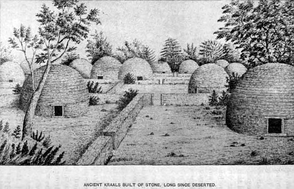
There are many extensive and valuable farms in the Marico district. Oranges, lemons, pomegranates, and all English fruit grow to perfection. Peaches are so plentiful that I have frequently fed the pigs with them. I am writing of the country twenty years ago, when not one-fourth of the population lived in the country that are now occupying the land. There was no town then; Zeerust, Jacobsdale, Lichtenberg, were not thought of. There were five Boers who possessed all the land round the country, and some of these farms contained 460,000 acres or 30,000 morgen; they were five of the Boers who fled from the Orange River sovereignty after Boomplaat’s affair, treked as far as Marico, where they divided the country between them, and which they or their descendants still hold. In this district are the ancient stone kraals mentioned in an early chapter; but it requires a fuller description to show that these extensive kraals must have been erected by a white race who understood building in stone and at right angles, with door-posts, lintels and sills, and it required more than Kaffir skill to erect the stone huts, with stone circular roofs, beautifully formed, and most substantially erected; strong enough, if not disturbed, to last 1000 years, as the walls and roofs of the huts were two feet in thickness, built of partly hewn stone. The divisional walls and outer wall were five and six feet in thickness, and at the present time five feet in height at places, the upper stones having fallen; and now large trees are growing through the walls. But in no case have I discovered any trace of mortar or any implements. Plenty of broken crockery is found in the ground when it is turned up, but none on the surface. Kaffirs have never been known to build their huts with stone, or make fences at right angles, everything with them is round; they will have stone walls round their huts, but nothing more.
There are extensive remains of ancient diggings to be found all over the country, which proves that at one time all this part of Africa has been prospected, and what favours this view is, that where there is a smooth natural rock exposed above the ground, extensive carvings of animals are cut deep into it, which nothing but a hard cold-chisel could make any impression on this igneous rock, that is as hard as steel, and which, I believe, were executed by the people who built those stone huts. There are also small furnaces still remaining in some of the remote nooks, out of the way of being destroyed by the people or oxen; but for what purpose they were made cannot be discovered, all we know is that large quantities of lead and copper are found in the neighbourhood; and close to them is a lofty hill in which are found thousands of perfect cubes, from an eighth of an inch to an inch square, which when broken show a bright colour between brass and gold, which, I conclude, is iron pyrites: they have a rich brown colour on the surface. Gold I have found in this locality when prospecting, which I well remember, as in consequence of a fall from a quartz reef I smashed a watch. I had occasion to go frequently to Marico, as there were many roads branching off in all directions—one called the river road to Mongwato, three to the Bechuana chief, others to Kuruman, the Colony, also to Pretoria and Potchefstroom.
Zeerust is about ninety miles to the west of Rustenberg; the latter is a small town surrounded by hills, and where some fifty of our troops were in a laager or small fort during the whole of the Boer rebellion. It is situated on the Hex river, a tributary of the Limpopo. About twenty miles south of Rustenberg, on the road to Potchefstroom, at Blaawabank, are gold-diggings, but it is not a paying affair. The country is wild and picturesque. Old remains of copper-mines are to be seen a little south of the town.
Forty miles to the east is Pretoria, the capital of the republic and seat of Government. It is pleasantly situated between low ranges of metamorphic hills that run east and west, and is south of the Magalisberg mountains seven miles. The city is built on an open plain, that gradually slopes towards the north, supplied with beautiful fountains that rise a few miles on the south of the town, the water falling into the Apes river. An isolated hill, about three miles on the east of the town, is a conspicuous object in the landscape. The streets run parallel; the market-square is open, with the Dutch church in the centre; there are several good hotels and a cathedral; Bishop Bousefield lives in a snug house, with very fine blue gum trees in front. Many large stores were erected during the British occupation; but at the retrocession the greater number were deserted, and a general exodus of the English took place, for it was impossible to live under the new state of affairs. The town in 1875 was not one-fourth the size it was when the Transvaal was returned to the Boers in 1881. Mr Burgers was then president, and he laboured hard to improve the country; but the people were not to be moved, and no advance in civilising them could be made. There was no money in the country, except a little English gold, everything was by barter until 1865, when paper money was issued, called bluebacks, to the extent of 10,000 pounds, and from time to time fresh issues were made to meet the expenses of the State. They varied in value, viz. in 2 shillings 6 pence, and 1 pound 5 shillings notes, but commercially the 1 pound 5 shilling notes were only worth two to three shillings. I had many of them, which I took at that price, and disposed of them for the same; but if you had to pay the Government tax the full price was allowed, for they could not refuse their own notes.
The country is open and free from any extensive wood, and the climate is suitable to produce every kind of vegetation. In the spring of the year the thick rose-hedges which divide the gardens give a very pleasing appearance to the town, when they are in full bloom. The extensive barracks and fortifications erected by the British Government on the south of the town, at a cost of over 100,000 pounds, have been made a present to the Boer Government for their disloyalty to British rule.
The Roman Catholics have a convent with several nuns, which at the outbreak of the rebellion was taken possession of and strongly fortified. The nuns and lady superior were placed in a corner of one of the buildings. All the rest of the establishment was taken, and converted into a kind of barrack for the volunteers of Pretoria, formed into four companies, of which I unfortunately belonged to Number 4, where we had to do sentry night and day. Our bed was a waterproof sheet on the bare stone floors, and as the convent swarmed with fleas of all sizes, from the heavy dragoon down to the light infantry, there was no fear of a sentry sleeping on his post. Every second night my company was ordered to occupy the interior of the convent during the night; each volunteer was assigned his particular post in the various compartments and passages, placing a sentry at different points, the rest to sleep—if the fleas would let them—fully armed, ready at a moment’s notice to defend our position. My post was generally at the entrance-passage to the priests’ quarters, which had been vacated by them, and on the bare stone floor I spread my waterproof sheet to get a little sleep; but the fleas, not one but millions, came down upon me in every quarter—poor things, they missed the nuns and the priests, for they were ravenous. Finding I should be sucked dry in a very short time, I took my rifle and sixty rounds of ball cartridge, made for the entrance, and passed the night on the door-sill, in about as happy a state of mind as a poor devil could be who had been marching up and down all day between the convent and the garrison. For fourteen days, from the 19th of December, 1880, to the 2nd of January, 1881, I had to put up with this sort of work, until I suffered so much from the excessive fatigue and want of sleep that I obtained three days’ leave of absence, as I felt unequal to the work and required rest; but at the expiration of that time I became dangerously ill from the overstrain on my system, and got a medical certificate which relieved me of any further military duty in Number 4 Company, and from that date to the end of the rebellion I lived in my waggon.
At the commencement of December, when we expected the Boers would make an attack on the town, all the males in the four wards of the city volunteered to protect the women and children in each ward, and as my waggon was outspanned in Number 4, I joined with the rest; but when the news came into Pretoria that the Boers, to the number of 1000, had been in ambush at Bronkhurst spruit for two days, waiting for the advance of a portion of the 94th Regiment from Lydenburg, which had been murdered by the Boers, a council was held, and on the 20th of December martial law was proclaimed, and all those who had formed themselves into volunteers to protect women and children were marched up to the barracks as regular volunteers. My waggon was drawn up to camp, and placed under the charge of the authorities during my soldiering.
The history of this rebellion has been so ably and graphically described by others, it will be useless for me to go more into the subject. I can merely state the first news of the British surrender that reached camp, of the war being concluded, and the retrocession of the Transvaal to the Boers, arrived on the 28th of March, 1881.
The principal portion of the Transvaal, north of Pretoria in the Zoutpansberg and Waterberg districts, is called the bush veldt, where most of the farmers living on the high veldt, between Potchefstroom and Pretoria, trek at the close of the autumn with all their family and stock, and remain the winter, where the cattle and sheep find warm shelter in the thorn forests; and return to their farms when the spring grass is sufficiently high for the stock to feed. The Boers make this trek a kind of picnic, and it is the only kind of life they enjoy.
This high land is also called Witwater rand; the elevation above sea-level is 5800 feet. Extensive seams of coal have been discovered about forty miles to the east-south-east of Pretoria. Roads in every direction traverse the country. The distances from Pretoria to the following places are: to the west, Rustenberg, 40 miles; north to Marabastadt, 160 miles; east to Middleberg, 100 miles; and to Lydenburg, 165 miles; south to Heidelburg, 55 miles; Standerton, 120 miles; and Newcastle, 190 miles; south-west to Potchefstroom, 110 miles; and to Kimberley diamond-fields, 334 miles. Middleberg is a small village on the road from Pretoria to Lydenburg, and the gold-field is in this district; a cobalt-mine has been discovered. Lydenburg is situated in the open country, on a branch of the Spekboom river. The country round is very hilly, some of them attain a height of 8000 feet above sea-level. The average height of the gold-diggings is 4200 feet.
The detachment of the 94th that was murdered at Bronkhurst spruit, for some months held possession of a small fort here, before they marched for Pretoria South of this town, some seventy miles, is a district called New Scotland, on the eastern boundary of the republic, which was in 1864 brought under the notice of a Mr McCorkindale for the purpose of forming a Scotch colony, but it fell to the ground. Klip Staple, already described, and the source of the Vaal river, spring from this locality. Wakkerstroom and Utrick have also been mentioned in the first chapter. The only portion requiring explanation in the district of Derby and Lunenburg, with its little colony of Germans who suffered great losses during the Zulu war.
Heidelburg is pleasantly situated on the south side of the watershed, containing many well-built houses. It was during the rebellion the headquarters of the rebels, and from which Captain Elliot was released and shot by the Boers when crossing the Vaal river. The road from Pretoria to Natal passes through this town, and also Standerton, another small town on the Vaal, and on to Newcastle. Standerton was also held by the British troops during the rebellion.
To the west of Heidelburg, seventy miles, is the town of Potchefstroom, the first town laid out by the Boers in taking possession of the country, situated on the Moi river; nearly half of the inhabitants were English, Germans, French, and other nationalities. It is 4007 feet above sea-level; there are some interesting limestone caves on the river, in which are imbedded many bones. The town is well laid out with fine fruit-gardens. Tobacco is extensively cultivated in the vicinity and all over the republic, and is well known for its fine quality.
Thirty miles to the west is Klerksdarp, on Schoon spruit, and to the north-west of Potchefstroom, seventy miles, is Lichtenburg, a village erected in 1868. There is also between these two the village of Hartebeestfontein. Potchefstroom from Kimberley is 224 miles. Following the Vaal down west is Bloomhof, a poor miserable village, and on towards Kimberley is Christiana, another poor and desolate place; they have been the rallying-points for the freebooters to attack the Bechuana chief. The whole of this division of the Transvaal is open and uninteresting.
Between Christiana and Lichtenburg is a farm called Gestop, situated in a very pretty valley, close to a picturesque hill. On the northern slope are some ancient carvings of animals on the rocks, which are composed of a close-grained kind of freestone; several of them are on rocks at the base of the bill, others half-way up, made no doubt by the people who made the others, the workmanship being similar. Up the valley by the side of the bill was, when I used to visit it, a favourite resort for the muscovy duck, and where I have frequently gone to shoot them, but they are most difficult to get near. The only way of getting a shot at them was to hide in the long reeds that grew on the banks of the stream and wait for them to fly over, which they did regularly about four o’clock in the afternoon, where they remained the night, and away in the morning to some other favourite locality. A few hundred yards from the farm-house is a stone or rather a kind of slate quarry. The stone is of a light colour, very soft; it can be sawn into any shape required, and is much used for grave-stones; slabs of any size and thickness can be obtained; it can also be used for mantelpieces, and any other kind of work. The hills and veldt on the farm have many valuable herbs, and two kinds of wild tea, equal in flavour to that from China,—in fact, I prefer it to the imported teas, and it is a splendid tonic.
The country round is more diversified with hill and dale, and thickly wooded with the mimosa and other trees and bush. Mr Van Zyl, who occupied the farm when I knew it, sold it some time after, and treked with his family and all his belongings out of the Transvaal to be free from the Boer Government, and went into the interior hunting, where the Namaquas robbed him of all his property, waggons, and everything, and shot him and his son.
A few miles to the north of Gestop are the famous salt-pans, and Barber’s pan, of which a description has been given, and a few miles to the south-east is Reid vlei, a pretty piece of water, a great resort of wild-fowl in those days long past. It is a wonder now to see a single duck; it is pretty nearly the same with the game. At that time they could be counted by the thousand, now it takes a long ride to meet with a few. I have had troop after troop pass in front of my oxen as I have been treking along the road, by the thousand, and not ten miles from this farm; and, as I camped out in the afternoon on the plains to remain the night, have been much interested in watching the old gnu-bull standing alone doing sentry duty, keeping guard over the cows and young ones when feeding a few hundred yards from him. He would always select an elevated piece of ground to have a good view round, and every few minutes he would change his position to all quarters of the compass, and the first sign of danger give several barks as warning to the others, and then, with a quick switch of his tail, head down, gallop off to his friends and remove them further away from any enemy that may be approaching.
In all these open flats there are always to be found large dried-up pans, all of them brack, which is very suggestive of sea-water. It is not only the pans but the entire soil that is brack, from one end of South Africa to the other, some parts more than others. It is only in small pools, or at fountains, where fresh water can be obtained. To one large dry pan, half a mile in diameter, and fifty feet deep, with very nice sloping sides, I gave the name of Chalcedony pan, from the immense quantity that covered the ground, not only round the pan but for miles in every direction; and on all these high flats, every variety of agate, flint, cornelian, and other kinds of every colour and form, as also splendid specimens of petrified woods, and in the stone hills, large shells, but empty of the snails, many of them beautifully marked, also small fresh-water shells of various sizes, and I have spent many pleasant days prospecting for some of these specimens.
Near Christiana, on the Vaal river, are two extensive dry brack-pans, the largest is two miles round. On the south side the ground forms a small hill with bush and trees upon it; this is between Christiana and Bloomhof, where there are several salt-pans a few miles to the north of that town, where a large quantity of salt is procured annually of good quality. The salt can only be obtained on certain occasions, which is very peculiar, showing there must be a vast quantity of salt below the pans’ beds.
These salt-pans are quite dry and free from water for some four or five months a year, when there is no salt to be seen, and it is not until the rainy season is over, and the water that has collected in the pans during that time (some two feet deep) has in the course of a few months evaporated, that the salt appears to have been drawn from the deposit below to the surface by the action of the water upon it, and a thick deposit is left, which is collected by the proprietor, and sold at various prices. I have paid for a sack containing 200 lbs. 3 shillings and sometimes 5 shillings, according to the supply and demand. Some salt-pans do not give a sufficient deposit to pay the cost of collecting. There is a great sale for it throughout the country; but table-salt is supplied from England, as there has been no means of cleaning the native salt from the impurities it contains. The Boers and natives use it. Some of these salt-pans will yield in the season nearly 1000 nuids of 200 lbs. each, and yet there appears to be no diminution in the supply, showing there must be extensive deposits beneath the pan beds. And so impregnated are some portions of these extensive grass plains that the grass that grows upon them is called the sour veldt, and other parts, where the surface-soil has been washed down from a higher level and deposited on the flats, is called the sweet veldt. The sour veldt is easily distinguishable by the white coating on the ground, which the oxen lick when they want salt.
I always kept my oxen in good condition by giving them salt, once or twice a week, from a supply kept in the waggon for them, and it is a great preventative also against that common sickness the lungsick, which is very fatal to oxen all through South Africa. There are several salt and brack-pans in the northern division of the republic, but the most numerous and the largest are to the south of New Scotland. Lake Cressie is the most extensive, in shape something like a horse-shoe, and nearly twenty miles round, lying in an open grass country with few bushes. The water in it is permanent, and cannot be very brackish, as a hippopotamus has been known to live in it since it was first discovered. The road from Lydenburg to Wakkerstroom passes on the east side of the head of Lake Cressie, where there is a store, and a more desolate-looking country to pass through is rarely to be found.
But Barber’s pan is the most picturesque of all I have visited; this also forms a kind of horse-shoe in shape. The outer banks are high on the west, with bush and trees; the inner side is much lower, and thick bush, and was always a favourite place for outspanning, and remaining a few days for duck-shooting—and also the black and white geese, being a secluded spot, seldom visited by the white or black man. Game as well as birds could always be obtained, and plenty of wolves also. In circumference it must be some fifteen miles. A few miles to the north-east is another extensive pan, long but narrow. They both hold water all the year round, as they are deep.
At Wolverfontein, where Mr John Dunn has a pleasant farm situated near the eye of the Moi river, upon which Potchefstroom is built, I visited the limestone cave, which Mr Dunn pointed out to me. This cave passes underground for several hundred yards, and terminates at an underground river, which flows to the north-east in a great stream, and is supposed to come out at the eye of the Moi river, three miles away. Close to the cave, in the high lime formation of a light-brown colour, the rock is composed of one-half bones, teeth, entire jaws with the teeth in them, belonging to some large animal, mixed with quartz rock. It is a strange fact to find quartz so intimately mixed up with this limestone and bones. I collected several fine specimens of bone imbedded in this quartz and limestone mixture. One of the specimens of part of a jaw I measured in situ. The bone, in which the teeth were perfect, measured twelve inches, perfectly straight, sharply pointed at both ends, and one and a quarter inch in the broadest part; the shape being exactly like a canoe or some of the fast river-skiffs. A single row of eight teeth down the middle, two of the centre ones being the largest, nearly an inch square; the other three on each side were smaller, until the two end ones measured a third of an inch square; they may have belonged to a ruminant animal. The peculiar form of the bone the teeth were fixed in I thought singular. I procured four similar specimens, two of the same size, and two smaller, with several other pieces of rock, half limestone, half quartz, in which are many perfect specimens of teeth and bone.
Over this interesting deposit there is a large wood with limestones cropping up above the soil. Upon one of them I saw several loose egg-shaped stones, and others perfectly round, the size of a sparrow’s egg, lying on the ground close to the rock. On stopping to pick them up I found the stone full of them, some half buried, others only holding by a small part of the ball fixed to the rock. Thinking it a very interesting specimen I went to my waggon for a hammer, and secured one of the projecting parts of the rock that had some of these balls imbedded in it, and a dozen of the loose balls, which have been carefully preserved to be examined by a geologist when time will permit, to ascertain if this singular formation is limestone or not, as every portion of this limestone formation is black except where the bones are found, and there it is of a light-brown colour. It is also found in all the dark rocks in the same locality. Extensive tracts of country in South Central Africa have similar rocks containing crystallised globules, which when broken are hollow, which leads me to suppose this rock is not a limestone formation. Dr Lyle, the geologist, at Pretoria, examined the rock with bones in it, and pronounced it a kind of lava impregnated with lime from the bones.
In the neighbourhood of Lydenburg, to the north, are many extensive caves, some extending for nearly a mile underground, that have been formed by the small stream of water that flows through most of them, with beautiful stalactite hanging from their roofs and sides. A short distance to the west of these were the strongholds of the chiefs Secoeme and Mampoer. These mountains are completely riddled with caves, and are places of great strength, and surrounded by many Kaffir kraals, under several petty chiefs. The most noted are Magali, Manpartella, Secocoene, Matebe, Maselaroon (Queen), Mapok, Mamalube, Umsoet, Moripi, Umlindola, Majaje (Queen), Maffafare, Mayaya, and others, numbering many thousands in all. During the Secocoene war, in 1878, I was through that country, travelling up from Pretoria with a detachment of the 80th Regiment, and visited the magnet heights, a range of hills composed entirely of loadstone of highly magnetic power. It is about forty miles to the north-west of Lydenburg.
The area of the present Lydenburg gold-fields may be included within a radius of 100 miles from that town, and contains some of the most magnificent scenery in Africa. Within it are the hot springs, six in number. They are situated among rocks, and close to them is one cold spring; they are becoming known as having very healing properties. The Komati river passing between beautiful mountains is most picturesque, and on the north the Waterfall river and other streams have lovely scenery, with the lofty mountains forming the background. A most charming effect is produced when the clouds are passing along their sides below their summits. It is a pity that a land so lovely and so rich in valuable minerals is not in better hands, where a firm Government would be able to properly develop the country. There are at present a few thousand people living near the various diggings, but many say they are not succeeding. Large sums of money have been expended in machinery, but few companies pay.
Before leaving the Transvaal I wish to call attention again to the white Bushmen, described in the early part of this work, which I omitted, viz. that they are only found in the mountain ranges on the west of the Drakensberg, and in that mountain. They have never been found in the lowlands or in any other part of Africa, and are distinct in form; that is, so remarkably thin, and their legs being more like sticks, without any appearance of a calf, pot-bellied to an enormous extent, with their spine curving in like a bow, and few exceed four feet in height; their colour is yellow white, quite as much so as Europeans brought up in a tropical country. This leads me to conclude they are a separate and distinct race, unless they are part of a tribe that live in Equatorial Africa, called the Akka or Tikku-Tikki race, under the king Munsa, the pigmy race described by Herodotus; but these appear to be of a much darker colour. When travellers state the age of any of these peculiar people it cannot be relied on, for I do not believe there is a black man in Africa who knows his own age. I have seen some exhibited whose age is stated to be twenty; this is mere guess, for it is impossible to tell, when they have no notion themselves whether they are five or fifty.
Chapter Nineteen.
General remarks on the Transvaal.
The two main roads from the Cape Colony to the Transvaal cross the Orange river at Hope Town, and a few miles north of Colesburg, both meeting at Kimberley, the diamond-field centre. Railways are open as far as Kimberley.
From Kimberley to Pretoria by road is 334 miles. The country, the whole distance, is open, and most uninteresting; grass-lands the entire distance, broken here and there with small patches of low mimosa bush. The only portion of the distance less monotonous than the rest is the road that skirts the bank of the Vaal river, as far as Bloemhof, where the pretty wooded banks and broad river relieve the eye from the everlasting rolling plains seen in every direction.
There was some pleasure in travelling these roads twenty years ago, as game being plentiful on the veldt, and wild-fowl of every kind in the rivers and pans, there was some excitement in looking out for a good dinner. At the present time I have travelled from Pretoria to Kimberley and never had occasion to take my gun or rifle out of my waggon.
The face of the country is entirely changed, farms now occupy the land, and many villages are built, supporting a considerable population that depend greatly for support by supplying the several markets on the fields with their produce. In all my experience of African travelling, I never passed through a region less interesting for picturesque scenery than the greater part of Griqualand West, and the southern portion of the Transvaal, up as far north as Lichtenburg and Pretoria. But it is not so on the eastern border and northern division of the Transvaal, where is fine mountain scenery and thickly wooded valleys, with the many rivers, the banks of which are clothed with thick vegetation, with timber of considerable size and variety covering the country in all directions. The Pongolo forest near Swaziland; the finely-wooded district of the Lobombo mountains; the wild region north of Lydenburg to the Limpopo river, an extent of country some 150 miles in length; and all to the north of the Magalisberg range, where the forest is more dense, containing much valuable timber; right up to the northern boundary, separating this republic from the Mashona or Matabeleland by the magnificent Limpopo river, a region extending 200 miles in length; more particularly in the northern division, where the unbroken range of forest that covers each bank of this noble river for hundreds of miles on the right and on the left, where the abrupt and almost perpendicular mountains rear their lofty heads far up in the clouds, clothed with every kind of tropical tree. This gives one an idea of eternal spring, the foliage displaying a charming variety of every shade and hue, from the pale and silvery to the darkest green and copper-purple; much of it covered with a profusion of lovely lily-like flowers, others with crimson bloom, fruits and seeds, creeping plants climbing to the topmost branches, and falling down in graceful festoons to the ground, forming numerous ropes, which the many monkey tribes use to ascend and descend with remarkable speed. Some of the giants of the forest—the noble baobab and others—blasted by storms and age, stand out in grim mockery of perpetual life, although they may number many thousand years, noble emblems of misfortune and decay.
“The rheum of age from Marlboro’s eyes to flow, And swift expire a driveller and a show.”
In some of these African forests, so extensively covered with timber and beautiful underwood, where the white man’s foot has seldom trod, it is natural to look for some rare specimen in animal or vegetable life.
There is a charm in traversing these unknown forests that irresistibly draws the explorer on more into their recesses. The gloom pervades everything around, cut off from the bright sun above by the dense foliage, casting into shadow the gigantic boles of many trees that surround the traveller, giving a weird aspect to the scene, combined with the perfect silence that reigns around; for during the greater portion of the day, when the tropical sun is high, all nature is as it were dead, the birds retire into their homes, the wild animals crowd into some hidden nook and sleep, and everything is at rest, until the sun nears the western horizon, when one by one, both animals and birds begin to stir. A single antelope may be seen leisurely moving along, then two or three more; a jackal, a tiger-cat, or some other beast of prey makes a cautious advance among the bushes; the distant sound of branches being broken by elephants or giraffes; the twitter of many birds, and the shrill whistle of others calling to their mates, cooing of doves, and the tapping of the woodpecker on the decayed bark of trees seeking for insects beneath (which has a most peculiar effect upon the listener in the silent retreat), and as night advances, the roar of the lion, which startles all nature into silence, causes the intruder upon his preserves mechanically to look to his rifle to see all is right and fresh cartridge handy, for at any moment his proximity may be expected.
It was on one of these evening rambles in the noble forest that I was an eye-witness to a very rare and singular sight, and which, I believe, few explorers have ever witnessed.
Wandering on where the openings in the bushes allowed free access between the thick vegetation, admiring the splendid picture of vegetable life, I caught the sound of loud, deep, bass voices not so very far away, which appeared to be coming nearer. As I was under one of those splendid baobab trees, quite in shadow, I determined to wait and find out the cause of such unearthly sounds. Lying down on the grass, to be out of sight as much as possible, I waited with my rifle ready for action, if any animal should come disagreeably close. The sounds were continuous, and became louder every moment. At first I concluded there were several wolves fighting; then growls, similar to cats on the house-tops, but much louder; this continued for some twenty minutes. Crawling round the tree on my knees, I discovered the cause. About seventy yards from where I was concealed were two lions, that is, a lion and a lioness, apparently in a very quarrelsome mood, as the lioness kept throwing back her ears and showing her teeth, at the same time pawing the lion in the face with her huge paws, and lashing out with her tail, the lion taking it very quietly, but growling as if remonstrating. All this time they were coming nearer, until they stopped some forty yards from my retreat; all was quiet—I intently watching them all the time—for some ten minutes longer, when the lioness gave a few cat-like spits, and bounded into the bush, and the lion quickly walked off in another direction. A hunter relates being once in a tree watching a lioness and a lion. Another began roaring in the distance, when the lioness roared in reply, the lion trying to prevent her. But at last he began also, when the other lion appeared, and a terrible fight began, their strong bones cracking. At last the first lion was killed, and the lioness, with a whisk of her tail, went off with the last. “Oh, you jade!” said the hunter.
Evening was now falling fast, and as the nights here close in soon after sundown, it was time to strike for my waggon, where I had outspanned on the banks of the river, at a very pretty bend, where I could get plenty of sea-cow and crocodile shooting. On my way home, which took twenty minutes to reach, many kinds of game crossed my path, and I managed to bag a fine silver jackal. The lion and lioness were not seen any more.
My camp is 100 yards from the river, where several openings in the trees give me many pretty glimpses of the stream and the opposite bank, which is, from this near side, some 200 yards broad, with several sand-banks and rocks in mid-stream. Lofty reeds grow thick and strong upon their sides, full of nests belonging to the yellow and red finch, as also the larger kind with long black tails that greatly impede their flight.
Birds of all sizes, and of many colours, with brilliant plumage, swarm along the banks; several kind of kingfisher, honey-birds (not much larger than hummingbirds, with their long curved bills, mostly found where flowers are plentiful), bitterns, pelicans, Kaffir-cranes, flamingoes, geese, ducks, and other kind of water-fowl are seen in great numbers, and give plenty of occupation for rifle and shot-gun. The vultures, hawks, and eagles are daily seen on the wing. We stumble on snakes at every turn of the forest and along the river-bank. The python has been killed on the Limpopo, the natives tell me, longer than my waggon, which is sixteen feet, and some say that there are others that have been seen double that length.
About a mile below this camp I came upon their spoor, in the long grass, and from the beaten path they made, over two feet in width, there must be many of these monsters about. We have been out several times at night to look for them.
The largest snake I shot, next to the python, was when walking along a bank of sand, where there were several large holes. He was moving in the grass a short distance from me, a most vicious-looking reptile, quite black, and measuring nearly thirteen feet; there are others nearly as large in the Kalahara desert. I have killed many puffadders, but none exceeded in length three feet six inches. The long, thin yellow snake is mostly found in trees, after birds; they stretch themselves along the branches, and look like a portion of them. Those I have killed measured nearly five feet. When the little birds see them they fly round and near, making a great noise. I was walking along a river-bank that had several snake-holes in it; a short distance ahead was a small bird fluttering about in one spot. Standing to watch it for some time, and finding it still kept on in the same way, I walked up almost close to it, when I saw the head of a large snake sticking out of a hole; but on my making ready to fire he retreated into it, and the bird flew away. This was the first time I had seen a snake charm a bird. The variety I have killed may be called legion. Of several the names are unknown.
The iguana grows to a large size in these rivers; I have only seen the black one in this district. My boys killed one measuring five feet seven inches; they cooked and dished him up for their supper, and told me it was very good. The hedgehog, ant-bear, and armadillo are plentiful, as also many kinds of earth-animals, generally found in the more open parts. But the most disgusting thing, and which I have a horror of, are those tree-toads. Some trees seem to swarm with them; they fix themselves in the fork of a branch, and remain quite still all day, and at night they chirp like a bird—it may be called the singing-tree, I suppose the same kind mentioned in ‘Pilgrim’s Progress’—their colour so resembles the bark that it is difficult to distinguish them from it. I have stated in a former chapter that several dropped into my waggon when on my way up to Matabeleland.
Early the next morning, after my lion adventure, I prepared for a day’s shooting up-river, ready for any and everything that came within range of our rifles. My driver and a Cape boy, both very good shots, and myself with shot-gun, after an early breakfast, started soon after sun-up along the right bank of the river. We had not proceeded many hundred yards before a large flock of guinea-fowl flew up, when both barrels brought down five. This was a good beginning; they were sent back to the camp at once. It is no use pursuing these birds when they have been disturbed, they run like a race-horse, and keep to the ground. If you have a good dog to chase them they are compelled to find shelter in the trees, when they can be shot. My last dog was bitten by a puffadder and died.
Continuing along the bank for some little distance I came upon a deep pool in the river, where we could distinguish, just out of the water, part of the head of a large hippopotamus; but as we neared him to get a shot he prudently sank. On the opposite bank two half-grown crocodiles were enjoying the morning’s sun, and they also thought it desirable to clear for the water, but not before one of them received a bullet in the side, which made him turn and twist about, lashing his tail as he made for the water, where we lost sight of him. The river was too wide and deep, and too dangerous for any of us to cross, to attempt to follow him up; but we saw by his motion in the water he must have received a mortal wound. The river appeared about 200 yards wide, with thickly wooded banks, and fine timber trees. As we were watching his movements, several ducks flew past down stream; two I shot, but they fell in the water, and no one dare go in to get them, as our friends the sea-cows and crocodiles might lie there. Consequently, we left them floating on the water, but had not moved many paces away before they had disappeared, a dainty morsel for one of these monsters.
As we advanced along the bank we became aware that large game occupied the other side of the river. The dense forest prevented our seeing them, but there was no mistaking the sounds. Elephants were near, by the breaking of branches and the constant rumbling sound of their bowels. The river was too deep and dangerous to cross, therefore I had no choice left but to remain quiet and concealed in the shadow of the beautiful trees, the branches of which overhung the river. We knew they were approaching the river to drink. After waiting some twenty minutes, one by one they pushed themselves through the undergrowth that lined the steep bank, and made for the water, standing in a row close together, sucking up with their trunks the water into their immense throats, an operation that looks ridiculous, a sight seldom to be seen in daylight. To have fired upon them would have been cruel, as there was no possibility of getting their tusks even if we had killed them; we therefore watched with intense interest this interesting sight.
After satisfying their thirst, they walked into the river until they were half submerged, throwing water over their backs, and flapping their immense ears against their sides, making a peculiar noise, evidently enjoying the bath immensely, pawing the water with their huge legs; and then returned to the forest, to browse on the young and tender branches of their favourite trees. There were thirty-seven full-grown, and eleven young ones of various sizes. It was with difficulty I could restrain my boys from giving them a shot. To see elephants, the largest of all animals, in their native wilds roaming undisturbed, and note their habits and actions, is most interesting.
These gigantic animals care very little for crocodiles or hippopotami; but the rhinoceros often kills them. Their long legs, being six feet in length, and nearly three feet round, are very formidable when used in their own defence, either on land or water, without the aid of their five feet of tusks. At the present time these splendid animals are never seen in these parts, where formerly they were so plentiful. Mr John Viljoen, the Boer who came north after the Bloomplaats fight in 1848, thirty-seven years ago, and settled in Marico, told me that the whole of that district swarmed with elephants and every other kind of large game, as also in the neighbourhood of Rustenburg, Pretoria, and other localities more south; now they are seldom seen south of the Limpopo, except in the country to the east, under the chief Umzela.
In the trees on the opposite shore, and in the forest behind us, large grey monkeys, with black faces, were busy watching us. There appeared to be hundreds, and as they swung from branch to branch, with the young ones following their mothers, they made the forest look lively. They travel on the tops of the trees faster than you can run below.
As it was now getting on towards noon we pushed on up-stream, making excellent bags of guinea-fowls, pheasants, and ducks. In addition to this dainty food, my boys shot a quagga, which the black man prefers to any other game. It was now time to return, being pretty well loaded with provisions to last several days; but what avails that with a hunter, when surrounded by so many tempting opportunities of having a shot at animals or large reptiles, never to be met with out of these primeval forests? We wanted sjamboks, so much sought after by the colonists; the best are made from the skin of the hippopotamus, so we must bag some, if possible, before we left this fine and undisturbed hunting-ground.
We therefore searched the river carefully on our way back, directing the Kaffirs to peer into every nook and corner of the pools, and at last were rewarded by discovering a fine, large sea-cow moving about in long reeds in a small sand-island, only separated from the bank by some twenty yards of shallow water. This was a splendid chance not to be thrown away, as he was quietly feeding, unobservant of our presence. We took advantage of his turning towards us, and gave him three shots in the head, one entering the brain, and he fell without apparently a struggle; a most fortunate and lucky capture, as he was on a bank just above the water, where we could take his skin and tusks without any trouble. Slipping off my boots and socks, I tucked up my trousers, and was soon at the beast’s side. It occupied us the remainder of the day, until sundown, to take the skin, which was no easy task, and even then we did not secure the whole; only taking the best part, suitable for the renowned sjambok, and several pieces of the flesh, as it is excellent eating, similar to pork. It was now a puzzle how to get all to the waggon, being nearly a mile from it. I therefore determined to send all my three Kaffirs with as much as they could carry to the camp, and return with some empty sacks for the remainder, while I remained on guard.
It was some time before they returned, the sun had long gone under, but the bright starlight night enabled me to see distinctly some distance round. During their absence I enjoyed the perfect silence that pervaded everything, except occasionally the splashes in the water by crocodiles at play, or in their rush after fish, and the blows of the hippopotamus as it came up from the deep water. Not a breath of air stirred, or a leaf moved. Numerous fire-flies added a charm to the scene, for they are most brilliant, and even give light enough when caught and held near a book, in the darkest night, to read distinctly. Many glow-worms, of which there are legions here, will also give light to read from. We now set to work to cut up more of the sea-cow’s flesh, and after well loading all hands, started for the waggon, where we arrived about eleven o’clock in the evening, after a hard and an exciting day’s work.
Lions we heard from both sides of the river as we made for camp; also wolves and jackals, with the plunges in the water from the sea-cows, as we disturbed them in passing, where they were feeding along the bank, kept us on the alert from a surprise.
From a long and isolated life in the wilds of Africa how sensitive the hearing becomes to sounds of every kind, and the different calls or notes of birds or beasts, if danger is near! Birds will give warning much quicker than animals, from their being able to see a greater distance from the branches of the trees. Animals know the birds’ call of danger, as also do birds that of animals. The plover is the most annoying to a hunter, as they are persistent in following him up, giving the note of alarm. I have endeavoured to hide myself away many times from them; but they are not to be baffled in this way, but come flying round the bushes, prying everywhere, until you are discovered, and with renewed vigour they strike up their alarm-notes, making the game fly before you in every direction. Once let these birds fix their attention on a hunter, he must either shoot them, or give up hope of a good day’s sport.
The boy in charge of the waggon during the day informed me that a little before sundown nearly a hundred head of game had passed down the river, close to the waggon, but cleared when they discovered the camp. They were, from his description, the rooi or red antelope, the size of our fallow-deer.
We left this camping-ground the next day, and as there were no roads, had some difficulty in pushing our way through the forest, to avoid the tent of the waggon being smashed by the low branches of the trees. After proceeding some few miles we came upon the remains of a quagga that had evidently been killed and eaten by the lions the previous night, as their spoor on the sand was very fresh. We therefore hastened our departure to get clear of the dense bush before night, and after two inspans arrived at an open space close to a small brook of running water, where we fixed our camp for the night.
The weather is delightful, almost perfect; perpetual sun, which becomes monotonous when there is so much of it, scarcely sufficient wind to stir the leaves of the trees, the heat most agreeable, only 83 degrees in the shade at mid-day. After making all fast we prepared for supper: a guinea-fowl for myself, and quagga steaks for my boys, and then to bed at 9 p.m. During the night jackals and wolves annoyed us; lions we heard at a distance, but sufficiently near to cause us to keep a watchful guard in case they felt disposed to make an attack on our oxen.
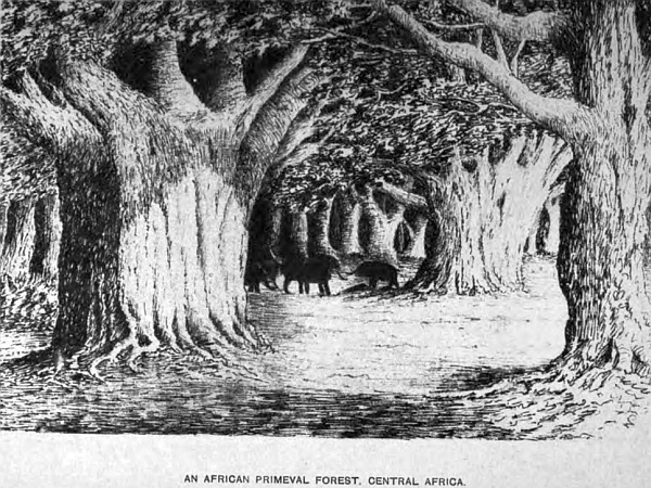
These grand old forest regions of Africa are full of interest, more particularly at the present season, when animal and vegetable life are springing into existence. Spring has far advanced, and summer is coming on apace. The birds are filling the woods with their notes,—although they do not sing they make the air ring with calls of many sounds, teaching their young to fly; the mocking-bird being the most persistent in keeping up his incessant chatter. The grey cockatoo, with his beautiful crest, is determined to make himself heard amidst the din of sounds; but of all the African birds I love, the best is the gentle ringdove; his welcome cooing notes have cheered my heart in many a weary day’s trek over a dry and parched-up region, where days have been passed without tasting a drop of water, when the notes of the ringdove have caught my ear, telling me water is near, for they are well known never to be far from it, which in every such case has been true. The croaking of frogs also is a welcome sound, for they never enlighten the air with their notes when the water has dried-up. Crickets and many other insects make the air ring with their chirps when water is plentiful.
A traveller, when roaming through this wild region, soon becomes acquainted with all forest sounds, and in many cases from necessity, when passing through a country where for six or eight months of the year rain never falls, not even dew, to moisten the atmosphere. During this dry time few insects are seen, but in the rainy season they swarm, and birds are scarce far from water; but along all the river-banks some with most beautiful plumage are to be seen, and many other kinds. Gorgeous flowers are not wanting to add beauty to the forest scenery, and a traveller must indeed be callous to all that is beautiful in nature who can traverse these woodland regions unobservant of their beauties. The charm lies not only in the magnificence of the scene around, beautiful as it is made by the Creator for man’s enjoyment, but it is also the book of nature, where man may learn wisdom away from the busy world. However much we may like the society of our fellow-man, there are times when it is very refreshing to be alone to think, particularly when surrounded by scenery rarely to be found out of these splendid old forests, where nature has been so bountiful in clothing the earth with such pleasant objects to look upon. I love the woods and their surroundings, where the mighty baobab, the king of the forest, reigns supreme above all other trees, whose age exceeds 5000 years, and is yet full of life and vigour—born a thousand years before the great pyramids of Egypt were even thought of—a living monument of the vitality of nature. Mighty nations have grown, flourished, and passed away into oblivion, since these vegetable monuments first took root, where they now stand and flourish, fit emblems of man’s littleness. We pace the galleries of our museums and look with admiration on those monuments brought from Nineveh, Babylon, Greece, Rome, and Egypt, which speak of the past history of the world, but not one of which can date as far back as these living trees, that had life before these nations had an existence.