"Sport and Travel in South Africa" (continued 4)
Reading edition
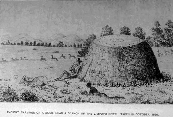
On one of the tributaries of the Limpopo is a circular rock in the veldt, no other stones near it, fifteen feet in diameter, and similar in shape to a ball cut through the centre, and placed on the ground, only it belongs to the rock beneath the soil. This rock has been covered with carvings, the greater portion of which is nearly smooth by large animals rubbing against it, giving it quite a polish. Sufficient lines are left to show it has been well cut with some sort of figures, and on one side where it curves in a little, and is out of the way of elephants, rhinoceros, and other animals, the carvings are nearly perfect. They represent paths with trees and fruit on each side; upon one is a snake crawling down with a fruit or round ball in its mouth, near it is a figure, and a little distance off another figure with wings, almost like an iguana, flying towards a man who is running away; his left foot is similar to that of a horse, the right one has two points—evidently Satan; the intermediate spaces have many stars. The upper part of the stone has, in the centre, a small hollow of a cup-shape, with two circles of the same round the centre one. It is a very interesting monument, and appears to be very old, from the fact of the other portions being partly obliterated by the rubbing of animals against it. The rock is very hard and similar to those geologists call igneous. There are many rocks of the same description, with carvings of animals, snakes, and figures on them, and from their position they have been preserved from animals defacing them. In several parts of the country many of them are well executed.
A few days previous to my arrival here in 1877, three Boers, with their waggons, were endeavouring to find a new drift in the Limpopo river, and went in to cross to the opposite side. They had nearly reached the bank, when the foremost looked round and saw a large crocodile come up from the water and seize the head of the last man between his jaws, and disappear with him. His name was Herman, a married man, twenty-six years of age. Nothing more was seen of him but blood in the water. His widow, a few months after, consoled herself with another husband. At this time, soon after the British Government had annexed the Transvaal, the Boers, wherever I met them, were always friendly—so much so, that I have often been invited to take one of their daughters for a wife. They were rather proud to have an Englishman for a son-in-law. I was outspanned not many weeks back at a very pretty pool of water, or spring, the water of which fell into the Notuane river, in what is termed the Bush Veldt, that I might have a little shooting. The second day an old Boer and his wife came to me to ask if I would buy some ostrich feathers, taking me to be a trader, for all Englishmen travelling through the country will do a little in the way of barter; therefore I told them if they were good I would. When coffee was handed to them as a matter of custom, they asked where my wife was. On stating I was single, the old vrow said I must have one of her daughters; she had two mooi (pretty) girls, and would bring them the next day for me to see when she brought the feathers. Accordingly, the next day, true to her promise, she came with the old man and her two girls to the waggon; both very young, the eldest not more than seventeen, and not bad-looking for Dutch girls, apparently very modest and shy, with a conscious look of what they were brought for. After settling about the feathers, the old mother pointed out her daughters to me, and told me, pointing to the eldest, she would make me a mooi vrow, and that she had a farm of her own and some stock. Both the girls, sitting together by their mother, looked down and giggled every now and again, giving me sly glances from beneath their cappies (the usual covering for the head for old and young), and then another giggle. They had evidently been got up for the occasion by their smart dresses, well-made English boots, and clean white stockings, to show off a pretty foot and ankle, which certainly they both possessed, and were not backward in showing. This is very unusual, they generally have clumsy feet. When at home these articles are never worn, only leather shoes called veldtscoons, which the men make. They say—which is quite true—that stockings are dirty when you walk about in a sandy country. However, after a long visit, coffee and biscuits, I arranged that on my return I would come and pay them a visit, and talk over the matter, as my opinion was either of them would make excellent vrows, and left the best of friends. The old woman’s last words were, “You can take my daughter as soon as you come for her,” and an encouraging glance from the daughter terminated this interesting meeting, enhanced, as it was, by the anticipation of having the felicity soon to possess so charming a young lady. I have had many such offers from Boers, who were favourable to Englishmen at that time. However, unfortunately my pursuits called me in another direction.
The country between the Limpopo and Ba-Mangwato, the chief Khama’s station, is very pretty, plenty of guinea-fowls, partridges, and pows. Far away from the road on the left, seven miles from the bend of the Limpopo, is a large pan where lions are always known to be, and beyond is Brakwater, where ten years before I lost an ox from out of my cattle kraal one dark night when outspanned. It is the custom, with all travellers when in the Lion Veldt to kraal their cattle at night. Seventeen miles beyond Brakwater are the Khamitsie Pits, where water seldom fails, and close to them is a large dry pan quite a mile in length. The road passing round at the upper end, and fifteen miles beyond, winds through the veldt into the ancient river-bed leading to Mongwato. The whole region for hundreds of miles is one continuation of wood, inhabited by a few Bushmen. The country for so many months without water is uninhabitable, except at the springs. The distance by this river road from Molapololo to Mongwato is 164 miles.
Ba-Mangwato, or Shoshong, is the chief town of Khama. The chief Sekomo ruled at this station, until Machin, his brother, drove him from the chieftainship, and at Machin’s death, after considerable fighting, Khama, son of Sekomo, became the chief of the people over this territory. They belong to the Bakalihari tribe of the Bechuana family. It is a very important station, situated at the foot of a long range of beautiful hills, and up an opening in the range, where an ancient river-bed passes through, and where the mission station and church are situated, it is one of the most romantic valleys in this part of the country. When I first knew the station, the Rev. Mr Mackenzie had charge, now the Rev. Mr Hepburn lives in a very comfortable house up this kloof. The hills are formed of various kinds of sandstone of a brown colour. At the back, some distance beyond the church, is a very singular hill, with a perpendicular cliff on the upper portion. The stratification makes it look like a regular wall, with its horizontal layers so regularly placed. In Sekomo’s and Machin’s time the town was much larger, but since the wars it is considerably diminished. The chief Khama lives in the lower town, and has only one wife, being a good Christian and a great help to the missionary. The traders’ stores are also in the lower town, and form quite a little village by themselves. Messrs Francis and Clark have a fine store, and a building which is occasionally used as a concert-hall by the traders, who sometimes muster in considerable numbers, and out of so many a good band is got together. Most of those stationed there are splendid musicians, both vocally and instrumentally, so that many an enjoyable evening is spent to break the monotony of a life so far removed from the outer world. They have also their cricket matches, horse races, lawn tennis, football, and other sports. Mr Hepburn is indefatigable in his mission labour in civilising the natives, combined with the good example set them by the traders at the station. The chief Khama is a gentleman in every sense of the word. I have met him and felt much pleasure in his society. He has prohibited spirits being sold to his people, and on my last visit but one he did me a great service, and helped me in the most kind way by taking charge of my oxen when I had been two days without water, having arrived at Mongwato expecting to obtain some, but there was not a drop, not sufficient even for the people. On hearing of my arrival, he came down and took my oxen in his charge, sent them with one of his herds to his cattle-post eighteen miles away on the river Mokalapse, to the north of the town, and kept them there for twelve days, until I could trek to Matabeleland. He requires all travellers who enter his territory to call upon him, that he may know who is passing through, in case they require any help he can give. Those who avoid doing so, if they get into trouble, must get out of it the best way they can. All the roads from the south meet at Mongwato; one goes to Lake N’gami, another to the Chobe, two to the Zambese, and one main road to the Matabeleland, with branches leading to the Victoria Falls.
The people at one time were very unruly and troublesome to travellers. In 1868 I was at the station when a trader came in with some brandy; we outspanned close together outside the town. The next day the traders at the station, and there were some fourteen, indulged too much; one in particular had so far forgotten himself as to take a leg of pork to the kotla or council enclosure, where the chief Machin was sitting with his councillors, and held the leg of pork in the chief’s face, and asked if he liked the smell. These Kaffirs are like the Jews with respect to pork. This created an uproar in the station; the trader was severely beaten, and the whole town turned out to kill all the white men. They, hearing of this, fortified themselves in their stores. Hundreds of Kaffirs paraded the town, visiting the waggons with their knobkerry and assagai, threatening destruction to all the white men. The course which I thought best to take was to sit on my front waggon-box and smoke my pipe; time after time hundreds surrounding my waggon, raising their assagais as if to hurl them at me, and brandishing their kerries. Knowing the Kaffir character pretty well, I went on smoking as if they were most friendly, and seeing they could make no impression, they rushed away to other parts of the town. At last the chief sent round some of his councillors to all white men, ordering them all out of the town, bag and baggage, by four o’clock the next day. Mr Mackenzie, the missionary, left the day before to go to England. Not having anything particular to do, I, with the trader who came in with me, inspanned in the evening to trek towards Selene Pan, forty-five miles on the road to Molapololo, which we reached the following afternoon, and all that night and the next day traders came treking in, until thirty-six waggons had assembled and nearly fifty span of oxen, which looked more like a commando than traders flying from the wrath of a powerful chief. It was a very pretty sight. The man who committed this insult was too ill to be removed, and was left behind. He recovered, and, I think, became a wiser man. If it had occurred a few years before, he would have been killed, and the traders also. He richly deserved the punishment he received. This will show that the Kaffirs at that time had been brought under great control, for no greater offence could be given than an insult to their chief. Some little time after this affair, the chief, when solicited, allowed the traders to return.
The chief Khama dresses well, and looks like a gentleman. Many of his people also dress, as well as the women. They are strong and well-made; some still wear their skin dresses and a profusion of beads and brass rings, but I think in a few years these will be abandoned for European clothes. Begging is still largely practised, particularly for tobacco. They cultivate corn, mealies, pumpkins, melons extensively, and have large herds of cattle of all kinds, which are kept at the different posts away from the town, and milk is brought in on pack-oxen to those who have no cows. They also make Kaffir beer from their Kaffir corn, and, if well-made, it is very nice. This is the only extensive interior trading-station in this region. There are other trading-stations beyond: at Tati gold-fields, and in Matabeleland, and also at Pontarnatinka, where Mr G. Westbeach has a large store, and others beyond, and also on the north side of the Zambese river, where a large and increasing trade is now being carried on by the English traders at the chief Secheke’s on the north side of the Zambese.
The main direct road from Molapololo to Mongwato runs north-north-east through a bush country with fine trees. The distance is 133 miles, and very pretty, the formation being argillaceous limestone; most of the hills are sandstone. At a fountain at Koopan, twenty miles on this road, are some large masses of sandstone rocks, standing out like walls of an old castle that cover an extensive area. In these rocks are many fossil remains of seeds, nuts, shells, ammonites, and one trilobite, also footprints of animals. As it was impossible to obtain them, I remained two days to make correct sketches and measurements, being most interesting specimens. In many parts of the interior, where this light sandstone has been exposed by denudation, particularly in the deep beds of those dry rivers in the Kalahara, footprints are very numerous, which I have taken great care to copy, and also all the carvings on the rocks. The other permanent waters on this road are Bartlanarme in the chalk-pits, and Lepepe; also Selene pan. Both are favourite localities for the giraffe, and here I have remained several days to hunt them, and was fortunate enough to shoot one out of five that were coming to drink. Eight miles from Bartlanarme we shot two out of seven, and at another time Mr Hume, of Port Elizabeth, a hunter, came upon several, and shot three from the saddle, from my horse, which I lent him. One we had brought to the waggon, and left the other two for the Bushmen. The flesh is very fine. It is a pity such beautiful animals should be destroyed merely for food and skins. In this part almost every variety of game is to be found. Such a vast extent of open country—where the white man is never seen beyond the transport road, and its inhabitants Bushmen only,—extending in an uninterrupted forest westward 500 miles, and the same in breadth, is no small hunting-ground to roam over for a hunter to pick his game. Twenty years ago, I may say up to 1875, game, as well as lions, wolves, and other beasts of prey, were much more numerous than at the present time. In the north and west of Khama’s country up to the Zambese, along the Zouga river, are the great Makarakara pans, and others; the large game, such as elephants, rhinoceros, buffalo, and giraffe, were plentiful, but of late years many hunters have been for months and scarcely met with any.
The country along the Zouga river is very level. This river enters, or, I may say, empties Lake N’gami, the altitude being 2813 feet, and flows to the great pan above-named in April and May, and in June and July flows into the lake. The only outlet for the surplus water of the Zouga is the Mababe river to the Chobe, one of the main streams of the Zambese, and the water in the Mababe flows either way according to the rainfall, showing the perfect level of the country. Gigantic trees grow along these rivers and the region adjoining; baobab, measuring 108 feet in girth, the palms, mapana, and other tropical trees and plants. A great portion of this country the chief Khama claims, where there are several kraals of the Makalaka, Batletle, Barutse, Bakalihari, and others, also many of the Mesere Bushmen, and a few Hottentots and Korannas. This region is a portion of the Zambese basin, and the northern part is infested with the tsetse-fly, the sting or bite of which is fatal to horses and cattle; but I have been told by the natives, that if calves and colts are bred in the fly-country, they are proof to the bite. We know that all the game in those districts are not affected by the bite, and that may be the reason.
The sickly season is from September to May. Many parts are open, with little bush; another part of the desert is thick bush, and very scarce of water in the dry season, and is a part of what is called thirst-land (thirst) from the dryness of the country, and where the trek Boers suffered so much in their journey to the westward in 1877. In that year I was at Mongwato, and came in for my share a few months later, when there in October of that year. Mr Harry Shelton, who had a large store at Leshulatebes station, Lake N’gami, was coming to Mongwato with several of his waggons for goods, and two saddle-horses he had with him, having treked 150 miles along the road which skirts the river Zouga; he was obliged to leave his waggons and oxen, as no water would be found between that place and Mongwato, a distance of 160 miles, and came on with his two horses, but on the road was obliged to leave one of them from exhaustion, and managed to come in with the other, and was obliged to be lifted from the saddle on his arrival, having been nearly four days without water. On his return fourteen days after, he expected, of course, to see the horse dead and eaten by lions; but he found him standing by the same bush he was left at, and he recovered. This shows how long a horse may live under such circumstances. Horses, however, knock up far sooner than oxen from thirst. The lions and wolves must have forsaken the country as well as the game, otherwise the horse would have been eaten. Most of his oxen had died on his return, principally from licking the moist mud in the pans and river. When so many days without water they cannot drink when brought to it. The only means then of preserving their lives is to throw buckets of water over them; but this does not always succeed. Such are the trials and hardships we have to put up with in a region so liable to long seasons of drought, and where the country is so destitute of springs or standing water. But with all these drawbacks there is a fascination that impels one on to explore these remote and little-known regions. The bright and clear atmosphere, the lovely mornings and evenings for travelling, the constant change of scene, the splendid tints of the sunsets, and variety of foliage of the vegetation, the calmness of everything around, and the constant excitement of strange game to be seen, is a pleasure we can seldom enjoy, and, as I have before stated, the only true enjoyment in Africa is waggon travelling in the interior, where time is not limited.
The watershed dividing the Zambese and the Limpopo basins runs to the east of the great Makarakara pans, in a north-east direction through the Mashona and Matabele country, and from the south-west to the Kalahara desert near Kaikai Pits, the elevation being 4260 feet above sea-level.
The principal antelopes of this region are the eland, koodoo, gemsbok, sable, and leechy or lechi, pallah, ourebi, bonte, rooy, reit, bush and steinboks, springbok, hartebeest, giraffes, and grysbok, and the zebra, and many other kinds, which are all to be found in different localities; and legions of the ant-bear, porcupine, earth-wolf, earth-pig, spring-hare, meercats, and other smaller animals; wild boar and wild dogs are seen in large packs, sometimes only a few are together; consequently with the larger game there is always plenty of sport to be found, if hunting is the sole amusement; but, combined with natural history, geology, and other sciences, an explorer has not much idle time on his hands. Locusts made this part their breeding-ground, depositing their eggs by the million, and in October there would be immense tracts of country covered with them several inches deep. Before their wings came, and as the waggons travelled along the roads, thousands were killed at every turn of the wheels. The natives eat them, and some cattle are very fond of them also. It is nearly seven years since any have been seen in South Africa. There are many kinds of wild teas found in the veldt, which I have used for months, and like them. Fine forests of timber occupy a large portion of this region, other parts are more properly termed bush, although many trees grow in them, and extensive open plains. The fine flat-topped kameel doom is very common, palms, baobab, bockenhout or African beech, zuikerbosh, acacia, Kaffir orange, ebenhout or ebony, yellow wood or yeelhout, knopjis, doorn or lignum-vitae, cabbage tree, mahogany, sneezewood, wild olive and fig, stinkwood, salicwood, Orlean wood or African oak, vittkut, mimosa thorn, wagt-een-beitje, the African name is mongharn, and a host of other trees; tuberous roots of many varieties, some eaten by the natives, and are used medicinally, and others would make good paper—an endless variety of herbs, of which we at present know but little.
The insect-world is legion; immense hairy spiders, and also the trap-door spider is a wonderful creature, the mechanism of hinge, door, and entrance are perfect works of art.
I was told by some of the people at Mongwato that there are in Khama’s territory over 200 cattle-posts, in addition to vieh-posts for sheep and bucks. The main and only transport road from Mongwato to the Matabeleland passes along by the east end of the range of hills by the town, through a thick bush to the Mokalapsie river, thirty miles, a large and broad stream in the rainy season. Upon its banks are many cattle-posts, and it is much visited by lions. From this river the road continues in a north-north-east direction, crossing the metley or sand river, Tuane, on to Chakani pan, distant from Mongwato fifty-four miles, one of the most lovely spots on this road, where I spent three weeks exploring. I outspanned under a clump of trees close to the pan, but had to shift my waggon into the open, the trees being full of tree-toads, and large lizards occupied every hole in them. The toads would drop down on to my waggon and make themselves very comfortable on my boxes and bed. The large lizard had every look of being a dangerous reptile to have a bite from. They were beautifully marked, the front of the head had a well-shaped heart of a silver grey, with a well-shaped letter Y of a rich red brown. I endeavoured to obtain a specimen, but could not get them to come out.
There are some very fine specimens of the euphorbia and lotus trees away in the bush, and also fine timber trees of other kinds. My delay here for three weeks was compulsory, as there was no water to be had beyond this point for 150 miles. This being part of the doorst land, and as the season had been very dry, all the pans were empty. I was compelled to wait until the storms, which are usual at this time of year (October), filled them. The last week of my stay severe thunderstorms were seen in the north every afternoon, which gave me hope of a good supply on the road, and occasionally we had severe storms at the pan, but not a drop of rain fell. The lightning was terrific; and the thunder following, rolling over the hills and forest trees, shaking the very ground, was grand. I always kept from three to four days’ supply of water in my waggons, in casks and iron cans, never leaving without having them filled, which I personally looked to. But in this case I omitted doing so, thinking my driver would attend to it, as I had been out early in the saddle after game, and arrived at the waggon as the oxen were inspanned ready to go forward, as I fully believed water would be plentiful; therefore, on leaving Chakani pan, I thought we were full up with water, instead of which we had only a day’s supply. To give a clearer insight what travelling is in a parched-up country like this, where rain has not fallen for six months, I will quote from my journal a week’s trek through it.
Tuesday, October 16th.—Left Chakani pan at 9 a.m. Travelled over very heavy sand for nine miles to a large open vlei called Lemonie, which, when full of water, is nearly a mile in length, a great resort for wild-fowl and that beautiful bird the berg swallow, the size of a dove, with a brilliant golden copper-colour plumage on the back, and light salmon colour and sky-blue breast. This pan is surrounded by gentle rising ground with bush, where I endeavoured to secure some of those small birds that are rare even here, being of a dark golden-purple, and less in size than our common wren at home. Finding no water, I proceeded on to Lotsane river, nine miles, and outspanned for the night; no water. Found for the first time all our water-casks empty, my driver having forgotten to fill them at Chakani pan. Having explored up and down the river without finding any, after one kettle of coffee being made, went to bed, with the hope of finding water to-morrow.
Wednesday, 17th, 4 a.m.—Sent my driver out and went myself to look for water; no signs of any. Treked three miles and outspanned to give oxen a feed on green young grass, as they have not had water since Monday afternoon. Went without coffee this morning to reserve what little we have for our mid-day meal, then it will be exhausted. This is the first time for twelve years I have been without water by my waggon.
Thursday, 18th.—Retraced my steps six miles, as I met a Boer with his two waggons, who told me he had got a Bushman to show him where the oxen could get water, about two miles off the road, in the bush. Sent my span and boys down to it, but the water was so muddy I could not drink it; filled two bottles, such as it was. The Boer told me I could get good water eight miles beyond Phalasque vlei, the pan being a mile to the right of the road, then I could get water along the road to carry me to the Tati river; consequently, shall start early to-morrow to reach it.
Friday, 19th.—Inspanned at 4 a.m. No sign of rain, although plenty of storms. Treked on to Phalasque vlei; no water. Then pushed on over a fearful sandy road at the rate of one and a half miles an hour. Thermometer 94 degrees in the waggon. This is a God-forsaken country, no people, no game, no birds, no water, nothing but hot sandy roads to travel over, but beautifully-wooded and fine grass. Reached the spot described by the Boer, saddled-up to look for the pan, found two, both dry. Treked on another five miles, and outspanned for the night; no water for man or beast; my forelooper drank up what little remained in the night. He is what is termed a Cape boy, a perfect beast in the way of eating and drinking. My driver, a Hottentot, is a fine fellow, good at everything.
Saturday, 20th.—Sent Dirk forward early to look for water; went as far as Suruly Kop, nine miles, where I had always found water in the pan, but it was dry and hard. It was now getting serious, as I knew if this pan failed, there was very little chance of getting any this side of Tati, so I turned back six miles and remained the night where I had previously slept. Fortunately the grass was young and green for the oxen, which relieved them to some extent. No water these last two days, not a drop in the waggon; I have brandy, but could not take any, a small teaspoonful the stomach would not retain. To eat is out of the question; I have tried several times, but cannot swallow.
Sunday morning, 21st.—Inspanned and retraced our steps six miles, as I intend to return to Chakani pan, where I know there is water. My driver asked for his rifle, as he would take a bushman-path through the bush, which he thought would lead to water. He left me about 11 a.m. All that day he never returned, which has given me great anxiety, knowing the country swarms with lions. All night kept firing off my rifle that he might know my whereabouts. At daybreak the wolves and jackals began to let me know they were not far off.
Monday, 22nd.—Dirk, my driver, not returned. I shall never see him any more! Passed a fearfully anxious night; my thirst is intense; fourth day without a drop of liquid passing my lips. To stay here is death! Set to work with my forelooper, inspanned the oxen, and travelled night and day to reach Chakani. Arrived at Phalasque vlei at 11 a.m. Outspanned to give them a little green grass before going on. No sooner were they free from the yoke than they started off through the bush, evidently after water. My loop-boy I sent after them to bring them back, but instead of following them, he went behind some bushes and sat down. There I remained alone with my waggon in the dry veldt, my driver, as I thought, killed by lions, and now my oxen gone, and my boy nearly dead. The weather intensely hot, 106 degrees in the shade. I have only one chance; leave the waggon and all my belongings to be plundered by the Bushmen, and walk to Chakani, a distance of thirty miles. Whilst revolving this plan in my head, a Bushman came from under the trees to me. I made him understand I wanted him to fetch me a small tin of water; I offered him powder, caps, and other things, worth about two pounds; but he said it was far, pointing with his finger in the direction, and left me. I never saw him again. Having made up my mind to start the next morning by daybreak, with my rifle and a few biscuits, for the water, as it would not be safe at night for lions, I heard some footsteps coming on; looking in the direction, saw my driver Dirk within, a hundred yards. Never was I more pleased to see a human being, and gave him a good shake of the hand, but he brought no water. He told me after he left the waggon, the day before, he walked on for hours until it got dark, and he wandered about looking for water, so that he lost the direction he came. Hearing several lions, he selected a nice tree and climbed up, where he spent the night, and shot two large wolves. At daybreak he climbed down and found five Bushmen looking about; when they saw him they came up. He asked for water, but they said there was none, which Dirk believes was not true. They wanted to look at the gun, but he was wise enough to keep it from them; seeing he was alone, they might have kept it. However, he left them by the two dead wolves, and managed to strike the road, and saw the spoor of my waggon, and followed it down to where I was outspanned. When I told him of the forelooper and the oxen he said he would go at once and follow their spoor, otherwise we should never see them again, and asked for a little brandy to wash his mouth out, for he, as well as myself, could not articulate plainly, and then started after them about 5 p.m. I was again left alone to pass another sleepless night, and the fifth day without water or food. I frequently rinsed my mouth out with brandy, which kept my tongue from swelling. It was a lovely moonlight night, and, under other circumstances, I should have enjoyed it amazingly, for the country round was peculiar for the many stone koptjies, 150 feet in height, large masses of granite, piled up in most grotesque forms, with flowering plants growing between them. To pass away this anxious time I took my rifles to inspect them; on my return I found my poor little terrier dog on the point of death. I took him up in my lap; and with a piteous shriek he fell dead. Poor little thing, he must have suffered acutely. My other dog, “Bull,” died on Sunday, so here I am alone, 150 miles from any white man. Once more passed the night smoking on my waggon-box, the only thing that I could do, and about 11 a.m., on Tuesday 23rd, as I was lying down in my waggon, I caught the sound of oxen’s feet on the road, which proved to be mine, with my driver and forelooper bringing them on, and holding up a can to show me they had water. What a relief! we are saved!—for I was far too weak to walk alone 150 miles, and carry a rifle and food for so long a journey. My driver told me after he left yesterday to follow up the spoor of the oxen, he found my boy asleep under a bush, about a mile from the waggon, and took him with him, and after six hours’ walk came upon the oxen, where they had been drinking at a kind of swamp in a valley, and some twelve miles from the road we had travelled a few days before. Five Bushmen were driving them over the brow of the hill to be out of sight of any one looking after them.—Dirk fired his rifle to give them notice that some one was near, when the Bushmen dispersed out of sight, and he brought back the oxen as before stated. Five minutes later, and it might have been too late. It was a most fortunate recovery for us all, and for me in particular. The water, about three pints brought, was worth much more to us than its weight in gold. I took a few tea-spoonsful at a time, and with the rest we made some tea, and soon after inspanned and treked to Chakani pan, there to wait again for rain. After we had been a week there a very singular affair occurred. It happened to be one of those dark stormy nights without rain; my driver and the boy were sleeping in a tent attached to the waggon. About 2 a.m. he woke me and said there was some kind of an animal wanted to get under the waggon, being pursued by two others. It had twice got under, and being disturbed by the driver, left, but kept going round, still followed by two others. I was up with my rifle, for in these parts we are soon ready for what may turn up. At last the poor beast, whatever it was, took safety between the two after oxen as they were fastened to the waggon, and stood there quite quiet; the other two that followed stood a little way off. By stooping low to get the animal above the horizon, we found it was a large rooi buck, and the others were wild dogs that had been chasing it, until all three were completely exhausted, and could run no more. Jumping from the waggon I tried to get a fair shot at the dogs, but the uncertain light prevented my making a good shot. While so engaged my driver shot the poor buck that had come to us for safety, which I was very sorry for, as I wished to shoot the dogs, which we could have done as daylight was near, and then I would have let the poor beast go. One dog I did shoot, the other made his escape. On looking round the waggon in the morning the whole ground was covered with their spoor, and close to the waggon it was completely trampled; they must have run at least twenty miles before they came to us, from the exhausted state they were in. The most remarkable circumstance was that a buck in a wild country like this, seldom seeing a waggon, should have had the sense to know, for it is not what is called instinct, and should feel if he could get under the waggon, his pursuers would be afraid to follow, and he would be safe, so came to us for protection. I was much annoyed that my driver shot him, for he should certainly have had his liberty in the morning.
The foregoing will give a slight idea of some of the trials explorers meet with in travelling through regions where water is so scarce. I remained at this pan up to 14th November; having consumed all the water in it, and still no rain, fearful thunderstorms without any, I was compelled to fall back on Mongwato, and retrace my steps fifty-four miles to procure it. During my long stay at this pan, I had very little sport, a few rooi bucks and guinea-fowl, also pheasants, partridges, and doves. I was always out with my gun, and my oxen grazed where they liked, knowing they would come for water once or twice a day, not thinking for a moment there were any dangerous animals near. But on the 14th, at 4 a.m., we were preparing coffee ready for a trek, when we saw two of the largest wild pigs I ever fell in with, come down to drink, not a hundred yards from the waggon, on the opposite side of the pan. One we soon secured, having received two shots, the other quickly escaped. This delayed us until 7 a.m., when we treked, and had not gone a quarter of a mile, passing a little stone kopjie, with beautiful euphorbia and other trees, when we saw, as we thought, six rooi bucks out on the outskirts of the wood, and 200 yards from the road. Finding they did not move, although they were looking at us, being in long grass we were deceived as to the nature of the animals, and when we were opposite we stopped. I and the driver jumped off the waggon with our rifles, with only one charge, and were walking up to them, when they seemed to be walking down towards us. I was about to fire when Dirk called out, “Don’t fire, they are tigers.” Lowering the rifle to have a better look, sure enough they were six beauties, with their sleek spotted coats, which made them look very handsome. As we were at least fifty yards from the waggon, if we had fired with no more ammunition, and they had come down upon us, it would have been very awkward. We therefore stood our ground, watching them stretch themselves on the ground, and then stand up, looking at us with heads erect, until they quietly turned into the wood; and we followed their example, and turned into the waggon. It was no use attempting to follow them up, we were only two, and could do very little, and they might have done a great deal to us. This hill is about a hundred and fifty feet high, and almost daily I have walked round and over it with my shot-gun, and saw nothing but guinea-fowl. And so ended this little leopard affair, and we proceeded on our way towards Mongwato, sadly inconvenienced for want of water for the oxen. But at Mokalapsie river, by digging two feet in the sand between the granite rocks in its bed, we obtained it in sufficient quantity to satisfy the oxen.
The lions have been a great trouble to those who keep cattle-posts on this river-bank; the night before my arrival, they killed a horse belonging to Mr Francis. Many singular isolated conical hills, over a hundred feet in height, add greatly to the beauty of the scenery, but are great covers for the lion and leopard. Very warm, thermometer 102 degrees in the shade. Everything very dry. Pushed on to Mongwato for water. On my arrival there was told there was no water for oxen, and if rain does not fall the people will have to leave the town and go down to the Limpopo river. The chief Khama came to me and said he would take charge of my oxen and horse, and send them to the same kraal he sent them before, if I would send a man to look after them, with one of his, and keep them until wanted. This kind offer was gladly accepted, consequently I had to wait for rain. On the 21st November a Boer came in and told me rain had fallen in the north, and that I could now trek up; but as the other Boer I had met on the road deceived me, I took no notice of the information, and it turned out he wilfully deceived me. I spent many pleasant evenings with the Rev. Mr Hepburn and the traders at the station, musical parties at Francis’ store, and cricket matches in the day. Bought a muid of Boer meal, that is, wheat ground, for 4 pounds 10 shillings the 200 lbs. A few days later we had a fine storm, with heavy rain, and on the 26th started again for the north, and arrived again at Chakani pan on the 30th, which was full of nice fresh water, and found a troop of ostriches drinking at it. From thence I pushed on, the grass being burnt up by the drought, and arrived at Gowkwe river, one of the tributaries of the Limpopo, as are all those I crossed from Mongwato. Two miles back from this, to the right of the road, is the first baobab tree, a young one, twenty-seven feet in circumference, with several large nests, each forming quite a town. The entire country is a thick wood, stretching in every direction hundreds of miles. The belief does not hold good in this region that forests bring rain, for it is one of the driest parts of Central South Africa, and has been named thirst-land, from its proverbial dryness, as my experience can also testify. From December to the following May water may be obtained; the rest of the year it is like what I have already described, consequently game is scarce in the dry season; it always follows the rain.
From Gowkwe river the road continues on to the river Shasha, the boundary the chief Khama claimed when he gave me his boundary-line, but this the Matabele king disputes, and claims down to the Macloutsie river, and, in fact, all Khama’s country, from previous conquest, but Khama holds possession. The road from Gowkwe crosses several rivers between it and the Shasha. The Sand river is broad and pretty, and falls into the Macloutsie, which is about the same size, tributaries of the Limpopo. They rise in the hill district of the watershed separating the Zambese basin from the Limpopo. The distance from Mongwato to the Shasha by road is 163 miles, crossing the Shasha river, where we find granite and gneiss rocks, the sand being very deep in its bed, which is about 100 yards broad, with very steep banks on both sides. No water is ever found in any of these rivers, except in the rainy season, and then it comes down with a rush, sometimes rising twenty feet, but lasts only a few days or weeks. This river, according to the chief Khama, is his northern boundary, but this Lo-Bengulu, the Matabele king, will not acknowledge. However, after crossing the river, the road continues north for six miles, and the Tati river is crossed, of the same size and character as the Shasha. On its northern bank is the Tati station, where there are a few houses occupied by English traders, and a few Boer families, and the ruins of the large building once the store of the Tati Gold Company, under Sir John Swinbourne, which will be more fully described in a future chapter. The road branches off from the Tati station, runs in a north-west direction nearly the entire way. The main road from Tati to Matabeleland runs nearly north. The roads through the western portion of Khama’s territory leave Ba-Mangwato station and go west for thirty-five miles, where the road branches off at Khabala sand-pits from the Lake N’gami road, and continues north for 129 miles until the large brak vlei Makarakara is reached. Thirty miles from Khabala pits there are two roads at Loata, which join again at Makwa pits, a distance of sixty-four miles between the two. Thirty five miles beyond is Berg fountain, close to the great vlei above-named. The road continues along the eastern shore sixty-six miles to the north-east point of the vlei, where the Nata falls into it. From the crossing of the Nata to Daka the road runs in a north-north-east direction, the distance being 167 miles, passing many vleis; the principal ones treking north are Veremoklane, twenty miles, great Ramakanyane, eighteen miles, Tamakanya vlei, seventeen miles, Juruka vlei, Tamafo pan, Tamasibu vlei, Stoffolds vlei, Henvicks vlei, Tabikies vlei, which is twenty miles south of Daka. The road to Panda-ma-Tenka is eighteen miles, where Mr George Westbeach has a large store, and is the principal trader for all that region, even to beyond the Zambese river at Seshekes and the country round. He has a store there, and another nearer the Victoria Falls, seven miles beyond his large store. All this part of the country is drained by sluits running to the Zimboya river, which is a small tributary of the Zambese, which it enters about sixty miles below the falls, together with another small branch, Lutuisi river, that falls into the great river about ten miles below the Zimboya at a great bend of the Zambese, both passing through Wankie’s territory, which now belongs to the Matabele king. From Mr Westbeach’s great store to the Victoria Falls is about thirty-two miles. At the falls, or above the fall, the river is nearly a mile in width, and is 2580 feet above sea-level. The perpendicular fall extends the whole way, falling into a narrow fissure to some 200 feet in depth, but the opposite or lower side is so close, and on nearly the same level with the upper fall, that it is impossible to see the bottom from the perpetual mist or spray that rises near the centre of the fall. The outlet of the water passes down a narrow gorge in a sort of zigzag shape, between lofty rocks, rushing down at a great speed until the river opens out. It is impossible to take any accurate drawings of the falls, there is no position in which an artist can take up a position to make an accurate drawing. I have seen many, but they are greatly deficient in portraying the falls as they are, or giving a correct idea of their magnificence. The island on the south side immediately on the brink of the fall adds much beauty to the scene. The tropical trees and plants growing everywhere about add an extra charm to the landscape. Thirty-seven miles above the falls the Chobe river, one of the main branches of the Zambese, comes in, which, as described in the river basin system, forms the northern boundary of the chief Khama’s territory, that is, from the Victoria Falls to the Chobe, up that river for forty-five miles, then crosses the desert to the Sira pan on south, crossing the Zouga or Bot-let-le river to Dorokarra kraal in a south-west direction to Makapolo vlei, which is the extreme western point, then turns south-east, crossing the desert to Selene pan, which is forty-five miles south of Mongwato, then down to the junction of the Notuane and Limpopo. South of this line belongs to the chief Sechele, and the western boundary to the chief Molemo at Lake N’gami. The road from Walfish Bay to the Victoria Falls passes south of this lake to Batuana town, where the chief Molemo rules, along the south side of the Zouga to the town of Dorokarra, where it crosses on to the north side, past the tree with feet, going east along by the pits and pools, salt-pan, seven palms, to Mahutu, then turns nearly north, and joins the other road from Mongwato, at Garuga, on to Panda-ma-Tenka, Mr Westbeach’s stores, and Victoria Falls, which are called Mosioatanga. The road to Mongwato from Molemo’s town is the same to Dorokarra, then turns south-east, following the river to Kumadua lake or vlei, which is part of the Zouga river, then strikes east to Nchokotsa, and from thence south-east to Mongwato, passing several pans, the most permanent waters being at Klakane and Inkotsanges lime-pits. Where the road leaves the Zouga there is a drift, and a road runs due north, passing through the western end of the great Salt vlei Ntwetwe, on past the great baobab letter-tree, passing a salt-pan on the left, crossing the road going to the Victoria Falls, on to Kamakama, through the sandy forest of mapani trees to the Mababe river and Linyanti on the Chobe, the chief Skeletu’s town. Several other roads cross this part of the desert from Panda-ma-Tenka. The distance by road from Lake N’gami is 335 miles, that is, 170 from the lake to Kumadua lake, and 165 from there to Mongwato, consequently in a very dry season there is no water to be obtained in this last distance, and where the trek Boers, in 1877, lost so many of their people, oxen, and waggons. There are many hundred pans, but dry in winter. There is game of every kind all over this region, but they follow the water. The great brak pan, Makarakara, is also dry at that time. When water is in, it is over fifty miles, both north and south, quite an inland sea. Sand is everywhere, the roads are fearful, quite up to the Mababe river.
Many of the mapani trees grow to a great size; the leaf has a sweet gummy sort of varnish, of which the elephants are very fond. The palm grows about forty feet in height; the wood is very hard, an axe with a hard blow will not penetrate. The gigantic tree, the baobab, grows extensively over all these regions. They are prominent objects in the country through which you pass. Many of the stems exceed in circumference 100 feet; their height is not in proportion to the bole; few exceed eighty feet. The tree spreads and covers a large extent of ground; the bark is used to make ropes, and blankets can be manufactured from it. I obtained one, which is exceedingly strong. Bags are also made to hold water or milk. The fruit is used to make a refreshing drink. This tree is also called the Cream of Tartar; the fruit is similar and much larger than an ostrich egg. These trees are calculated to be, the largest of them, nearly 5000 years old.
The country generally is flat; there are a few hills down by the Zimboya and Lutuisi rivers to Wankie’s, on the river, conical and flat-topped. But this part is out of Khama’s territory. All east of Panda-ma-Tenka now belongs to the Matabele king. Wankie’s people and town are now on the north side of the Zambese. To the west of that station is the Lechuma Valley. South of Daka the land rises gradually from the Victoria Falls, the falls being 2580 feet above sea-level, and the land south of Daka is 3900 feet at the highest point. The southern slopes gradually down to an altitude of 2813 feet near the great Salt vlei Makarakara. The sickly season is from September to May. South of the Zouga the land rises gradually until it reaches the central watershed, at an altitude of 4260 feet. At all the permanent waters and along the rivers are kraals occupied by many tribes, under the chief Khama, who, with the greater portion of his people, belongs to the Bakalihari tribe. The distance of the Victoria Falls from Ba-Mangwato is 400 miles, and the distance from Walfish Bay to the falls is 1150 miles.
Chapter Eleven.
The Chief Molemo.
(This chapter concludes the list of the Bechuana family in South Central Africa, and also of that portion lying to the north of this family, on to the Chobe and Zambese, which has not been fully described in the account given in the Kalahara desert.)
The territory claimed by this chief, a branch of the Bakalahari tribe of the Bechuana family, joins on to the chief Khama’s from the Makapolo Vlei, which is situated 110 miles south of the town of Batuana, where the chief Molemo lives, along the former chief’s boundary on to Sira pan, where it leaves Khama’s territory, and strikes west to Kabats Hill on to the Mababe river, where the continuation of the Okavango falls in; up that river to the Tonga, then due south to Omdraai, Ghanz lime-pits to Makapolo Vlei, Lake N’gami being nearly in the centre of this chief’s territory. All north and east of this lake is flat, and in many parts contains extensive swamps and lagoons, swarming with crocodiles, hippopotami, iguanas, snakes, and other creeping things. The miasma rising from these low-lying grounds, where the decomposition of all vegetation under the tropical sun brings on fever, is very fatal to Europeans. During the dry season, from May to September, there is very little danger in travelling through this region. The Tonga, or as some call it, the Teoghe, the continuation of the Cubango, or as it is sometimes called, the Okavango Quito. Down the Tonga from the northern boundary are many rapids. The water entering the north-west point of Lake N’gami, the principal portion of the waters of the above rivers is lost in those extensive swamps, and eventually falls into the Chobe. Natives live on some of the islands and along their borders. Very fine timber, particularly the baobab, grow along these banks. The Zouga or Bot-let-le river is the outlet of the waters of Lake N’gami, but the flow of water down the Tonga is not sufficient to keep even the lake full, consequently there is little surface-water to supply the Zouga. If there is at any time a great rush into the lake, the surplus water is carried to the Chobe, through the Mababe river, the southern portion of which is called the Tamabakan. The population is only to be found along the banks of the lake and rivers. Batuana is a large town with several traders who assisted me in many ways, and were very kind. Mr Skelton was doing an extensive business; he formerly kept a store at Secheles, but he is since dead. The huts are circular, made of mud with high thatched roofs. Some portion of the people dress in good English clothes. The father of Molemo, Leshulitebes, was very fond of dressing well, and very partial to patent leather boots and a tall hat.
Bell Valley is on the south-west of the lake, where there are many large baobab trees. Close to Mamahahuie, a kraal on the Walfish Bay road, is an outspanning station. Beyond is Quarantine Vlei, Mozelenza, Sebubumpie, Konies, all within a radius of ten miles, occupied by the Batuanas, a branch of the Bakalahari tribe of the Bechuana family; the same as the chief Khama who, sixty years ago, came and settled here, subjugating the former people, and intermarried with them. Twenty miles from Molemo’s town is Lesatsilebes, another large kraal, Ma Tabbin, opposite where the Mababe flows out of the Zouga. The country north of the last-named river is intersected with Langte, large and small pans in every direction; sand everywhere, but good grass in the rainy season. On the south of the river the Nyabisani flats extend a long way up to Goose Vleis, south of the Makkapolo hills, long open flats and thickly wooded in places, palms and every other tropical tree grow. Game of every kind is found in this region, but very wild. I shot a gemsbok early in the morning. They are pretty animals, rather larger than a zebra, nearly the colour of a donkey, with black marks down the back and along the flanks, whitish legs marked with black band, light face with black down the front, long black tail almost touching the ground, a stand-up mane, and a long bunch of hair on the chest, horns perfectly straight with sharp points, and this one had horns three feet eight inches in length. They have been known to transfix a lion, they being found both dead together.
Roads from the lake branch off to Linyanti on the Chobe, to the Victoria Falls 320 miles, to Ba-Mangwato 335 miles, to Secheles 350 miles, to Walfish Bay 680 miles, and to the Orange river 650 miles. The country over which this chief rules is comprised in the Kalahara desert.
This country is on the south of the Zambese, the eastern boundary joins up to the chief Khama’s, and south by the chief Molemo. The Chobe passes through the central part, from the west to where it enters the Zambese, thirty-seven miles above the Victoria Falls. It has often been a question which is the main stream of the Zambese, the Chobe, or the northern branch. Between these two streams is the Barutsie Valley, and on the north bank of the Chobe is a large kraal, Linyanti, where the chief Skeletu resided.
For many years there have been continual wars going on between the Makopolo or Makololo and the Barutsie tribe, who lived on the north bank of the northern branch of the Zambese, under the chief Sesheke, fighting for the chieftainship. Skeletu is dead, Wana Wana was killed, and Sesheke, or, as some spell his name, Shesheke, has been murdered by his subjects for his cruelties. The country supports an immense number of cattle, and it is also the elephant country; so no European has been allowed to hunt in that region. The Makopolos or Makololos, once the most powerful tribe in this part of Africa, have been dispersed and destroyed, a few only escaping, and they now live with the mixed races along the several rivers. There are many kraals along the various streams, and in the hill district of Ngwa, intersected by many watercourses; Sekelula, Linyanti, are some of the most noted. The Kabats Hill is on the southern border. It is thickly wooded, with the Mapani tree, palms, baobab, and nearly all kinds of tropical plants, as also the wild grape. In the northern portion of the Barutsie Valley, on the banks of the Zambese, are also many important native kraals: Mosamko, Nambewe, Konye, Nobombo, Nomite, and others. As I have already stated, Shesheke lived on the north bank, as also Sekhosi, thirty miles higher up the river. This entire country is now under the chief of the Barutsie tribe. There is also a large native location higher up the Chobe beyond Linyanti, Matambaya, and many villages on its bank.
Wild cotton is abundant all over this country, which is suitable for its growth, and may be, if properly cultivated, the finest cotton-field in the world. Wild game of every description abounds in this extensive and unhealthy portion of Africa.
The Chobe was followed up to 16 degrees 40 minutes, south latitude, where two branches come down from the north. The Chobe is a fine river, with many rapids and falls, and swarms with crocodiles and hippopotami, snakes and iguana.
The natives have many canoes and are great fishermen, using a kind of harpoon for the larger fish. The Mambo natives are very expert in this sport and lay traps for them. Bows and arrows and spears are the general weapons used, but many guns have been introduced into the country of late years. The arrows are poisoned with the seed of a plant that is a runner, very large, the petals long, flowers yellow, from which the poison is extracted.
I met with several of the Wayeiye natives on the Tonga, who hunt the hippopotamus and crocodile. When at my station on that river, opposite Nakane village, in 1867, a curious affair occurred, which shows the wonderful amount of sense and affection crocodiles possess. A little below my waggon, a native boy caught a young crocodile about a foot in length, and took it up to the huts, and put it into an old basket. About two hours afterwards, my driver called out there was a large crocodile crawling up the bank, and making for the hut where the young one was in the basket, the natives running away. On looking out of my waggon, sure enough, a large one, about eleven feet in length, was up to the basket, when my Kaffirs ran up with rifles and shot it. The distance of the hut from the river was over 100 yards. It was impossible to say how the mother found out the whereabouts of her baby; it might have been by smell, or she might have seen the boy put it into the basket. I have heard many similar statements from the natives, of the old ones following their young when taken, but put little faith in them until I absolutely saw for myself the truth of these statements. Crocodiles are also very tender over their eggs; they scratch a hole in the sand, lay about a dozen, then cover them with sand, and watch with great care until the young come forth.
The altitude of Linyanti above sea-level is 2813 feet, the same as the water-level of the Chobe, Lake N’gami, river Zouga, and the large brak vlei Makarakara, showing the perfect level of these points. This country is full of pans and vleis, dense bush, sand everywhere, not a stone to be seen in all this region. At a vlei called Sixteen Vlei, the road goes to the Victoria Falls; but with all its flatness, there is an indescribable charm in travelling through it; there are so many novel objects to take the attention of an explorer, in addition to hunting, and sometimes being hunted by the large game when stalking them in the dense bush or under lofty trees, far away from the human world. One may die and be forgotten, and no one may ever hear how. My death has been reported twice, at different times, to the Governor of the Cape, once by the Rev. Mr Thomas, of Shiloh in Matabeleland, in 1869, that I had been killed by the Makalakas, in the desert, my waggon destroyed, and property taken, and my friends in the Colony in duty bound were mourning my loss for several years, as I had not been down south, having treked far in beyond any white traders, and was never heard of.
I was pursuing my work in blissful ignorance of the many tears that had been shed for the lone traveller in savage lands. When I came south, after being buried three years, calmly treking along with my waggon, oblivious of the scare I should create amongst my friends, so fully convinced were they that the report of my death or murder was correct, that, on presenting myself in the flesh, many of them could not for some time realise they were looking upon a mortal man. Information was forwarded to his Excellency the Governor, that I had turned up from the far interior, in sound health and strength as man could wish to be.
The other occasion was when I was in the North Kalahara desert, away for nearly three years, over all those northern regions up to the Zambese, and in this particular region. Natives came down and reported to the missionary at Secheles, that the Karkabrio Bushmen had burnt my waggon, and that myself and people had been speared. Again the report was sent on to the Government at Cape Town, and again my second resurrection took place, much to the delight of my friends, who had given up all hope of my ever returning from a country so entirely beyond the limit of the hunter or the traveller. It is true, I have had some very narrow escapes in passing through regions where hostile tribes occupy the country; particularly in Damara and Ovampoland, and amongst the southern Bushmen who once infested the Cape Colony. Fever and the perils of hunting were never thought of. To avoid the former never take unboiled water; weak cold tea, if possible, or weak brandy and water, will in a great measure prevent it, with an occasional dose of quinine. Sunstroke can also be avoided by wearing a very high-crowned, broad-brimmed felt hat, with several holes as ventilators, with a light kerchief inside the hat on the head, which cuts off the fierce rays of the sun from the brain. Though I have spent so many years under a tropical sun, exposed daily and all day long to its perpendicular rays, I have never once felt the slightest indication of sunstroke, which I attribute to the above precaution.
Chapter Twelve.
The Kalahara Desert. The Northern Division in the Zambese Basin.
This region being the most extensive, and at the same time occupying the greater portion of the interior of South Central Africa, claims special attention in connection with the surrounding native tribes, all of whom claim a portion adjoining their respective territories as their exclusive hunting-ground.
In exploring an unknown country and meeting so many and such a variety of people whose languages differ, it is not easy on making their first acquaintance to grasp the different sounds that give meaning and expression to their words. I noticed this particularly with respect to the name of this desert region in connection with local names on its borders. In writing down names from native pronunciation I wrote them phonetically, using as few letters as possible.
The word Kalahara corresponds with Namaqualand, Damaraland, on the west coast, Zahara Desert on the north, Makarakara salt vlei, Makalakara pits, Kasaka Bushmen of the northern parts, and many others.
The boundary of this vast and interesting region comes down south to the Orange river 29 degrees South latitude, which is also the northern boundary of the Cape Colony, and extends north to the 15 degrees South latitude, the extent of my exploration. The western boundary is formed by Great Namaqua, Damara, and Ovampolands. On the east it is bounded by the Zambese to the Victoria Falls, then due south, skirts the eastern bank of the great Makarakara salt vlei, where five streams enter it from the watershed, viz. the Nata, Quabela, Shuari, Mia, and Tua; thence the boundary runs south to the Makalaka pits, a few miles to the west of Ba-Mangwato, from these pits due south to Molapololo (but that portion of Khama’s country south of Mongwato down to Sechele’s) to the Limpopo may be included, on to Kanya and to Maceby’s Station on the Molapo down that river to Conge, Honey vlei, on to the north of Langberg range of mountains to Cowie, and down that range to the Orange river, thirty miles above Kheis.
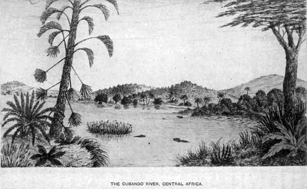
The length from north to south, as far as I have explored, is 970 miles; but, from information obtained from the Kasaka Bushmen on the spot, it may extend much further. The greatest breadth is about 500 miles from east to west, and contains within this area 280,000 square miles.
The northern and eastern portion is within the Zambese basin, except that part drained by the Notuane and its tributaries, which is in the Limpopo basin, all the rest and central part is in the Orange river basin.
The great watershed passes through, taking a diagonal course from the south-east corner to the north-west corner in Ovampoland. The greatest altitude above sea-level being 6100 feet, near the source of the Molapo, the lowest along the shed is 4000 feet, and in Ovampoland 3880 feet.
The river system of South Central Africa has already been described in a chapter to itself, so that the configuration of the country should be more clearly understood; but it is necessary to deal with them again to a certain extent in describing the different localities and native tribes within its boundary.
Lake N’gami is situated nearly in the centre of the desert, to which two of the most important northern rivers, Cubango and Quito, flow, uniting in one, the Tonga, which enters the lake at the north-west corner in 20 degrees 25 minutes South latitude, 24 degrees 45 minutes East longitude, at an altitude of 2813 feet above sea-level. The Cubango or Okavango river, the source of which is much farther north than my explorations extended, passes through a dense and impenetrable bush, extending on both banks far away in 15 degrees South latitude, where there are several tributaries falling in. Following the stream, which is broad and in many places deep, with rapids and waterfalls at different points, passing through forest and open country with native kraals situated on its left banks, occupied by various tribes who are great fishermen and have canoes, and where the hippopotami and crocodile abound, down to where the Quito enters it in 17 degrees 10 minutes South latitude, on to Debabe, a large native station, where the river turns south, branching off into the Chobe and Zambese. The other branch takes its course to Lake N’gami, and receives the Okayanka, which rises in Ovampoland and flows east. All to the north of this river the country varies much in character; the eastern portion is low with extensive swamps covered with bush and fine timber, the western portion rises in ridges with lofty plateaux covered with rich tropical plants and trees, including the giant baobab; there are also extensive plains, with dry watercourses crossing them towards the east; many of them have separate names under the general name Omuramba.
The country to the west of the upper part of the Cubango, which is also called the Okavango, is rich in timber and fine grasses, and game of every description known in South Central Africa; this region is known as Ombango, through which a road passes to the Cubango, and to the north is the land of the Ambuelas, where the tsetse-fly is very common; it is inhabited by the Kasaka and Ombango Bushmen. At the bend of the river, at 16 degrees 20 minutes South latitude, the country rises in ridges towards the north considerably, causing many rapids to be formed in the stream. Below, the country is more level, until my station is reached, where there is a hill on the right of the river, with many wherfs of Bushmen, the altitude being 3370 feet above sea-level, and on the opposite side of the river are many wherfs of the Ovampo, Karakeri, Kororo, Ojego, and others, each with their separate chiefs; the most important is the Ovakuenyami.
The river contains many varieties of fish, which the natives are very expert in catching from their canoes by spearing and setting traps, as also the hippopotami and crocodile.
The large station of the Ovokangari tribe of the Ovampo the chief or king Mpachi rules; and lower down is the Ovalmji tribe, ruled over by Queen Kapongo, and opposite a dry watercourse falls in; another, Omuramba Omapu, which passes through Ovambanquida country, under an Ovampo chief, and where the Kuka Bushmen live on the bank of the Omurambo and Sheshongo, and lower down come the Ovambanquedos tribe, to the west of the chief of the Ovarapo tribe, as also Chikonga, who lives on the banks, and above him the Ovampo chief Tjipangamore. To the east of the Ovokangari or Ovaquangari are various tribes, the Oyomboo and Bavickos at Libebe, who deal largely in ivory, feathers, skins, and slaves with the Portuguese traders. The Ovokangari cultivate the soil, grow corn, are good artificers, manufacture arms, picks, utensils of many kinds for their cooking, and ornaments for their women. They work in iron and copper, and sell many articles to the traders who visit them from the Portuguese settlement on the west coast, and are a superior race to those around them. North of Libebe the Amabomdi, Bakana, Makuka, and the Bavickos tribes reach as far north as the high table-land which divides the Chobe and the Quito rivers; therefore the waters of Cubango, Quito, and their tributaries have their outlet through the Chobe to the Zambese and the large swamp which is connected with the Mababe and Chobe by the Tamienkie and other streams. At the junction of the Quito and Cubango the Oshambio tribe of Ovampos live on a large island under a chief. Down the river is Debabe, and on many islands the Bakuka, Bamalleros, Bakaa, have large kraals, and on the north the Barico Bushmen. The river at Debabe is broad and navigable. Below that kraal at the bend is the cataract Nona and several rapids, and the stream continues down to Lake N’gami under the name of Tonga, receiving in its course several watercourses, under the names of Omaramba, Ovampo, Okayanka, Sheshonga, and others.
This extensive region in many parts along the watercourses is thickly populated, and game abounds, cotton is indigenous, and valuable products of various kinds. A great trade could be carried on if a proper system of communication were opened up through Walfish Bay, Lake N’gami, and down the broad and fine river Chobe to the English traders at all these places, and a great market found for British merchandise. The natives are well-disposed and quite alive to the advantages of trade; they are a well-made, strong people. I was told at Libebe that much further north there were a people of a yellowish-white colour, and also a savage tribe who are nomadic. I believe the former is a remnant of the white race that once occupied the country on the south side of the Lower Zambese who have left so many of their works behind them, and maybe a portion of this white race followed the river up and became mixed with the native tribes. There are also many scattered tribes living amongst these tribes between the Tonga river and Ovampoland, the Mesere, Kaikaibrio, Makololo, Papero, Ohiaongo, Majambi, and others. The Bakalahara Bushmen were once a powerful tribe, who it appears gave the name to this desert. The lion, leopard, panther, and wolves are met with daily. The leopard and panther are more to be feared than the lion when in the thick jungle after game, their form of attack is so cat-like in approaching their prey, taking advantage of every cover until the final spring is made. The many lagoons and swamps seem to be their favourite hunting-ground. In all the waters of these rivers fish abound, of many varieties. Crocodiles, hippopotami, iguanas, otters and snakes are plentiful everywhere along the streams. Unfortunately this region is very unhealthy. The sickly season lasts from September to May; the other months of the year it is very healthy. The malaria from the standing pools in the hot dry season causes fever, which is very difficult to get rid of.
Down the Tonga the natives build their huts in these island homes for safety; they are circular mud-huts with high thatched roofs; they are similar to those on the Upper Cubango, and they hunt the hippopotami. On the lower part of the Quito I shot one in the head, as he was poking his nose out of the water. The skin we use for several purposes, mostly for sjamboks. Large snakes seem to swarm in every part, particularly the python. In a small stream where I thought to be free from crocodiles, I took a daily bath during my stay at my station. On one occasion I was enjoying a swim at the foot of a small fall of beautiful clear water; hearing a great splashing behind me, I turned and saw an enormous snake passing me at great speed, lashing the water into my face, and a few seconds after he was lost in the tall reeds below. Expecting one or two more might follow, I was soon standing on the bank; but before I could dress, down came four others, large, and three small ones, and passed into the reeds below. The largest appeared to be twenty feet in length, and very large round the body; their skin was dark brown with dirty yellow marks. I knew them at once to be the python. A few days after I shot one that measured eighteen feet three inches in length, and three feet round the body, and three feet from the tail a large hook was fixed. I had a similar adventure some time before in Bechuanaland with one which measured sixteen feet two inches, and inside was a steinbok. At night they make a great noise.
Every kind of game is found here. Elephants may be seen in hundreds; four kinds of rhinoceros: the black boreli, with two horns of equal size; another black with one large and one small horn; a white with two; and another white with one long horn, which is the most rare; their native name is Chikooroo. I made a knobkerry out of the horn, which measured two feet eleven inches, from one I shot the previous year. Buffaloes, giraffe, blaawbok, elands, gnu, hartebeest, sassaybe, gemsbok, koodoos, pallah, and others; also wild boar which grow to a great size, wild dogs and a host of smaller animals. The ostrich may be seen on the plains in troops of hundreds; but as guns are now becoming more common with the natives, they will soon be thinned out. There are also many beautiful blue cranes, secretary-birds, mayhens, and legions of ducks, geese, and beautiful small birds; monkeys and baboons everywhere, mostly in the fine trees along the river-banks, and they are much hunted by the leopards and panthers.
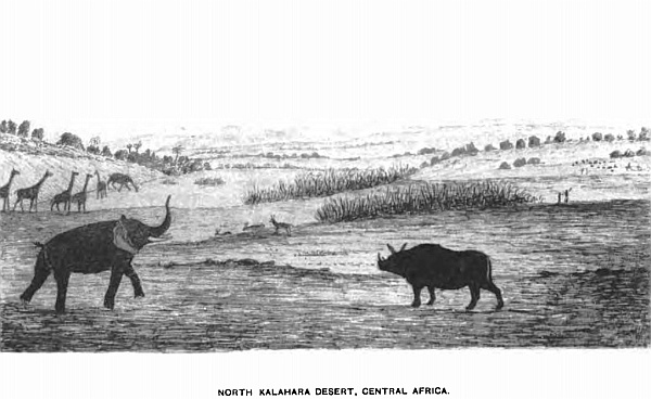
On returning to my camp one evening I had a very narrow escape from one of the former; walking along under the trees on the shore of the Cubango, I saw immediately over my head one of these leopards on the branch of the tree that overhung the river, not twenty feet from me. It was the act of a moment; I up with my rifle and fired at his chest, when down he fell a few paces from me; he seemed to be in the act of springing upon me—another second and I should have been too late. This makes the fourth leopard I have shot in this part. On all occasions I had narrow escapes. In a country like this, where in every turn in the thick bush we meet with one or other of these animals, we have to keep a good look-out and make our rifles our constant companions.
Next week will be Christmas—the height of summer. Thermometer in the shade, under the trees, 107 degrees; but I do not think the heat so oppressive as it is down in the colony, for the simple reason that we have a dense bush, magnificent trees, and long grass that absorbs the heat of the sun’s rays and keeps the earth much cooler by being in shade. In the colony it is open; no trees, scanty grass, and an immense open rocky country, so that the stones become so hot that they destroy the boots. I have frequently made my tea by placing the kettle with water on a stone for half an hour; then put in the tea, let it stand a few minutes, and it is as strong and hot as can be wished.
Most of the natives have been very quiet, but some of the Ovampo have been very troublesome, which has shortened my stay in this part, more particularly amongst the wherfs of the Ovokangari. My Bakuka and Batuana guides were invaluable and took me through without loss. Being the rainy season, water was plentiful, but I had great difficulty in crossing many of the watercourses, impeded by thick belts of jungle, although extensive tracts of country are very beautiful and park-like, lovely clumps of trees were so grouped that art could not improve them. Travelling for days without meeting with any native, on several occasions I was closely beset by lions, which my guide stated were the man-eating lions. Almost daily, thunderstorms came up in the afternoon, many of them terrific in violence; the sunsets also are beyond description for brilliancy of colour. The early morning is generally cloudless; clouds seldom gather before mid-day in summer, but in the winter months they are not visible; this is the healthy season.
There are several roads from Lake N’gami crossing this desert to Damara, Ovampo, and on to Libebe, and the other villages on the Cubango. Every day we went out to hunt up the game to supply the people with food, which I omit to describe as it becomes monotonous.
Very few inhabitants are scattered over this part of the desert, few hills are to be seen, until we arrive at Lake N’gami, when the Lubalo, Makkapola and Makabana hills come into view, and it is round the lake that the people under the chief Molemo live, and at his kraal and others along the river-banks of the Zouga or Bot-let-le. The people are composed of Betuana, Barutsie, Makolo, Bushmen, and several mixed races; each tribe has a petty chief ruling over them, but all subject to the chief Molemo as far as his territory east goes, where the chief Khama joins. The principal villages are Sebubumpie, Mokhokhotlo, Mamakahuie, Mozelenza, Samaai, and numerous others occupied by Bushmen.
The produce of the northern district is collected by the Ovampo traders and brought down to the Walfish Bay, and by Portuguese traders from the Portuguese settlement at Benguela. The trade of Lake N’gami and the Zambese region is carried on by English traders from the Cape Colony, having communication by roads from Ba-Mangwato, the chief Khama’s station, and roads from the lake to Walfish Bay, passing the Ghanze chalk-pits, situated on the watershed, where permanent water is obtained. Many thousand Bushmen live in the more unfrequented parts of the desert, having no settled abode, but remove from water to water as it becomes scarce; there are three separate tribes, the Mesere, Kasaka, and Kaikaibrio, and also some Bakalahara. The greater portion of this part of the Kalahara within the Zambese basin is limestone, covered in places with deep sand, but vegetation is very luxuriant—splendid grasses, and magnificent timber.
It is a good corn-growing country, a variety of valuable herbs come to great perfection, every kind of European plants and fruits thrive; water can be obtained by digging,—a splendid country for immigration.
The Southern and Western Portion of the Kalahara, within the Orange River Basin, the Waters of which fall into the South Atlantic Ocean.
The Orange river is the only outlet to the sea to convey the water brought down by the ancient river system that drains the south, the central, and the western divisions of this extensive and important portion of the Kalahara desert. The Orange for 250 miles forms the southern boundary. The rivers that drain the north-western and the central part of the Kalahara are the twin streams Nosop and Oup, appropriately called twins, as the two join for twenty miles and again separate, both running parallel to each other within a short distance, entering the Molapo close to the great bend, where that river takes the name Hygap, and flows south, and enters the Orange at Kakaman’s drift. The Nosop rises in the Waterberg of Damaraland in two head-waters called the Black and White Nosop, which unite north of Westly Vale and join the Oup at Narukus. The Oup rises in Damaraland in latitude 22 degrees, under the name Elephant river, and gathering the waters of other small branches, joins the Nosop at Narukus for twenty miles, then becomes an independent stream and, as I have stated, falls into the Molapo. Several shallow watercourses traverse the desert, but are not of sufficient importance to merit a description. The other river connected with the above system is the Molapo, which rises on the west slope of the central watershed at an altitude of 5350 feet, in 26 degrees 5 minutes South latitude, 26 degrees 25 minutes East longitude, where a plentiful supply of pure water flows throughout the year, and takes a westerly course to the great bend in latitude 25 degrees 50 minutes East, longitude 21 degrees 16 minutes, when it takes the name Hygap, as already stated, receiving in its course the small streams Moretsane and Setlakoola. The Kuruman river rises in the south of the Kuruman mission station, and with its small tributaries flows west and enters the Hygap below the great bend. The Back river commences in a range of the Brinus mountains, a beautiful and picturesque group, several thousand feet in height, of granite formation, well-wooded in the kloofs and ravines. The peculiar feature of the river is that it has two outlets, one to the east into the Hygap, the other to the west into the Great Fish river. South of this river three mountain streams drain the southern Kalahara, viz. the Nisbet, Aamo, and Keikab, which fall into the Orange to the west of the Hygap. The Great Fish river, which completes the river system of the Kalahara in the Orange river basin, rises in the Awas mountain in Damaraland, 22 degrees 40 minutes South latitude, 17 degrees 30 minutes East longitude, at an altitude of 6400 feet, and flows south for 430 miles, and enters the Orange river ninety miles from its mouth. The country through which it flows is very dry from the scarcity of rain. There are no important streams in the east, but on the west there are many tributaries that drain the high mountain country. The Chun rises in the Mitchell mountains, on the border of Great Namaqualand, receiving the Kurick branch, passing through a beautiful and wild country to the south of Nababis station. The three small tributaries of the Great Fish river to the north of the Chun in 22 degrees 32 minutes South latitude, are the Ganap, near Reheboth station; the Houra and Manabis; south of the Chun are the Huntop, Koros, and the Amhup, all receiving their water from the high lands of Great Namaqualand. The principal stations on these rivers are the Amhup, Bethany, Kachasa, Kawais, Reems, Hudenap, Brakhout, and a few others of recent date.
The inhabitants are of various tribes, called the Namaquas, Veld-Schoeners, Bundelswaarts, Hottentots, Korannas, Kaffirs, Gobabies, and Bushmen; some of the former cultivate the soil, use ploughs, and keep cattle and sheep; they live near the small fountains and along the river-banks, where they procure water by digging and permanent pits. They live under petty captains. There are several mission stations. Copper is found in many parts of the country, and copper-mines are worked in the south near the Orange river. The geological formation is granite, gneiss, trap, and amygdaloid. From the magnitude of this river, it is evident the country at one time must have been well supplied with rain, as it is a deep, broad, and stony stream, showing how rapid must have been the flow of water down it. Fine timber and bush grow in the kloofs and along the banks; many of the hills are very picturesque, and the country produces fine grasses for cattle.
The trade of the country is greatly improving and is supplied by colonial traders from Port Nolloth on the west coast in Little Namaqualand, which is in the Cape Colony; a railway from that port to the copper-mines on the Orange river has been for many years at work. In the Kalahara desert on the east of the Great Fish river, and the southern portion up to the Hygap river and south of the Brinus mountain and Back river, are several stations and kraals. Nisbet or Barth is the most important, where many Griquas are settled, also at Nabos, Luris, Akuris, Blydver-Wagh, Aams, Oribane, Ariam, and others. The Griquas cultivate the ground, and keep large herds of cattle and sheep, and trade largely with the Cape Colony. Hottentots, Korannas, Bushmen, Kaffirs, Namaquas, and small communities of other tribes live on the banks of the Orange and along the streams, with their cattle-posts, which of late years has greatly added to their wealth and enabled the people to trade largely with the colony.
The bold outline of the lofty hills with their thickly wooded slopes and kloofs add greatly to the beauty of the landscape, more particularly along the Orange river, where the rich vegetation, fine timber and bush, forming deep belts on both sides; the rugged and perpendicular rocks of many colours, which form its banks, clothed with lovely creepers hanging down in festoons with their scarlet pods, make the river scenery very beautiful; and to add to its charm the dense bush swarms with the grey monkey, baboons, and every variety of the cat tribe, even to the lion; pheasants, partridges, guinea-fowl, legions of snipes, ducks, geese, moor-hen, plovers, eagles, vultures, and a variety of hawks, some of them of great size, measuring from tip to tip eight feet; also the heron, crane, and stork, and a variety of others, in addition to the smaller tribes of birds with brilliant plumage.
The otter is very plentiful, the banks being covered with their spoor; also the porcupine. There are a great many islands, many of them large and thickly wooded, and about 300 miles up the stream the beautiful and picturesque waterfall, the Aukrabies, which has a fall of over ninety feet, is a grand sight when the flood-waters come down in their annual flow, rising above their ordinary level from twenty-five to thirty feet, bringing down large trees that go rolling and crashing as they are carried along by the rushing water.
I was outspanned on the north bank of this river in 1871, with two waggons and a cart, for the purpose of making a new tent to one of the waggons that had capsized and rolled over into a sluit a few days previously, and had sent the oxen, forty-eight, on to a neighbouring island to graze early in the morning, when the Griqua chief, living at his kraal not far from my camp, came and informed me the river was coming down. The herds were sent over immediately to bring them off, but before they could do so, the river had risen fifteen feet, consequently the oxen had to swim, passing down mid-stream with a small portion of their heads and horns only visible, the two herds swimming behind with blocks of wood under their arms, and they were carried down a mile and a half before they were able to land, and in less than two hours this river had risen thirty feet.
There are many beautiful stones and pebbles in the river-bed, agate, soap-stone, petrified gum and wood, which I have found of white, brown, black, and red. Diamonds also are found occasionally mixed up in the gravel that has been brought down by heavy floods.
On the north of the Back river and Brinus mountains, the country is more open, extensive grass plains and other portions well-wooded. At Liefdotes, Tobas, and Klopper vlei are large kraals, also at Swart and Hoali, on the north of the Brinus. Up along the east side of the Great Fish river to the Oup, the country is very pretty, splendid grasses and timber; the hills are well-wooded, in some places to their summits. Game abounds; ostriches I have seen in troops of 200.
Two hundred miles north of the Orange river and fifty miles west of the Hygap, in 25 degrees 50 minutes South latitude, 20 degrees 42 minutes East longitude, is Hogskin, a large vlei, thirty-three miles in length, and in some parts three miles in width; the greater portion is dry for nine months of the year. The road crosses it to the Griqua settlement at Meer, which is twenty miles to the north, where there are extensive vleis, 2710 feet above sea-level.
Three rivers flow into the Hogskin vlei, viz. the Snake, the Moi, and the Knaas. After heavy rains the vlei is full, and forms a fine sheet of water, which it retains for some months; wild-fowl and game frequent it at that time. These rivers rise in a hilly country; the Knaas is the largest, and retains water in portions of its bed through the year. Quassam, a large Bushman kraal, is situated on its banks; these Bushmen are distinct from the Bushmen of the desert; they were, many years ago, driven from the Cape Colony, by Sir Walter Currie, on account of their stealing the cattle, and robbing travellers. They first took refuge in the many islands in the Orange river, but were driven out and went north, where they settled at Quassam, and where I nearly lost all my waggons, oxen, and everything, being kept there for two days, and the oxen without grass. Coche Africanda was their captain, and I escaped only by threatening that if he or any of his men moved to detain me whilst I inspanned, I would shoot him dead, holding my rifle ready for action. There were nearly 100 well armed with guns; seeing my determination, they remained passive, and I left.
Eight miles below this kraal is a very pretty spot, a valley surrounded by sand-hills, with limestone between and a spring of water, where several roads meet going to Damara and Ovampo, Lake N’gami, Namaqualand, and the colony. The valley is about a mile in length, and half a mile in breadth, studded with very fine kameel-doorn trees. The sand in these rivers contains very fine particles of copper, and also garnet dust. On the south side of Hogskin vlei are two conical hills, which are very prominent objects, visible sixty miles off, and as they stand alone, surrounded by bush and the vleis, they add greatly to the beauty of the landscape. The highest is 415 feet from the base, the other measures 394 feet; they are called base kopts. A few miles south-west of them I procured several specimens of coal, which cropped out in a large sluit, and also from the side of a hill, and twenty miles beyond. Slate and shale form the beds of the rivers Suake and Moi.