I.—THE EARTH’S CRUST (continued 4)
Reading edition
When the action of the water is not disturbed, the needles and other deposits of the calcareous sediment continue to increase with considerable regularity. In some cases each new layer which is added to the concretions may be studied as a kind of time-measurer, indicating the date when the running water abandoned the cave. At length, however, the soft concentric layers disappear, and are replaced by forms of a more or less crystalline character; for in every case where solid particles exist, subject to constant conditions of imbibition by water, crystals are readily produced. Sooner or later, the stalactites, increasing gradually in a downward direction, meet and unite with the needles rising from the surface of the ground, and, forming by their number a kind of barrier, obstruct the narrower passages and close up the defiles separating the cavern into distinct chambers.
One of these Kentucky caves, called the “Mammoth Cave,” is the largest which is at present known. The whole of its extent has not been as yet fully explored, for it may be almost called a subterranean world, having a system of lakes and rivers, and a network of galleries and passages without number, which cross and recross one another, going down to an immense depth. From the chief entrance to the further recesses of the cave, the distance is reckoned to be not less than 9¼ miles, and the whole length of the two hundred alleys that have been traced out in this enormous labyrinth is 217 miles in extent. This “Mammoth Cave” once served as a retreat for savage tribes, for skeletons of men of an unknown race have been found buried in it under layers of stalactite.
The district which is the most remarkable among all the calcareous countries of Europe for its caves, its subterranean streams, and its abysses is unquestionably the region of the Carniolan and Istrian Alps, which extends to the east of the Adriatic, between Laibach and Fiume. The whole surface of the country, as in certain plateaus of the Jura in France, is everywhere pierced with deep boat-shaped cavities, at the bottom of which the water forms a kind of whirlpool, like the water flowing out of the hold of a stranded ship. Many mountains are penetrated in every direction with caverns and passages, just as if the whole rocky mass was nothing more than an accumulation of cells. On one steep cliff-side may be noticed all kinds of perforations at different heights—arched portals and orifices of fantastic shape; on another there are numbers of springs of blue water gushing from the caves, or from the rocks heaped up at the foot of the cliff, and forming rivulets which disappear a little further on in the fissures of the ground, as if through the holes of a sieve. The whole surface of the plateaus, whether bare or covered with forests, is scattered over with wells, or funnel-shaped holes communicating with subterranean reservoirs.
One of the Istrian rivers, the subterranean course of which, although still unknown as regards a great number of points, has given rise to a most continuous course of investigations, is the celebrated Timavus (Timavo), which falls into the sea near Duino, about twelve miles to the north of Trieste. Virgil’s description no longer applies to the mouths of the Timavo; at present they do not reach the number of nine, because the extermination of the woods of the Carso has diminished the mass of the water, or the action of the stream and the alluvium of the delta have modified the form of the shore. But still it is a magnificent spectacle to see the outlet of the three principal torrents of water which rush foaming out of the heart of the rocks, and are navigable from their mouths to their very source. A river of this importance must certainly receive the drainage of a vast basin, and yet all the neighboring valleys seem perfectly devoid of rivulets, and their surface presents little else but the bare rock; in fact, the whole of the rain and snow-water runs away through underground caverns.
The most remarkable network of caverns in this region of the Alps is that which spreads out from the southwest to the northeast across the Adelsberg group of mountains, between Fiume and Laibach. The principal cave is especially curious on account of its size, the variety of its calcareous concretions, and the torrent which runs roaring through it.
North of the town of Adelsberg the traveler passes along the base of a hill with steep and bare sides, bringing into view the sharp edges of its highly pitched calcareous beds. On the right the stream of the Poik winds peaceably in the valley; and then, its course being arrested by a headland, turning suddenly, it flows into the interior of the mountain through a kind of high portal, opening between two parallel beds of rocks. Unless the water in the stream is very low, it is impossible to follow it over the accumulation of rocks upon its bed; but on the right, at a height of a few yards, there is another entry, through which the traveler may descend dry-shod into a vast cavity or chamber, where the Poik again appears issuing from its narrow passage of rocks.
At this point the cave divides; on the north the stream, the depth of which varies, according to the season, from a few inches to 30 or 33 feet, buries itself in a winding avenue, which has been traversed in a boat as far as a point 1,027 yards from the entrance; on the northeast, a higher avenue, discovered only in 1818, pushes its way far into the heart of the mountain, branching out in various directions into narrow passages and wide compartments. This portion of the grotto, which appears to have been the former bed of the Poik, is the most curious part of the Adelsberg labyrinth; it affords wonderful groups of stalactites, especially in the Salle du Calvaire, the vaulted roof of which, having the enormous span of 210 yards, has dropped upon a hillock of débris a perfect forest of stalagmitic columns and white needles. The full length of the principal cave is not less than 2,575 yards; but very probably some other and still longer avenues may yet be discovered.
Although it is impossible to go in a boat along the subterranean portion of the Poik for a greater distance than 1,027 yards, by traversing the surface of the calcareous plateaus we can at all events trace out the subterranean stream by means of the funnel-shaped holes which open above its course. One of these gulfs, the Piuka-Jama, is situated about a mile and a half to the north of the entrance of the Adelsberg caves; the only way to descend into this is by clinging to the branches of the shrubs and sliding down by the assistance of a cord fastened to the top of the rocks. By these means the entrance to a kind of air-hole may be reached, from which the Poik is visible foaming over its bed of rocks, and only a slope of débris is to be descended to reach the edge of the stream. It can only be followed in the downstream direction for about 275 yards; but it can easily be ascended for a distance of 495 yards by passing under a high portal with lofty pillars, and in this way a point can be reached which is less than a mile from the place where the stream disappeared in the cave of Adelsberg.
Further down the stream the Poik is not visible again until it emerges from the mountain, where it is known under the name of the Planina; it rushes out through a circular arch at the base of a perpendicular bluff crowned with fir-trees. It really is the Poik, as is proved by the equal temperature of water and the sudden increase of its liquid mass after a storm has burst at Adelsberg; but the stream always issues from the cave much more considerable in bulk than it is when it enters, owing to the tributaries which pour into it on both sides during its subterranean course of five to six miles. One of these rivulets, which comes down from the plateaus of Kaltenfeld, joins the Poik at a little distance from its outlet. Above the confluence the principal stream can be ascended in a boat to a distance of more than 3,500 yards, which, with the other explored parts of the subterranean river, makes about three miles. Below the point of outlet the stream is partially lost in the fissures of its bed, and then, joining the Unz, goes on and empties itself into the Danubian Save.
About a dozen miles to the southeast of the Adelsberg and Planina caves extends a large plain surrounded on all sides by high calcareous cliffs, at the base of which nestle seven villages. In this hollow, the most elevated portion of which is under cultivation, the remainder being covered with rushes and other marsh-plants, there are to be found more than 400 funnel-shaped holes resembling those in other parts of Carniola. These dolinas, the average depth of which is from 40 to 60 feet, have each their special name, such as the “Grand Crible” (great sieve), the “Crible-à-froment” (corn sieve), the “Tambour” (drum), the “Cuve” (tub), the “Tonneau” (cask), pointing out the form or some remarkable peculiarity of each abyss. During extremely dry seasons there is only one of these cavities which contains any water; but after continuous and heavy rain, the water of a stream which is swallowed up in the rocks a little above the plain rises with a roaring noise in each of these wells. Torrents escaping from all these open “cribles” form in the wide space hemmed in by the cliffs a sea of blue and transparent water. This is the lake of Jessero or Zirknitz, the lacus Lugens of the Romans. The surface of the sheet of water extends over an area of 14,826 acres; at the time of great inundations, this extraordinary temporary lake, thus vomited out by the underground river, is not less than 24,711 acres. The water runs away through a subterranean channel, and, further on, empties itself into the Unz, below the Planina.
Lacustrine basins of this sort, first emitted, and then again absorbed by a subterranean water-course, are rather rare; there are, however, some other remarkable instances of them in Europe. Thus, in the Oriental Hartz, in the midst of a beautiful spot surrounded by fir-trees, the charming lake called Bauerngraben (Peasants’ Ditch), or sometimes Hungersee (Lake of Famine), sometimes makes its appearance; but when this mass of blue water has filled but for a few days its basin of gypsum rock, it is suddenly swallowed up, and flows away by subterranean channels into the stream of the Helme. The celebrated lake of Copaïs, in Bœotia, may likewise be compared to the Zirknitz lake, at least as regards certain portions of its basin.
RIVERS —A. Keith Johnston
Rivers are the result of the natural tendency of water, as of all other bodies, to obey the law of gravitation by moving downward to the lowest position it can reach. The supply of water for the formation of rivers, though apparently derived from various sources, as from rain-clouds, springs, lakes, or from the melting of snow, is really due only to atmospheric precipitation; for springs are merely collections of rain-water; lakes are collections of rain or spring water in natural hollows, and snow is merely rain in a state of congelation. The rills issuing from springs and from surface-drainage unite during their downward course with other streams, forming rivulets; these, after a further course, unite to form rivers, which, receiving fresh accessions in their course from tributaries (subordinate rivers or rivulets) and their feeders (the tributaries of tributaries), sweep onward through ravines, and over precipices, or crawl with almost imperceptible motion across wide, flat plains, till they reach their lowest level in ocean, sea, or lake. The path of a river is called its course; the hollow channel along which it flows, its bed; and the tract of country from which it and its subordinates draw their supplies of water, its basin, or drainage-area. The basin of a river is bounded by an elevated ridge, part of which is generally mountainous, the crest forming the watershed; and the size of the basin, and the altitude of its watershed, determine, cæteris paribus, the volume of the river. The greater or less degree of uniformity in the volume of a river in the course of a year is one of its chief physical features, and depends very much on the mode in which its supply of water is obtained.
In temperate regions, where the mountains do not reach the limit of perpetual snow, the rivers depend for their increase wholly on the rains, which, occurring frequently, and at no fixed periods, and discharging only comparatively small quantities of water at a time, preserve a moderate degree of uniformity in the volume of the rivers—a uniformity which is aided by the circumstance that in these ones only about one-third of the rainfall finds its way directly over the surface to the rivers; the remaining two-thirds sinking into the ground, and finding its way to spring-reservoirs, or gradually oozing through at a lower level in little rills which continue to flow till the saturated soil becomes drained of its surplus moisture, a process which continues for weeks, and helps greatly to maintain the volume of the river till the next rainfall. This process, it is evident, is only possible where the temperature is mild, the climate moist, evaporation small, and the soil sufficiently porous; and under these circumstances great fluctuations can only occur from long-continued and excessive rains or droughts. In the hotter tracts of the temperate zones, where little rain falls in summer, we occasionally find small rivers and mountain torrents becoming completely exhausted; such is often the case in Spain, Italy, Greece, and with the Orange, one of the largest rivers of South Africa.
In tropical and semi-tropical countries, on the other hand, the year is divisible into one dry and one wet season; and in consequence the rivers have also a periodicity of rise and fall, the former taking place first near the source, and, on account of the great length of course of some of the tropical rivers, and the excessive evaporation to which they are subjected (which has necessarily most effect where the current is slow), not making itself felt in the lower part of their course till a considerable time afterward. Thus, the rise of the Nile occurs in Abyssinia in April, and is not observed at Cairo till about mid-summer. The fluctuations of this river were a subject of perpetual wonderment to the ancient civilized world, and were of course attributed to superhuman agency; but modern travel and investigation have not only laid bare the reason of this phenomenon, but discovered other instances of it, before which this one shrinks into insignificance.
The maximum rise of the Nile, which is about 40 feet, floods 2,100 square miles of ground; while that of the Orinoco, in Guiana, which is from 30 to 36 feet, lays 45,000 square miles of savannah under water; the Brahmaputra at flood covers the whole of Upper Assam to a depth of 10 feet, and the mighty Amazon converts a great portion of its 500,000 square miles of selvas into one extensive lake. But the fluctuations in the rise of the flood-waters are surpassed by some of the comparatively small rivers of Australia, one of which, the Hawkesbury, has been known to rise 100 feet above its usual level. This, however, is owing to the river-beds being hemmed in by lofty abrupt cliffs, which resist the free passage of a swollen stream.
The increase from the melting of snow in summer most frequently occurs during the rainy season, so that it is somewhat difficult to determine, with anything like accuracy, the share of each in producing the floods; but in some rivers, as the Ganges and Brahmaputra, the increase from this cause is distinctly observable, as it occurs some time after the rains have commenced, while in the case of the Indus it is the principal source of flood. When the increase from melted snow does not occur during the rainy season, we have the phenomenon of flooding occurring twice a year, as in the case of the Tigris, Euphrates, Mississippi, and others; but in most of these cases the grand flood is that due to the melting of the snow or ice about the source.
The advantages of this periodical flooding in bringing down abundance of rich fertile silt—the Nile bringing down, it is said, no less than 140 millions of tons, and the Irrawadi 110 millions of tons annually—are too well known to need exposition here. Islands are thus frequently formed, especially at a river’s mouth. Permanent and capacious lakes in a river’s course have a modifying effect owing to their acting as reservoirs, as is seen in the St. Lawrence; while the Red River (North) and others in the same tract inundate the districts surrounding their banks for miles. In tropical countries, owing to the powerful action of the sun, all rivers whose source is in the regions of perpetual snow experience a daily augmentation of their volume; while some in Peru and Chili, being fed only by snow-water, are dried up regularly during the night.
The course of a river is necessarily the line of lowest level from its starting-point, and as most rivers have their sources high up a mountain slope the velocity of their current is much greater at the commencement. The courses of rivers seem to be partially regulated by geological conditions of the country, as in the case of the San Francisco of Brazil, which forms with the most perfect accuracy the boundary-line between the granitic and the tertiary and alluvial formations in that country; and many instances are known of rivers changing their course from the action of earthquakes, as well as from the silting up of the old bed. The inclination of a river’s course is also connected with the geological character of the country; in primary and transition formations, the streams are bold and rapid, with deep channels, frequent waterfalls and rapids, and pure waters, while secondary and alluvial districts present slow and powerful currents, sloping banks, winding courses, and tinted waters; the incline of a river is, however, in general very gentle—the average inclination of the Amazon throughout its whole course being estimated at little more than six inches per mile, that of the Lower Nile less than seven inches, and of the Lower Ganges about four inches per mile.
The average slope of the Mississippi throughout its whole length is more than seventeen inches per mile, while the Rhone is, with the exception of some much smaller rivers and torrents, the most rapid river in the world, its fall from Geneva to Lyons being eighty inches per mile, and thirty-two inches from Lyons to its mouth.
The velocity of rivers does not depend wholly on their slope; much is owing to their depth and volume (the latter being fully proved by the fact that the beds of many rivers remain unaltered in size and slope after their streams have received considerable accessions, owing to the greater rapidity with which the water runs off); while bends in the course, jutting peaks of rock or other obstacles, whether at the sides or bottom, and even the friction of the aqueous particles, which, though slight, is productive of perceptible effect, are retarding agencies. In consequence, the water of a river flows with different velocities at different parts of its bed; it moves slower at the bottom than at the surface, and at the sides than the middle. The line of quickest velocity is the line drawn along the centre of the current, and in cases where this line is free from sudden bends or sharp turns, it also represents the deepest part of the channel. The average velocity of a river may be estimated approximately by finding the surface-velocity in the centre of the current by means of a float which swims just below the surface, and taking four-fifths of this quantity as a mean. If the mean velocity in feet per minute be multiplied by the area of the transverse section of the stream in square feet, the product is the amount of water discharged in cubic feet per minute. According to Sir Charles Lyell, a velocity of 40 feet per minute will sweep along coarse sand; one of 60 feet, fine gravel; one of 120 feet, rounded pebbles; one of 180 feet (a little more than two miles per hour), angular stones the size of an egg.
“Rivers are the irrigators of the earth’s surface, adding alike to the beauty of the landscape and the fertility of the soil; they carry off impurities and every sort of waste débris; and when of sufficient volume, they form the most available of all channels of communication with the interior of continents.... They have ever been things of vitality and beauty to the poet, silent monitors to the moralist, and agents of comfort and civilization to all mankind.” By far the greater portion of them find their way to the ocean, either directly or by means of semi-lacustrine seas; but others, as the Volga, Sir-Daria (Jaxartes), Amu-Daria (Oxus), and Kur (Araxes), pour their waters into inland seas; while many in the interior of Asia and Africa—as the Murghab in Turkestan, and the Gir in the south of Morocco—“lose themselves in the sands,” partly, doubtless, owing to the porous nature of their bed, but much more to the excessive evaporation which goes on in those regions.
SWAMPS AND MARSHES —Élisée Reclus
Marshes proper are shallow lakes, the waters of which are either stagnant or actuated by a very feeble current; they are, at least in the temperate zone, filled with rushes, reeds, and sedge, and are often bordered by trees, which love to plunge their roots into the muddy soil. In the tropical zone a large number of marshes are completely hidden by multitudes of plants or forests of trees, between the crowded trunks of which the black and stagnant water can only here and there be seen. Marshes of this kind are inaccessible to travelers, except where some deep channel, winding in the midst of the chaos of verdure, allows boats to attempt a passage between the water-lilies, or under some avenue of great trees with their long garlands of creepers waving in the shade. Whatever may be the climate, it would, however, be impossible to draw any distinction, even the most vague, between lakes and marshes, as the level of these sheets of water oscillates according to the seasons and years, and as the greater number of lakes, principally those of the plains, terminate in shallow bays which are perfect marshes. Some very important lacustral basins, among others Lake Tchad, one of the most considerable in all Africa, are entirely surrounded by swamps and inundated ground, which prohibit access to the lake itself, and prevent its true dimensions from being known.
In like manner, a portion of the course of many rivers traverses low regions in which marshes are formed, either temporary or permanent, the uncertain limits of which change incessantly with the level of the current. The borders of great water-courses, when left in their natural state, are the localities in which these marshy reservoirs principally exist. The most remarkable marshes of this kind are perhaps those crossed by the Paraguay and several of its tributaries; they consist of wet prairies and interminable sheets of water, which stretch away like a sea from one horizon to the other. They have received the names of Lakes Xarayes, Pantanal, etc. Further south, certain tributaries of the Parana, the Maloya, the Batel, and the Sarandi, which cross the State of Corrientes from northeast to southwest, are nothing but wide marshes, the water of which overflows slowly across the grass on the imperceptible slope of the territory. There is, indeed, one of these marshes, the Laguna Bera, which drains simultaneously into the two great rivers of Parana and Uruguay.
In the same way as the low river-shores are frequently converted into marshes, vast extents of the seacoasts when but slightly inclined are also covered over by marshes, which are generally separated from the main sea by tongues of sand gradually thrown up by the waves. In these marshes, most of which once formed a part of the sea and still mark its ancient outline, the water presents the most varied proportions of saline admixture. These half dried-up bays are rarely deep enough to allow of large vessels sailing in them, and their banks are generally overrun by the most luxuriant vegetation. The shore constantly keeps gaining upon them, and thus tends to the increase of the mainland.
The coasts which surround the Caribbean Sea and the Gulf of Mexico, and also the Atlantic shores of North America from the point of Florida to the mouth of the Chesapeake, are bordered by a very large number of marine marshes, forming a continued series over hundreds and thousands of miles in length. In this immense series of coast-marshes all kinds of vegetation seem to flourish, and threaten to get the better of the mud and water, and to convert them into terra firma. To the south, upon the shores of Colombia and Central America, the mangroves and other trees of like species plunge the terminal points of their aerial roots deep into the mud, crossing and recrossing in an arch-like form, and retaining all the débris of plants and animals under the inextricable network of their natural scaffoldings. The shores of the Gulf of Mexico, in Louisiana, Georgia, and Florida, are bordered by cypress swamps, or forests of cypress (Cupressus disticha); these strange trees, the roots of which, entirely buried, throw out above the layer of water which covers the soil multitudes of little cones, the business of which is to absorb the air. For millions of acres nearly all the marshy belt along the seashore is nothing but an immense cypress swamp, with trees bare of leaves, and fluttering in the wind their long hair-like fibres of moss. Here and there the trees and muddy soil give place to bays, lakes, or quaking-meadows, formed by a carpet of grass lying upon a soil of wet mud, or even upon the hidden water. In Brazil these buoyant beds of vegetation are frequently met with, and the significant name of tremendal has been given to them: in Ireland these are called “quaking-bogs.” The least movement of the traveler who ventures upon them makes the soil tremble to some yards’ distance.
To the north of Florida, in the Carolinas and Virginia, the belt of cypress swamps continues; but in consequence of the change of climate and vegetation, the quaking-meadows are gradually converted into peat-mosses. The surface of the marsh is incessantly renewed by a carpet of green vegetation, while below, the dead plants, deprived of air, carbonize slowly in the moisture which surrounds them: these are the beds of peat which form upon the ground just as the layers of coal were formed in previous geological epochs.
On the southern side, the first great peat-bog of a well-defined character is the “Dismal Swamp,” which extends along the frontiers of North Carolina and Virginia. This spongy mass of vegetation rises ten feet above the surrounding land. In the centre, and, so to speak, upon the summit of the marsh, lies Lake Drummond, the clear water of which is colored reddish-brown by the tannin of the plants. A canal, which crosses the Dismal Swamp to connect it with the adjacent streams, is obliged to make its way along the marsh by means of locks. To the north of Virginia peat-bogs proper become more and more numerous; and in Canada, Labrador, etc., they cover vast expanses of country. All the interior of the island of Newfoundland, inside the inclosure formed by the forests on the shore, is nothing but a labyrinth—a great part of which is still unknown—of lakes and peat-bogs; even on the sides of the hills there are marshes on so steep an incline that the water from them would disappear and run off in a stream if it was not stopped by the thick carpet of plants which it saturates. Many a large peat-bog which may be crossed dry-shod contains more water than many lakes filling a hollow of the valley with deep water.
Opposite Newfoundland, on the other side of the Atlantic, Ireland is hardly less remarkable for the enormous development of its peat-mosses or bogs. These tracts of saturated vegetation, in which Sphagnum palustre predominates, comprehend nearly two and a half millions of acres—the seventh part of the whole island. The inhabitants continue to extract from them, every year, immense quantities of fuel. The spaces left by the spade in the vegetable mass are gradually filled up again by new layers. After a certain number of years, which vary according to the abundance of rain, the depth of the bed of water, the force of vegetation, and the slope of the soil, the turf “quarry” is formed anew. In Ireland it generally takes about ten years to entirely fill up again the trenches, measuring from nine to thirteen feet in depth, which are made in the bogs on the plains, when a fresh digging of turf may be commenced. In Holland, crops of this fuel may be gathered, on an average, every thirty years. In other peat-moss districts the period of regeneration last forty, fifty, and even a hundred years. In France, on the borders of the Seugne (Charente-Inférieure), it has been ascertained that ditches five feet deep and nearly seven feet wide are completely obstructed by vegetation after the lapse of twenty years. As for the beds of peat which carpet the sides of mountains, they take centuries to form afresh.
In Ireland, the Low Countries, the north of Germany and Russia, heaps of trunks of former forest-trees—oaks, beech, alder, and other trees—are frequently discovered, which by their decay have made way for the peat-mosses. The Sphagnum, too, often takes possession of ground of which man had previously made himself master, and in many places roads, remains of buildings, and other vestiges of human labor are found below the modern bed of vegetation by which they are now covered. Certain peat-bogs in Denmark and Sweden may be considered, on account of the curiosities which have been found in them, as perfect natural museums, in which the relics of the civilization of ancient nations have been preserved for the savants of our own day.
The air above the peat-mosses of Ireland and other countries in the world is not often unhealthy, either because the heat is not sufficient to develop miasma, or else because the vegetation, by absorbing the water into its spongy mass, impedes the corruption of the liquid, and produces a considerable quantity of oxygen. Further south, the peat-mosses, which are intermixed with pools of stagnant water, and especially marshes properly so-called, generate an impure air, which spreads fever and death over the surrounding country. Unless marshes are surrounded with dense forests, which arrest the dispersion of the gases, the latter exercise a most injurious influence on the general salubrity of the district; for during dry weather, a vast area of the bed of the marshes becomes exposed, and the heaps of organic débris lying on the bottom decompose in the heat and infect the whole atmosphere. The average of life is much shorter in all marshy countries than in the adjacent regions which are invigorated by running water. In Brescia, Poland, in the marshes of Tuscany, and in the Roman plains, the wan and livid complexion of the inhabitants, their hollow eyes, and their feverish skin, announce at first sight the vicinity of some centre of infection. There are some marshes in the torrid zone where the decomposition of organic remains goes on with a much greater rapidity than in temperate climates; no one can venture on the edges of these districts without peril to his life. As Frœbel ascertained in his journey across Central America, the miasma is occasionally produced in such abundance that not only can it be smelt, but a distinct impression of it is left upon the palate.
LOWLAND PLAINS —William Hughes
The plateaus and mountain regions of the globe occupy a large portion of its surface—perhaps more than half of the whole extent of the land—and their influence over its climate and other natural conditions affecting mankind is very great. The highlands of the Old World—fitted by their physical attributes to be the home of pastoral and nomad races—were among the regions earliest occupied by mankind. From the banks of the Euphrates and the primeval cities of the Assyrian plain, the course of the shepherd-warrior—whether directed to the east or the west—led toward some of the elevated regions which stretched thence within the same (or nearly the same) degrees of latitude, and which, at least in a general sense, are under like conditions of climate. The highlands of Persia and Afghanistan, in the one direction, of Syria and the Lesser Asia, in the other, display abundant evidence, both in traditional and monumental records, of their early occupation by man. From the one, the natural order of advance leads to the fertile plains of India; from the other, to the shores of the Mediterranean, whence is easy transit to the peninsula and islands that lie beyond.
But if the highlands of the earth were early the dwelling-place of the shepherd-warrior, it was within the adjoining lowland plains and fertile river basins that the arts of civilization were first called into being, that towns were built, that population became numerous, and that systems of social polity were developed. The lowland plains of Asia and Europe constitute, in the present day, the most populous regions of the globe, and include by far the more numerous portion of the human race. The like regions in the New World are fast filling with inhabitants, as the redundant population of older lands is directed, in an ever-flowing stream, across the waters of the Atlantic.
The most important and extensive among the lowland plains of the Old World are the following:
In Asia.—Plain of the Euphrates and Tigris (the ancient Mesopotamia and Babylonia); Plain of Hindustan, or Northern India; Plain of China, embracing the northeast part of that country; Plain of Siberia; Plain of Turkestan. Among lowland regions of less importance are the plains of Pegu, Siam, and Tonquin, all within the Indo-Chinese peninsula, or India beyond the Ganges.
In Europe.—The Great Eastern Plain, embracing nearly the whole of Russia; Plain of Hungary, embracing the middle portion of the valley of the Danube; Plain of Wallachia and Bulgaria, or the Lower Danube; Plain of Lombardy, or Northern Italy; Plain of Languedoc, in the south of France; Plain of Andalusia, in the south of Spain; Plain of Bohemia, or basin of the Upper Elbe.
The limits and direction of these regions may be traced upon any ordinary map, by means of their coincidence with the great river basins of the Eastern Hemisphere. They include the longer slopes of the land, which are directed toward the north and northwest, as well as the less extensive low grounds which border the Indian and Pacific Oceans. The Siberian plain alone comprehends an area equal to that of Europe, and the rivers by which it is watered are among the most considerable in the Old World. So vast an area, under other conditions of climate, might have become the home of populous nations, the seat of civilization and empire. But its high latitudes, which involve the rigor of an Arctic sky, condemn a large portion of Siberia to the condition of a sterile wilderness, and must prevent even its more favored districts from being other than thinly inhabited. The dreary swamps and morasses of the tundras, which replace, during the brief summer of those latitudes, the plain of ice and snow, stretch along the shores of the Arctic Sea through a vast extent of this widespread region.
Conditions hardly more favorable belong to the extreme northern portion of the great plain of Europe, the slope of which is directed toward the White Sea and the Arctic basin. But a large portion of Eastern Europe is inclined toward a southerly sky, and is watered by rivers which have their outfall into the Black and Caspian Seas. The Volga, the longest of European rivers, belongs to the Caspian basin, the most depressed portion of the entire region.
The southeastern division of the European lowland, and the adjacent portions of Asia, constitute the region of the steppes. These occupy an immense portion of the empire of Russia, and are among the most characteristic of the physical features of the Old World. The steppes are grassy plains—prairies, or meadows, they would be called in the New World—which occupy a vast belt of the European and Asiatic continents. They stretch eastward from the banks of the Dnieper far into the heart of Asia—along the shores of the Caspian and Aral Seas, and as far as the banks of the great river Obi. Indeed, in so far as their grassy covering and general level expanse—among the prime characteristics of the steppe-land—are concerned, a like region may be said to extend to the eastward through Central Asia, as far as the Great Wall of China and the valley of the Amour. This is the “land of grass” of the Mongol shepherd, the true home of the Tartar nations, whose descendants yet preserve in their songs the memory of their famous leader Timour—the Tamerlane of historic record. So vast is the extent of this grass-covered region, that a mounted horseman, it has been said, setting out from one of its extremities at the beginning of the year, and traveling day and night at his utmost speed, would find the season of spring elapse ere he reached its further limits.
The southwestern portion only of the steppe-land falls within the limits of Europe. This exhibits an unbroken expanse of level plain—fatiguing to the eye from its perfect uniformity—dry and burned up by excessive heat in summer, a pathless expanse of snow during the opposite season of the year. The steppe is only productive during the brief time that the thirsty soil is refreshed by the rains of spring and early summer. Its aspect is then, for a time, glowing and verdant; grass and wild flowers cover the earth with a carpet of varied and attractive hues, and the wild cattle and horses luxuriate in the abundant pasture. In the autumn, when the herbage has become dry and withered, the steppe sometimes exhibits a vast sheet of rolling flame, the grass being occasionally fired by accident, at other times intentionally, for the sake of the young crop which springs up through the ashes. The illusive phenomena of mirage—the result of atmospheric refraction, engendered by the intense dryness of the air—are of frequent occurrence in the steppe. Sometimes the eye is cheated by the semblage of a lake, which vanishes on approach. In other instances, the traveler over these wild regions appears to see rising before him, and glittering through the dense mist which often prevails during the hours of midday heat, the towers and other buildings of a distant city. Spires, trees, bridges, rivers, all appear in picturesque combination, only to sink into confusion as they are approached. When the spot where the city of enchantment had seemed to stand is actually reached, there is found only the long, dry grass, waving as elsewhere in the surrounding waste. The vast accumulation of dry sand on the surface gives rise to another phenomenon, of frequent occurrence on the steppe, resembling waterspouts upon the sea, excepting that the column is filled with dust instead of water. “Suppose the great flat steppe stretched out beneath the blue sky—nothing visible—no breath of air apparently stirring—the whole plain an embodiment of sultriness, silence, and calmness—when gradually rise in the distance six or eight columns of dust, like inverted cones, two or three hundred feet high, gliding and gliding along the plain in solemn company; they approach, they pass, and vanish again in the distance, like huge genii on some preternatural errand.”
Such is the region over which the semi-nomad tribes of Tartar shepherds, who constitute a fraction of the vast population of the Russian Empire, pasture their herds. It is only here, within the limits of Europe, that the camel is successfully reared. Odessa, the great outport of southern Russia, stands almost on the edge of the steppe, and the whirlwinds of dust that pass through its streets, and constitute, during a portion of the year, one of its chief drawbacks as a place of residence, furnish obvious evidence of this proximity. The steppe includes two-thirds of the Crimean peninsula, the extreme south of which, however, is traversed by a hill-range of considerable elevation, and exhibits widely different features.
Beyond the Dnieper, the Don, and even the Volga, the same region of alternate grassy plain and sandy waste stretches far into the Asiatic continent. To the east and north of the Caspian and the Aral are the steppes over which roam the hordes of the Khirghiz. The names of Kara-kum and Kizil-kum, given respectively to the sandy wastes which extend upon either side of the river Syr, or Jaxartes, are strikingly indicative of the general character of the tracts to which they are applied.
Mr. T. W. Atkinson, in his Travels in Regions on the Upper and Lower Amour, thus describes the journey through these wild regions: “For many miles the sand was hard, like a floor, over which we pushed on at a rapid pace. After this we found it soft in places, and raised into thousands of little mounds by the wind. Our horses were now changed, and in an hour these mounds were passed, when we were again on a good surface, riding hard.... Hour after hour went by, and our steeds had been changed a second time.... In our route there was no change visible—it was still the same plain; there was not so much as a cloud floating in the air, that, by casting a shadow over the steppe, could give a slight variation to the scene.... The whole horizon was swept with my glass, but neither man, animal, nor bird could be seen.... We rode on for several hours, but there was no change of scene. One spot was so like another that we seemed to make no progress.... No landmark was visible, no rock protruded through the sterile soil; neither thorny shrub nor flowering plant appeared, to indicate the approach to a habitable region; all around was ‘kizil-kum’ (red sand).”
The perfect solitude and unbroken silence of the desert are not less characteristic than its wearisome monotony of surface. No sound of bird or animal breaks the solemn stillness which reigns around; no trees expose their foliage to the influence of the wind. The course of the traveler is still onward, through the same apparently interminable waste. “Fourteen hours had passed, and still a desert was before us. The sun was just sinking below the horizon. The Kirghiz assured me that two hours more would take us to pastures and to water.... It had now become quite dark, and the stars were shining brilliantly in the deep blue vault. My guides altered their course, going more to the south. On inquiring why they made this change, one of them pointed to a star, intimating that by that they must direct their course.
“We traveled onward, sometimes glancing at the planets above, and then anxiously scanning the gloom around, in the hope of discovering the fire of some dwelling that would furnish food and water for our animals. Having ridden on in this manner for many miles, one of our men stopped suddenly, sprang from his horse, and discovered that we had reached vegetation. The horses became more lively and increased their speed, by which the Kirghiz knew that water was not far off. In less than half an hour they plunged with us into a stream, and eagerly began to quench their terrible thirst, after their long and toilsome journey.”
The features above described are those of the steppe region, regarded as a whole. But this aspect undergoes considerable variation in particular localities. The Lower Steppes, as those portions of the great plains which immediately border the Caspian are termed, exhibit a soil largely impregnated with saline particles, and contain numerous salt-water lakes. Some of these lakes furnish a large quantity of salt, derived by means of evaporation. This region resembles in aspect the dried-up bed of a sea. The Caspian, upon which it borders, occupies the lowest part of a depression below the general level of the earth’s surface, its waters being 81 feet lower than those of the Black Sea. The extent of the Caspian appears to be gradually diminishing.
The features of the steppe-land, however, are exceptional to the general characteristics of the European plain, regarded as a whole. Large portions of its middle and western divisions possess a rich arable soil, and exhibit annually a waving sea of corn. The geographical limits of the lowland region are marked, in the direction of north and south, by the Black Sea and the Arctic Ocean. The eastwardly portions of this vast level expanse stretch into the heart of Asia. In the west it reaches the shores of the Baltic, and is thence prolonged, with narrower dimensions, through northern Germany and the low flats of Holland, until it subsides beneath the water of the German Ocean. Throughout this vast extent, tertiary and recent formations prevail, and the abundant clays, sands, and gravels give their character to the surface-soil. The plain lying to the south of the Baltic consists principally of sandy heaths, and contains, toward the seashore, a vast number of small lakes or meers.
The low shores of Holland—conquered from the sea by the persevering industry of the Dutch nation—furnish a conspicuous example of the sand-hills, or dunes, which are often found on low sandy coasts, and which owe their origin to the action of prevailing winds upon the loose drift-sand. Where no means are adopted to fix them to the soil, the sand-hills become agents of destruction, sometimes overwhelming whole villages in their slow but steady advance inland. But this is not the case in Holland, where the ingenuity of the Dutch has converted them from instruments of destruction into a means of national preservation. In some of the provinces of the Netherlands, a large portion of the land is actually lower than the level of high-water mark, and is therefore exposed (it might appear) to the ravages of the adjoining ocean. But from the channel of the Helder southward, the coast is protected by a line of broad dunes, or sand-hills, which are partially covered with grass or heath, and are in some places from forty to fifty feet in height. These have been formed by the natural process above adverted to, and still in operation; the prevalent sea-winds raise banks or ridges of sand at a short distance from the coast, which the inhabitants prevent from proceeding further inland by sowing them with a kind of grass (arundo arenaria), the long roots of which bind the whole mass firmly together.
The district of the Landes, in the southwest corner of France, offers an example of the combined action of sand and sea which is widely different from the above in its results. The coast here exhibits a line of shifting sand, backed toward the interior by a belt of pine-forest. For a length of nearly two hundred miles, from the mouth of the Garonne to that of the Adour, there stretches along the extreme edge of the sea a range of hills composed of white sand, as fine as though it had been sifted for an hour-glass. Every gale changes the shape of these rolling masses of drift-sand. A strong wind from the land flings millions of tons of sand per hour into the sea, to be again washed up by the surf, flung upon the beach, and with the first Biscay gale blown in whirlwinds inland. A water hurricane from the west has been known to fill up with sand many square miles of shallow lake, driving the displaced waters inland, dispersing them among the pine-woods, flooding and frequently destroying the scattered hamlets of the people, and burying forever their fields of millet and rye. The shepherds of the Landes pursue their avocation mounted upon stilts, which raise them above the reach of the sand-blasts. The pine-forests yield annually a large supply of resin, the only harvest of this wild region. Intermixed with the pine-forests, a chain of shallow and marshy lakes stretches in a direction parallel to the coast, and at a few miles inland.
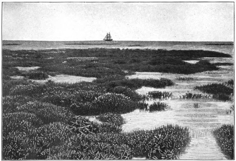
Great Barrier Coral Reef, Queensland, Australia
This Reef is composed entirely of Stag’s Horn Coral (
Madrepora Hebes
)
The lowland plains of the New World are on a scale of vast magnitude, and, if not superior in extent to those of the Eastern Hemisphere, yet bear a much larger proportion to the entire area of the land. They are watered, moreover, by the longest rivers of the globe, and enjoy, for the most part, conditions of situation and climate in the highest degree favorable to man. Both in North and South America, the whole central expanse of the continent exhibits a vast succession of lowland plains, the only division between the different portions of which is that formed by the watersheds of its longer rivers—not always to be traced without difficulty, owing to the generally level nature of the entire plain. In North America, the prairies; in South America, the tracts known as llanos, selvas, and pampas, are included within the lowland region, and exhibit some of the most characteristic among the aspects of nature in the Western world.
The prairies coincide, in a general sense, with the middle and upper portion of the Mississippi Valley, embracing the vast region which extends from the Great Lakes to the base of the Rocky Mountains. They are covered in their natural state with a rich herbage, and exhibit a waving sea of grass several feet high. At intervals, toward the banks of the rivers, patches of forest vegetation break the uniformity of the prospect, but the prairie itself is destitute of trees, and (as the name implies) is merely a grassy plain, or meadow. Alternate forest and prairie constitute the great features of natural scenery in the New World. When the rich soil of the prairie-land is broken up by the plow—an operation which is rapidly progressing, year by year, within the Western States of America—it yields abundant crops of corn. There are, however, within the vast extent of the North American continent, immense regions which yet retain the aspect of the wilderness. It was within these regions that the buffalo roamed, in vast herds, and that the native Indian hunter pursued his game ere the advancing footsteps of the white man had driven him from his haunts.
The llanos, or savannahs, are vast grassy plains, which occupy nearly the whole basin of the Orinoco River, excepting only toward its highest portion, when they are succeeded by wooded plains. The llanos resemble in general features the prairies of the Mississippi Valley, but have for the most part a lower level, and (owing to the abundant rains of the torrid zone) are annually inundated by the rivers to an immense extent. Whole districts, embracing thousands of square miles, are annually converted, within the interior plains of South America, into lakes, or temporary seas of fresh water, to be rapidly evaporated under the burning rays of a vertical sun. At the close of the rainy season the llanos are covered with grass, and form rich natural pasture-grounds. During the prolonged season of drought which ensues, the verdure is entirely destroyed, and the parched earth opens in wide and deep crevices—again to be laid under water with the recommencement of the rains.
The selvas, or forest-plains, belong to the valley of the Amazon, and include an immense area of Brazil, watered by the lower portion of the great stream and its chief tributary, the Madera. Vast regions are here covered by an uninterrupted forest, composed of trees of giant growth, their boughs interlaced by immense creeping plants, and the ground beneath thickly covered with a dense growth of underwood. To the southward of the forest region are vast grassy plains, which stretch in that direction into the valley of the Paraguay.
The pampas, or plains of the Paraguay and Paraná valleys, exhibit the same luxuriant natural growth of herbaceous plants as other lowland regions of the New World. They include an immense region, which stretches from the neighborhood of the southern tropic far to the southward of the river Negro (lat. 39° S.), and from the banks of the Paraná to the eastern base of the Andes. The pampas are variously covered with long coarse grass, mixed with wild oats, clover, and other herbage. The tract of country known by the name of El Gran Chaco, immediately to the westward of the upper Paraguay—scarcely tenanted excepting by wild beasts—exhibits a luxuriant covering of grass, which springs from a soil possessed of the highest natural capabilities.
Further south, the plains that extend from Buenos Ayres to the foot of the Andes are covered, during a great part of the year, with gigantic thistles, which grow to the height of seven or eight feet, and are so thick as to render the country almost impassable. For nine months of the year the thistles are here the predominant (and almost the sole) feature of the vegetable kingdom; but with the heats of summer they are burned up, and their tall leafless stems are leveled to the ground by the powerful blast of the pampero, or southwest wind, which blows from the snowy ranges of the Andes, after which the ground is covered for a brief season with herbage. This is destined, with the returning spring, again to give place to the stronger vegetation which it had succeeded, and for a time supplanted.
THE SMELL OF EARTH —G. Clarke Nuttall
A bright fine evening after a day of rain is one of Nature’s compensations. The air is peculiarly sweet and fresh, as though the rain had washed all evil out of it. The mind, relieved from the depressing influence of continuous rain, is exhilarated, and, above all, the strong smell of the earth rises up with a scent more pleasing than many a fragrant essence. In the town, indeed, this earthy smell is often obscured by the bricks and mortar which cover the land, and by the stronger, less wholesome, odors of human life, but in the country it has full sway, and fills the whole air with its presence. Even a slight shower, particularly after drought, is sufficient to bring out the sweet familiar smell of the land and thrust it upon our notice.
The smell of freshly turned earth is often regarded by country lovers as one of the panaceas for the ills of the flesh, and “follow a plowshare and you will find health at its tail” has proved a sound piece of advice to many a weakly town-sick one, over whose head the threatenings of consumption hung like the sword of Damocles, though it is possible that it is the fresh air, and more especially the sunshine, which are the saving media, and not the mere smell.
But what do we know about this characteristic smell of the soil? Can we regard it as the mere attribute of the soil as a simple substance, such an attribute as is, for instance, the peculiar smell of leather, or the odor of india-rubber; or can we go deeper and find that it is really an expression of complexity below?
Strangely enough this is the case, for the smell of damp earth is one of the latest sign-posts we have found which lead us into a world which, until recently, was altogether beyond our ken. It points us to the presence, in the ground beneath us, of large numbers of tiniest organisms, and not merely to their presence only, but to their activity and life, and reveals quite a new phase of this activity. A handful of loose earth picked up in a field by the hedgerow, or from a garden, no longer represents to us a mere conglomeration of particles of inorganic mineral matter, “simply that and nothing more”; we realize now that it is the home of myriads of the smallest possible members of the great kingdom of plants, who are, in particular, members of the fungus family in that kingdom, plants so excessively minute that their very existence was undreamed of until a few years ago.
Some faint idea of their relative size, and of the numbers in which they inhabit the earth, may be gleaned from the calculations of an Italian, Signor A. Magiora, who, a short time ago, made a study of the question. He took samples of earth from different places round about Turin and examined them carefully. In ordinary cultivated agricultural soil he found there would be eleven millions of these germs in the small quantity of a gramme, a quantity whose smallness will be appreciated when it is remembered that a thousand grammes only make up about two and a quarter pounds of our English measure. Thus, a shovelful of earth would be the home of a thousand times eleven millions of bacteria—but the finite mind can not grasp numbers of such magnitude. In soil taken from the street, and, therefore, presumably more infected with germs, he calculated that there was the incredible number of seventy-eight million bacteria to the gramme. Sandy soil is comparatively free from them, only about one thousand being discovered in the same amount taken from sandy dunes outside Turin.
But though the workers were hidden yet their works were known, for what they do is out of all proportion to what they are; in fact they perform the deeds of giants, not those of veriest dwarfs. “By their works shall ye know them” might be a fitting aphorism to describe the bacteria of the soil. And the nature of their deeds is widely various, for though the different groups are members of one great family, yet, like the individuals of a human family that is well organized, they have each of them their special vocation. In the spring time, when the sun warms the chilly earth, they act upon the husks that have protected the seeds against the rigors of the winter, and crumble them up so that the seedling is free to grow; they break down the stony wall of the cherry and plum which has hitherto imprisoned the embryo; and then, when the young plant starts, they attach themselves to its roots, assist it to take in all sorts of nutriment from air and soil, and thus help it in its fight through life, and when its course has run they decently bury it. They turn the green leaves and the woody stem and the dark root back into the very elements from which they were built up; they effect its decay and putrefaction, and resolve it into earth again. “Dust to dust, ashes to ashes,” is the great life work of the earth bacteria.
But up to about 1898 the fresh smell of the earth, the smell peculiar to it, had not been in any way associated with these energetic organisms, and it was quite a new revelation to find that it was a direct outcome of their activity. Among the many bacteria which inhabit the soil, a new one, hitherto unknown, has been isolated and watched. It lives, as is usual with them, massed into colonies, which have a chalky-white appearance, and as it develops and increases in numbers it manifests itself by the familiar smell of damp earth, hence the name that has been given it—Cladothrix odorifera. Taken singly, it is a colorless thread-like body, which increases numerically by continuous subdivisions into two in the direction of its length. It derives its nutriment from substances in the soil, which either are, or have been, touched by the subtle influence of life, and in the processes of growth and development it evolves from these materials a compound whose volatilizing gives the odor in question. This compound has not yet been fully examined; it is not named, nor have all its properties been satisfactorily elucidated, but two facts concerning it stand out clearly. One is that it is the true origin of the smell that we have hitherto attributed to earth simply; and the other, that it changes into vapor under the same conditions as water does. Therefore, when the sun, shining after the rain, draws up the water from the earth in vapor form, it draws up, too, the odorous atoms of this newly found compound, and these atoms, floating in the air, strike on our olfactory nerves, and it is then we exclaim so often, “How fresh the earth smells after the rain!”
Though moisture, to a certain extent, is a necessary condition of the active work of these bacteria, yet the chief reason why the earthy smell should be specially noticeable after the rain is probably because this compound has been accumulating in the soil during the wet period. We only smell substances when they are in vapor form, and since the compound under consideration has precisely the same properties in this respect as water, it will only assume gaseous form when the rain ceases. The bacteria have, however, been hard at work all the time, and when the sun shines and “drying” begins, then the accumulated stores commence their transformation into vapor, and the strong smell strikes upon our senses. For the same reason we notice a similar sort of smell, though in a lesser degree, from freshly turned earth. This is more moist than the earth at the surface, and hence, on exposing it, evaporation immediately begins which quickly makes itself known to us through our olfactory nerves.
It may also have been remarked that this particular odor is always stronger after a warm day than after a cold one, and is much more noticeable in summer than in winter. This is because moderate warmth is highly conducive to the greater increase of these organisms, and, in fact, in the summer they are present in far larger numbers and exhibit greater vitality than in the winter, when they are often more or less quiescent.
Two other characteristics of Cladothrix odorifera are worthy of notice as showing the tenacity with which it clings to life. It is capable of withstanding extremely long periods of drought without injury; its development may be completely arrested (for water in some degree is a necessity with all living things, from highest to lowest), but its vitality remains latent, and with the advent of water comes back renewed activity. But besides drought it is pretty well proof against poisons. It can even withstand a fairly large dose of that most harmful poison to the vegetable world, corrosive sublimate. Hence any noxious matter introduced into the soil would harm it little ultimately; the utmost it could do would be to retard it for a time.
This, then, is the history of the smell of earth as scientists have declared it unto us, and its recital serves to further point the moral that the most obvious, the most commonplace things of everyday life—things that we have always taken simply for granted without question or interest—may yet have a story hidden beneath them. Like sign-posts in a foreign land, they may be speaking, though in a language not always comprehended by us, of most fascinating regions—regions we may altogether miss to our great loss if we neglect ignorantly the directions instead of learning to comprehend them.
DESERTS —Élisée Reclus
The most important group of deserts in the world is that of the Sahara, which extends across the African continent from the shores of the Atlantic to the valley of the Nile. This immense area is more than 3,100 miles from east to west, and is, on an average, more than 600 miles in breadth; it is, in fact, equal in size to two-thirds of Europe. In this region there is only one season, viz., summer, burning and merciless. It is but rarely that rain comes to refresh these regions, on which the solar rays dart vertically down.
The mean altitude of the Sahara is estimated at 2,000 feet; but the level of the soil varies singularly in the different districts. To the south of Algeria, the surface of the Chott Mel-R’ir, the remains of an ancient sea, which communicated with the Mediterranean, is at the present time more than 165 feet below the Gulf of Cabes; while to the south and east, the ground rises into plateaus and mountains of sandstone or granite to a height varying from 3,300 to 6,660 feet. In the centre of the Sahara stands the Djebel-Hogger, the sides of which are covered with snow during three months in the year; from December to March, its picturesque defiles are traversed by streams which flow some distance and lose themselves beneath the surrounding plains. This group of lofty mountains is the great landmark which forms the boundary between the eastern deserts, or the Sahara proper, and the group of western deserts, designated under the general name of Sahel.
The Sahel is very sandy. Throughout the greater part of its extent the soil is composed of gravel and large-grained sand, which does not give way even under the foot of the camel. Some of the ranges of sand-hills which rise in this desert are chains of small hills, composed of heavy sand which resists the influence of the wind. But in many districts of the Sahel, the arenaceous particles of the soil are fine and small. The trade-winds which pass over the desert distribute these sandy masses into long waves similar to those of the ocean, and here and there raise them into movable sand-hills, which overwhelm all the oases which lie across their path. Traveling toward the southwest, in which direction they are driven by the wind, the sands reach the northern shores of the Niger and Senegal at many points of their course, and by their incessant deposits gradually drive the waters of these rivers toward the south. To the west, the sand of the desert encroaches also upon the ocean. Off the coast which stretches between Cape Bojador and Cape Blanco—pointed out from afar by the highest dunes in the world—a line of sand-banks extends far out into the sea. A current of sand is, therefore, constantly passing across the desert from northeast to southwest. The débris of rocks in a state of decomposition, and the particles brought to the coast of the Gulf of Cabes by the tide, which is very powerful at this point, are driven before the wind into the plains of the Sahel, and thence, after a journey lasting hundreds and perhaps thousands of years, they at last reach the seashore of the Atlantic, in order to recommence in the oceanic currents another eventful odyssey.
Some parts of the eastern Sahara are equally sandy; but the principal parts of the surface of this desert are occupied by plateaus of rock or clay, and by groups of grayish or yellowish mountains. The chains of sand-hills are numerous, and, like those of the west, they travel incessantly under the impulse of the wind in a south or southwest direction. The rocky plateaus are crossed and recrossed here and there by wide and deep clefts, which are gradually filled by the drifted sand, and into which the traveler runs the risk of sinking, like the mountaineer into the crevasses of a glacier. In the hollows, patches of salt take the place of the lakes which in more rainy countries would be found there.
Those districts of the Sahara which are destitute of oases present a truly formidable aspect, and are fearful places to travel over. The path which the feet of the camels have marked out in the immense solitude points in a straight line toward the spot which the caravan wishes to reach. Sometimes these faint footmarks are again covered with sand, and the travelers are obliged to consult the compass, or examine the horizon; a distant sand-hill, a bush, a heap of camels’ bones, or some other indications which the practiced eye of the Touareg alone can understand, are the means by which the road is recognized.
Terrible stories are told by the side of the watch-fires of caravans being overtaken when amid the sand-hills by a sudden storm of wind, and completely buried under the moving masses; they also tell of whole companies losing their way in the deserts of sand or rocks, and dying of madness after having undergone all the direst tortures of heat and thirst. Happily such adventures are rare, even if the accounts of them are at all authentic. Caravans, when led by an experienced guide and protected by treaties and tribute against the attacks of plundering Arabs and Berbers, nearly always arrive at the end of their journey without having undergone any other sufferings than those caused by the intolerable heat, the want of good water, and the coldness of the nights; for the nights which follow the burning days in the Sahara are in general very cold. In fact, the air of these countries being entirely destitute of aqueous vapor, the heat collected during the day on the surface of the desert is, owing to the nocturnal radiation, again lost in space. The sensation of cold produced by this waste of heat is most acute, and especially so to the chilly Arab. Not a year passes without ice forming on the ground, and white frosts are frequent.
In all those countries in the Sahara where the water gushes out in springs or descends in streams from some group of mountains, there is an oasis formed—a little green island, the beauty of which contrasts most strikingly with the barrenness of the surrounding sands. These oases, compared by Strabo to the spots dotted over the skin of the panther, are very numerous, and perhaps comprehend altogether an area equal in extent to one-third of the whole Sahara. In the greater part of this region, the oases, far from being scattered about irregularly, are, on the contrary, arranged in long lines in the middle of the desert. The cause of this is either the higher proportion of moisture contained in the aerial currents which pass in this direction, or, and perhaps principally, the subterranean water which follows this slope, and here and there rises to the surface.
The oases are, par excellence, the country of date-trees; in the neighborhood of Mourzouk there are no less than thirty-seven varieties. These trees form the riches of the tribe, for their fruit supplies food to man as well as to beast—to dromedaries, horses, and dogs. Below the wide fan of leaves, which quiver in the blue air, are thickly growing clumps of apricot, peach, pomegranate, and orange trees, their branches loaded with fruit, and vines intertwining round the trunks; maize, wheat, and barley ripen under the shade of this forest of fruit-trees, and, lower still, the modest trefoil fills up the very smallest intervals of the soil which is capable of irrigation.
To the east of Egypt, which may be considered as a long oasis situated on the banks of the Nile, the desert begins again, and borders the whole extent of the Red Sea. A large part of Arabia presents nothing but sands and rocks, and toward the southeast, in the Dahna, there are solitudes which no traveler, either Arab or Frank, seems yet to have crossed. To the north and east stretch the Nefouds, or “daughters of the great desert,” which are much smaller than the Dahna, but are nevertheless formidable tracts to travel over. One of these regions, which was crossed by Palgrave, is that in which the mass of sand, formerly deposited there by the marine currents, affords the greatest depth; in certain places it is 330, 400, and even 500 feet deep. It can be measured by the eye by descending to the bottom of the funnel-shaped cavities, which the springs of water, spouting out of the adjacent granite or calcareous rock, have gradually hollowed out in the bed of sand. This enormous bed of material, which represents chains of pulverized mountains, does not exhibit an even surface, as one would expect, but, throughout its whole expanse, presents long symmetrical undulations, similar to those waves which roll in the Caribbean Sea under the even influence of the trade-winds. These waves stretch from north to south, parallel to the meridian; it is probable that they are owing to the movement of the earth round its axis. The solid rocks beneath unresistingly obey the impelling force which carries them toward the east, but the movable sands which are above them do not allow themselves to be carried away with an equal rapidity; each day an infinitesimal quantity remains behind and seems to glide toward the west, like the waves of the ocean, the atmospheric currents, and everything that is movable on the face of the globe. The parallel furrows of sand in the Nefouds certainly rise to a greater height than those of the other deserts, and differ much in their aspect from the smaller waves of sand formed by the wind; but the reason is, that the bed of sand in this region is of a very great bulk, and because at this point the swiftness of the globe nearly attains its maximum on account of its vicinity to the equator.
To the east of the Arabian peninsula, the chain of deserts is prolonged obliquely across Asia. The principal part of the plateau of Iran, occupying a quadrilateral space, surrounded by mountains which stop the rains in their passage, consists of sterile solitudes, some covered with saline beds, the remains of dried-up lakes, others spread over with shifting sands, which the wind blows up into eddies, or dotted over with reddish-colored hills, which the mirage renders either nearer or more distant to the eye than they really are, incessantly modifying them according to the undulations of the atmosphere. This plateau is only separated from the steppes of Turkestan by the Elburz Mountains, and is continued toward the east by the deserts of Afghanistan and Beloochistan, which are not so large, and much easier to travel over. Even the rich peninsula of India is protected by a belt of sterile tracts situated on the right and left of the Indus. Between each of the five rivers (Punjaub), which, by the union of their waters, form the great river, stretches a line of steppes in which the torrent-waters of the mountains are soon lost. The soil of these steppes is nearly everywhere barren, except on the edge of the irrigation canals constructed by the inhabitants at a very heavy outlay.
Beyond the mighty central group, whence radiate far and wide the mountain-chains of Asia, the steppes and deserts, mutually alternating according to the topographical conditions, and the abundance or scarcity of water, extend over a space of more than 1,850 miles between Siberia and China Proper. The eastern part of this belt is called, according to the languages, Gobi or Chamo, that is to say, the desert par excellence, and, from its enormous dimensions, corresponds with the Sahara of Africa, situated exactly at the opposite extremity of the long chain of solitudes which stretches right across the Old World. The mirage, the moving sand-hills blown up into eddies, and many other phenomena described by African travelers, are found in certain districts of the Gobi, just the same as in all other deserts. But the cold here is exceptionally intense, on account of the great height of the plateaus, which is on an average 4,950 feet, and the vicinity of the plains of Siberia, which are crossed by the polar wind. It freezes nearly every night, and often during the day. The dryness of the atmosphere is extreme; there is hardly any vegetation, and a few grassy hollows are the only oases of these regions. From Kiahkta to Pekin, there are only five trees for a distance of 400 to 500 miles, which is the width of the desert in this part of Mongolia. The Gobi, however, like the Sahara, was formerly covered by the waters of the ocean; even on the elevated plateaus, old cliffs may be noticed, the bases of which are worn away by the waves, and long strands of round shingle stretch around the area which was formerly occupied by a now vanished gulf.
In North, as in South America, the deserts proper lie to the west of the continent, and occupy the basins commanded by the parallel or divergent walls of the Rocky Mountains.
The most northerly of these American deserts occupies, to the west of Lake Utah, a part of the space called the “Great Basin,” and is comprised between the principal chain of the Rocky Mountains and the Sierra Nevada of California. The desert of Utah is an immense surface of clay, dotted over with thin tufts of artemisia; in certain places, however, it exhibits no trace of vegetation, and resembles a causeway of concrete, intersected by innumerable clefts, forming nearly regular polygons. In the midst of these solitudes no rivulet flows, and no water-spring gushes forth; only after journeying for many a long hour the traveler sometimes comes upon some field of crystallized salt, a white expanse, on which the clouds and blue sky are reflected as on the surface of a lake. On the extreme horizon some volcanic rocks may be seen, like great scoriæ, half veiled by warm atmospheric columns, quivering like the air over the flame of a hot brazier. Across these vast plains, inhabited only by a prodigious quantity of extraordinarily shaped lizards, the road employed by the emigrants used to pass, which was so soon destined to be supplanted by the Pacific Railway from New York to San Francisco.
The deserts of North America, crossed here and there by fertile valleys, extend eastward toward the basins of the Red River and the Arkansas, where they blend with the savannas, and to the south into the Mexican states of Chihuahua, Sonora, and Sinaloa. But in the tropical zone, which commences beyond these points, the heavy summer rains and the much smaller extent of the Mexican territory between the two oceans, have prevented the formation of deserts. Regions destitute of trees and verdure are only again found on the coasts of Peru, to the south of the Gulf of Guayaquil. The trade-winds, after having discharged their moisture on the eastern slopes of the Andes, pass away through the air far above the seashore on the western side of the mountains, and then sweep far out to sea over the surface of the Pacific.
The solitudes of the Andes most resembling the desert regions of the Old World and of the United States are the elongated plateaus which rise one above another between the sea and the principal chain of the Andes, in southern Peru and on the frontiers of Bolivia and Chili; such as the pampas of Islay and Tamarugal and the desert of Atacama. The pampa of Tamarugal, so called from the Tamarugos, or tamarisks, which grow in the hollows where some moisture oozes out of the soil, has a mean altitude of from 2,900 to 3,900 feet. It is a plain nearly covered with beds of salt, or salares, which are worked like rock quarries. The strata of salt are so thick, and rain is so rare upon the plateau, that the houses of the village of Noria, which are inhabited by the workmen, are entirely constructed of blocks of salt. Some deserts, situated to the east of the Tamarugal, on more elevated plateaus, contain a still larger quantity of salt. The pampa of Sal, which is overlooked by the volcano of Isluga, has a mean altitude of not less than 13,800 feet, and its whole extent, which is 125 miles long and from nine to twenty-four miles wide, is perfectly white. The depth of salt deposited upon this plateau varies from five to sixteen inches, according to the undulations of the ground.
Whence do these enormous masses of salt proceed? Doubtless from the sea or ancient lakes which formerly covered these countries and have been gradually emptied by the rising of the soil. Saline matter saturates even the rocks and clays, for a film of salt again forms by efflorescence on all the ground in the desert from which crops have previously been taken. The district of Santa-Rosa, which was completely cleared of salt in 1827, was all white again and fit for working after a lapse of twenty-three years. Sea-salt is not the only production of these immense natural laboratories; but nitrates, sulphates, carbonate of soda, borates of soda and lime, are also found there and increase every year in thickness, thanks to the ephemeral torrents which sometimes descend loaded with débris from the adjacent Cordilleras. Saltpetre is also procured from the pampa of Tamarugal, and is the article which, during all the wars of Europe and America, gave such great commercial importance to the town of Iquique.
The desert of Atacama, the largest of all those in South America, occupies a wide belt of plateaus between the shores of the Pacific and the high rampart of the Andes, which separates Bolivia from the Argentine Republic. This expanse of reddish-colored rocks, and crescent-shaped shifting sand-hills, is so repulsively desolate a place that the conquerors of Chili, whether Incas or Spaniards, never made up their minds to venture into it, in going along the sea-coast; they have been obliged to pass far into the interior, by the plateaus of Bolivia, and to twice cross the Andes before entering the Chilian valleys. Not long since, men of science were the only travelers who dared to enter the desert of Atacama. Nevertheless this formidable-looking country also possesses, like the pampa of Tamarugal, great natural riches, which will not fail to summon the labor of man and all the progress of civilization to these desolate regions. Besides salt and saltpetre, this desert produces guano—that is, heaps of the almost exhaustless droppings of all the sea-birds which settle down in clouds upon the seashore. During the course of centuries the ordure has accumulated into perfect rocks which the sun dries up, and the surface of which is but rarely softened by rain. These masses of detritus, which are, to all appearance, useless upon these barren shores, are life itself to the countries of England, France, and Belgium, which have become exhausted by the extent of cultivation; and, consequently, this substance constitutes a most important element of national commerce.