I.—THE EARTH’S CRUST (continued 2)
Reading edition
To what cause are we to attribute these sudden and apparently temporary invasions of the earth’s surface by rapid currents of water? In all probability to the upheaval of some vast extent of dry land, to the formation of some mountain or mountain range in the neighborhood of the sea, or even in the bed of the sea itself. The land, suddenly elevated by an upward movement of the terrestrial crust, or by the formation of ridges and furrows at the surface, has, by its reaction, violently agitated the waters, that is to say, the more mobile portion of the globe. By this new impulse the waters have been thrown with great violence over the earth, inundating the plains and valleys, and for the moment covering the soil with their furious waves, mingled with the earth, sand, and mud, of which the devastated districts have been denuded by their abrupt invasion.
There have been, doubtless, during the epochs anterior to the Quaternary period many deluges such as we are considering. Mountains and chains of mountains were formed by upheaval of the crust into ridges, where it was too elastic or too thick to be fractured. Each of these subterranean commotions would be provocative of momentary irruptions of the waves.
But the visible testimony to this phenomenon—the living proofs of this denudation, of this tearing away of the soil—is found nowhere so strikingly as in the beds superimposed, far and near, upon the Tertiary formations, and which bear the geological name of diluvium. This term was long employed to designate what is now better known as the “bowlder” formation, a glacial deposit which is abundant in Europe north of the 50th, and in America north of the 40th, parallel, and reappearing again in the Southern Hemisphere; but altogether absent in tropical regions. It consists of sand and clay, sometimes stratified, mixed with rounded and angular fragments of rock, generally derived from the same district; and their origin has generally been ascribed to a series of diluvial waves raised by hurricanes, earthquakes, or the sudden upheaval of land from the bed of the sea, which had swept over continents, carrying with them vast masses of mud and heavy stones, and forcing these stones over rocky surfaces so as to polish and impress them with furrows and striæ. Other circumstances occurred, however, to establish a connection between this formation and the glacial drift. The size and number of the erratic blocks increase as we travel toward the Arctic regions; some intimate association exists, therefore, between this formation and the accumulations of ice and snow which characterize the approaching glacial period.
There is very distinct evidence of two successive deluges in our hemisphere during the Quaternary epoch. The two may be distinguished as the European Deluge and the Asiatic. The two European deluges occurred prior to the appearance of man; the Asiatic deluge happened after that event; and the human race, then in the early days of its existence, certainly suffered from this cataclysm.
The first occurred in the north of Europe, where it was produced by the upheaval of the mountains of Norway. Commencing in Scandinavia, the wave spread and carried its ravages into those regions which now constitute Sweden, Norway, European Russia, and the north of Germany, sweeping before it all the loose soil on the surface, and covering the whole of Scandinavia—all the plains and valleys of Northern Europe—with a mantle of transported soil. As the regions in the midst of which this great mountainous upheaval occurred—as the seas surrounding these vast spaces were partly frozen and covered with ice, from their elevation and neighborhood to the pole—the wave which swept these countries carried along with it enormous masses of ice.
The physical proof of this deluge of the north of Europe exists in the accumulation of unstratified deposits which covers all the plains and low grounds of Northern Europe. On and in this deposit are found numerous blocks which have received the characteristic and significant name of erratic blocks, and which are frequently of considerable size. These become more characteristic as we ascend to higher latitudes, as in Norway, Sweden, and Denmark, the southern borders of the Baltic, and in the British Islands generally, in all of which countries deposits of marine fossil shells occur, which prove the submergence of large areas of Scandinavia, of the British Isles, and other regions during parts of the glacial period. Some of these rocks, characterized as erratic, are of very considerable volume; such, for instance, is the granite block which forms the pedestal of the statue of Peter the Great at St. Petersburg. This block was found in the interior of Russia, where the whole formation is Permian, and its presence there can only be explained by supposing it to have been transported by some vast iceberg, carried by a diluvial current. This hypothesis alone enables us to account for another block of granite, weighing about 340 tons, which was found on the sandy plains in the north of Prussia, an immense model of which was made for the Berlin Museum. The last of these erratic blocks deposited in Germany covers the grave of King Gustavus Adolphus, of Sweden, killed at the battle of Lutzen, in 1632. He was interred beneath the rock. Another similar block has been raised in Germany into a monument to the geologist Leopold von Buch.
These erratic blocks, which are met with in the plains of Russia, Poland, and Prussia, and in the eastern parts of England, are composed of rocks entirely foreign to the region where they are found. They belong to the primary rocks of Norway; they have been transported to their present sites, protected by a covering of ice, by the waters of the northern deluge.
The second European deluge is supposed to have been the result of the formation and upheaval of the Alps. It has filled with débris and transported material the valleys of France, Germany, and Italy over a circumference which has the Alps for its centre. The proofs of a great convulsion at a comparatively recent geological date are numerous. The Alps may be from eighty to one hundred miles across, and the probabilities are that their existence is due, as Sir Charles Lyell supposes, to a succession of unequal movements of upheaval and subsidence; that the Alpine region had been exposed for countless ages to the action of rain and rivers, and that the larger valleys were of pre-glacial times, is highly probable. In the eastern part of the chain some of the Primary fossiliferous rocks, as well as Oolitic and Cretaceous rocks, and even Tertiary deposits, are observable; but in the central Alps these disappear, and more recent rocks, in some places even Eocene strata, graduate into metamorphic rocks, in which Oolitic, Cretaceous, and Eocene strata have been altered into granular marble, gneiss, and other metamorphic schists; showing that eruptions continued after the deposit of the Middle Eocene formations. Again, in the Swiss and Savoy Alps, Oolitic and Cretaceous formations have been elevated to the height of 12,000 feet, and Eocene strata 10,000 feet above the level of the sea; while in the Rothal, in the Bernese Alps, occurs a mass of gneiss 1,000 feet thick between two strata containing Oolitic fossils.
Besides these proofs of recent upheaval, we can trace effects of two different kinds, resulting from the powerful action of masses of water violently displaced by this gigantic upheaval. At first broad tracks have been hollowed out by the diluvial waves, which have, at these points, formed deep valleys. Afterward these valleys have been filled up by materials derived from the mountain and transported into the valley, these materials consisting of rounded pebbles, argillaceous and sandy mud, generally calcareous and ferriferous. This double effect is exhibited, with more or less distinctness, in all the great valleys of the centre and south of France. The valley of the Garonne is, in respect to these phenomena, classic ground, as it were.
The small valleys, tributary to the principal valley, would appear to have been excavated secondarily, partly out of diluvial deposits, and their alluvium, essentially earthy, has been formed at the expense of the Tertiary formation, and even of the diluvium itself. Among other celebrated sites, the diluvial formation is largely developed in Sicily. The ancient temple of the Parthenon at Athens is built on an eminence formed of diluvial earth.
In the valley of the Rhine, in Alsace, and in many isolated parts of Europe, a particular sort of diluvium forms thick beds; it consists of a yellowish-gray mud, composed of argillaceous matter mixed with carbonate of lime, quartzose and micaceous sand, and oxide of iron. This mud, termed by geologists loess, attains in some places considerable thickness. It is recognizable in the neighborhood of Paris. It rises a little both on the right and left, above the base of the mountains of the Black Forest and of the Vosges; and forms thick beds on the banks of the Rhine.
The fossils contained in diluvial deposits consist, generally, of terrestrial, lacustrine, or fluviatile shells, for the most part belonging to species still living. In parts of the valley of the Rhine, between Bingen and Basle, the fluviatile loam or loess, now under consideration, is seen forming hills several hundred feet thick, and containing, here and there, throughout that thickness, land and fresh-water shells; from which it seems necessary to suppose, according to Lyell, first, a time when the loess was slowly accumulated, then a later period, when large portions of it were removed—and followed by movements of oscillation, consisting, first, of a general depression, and then of a gradual re-elevation of the land.
The Asiatic deluge—of which sacred history has transmitted to us the few particulars we know—was the result of the upheaval of a part of the long chain of mountains which are a prolongation of the Caucasus. The earth opening by one of the fissures made in its crust, in course of cooling, an eruption of volcanic matter escaped through the enormous crater so produced. Volumes of watery vapor or steam accompanied the lava discharged from the interior of the globe, which, being first dissipated in clouds and afterward condensing, descended in torrents of rain, and the plains were drowned with the volcanic mud. The inundation of the plains over an extensive radius was the immediate effect of this upheaval, and the formation of the volcanic cone of Mount Ararat, with the vast plateau on which it rests, altogether 17,323 feet above the sea, the permanent result. The event is graphically detailed in the seventh chapter of Genesis.
All the particulars of the Biblical narrative here recited are only to be explained by the volcanic and muddy eruption which preceded the formation of Mount Ararat. The waters which produced the inundation of these countries proceeded from a volcanic eruption accompanied by enormous volumes of vapor, which in due course became condensed and descended on the earth, inundating the extensive plains which now stretch away from the foot of Ararat. The expression, “the earth,” or “all the earth,” as it is translated in the Vulgate, which might be implied to mean the entire globe, is explained by Marcel de Serres, in a learned book entitled La Cosmogonie de Moïse, and other philologists, as being an inaccurate translation. He has proved that the Hebrew word haarets, incorrectly translated “all the earth,” is often used in the sense of region or country, and that, in this instance, Moses used it to express only the part of the globe which was then peopled, and not its entire surface. In the same manner “the mountains” (rendered “all the mountains” in the Vulgate) only implies all the mountains known to Moses.
Of this deluge many races besides the Jews have preserved a tradition. Moses dates it from 1,500 to 1,800 years before the epoch in which he wrote. Berosus, the Chaldean historian, who wrote at Babylon in the time of Alexander, speaks of a universal deluge, the date of which he places immediately before the reign of Belus, the father of Ninus.
The Vedas, or sacred books of the Hindus, supposed to have been composed about the same time as Genesis, that is, about 3,300 years ago, make out that the deluge occurred 1,500 years before their time. The Guebers speak of the same event as having occurred about the same date.
Confucius, the celebrated Chinese philosopher and lawgiver, born toward the year 551 before Christ, begins his history of China by speaking of the Emperor named Jas, whom he represents as making the waters flow back, which, being raised to the heavens, washed the feet of the highest mountains, covered the less elevated hills, and inundated the plains. Thus the Biblical deluge is confirmed in many respects; but it was local, like all phenomena of the kind, and was the result of the upheaval of the mountains of western Asia.
GLACIERS —Louis Agassiz
The long summer was over. For ages a tropical climate had prevailed over a great part of the earth, and animals whose home is now beneath the equator roamed over the world from the far south to the very borders of the Arctics. The gigantic quadrupeds, the mastodons, elephants, tigers, lions, hyenas, bears, whose remains are found in Europe from its southern promontories to the northernmost limits of Siberia and Scandinavia, and in America from the Southern States to Greenland and the Melville Islands, may indeed be said to have possessed the earth in those days. But their reign was over. A sudden intense winter, that was also to last for ages, fell upon our globe; it spread over the very countries where these tropical animals had their homes, and so suddenly did it come upon them that they were embalmed beneath masses of snow and ice, without time even for the decay which follows death. The elephant was by no means a solitary specimen; upon further investigation it was found that the disinterment of these large tropical animals in Northern Russia and Asia was no unusual occurrence. Indeed, their frequent discoveries of this kind had given rise among the ignorant inhabitants to the singular superstition that gigantic moles lived under the earth which crumbled away and turned to dust as soon as they came to the upper air. This tradition, no doubt, arose from the fact that, when in digging they came upon the bodies of these animals, they often found them perfectly preserved under the frozen ground, but the moment they were exposed to heat and light they decayed and fell to pieces at once. Admiral Wrangell, whose Arctic explorations have been so valuable to science, tells us that the remains of these animals are heaped up in such quantities in certain parts of Siberia that he and his men climbed over ridges and mounds consisting entirely of the bones of elephants, rhinoceroses, etc.
We have as yet no clew to the source of this great and sudden change of climate. Various suggestions have been made, among others that formerly the inclination of the earth’s axis was greater, or that the submersion of the continents under water might have produced a decided increase of cold; but none of these explanations is satisfactory, and science has yet to find any cause which accounts for all the phenomena connected with it. It seems, however, unquestionable that, since the opening of the Tertiary age, a cosmic summer and winter have succeeded each other, during which a tropical heat and an Arctic cold have alternately prevailed over a great portion of the present temperate zone. In the so-called drift (a superficial deposit subsequent to the Tertiaries) there are found far to the south of their present abode the remains of animals whose home now is in the Arctics or the coldest parts of the Temperate Zones. Among them are the musk-ox, the reindeer, the walrus, the seal, and many kinds of shells characteristic of the Arctic regions. The northernmost part of Norway and Sweden is at this day the southern limit of the reindeer in Europe; but their fossil remains are found in large quantities in the drift about the neighborhood of Paris, and they have been traced even to the foot of the Pyrenees, where their presence would, of course, indicate a climate similar to the one now prevailing in Northern Scandinavia. Side by side with the remains of the reindeer are found those of the European marmot, whose present home is in the mountains, about six thousand feet above the level of the sea. The occurrence of these animals in the superficial deposits of the plains of Central Europe, one of which is now confined to the high north and the other to mountain heights, certainly indicates an entire change of climatic conditions since the time of their existence. European shells now confined to the Northern Ocean are found as fossils in Italy, showing that, while the present Arctic climate prevailed in the Temperate Zone, that of the Temperate Zone extended much further south to the regions we now call sub-tropical. In America there is abundant evidence of the same kind; throughout the recent marine deposits of the Temperate Zone, covering the low lands above tide water on this Continent, are found fossil shells whose present home is on the shores of Greenland. It is not only in the Northern Hemisphere that these remains occur, but in Africa and in South America, wherever there has been an opportunity for investigation, the drift is found to contain the traces of animals whose presence indicates a climate many degrees colder than that now prevailing there.
But these organic remains are not the only evidence of the geological winter. There are a number of phenomena indicating that during this period two vast caps of ice stretched from the northern pole southward and from the southern pole northward, extending in each case far toward the equator, and that ice fields, such as now spread over the Arctics, covered a great part of the Temperate Zones, while the line of perpetual ice and snow in the tropical mountain ranges descended far below its present limits.
The first essential condition for the formation of glaciers in mountain ranges is the shape of their valleys. Glaciers are by no means in proportion to the height and extent of mountains. There are many mountain chains as high or higher than the Alps which can boast of but few and small glaciers, if, indeed, they have any. In the Andes, the Rocky Mountains, the Pyrenees, the Caucasus, the few glaciers remaining from the great ice period are insignificant in size. The volcanic, cone-like shape of the Andes gives, indeed, but little chance for the formation of glaciers, though their summits are capped with snow. The glaciers of the Rocky Mountains have been little explored, but it is known that they are by no means extensive. In the Pyrenees there is but one great glacier, though the height of these mountains is such that, were the shape of their valleys favorable to the accumulation of snow, they might present beautiful glaciers. In the Tyrol, on the contrary, as well as in Norway and Sweden, we find glaciers as fine as those of Switzerland in mountain ranges much lower than either of the above-mentioned chains. But they are of diversified forms, and have valleys widening upward on the slope of long crests. The glaciers on the Caucasus are very small in proportion to the height of the range; but on the northern side of the Himalayas there are large and beautiful ones, while the southern slope is almost destitute of them. Spitzbergen and Greenland are famous for their extensive glaciers, coming down to the seashore, where huge masses of ice, many hundred feet in thickness, break off and float away into the ocean as icebergs.
At the Aletsch in Switzerland, where a little lake lies in a deep cup between the mountains, with the glacier coming down to its brink, we have these Arctic phenomena on a small scale; a miniature iceberg may often be seen to break off from the edge of the larger mass and float out upon the surface of the water. Icebergs were first traced back to their true origin by the nature of the land ice of which they were always composed, and which is quite distinct in structure and consistency from the marine ice produced by frozen sea water, and called “ice flow” by the Arctic explorers, as well as from the pond or river ice, resulting from the simple congelation of fresh water, the laminated structure of which is in striking contrast to the granular structure of glacier ice.
Land ice, of which both the ice fields of the Arctics and the glaciers consist, is produced by slow and gradual transformation of snow into ice; and though the ice thus formed may eventually be as clear and transparent as the present pond or river ice, its structure is, nevertheless, entirely distinct.
We may compare these different processes during any moderately cold winter in the ponds and snow meadows immediately about us. We need not join an Arctic exploring expedition, or even undertake a more tempting trip to the Alps, in order to investigate these phenomena ourselves, if we have any curiosity to do so. The first warm day after a thick fall of light, dry snow, such as occurs in the coldest of our winter weather, is sufficient to melt its surface.
As this snow is porous, the water readily penetrates it, having also a tendency to sink by its own weight, so that the whole mass becomes more or less filled with moisture in the course of the day. During the lower temperature of the night, however, the water is frozen again, and the snow is now filled with new ice particles. Let this process be continued long enough and the mass of snow is changed into a kind of ice gravel, or, if the grains adhere together, to something like what we call pudding-stone, allowing, of course, for the difference of material; the snow, which has been rendered cohesive by the process of partial melting and regelation, holding the ice globules together, just as the loose materials of the pudding-stone are held together by the cement which unites them.
Within this mass air is intercepted and held inclosed between the particles of ice. The process by which snowflakes or snow crystals are transformed into grains of ice, more or less compact, is easily understood. It is the result of a partial thawing under a temperature maintained very nearly at thirty-two degrees, falling sometimes a little below and then rising a little above the freezing-point, and thus producing constant alternations of freezing and thawing in the same mass of snow. This process amounts to a kind of kneading of the snow, and when combined with the cohesion among the particles more closely held together in one snowflake, it produces granular ice. Of course, the change takes place gradually, and is unequal in its progress at different depths in the same bed of fallen snow. It depends greatly on the amount of moisture infiltrating the mass, whether derived from the melting of its own surface, or from the accumulation of dew, or the falling of rain or mist upon it.
The amount of water retained within the mass will also be greatly affected by the bottom on which it rests and by the state of the atmosphere. Under a certain temperature the snow may only be glazed at the surface by the formation of a thin, icy crust, an outer membrane, as it were, protecting the mass below from a deeper transformation into ice; or it may be rapidly soaked throughout its whole bulk, the snow being thus changed into a kind of soft pulp, what we commonly call slush, which, upon freezing, becomes at once compact ice; or, the water sinking rapidly, the lower layers only may be soaked, while the upper portion remains comparatively dry. But, under all these various circumstances, frost will transform the crystalline snow into more or less compact ice, the mass of which will be composed of an infinite number of aggregated snow particles, very unequal in regularity of outline, and cemented by ice of another kind, derived from the freezing of the infiltrated moisture, the whole being interspersed with air.
Let the temperature rise, and such a mass, rigid before, will resolve itself again into disconnected ice particles, like grains more or less rounded. The process may be repeated till the whole mass is transformed into very compact, almost uniformly transparent and blue ice, broken only by the intervening air-bubbles. Such a mass of ice, when exposed to a temperature sufficiently high to dissolve it, does not melt from the surface and disappear by a gradual diminution of its bulk, like pond ice, but crumbles into its original granular fragments, each one of which melts separately. This accounts for the sudden disappearance of icebergs, which, instead of slowly dissolving into the ocean, are often seen to fall to pieces and vanish at once.
Ice of this kind may be seen forming every winter on our sidewalks, on the edge of the little ditches which drain them, or on the summits of broad gate posts when capped with snow. Of such ice glaciers are composed; but, in the glacier, another element comes in which we have not considered as yet—that of immense pressure in consequence of the vast accumulations of snow within circumscribed spaces. We see the same effects produced on a small scale when snow is transformed into a snowball between the hands. Every boy who balls a mass of snow in his hands illustrates one side of glacial phenomena. Loose snow, light and porous, and pure white from the amount of air contained in it, is in this way presently converted into hard, compact, almost transparent, ice. This change will take place sooner if the snow be damp at first, but if dry, the action of the hand will presently produce moisture enough to complete the process. In this case, mere pressure produces the same effect which, in the cases we have been considering above, was brought about by alternate thawing and freezing, only that, in the latter, the ice is distinctly granular, instead of being uniform throughout, as when formed under pressure. In the glaciers, we have the two processes combined. But the investigators of glacial phenomena have considered too exclusively one or the other: some of them attributing glacial motion wholly to the dilatation produced by the freezing of infiltrated moisture in the mass of snow; others accounting for it entirely by weight and pressure. There is yet a third class, who, disregarding the real properties of ice, would have us believe that, because tar, for instance, is viscid when it moves, therefore ice is viscid because it moves.
There is no chain of mountains in which the shape of the valleys is more favorable to the formation of glaciers than the Alps. Contracted at their lower extremity, these valleys widen upward, spreading into deep, broad, trough-like depressions. Take, for instance, the valley of Hassli, which is not more than half a mile wide where you enter it above Meyringen; it opens gradually upward till, above the Grimsel, at the foot of the Finster-Aarhorn, it measures several miles across. These huge mountain-troughs form admirable cradles for the snow, which collects in immense quantities within them, and as it moves slowly down from the upper ranges is transformed into ice on its way, and compactly crowded into the narrower space below. At the lower extremity of the glacier the ice is pure blue and transparent, but as we ascend it appears less compact, more porous and granular, assuming gradually the character of snow, till in the higher regions the snow is as light, as shifting, as incoherent as the sand of the desert. A snowstorm on a mountain summit is very different from a snowstorm on the plain on account of the different degrees of moisture in the atmosphere. At great heights there is never dampness enough to allow the fine snow crystals to coalesce and form what are called snowflakes. I have even stood on the summit of the Jungfrau when a frozen cloud filled the air with ice-needles, while I could see the same cloud poring down sheets of rain upon Lauterbrunnen below. I remember this spectacle as one of the most impressive I have ever witnessed in my long experience of Alpine scenery. The air immediately about me seemed filled with rainbow dust, for the ice-needles glittered with a thousand hues under the decomposition of light upon them, while the dark storm in the valley below offered a strange contrast to the brilliancy of the upper region in which I stood. One wonders where even so much vapor as may be transformed into the finest snow should come from at such heights. But the warm winds creeping up the sides of the valley, the walls of which become heated during the middle of the day, come laden with moisture which is changed to a dry snow like dust as soon as it comes into contact with the intense cold above.
Currents of warm air affect the extent of the glaciers and influence also the line of perpetual snow, which is by no means at the same level, even in neighboring localities. The size of glaciers, of course, determines to a great degree the height at which they terminate, simply because a small mass of ice will melt more rapidly, and at a lower temperature, than a larger one. Thus the small glaciers, such as those of the Rothhorn or of Trift, above the Grimsel, terminate at a considerable height above the plain, while the Mer de Glace, fed from the great snow-caldrons of Mont Blanc, forces its way down to the bottom of the Valley of Chamouni, and the glacier of Grindelwald, constantly renewed from the deep reservoirs where the Jungfrau hoards her vast supplies of snow, descends to about four thousand feet above the sea level. But the glacier of the Aar, though also very large, comes to a pause at about six thousand feet above the level of the sea; for the south wind from the other side of the Alps, the warm sirocco of Italy, blows across it, and it consequently melts at a higher level than either the Mer de Glace or the Grindelwald. It is a curious fact that, in the Valley of Hassli, the temperature frequently rises instead of falling, as you ascend; at the Grimsel the temperature is at times higher than at Meyringen, below, where the warmer winds are not felt so directly. The glacier of Aletsch, on the southern slope of the Jungfrau, and into which many other glaciers enter, terminates also at a considerable height, because it turns into the Valley of the Rhone, through which the southern winds blow constantly. Under ordinary conditions, vegetation fades in these mountains at the height of six thousand feet, but, in consequence of prevailing winds and the sheltering influence of the mountain walls, there is no uniformity in the limit of perpetual snow and ice. Where currents of warm air are very constant, glaciers do not occur at all, even where other circumstances are favorable to their formation.
There are valleys in the Alps far above six thousand feet which have no glaciers, and where perpetual snow is seen only on their northern sides. These contrasts in the temperature lead to the most wonderful contrasts in the aspect of the soil; summer and winter lie side by side, and bright flowers look out from the edge of snows that never melt. Where the warm winds prevail there may be sheltered spots at a height of ten or eleven thousand feet, isolated nooks opening southward where the most exquisite flowers bloom in the midst of perpetual snow and ice; and occasionally I have seen a bright little flower with a cap of snow over it that seems to be its shelter. The flowers give, indeed, a most peculiar charm to these high Alpine regions. Occurring often in beds of the same kind, forming green, blue, or yellow patches, they seem nestled close together in sheltered spots, or even in fissures and chasms of the rock, where they gather in dense quantities.
Even in the sternest scenery of the Alps some sign of vegetation lingers; and I remember to have found a tuft of lichen growing on the only rock which pierced through the ice on the summit of the Jungfrau. It was a species then unknown to botanists, since described under the name of Umbelicarus Higinis. The absolute solitude, the intense stillness of the upper Alps is most impressive; no cattle, no pasturage, no bird, nor any sound of life—and, indeed, even if there were, the rarity of the air in these high regions is such that sound is hardly transmissible. The deep repose, the purity of aspect of every object, the snow, broken only by ridges of angular rocks, produce an effect no less beautiful than solemn. Sometimes, in the midst of the wide expanse, one comes upon a patch of the so-called red snow of the Alps. At a distance one would say that such a spot marked some terrible scene of blood, but as you come nearer the hues are so tender and delicate, as they fade from deep red to rose, and so die into the pure colorless snow around, that the first impression is completely dispelled. This red snow is an organic growth, a plant springing up in such abundance that it colors extensive surfaces, just as the microscopic plants dye our pools with green in the spring. It is an Alga (Protocoites nivalis), well known in the Arctics, where it forms wide fields in the summer.
In ordinary times, layers from six to eight feet deep are regularly added annually to the accumulation of snow in the higher regions—not taking into account, of course, the heavy drifts heaped up in particular localities, but estimating the uniform average over wide fields. This snow is gradually transformed into more or less compact ice, passing through an intermediate condition analogous to the slush of our roads, and in that condition chiefly occupies the upper part of the extensive troughs into which these masses descend from the loftier heights. This region is called the region of the névé. It is properly the birthplace of the glaciers, for it is here that the transformation of the snow into ice begins. The névé ice, though varying in the degree of its compactness and solidity, is always very porous and whitish in color, resembling somewhat frozen slush, while lower down in the region of the glacier proper the ice is close, solid, transparent, and of a bluish tint.
In consequence of the greater or less rapidity in the movement of certain portions of the mass, its centre progressing faster than its sides, and the upper, middle and lower regions of the same glacier advancing at different rates, the strata, which in the higher ranges of the snow fields were evenly spread over wide expanses, become bent and folded to such a degree that the primitive stratification is nearly obliterated, while the internal mass of the ice has also assumed new features under these new circumstances. There is, indeed, as much difference between the newly formed beds of snow in the upper region and the condition of the ice at the lower end of a glacier as between a recent deposit of coral sand or a mud bed in an estuary and the metamorphic limestone or clay slate twisted and broken as they are seen in the very chains of mountains from which the glacier descended.
VOLCANIC ACTION —Sir Archibald Geikie
Large quantities of water accompany many volcanic eruptions. In some cases, where ancient crater-lakes or internal reservoirs, shaken by repeated detonations, have been finally disrupted, the mud which has thereby been liberated has issued from the mountain. Such “mud-lava” (lava d’aqua), on account of its liquidity and swiftness of motion, is more dreaded for destructiveness than even the true melted lavas. On the other hand, rain or melted snow or ice, rushing down the cone and taking up loose volcanic dust, is converted into a kind of mud that grows more and more pasty as it descends. The mere sudden rush of such large bodies of water down the steep declivity of a volcanic cone can not fail to effect much geological change. Deep trenches are cut out of the loose volcanic slopes, and sometimes large areas of woodland are swept away, the débris being strewn over the plains below.
One of these mud-lavas invaded Herculaneum during the great eruption of 79, and by quickly enveloping the houses and their contents, has preserved for us so many precious and perishable monuments of antiquity. In the same district, during the eruption of 1622, a torrent of this kind poured down upon the villages of Ottajano and Massa, overthrowing walls, filling up streets, and even burying houses with their inhabitants. During the great eruption of Cotopaxi, in June, 1877, enormous torrents of water and mud, produced by the melting of the snow and ice of the cone, rushed down from the mountain. Huge portions of the glaciers of the mountain were detached by the heat of the rocks below them and rushed down bodily, breaking up into blocks. The villages all round the mountain to a distance of sometimes more than ten geographical miles were left deeply buried under a deposit of mud mixed with blocks of lava, ashes, pieces of wood, lumps of ice, etc. Many of the volcanoes of Central and South America discharge large quantities of mud directly from their craters. Thus, in the year 1691, Imbaburu, one of the Andes of Quito, emitted floods of mud so largely charged with dead fish that pestilential fevers arose from the subsequent effluvia. Seven years later (1698), during an explosion of another of the same range of lofty mountains, Carguairazo (14,706 feet), the summit of the cone is said to have fallen in, while torrents of mud containing immense numbers of the fish Pymelodus Cyclopum poured forth and covered the ground over a space of four square leagues. The carbonaceous mud (locally called moya) emitted by the Quito volcanoes sometimes escapes from lateral fissures, sometimes from the craters. Its organic contents, and notably its siluroid fish, which are the same as those found living in the streams above ground, prove that the water is derived from the surface, and accumulates in craters or underground cavities until discharged by volcanic action. Similar but even more stupendous and destructive outpourings have taken place from the volcanoes of Java, where wide tracts of luxuriant vegetation have at different times been buried under masses of dark gray mud, sometimes 100 feet thick, with a rough hillocky surface from which the top of a submerged palm-tree would here and there protrude.
A volcano, as its activity wanes, may pass into the Solfatara stage, when only volatile emanations are discharged. The well-known Solfatara near Naples, since its last eruption in 1198, has constantly discharged steam and sulphurous vapors. The island of Volcano has now passed also into this phase, though giving vent to occasional explosions. Numerous other examples occur among the old volcanic tracts of Italy, where they have been termed soffioni.
Another class of gaseous emanations betokens a condition of volcanic activity further advanced toward final extinction. In these, the gas is carbon-dioxide, either issuing directly from the rock or bubbling up with water which is often quite cold. The old volcanic districts of Europe furnish many examples. Thus on the shores of the Laacher See—an ancient crater-lake of the Eifel—the gas issues from numerous openings called moffette, round which dead insects, and occasionally mice and birds, may be found. In the same region occur hundreds of springs more or less charged with this gas. The famous Valley of Death in Java contains one of the most remarkable gas-springs in the world. It is a deep, bosky hollow, from one small space on the bottom of which carbon-dioxide issues so copiously as to form the lower stratum of the atmosphere. Tigers, deer, and wild boars, enticed by the shelter of the spot, descend and are speedily suffocated. Many skeletons, including those of man himself, have been observed.
As a distinct class of gas-springs, we may group and describe here the emanations of volatile hydrocarbons which, when they take fire, are known as Fire-wells. These are not of volcanic origin, but arise from changes within the solid rocks underneath. They occur in many of the districts where mud-volcanoes appear, as in northern Italy, on the Caspian, in Mesopotamia, in southern Kurdistan, and in many parts of the United States.
In the oil regions of Pennsylvania, certain sandy strata occur at various geological horizons whence large quantities of petroleum and gas are obtained. In making the borings for oil-wells, reservoirs of gas as well as subterranean courses or springs of water are met with. When the supply of oil is limited, but that of gas is large, a contest for possession of the bore-hole sometimes takes place between the gas and water. When the machinery is removed and the boring is abandoned, the contest is allowed to proceed unimpeded, and results in the intermittent discharge of columns of water and gas to heights of 130 feet or more. At night, when the gas has been lighted, the spectacle of one of these “fire-geysers” is inconceivably grand.
Eruptive fountains of hot water and steam, to which the general name of Geysers (i. e., gushers) is given, from the examples in Iceland, which were the first to be seen and described, mark a declining phase of volcanic activity. The Great and Little Geysers, the Strokkr, and other minor springs of hot water in Iceland, have long been celebrated examples. More recently another series has been discovered in New Zealand. But probably the most remarkable and numerous assemblage is that which has been brought to light in the northwest part of the Territory of Wyoming, and which has been included within the “Yellowstone National Park.” In this singular region the ground in certain tracts is honeycombed with passages which communicate with the surface by hundreds of openings, whence boiling water and steam are emitted. In most cases, the water remains clear, tranquil, and of a deep green-blue tint, though many of the otherwise quiet pools are marked by patches of rapid ebullition. These pools lie on mounds or sheets of sinter, and are usually edged round with a raised rim of the same substance, often beautifully fretted and streaked with brilliant colors. The eruptive openings usually appear on small, low, conical elevations of sinter, from each of which one or more tubular projections rise. It is from these irregular tube-like excrescences that the eruptions take place.
The term geyser is restricted to active openings whence columns of hot water and steam are from time to time ejected; the non-eruptive pools are only hot springs. A true geyser should thus possess an underground pipe or passage, terminating at the surface in an opening built round with deposits of sinter.
At more or less regular intervals, rumblings and sharp detonations in the pipe are followed by an agitation of the water in the basin, and then by the violent expulsion of a column of water and steam to a considerable height in the air. In the Upper Fire Hole basin of the Yellowstone Park, one of the geysers, named “Old Faithful,” has ever since the discovery of the region sent out a column of mingled water and steam every sixty-three minutes or thereabout. The column rushes up with a loud roar to a height of more than 100 feet, the whole eruption not occupying more than about five or six minutes. The other geysers of the same district are more capricious in their movements, and some of them more stupendous in the volume of their discharge. The eruptions of the Castle, Giant, and Beehive vents are marvelously impressive.
In course of time, the network of underground passages undergoes alteration. Orifices that were once active cease to erupt, and even the water fails to overflow them. Sinter is no longer formed round them, and their surfaces, exposed to the weather, crack into fine shaly rubbish like comminuted oyster-shells. Or the cylinder of sinter grows upward until, by the continued deposit of sinter and the failing force of the geyser, the tube is finally filled up, and then a dry and crumbling white pillar is left to mark the site of the extinct geyser.
Mud-Volcanoes are of two kinds: 1st, where the chief source of movement is the escape of gaseous discharges; 2d, where the active agent is steam.
Although not volcanic in the proper sense of the term, certain remarkable orifices of eruption may be noticed here, to which the names of mud-volcanoes, salses, air-volcanoes, and maccalubas have been applied (Sicily, the Apennines, Caucasus, Kertch, Tamar). These are conical hills formed by the accumulation of fine and usually saline mud, which, with various gases, is continuously or intermittently given out from the orifice or crater in the centre. They occur in groups, each hillock being sometimes less than a yard in height, but ranging up to elevations of 100 feet or more. Like true volcanoes, they have their periods of repose, when either no discharge takes place at all, or mud oozes out tranquilly from the crater, and their epochs of activity, when large volumes of gas, and sometimes columns of flame, rush out with considerable violence and explosion, and throw up mud and stones to a height of several hundred feet. The gases play much the same part, therefore, in these phenomena that steam does in those of true volcanoes. They consist of marsh-gas and other hydrocarbons, carbon-dioxide, sulphureted hydrogen, and nitrogen, with petroleum vapors. The mud is usually cold. In the water occur various saline ingredients, among which common salt generally appears; hence the names Salses. Naphtha is likewise frequently present. Large pieces of stone, differing from those in the neighborhood, have been observed among the ejections, indicative doubtless of a somewhat deeper source than in ordinary cases. Heavy rains may wash down the minor mud-cones and spread out the material over the ground; but gas-bubbles again appear through the sheet of mud, and by degrees a new series of mounds is once more thrown up.
The second class of mud-volcano presents itself in true volcanic regions, and is due to the escape of hot water and steam through beds of tuff or some other friable kind of rock. The mud is kept in ebullition by the rise of steam through it. As it becomes more pasty and the steam meets with greater resistance, large bubbles are formed which burst, and the more liquid mud from below oozes out from the vent. In this way, small cones are built up, many of which have perfect craters atop. In the Geyser tracts of the Yellowstone region, there are instructive examples of such active and extinct mud-vents. Some of the extinct cones there are not more than a foot high, and might be carefully removed as museum specimens.
Mud-volcanoes occur in Iceland, Sicily (Maccaluba), in many districts of northern Italy, at Tamar and Kertch, at Baku on the Caspian, near the mouth of the Indus, and in other parts of the globe.
It is not only on the surface of the land that volcanic action shows itself. It takes place likewise under the sea, and as the geological records of the earth’s past history are chiefly marine formations, the characteristics of submarine volcanic action have no small interest for the geologist. In a few instances, the actual outbreak of a submarine eruption has been witnessed. Thus, in the early summer of 1783, a volcanic eruption took place about thirty miles from Cape Reykjanaes on the west coast of Iceland. An island was built up, from which fire and smoke continued to issue, but in less than a year the waves had washed the loose pumice away, leaving a submerged reef from five to thirty fathoms below sea-level. About a month after this eruption, the frightful outbreak of Skaptar-Jökull began, the distance of this mountain from the submarine vent being nearly 200 miles. A century afterward, viz., in July, 1884, another volcanic island is said to have been thrown up near the same spot, having at first the form of a flattened cone, but soon yielding to the power of the breakers. Many submarine eruptions have taken place within historic times in the Mediterranean. The most noted of these occurred in the year 1831, when a new volcanic island (Graham’s Island, Ile Julia) was thrown up, with abundant discharge of steam and showers of scoriæ, between Sicily and the coast of Africa. It reached an extreme height of 200 feet or more above the sea-level (800 feet above sea-bottom), with a circumference of 3 miles, but on the cessation of the eruptions was attacked by the waves and soon demolished, leaving only a shoal to mark its site. In the year 1811, another island was formed by submarine eruption of the coast off St. Michael’s in the Azores. Consisting, like the Mediterranean example, of loose cinders, it rose to a height of about three hundred feet, with a circumference of about a mile, but subsequently disappeared. In the year 1796 the island of Johanna Bogoslawa, in Alaska, appeared above the water, and in four years had grown into a large volcanic cone, the summit of which was 3,000 feet above sea-level.
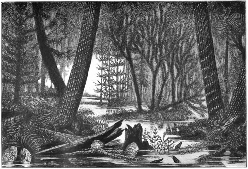
Ideal Landscape of the Carboniferous Period
Showing Lepidodendra and other Giant Ferns and Mosses whose remains are found in the Coal-Measures
Unfortunately, the phenomena of recent volcanic eruptions under the sea are for the most part inaccessible. Here and there, as in the Bay of Naples, at Etna, among the islands of the Greek Archipelago, and at Tahiti, elevation of the sea-bed has taken place, and brought to the surface beds of tuff or of lava, which have consolidated under water. Both Vesuvius and Etna began their career as submarine volcanoes. The Islands of Santorin and Therasia form the unsubmerged portions of a great crater-rim rising round a crater which descends 1,278 feet below sea-level.
Confining attention to vents now active, of which the total number may be about 300, the chief facts regarding their distribution over the globe may be thus summarized. (1) Volcanoes occur along the margins of the ocean-basins, particularly along lines of dominant mountain ranges, which either form part of the mainland of the continents or extend as adjacent lines of islands. The vast hollow of the Pacific is girdled with a wide ring of volcanic foci. (2) Volcanoes rise, as a striking feature, from the submarine ridges that traverse the ocean basins. All the oceanic islands are either volcanic or formed of coral, and the scattered coral-islands have in all likelihood been built upon the tops of submarine volcanic cones. (3) Volcanoes are situated not far from the sea. The only exceptions to this rule are certain vents in Manchuria and in the tract lying between Tibet and Siberia; but of the actual nature of these vents very little is yet known. (4) The dominant arrangement of volcanoes is in series along subterranean lines of weakness, as in the chain of the Andes, the Aleutian Islands, and the Malay Archipelago. A remarkable zone of volcanic vents girdles the globe from Central America eastward by the Azores and Canary Islands to the Mediterranean, thence to the Red Sea, and through the chains of islands from the south of Asia to New Zealand and the heart of the Pacific. (5) On a smaller scale the linear arrangement gives place to one in groups, as in Italy, Iceland, and the volcanic islands of the great oceans.
In the European area there are six active volcanoes—Vesuvius, Etna, Stromboli, Volcano, Santorin, and Nisyros. Asia contains twenty-four, Africa ten, North America twenty, Central America twenty-five, and South America thirty-seven. By much the larger number, however, occur on islands in the ocean. In the Arctic Ocean rises the solitary Jan Mayen. On the ridge separating the Arctic and Atlantic basins, the group of Icelandic volcanoes is found. Along the great central ridge of the Atlantic bottom, numerous volcanic vents have risen above the surface of the sea—the Azores, Canary Islands, and the extinct degraded volcanoes of St. Helena, Ascension, and Tristan d’Acunha. On the eastern border lie the volcanic vents of the islands off the African coast, and to the west those of the West Indian Islands. Still more remarkable is the development of volcanic energy in the Pacific area. From the Aleutian Islands southward, a long line of volcanoes, numbering upward of a hundred active vents, extends through Kamtchatka and the Kurile Islands to Japan, whence another numerous series carries the volcanic band far south toward the Malay Archipelago, which must be regarded as the chief centre of the present volcanic activity of our planet. In Sumatra, Java, and adjoining islands, no fewer than fifty active vents occur. The chain is continued through New Guinea and the groups of islands to New Zealand. Even in the Antarctic regions, Mounts Erebus and Terror are cited as active vents; while in the centre of the Pacific Ocean rise the great lava cones of the Sandwich Islands. In the Indian Ocean, the Red Sea, and off the east coast of Africa a few scattered vents appear.
THOUGHTS ABOUT KRAKATOA —Sir Robert S. Ball
Midway between Sumatra and Java lies a group of small islands, which, prior to 1883, were beautified by the dense forests and glorious vegetation of the tropics. Of these islands Krakatoa was the chief, though even of it but little was known. Its appearance from the sea must, indeed, have been familiar to the crews of the many vessels that navigated the Straits of Sunda, but it was not regularly inhabited. Glowing with tropical verdure, such an island seemed an unlikely theatre for the display of an unparalleled effect of plutonic energy, but yet there were certain circumstances which may tend to lessen our surprise at the outbreak. In the first place, as Professor Judd has so clearly pointed out, not only is Krakatoa situated in a region famous, or perhaps infamous, for volcanoes and earthquakes, but it actually happens to lie at the intersection of two main lines, along which volcanic phenomena are, in some degree, perennial. In the second place, history records that there have been previous eruptions at Krakatoa. The last of these appears to have occurred in May, 1680, but unfortunately only imperfect accounts of it have been preserved. It seems, however, to have annihilated the forests of the island, and to have ejected vast quantities of pumice, which cumbered the seas around. Krakatoa then remained active for a year and a half, after which the mighty fires subsided. The irrepressible tropical vegetation again resumed possession. The desolated islet again became clothed with beauty, and for a couple of centuries reposed in peace.
It was one o’clock in the afternoon of Sunday, August 26, 1883, when Krakatoa commenced a series of gigantic volcanic efforts. Detonations were heard which succeeded each other at intervals of about ten minutes. These were loud enough to penetrate as far as Batavia and Buitenzorg, distant 96 and 100 miles respectively from the volcano. A vast column of steam, smoke, and ashes ascended to a prodigious elevation. It was measured at two P. M. from a ship 76 miles away, and was then judged to be 17 miles high—that is, three times the height of the loftiest mountain in the world. As the Sunday afternoon wore on, the volcanic manifestations became ever fiercer. At 3 P. M. the sounds were loudly heard in a town 150 miles away. At 5 P. M. every ear in the island of Java was engaged in listening to volcanic explosions, which were considered to be of quite unusual intensity even in that part of the world. These phenomena were, however, only introductory. Krakatoa was gathering strength. Between 5 and 6 P. M. the British ship Charles Bal, commanded by Captain Watson, was about ten miles south of the volcano. The ship had to shorten sail in the darkness, and a rain of pumice, in large pieces and quite warm, fell upon her decks. At 7 P. M. the mighty column of smoke is described as having the shape of a pine tree, and as being brilliantly illuminated by electric flashes. The sulphurous air is laden with fine dust, while the lead dropped from a ship in its anxious navigation astounds the leadsman by coming up hot from the bottom of the sea. From sunset on Sunday till midnight the tremendous detonations followed each other so quickly that a continuous roar may be said to have issued from the island. The full terrors of the eruption were now approaching. The distance of 96 miles between Krakatoa and Batavia was not sufficient to permit the inhabitants of the town to enjoy their night’s sleep. All night long the thunders of the volcano sounded like the discharges of artillery at their very doors, while the windows rattled with aerial vibrations.
On Monday morning, August 27, the eruption culminated in four terrific explosions, of which the third, shortly after 10 A. M. Krakatoa time, was by far the most violent. The quantity of material ejected was now so great that darkness prevailed even as far as Batavia soon after 11 A. M., and there was a rain of dust until three in the afternoon. The explosions continued with more or less intensity all the afternoon of Monday and throughout Monday night. They finally ceased at about 2:30 A. M. on Tuesday, August 28. The entire series of grand phenomena thus occupied a little more than thirty-six hours.
It seems to be certain that if all the materials poured forth from Krakatoa during the critical period could be collected together, the mass they would form would be considerably over a cubic mile in volume. It is in the other standards of comparison that the importance of the explosion of Krakatoa is to be sought. The intensity of this outbreak in its last throes was such that mighty sounds were heard and mighty waves arose in the sea for which we can find no parallel. Every part of our globe’s surface felt the pulse of the air-waves, and beautiful optical phenomena made the circuit of the globe even more than once or twice. In these last respects the eruption of Krakatoa is unique.
It appears to me that the most remarkable incident connected with the eruption of Krakatoa was the production of the great air-wave by that particular explosion that occurred at ten o’clock on the morning of Monday, August 27. The great air-wave was truly of cosmical importance, affecting as it did every particle of the atmosphere on our globe.
The comprehensive series of phenomena wherein the atmosphere of the entire globe participates in an organized vibration has, so far as we know, only once been witnessed, and that was after the greatest outbreak at Krakatoa, at ten o’clock on the morning of August 27. But the ebb and the flow of these mighty undulations are not immediately appreciable to the senses. The great wave, for instance, passed and re-passed and passed again over London, and no inhabitant was conscious of the fact. But the automatic records of the barometer at Greenwich show that the vibration from Krakatoa to its antipodes, and from the antipodes back to Krakatoa, was distinctly perceptible over London not less than six or seven times.
From all parts of Europe, from Berlin to Palermo, from St. Petersburg to Valencia, we obtain the same indications. Fortunately self-recording barometric instruments are now to be found all over the world. Almost all the instruments show distinctly the first great wave from Krakatoa to its antipodes in Central America, and the return wave from the antipodes to Krakatoa. They also all show the second great wave which sped from Krakatoa, as well as the second great wave which returned from the antipodes. Thus, the first four of the oscillations are depicted on upward of forty of the barograms. The fifth and sixth oscillations are also to be distinguished on several of the curves, and even the seventh is certainly established at some few places, of which Kew is one. Then the gradually increasing faintness of the indications renders them unrecognizable, from which we conclude that after seven pulsations our atmosphere had sensibly regained its former condition ere it was disturbed by Krakatoa.
In the whole annals of noise there is nothing which can be compared to the records. Lloyd’s agent at Batavia, 94 miles distant, says that on the morning of August 27 the reports and concussions were deafening. At Carimon, Java Island, reports were heard which led to the belief that some vessel offshore was making signals of distress, and boats were accordingly put out to render succor, but no vessel was found, as the reports were from Krakatoa, at a distance of 355 miles. At Macassar, in Celebes, explosions were heard all over the province. Two steamers were sent out to discover the cause, for the authorities did not then know that what they heard came from Krakatoa, 969 miles away. But mere hundreds of miles will not suffice to exemplify the range of this stupendous siren. In St. Lucia Bay, in Borneo, a number of natives, who had been guilty of murder, thought they heard the sounds of vengeance in the approach of an attacking force. They fled from their village, little fancying that what alarmed them really came from Krakatoa, 1,116 miles distant. All over the island of Timor alarming sounds were heard, and so urgent did the situation appear that the government was aroused, and sent off a steamer to ascertain the cause. The sounds had, however, come 1,351 miles, all the way from Krakatoa. In the Victoria Plains of West Australia the inhabitants were startled by the discharge of artillery—an unwonted noise in that peaceful district—but the artillery was at Krakatoa, 1,700 miles distant. The inhabitants of Daly Waters, in South Australia, were rudely awakened at midnight on Sunday, August 26, by an explosion resembling the blasting of a rock, which lasted for a few minutes. The time and other circumstances show that here again was Krakatoa heard, this time at the monstrous distance of 2,023 miles. But there is undoubted testimony that to distances even greater than 2,023 miles the waves of sound conveyed tidings of the mighty convulsion. Diego Garcia, in the Chagos Islands, is 2,267 miles from Krakatoa, but the thunders traversed even this distance, and created the belief that there must be some ship in distress, for which a diligent but necessarily ineffectual search was made. To pass at once to the most remarkable case of all, we have a report from Mr. James Wallis, chief of police in Rodriguez, that “several times during the night of August 26-27, 1883, reports were heard coming from the eastward, like the distant roar of heavy guns. These reports continued at intervals of between three and four hours.” We have thus the astounding fact that almost across the whole wide extent of the Indian Ocean, that is, to a distance of nearly 3,000 miles (2,968), the sound of the throes of Krakatoa was propagated.
I shall content myself with the mention of three facts in illustration of the great sea waves which accompanied the eruption of Krakatoa. Of these, probably the most unusual is the magnitude of the area over which the undulations were perceived. Thus, to mention but a single instance, and that not by any means an extreme one, we find that the tide gauge at Table Bay reveals waves which, notwithstanding that they have traveled 5,100 miles from Krakatoa, have still a range of eighteen inches when they arrive at the southern coast of Africa. The second fact that I mention illustrates the magnitude of the seismic waves by the extraordinary inundations that they produced on the shores of the Straits of Sunda. Captain Wharton shows that the waves, as they deluged the land, must have been fifty feet, or, in one well authenticated case, seventy-two feet high. It was, of course, these vast floods which caused the fearful loss of life. The third illustrative fact concerns the fate of a man-of-war, the Berouw. This unhappy vessel was borne from its normal element and left high and dry in Sumatra, a mile and three-quarters inland, and thirty feet above the level of the sea.
During the crisis on August 26-27, the volume of material blown into the air was sufficiently dense to obscure the coasts of Sumatra to such a degree that at 10 A. M. the darkness there is stated to have been more intense than it is even in the blackest of nights. The fire-dust ascended to an elevation which, as we have already mentioned, is estimated to have been as much as seventeen miles. Borne aloft into these higher regions of our atmosphere, the clouds of dust at once became the sport of the winds and the currents which may be found there. If we had not previously known the prevailing tendency of the winds at these elevations and in these latitudes, the journey of the Krakatoa dust would have taught us.
It seems certain that, having attained their lofty elevation, the mighty clouds of dust were seized by easterly winds, and were swept along with a velocity which may not improbably be normal at a height of twenty miles above the earth’s surface.
It appears that this cloud of dust started immediately from Krakatoa for a series of voyages round the world. The highway which it at first pursued may, for our present purpose, be sufficiently defined by the Tropic of Cancer and the Tropic of Capricorn, though it hardly approached these margins at first. Westward the dust of Krakatoa takes its way. In three days it had crossed the Indian Ocean and was rapidly flying over the heart of Equatorial Africa; for another couple of days it was making a transatlantic journey; and then it might be found, for still a couple of days more, over the forests of Brazil ere it commenced the great Pacific voyage which brought it back to the East Indies. The dust of Krakatoa had put a girdle round the earth in thirteen days! The shape of the cloud appears to have been elongated, so that it took two or three days to complete the passage over any stated place.
It remains to give some brief account of the optical phenomena due to the presence of dust, unusual both in quantity and in character, in the upper atmosphere. Beautiful pictures show the twilight and after-glow effects as seen by Mr. W. Ascroft on the bank of the Thames a little west of London, on the evening of November 26, 1883. Analogous phenomena were seen almost universally during November and December in the same year. Who is there that does not remember the wondrous loveliness of the twilights and the after-glows during that remarkable winter! These appearances at sunrise and sunset are only the more generally recognized of a whole system of strange optical phenomena. One of the most striking indications of the presence of the dust-stream in its first voyage round the earth was given by the strange blue hue it imparted to the sun. The dust-stream was also visible in its rapid voyages as a lofty haze or extensive cloud of cirro-stratus. Then, too, strange halos were often seen, there were occasional blue or green moons, and the sun was sometimes glorified by a corona that had its origin in our atmosphere. Everywhere in the world there were remarkable features in the sky that winter: from Tierra del Fuego to Lake Superior; from China to the Gulf of Guinea; from Panama to Australia. Wherever on land there were inhabitants with sufficient intelligence to note the unusual, wherever on the sea there were mariners who kept a careful log, from all such observers we learn that in the autumn and winter months following the great eruption of Krakatoa, there were extraordinary manifestations witnessed in the heavens.
VOLCANOES —Sir Archibald Geikie
The term volcanic action (volcanism or volcanicity) embraces all the phenomena connected with the expulsion of heated materials from the interior of the earth to the surface. Among these phenomena, some possess an evanescent character, while others leave permanent proofs of their existence. It is naturally to the latter that the geologist gives chief attention, for it is by their means that he can trace former phases of volcanic activity in regions where, for many ages, there have been no volcanic eruptions. In the operations of existing volcanoes, he can observe only superficial manifestations of volcanic action. But examining the rocks of the earth’s crust, he discovers that amid the many terrestrial revolutions which geology reveals, the very roots of former volcanoes have been laid bare, displaying subterranean phases of volcanism which could not be studied in any modern volcano. Hence an acquaintance only with active volcanoes will not afford a complete knowledge of volcanic action. It must be supplemented and enlarged by an investigation of the traces of ancient volcanoes preserved in the crust of the earth.
The word “volcano” is applied to a conical hill or mountain (composed mainly or wholly of erupted materials), from the summit and often also from the sides of which hot vapors issue, and ashes and streams of molten rock are intermittently expelled. The term “volcanic” designates all the phenomena essentially connected with one of these channels of communication between the surface and the heated interior of the globe. Yet there is good reason to believe that the active volcanoes of the present day do not afford by any means a complete type of volcanic action. The first effort in the formation of a new volcano is to establish a fissure in the earth’s crust. A volcano is only one vent or group of vents established along the line of such a fissure. But in many parts of the earth, alike in the Old World and the New, there have been periods in the earth’s history when the crust was rent into innumerable fissures over areas thousands of square miles in extent, and when the molten rock, instead of issuing, as it does at a modern volcano, in narrow streams from a central elevated cone, welled out from numerous small vents along the rents, and flooded enormous tracts of country without forming any mountain or conspicuous volcanic cone in the usual sense of these terms. Of these “fissure-eruptions,” apart from central volcanic cones, no examples appear to have occurred within the times of human history, except in Iceland, where vast lava-floods issued from a fissure in 1783. They can best be studied from the remains of former convulsions.
The materials erupted from volcanic vents may be classed as (1) gases and vapors, (2) water, (3) lava, (4) fragmentary substances.
Gases and vapors exist dissolved in the molten magma within the earth’s crust. They play an important part in volcanic activity, showing themselves in the earliest stages of a volcano’s history, and continuing to appear for centuries after all other subterranean action has ceased. By much the most abundant of them all is water-gas, which, ultimately escaping as steam, has been estimated to form 999-1000ths of the whole cloud that hangs over an active volcano. In great eruptions, steam rises in prodigious quantities, and is rapidly condensed into a heavy rainfall. M. Fouqué calculated that, during 100 days, one of the parasitic cones on Etna had ejected vapor enough to form, if condensed, 2,100,000 cubic metres (462,000,000 gallons) of water. But even from volcanoes which, like the Solfatara of Naples, have been dormant for centuries, steam sometimes still rises without intermission and in considerable volume. Jets of vapor rush out from clefts in the sides and bottom of a crater with a noise like that made by the steam blown off by a locomotive. The number of these funnels or “fumaroles” is often so large, and the amount of vapor so abundant, that only now and then, when the wind blows the dense cloud aside, can a momentary glimpse be had of a part of the bottom of the crater; while at the same time the rush and roar of the escaping steam remind one of the din of some vast factory. Aqueous vapor rises likewise from rents on the outside of the volcanic cone. It issues so copiously from some flowing lavas that the stream of rock may be almost concealed from view by the cloud; and it continues to escape from fissures of the lava, far below the point of exit, for a long time after the rock has solidified and come to rest.
Abundant discharges of water accompany some volcanic explosions. Three sources of this water may be assigned: (1) from the melting of snow by a rapid accession of temperature previous to or during an eruption; this takes place from time to time on Etna, in Iceland, and among the snowy ranges of the Andes, where the cone of Cotopaxi is said to have been entirely divested of its snow in a single night by the heating of the mountain; (2) from the condensation of the vast clouds of steam which are discharged during an eruption; this undoubtedly is the chief source of the destructive torrents so frequently observed to form part of the phenomena of a great volcanic explosion; and (3) from the disruption of reservoirs of water filling subterranean cavities, or of lakes occupying crater-basins; this has several times been observed among the South American volcanoes, where immense quantities of dead fish, which inhabited the water, have been swept down with the escaping torrents. The volcano of Agua in Guatemala received its name from the disruption of a crater-lake at its summit by an earthquake in 1540, whereby a vast and destructive debacle of water was discharged down the slopes of the mountain. In the beginning of the year 1817, an eruption took place at the large crater of Idjèn, one of the volcanoes of Java, whereby a steaming lake of hot acid water was discharged with frightful destruction down the slopes of the mountain. After the explosion, the basin filled again with water, but its temperature was no longer high.
The term lava is applied generally to all the molten rocks of volcanoes. The use of the word in this broad sense is of great convenience in geological descriptions, by directing attention to the leading character of the rocks as molten products of volcanic action, and obviating the confusion and errors which are apt to arise from an ill-defined or incorrect lithological terminology.
While still flowing or not yet cooled, lavas differ from each other in the extent to which they are impregnated with gases and vapors. Some appear to be saturated, others contain a much smaller gaseous impregnation; and hence arise important distinctions in their behavior. After solidification, lavas present some noticeable characters, then easily ascertainable. (1) Their average specific gravity may be taken as ranging between 2.37 and 3.22. (2) The heavier varieties contain much magnetic or titaniferous iron, with augite and olivine, their composition being basic, and their proportion of silica averaging about 45 to 55 per cent. (3) Lavas differ much in structure and texture. (4) Lavas vary greatly in color and general external aspect. The heavy basic kinds are usually dark gray, or almost black, though, on exposure to the weather, they acquire a brown tint from the oxidation and hydration of their iron. Their surface is commonly rough and ragged, until it has been sufficiently decomposed by the atmosphere to crumble into soil which, under favorable circumstances, supports a luxuriant vegetation. The less dense lavas, such as phonolites and trachytes, are frequently paler in color, sometimes yellow or buff, and decompose into light soils; but the obsidians present rugged black sheets of rock, roughened with ridges and heaps of gray froth-like pumice. Some of the most brilliant surfaces of color in any rock-scenery on the globe are to be found among volcanic rocks. The walls of active craters glow with endless hues of red and yellow. The Grand Cañon of the Yellowstone River has been dug out of the most marvelously tinted lavas and tuffs.
Volcanic action may be either constant or periodic. Stromboli, in the Mediterranean, so far as we know, has been uninterruptedly emitting hot stones and steam, from a basin of molten lava, since the earliest period of history. Among the Moluccas, the volcano Sioa, and in the Friendly Islands, that of Tofua, have never ceased to be in eruption since their first discovery. The lofty cone of Sangay, among the Andes of Quito, is always giving off hot vapors; Cotopaxi, too, is ever constantly active. But, though examples of unceasing action may thus be cited from widely different quarters of the globe, they are nevertheless exceptional. The general rule is that a volcano breaks out from time to time with varying vigor, and after longer or shorter intervals of quiescence.
It is usual to class volcanoes as active, dormant, and extinct. This arrangement, however, often presents considerable difficulty in its application. An active volcano can not of course be mistaken, for even when not in eruption, it shows by its discharge of steam and hot vapors that it might break out into activity at any moment. But in many cases it is impossible to decide whether a volcano should be called extinct or only dormant. The volcanoes of Silurian age in Wales, of Carboniferous age in Ireland, of Permian age in the Harz, of Miocene age in the Hebrides, of younger Tertiary age in the Western States and Territories of North America, are certainly all extinct. But the older Tertiary volcanoes of Iceland are still represented there by Skaptar-Jökull, Hecla, and their neighbors. Somma, in the First Century of the Christian era, would have been naturally regarded as an extinct volcano. Its fires had never been known to have been kindled; its vast crater was a wilderness of wild vines and brushwood, haunted, no doubt, by wolf and wild boar. Yet in a few days, during the autumn of the year 79, the half of the crater walls was blown out by a terrific series of explosions, the present Vesuvius was then formed within the limits of the earlier crater, and since that time volcanic action has been intermittently exhibited up to the present day. Some of the intervals of quietude, however, have been so considerable that the mountain might then again have been claimed as an extinct volcano. Thus, in the 131 years between 1500 and 1631, so completely had eruptions ceased that the crater had once more become choked with copse-wood. A few pools and springs of very salt and hot water remained as memorials of the former condition of the mountain. But this period of quiescence closed with the eruption of 1631—the most powerful of all the known explosions of Vesuvius, except the great one of 79.
In short, no essential distinction can be drawn between dormant and extinct volcanoes. Volcanic action is apt to show itself again and again, even at vast intervals, within the same regions and over the same sites. The dormant or waning condition of a volcano, when only steam and various gases and sublimates are given off, is sometimes called the Solfatara phase, from the well-known dormant crater of that name near Naples.
The interval between two eruptions of an active volcano shows a gradual augmentation of energy. The crater, emptied by the last discharge, has its floor slowly upraised by the expansive force of the lava-column underneath. Vapors rise in constant outflow, accompanied sometimes by discharges of dust or stones. Through rents in the crater-floor red-hot lava may be seen only a few feet down. Where the lava is maintained at or above its fusion-point and possesses great liquidity, it may form boiling lakes, as in the great crater of Kilauea, where acres of seething lava may be watched throwing up fountains of molten rock, surging against the walls and re-fusing large masses that fall into the burning flood. The lava-column inside the pipe of a volcano is all this time gradually rising, until some weak part of the wall allows it to escape, or until the pressure of the accumulated vapors becomes great enough to burst through the hardened crust of the crater-floor and give rise to the phenomena of an eruption.
Kluge has sought to trace a connection between the years of maximum and minimum sun-spots and those of greatest and feeblest volcanic activity, and has constructed lists to show that years which have been specially characterized by terrestrial eruptions have coincided with those marked by few sun-spots and diminished magnetic disturbance. Such a connection can not be regarded as having yet been satisfactorily established. Again, the same author has called attention to the frequency and vigor of volcanic explosions at or near the time of the August meteoric shower. But in this case, likewise, the cited examples can hardly yet be looked upon as more than coincidences.
At many volcanic vents the eruptive energy manifests itself with more or less regularity. At Stromboli, which is constantly in an active state, the explosions occur at intervals varying from three or four to ten minutes and upward. A similar rhythmical movement has been often observed during the eruptions at other vents which are not constantly active. Volcano, for example, during its eruption of September, 1873, displayed a succession of explosions which followed each other at intervals of from twenty to thirty minutes. At Etna and Vesuvius a similar rhythmical series of convulsive efforts has often been observed during the course of an eruption. Among the volcanoes of the Andes a periodic discharge of steam has been observed; Mr. Whymper noticed outrushes of steam to proceed at intervals of from twenty to thirty minutes from the summit of Sangai, while during his inspection of the great crater of Cotopaxi, this volcano was seen to blow off steam at intervals of about half an hour. At the eruption of the Japanese volcano, Oshima, in 1877, Mr. Milne observed that the explosions occurred nearly every two seconds, with occasional pauses of 15 or 20 seconds. Kilauea, in Hawaii, seems to show a regular system of grand eruptive periods. Dana has pointed out that outbreaks of lava have taken place from that volcano at intervals of from eight to nine years, this being the time required to fill the crater up to the point of outbreak, or to a depth of 400 or 500 feet.
The approach of an eruption is not always indicated by any premonitory symptoms, for many tremendous explosions are recorded to have taken place in different parts of the world without perceptible warning. Much in this respect would appear to depend upon the condition of liquidity of the lava, and the amount of resistance offered by it to the passage of the escaping vapors through its mass. In Hawaii, where the lavas are remarkably liquid, vast outpourings of them have taken place quietly without earthquakes during the present century. But even there the great eruption of 1868 was accompanied by violent earthquakes.
The eruptions of Vesuvius are often preceded by failure or diminution of wells and springs. But more frequent indications of an approaching outburst are conveyed by sympathetic movements of the ground. Subterranean rumblings and groanings are heard; slight tremors succeed, increasing in frequency and violence till they become distinct earthquake shocks. The vapors from the crater grow more abundant as the lava-column in the pipe or funnel of the volcano ascends, forced upward and kept in perpetual agitation by the passage of elastic vapors through its mass. After a long previous interval of quiescence, there may be much solidified lava toward the top of the funnel, which will restrain the ascent of the still molten portion underneath. A vast pressure is thus exercised on the sides of the cone, which, if too weak to resist, will open in one or more rents, and the liquid lava will issue from the outer slope of the mountain; or the energies of the volcano will be directed toward clearing the obstruction in the chief throat, until with tremendous explosions, and the rise of a vast cloud of dust and fragments, the bottom and sides of the crater are finally blown out, and the top of the cone disappears. The lava may now escape from the lowest part of the lip of the crater, while, at the same time, immense numbers of red-hot bombs, scoriæ, and stones are shot up into the air. The lava at first rushes down like one or more rivers of melted iron, but, as it cools, its rate of motion lessens. Clouds of steam rise from its surface, as well as from the central crater. Indeed, every successive paroxysmal convulsion of the mountain is marked, even at a distance, by the rise of huge ball-like wreaths or clouds of steam, mixed with dust and stones, forming a column which towers sometimes a couple of miles or more above the summit of the cone. By degrees these eructations diminish in frequency and intensity. The lava ceases to issue, the showers of stones and dust decrease, and after a time, which may vary from hours to days or months, even in the régime of the same mountain, the volcano becomes once more tranquil.
The convulsions which culminate in the formation of a volcano usually split open the terrestrial crust by a more or less nearly rectilinear fissure, or by a system of fissures. In the subsequent progress of the mountain, the ground at and around the focus of action is liable to be again and again rent open by other fissures. These tend to diverge from the focus; but around the vent where the rocks have been most exposed to concussion, the fissures sometimes intersect each other in all directions. In the great eruption of Etna, in the year 1669, a series of six parallel fissures opened on the side of the mountain. One of these, with a width of two yards, ran for a distance of 12 miles, in a somewhat winding course, to within a mile of the top of the cone.
In the deeper portions of a volcanic vent the convulsive efforts of the lava-column to force its way upward must often produce lateral as well as vertical rifts, and into these the molten material will rush, exerting as it goes an enormous upward pressure on the mass of rock overlying it. At a modern volcano these subterranean manifestations can not be seen, but among the volcanoes of Tertiary and older times they have been revealed by the progress of denudation.
Though lava very commonly issues from the lateral fissures on a volcanic cone, it may sometimes approach the surface in them without actually flowing out. The great fissure on Etna in 1669, for example, was visible even from a distance, by the long line of vivid light which rose from the incandescent lava within. Again, it frequently happens that minor volcanic cones are thrown up on the line of a fissure, either from the congelation of the lava round the point of emission, or from the accumulation of ejected scoriæ round the fissure-vent. One of the most remarkable examples of this kind is that of the Laki fissure in Iceland, the whole length of which (12 miles) bristles with small cones and craters almost touching each other.
Apart from the appearance of visible fissures, volcanic energy may be, as it were, concentrated on a given point, which will usually be the weakest in the structure of that part of the terrestrial crust, and from which the solid rock, shattered into pieces, is hurled into the air by the enormous expansive energy of the volcanic vapors. The history of the cone of Vesuvius brings before us a long series of such explosions, beginning with that of A. D. 79, and coming down to the present day. Even now, in spite of all the lava and ashes poured out during the last eighteen centuries, it is easy to see how stupendous must have been that earliest explosion by which the southern half of the ancient crater was blown out. At every successive important eruption, a similar but minor operation takes place within the present cone. The hardened cake of lava forming the floor is burst open, and with it there usually disappears much of the upper part of the cone, and sometimes, as in 1872, a large segment of the crater-wall. The islands of Santorin bring before us evidence of a prehistoric catastrophe of a similar nature, by which a large volcanic cone was blown up. The existing outer islands are a chain of fragments of the periphery of the cone, the centre of which is now occupied by the sea. In the year 1538 a new volcano, Monte Nuovo, was formed in twenty-four hours on the margin of the Bay of Naples. An opening was drilled by successive explosions, and such quantities of stones, scoriæ, and ashes were thrown out from it as to form a hill that rose 440 English feet above the sea-level, and was more than a mile and a half in circumference.
A communication having been opened, either by fissuring or explosion, between the heated interior and the surface, fragmentary materials are commonly ejected from it, consisting at first mainly of the rocks through which the orifice has been opened, afterward of volcanic substances. In a great eruption, vast numbers of red-hot stones are shot up into the air, and fall back partly into the crater and partly on the outer slopes of the cone. According to Sir W. Hamilton, cinders were thrown by Vesuvius, during the eruption of 1779, to a height of 10,000 feet. Instances are known where large stones, ejected obliquely, have described huge parabolic curves in the air, and fallen at a great distance. Stones eight pounds in weight occur among the ashes which buried Pompeii. The volcano of Antuco in Chili is said to send stones flying to a distance of thirty-six miles, Cotopaxi is reported to have hurled a 200-ton block nine miles, and the Japanese volcano, Asama, is said to have ejected many blocks of stone measuring from 40 to more than 100 feet in diameter.
But in many great eruptions, besides a constant shower of stones and scoriæ, a vast column of exceedingly fine dust rises out of the crater, sometimes to a height of several miles, and then spreads outward like a sheet of cloud. The remarkable fineness of this dust may be understood from the fact that during great volcanic explosions no boxes, watches, or close-fitting joints have been found to be able to exclude it. Mr. Whymper collected some dust that fell sixty-five miles away from Cotopaxi, and which was so fine that from 4,000 to 25,000 particles were required to weigh a grain. So dense is the dust-cloud as to obscure the sun, and for days together the darkness of night may reign for miles around the volcano. The eruption of Cotopaxi, on 26th June, 1877, began by an explosion that sent up a column of fine ashes to a prodigious height into the air, where it rapidly spread out and formed so dense a canopy as to throw the region below it into total darkness. So quickly did it diffuse itself, that in an hour and a half a previously bright morning became at Quito, thirty-three miles distant, a dim twilight, which in the afternoon passed into such darkness that the hand placed before the eye could not be seen. At Guayaquil, on the coast, 150 miles distant, the shower of ashes continued till the 1st of July. Dr. Wolf collected the ashes daily, and estimated that at that place there fell 315 kilogrammes on every square kilometre during the first thirty hours, and on the 30th of June, 209 kilogrammes in twelve hours.
One of the most stupendous outpourings of volcanic ashes on record took place, after a quiescence of twenty-six years, from the volcano Coseguina, in Nicaragua, during the early part of the year 1835. On that occasion, utter darkness prevailed over a circle of thirty-five miles radius, the ashes falling so thickly that, even eight leagues from the mountain, they covered the ground to a depth of about ten feet. It was estimated that the rain of dust and sand fell over an area at least 270 geographical miles in diameter. Some of the finer materials, thrown so high as to come within the influence of an upper air-current, were borne away eastward, and fell, four days afterward, at Kingston, in Jamaica—a distance of 700 miles. During the great eruption of Sumbawa, in 1815, the dust and stones fell over an area of nearly one million square miles, and were estimated by Zollinger to amount to fully fifty cubic miles of material, and by Junghuhn to be equal to one hundred and eighty-five mountains like Vesuvius. Toward the end of the Eighteenth Century, during a time of great disturbance among the Japanese volcanoes, one of them, Sakurajima, threw out so much pumiceous material that it was possible to walk a distance of twenty-three miles upon the floating débris in the sea.
The varying degree of liquidity or viscosity of the lava probably modifies the force of explosions, owing to the different amounts of resistance offered to the upward passage of the absorbed gases and vapors. Thus explosions and accompanying scoriæ are abundant at Vesuvius, where the lavas are comparatively viscid; they are almost unknown at Kilauea, where the lava is remarkably liquid.
In tranquil conditions of a volcano, the steam, whether collecting into larger or smaller vesicles, works its way upward through the substance of the molten lava, and as the elasticity of this compressed vapor overcomes the pressure of the overlying lava, it escapes at the surface, and there the lava is thus kept in ebullition. But this comparatively quiet operation, which may be watched within the craters of many active volcanoes, does not produce clouds of fine dust. The collision or friction of millions of stones ascending and descending in the dark column above the crater must doubtless cause much dust and sand. But the explosive action of steam is probably also an immediate cause of much trituration. The aqueous vapor or water-gas which is so largely dissolved in many lavas must exist within the lava-column, under an enormous pressure, at a temperature far above its critical point, even at a white heat, and therefore possibly in a state of dissociation. The sudden ascent of lava so constituted relieves the pressure rapidly without sensibly affecting the temperature of the mass. Consequently, the white-hot gases or vapors at length explode, and reduce the molten mass to the finest powder, like water shot out of a gun.
As every shower of dust and sand adds to the height of the ground on which it falls, thick volcanic accumulations may be formed far beyond the base of the mountain. The volcano of Sangay, in Ecuador, for instance, has buried the country around it to a depth of 4,000 feet under its ashes. In such loose deposits are entombed trees and other kinds of vegetation, together with the bodies of animals, as well as the works of man. In some cases, where the layer of volcanic dust is thin, it may merely add to the height of the soil, without sensibly interfering with the vegetation. But it has been observed at Santorin that though this is true in dry weather, the fall of rain with the dust at once acts detrimentally. On the 3d of June, 1866, the vines were there withered up, as if they had been burned, along the track of the smoke cloud. By the gradual accumulation of volcanic ashes, new geological formations arise which, in their component materials, not only bear witness to the volcanic eruptions that produced them, but preserve a record of the land-surfaces over which they spread. In the third place, besides the distance to which the fragments may be hurled by volcanic explosions, or to which they may be diffused by the ordinary aerial movements, we have to take into account the vast spaces across which the finer dust is sometimes borne by upper air-currents. In the instance already cited, ashes from Coseguina fell 700 miles away, having been carried all that long distance by a high counter-current of air, moving apparently at the rate of about seven miles an hour in an opposite direction to that of the wind which blew at the surface. By the Sumbawa eruption, also referred to above, the sea west of Sumatra was covered with a layer of ashes two feet thick. On several occasions ashes from the Icelandic volcanoes have fallen so thickly between the Orkney and Shetland Islands, that vessels passing there have had the unwonted deposit shoveled off their decks in the morning. In the year 1783, during the memorable eruption of Skaptar-Jökull, so vast an amount of fine dust was ejected that the atmosphere over Iceland continued loaded with it for months afterward. It fell in such quantities over parts of Caithness—a distance of 600 miles—as to destroy the crops; that year is still spoken of by the inhabitants as the year of “the ashie.” Traces of the same deposit have been observed in Norway, and even as far as Holland. Hence it is evident that volcanic accumulations may take place in regions many hundreds of miles distant from any active volcano. A single thin layer of volcanic detritus in a group of sedimentary strata would not thus of itself prove the existence of contemporaneous volcanic action in its neighborhood.