I.—THE EARTH’S CRUST (continued 3)
Reading edition
At its exit from the side of a volcano, lava glows with a white heat, and flows with a motion which has been compared to that of honey or of melted iron. It soon becomes red, and like a coal fallen from a hot fireplace rapidly grows dull as it moves along, until it assumes a black, cindery aspect. At the same time the surface congeals, and soon becomes solid enough to support a heavy block of stone. The aspect of the stream varies with the composition and fluidity of the lava, form of the ground, angle of slope, and rapidity of flow. Viscous lavas, like those of Vesuvius, break up along the surface into rough brown or black cinder-like slags and irregular ragged cakes, bristling with jagged points, which, in their onward motion, grind and grate against each other with a harsh, metallic sound, sometimes rising into rugged mounds or becoming seamed with rents and gashes, at the bottom of which the red-hot glowing lava may be seen. In lavas possessing somewhat greater fluidity, the surface presents froth-like, curving lines, as in the scum of a slowly flowing river, or is arranged in curious ropy folds, as the layers have successively flowed over each other and congealed. A large area which has been flooded with lava is perhaps the most hideous and appalling scene of desolation anywhere to be found on the surface of the globe.
A lava-stream usually spreads out as it descends from its point of escape, and moves more slowly. Its sides look like huge embankments, or like some of the long mounds of “clinkers” in a great manufacturing district. The advancing end is often much steeper, creeping onward like a great wall or rampart, down the face of which the rough blocks of hardened lava are ever rattling.
In a lofty volcano, lava occasionally rises to the lip of the crater and flows out there; but more frequently it escapes from some fissure or orifice in a weak part of the cone. In minor volcanoes, on the other hand, where the explosions are less violent, and where the thickness of the cone in proportion to the diameter of the funnel is often greater, the lava very commonly rises into the crater. Should the crater-walls be too weak to resist the pressure of the molten mass, they give way, and the lava rushes out from the breach. This is seen to have happened in several of the puys of Auvergne. But if the crater be massive enough to withstand the pressure, the lava may at last flow out from the lowest part of the rim.
As soon as the molten rock reaches the surface, the superheated water-vapor or gas dissolved within its mass escapes copiously, and hangs as a dense white cloud over the moving current. The lava-streams of Vesuvius sometimes appear with as dense a steam-cloud at their lower ends as that which escapes at the same time from the main crater. Even after the molten mass has flowed several miles, steam continues to rise abundantly both from its end and from numerous points along its surface, and continues to do so for many weeks, months, or it may be for several years.
Should the point of escape of a lava-stream lie well down on the cone, far below the summit of the lava-column in the funnel, the molten rock, on its first escape, driven by hydrostatic pressure, will sometimes spout up high into the air—a fountain of molten rock. This was observed in 1794 on Vesuvius, and in 1832 on Etna. In the eruption of 1852 at Mauna Loa, an unbroken fountain of lava, from 200 to 700 feet in height and 1,000 feet broad, burst out at the base of the cone. Similar “geysers” of molten rock have subsequently been noticed in the same region. Thus in March and April, 1868, four fiery fountains, throwing lava to heights varying from 500 to 1,000 feet, continued to play for several weeks. According to Mr. Coan, such outbursts take place from the bottom of a column of lava 3,000 feet high. The volcano of Mauna Loa strikingly illustrates another feature of volcanic dynamics in the position and outflow of lava. It bears upon its flanks at a distance of 20 miles, but 10,000 feet lower, the huge crater Kilauea. As Dana has pointed out, these orifices form part of one mountain, yet the column of lava stands 10,000 feet higher in one conduit than in the other. On a far smaller scale the same independence occurs among the several pipes of some of the geysers in the Yellowstone region of North America.
The rate of movement is regulated by the fluidity of the lava, by its volume, and by the form and inclination of the ground. Hence, as a rule, a lava-stream moves faster at first than afterward, because it has not had time to stiffen, and its slope of descent is usually steeper than further down the mountain. One of the most fluid and swiftly flowing lava-streams ever observed on Vesuvius was that erupted on 12th August, 1805. It is said to have rushed down a space of 3 Italian (3⅔ English) miles in the first four minutes, but to have widened out and moved more slowly as it descended, yet finally to have reached Torre del Greco in three hours. A lava erupted by Mauna Loa in 1852 went as fast as an ordinary stage-coach, or fifteen miles in two hours; but some of the lavas from that mountain have in parts of their course moved with double that rapidity.
In some cases, lava escaping from craters or fissures comes to rest before reaching the base of the slopes, like the obsidian current which has congealed on the side of the little volcanic island of Volcano. In other instances, the molten rock not only reaches the plains, but flows for many miles away from the point of eruption. Sartorius von Waltershausen computed the lava emitted by Etna in 1865 at 92 millions of cubic metres, that of 1852 at 420 millions, that of 1669 at 980 millions, and that of a prehistoric lava-stream near Randazzo at more than 1,000 millions. The most stupendous outpouring of lava on record was that which took place in Iceland in the year 1783. Successive streams issued from a fissure about 12 miles long, filling up river gorges which were sometimes 600 feet deep and 200 feet broad, and advancing into the alluvial plains in lakes of molten rock 12 to 15 miles wide and 100 feet deep. Two currents of lava which, filling up the valley of the Skapta, escaped in nearly opposite directions, extended for 45 and 50 miles respectively, their usual thickness being 100 feet. Bischof estimated that the total amount of lava poured forth during this single eruption “surpassed in magnitude the bulk of Mont Blanc.”
The varying degrees of liquidity are manifested in a characteristic way on the surface of lava. Thus, in the great lava-pools of Hawaii, the rock exhibits a remarkable liquidity, throwing up fountains of molten rock to a height of 300 feet or more. During its ebullition in the crater-pools, jets and driblets a quarter of an inch in diameter are tossed up, and, falling back on one another, make “a column of hardened tears of lava,” one of which was found to have attained a height of 40 feet, while in other places the jets thrown up and blown aside by the wind give rise to long threads of glass which lie thickly together like mown grass, and are known by the natives under the name of “Pele’s Hair,” after one of their divinities. Yet, although the ebullition is caused by the uprise and escape of highly heated vapors, there is no cloud over the boiling lake itself, heavy white vapor only escaping at different points along the edge.
EARTHQUAKES —William Hughes
It appears, from the accurate records of such phenomena which have been kept within recent periods, that earthquakes are of much more frequent occurrence than is commonly supposed. Upward of three thousand earthquakes are recorded as having occurred within the first half of the Nineteenth Century—an average of more than one for every week throughout the entire period. But not more than one in forty is of considerable importance, by far the greater number consisting of such slight shocks as are occasionally experienced in Great Britain and other countries favored with a like immunity in this regard. An important earthquake, however, in some part of the world or other, appears, from the above average, to occur once in every eight months. In Europe alone, where a more complete record of such occurrences is obtainable than in other parts of the world, as many as 320 distinct earthquakes are recorded to have occurred within a period of ten years (1833-42)—an average of thirty-two annually, and of one such shock for every ten days throughout the period.
[The geographical area within which shocks of earthquakes are experienced is a widely spread one, and does not appear to undergo any material change (if, indeed, any change whatever) as to its limits. At any rate, the regions in which violent earthquakes are recorded to have occurred in former times are those in which such disturbances are of most frequent recurrence at the present day. One of the most striking evidences in favor of the supposition that the volcanic eruption is due to the same deeply seated cause which produces the shock of the earthquake, is afforded by the fact, that all the volcanoes which have been in eruption within the modern period of geology are found within regions liable to earthquakes, and, for the most part, to violent shocks.]
Regarding the earthquake and the volcanic eruption as the manifestation, under different conditions, of the earth’s internal fires, we readily mark out upon the globe the great regions of geographical distribution in the case of such phenomena. The most widely extended of these coincides with the circuit of the Pacific Ocean. Along the entire western coast of the New World, from Tierra del Fuego to the peninsula of Alaska and the neighborhood of the Aleutian Islands, shocks of earthquakes are known to occur; and, within a large portion of the space, vents of active eruption are found. The subterranean igneous force is, indeed, much more powerfully displayed in the southern than in the northern half of the American continent, and the active volcanoes that occur within the limits referred to are nearly all found amid the cordilleras of the Andes, or upon the plateaus of the Mexican isthmus. One of the Mexican volcanoes—Jorullo—is especially deserving of notice, from the circumstance of its having first risen above the surrounding plain by the accumulation of volcanic matter during an eruption in the year 1759.
The Aleutian Islands connect the volcanic region of the eastern Pacific with that which extends along its western shores. In the latter case, however, it is upon the peninsular regions, or in the chains of islands that adjoin the mainland, that the igneous force is displayed. Kamtchatka, the Kurile Islands, Yesso, the Japanese group, and the entire region of the Malay Archipelago, exhibit the presence of igneous force below the ground. Seven active volcanoes occur in Kamtchatka. The Japanese Archipelago is said to contain at least twenty-seven active volcanoes, eight of them upon Yesso and the adjacent islets. Between Japan and the Loo-choo group is Sulphur Island, an insular volcano, from which smoke is constantly emitted.
The Philippine Islands, in which earthquakes are of frequent occurrence, prolong the volcanic chain to the southward. Thence it is traced, at intervals, along the northern shores of New Guinea, and through the prolonged chains of the Solomon Islands, and the New Hebrides, to the North Island of New Zealand. Slight shocks of earthquake have also been experienced within the southern and eastwardly portions of the Australian mainland.
The numerous volcanoes of the Malay Archipelago, the whole area of which is liable to frequent earthquake shocks, often of the most destructive violence, belong to the eastern portion of this region, and display the agency of subterranean heat on the grandest scale. The island of Java alone contains forty-three active volcanoes, ranging in a linear direction throughout its length. The volcanic chain of Java is prolonged to the eastward through the Lesser Sunda Islands (Sumbawa, etc.), in which direction it is united with that which borders the Pacific waters. There are active volcanoes on an island in the Gulf of Siam, besides the well-known crater of Barren Island, in the Bay of Bengal. The region adjoining the last-named body of water, together with the whole of northern India, is of frequent liability to earthquakes, some of them (as that of Cutch, in 1819) of the most destructive violence. The volcanic island of Mayotta (Comoro group), the active Piton of Réunion or Bourbon Island, and the hot springs and extinct craters of St. Paul and Amsterdam Islands, in a high southern latitude of the Indian Ocean, constitute points which indicate, at distant intervals, the continuity of the volcanic chain.
The southwestern portion of Asia, the southern shores of Europe, and the northwestwardly portion of the African mainland, fall within this region on the one side, as the islands of the West Indies do upon the other. The entire breadth of the Atlantic Ocean, as well as the circuit of the Mediterranean, is thus included within its limits. To the northward, the numerous volcanoes of Iceland, and the more distant cone of Jan Mayen Island, lying within the Arctic circle, must be regarded as within its area; together with, in an opposite direction, the still-burning peak of the Cameroon Mountains, adjoining the upper extremity of the Gulf of Guinea. The volcanic peaks found within the widely detached groups of the Azores and the Cape Verde Islands, with Tenerife, in the Canary group, are among its outlying members.
Throughout the wide region thus indicated, earthquakes are of frequent occurrence. There are fewer active vents of eruption than in the case of the Pacific circuit. But the cones of Etna and Vesuvius, with the island of Santorin, in the Mediterranean, and the numerous volcanoes of Iceland, attest the destructive violence of the subterranean fires. Western Asia, from the Caspian to the shores of the Archipelago (including Armenia, Syria, and the Lesser Asia), Greece, southern Italy, the Spanish peninsula, and the region of Mount Atlas, in Northwestern Africa, are all liable to the frequent repetition of such convulsions. The only portion of the Mediterranean coasts exempt from such disturbing phenomena is on its southern shores, embracing that part of the North African coast which stretches from the Lesser Syrtis to the valley of the Nile. We have no record of the experience of any shocks of earthquake in Egypt. Had it been otherwise, perhaps the pyramids of that land of wonders might have proved less enduring monuments of the past.
The movement imparted to the ground during an earthquake may be either horizontal or vertical. In the former case, the phenomenon consists in an undulating, wave-like movement; in the latter, in an upheaval or subsidence of land. The vertical shock affects most the relative levels of adjacent objects, and produces the most striking permanent changes in the natural aspect of the region in which it is experienced. But the undulatory movement is attended by more serious consequences to man, since it at once shakes the foundations of the strongest edifices, and may overthrow in the space of a few seconds the accumulated labors of prior ages. Whole tracts of land, with their cities or villages, may be elevated or depressed with comparatively little injury to life; but nothing can withstand the force of a motion which rocks the solid strata of the earth itself. The most solidly constructed buildings are not proof against the earthquake any more than the weakest. Indeed, it has in many instances been observed that those erections which displayed the strongest masonry have suffered more from the effects of an earthquake than buildings of slighter structure. The cracking of walls, the falling-in of roofs, and the crash of tumbling houses on every side, burying their inmates beneath the ruins, are among the characteristics of the earthquake in its most violent and frightful form.
It has been asserted that a third kind of movement—viz., in a rotatory direction—sometimes occurs, and certain phenomena by which earthquakes have been attended have favored this belief. Thus, isolated columns or statues have been found, after such an occurrence, to face a different quarter from that which they previously did. This, however, would be sufficiently accounted for by a vibratory movement, acting upon a column which was unequally attached to its base; i.e., the fastening of which was of unequal strength relatively to the central point of junction. During the Chilian earthquake of 1835, vessels moored alongside of one another in the harbor of Concepcion were afterward found with their cables twisted together.
The duration of any single earthquake shock is seldom more than a few seconds, though the terror which it inspires naturally tends to make it seem of longer continuance; but in the case of the more violent movements, even a few moments serve to destroy the work of ages. In the Chilian earthquake of 1835, the great shock which destroyed the city of Concepcion was preceded by several tremulous movements of minor intensity. During the first half-minute, many persons remained in their houses; but the convulsive motion of the earth then became so strong that all rushed into the open streets for safety. The horrid motion (writes an eye-witness of the scene) increased; people could hardly stand; buildings waved and tottered; suddenly an awful and overpowering shock caused universal destruction. In less than six seconds the city was in ruins!
The earthquake is propagated to enormous distances from the region in which the shock originates, the rate at which the motion travels varying not merely with the violence of the originating impulse, but also with the nature of the formations through which it passes. Rocks of solid and homogeneous texture, as granite, favor the transmission of the shock; while formations of loose texture, such as sand, most retard its speed. The well-known Lisbon earthquake of 1755, by which sixty thousand persons are said to have perished within the brief space of six minutes, was felt in the British Islands, as well as upon the coast of Barbary, and even among the islands of the West Indies, on the opposite side of the Atlantic.
MOUNTAINS —A. Keith Johnston
The number and altitude of the mountains of the globe are so great that they form almost everywhere prominent objects, and operate to a large extent in modifying the climatic conditions of every country in the world. Yet the amount of solid material so raised above the ordinary level of the land is not so much as might be expected. Remembering that elevated plateaus of great extent occur in several regions, and that the general surface of the earth is considerably higher than the sea-level, it has been estimated that were the whole dry land reduced to a uniform level, it would form a plain having an elevation of 1,800 feet above the sea. And were these solid materials scattered over the whole surface of the globe, so as to fill up the bed of the ocean, the resulting level would be considerably below the present surface of the sea, inasmuch as the main height of the dry land most probably does not exceed one-fifteenth of the mean depth of the bed of the ocean.
Mountains, and especially mountain-chains, subserve important uses in the economy of nature, especially in connection with the water system of the world. They are at once the great collectors and distributers of water. In the passage of moisture-charged winds across them the moisture is precipitated as rain or snow. When mountain ranges intersect the course of constant winds by thus abstracting the moisture, they produce a moist country on the windward side, and a comparatively dry and arid one on the leeward. This is exemplified in the Andes, the precipitous western surface of which has a different aspect from the sloping eastern plains; and so also the greater supply of moisture on the southern sides of the Himalayas brings the snow-line 5,000 feet lower than on the northern side.
Above a certain height the moisture falls as snow, and a range of snow-clad summits would form a more effectual separation between the plains on either side than would the widest ocean, were it not that transverse valleys are of frequent occurrence, which open up a pass, or way of transit, at a level below the snow-line. But even these would not prevent the range being an impassable barrier, if the temperate regions contained as lofty mountains as the tropics. Mountain ranges, however, decrease in height from the equator to the poles in relation to the snow-line.
The numerous attempts that have been made to generalize on the distribution of mountains on the globe have hitherto been almost unsuccessful. In America, the mountains take a general direction more or less parallel to the meridian, and for a distance of 8,280 miles, from Patagonia to the Arctic Ocean, form a vast and precipitous range of lofty mountains, which follow the coast-line in South America, and spread somewhat out in North America, presenting everywhere throughout their course a tendency to separate into two or more parallel ridges, and giving to the whole continent the character of a precipitous and lofty western border, gradually lowering into an immense expanse of eastern lowlands. In the Old World, on the other hand, there is no single well-defined continuous chain connected with the coast-line. The principal ranges are grouped together in a Y-shaped form, the general direction of which is at right angles to the New World chain. The centre of the system in the Himalayas is the highest land in the hemisphere. From this, one arm radiates in a northeast direction, and terminates in the high land at Behring Strait: the other two take a westerly course; the one a little to the north, through the Caucasus, Carpathians, and Alps, to the Pyrenees; the other more to the south, through the immense chain of Central African mountains, and terminating at Sierra Leone. Most of the principal secondary ranges have generally a direction more or less at right angles to this great mountain tract.
The inquiry into the origin of mountains is one that has received not a little attention. Geologists have shown that the principal agents in altering the surface of the globe are denudation, which is always abrading and carrying to a lower level the exposed surfaces, and an internal force which is rising or depressing the existing strata, or bringing unstratified rocks to the surface. Whether the changes are the small and almost imperceptible alterations now taking place, or those recorded in the mighty mountains and deep valleys everywhere existing, denudation and internal force are the great producing causes. These give us two great classes of mountains.
The extent to which denudation has altered the surface of the globe can scarcely be imagined. All the stratified rocks are produced by its action; but these do not measure its full amount, for many of these beds have been deposited and denuded, not once or twice, but repeatedly, before they reach their present state. Masses of rock more indurated, or better defended from the wasting currents than those around, serve as indices of the extent of denudation. The most remarkable case of this kind with which we are acquainted is that of the three insulated mountains in Ross-shire—Suil Veinn, Coul Beg, and Coul More—which are about 3,000 feet high. The strata of the mountains are horizontal, like the courses of masonry in a pyramid, and their deep red color is in striking contrast with the cold bluish hue of the gneiss which forms the plain, and on whose upturned edges the mountain-beds rest. It seems very probable, as Hugh Miller suggests, that when the formation of which these are relics (at one time considered as Old Red Sandstone, but now determined by Sir Roderick Murchison as being older than Silurian) was first raised above the waves, it covered with an amazing thickness the whole surface of the Highlands of Scotland, from Ben Lomond to the Maiden Paps of Caithness, but that subsequent denudation swept it all away, except in circumscribed districts, and in detached localities like these pyramidal hills.
Mountains produced by internal force are of several kinds. (a) Mountains of ejection, in which the internal force is confined to a point, so to speak, having the means of exhausting itself through an opening in the surface. The lava, scoriæ, and stones ejected at this opening form a conical projection which, at least on the surface, is composed of strata sloping away from the crater. Volcanoes are mostly isolated conical hills, yet they chiefly occur in a somewhat tortuous linear series, on the mainland and islands which inclose the great Pacific Ocean. Vesuvius and the other European volcanoes are unconnected with this immense volcanic tract. (b) But the internal force may be diffused under a large tract or zone, which, if it obtain no relief from an opening, will be elevated in the mass. When the upheaval occurs to any extent, the strata are subjected to great tension. If they can bear it, a soft rounded mountain-chain is the result; but generally one or more series of cracks are formed, and into them igneous rocks are pushed, which, rising up into mountain-chains, elevate the stratified rocks on their flanks, and perhaps as parallel ridges. Thus, the Andes consist of the stratified rocks of various ages, lying in order on the granite and porphyry of which the mass of the range is composed.
The position of the strata on such mountains supplies the means of determining, within definite limits, the period of upheaval. The newest strata that have been elevated on the sides of the mountain when it was formed, give a date antecedent to that at which the elevation took place, while the horizontal strata at the base of the mountains supply one subsequent to that event. Thus, the principal chain of the Alps was raised during the period between the deposition of the Tertiary and that of the older recent deposits. (c) But there is yet another way in which the upheaving internal force operates, viz., where it does not act at right angles to the surface, but rather obliquely, and, as it were, pushes the solid strata forward, causing them to rise in huge folds, which, becoming permanent, form parallel ranges of mountains.
The crust of the earth, in its present solid and brittle condition, is thus curved, in a greater or less degree, by the shock of every earthquake; it is well known that the trembling of the earth is produced by the progress of a wave of the solid crust; that the destruction of buildings is caused by the undulation; and that the wave has been so evident that it has been described as producing a sickening feeling on the observer, as if the land were but thin ice heaving over water. The Appalachians were thus formed. Many other ranges have had a similar origin, as some in Belgium and in the Southern Highlands of Scotland, as has been suggested by Mr. Carruthers.
It is evident that in the last two classes the parallel ridges were produced at the same time. Elie de Beaumont generalized this, maintaining that all parallel ridges or fissures are synchronous; and on this he based a system of mountain structure which is too universal and too geometrical to be true. The synchronism of parallel fissures had been noticed by Werner, and it is now received as a first principle in mining. The converse is also held to be generally true, that fissures differing in direction differ also in age; yet divergence from a centre, and consequent want of parallelism, as in the case of volcanoes, may be an essential characteristic of contemporaneity. Nevertheless, Elie de Beaumont classified the mountains of the world according to this parallelism, holding that the various groups are synchronous. The parallelism does not consist in having the same relations to the points of the compass—for these, as regards north and south, would be far from parallel—but is estimated in its relation to some imaginary great circle, which being drawn round the globe would divide it into equal hemispheres. Such circles he calls Great Circles of Reference. But beyond this, he went a step further, and proposed a more refined classification, depending on a principle of geometrical symmetry, which he believed he had discovered among his great circles of reference. It is to be feared, however, that his geometrical speculations have little foundation in nature.
LAKES—FRESH, SALT, AND BITTER —Sir Archibald Geikie
Depressions filled with water on the surface of the land, and known as Lakes, occur abundantly in the northern parts of both hemispheres, and more sparingly, but often of large size, in warmer latitudes. For the most part, they do not belong to the normal system of erosion in which running water is the prime agent, and to which the excavation of valleys and ravines must be attributed. On the contrary, they are exceptional to that system, for the constant tendency of running water is to fill them up. Their origin, therefore, must be sought among some of the other geological processes.
Lakes are conveniently classed as fresh or salt. Those which possess an outlet contain in almost all cases fresh water; those which have none are usually salt.
In the northern parts of Europe and America, as first emphasized by Sir Andrew C. Ramsay, lakes are prodigiously abundant on ice-worn rock-surfaces, irrespective of dominant lines of drainage. They seem to be distributed as it were at random, being found now on the summits of ridges, now on the sides of hills, and now over broad plains. They lie for the most part in rock-basins, but many of them have barriers of detritus. In the mountainous regions of temperate and polar latitudes, lakes abound in valleys, and are connected with main drainage-lines. In North America and in Equatorial Africa, vast sheets of fresh water occur in depressions of the land, and are rather inland seas than lakes.
The water of many lakes has been observed to rise above its normal level for a few minutes or for more than an hour, then to descend beneath that level, and to continue this vibration for some time. In the Lake of Geneva, where these movements, locally known there as Seiches, have long been noticed, the amplitude of the oscillation ranges up to a metre or even sometimes to two metres. These disturbances may sometimes be due to subterranean movements; but probably they are mainly the effect of atmospheric perturbations, and, in particular, of local storms with a vertical descending movement.
Among the geological functions discharged by lakes the following may be noticed:
1st. Lakes equalize the temperature of the localities in which they lie, preventing it from falling as much in winter and rising as much in summer as it would otherwise do.[1] The mean annual temperature of the surface water at the outflow of the Lake of Geneva is nearly 4° warmer than that of the air.
2d. Lakes regulate the drainage of the area below their outfall, thereby preventing or lessening the destructive effects of floods.
3d. Lakes filter river-water and permit the undisturbed accumulation of new deposits, which in some modern cases may cover thousands of square miles of surface, and may attain a thickness of nearly 3,000 feet (Lake Superior has an area of 32,000 square miles; Lago Maggiore is 2,800 feet deep). How thoroughly lakes can filter river-water is typically displayed by the contrast between the muddy river which flows in at the head of the Lake of Geneva, and the “blue rushing of the arrowy Rhone,” which escapes at the foot. The mouths of small brooks entering lakes afford excellent materials for studying the behavior of silt-bearing streams when they reach still water. Each rivulet may be observed pushing forward its delta composed of successive sloping layers of sediment. On a shelving bank, the coarser detritus may repose directly upon the solid rock of the district. But as it advances into the lake, it may come to rest upon some older lacustrine deposit. The river Linth since 1860 has annually discharged into Lake Wallenstadt some 62,000 cubic metres of detritus.
A river which flows through a succession of lakes can not carry much sediment to the sea, unless it has a long course to run after it has passed the lowest lake, and receives one or more muddy tributaries. Let us suppose, for example, that, in a hilly region, a stream passes through a series of lakes. As the highest lake will intercept much, perhaps all, of this sediment, the next in succession will receive little or none until the first is either filled up or has been drained by the cutting of a gorge through the intervening rock. The same process will be repeated until the lakes are effaced, and their places are taken by alluvial meadows. Examples of this sequence of events are of frequent occurrence in Britain.
Besides the detrital accumulations due to the influx of streams, there are some which may properly be regarded as the work of lakes themselves. Even on small sheets of water, the eroding influence of wind-waves may be observed; but on large lakes the wind throws the water into waves which almost rival those of the ocean in size and destructive power. Beaches, sand-dunes, shore-cliffs, and other familiar features of the meeting-line between land and sea, reappear along the margins of such great fresh-water seas as Lake Superior. Beneath the level of the water a terrace or platform is formed, of which the distance from shore and depth vary with the energy of the waves by which it is produced. This platform is well developed in the Lake of Geneva.
Some of the distinctive features of the erosion and deposition that take place in lake-basins have been admirably laid open for study in those basins of vanished lakes which have been so well described by Gilbert, Dutton, Russell, and Upham in the Western Territories of the United States. They have been treated of in a masterly way by Gilbert in his essay on The Topographic Features of Lake-Shores.
4th. Lakes serve as basins in which chemical deposits may take place. Of these the most interesting and extensive are those of iron-ore, which chiefly occur in northern latitudes.
5th. Lakes furnish an abode for a lacustrine fauna and flora, receive the remains of the plants and animals washed down from the surrounding country, and entomb these organisms in the growing deposits, so as to preserve a record of the lacustrine and terrestrial life of the period during which they continue. Besides the more familiar pond-snails and fishes, lakes possess a peculiar pelagic fauna, consisting in large measure of entomostracous crustaceans, distinguished more especially by their transparency. These, as well as the organisms of shallower water, doubtless furnish calcareous materials for the mud or marl of the lake bottoms. But it is as receptacles of sediment from the land, and as localities for the preservation of a portion of the terrestrial fauna and flora, that lakes present their chief interest to a geologist. Their deposits consist of alternations of sand, silt, mud, gravel, and occasional irregular seams of vegetable matter, together with layers of calcareous marl formed of lacustrine shells, Entomostraca, etc. In lakes receiving much sediment, little or no marl can accumulate during the time when sediment is being deposited. In small, clear, and not very deep lakes, on the other hand, where there is little sediment, or where it only comes occasionally at intervals of flood, thick beds of white marl, formed entirely of organic remains, may gather on the bottom, as has happened in numerous districts of Scotland and Ireland. The fresh-water limestones and clays of some old lake-basins (those of Miocene time in Auvergne and Switzerland, and of Eocene age in Wyoming, for example) cover areas occasionally hundreds of square miles in extent, and attain a thickness of hundreds, sometimes even thousands, of feet.
Existing lakes are of geologically recent origin. Their disappearance is continually in progress by infilling and erosion. Besides the displacement of their water by alluvial accumulations, they are lowered and eventually drained by the cutting down of the barrier at their outlets. Where they are effaced merely by erosion, it must be an excessively slow process, owing to the filtered character of the water; but where it is performed by the retrocession of a waterfall at the head of an advancing gorge, it may be relatively rapid after it has once begun. In a river-course it is usual to find a lake-like expansion of alluvial land above each gorge. These plains may be regarded as old lake-bottoms, which have been drained by the cutting out of the ravines. Successive terraces often fringe a lake and mark former levels of its waters. It is when we reflect upon the continued operation of the agencies which tend to efface them, that we can best realize why the lakes now extant must necessarily be of comparatively modern date.
Saline lakes, considered chemically, may be grouped as salt lakes, where the chief constituents are sodium and magnesium chlorides with magnesium and calcium sulphates; and bitter lakes, which are usually distinguished by their large percentage of sodium carbonate as well as chloride and sulphate (natron-lakes), sometimes by their proportion of borax (borax lakes). From a geological point of view they may be divided into two classes—(1) those which owe their saltness to the evaporation and concentration of water poured into them by their feeders; and (2) those which were originally parts of the ocean.
Salt and bitter lakes of terrestrial origin are abundantly scattered over inland areas of drainage in the heart of continents, as in Utah and adjacent territories of North America, and on the great plateau of Central Asia. These sheets of water were doubtless fresh at first, but they have progressively increased in salinity, because, though the water is evaporated, there is no escape for its dissolved salts, which consequently remain in the increasing concentrated liquid. In Ladâkh, extensive lakes formed by the ponding back of valley waters by alluvial fans have grown saline and bitter, and have become the site of deposits of rock-salt and soda.
The Great Salt Lake of Utah, which has now been so carefully studied by Gilbert and other geologists, may be taken as a typical example of an inland basin, formed by unequal subterranean movement that has intercepted the drainage of a large area, wherein rainfall and evaporation on the whole balance each other, and where the water becomes increasingly salt from evaporation, but is liable to fluctuations in level, according to oscillations of meteorological conditions. The present lake occupies an area of rather more than 2,000 square miles, its surface being at a height of 4,250 feet above the sea. It is, however, merely the shrunk remnant of a once far more extensive sheet of water, to which the name of Lake Bonneville has been given by Gilbert. It is partly surrounded with mountains, along the sides of which well-defined lines of terrace mark former levels of the water. The highest of these terraces lies about 940 feet above the present surface of the lake, so that when at its greatest dimensions this vast sheet of water must have stood at a level of about 5,200 feet above the sea, and covered an area of 300 miles from north to south, and 180 miles in extreme width from east to west. It was then certainly fresh, for, having an outlet to the north, it drained into the Pacific Ocean, and in its stratified deposits an abundant lacustrine molluscan fauna has been found. According to Gilbert there are proofs that, previous to the great extension of Lake Bonneville, there was a dry period, during which considerable accumulations of subaerial detritus were formed along the slopes of the mountains. A great meteorological change then took place, and the whole vast basin, not only that termed Lake Bonneville, but a second large basin, Lake Lahontan of King, lying to the west and hardly inferior in area, was gradually filled with fresh water. Again, another meteorological revolution supervened and the climate once more became dry. The waters shrank back, and in so doing, when they had sunk below the level of their outlet, began to grow increasingly saline. The decrease of the water and the increase of salinity were in direct relation to each other until the present degree of concentration has been reached. The Great Salt Lake, at present having an extreme depth of less than 50 feet, is still subject to oscillations of level. When surveyed by the Stansbury Expedition in 1849, its level was 11 feet lower than in 1877, when the Survey of the 40th Parallel examined the ground. From 1866, however, a slow subsidence of the lake has been in progress, consequent upon a diminution of the rainfall. Large tracts of flat land, formerly under water, are being laid bare. As the water recedes from them and they are exposed to the remarkably dry atmosphere of these regions, they soon become crusted with a white saliferous and alkaline deposition, which likewise permeates the dried mud underneath. So strongly saline are the waters of the lake, and so rapid the evaporation, as I found on trial, that one floats in spite of one’s self, and the under surfaces of the wooden steps leading into the water at the bathing-places are hung with short stalactites of salt from the evaporation of the drip of the emergent bathers.
Some of the smaller lakes in the great arid basin of North America are intensely bitter, and contain large quantities of carbonate and sulphate as well as chloride of sodium. The Big Soda Lake near Ragtown in Nevada contains 129.015 grammes of salts in the litre of water. These salts consist largely of chloride of sodium (55.42 per cent of the whole), sulphate of soda (14.86 per cent), carbonate of soda (12.96 per cent), and chloride of potassium (3.73 per cent). Soda is obtained from this lake for commercial purposes.
Salt lakes of oceanic origin are comparatively few in number. In their case, portions of the sea have been isolated by movements of the earth’s crust, and these detached areas, exposed to evaporation, which is only partially compensated by inflowing rivers, have shrunk in level, and at the same time have sometimes grown much salter than the parent ocean.
The Caspian Sea, 180,000 square miles in extent, and with a maximum depth of from 2,000 to 3,000 feet, is a magnificent example. The shells living in its waters are chiefly the same as those of the Black Sea. Banks of them may be traced between the two seas, with salt lakes, marshes, and other evidences to prove that the Caspian was once joined to the Black Sea, and had thus communication with the main ocean. In this case, also, there are proofs of considerable changes of water-level. At present the surface of the Caspian is 85½ feet below that of the Black Sea. The Sea of Aral, also sensibly salt to the taste, was once probably united with the Caspian, but now rests at a level of 242.7 feet above that sheet of water. The steppes of southeastern Russia are a vast depression with numerous salt lakes and abundant saline and alkaline deposits. It has been supposed that this depression continued far to the north, and that a great firth, running up between Europe and Asia, stretched completely across what are now the steppes and plains of the Tundras, till it merged into the Arctic Sea. Seals of a species (Phoca caspica) which may be only a variety of the common northern form (Ph. fætida) abound in the Caspian, which is the scene of one of the chief seal-fisheries of the world.[2] On the west side of the Ural chain, even at present, by means of canals connecting the rivers Volga and Dwina, vessels can pass from the Caspian into the White Sea.[3]
The cause of the isolation of the Caspian and the other saline basins of that region is to be sought in underground movements which, according to Helmersen, are still in progress, but partly, and, in the case of the smaller basins, probably chiefly in a general diminution of the water supply all over Central Asia and the neighboring regions. The rivers that flow from the north toward Lake Balkash, and that once doubtless emptied into it, now lose themselves in the wastes and are evaporated before reaching that sheet of water, which is fed only from the mountains to the south. The channels of the Amur Darya, Syr Darya, and other streams bear witness also to the same general desiccation. At present, the amount of water supplied by rivers to the Caspian Sea appears on the whole to balance that removed by evaporation, though there are slight yearly or seasonal fluctuations. In the Aral basin, however, there can be no doubt that the waters are progressively diminishing.
Owing to the enormous volume of fresh water poured into it by its rivers, the Caspian Sea is not as a whole so salt as the main ocean, and still less so than the Mediterranean Sea. Nevertheless the inevitable result of evaporation is there manifested. Along the shallow pools which border this sea, a constant deposition of salt is taking place, forming sometimes a pan or layer of rose-colored crystals on the bottom, or gradually getting dry and covered with drift-sand. This concentration of the water is particularly marked in the great offshoot called the Karaboghaz, which is connected with the middle basin of the Caspian Sea by a channel 150 yards wide and 5 feet deep. Through this narrow mouth there flows from the main sea a constant current, which Von Baer estimated to carry daily into the Karaboghaz 350,000 tons of salt. An appreciable increase of the saltness of that gulf has been noticed; seals, which once frequented it, have forsaken its barren shores. Layers of salt are gathering on the mud at the bottom, where they have formed a salt bed of unknown extent, and the sounding-line, when scarcely out of the water, is covered with saline crystals.
The study of the precipitations which take place on the floors of modern salt lakes is important in throwing light upon the history of a number of chemically formed rocks. The salts in these waters accumulate until their point of saturation is reached, or until by chemical reactions they are thrown down. The least soluble are naturally the first to appear, the water becoming progressively more and more saline till it reaches a condition like that of the mother-liquor of a salt work. Gypsum begins to be thrown down from sea-water, when 37 per cent of water has been evaporated, but 93 per cent of water must be driven off before chloride of sodium can begin to be deposited. Hence the concentration and evaporation of the water of a salt lake having a composition like that of the sea would give rise first to a layer or sole of gypsum, followed by one of rock-salt. This has been found to be the normal order among the various saliferous formations in the earth’s crust. But gypsum may be precipitated without rock-salt, either because the water was diluted before the point of saturation for rock-salt was reached, or because the salt, if deposited, has been subsequently dissolved and removed. In every case where an alternation of layers of gypsum and rock-salt occurs, there must have been repeated renewals of the water-supply, each gypsum zone marking the commencement of a new series of precipitates.
But from what has now been adduced it is obvious that the composition of many existing saline lakes is strikingly unlike that of the sea in the proportions of the different constituents. Some of them contain carbonate of sodium; in others the chloride of magnesium is enormously in excess of the less soluble chloride of sodium. These variations modify the effects of evaporation of additional supplies of water now poured into the lakes. The presence of the sodium-carbonate causes the decomposition of lime salts, with the consequent precipitation of calcium-carbonate accompanied with a slight admixture of magnesium-carbonate, while by further addition of the sodium-carbonate a hydrated magnesium-carbonate may be eventually precipitated. Hunt has shown that solutions of bicarbonate of lime decompose sulphate of magnesia with the consequent precipitation of gypsum, and eventually also of hydrated carbonate of magnesia, which, mingling with carbonate of lime, may give rise to dolomite. By such processes the marls or clays deposited on the floors of inland seas and salt lakes may conceivably be impregnated and interstratified with gypseous and dolomitic matter, though in the Trias and other ancient formations which have been formed in inclosed saline waters, the magnesium-chloride has probably been the chief agent in the production of dolomite.
The Dead Sea, Elton Lake, and other very salt waters of the Aralo-Caspian depression, are interesting examples of salt lakes far advanced in the process of concentration. The great excess of the magnesium-chloride shows, as Bischof pointed out, that the waters of these basins are a kind of mother-liquor, from which most of the sodium-chloride has already been deposited. The greater the proportion of the magnesium-chloride, the less sodium-chloride can be held in solution. Hence, as soon as the waters of the Jordan and other streams enter the Dead Sea, their proportion of sodium-chloride (which in the Jordan water amounts to from .0525 to .0603 per cent) is at once precipitated. With it gypsum in crystals goes down, also the carbonate of lime which, though present in the tributary streams, is not found in the waters of the Dead Sea. In spring, the rains bring large quantities of muddy water into this sea. Owing to dilution and diminished evaporation, a check must be given to the deposition of common salt, and a layer of mud is formed over the bottom. As the summer advances and the supply of water and mud decreases, while evaporation increases, the deposition of salt and gypsum begins anew. As the level of the Dead Sea is liable to variations, parts of the bottom are from time to time exposed, and show a surface of bluish-gray clay or marl full of crystals of common salt and gypsum. Beds of similar saliferous and gypsiferous clays, with bands of gypsum, rise along the slopes for some height above the present surface of the water, and mark the deposits left when the Dead Sea covered a larger area than it now does. Save occasional impressions of drifted terrestrial plants, these strata contain no organic remains. Interesting details regarding saliferous deposits of recent origin, on the site of the Bitter Lakes, were obtained during the construction of the Suez Canal. Beds of salt, interleaved with laminæ of clay and gypsum-crystals, were found to form a deposit upward of 30 feet thick extending along 21 miles in length by about 8 miles in breadth. No fewer than 42 layers of salt, from 3 to 18 centimetres thick, could be counted in a depth of 2.46 metres. A deposit of earthy gypsum and clay was ascertained to have a thickness of 367 feet (112 metres), and another bed of nearly pure crumbling gypsum to be about 230 feet (70 metres) deep.
The desiccated floors of the great saline lakes of Utah and Nevada have revealed some interesting facts in the history of saliferous deposits. The ancient terraces marking former levels of these lakes are cemented by tufa, which appears to have been abundantly formed along the shores where the brooks, on mingling with the lake, immediately parted with their lime. Even at present, oolitic grains of carbonate of lime are to be found in course of formation along the margin of Great Salt Lake, though carbonate of lime has not been detected in the water of the lake, being at once precipitated in the saline solution. The site of the ancient salt lake which has been termed Lake Lahontan displays areas several square miles in extent covered with deposits of calcareous tufa, 20 to 60 and even 150 feet thick. This tufa, however, presents a remarkable peculiarity. It is sometimes almost wholly composed of what have been determined to be calcareous pseudo-morphs after gaylussite (a mineral composed of carbonates of calcium and sodium with water)—the sodium of the mineral having been replaced by calcium. When this variety of tufa, distinguished by the name of thïnolite, was originally formed, the waters of the vast lake must have been bitter, like those of the little soda-lakes which now lie on its site—a dense solution in which carbonate of soda predominated. On the margin of one of the present Soda Lakes, crystals of gaylussite now form in the drier season of the year. Yet no trace of carbonate of lime has been detected in the water. The carbonate of lime in the crystals must be derived from water which on entering the saline lakes is at once deprived of its lime.
UNDERGROUND WATER: SPRINGS, CAVES, RIVERS, AND LAKES —Élisée Reclus
If all soils were absolutely impervious, there would be no springs, and the whole of the liquid mass furnished by rain and snow would flow away over the surface of the ground like the torrents and flood-waters of the mountains. The greater part, however, of the water which falls upon the ground sinks in the first place into the depths of the earth. There it becomes more or less perfectly purified from the foreign bodies with which it was charged, gradually rising to the temperature of the strata through which it passes, and becoming impregnated with the soluble salts which it meets with. Ultimately, when the water, in sinking down, encounters impervious beds, it can penetrate no further, and, flowing laterally to the outcrop of the beds, makes its escape in the form of springs.
The absorption of the rain and melted snow takes place in various ways, according to the nature of the soil. Ordinary vegetable earth only allows the water to penetrate to a very slight depth, especially when the rain falls in showers and the slope of the ground is favorable for drainage. As mould is capable of absorbing a very large quantity—indeed, more than half its own weight, it prevents the strata beneath from receiving its due share of moisture, retaining almost the whole of it for the use of the vegetation which it nourishes. In fact, it requires an altogether exceptional rainfall to saturate any ordinary arable soil to the extent of a yard below the surface. Water passes with much more facility through sandy and gravelly beds; but compact loams and clay will not allow it to penetrate through them, retaining it in the form of pools or ponds on the surface of the ground.
The action of vegetation is not confined merely to imbibing the water falling from the clouds; it often, also, assists the superabundant moisture in penetrating the interior of the ground. Trees, after they have received the water upon their foliage, let it trickle down drop by drop on the gradually softened earth, and thus facilitate the gentle permeation of the moisture into the substratum; another part of the rain-water, running down the trunk and along the roots, at once finds its way to lower strata. On mountain slopes, the mosses and the freshly growing carpet of Alpine plants swell like sponges when they are watered with rain or melted snow, and retain the moisture in the interstices of their leaves and stalks until the vegetable mass is thoroughly saturated and the liquid surplus flows away. Peat-mosses especially absorb a very considerable quantity of water, and form great feeding reservoirs for the springs which gush out at a lower level. The immense fields of peat which cover hundreds and thousands of acres on the mountain slopes of Ireland and Scotland may, notwithstanding their elevation and inclined position, be considered as actual lacustrine basins containing millions of tons of water dispersed among their innumerable leaflets. The superabundant water of these tracts of peat-mosses issues forth in springs in the plains below.
Rocks, like vegetable earth, also absorb water in greater or less quantities, according to their fissures and the density of their particles. If the soil is formed of volcanic scoriæ, or porous beds of pebbles, gravel, or sand, the water rapidly descends toward the underlying strata. Some of the harder rocks, especially certain kinds of granite, absorb but a very small quantity of water, on account of the small number of their clefts; others, on the contrary, as most of the calcareous masses, imbibe every drop of water which falls on their surface. There are some rocks which have their layers broken and cracked to such an extent that they resemble enormous walls of rubble-work; the rain instantly disappears on them as if it had fallen into a sieve. But the greater part of the calcareous rocks belonging to various geological periods are formed of thick and regular strata, cleft at intervals by long vertical crevices. Below the surface-beds, perhaps, are layers of soft marl, which the water penetrates with difficulty, although it can soften and carry away its particles. Here are formed, rill by rill, the subterranean rivulets which ultimately spread all over the substratum of marl, following the general slope of the bed. After a more or less considerable lapse of time, the stratum of marl ultimately becomes saturated, and the water then flows out through caverns which are variously modified by subsidences—faults in the strata and the perpetual action of the streams. The springs which proceed from calcareous rocks of this nature are in general the most abundant, owing to the length of their subterranean course. The water which falls on vast areas on the surface of plateaus is ultimately united in one bed. A liquid mass of this kind, which springs up suddenly into sight, just as if it merely issued from the soil, drains perhaps an extent of country of many hundreds or thousands of square miles.
Thus, according to the nature of the rock on which the rain falls, the latter finds its way again to the surface, either at a considerable distance from the spot where it fell, or else springs out in little rivulets immediately below the place where its drops were first gathered. On a great many mountains we are surprised to meet with springs gushing out at a few yards from the summit. These jets have, indeed, often been considered as the evidence of some miraculous intervention. Among others, we may mention the “Sorcerers’ Spring,” which gushes out on one of the highest points of the Brocken, the culminating peak in the Hartz Mountains.
The springs which cause the most astonishment are those which for a time flow plentifully, and then all at once cease running, but, after an uncertain lapse of time, again make their appearance. One might almost fancy that some invisible hand alternately opened and shut the secret flood-gate which gave an outlet to the subterranean stream. The cause for this phenomenon of intermission is easily explained. When the water brought by the underground stream is collected in a capacious cavity in the rock, which communicates with the exterior surface through a siphon-shaped channel, the liquid mass gradually rises in the stone reservoir before it rushes out into the air. It is necessary that the reservoir should be filled up to the level of the siphon, in order that the latter should be primed, and that the water should flow out as a spring into the external basin. If the water in the reservoir is not replenished with sufficient rapidity, and is unable to keep at least on a level with the external outlet, the jet of water will immediately cease, and can not recommence until the upper part of the liquid mass has again risen up to the highest point of the siphon. After an indefinite period of repose, the spring then enters on a new phase of activity.
There are many of these subterranean streams which, before they break forth in springs, do not flow over beds continuously sloping in the direction of their current, as in the case with the water-courses on the surface of the ground. There are some indeed which first descend into the bowels of the earth, either by a uniform declivity or by a series of cascades or rapids, and ultimately reascend from the depths toward the surface, or jet out vertically from the ground.
In obedience to the law which compels liquids to seek the same level in all connected reservoirs, a rivulet of water will never fail to dart forth as a spring as soon as it finds an outlet below the caverns in which the water is collected from which it proceeds. Likewise, if the spot where the gushing out takes place is on a much lower level than that of the feeding reservoirs situated above, the liquid jet must necessarily shoot up in a column above the surface of the ground. This is the case at Châtagna, in the department of the Jura, where a natural jet d’eau springs up to a height of 10 or 12 feet. In the grotto of Male-Mort, near Saint-Etienne, in Dauphiné, the jet of water is not less than 23 to 26 feet in height. But the water of the fountains being always more or less charged with sediment, the deposit accumulates in the form of a circular hillock around the orifice, thus almost always ultimately raising it to the level of the top of the liquid column. As an instance of these rising fountains, we may mention the famous springs of Moses (Aïn Musa), which gush out in a charming oasis not far from the shores of the Gulf of Suez. These springs, the temperature of which varies from 70° to 84° (Fahr.), now flow from the top of several small cones of sandy and slimy débris which they have gradually thrown up above the level of the plain. They are also shaded by olive and tamarind trees.
In the innumerable multitude of springs, either cold or thermal, which rise from the earth, we may observe the whole range of possible temperatures from freezing-point up to the boiling-point. A spring which flows from the side of the Hangerer, in the Oetzthal, at a height of 6,742 feet, is only 1° warmer than ice. On the Alps, the Pyrenees, and all the other chains of snow-clad mountains, near the summits small rills of water are very frequently met with, the temperature of which is scarcely higher than that of melting snow. Even at the bases of mountains, and especially those of a calcareous nature, a great number of springs are found which are much colder than the surrounding soil. This is so because, in addition to the water, the air also enters the subterranean channels and circulates in all the network of clefts and crevices, and, by incessantly gliding over the wet sides of the channels, produces a rapid evaporation of moisture, and, in consequence, refrigerates the surface of the rocks and even the stream itself. The temperature, therefore, of springs which proceed from the interior of cavernous mountains is always several degrees lower than the normal temperature of the soil.
Springs which have a higher temperature than the soil are called thermal springs.
It is to be remarked that nearly all thermal springs which do not owe their high temperature to the vicinity of volcanoes issue forth from faults which open on the surface of masses of a crystalline nature, and principally at the side of modern eruptive rocks which have been thrust up through older strata.
The influence of rains and seasons has much less effect upon thermal waters than upon cold springs which proceed from the upper layers of the soil. A great number of warm springs, however, undergo certain changes in their yield of water, which must be without doubt attributable, at least partially, to the same causes as the variations in the discharges of superficial streams. In Auvergne, in the Pyrenees, and in Switzerland, several springs, perfectly protected against any infiltration of rain-water, flow in much greater abundance at the very same period when the adjacent torrents become swollen. At Brig-Baden, in the Valais, the water, the mean temperature of which is in autumn and winter from 71° to 72° (Fahr.), rises to 113° and 122° (Fahr.) when the breath of spring melts the ice on the Jungfrau.
Most thermal springs contain mineral substances in solution; there are, however, a certain number which are almost as pure as rain-water—such as, for instance, the celebrated waters of Plombières, also that of Gastein, Pfeffers, Wildbad, and Badenweiler. The springs of Chaudes-Aigues—those in France which have the highest temperature, 158° to 176° (Fahr.)—contain only a small amount of mineral substances. The inhabitants of Chaudes-Aigues use the water to prepare their food, to wash their linen, and to warm their houses. Wooden conduits, erected in all the streets of the town, supply, on the ground floor of each house, a reservoir which serves to heat it during cold weather, and thus dispenses with fires and chimneys.
Among the various substances which spring-water brings to the surface, those which are most common proceed from the strata which serve to constitute the very framework of the globe. Chalk, especially, occurs in different proportions in most springs, either under the form of sulphate of lime, or, more often, as carbonate of lime. Water which contains carbonic acid in solution is charged with calcareous matter dissolved away from the sides of the rocks through which it passes; then, by means of evaporation, it redeposits the stony substances which it previously held in solution. Hence arise all those calcareous concretions which form around so many springs; also the stalactites in caverns.
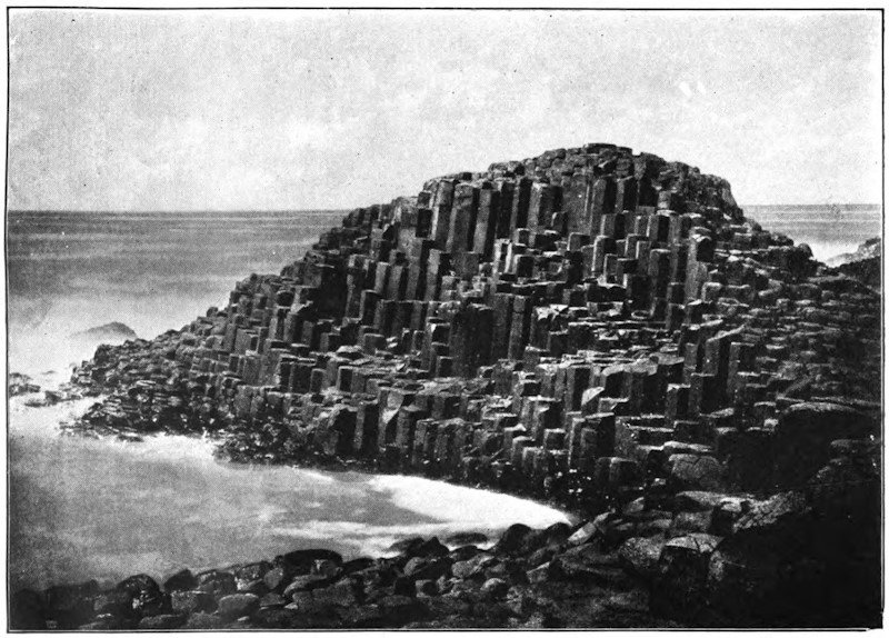
The Giant’s Causeway, Antrim, Ireland
Nearly all countries of the world possess some of these curious springs, which cover with a calcareous crust any object placed in their waters. Among these incrusting springs, those of Saint Allyre, near Clermont, Rivoli, and San Filippo, not far from Rome, have justly become celebrated. These latter have, in a space of twenty years, filled up a pond with a bed of travertin 30 feet thick, and, in the neighborhood, entire strata of this same rock may be seen having a depth of more than 328 feet. The springs of Hammam-Mes-Khoutine, in the province of Constantine, are also very remarkable on account of the considerable amount of their deposits. This water, which rises at a temperature of 203° (Fahr.), and from which a high column of steam always rises, is frequently compelled to change its point of issue on account of the dense beds of travertin which are gradually deposited upon the soil. Most of these deposits are of a dazzling white hue, striped here and there with bright colors, and are developed in mammillated strata; other concretions, accumulating gradually round an orifice, have taken the form of cones, and are like small craters near a volcano, some of them rising to a height of as much as 33 feet; lastly, there are masses of travertin which stretch out in a kind of wall below the flow which deposits them. One of these walls, which is interrupted at intervals by heaps of earth upon which large trees grow, is not less than 4,921 feet long, 66 feet high, and, on an average, from 33 to 49 feet wide.
The thermal waters of Algeria are, however, surpassed in grandeur and beauty by the springs of the ancient Ionian city of Hierapolis (holy city), which at the present time flow in the solitary plateau called Panbouk-Kelessi (Castle of Cotton), on account of the cotton-like aspect of the white masses of travertin of which it is composed. On reaching this spot from Smyrna, something like an immense cataract may be seen in the distance, 328 feet high and 2½ miles wide; this is formed by the walls which the water has gradually constructed, column after column, and layer after layer, by flowing over the edges of the plateau and gushing out on the slopes. Here and there, real cascades glitter in the sun, and their sparkling surfaces light up the dead whiteness of the crystal walls. As a spectator ascends the declivities, the masses deposited and carved out by the water appear in all their strange beauty; one might fancy that they were colonnades, groups of figures, and rude bas-reliefs which the chisel had not yet perfectly set free from their rough coverings of stone. And all these calcareous deposits which have been fashioned by the cascades during a succession of ages open a multitude of cup-like hollows with fluted edges fringed with stalactites; these graceful reservoirs—some of which are shaded with yellow or veined with red, brown, and violet, like jasper or agate—are filled with pure water. Higher still follow two steps of the plateau on which stood the ancient thermal edifice and the Necropolis of Hierapolis. There whitish masses cover the ancient tombstones and fill up the conduits. The ground is crossed in various directions by the former beds of rivulets, which have gradually stopped up their own courses by depositing concretions upon them. Above one of the widest of these dried-up channels, the magnificent span of a natural bridge displays its graceful form, like an arch of alabaster, streaming with innumerable stalactites. At what date did this majestic structure take its rise, and how many years and centuries did the process of its formation last? No one knows. According to Strabo, the channels of the baths of Hierapolis were soon filled up by solid masses, and if Vitruvius can be believed, when the proprietors of the environs wished to inclose their domain, they caused a current of water to run along the boundary-line, and in the space of a year the walls had risen.
Silica, which is still more important than chalk in the formation of terrestrial rocks, is also sometimes deposited on the edge of springs, but in very small quantities.
The various dislocations of the terrestrial strata, the cooling of the waters, and, perhaps, in many instances, the obstruction of channels by deposits of ore, explain why, in the present period, so small a number of thermal springs issue from metalliferous beds. Nevertheless, many localities might be mentioned where these phenomena take place at the present time. A spring at Badenweiler, in the Black Forest, issues forth at a few yards from a vein of sulphuret of lead. In the granitic plateau of central France other springs are likewise found to be associated with this metal. Various thermal waters in the Black Forest, like those of Carlsbad and Marienbad, are in close connection with veins of iron and manganese. Oligiste iron is found in the fissures of the springs of Plombières and Chaude-Fontaine. In Tuscany sulphureous fumaroles proceed from the veins of antimony. In France and Algeria the waters of Sylvanès and Hammam R’ira issue forth from beds of copper. Lastly, near Freyberg, a voluminous thermal spring has been discovered in a vein of silver.
Among the mineral substances which some springs bring to the surface of the soil, the most important, in an economical point of view, is common salt. This substance, being one of those which dissolve most readily in water, all the liquid veins which pass over saline beds become saturated with salt; therefore springs of this kind, which flow in great abundance, give rise to salt-works of more or less importance. The masses of common salt which make their way every year from the interior of the earth may be estimated at thousands of tons. The springs of Halle, which rise on the northern slope of the Alps of Salzburg (Salt Town), and are managed with the greatest care, annually produce 15,000 tons of this mineral. The salt springs of Halle, in Prussia, which have been worked from time immemorial by a company, furnish 10,000 tons of salt every year. Other parts of Germany also yield for consumption thousands of tons of white salt, which is produced by the evaporation of saline springs. The mass of salt furnished by the single artesian well of Neusalzwerk, near Minden, in Prussia, represents every year a cube measuring 78 feet on each side.
Though not so rich as Germany in saline springs thus turned to account, most of the civilized countries of the world possess salt-works which are also very important. France enjoys the springs of Dieuze, Salins, and Salies; Switzerland, those of Bex; Italy has the springs in the environs of Modena, and many others besides. In England, near Chester, there are some mines of rock-salt in which numerous liquid veins issue forth which are impregnated with salt. Lastly, the United States have the celebrated springs of Syracuse.
Not far from the “spot where Troy once stood” is the valley of Touzla-sou, which owes its name (Salt Water) to its numerous salt springs. The mountains which rise around its circumference are variously shaded with blue, red, and yellow, and the rocks are incessantly decomposing under the action of the liquid salt which oozes out from and trickles down their sides. The plain itself is covered with a variegated crust, while jets of boiling water, saturated with salt, burst forth in every direction. Here and there pools are found, the moisture of which, by evaporating in the sun, leaves upon the soil beds of salt as white as snow. Near the mouth of the valley springs become more and more numerous. Lastly, in the place where the cliffs approach near together, so as to form a defile, a magnificent spout of water jets out from one side of the rock. This jet is not less than a foot in diameter at the orifice, and falls again after having described a parabola of more than a yard and a half. Other springs shoot out on both sides, the constant temperature of which is more than 212° (Fahr.); these, together with the principal jet, form a rivulet of boiling and steaming water.
Springs of salt water are used for the treatment of diseases as well as for the extraction of salt. They constitute one of the most important groups of medicinal waters, according to the various substances which they contain in solution. The other springs made use of, on account of their healing virtues, have been classed under ferruginous, sulphureous, and acidulous springs. These waters also contain, in different proportions, a variable quantity of gases and salts which they have dissolved in their passage over subterranean beds of every kind.
Mineral springs are most numerous and abundant in mountain valleys, and there, consequently, the great thermal institutions are established. In Europe the chain of the Pyrenees is probably the richest in mineral, sulphureous, saline, ferruginous, and acidulous springs. According to Francis, the engineer, in 1860 more than 550 mineral springs, 187 of which are used, flowed upon the French slopes of the Pyrenees. These waters supplied 83 hot baths in 53 localities, the principal of which are Bagnères de Bigorre, Luchon, Eaux-Bonnes, and Cauterets. The most abundant springs, those of Graus d’Olette, form a sort of mineral stream, yielding more than four gallons a second, or 2,322 cubic yards a day. In Algeria the spring of Hammam-Mes Khoutine yields 6 gallons a second.
There are regions, some volcanic and some not, in which nearly all the springs are thermal and mineral; springs of pure and fresh water being so rare, they are there considered to be most precious treasures. One of these regions comprehends a large part of the plateau of Utah. In this place numerous thermal springs issue forth, to which have been given the vulgar names of the Beer, Steamboat, Whistle Springs, etc., and into one of which the Mormons plunge their neophytes. The springs which are not thermal are loaded with saline and calcareous matter. It is only in spring, at the time when the snow melts, that the springs, which then become very abundant, yield comparatively pure water. During the dry season, salt and carbonate of lime become concentrated in the nearly exhausted springs, and give to the liquid flow an unpalatable taste. Palgrave, the traveler, informs us that all the springs of the country of Hasa, in Arabia, are also thermal.
It can readily be understood that when all these substances escape from the interior of the rocks, together with the water which holds them in solution, they must leave empty spaces in the earth. During the course of long centuries whole strata are dissolved, and, under a form more or less chemically modified, are brought up from the depths and distributed on the surface of the soil. The thermal waters of Bath, which are far from being remarkable for the proportion of mineral substances they contain, bring to the surface of the earth an annual amount of sulphates of lime and soda, and chlorides of sodium and magnesium, the cubic mass of which is not less than 554 cubic yards. It has also been calculated that one of the springs of Louèche, that of Saint Laurent, brings every year to the surface 8,822,400 pounds of gypsum, or about 2,122 cubic yards; this quantity is enough to lower a bed of gypsum a square mile in extent, more than five feet in one century. But this is only one spring, and we have reckoned one century only; if we think of the thousands of mineral springs which gush from the soil, and of the immensity of time during which their waters have flowed, some idea may be formed of the importance of the alterations caused by springs. In time they lower the whole mass of mountains, and, no doubt, after these sinkings, violent oscillations of the earth may often have taken place.
In regions where the strata are pierced with wide and deep caverns, and especially in calcareous countries, the waters sometimes accumulate in sufficient quantities to form perfect streams with long subterranean courses. At their issue from the caverns, these waters form a contrast with the rocks and hills around, all the more striking because the latter are completely devoid of moisture, and fearfully sterile, while on the brink of the limpid stream the fresh verdure of plants and trees is at once developed. Like a captive, joyous at seeing the light once more, the water which shoots forth from the sombre grotto of rocks sparkles in the sun, and careers along with a light murmur between its flowery banks.
Among these subterranean streams, the most celebrated, and doubtless one of the most beautiful, is the Sorgues of Vaucluse. The vaulted grotto from which the mighty mass of water escapes opens at the mouth of an amphitheatre of calcareous rocks with perpendicular sides. Above the spring rises a high white cliff, bearing on its summit a ruined tower of the Middle Ages; the rock is everywhere sterile and bare; there is nothing but a miserable fig-tree, clinging to the stone like a parasitical plant to the bark of a tree, which has plunged its roots into the fissure of the cave, and greedily absorbs with its leaves the moisture which floats like a mist above the cascades of the spring. After heavy rains, the liquid mass, which is then estimated at 26 or even 32 cubic yards a second, flows in a wide sheet high above the entrance to the cavern, which is then altogether inaccessible. When the waters are low, they flow bubbling across the barrier of rocky débris which obstructs the entrance; at that time it is quite possible to penetrate under the arch, and to contemplate the vast basin in which the blue waters of the subterranean stream spread out before they leap into the open air. Soon after its issue from the cave and amphitheatre of Vaucluse, the Sorgues is divided into numerous irrigation channels, which spread fertility in the country over an area of more than 77 square miles. The subterranean course of the affluents which form the stream is not ascertained; but it is known that most of them commence 12 or 15 miles to the east, in the plateaus of Saint Christol and Lagarde, which are pierced all over with avens or chasms, into which the rain-water sinks and disappears.
In another part of France there is a second important subterranean stream, which is much less known but no less remarkable than that of Vaucluse; this is the Touvre of Angoulême, continuing the course of the Bandiat, the waters of which, like those of the Tardoire, are swallowed up in several abysses at distances varying from 3 to 7 miles to the east and northeast. The three principal springs of the Touvre flow slowly out of a deep cave, hollowed out at the base of an escarped cliff; another spring bubbles up in a basin of rock; the third emerges from a sort of boggy meadow intersected by drains. At the outlet of their subterranean courses these three enormous springs immediately form three streams, which reunite, leaving between them two long peninsulas of reeds and other aquatic plants. Below the junction, the Touvre, which is here more than 100 yards wide, passes round a rugged hill, and, dividing into several branches, turns the numerous mill-wheels of the important gun-foundry of Ruelle; then, after a course of five miles, it flows into the Charente at a small distance above Angoulême. Among the hundreds and thousands of travelers whom steam annually conveys over the bridge of the Touvre, there are few who are aware of the curious nature of the source of the river of limpid water over which the train passes in its noisy career.
Omitting to mention the streams which accidentally pass under the strata of rocks during a small part of their course, or of the subterranean outlets of certain lakes, a multitude of other instances might be brought forward of masses of water, more or less abundant, which appear above ground after having traversed a considerable distance under the earth. Of this kind is the graceful spring of Nîmes, the blue transparent water of which, reflecting the foliage of pines and chestnut trees, glides in its gentle ripples over the semicircular steps of an old Roman staircase. Of this kind, too, is the spring of Vénéran, near Saintes: this spring, which was formerly sacred to the Goddess of Love, gushes from the ground in a gorge of rocks, and, passing through a mill, the wheel of which it turns, it suddenly disappears, being swallowed up in an abyss; thus it appears on the earth to work but for an instant.
Numbers of water-courses do not reappear on the surface of the soil after being swallowed up in the earth, but flow straight to the sea by means of subterranean channels. On nearly the whole extent of the continental shores, and principally in localities where the coasts are of a calcareous nature, the outlets of submarine tributaries may be noticed, some of which are perfect rivers. Most of the springs of the department of Bouches du Rhone jet up from the bottom of the sea, but at various distances from the shore. One of them, that of Porte Miou, near Cassis, forms on the surface of the sea a considerable current, which drifts any floating bodies to a great distance. At Saint Nazaire, Ciotat, Cannes, San Remo, and Spezzia, other streams also issue from the midst of the salt waves, and attempts have even been made to measure approximately their discharge. M. Villeneuve-Flayosc estimates at 24 cubic yards a second the quantity of water discharged into the sea by all the hidden affluents of the Mediterranean between Nice and Genoa. Some of the submarine springs of Provence and Liguria proceed from enormous depths. The orifice of the spring of Cannes is 531 feet below the level of the sea; that of San Remo rises from a depth of 954 feet; lastly, at four miles to the south of Cape Saint Martin, between Monaco and Mentone, another stream of fresh water empties itself under a bed of salt water, near 2,296 feet deep.
The coasts of Algeria, Istria, Dalmatia, and the Herzegovina also present numerous instances of submarine streams; on the eastern shores of the Adriatic the traveler may even have the pleasure of contemplating the delta of a considerable river, the Trebintchitza, visible through the sea-water at the depth of a yard. The abundant springs of fresh water which pour out into the open sea to the southwest of the Cuban port of Batabano are well known, since Humboldt described them, and it is observed that the lamantins, or sea-cows, which dread salt water, delight in frequenting these parts. Lastly, the Red Sea, which does not throughout its immense circumference receive a single permanent stream flowing on the surface of the ground, nevertheless receives some which spring from the bottom of its bed. The shores of the United States, the calcareous soil of which is probably pierced with caverns from the very centre of the continent, perhaps are the coasts which pour into the sea the most abundant subterranean rivers. Near the mouth of the stream of St. John, a submarine stream of perfectly pure water spouts in bubbles as far as one to two yards above the level of the sea. Off the Carolinas, and Florida, salt water has been known to change into brackish water under the influence of the sudden increase of its subterranean affluents. In the month of January, 1857, all that part of the sea which is adjacent to the southern point of Florida was the scene of an immense eruption of fresh water. Muddy and yellowish water furrowed the straits, and myriads of dead fish floated on the surface and accumulated on the shores. Even in the open sea the saltness diminished by one-half, and in some places the fishermen drew their drinking-water from the surface of the sea as if from a well. It is affirmed by all those who witnessed this remarkable inundation of the subterranean river that, during more than a month, it discharged at least as much water as the Mississippi itself, and spread over all the strait, 31 miles wide, which separates Key West from Florida.
On the coasts of Yucatan, the fresh waters which take a subterranean course down to the sea do not appear to flow like rivers which have a narrow bed and attain considerable speed, but more in the form of a wide sheet of liquid with a nearly imperceptible current. Cenotes open here and there over the surface of the country; they are a kind of natural draining-well or hole, not very deep, into which the inhabitants descend to draw spring water. At Merida and in the environs the subterranean water is found at a depth of 26 to 30 feet; but the nearer we approach to the sea the thinner the layer of rock becomes which covers the liquid veins; on the seashore fresh water is found nearly on a level with the soil. The height of the veins varies several inches, according to the quantity of rain; but in every season the mass of water descending from the plateau of Yucatan is poured into the sea through innumerable outlets. Over a great extent of the shore of the peninsula, these hidden springs furnish collectively a mass sufficiently large to counterpoise the waters of the sea. Under the pressure of the marine current which runs along the coast, there is formed, between the open sea and the liquid mass which has made its way from the land, a littoral bank like those barriers which the waves construct before the mouths of rivers. This embankment, which protects the coasts of Yucatan like a breakwater, is not less than 171 miles long, and is cut through by the sea at two or three points. The channel, which stretches like a wide river between the bank of alluvium and the Yucatan coast, is, not without reason, designated by the inhabitants by the name of stream or rio.
Among the remarkable phenomena which perhaps owe their existence to subterranean water-courses, we must mention the sudden or gradual appearance of those hillocks of clay (“mud-lumps”) which rise, to the great danger of navigators, either in the middle of the bar of the Mississippi, or in the immediate vicinity. Like small volcanoes of mud, the “mud-lumps” generally appear under the form of isolated cones, allowing a rill of dirty water to escape from their summits. Some of them are irregular on their surface, on which lateral orifices here and there show themselves, some in full activity, others abandoned by the springs which formerly gushed from them. The water of some “mud-lumps” is loaded with oxide of iron or carbonate of lime, which, with the agglutinated sands, form hard masses, having the consistence of perfect rocks. These hillocks vary both in their height and shape. The greater part remain hidden at the bottom of the water, and even their summits do not reach the level of the river or sea; others hardly raise their heads above the waves; the most considerable, however, rise to a height of 6, 9, or even 19 feet, and their base covers an area of several acres. The sudden way in which most of these water-volcanoes make their appearance, the anchors of vessels, and the remains of cargoes which have been found on their surface, their conical form, their terminal craters, and all the springs, “which seem to spout out as if from a subterranean sieve,” indicate the existence of a subterranean force always at work to upheave this band of hillocks.
M. Thomassy is of opinion that the hillocks of these bars are the orifices of regular artesian wells naturally formed by a sheet of subterranean water descending from the plateaus of the interior and flowing below the Mississippi and the clayey levels of Louisiana. However this may be, the mode in which these mud hillocks are formed is well enough known to render it easy to clear them away from the mouths of the Mississippi and to protect the interests of navigation. When a cone of clay makes its appearance on the bar, a charge of powder is introduced into it and explodes it. Thus, in the year 1858, the southwest passage was cleared of a “mud-lump” which formed a considerable island; a single charge was sufficient to annihilate the whole. The island suddenly sunk; in its place a wide depression was formed, the circumference of which resembled that of a volcanic crater; at the same time an enormous quantity of hydrogen gas was discharged into the atmosphere.
Above the springs the course of subterranean rivulets is generally indicated by a series of chasms or natural wells, which disclose the stream beneath. The arches of caves not being always strong enough to support the weight of the superincumbent masses, they necessarily fall in some places, leaving above them other spaces into which the upper beds successively sink. The débris of the ruin is afterward cleared away by the water, or dissolved, atom by atom, by the carbonic acid contained in the stream, and gradually all the loose rubbish is carried away. In this manner, above the subterranean rivulets, a kind of well is formed, which is designated in various countries by very different names.
By means of these natural gulfs it is possible to reach the subterranean streams, and to give some account of their system, which is exactly like that of rivulets and rivers flowing in the open air. These streams also have their cascades, their windings, and their islands; they also erode or cover with alluvium the rocks which compose their bed, and they are subject to all the fluctuations of high and low water. The only important difference which superficial waters and subterranean currents present in their phenomena is that these streams in some places fill the whole section of the cave, and are thus kept back by the upper sides, which compress the liquid mass. In fact, the spaces hollowed out by the waters in the interior of the earth are only in a few places formed into regular avenues, which might be compared to our railway tunnels. Where beds of hard stone oppose the flow of the rivulet, all it has done during the course of centuries has been to hew out one narrow aperture. This succession of widenings and contractions, similar to those of the valleys on the surface, forms a series of chambers, separated one from the other by partitions of rock. The water spreads widely in large cavities, then, contracting its stream, rushes through each defile as if through a sluice.
On account of these partitions, it is very difficult, or even impossible, to navigate the course of subterranean rivers to any considerable distance, even at the time the water is low. When it is high, the liquid mass, detained by the partitions, rises to a very high level in the large interior cavities, and often reaches the roof above. Sometimes when, through the clefts of the rocks, a communication exists between the cave and some hollow above, the surplus water from the subterranean streams makes its appearance there. Thus the Recca, which flows beneath the adjacent plateau of Trieste, does not always find space enough to flow freely in its lower channels, and Schmidt has seen it ascend in the chasms of Trebich to a height of 341 feet. It may be understood that the pressure of such a column of water often shatters enormous pieces of rock, and thus modifies the course of underground streams.
When the water, impelled by force of gravitation, seeks a new bed in the cavernous depths of the earth, and disappears from its former channels, these are at first much easier of access than they formerly were; but ere long, in most caves, a new agent intervenes, which seeks to contract or even completely obstruct them. This agent is the snow-water, or rain, which percolates, drop by drop, through the enormous filter of the upper strata. In passing through the calcareous mass, each one of these drops dissolves a certain quantity of carbonate of lime, which is afterward set free on the arch or the sides of the cave. When the drop of water falls, it leaves attached to the stone a small ring of a whitish substance; this is the commencement of a stalactite. Another drop trickles down, and, trembling on this ring, lengthens it slightly by adding to its edges a thin circular deposit of lime, and then falls. Thus drop succeeds drop in an infinite series, each depositing the particles of lime which it contains, and forming ultimately a number of frail tubes, round which the calcareous deposit slowly accumulates. But the water which drops from the stalactites has not yet lost all the lime which it held in solution; it still retains sufficient to enable it to elevate the stalagmites and all the mammillated concretions which roughen or cover the floor of the grotto. It is well known what fairy-like decorations some caverns owe to this continuous oozing through the vaults of their roofs. There are few sights in the world more astonishing than that of these subterranean galleries, with their dead-white columns, their innumerable pendants and multiform groups, like veiled statues, all yet unstained by the smoke of the visitor’s torch.